Settlements around Indus Threatened With rise in temperatures, glaciers receding, increase in rainfall and tributaries changing course settlements
|
|
|
- Clifton Montgomery
- 5 years ago
- Views:
Transcription


1 INTRODUCTION Over the centuries the Indus has been the life line for several civilizations. In Ladakh most of the villages have come up on the north bank along the tributaries that are fed by the glacial melt into the Indus. It is now these very villages along the north bank of the Indus belt in Ladakh that have been affected.


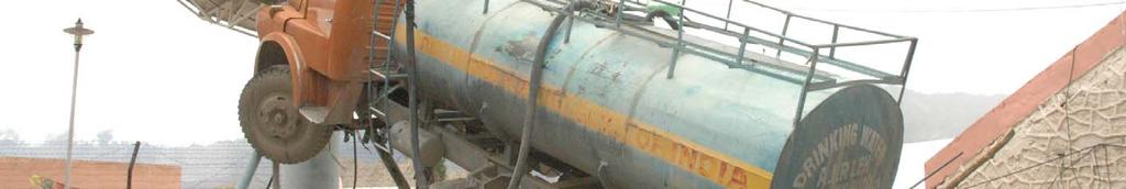
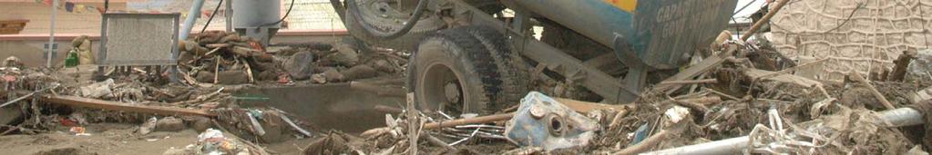
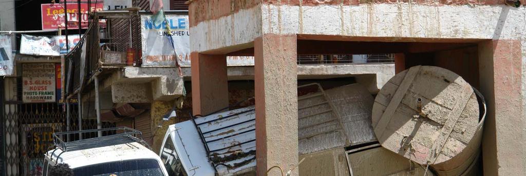
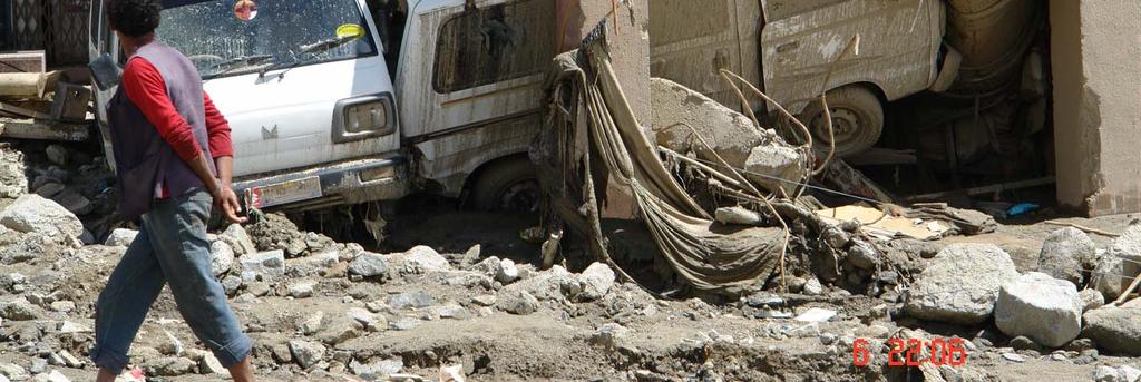
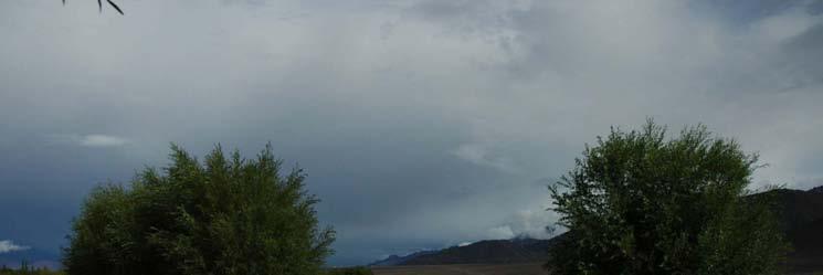
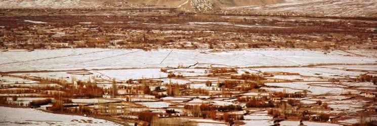
2 Settlements around Indus Threatened With rise in temperatures, glaciers receding, increase in rainfall and tributaries changing course settlements are now being threatened. In the past, changing course of the Indus has destroyed civilizations flattening of Tashi Ghatsal is perhaps reminiscent of destruction of Harappa and Mohenjodharo. The entire township lies buried under mud.
 in recent history.")

3 History of floods in Ladakh Ladakh witnessed many Glacial Lake Outbursts Floods (GlOFS) in recent history. Bursting of glacial lake formed by blocking of Shayok River by surging of Chong Kumdan glacier in 1930s was best documented GLOFS in Ladakh.

4 History of Flood in Ladakh Around 1907 it is believed that present Leh bazaar was filled with mud that rose to its current level witnessed massive destruction due to flood in Nyemo village, following which Save the Children UK was first set up in Leh. After nearly 30 years in 1999 Leh valley caught unaware of a flood that destroyed fields and houses and killed many animals.


5 2006 floods in Phyang and Leh valleys It was clearly observed that floods in Leh and Phayang Tokpo were due to the bursting of recessional glacial lakes of Phuche glacier in Leh valley. In the catchment of Phiyang Tokpo, the terminal moraines of Phyang glacier has breached resulting in GLOF. On preliminary investigations, it is suggested that the melting of ice cored moraine resulted into the lake burst. Increase in the summer precipitation has also contributed to increase in the water level of the lakes due the increased melting of glaciers over height of 5,500m. An important factor that has not been given its due importance is the melting of the mountain permafrost with the increase in global temperature. This is not only destabilizing the mountain slopes but also contributing to increase of melt water flow into glacial lakes: Dr. Joseph Gergan Geologist

 in Ladakh.")


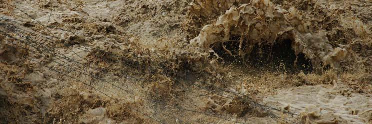
6 Flash floods and cloudburst in 2010 Increased temperature and hot summers in the plains lead to increased evaporation and subsequent cloud formation in the hills. This lead to increased duration of snowfall (May) in Ladakh. Winter prolonged. Bright sunshine in June and July lead to melting of snow and high relative humidity (72%) against 50% of previous years. Since snow absorbed latent heat also, monthly max and min temp remained low leading to dense low clouds in the valley. Clouds further condensed trying to cross the glaciers and could not retain the water droplets and burst. DIHAR
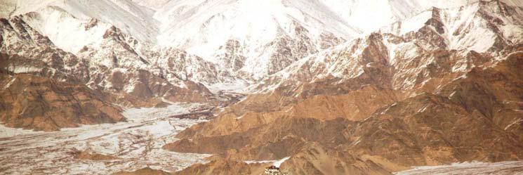
7 More Frequent and Vulnerable areas developed leading to greater damage Ladakh has witnessed floods in the past, what has changed is the frequency and significantly vulnerable areas are now developed and populated leading to greater damage A remnant of an old stream bed lie on the mountain ridge above Shagsha liung, clearly seen on google map, going west towards Leh and east towards Sabu and Choglamsar provides evidence of water flow in the past.


8
9
10
11
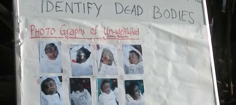
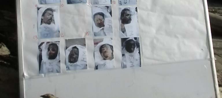
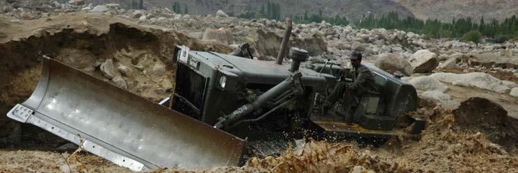
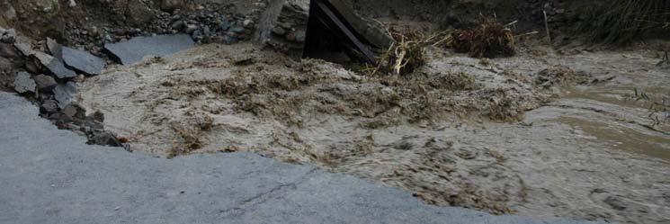
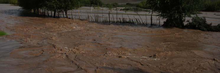
12 Destruction 223 declared dead and still many missing About 1000 houses destroyed/washed away acres of land both cultivable and non cultivable land (plantations) covered under debris/washed away. 15 crore loss to hospital including CT Scan Water lifting pump for the town washed away govt. offices, schools, electricity, BSNL
13 Nidder Flood also GLOF Nidder flood on October 8, 2010 was again a GLOF Last time it was around 60 years back Nidder witnessed flood because of lake burst. There are two lakes by names Longdol and Chorog in different sub valleys. Chorog is the name for three lakes, formed one after another at different levels. Longdol is in Longma valley (caragana valley), which is one big glacial lake that got breached by breaking of ice block. Jigmet Stobdan 26, village representative, said, it was unusually hot that day when flood hit. Stobdan had heard from his elders that their ancestors often used to manually breach the glacial lake to release the water rising in the lake in controlled manner, which is no more practiced.
14 Possible measures Short term There is an urgent need for the preparation of inventory of the glacial lakes of Ladakh and identify them according to their vulnerability to failure. Monitoring of glacier lakes and development of an early warning system to fore warn the occurrence of GLOF in advance to public living down stream needed immediate attention.
15 Long term Numerous moraines created by centuries of glacial melt could work as small, manageable check dams to preserve the water and also to rejuvenate the springs. Even the remaining glacier could be provided by artificial cover from sun as they do in Switzerland or other countries facing glacier recession. In addition, artificial glaciers along side hills could also be effective as one of the measures not only to preserve glaciers and entailing vast stretch of permafrost, which act as natural water reserves that form the lifeline of a civilization.
16

17

18 Khardong la glacier
19

20
21
22


23 Pangong Lake s road submerged


24 Drang drung glacier in Zanskar
Adaptation in the Everest Region
 Adaptation in the Everest Region Bhawani S. Dongol Program Officer-Freshwater Program WWF- The Global Conservation Organization bhawani.dongol@wwfnepal.org 26 March 2010 Himalayan water towers The Himalayan
Regional impacts and vulnerability mountain areas
 Regional impacts and vulnerability mountain areas 1 st EIONET workshop on climate change vulnerability, impacts and adaptation EEA, Copenhagen, 27-28 Nov 2007 Klaus Radunsky 28 Nov 2007 slide 1 Overview
How Glaciers Change the World By ReadWorks
 How Glaciers Change the World How Glaciers Change the World By ReadWorks Glaciers are large masses of ice that can be found in either the oceans or on land. These large bodies of frozen water have big
Climate Change Impacts on Glacial Lakes and Glacierized Basins in Nepal and Implications for Water Resources
 Climate Change Impacts on Glacial Lakes and Glacierized Basins in Nepal and Implications for Water Resources Suresh R. Chalise 1, Madan Lall Shrestha 2, Om Ratna Bajracharya 2 & Arun Bhakta Shrestha 2
GEOSPATIAL ANALYSIS OF GLACIAL HAZARDS PRONE AREAS OF SHIGAR AND SHAYOK BASINS OF PAKISTAN. By Syed Naseem Abbas Gilany
 GEOSPATIAL ANALYSIS OF GLACIAL HAZARDS PRONE AREAS OF SHIGAR AND SHAYOK BASINS OF PAKISTAN By Syed Naseem Abbas Gilany PRESENTATION OUTLINE Introduction Problem Statement / Rationale Objectives Material
GLOFs from moraine-dammed lakes: their causes and mechanisms V. Vilímek, A. Emmer
 GLOFs from moraine-dammed lakes: their causes and mechanisms V. Vilímek, A. Emmer Department of Physical Geography and Geoecology, Faculty of Science, Charles University, Prague, Czech Republic vilimek@natur.cuni.cz
Climate Change Impact on Water Resources of Pakistan
 Pakistan Water and Power Development Authority (WAPDA) Climate Change Impact on Water Resources of Pakistan Glacier Monitoring & Research Centre Muhammad Arshad Pervez Project Director (GMRC) Outline of
Managing Disasters, Sustaining Development in the Hindu Kush Himalayas
 Managing Disasters, Sustaining Development in the Hindu Kush Himalayas Aditi Mukherji Theme Leader, Water and Air ICIMOD amukherji@icimod.org International Centre for Integrated Mountain Development Kathmandu,
Impacts of climate change and water induced disasters in high altitude on hydropower development in Nepal. Rijan Bhakta Kayastha, D. Sc.
 Impacts of climate change and water induced disasters in high altitude on hydropower development in Nepal Rijan Bhakta Kayastha, D. Sc. Associate Professor and Coordinator Himalayan Cryosphere, Climate
Snow, Glacier and GLOF
 Snow, Glacier and GLOF & Report on Demonstration River Basin Activities Upper Indus Basin The 5th International Coordination Group (ICG) Meeting GEOSS Asian Water Cycle Initiative (AWCI) Tokyo, Japan,
Glacier Risks. Possibilities and Limits of Prevention and Mitigation. Jörg Hanisch Hannover, Germany John M. Reynolds Mold, UK
 Glacier Risks Possibilities and Limits of Prevention and Mitigation Jörg Hanisch Hannover, Germany John M. Reynolds Mold, UK Glacier Hazards Ice Falls, Surges, and Avalanches Glacier Hazards Glacier Hazards
GLACIATION. The Last Ice Age (see Chapter 12) and. Pleistocene Ice Cap. Glacial Dynamics 10/2/2012. Laurentide Ice Sheet over NYS
 and. Pleistocene Ice Cap. Glacial Dynamics 10/2/2012. Laurentide Ice Sheet over NYS") GLACIATION and New York State Prof. Anthony Grande The Last Ice Age (see Chapter 1) The Pleistocene Epoch began 1.6 mya. During this time, climates grew colder. There were numerous ice ages starting 100,000000
GLACIATION and New York State Prof. Anthony Grande The Last Ice Age (see Chapter 1) The Pleistocene Epoch began 1.6 mya. During this time, climates grew colder. There were numerous ice ages starting 100,000000
The Potentially Dangerous Glacial Lakes
 Chapter 11 The Potentially Dangerous Glacial Lakes On the basis of actively retreating glaciers and other criteria, the potentially dangerous glacial lakes were identified using the spatial and attribute
Glaciers, Glacial Lakes and GLOF
 Glaciers, Glacial Lakes and GLOF N Samjwal Ratna Bajracharya International Centre for Integrated Mountain Development Kathmandu, Nepal Inventory of Glaciers, Glacial Lakes and GLOF in the Himalaya Afghanistan
Impact of Climate Change in the Hindu Kush-Himalayan Region
 Impact of Climate Change in the Hindu Kush-Himalayan Region Basanta Shrestha (bshrestha@icimod.org), Division Head MENRIS, ICIMOD Focus on Glacial Lake Outburst Floods (GLOFs) Sentinel Asia JPTM Step 2
Glaciology. Water. Glacier. Moraine. Types of glacier-dammed lakes. Mechanics of jökulhlaup
 A Jökulhlaup Jökulhlaup. Catastrophic events where large amounts of water are suddenly discharged. Jökulhlaup s are a sudden and rapid draining of a glacier dammed lake or of water impounded within a glacier.
New measurements techniques
 2 nd Asia CryoNetWorkshop New measurements techniques Xiao Cunde (SKLCS/CAS and CAMS/CMA) Feb.5, 2016, Salekhard, Russia Outline Definition of New Some relative newly-used techniques in China -- Eddy covariance
Glaciers and Glacial Lakes under Changing Climate in Pakistan
 Pakistan Journal of Meteorology Vol. 8, Issue 15 Glaciers and Glacial Lakes under Changing Climate in Pakistan Rasul, G. 1, Q. Z. Chaudhry 2, A. Mahmood 2, K. W. Hyder 2,3, Qin Dahe 3 Abstract The Himalayas,
Observation of cryosphere
 Observation of cryosphere By Sagar Ratna Bajracharya (email: sagar.bajracharya@icimod.org) Samjwal Ratna Bajracharya Arun Bhakta Shrestha International Centre for Integrated Mountain Development Kathmandu,
Snow/Ice melt and Glacial Lake Outburst Flood in Himalayan region
 Snow/Ice melt and Glacial Lake Outburst Flood in Himalayan region Dr. SANJAY K JAIN NATIONAL INSTITUTE OF HYDROLOGY ROORKEE Modelling and management flood risk in mountain areas 17-19 Feb., 2015 at Sacramento,
1.4 Understand how moving ice acts as an agent of erosion and deposition. (Chap. 2)
") 1.4 Understand how moving ice acts as an agent of erosion and deposition. (Chap. 2) There are two types of glaciation. Alpine Glaciation Continental Glaciation Distinguish between the terms alpine glaciation
1.4 Understand how moving ice acts as an agent of erosion and deposition. (Chap. 2) There are two types of glaciation. Alpine Glaciation Continental Glaciation Distinguish between the terms alpine glaciation
The Physical Geography of Long Island
 The Physical Geography of Long Island A Bit About Long Island Length 118 miles Brooklyn to Montauk Geo202 Spring 2012 Width 23 miles at it s widest Area 1,400 square miles Formation of Long Island River
Himalayan Glaciers Climate Change, Water Resources, and Water Security. Henry Vaux, Committee Chair December 10, 2012
 Himalayan Glaciers Climate Change, Water Resources, and Water Security Henry Vaux, Committee Chair December 10, 2012 Study Context Glacial meltwater is commonly thought h to significantly ifi contribute
The Inventory of Glacial Lakes
 Chapter 8 The Inventory of Glacial Lakes 8.1 BRIEF DESCRIPTION OF GLACIAL LAKE INVENTORY The inventory of glacial lakes has been systematically carried out using topographic maps. As not all the topographic
Annual Weather Book RECORDED BY NW RESEARCH & OUTREACH CTR. By: Michael Leiseth
 Annual Weather Book RECORDED BY NW RESEARCH & OUTREACH CTR. By: Michael Leiseth Table I II 1 2 3 4 5 6 7 8 9, 10 11, 12 13, 14 15, 16 17 18 An average year in Crookston, MN. Seasonal extremes in Crookston,
Glaciers. Reading Practice
 Reading Practice A Glaciers Besides the earth s oceans, glacier ice is the largest source of water on earth. A glacier is a massive stream or sheet of ice that moves underneath itself under the influence
Did It. naturalists. Young. Moving and melting ice shaped many of Minnesota s land features. 30 Minnesota Conservation Volunteer
 Young naturalists by Mary Hoff Photography by Gary Alan Nelson T he Glacier Did It Moving and melting ice shaped many of Minnesota s land features. Shut your eyes. Imagine that it s a sunny summer day
Geography 120, Instructor: Chaddock In Class 13: Glaciers and Icecaps Name: Fill in the correct terms for these descriptions: Ablation zone: n zne:
 Geography 120, Instructor: Chaddock In Class 13: Glaciers and Icecaps Name: Fill in the correct terms for these descriptions: Ablation zone: The area of a glacier where mass is lost through melting or
Implications of the Ice Melt: A Global Overview
 Implications of the Ice Melt: A Global Overview Hindu Kush Himalayas International Centre for Integrated Mountain Development Kathmandu, Nepal Our Ice Dependent World The 6th Open Assembly of the Northern
Q: What is a period of time whereby the average global temperature has decreased? Q: What is a glacier?
 Q: What is a glacier? A: A large sheet of ice which lasts all year round. Q: What is a period of time whereby the average global temperature has decreased? A: A glacial. Q: What is an interglacial? Q:
KNOWLEDGE NOTE 1-3. Hydro-meteorological Disasters Associated with Tsunamis and Earthquakes. CLUSTER 1: Structural Measures
 Public Disclosure Authorized Public Disclosure Authorized Public Disclosure Authorized Public Disclosure Authorized KNOWLEDGE NOTE 1-3 CLUSTER 1: Structural Measures Hydro-meteorological Disasters Associated
Glacial Lake Outburst Flood Mitigation Measures, Monitoring and Early Warning Systems
 Chapter 12 Glacial Lake Outburst Flood Mitigation Measures, Monitoring and Early Warning Systems There are several possible methods for mitigating the impact of Glacial Lake Outburst Flood (GLOF) surges,
Dynamic Planet C Test
 Northern Regional: January 19 th, 2019 Dynamic Planet C Test Name(s): Team Name: School Name: Team Number: Rank: Score: Dynamic Planet B/C Glaciers (87 total points) Multiple choice/fill in the blank (23
Climate Change and State of Himalayan Glaciers: Issues, Challenges and Facts
 Climate Change and State of Himalayan Glaciers: Issues, Challenges and Facts D.P. Dobhal dpdobhal@wihg.res.in Wadia Institute of Himalayan Geology Dehra Dun Major Issues Are the Himalayan glaciers receding
"ST. KLIMENT OHRIDSKI FACULTY OF GEOLOGY AND GEOGRAPHY
 SOFIA UNIVERSITY "ST. KLIMENT OHRIDSKI FACULTY OF GEOLOGY AND GEOGRAPHY APPLICATION OF THE MODEL "DRIVING FORCES PRESSURE STATE - RESPONSE FOR ASSESSMENT OF FLOOD RISK RADOSTINA BORISOVA DOCHEVA Bachelor
Tuesday 19 May 2015 Afternoon
 Oxford Cambridge and RSA F Tuesday 19 May 2015 Afternoon GCSE GEOGRAPHY A A731/01 Contemporary Themes in Geography (Foundation Tier) *2789690473* Candidates answer on the Question Paper. OCR supplied materials:
Mighty Glaciers. Mighty Glaciers. Visit for thousands of books and materials.
 Mighty Glaciers A Reading A Z Level M Leveled Reader Word Count: 684 LEVELED READER M Mighty Glaciers Written by Ned Jensen Visit www.readinga-z.com for thousands of books and materials. www.readinga-z.com
Glacial Lake Outburst Flood (GLOF) hazards in the Upper Indus basin
 hazards in the Upper Indus basin") Glacial Lake Outburst Flood (GLOF) hazards in the Upper Indus basin International Conference on Climate and environment change impacts on the Indus basin waters 16-19 February 2016 Samjwal Ratna Bajracharya,
Glacial Lake Outburst Flood (GLOF) hazards in the Upper Indus basin International Conference on Climate and environment change impacts on the Indus basin waters 16-19 February 2016 Samjwal Ratna Bajracharya,
Glacial Lake Outburst Floods and Damage in the Country
 9.1 INTRODUCTION Chapter 9 Glacial Lake Outburst Floods and Damage in the Country Periodic or occasional release of large amounts of stored water in a catastrophic outburst flood is widely referred to
Monitoring of Mountain Glacial Variations in Northern Pakistan, from 1992 to 2008 using Landsat and ALOS Data. R. Jilani, M.Haq, A.
 Monitoring of Mountain Glacial Variations in Northern Pakistan, from 1992 to 2008 using Landsat and ALOS Data R. Jilani, M.Haq, A. Naseer Pakistan Space & Upper Atmosphere Research Commission (SUPARCO)
Glaciers. Valley or Alpine glaciers. Ice sheets. Piedmont - foot of the mountain glaciers. Form in mountainous areas Move downslope in valleys
 Glaciers & Ice Ages Glaciers Valley or Alpine glaciers Form in mountainous areas Move downslope in valleys Ice sheets Move outward from center Continental glaciers - large scale, ice age type. Presently
A trip to Steindalen. - geology and landscape on the way to the glacier. Geoffrey D. Corner
 A TRIP TO STEINDALEN Excursion guide Please take this with you on your trip, but don t leave it behind as litter. A trip to Steindalen - geology and landscape on the way to the glacier A part of Geologiskolen,
Kirat Kamal Sampang Rai CLIMATE CHANGE AND ITS IMPACT ON INDIGENOUS PEOPLES IN NEPAL HIMALAYA. 60 Indigenous Affairs 1-2/08 4/07
 Kirat Kamal Sampang Rai CLIMATE CHANGE AND ITS IMPACT ON INDIGENOUS PEOPLES IN NEPAL HIMALAYA 60 Indigenous Affairs 1-2/08 4/07 Glacial lake on the brink of bursting - Photo: Kamal Rai Indigenous peoples
1 Glacial Erosion and
 www.ck12.org Chapter 1. Glacial Erosion and Deposition CHAPTER 1 Glacial Erosion and Deposition Lesson Objectives Discuss the different erosional features formed by alpine glaciers. Describe the processes
Climate Change Adaptation in
 Climate Change Adaptation in the Hindu Kush Himalaya Experience from the Great Himalaya Trail My Climate Initiative ----------------------- ----------------------- PARIBESH PRADHAN Overview The Great Himalaya
Recrystallization of snow to form LARGE. called FIRN: like packed snowballs. the weight of overlying firn and snow.
 Chapter 11 Glaciers BFRB P. 103-104, 104, 108, 117-120120 Process of Glacier Formation Snow does NOT melt in summer Recrystallization of snow to form LARGE crystals of ice (rough and granular) called
Estimation of Glacier Lake Outburst Flood and its Impact on a Hydro Project in Nepal
 Snow and Glacier Hydrology (Proceedings of the Kathmandu Symposium, November 1992). IAHSPubl. no. 218,1993. 331 Estimation of Glacier Lake Outburst Flood and its Impact on a Hydro Project in Nepal G. MEON
By Ryan Robba, Scenic America Research Fellow
 By Ryan Robba, Scenic America Research Fellow The United States' 418 National Park units account for just 4% of the country's land area, yet they contain many of the nation's most culturally rich, historically
Cau River. Map of River. Table of Basic Data. Vietnam 5
 Cau River Map of River Table of Basic Data Name: Cau River Location: Thai Nguyen, Province, Viet Nam Area: 6,030 km 2 Origin: Mt. Phia Deng 1,527 m Outlet: Pha Lai Note: * Indicates missing data in some
Shaping of North America. Physical Geography II of the United States and Canada. The Last Ice Age. The Ice Age. Pleistocene Polar Ice Cap 2/14/2013
 Physical Geography II of the United States and Canada Prof. Anthony Grande AFG 2012 Shaping of North America The chief shaper of the landscape of North America is and has been running water. Glaciation
Lidar Imagery Reveals Maine's Land Surface in Unprecedented Detail
 Maine Geologic Facts and Localities December, 2011 Lidar Imagery Reveals Maine's Land Surface in Unprecedented Detail Text by Woodrow Thompson, Department of Agriculture, Conservation & Forestry 1 Introduction
Glaciers. Clicker Question. Glaciers and Glaciation. How familiar are you with glaciers? West Greenland. Types of Glaciers.
 Chapter 21 Glaciers A glacier is a large, permanent (nonseasonal) mass of ice that is formed on land and moves under the force of gravity. Glaciers may form anywhere that snow accumulation exceeds seasonal
Darwin s gigantic blunder
 Trail Darwin s gigantic blunder Explore how ice shaped the landscape and why Charles Darwin made a nice mess of Glen Roy Time: 1hr 10 mins Distance: 2 miles Landscape: rural At Glen Roy a curious feature
Shrubs and alpine meadows represent the only vegetation cover.
 Saldur river General description The study area is the upper Saldur basin (Eastern Italian Alps), whose elevations range from 2150 m a.s.l. (location of the main monitoring site, LSG) and 3738 m a.s.l.
Glaciers. Glacier Dynamics. Glaciers and Glaciation. East Greenland. Types of Glaciers. Chapter 16
 Chapter 16 Glaciers A glacier is a large, permanent (nonseasonal) mass of ice that is formed on land and moves under the force of gravity. Glaciers may form anywhere that snow accumulation exceeds seasonal
Glaciers. Glacier Dynamics. Glacier Dynamics. Glaciers and Glaciation. Types of Glaciers. Chapter 15
 Chapter 15 Glaciers and Glaciation Glaciers A glacier is a large, permanent (nonseasonal) mass of ice that is formed on land and moves under the force of gravity. Glaciers may form anywhere that snow accumulation
glacier Little Ice Age continental glacier valley glacier ice cap glaciation firn glacial ice plastic flow basal slip Chapter 14
 Little Ice Age glacier valley glacier continental glacier ice cap glaciation firn glacial ice plastic flow basal slip glacial budget zone of accumulation zone of wastage glacial surge abrasion glacial
II. THE BOULDER CREEK DRAINAGE BASIN
 II. THE BOULDER CREEK DRAINAGE BASIN This section provides an overview of the watersheds and flood hazards associated with Boulder Creek and South Boulder Creek including descriptions of the drainage basins,
TREK LADAKH - THE HIMALAYAN KINGDOMS
 TREK LADAKH - THE HIMALAYAN KINGDOMS 1 ITINERARY OUTLINE FOR BESPOKE TRIPS The Markha Valley Trek is certainly one of the most varied and beautiful treks in the world. It ventures high into the Himalayas
APPENDIX E GLACIERS AND POLAR ICE CAPS
 APPENDIX E GLACIERS AND POLAR ICE CAPS GLACIERS The dictionary defines a glacier as a large mass of ice and snow that forms in areas where the rate of snowfall constantly exceeds the rate at which the
Block-wise break up of District Kargil is given as Under:-
 Block-wise break up of District Kargil is given as Under:- S.No. Bolck No. of Population Village Panchayat Modas As per 2001 Census 1 Kargil 22 20 75 40718 2 Drass(Sub-Division) 20 14 56 11662 3 Shakar-Chiktan
Glacial Lake Outbrust
 South Asia Disaster Report 2007 Chapter 5 An Overview Glaciers have perennially been the source of fresh water for more than 1.3 billion of people 1 in the Indian subcontinent. About 15,000 glaciers and
Red Tarn, Lake District They are all features of glacial erosion
 Ribbon Lake Lake Windermere, Lake District Arete Striding Edge, Lake District 1 2 3 Pyramidal Peak Corrie & Tarn 4 Matterhorn, Switzerland Red Tarn, Lake District They are all features of glacial erosion
THE DEPARTMENT OF HIGHER EDUCATION UNIVERSITY OF COMPUTER STUDIES FIFTH YEAR
 THE DEPARTMENT OF HIGHER EDUCATION UNIVERSITY OF COMPUTER STUDIES FIFTH YEAR (B.C.Sc./B.C.Tech.) RE- EXAMINATION SEPTEMBER 2018 Answer all questions. ENGLISH Time allowed: 3 hours QUESTION I Glaciers A
READING QUESTIONS: Chapter 7, Glaciers GEOL 131 Fall pts. a. Alpine Ice from larger ice masses flowing through a valley to the ocean
 READING QUESTIONS: Chapter 7, Glaciers GEOL 131 Fall 2018 63 pts NAME DUE: Tuesday, October 23 Glaciers: A Part of Two Basic Cycles (p. 192-195) 1. Match each type of glacier to its description: (2 pts)
II. Objectives of the study:
 TERMS OF REFERENCE FOR ASCESSING VULNERABILITY OF SAGARMATHA NATIONAL PARK AND BUFFER ZONE AND FORMULATION OF THE COMMUNITY BASED ADAPTATION STRATEGIES I. Background: The Himalayan region having glacier
Ice Man Pitch script, UNTV. Written by Ashley E. Williams Arrowhead Films
 Ice Man Pitch script, UNTV Written by Ashley E. Williams Arrowhead Films 1 SCRIPT - SEGMENT #1 VIDEO AUDIO SHOTS OF LEH, PRAYER FLAGS BLOWING IN THE WIND IMPRESSIVE PANORAMIC SHOTS OF LEH NESTLED IN THE
READING QUESTIONS: Glaciers GEOL /WI 60 pts. a. Alpine Ice from larger ice masses flowing through a valley to the ocean
 READING QUESTIONS: Glaciers GEOL 131 18/WI 60 pts NAME DUE: Tuesday, March 13 Glaciers: A Part of Two Basic Cycles (p. 192-195) 1. Match each type of glacier to its description: (2 pts) a. Alpine Ice from
Part 1 Glaciers on Spitsbergen
 Part 1 Glaciers on Spitsbergen What is a glacier? A glacier consists of ice and snow. It has survived at least 2 melting seasons. It deforms under its own weight, the ice flows! How do glaciers form? Glaciers
STOK KANGRI 5490M STOK KANGRI TREK Aug 03-15, 2019
 STOK KANGRI 5490M STOK KANGRI TREK Aug 03-15, 2019 STOK KANGRI TREK: INTRODUCTION One of the most popular trekking peaks in the Indian Himalayas and on the planet, the proximity to Leh (the capital of
Unit 1: Physical Environment Glaciated Landscapes
 Unit 1: Physical Environment Glaciated Landscapes Corries Corries are bowl-shaped hollows high up in the mountains. They are formed in the following way: Snow collects in a hollow on a mountainside (usually
Development of Ski Resorts in the Indian Himalayas
 Development of Ski Resorts in the Indian Himalayas AMITABH SHARMA SKI HIMALAYAS # 1 Pocket 52, C.R Park New Delhi 110019 +91-9816055555 Email : amitabhsharma_manali@rediffmail.com The Himalayas are a vast
Glaciers and Glaciation Earth - Chapter 18 Stan Hatfield Southwestern Illinois College
 Glaciers and Glaciation Earth - Chapter 18 Stan Hatfield Southwestern Illinois College Glaciers Glaciers are parts of two basic cycles: 1. Hydrologic cycle 2. Rock cycle A glacier is a thick mass of ice
IMPACTS OF CLIMATE CHANGE: GLACIAL LAKE OUTBURST FLOODS (GLOFS)
") IMPACTS OF CLIMATE CHANGE: GLACIAL LAKE OUTBURST FLOODS (GLOFS) Binay Kumar and T.S. Murugesh Prabhu ABSTRACT Worldwide receding of mountain glaciers is one of the most reliable evidences of the changing
IMPACTS OF CLIMATE CHANGE: GLACIAL LAKE OUTBURST FLOODS (GLOFS) Binay Kumar and T.S. Murugesh Prabhu ABSTRACT Worldwide receding of mountain glaciers is one of the most reliable evidences of the changing
Glaciers. Chapter 17
 Glaciers Chapter 17 Vocabulary 1. Glacier 2. Snowfield 3. Firn 4. Alpine glacier 5. Continental glacier 6. Basal slip 7. Internal plastic flow 8. Crevasses 9. Glacial grooves 10. Ice shelves 11. Icebergs
- -
 Inventory of glaciers and glacial lakes of the Central Karakoram National Park (Pakistan) as a contribution to know and manage mountain freshwater resource Guglielmina Adele Diolaiuti (1), Claudio Smiraglia
Jeneberang River. Serial No. : Indonesia-10 Location: South Sulawesi Area: 727 km 2 Origin: Mt. Bawakaraeng (2,833 MSL) Outlet: Makassar Strait
 Outlet: Makassar Strait") Jeneberang River Map of River Table of Basic Data Name: Jeneberang River Serial No. : Indonesia-10 Location: South Sulawesi S 5 10' 00" - 5 26' 00" E 119 23' 50" - 119 56' 10" Area: 727 km 2 Origin: Mt.
Jeneberang River Map of River Table of Basic Data Name: Jeneberang River Serial No. : Indonesia-10 Location: South Sulawesi S 5 10' 00" - 5 26' 00" E 119 23' 50" - 119 56' 10" Area: 727 km 2 Origin: Mt.
American Avalanche Association Forest Service National Avalanche Center Avalanche Incident Report: Long Form
 American Avalanche Association Forest Service National Avalanche Center Avalanche Incident Report: Long Form Please send to: CAIC; 325 Broadway WS1; Boulder CO 80305; caic@qwest.net; Fax (303) 499-9618
Geologic Trips, Sierra Nevada
 ISBN 0-9661316-5-7 GeoPress Excerpt from Geologic Trips, Sierra Nevada by Ted Konigsmark All rights reserved. No part of this book may be reproduced without written permission, except for critical articles
Cryosphere Monitoring Programme in the Hindu Kush Himalayas and Cryosphere Knowledge Hub
 Cryosphere Monitoring Programme in the Hindu Kush Himalayas and Cryosphere Knowledge Hub Pradeep Mool Programme Coordinator Cryosphere Initiative ICIMOD The First Asian CryoNet Workshop International Centre
Alpine Glacial Features along the Chimney Pond Trail, Baxter State Park, Maine
 Maine Geologic Facts and Localities September, 2009 Alpine Glacial Features along the Chimney Pond Trail, Baxter State Park, Maine 45 54 57.98 N, 68 54 41.48 W Text by Robert A. Johnston, Department of
SPATIO TEMPORAL CHANGE OF SELECTED GLACIERS ALONG KARAKORAM HIGHWAY FROM USING REMOTE SENSING AND GIS TECHNIQUES
 SPATIO TEMPORAL CHANGE OF SELECTED GLACIERS ALONG KARAKORAM HIGHWAY FROM 1994-217 USING REMOTE SENSING AND GIS TECHNIQUES Yasmeen Anwar 1, Javed Iqbal 2 1 National University of Sciences and Technology
Raindrops Keep Falling On Peel
 Raindrops Keep Falling On Peel Activity Overview: A large map of Peel Region is created in an obstacle course type fashion. The Activity Operators will lead the students on a tour as if they were raindrops
Dating the Asulkan s East Spill Over Zone. Cali Bingham, Kara Piman, Blair Underhill, Martin Demidow, Sam Ward, Derek Heathfield and Ahmed Mumeni
 Dating the Asulkan s East Spill Over Zone Cali Bingham, Kara Piman, Blair Underhill, Martin Demidow, Sam Ward, Derek Heathfield and Ahmed Mumeni Purpose and Objectives Establish approximate dates of terminal
Name Team Number. 1. The famous question: What percent of Earth's surface is covered by glaciers? A) 5% D) neve
 5% D) neve") Part I: Multiple Choice (30pts) Directions: Please choose the best answer for each question. There is only one correct answer for each question unless otherwise stated. There are 30 questions. Each one
Part I: Multiple Choice (30pts) Directions: Please choose the best answer for each question. There is only one correct answer for each question unless otherwise stated. There are 30 questions. Each one
I. Types of Glaciers 11/22/2011. I. Types of Glaciers. Glaciers and Glaciation. Chapter 11 Temp. B. Types of glaciers
 Why should I care about glaciers? Look closely at this graph to understand why we should care? and Glaciation Chapter 11 Temp I. Types of A. Glacier a thick mass of ice that originates on land from the
2. (1pt) From an aircraft, how can you tell the difference between a snowfield and a snow-covered glacier?
 From an aircraft, how can you tell the difference between a snowfield and a snow-covered glacier?") 1 GLACIERS 1. (2pts) Define a glacier: 2. (1pt) From an aircraft, how can you tell the difference between a snowfield and a snow-covered glacier? 3. (2pts) What is the relative size of Antarctica, Greenland,
1 GLACIERS 1. (2pts) Define a glacier: 2. (1pt) From an aircraft, how can you tell the difference between a snowfield and a snow-covered glacier? 3. (2pts) What is the relative size of Antarctica, Greenland,
Present health and dynamics of glaciers in the Himalayas and Arctic
 Present health and dynamics of glaciers in the Himalayas and Arctic AL. Ramanathan and Glacilogy Team School of Environmental Sciences, Jawaharlal Nehru University AL. Ramanthan, Parmanand Sharma, Arindan
Meet the world s newest glacier at Mount St. Helens
 Meet the world s newest glacier at Mount St. Helens By Seattle Times, adapted by Newsela staff on 08.10.15 Word Count 733 Hikers walk past this chunk of the volcano that existed before May 18, 1980. The
Expansion of glacier lakes in recent decades in the Bhutan Himalayas
 Debris-Covered Glaciers (Proceedings of a workshop held at Seattle, Washington, USA, September 2000). IAHS Publ. no. 264, 2000. 165 Expansion of glacier lakes in recent decades in the Bhutan Himalayas
Typical avalanche problems
 Typical avalanche problems The European Avalanche Warning Services (EAWS) describes five typical avalanche problems or situations as they occur in avalanche terrain. The Utah Avalanche Center (UAC) has
NATIONAL SENIOR CERTIFICATE NATIONAL GRADE 12
 NATIONAL SENIOR CERTIFICATE NATIONAL GRADE 12 GEOGRAPHY P1 FEBRUARY/MARCH 2013 ANNEXURE This annexure consists of 12 pages. Geography/P1 2 DBE/Feb. Mar. 2013 FIGURE 1.1: GLOBAL PRESSURE BELTS AND WINDS
47I THE LAS ANIMAS GLACIER.
 THE LAS ANIMAS GLACIER. ONE of the largest of the extinct glaciers of the Rocky Mountains was that which occupied the valley of the Las Animas river. This stream originates in the San Juan mountains in
CRYOSPHERE NEPAL. BIKRAM SHRESTHA ZOOWA Sr. Hydrologist Department of Hydrology and Meteorology NEPAL 2016
 CRYOSPHERE NEPAL BIKRAM SHRESTHA ZOOWA Sr. Hydrologist Department of Hydrology and Meteorology NEPAL 2016 ORGANISATIONAL STRUCTURE Ministry of Science, Technology and Environment DEPARTMENT OF HYDROLOGY
A high resolution glacier model with debris effects in Bhutan Himalaya. Orie SASAKI Kanae Laboratory 2018/02/08 (Thu)
") A high resolution glacier model with debris effects in Bhutan Himalaya Orie SASAKI Kanae Laboratory 2018/02/08 (Thu) Research flow Multiple climate data at high elevations Precipitation, air temperature
A high resolution glacier model with debris effects in Bhutan Himalaya Orie SASAKI Kanae Laboratory 2018/02/08 (Thu) Research flow Multiple climate data at high elevations Precipitation, air temperature
SECTION 3 GENERAL DESCRIPTION OF THE RIVER BASIN
 SECTION 3 GENERAL DESCRIPTION OF THE RIVER BASIN SECTION 3 GENERAL DESCRIPTION OF THE RIVER BASIN River basin description. A general description of the river basin or subbasin, as appropriate, in which
2.1 What is the climate like?
 José Medeiros This fact sheet allows you to see how varied the countryside is across Brazil. 2.1 What is the climate like? Most of Brazil is in the Southern Hemisphere, where the seasons are the opposite
Cyclone Idai's death toll now above 1,000 in southern Africa 10 April 2019, by Farai Mutsaka
 Cyclone Idai's death toll now above 1,000 in southern Africa 10 April 2019, by Farai Mutsaka Women and men pick up bricks from a collapsed house to build another structure in Beira, Mozambique, Sunday,
Powell Lake Lodge Powell River, BC
 Powell Lake Lodge Powell River, BC Jason Zroback jason@landquest.com 1 (604) 414-5577 Jamie Zroback jamie@landquest.com 1 (604) 483-1605 Marketing British Columbia to the World The Source for Oceanfront,
Glacial Geomorphology Exercise
 James Madison University Field Course in western Ireland Glacial Geomorphology Exercise 3-day road log (abbreviated) Striations Large kame terrace Cirque with moraines Kame delta Striations Eskers Raised