Saskatoon West Connector Route
|
|
|
- Hilda Hill
- 5 years ago
- Views:
Transcription

1 Saskatoon West Connector Route Feasibility Study Report Prepared for: Ministry of Highways and Infrastructure Unit # Millar Avenue Saskatoon, SK S6V 6G1 Prepared by: Stantec Consulting Ltd th Street East Saskatoon, SK S7K 0K3 Revision No. 001 November 16, 2016
 for the account of the Saskatchewan Ministry of Highways Infrastructure (the Client ). Any reliance on this document by any third party is strictly prohibited.")
2 Sign-off Sheet This document entitled West Connector Route Feasibility Study Report was prepared by Stantec Consulting Ltd. ( Stantec ) for the account of the Saskatchewan Ministry of Highways Infrastructure (the Client ). Any reliance on this document by any third party is strictly prohibited. The material in it reflects Stantec s professional judgment in light of the scope, schedule and other limitations stated in the document and in the contract between Stantec and the Client. The opinions in the document are based on conditions and information existing at the time the document was published and do not take into account any subsequent changes. In preparing the document, Stantec did not verify information supplied to it by others. Any use which a third party makes of this document is the responsibility of such third party. Such third party agrees that Stantec shall not be responsible for costs or damages of any kind, if any, suffered by it or any other third party as a result of decisions made or actions taken based on this document. Prepared by Lindsay Haskins Reviewed by Josh Richer (signature) (signature)
3 WEST CONNECTOR ROUTE FEASIBILITY STUDY REPORT Table of Contents 1.0 BACKGROUND PROJECT LOCATION SASKATOON FREEWAY PRELIMINARY ASSESSMENTS ENVIRONMENTAL OVERVIEW HERITAGE RESOURCE OVERVIEW GEOTECHNICAL OVERVIEW LAND USE OVERVIEW Urban Land Use Rural Land Use UTILITY LOCATION OVERVIEW ROUTE OPTIONS N1: DALMENY ACCESS N2: SASKATOON FREEWAY N3: BEAM ROAD CENTRAL CORRIDOR: NEAULT ROAD S1: 22 ND STREET S2: 11 TH STREET S3: HODGSON ROAD/VALLEY ROAD ENGAGEMENT PUBLIC CONSULTATION STAKEHOLDER CONSULTATION TRAFFIC TRAFFIC VOLUME COMPARISON Route N1: Dalmeny Access Route N2: Future Saskatoon Freeway Route N3: Beam Road Central Corridor: Neault Road Route S1: 22 nd Street Route S2: 11 th Street Route S3: Hodgson Road Traffic Summary IMPROVEMENTS REQUIRED / CONSTRUCTION COSTS N1: DALMENY ACCESS N2: SASKATOON FREEWAY N3: BEAM ROAD CENTRAL CORRIDOR: NEAULT ROAD S1: 22 ND STREET... 21
4 WEST CONNECTOR ROUTE FEASIBILITY STUDY REPORT 6.6 S2: 11 TH STREET S3: HODGSON ROAD CONCLUSIONS LIST OF FIGURES Figure 1.1 Study Area Location... 2 Figure 2.1 Potential Conflicts... 6 Figure 2.2 Potential Environmentally Sensitive Areas... 7 Figure 2.3 Potential Historically Sensitive Areas... 8 Figure 2.4 Existing and Future Land Uses... 9 Figure 3.1 Route Options Figure 5.1 Projected Traffic Volumes LIST OF APPENDICES Appendix A Open House 1 Feedback I Appendix B Open House 2 Display Boards II Appendix C Stakeholder Meeting Feedback.. III Appendix E Traffic Data..IV Appendix D Probable Costs.. V
5 WEST CONNECTOR ROUTE FEASIBILITY STUDY REPORT 1.0 Background November 16, BACKGROUND The Ministry of Highways and Infrastructure (MHI), the City of Saskatoon (City), and the Rural Municipality of Corman Park (R.M.), (together the clients ) have retained Stantec Consulting Ltd. to undertake a Feasibility Study for a West Connector Route (the Project) near the western edge of Saskatoon, intended to address transportation demands resulting from population growth in the region. The route is expected to be located within the City and/or the R.M. boundaries. The goal of the Feasibility Study is to investigate options to expand the existing transportation network, while increasing connectivity and promoting safe routes around the city. It is not the goal of the study to recommend or determine a specific or preferred route location or design for the future West Connector Route. 1.1 PROJECT LOCATION The West Connector Route study area is located on the west side of Saskatoon, generally between Highway 16 and the south Saskatchewan River. Neault Road was identified by the project team as a preferred corridor due to its proximity to the city, relatively low existing traffic volumes, and its connectivity to the existing highway system and road network. The study area is a mixture of agricultural and urban land and is shown on Figure 1.1. It should be noted that Neault Road becomes the Dalmeny Access outside of the City limits, which is also Grid 684. For the purposes of this project, Neault Road will be used to describe the lower portion of the roadway, extending from 22 nd Street to Beam Road. Dalmeny Access will be used to describe the upper portion of the roadway, extending from Beam Road to Highway SASKATOON FREEWAY The Saskatoon Freeway, formerly referred to as the Perimeter Highway, is a planned future high-speed freeway around the City of Saskatoon. A route has been selected for the north Saskatoon Freeway, which runs from provincial Highway No. 14 in a clockwise direction to just south of provincial Highway No. 5, as shown on location Figure 1.1. This route has been validated by the MHI, the City, and the R.M. The Saskatoon Freeway is planned and expected to improve traffic flow, alleviate congestion and improve safety in and through the Saskatoon area. However, it currently has no established timeline or budget for construction, and is intended as a mid-to-long term project. The West Connector Route Feasibility Study was initiated to provide an interim traffic flow solution which can be implemented before the construction of the Saskatoon Freeway. 1

6 AVENUE P N AVENUE H S HWY. NO. 12 IDYLWYLD DRIVE IDYLWYLD DRIVE CIRCLE DRIVE MCKERCHER DRIVE BOYCHUK DRIVE MCORMOND DR N HWY. NO. 16 TOWNSHIP ROAD 380 DALMENY ACCESS HWY. NO. 11 PROPOSED SASKATOON FREEWAY AUCTION MART ROAD 71ST STREET HWY. NO. 16 MARQUIS DRIVE BEAM ROAD WANUSKEWIN DRIVE FUTURE NORTH COMMUTER PARKWAY TOWNSHIP ROAD ST STREET PROPOSED SASKATOON FREEWAY APPROVED NORTH ROUTE PROPOSED SASKATOON FREEWAY PREFERRED SOUTH ROUTE HWY. NO. 14 HWY. NO. 7 NEAULT ROAD 33RD STREET DIEFENBAKER DRIVE 11TH STREET 22ND STREET FAIRLIGHT DRIVE VALLEY ROAD JUNOR AVENUE CLAYPOOL DRIVE CIRCLE DRIVE 29TH STREET 22ND STREET 11TH STREET SPADINA CRESCENT 2ND AVENUE BROADWAY AVENUE CLARENCE AVENUE WARMAN ROAD SPADINA CRESCENT PRESTON AVENUE PRESTON AVENUE COLLEGE DRIVE TAYLOR STREET CENTRAL AVENUE LOWE ROAD ATTRIDGE DRIVE 8TH STREET 8TH STRE Legend HODGSON ROAD VENUE (HWY NO. 219) CIRCLE DRIVE HWY. NO. 11 Study Area Existing Major Roads Future Roads West Connector Route Feasibility Study Figure 1.1 Study Area Location
7 WEST CONNECTOR ROUTE FEASIBILITY STUDY REPORT 2.0 Preliminary Assessments November 16, PRELIMINARY ASSESSMENTS To help evaluate the feasibility of the chosen route options, potential conflicts in the study area were identified. The identified conflicts are shown on Figure 2.1 and discussed in detail below. 2.1 ENVIRONMENTAL OVERVIEW An environmental desktop screening was conducted by MHI to identify environmentally sensitive areas within the project vicinity. The screening identified eight wetland areas that could potentially be affected by the Project. Potential areas of concern are wetlands along Neault Road and Beam Road which are illustrated in Figure 2.2. The desktop screening identified the following actions which may be required, and should be investigated further, should the study or design of this project advance to the next stage: An AHPP (Aquatic Habitat Protection Permit) will be required from the Water Security Agency due to the identified wetlands that may be impacted by the project; If substantial in-filling of any wetland is to take place, compensation for the loss of the wetland may be required by the Ministry of Environment and the City of Saskatoon Environmental Policy; A rare plant survey is recommended as the Saskatchewan Conservation Data Centre (CDC) screening revealed the potential for seven rare plants to be encountered in the project area; A breeding bird survey should be conducted if project operations are to occur between April 15 and August 20. If possible it is recommended that all clearing and grubbing activities be carried out from September 01 to April 15; Two rare animals were identified as potentially being in the project area, Sprague s Pipit and Olive-backed Pocket Mouse; however the Sprague s Pipit will be identified in the breeding bird survey (if it is in the project area) and there are no activity restrictions for the Olive-backed Pocket Mouse; Proper erosion and sediment control techniques before, during, and after construction should be employed; and, Disturbed areas should be re-seeded to aid in erosion control. 3
8 WEST CONNECTOR ROUTE FEASIBILITY STUDY REPORT 2.0 Preliminary Assessments November 16, HERITAGE RESOURCE OVERVIEW A desktop review was also conducted by MHI to identify potential areas of significant archaeological and heritage resources. Using the Developers Online Screening Tool on the Saskatchewan Ministry of Parks, Culture and Sport (SPCS) website, the following quarter sections were identified as potentially containing property which is Heritage Sensitive: Along Beam Road near Highway 16: SW W3 NE W3 Along Hodgson Road/Valley Road: SE W3 NE W3 NW W3 SE W3 SW W3 SE W3 SW W3 These areas are illustrated in Figure 2.3, and may include first nations land or conservation areas, such as the Ducks Unlimited Chappell Marsh Conservation Area located north of Hodgson Road (NW W3). The flagged sections will require further screening by the Heritage Branch, which should be undertaken during the next pase of the project. 2.3 GEOTECHNICAL OVERVIEW A desktop geotechnical analysis was completed by Golder Associates Ltd. in 2015 for the project area. The report highlights that the surficial geology within the majority of the study area is generally defined as Glacio-lacustine Plain, which is comprised primarily of alternating layers of clay and silt up to 30 metres depth. A hydrogeological investigation performed by the City as part of the Kensington Neighbourhood development described the stratigraphy as primarily 5 9 metres of surficial lacustrine clay, silt, and sand, overlying till. 4
9 WEST CONNECTOR ROUTE FEASIBILITY STUDY REPORT 2.0 Preliminary Assessments November 16, 2016 Recent studies have indicated that relatively high moisture content has been present, due to above normal rainfall in recent years. The silty clay and clay soils in combination with high water tables may create the need for stronger roadway structures throughout the study area. 2.4 LAND USE OVERVIEW The central portion of the study area (including 22 nd Street and 11 th Street) is located within the current City limits, and is more urbanized. The further out from the area, to the north or south, the areas become less densely developed Urban Land Use The majority of Neault Road and 11 th Street, urban residential is established or under development along at least one side of the road. Land on the west side of the southern half of Neault Road is currently planned as future urban development. There are also significant commercial developments along multiple portions of 22 nd Street within the project area Rural Land Use To the north, rural acreages are scattered along the Beam Road and Dalmeny Access, as well as in close proximity to the future Saskatoon Freeway. Beam Road runs along the north extent of the Saskatoon International Airport, with a light industrial business park to the north of the east portion of Beam Road. To the south, rural acreages are present along and around Hodgson Road, Valley Road, and Highway 7. There is a significant rail yard (CN) located south of 11 th Street. The existing and future land uses within the study area are illustrated in Figure UTILITY LOCATION OVERVIEW A preliminary screening was conducted to identify utility conflicts in the study are. Some of the major potential conflicts which were identified include: SaskPower Transmission line: along the west side of Dalmeny Access from Highway 16 to 33 rd Street where it crosses Dalmeny Access. Water line: runs on the northwest side of Highway 7 from the junction of Highway 7 and Highway 60 to11th Street, as well as east/west one quarter section (800 m) north of Hodgson Road from Highway 7 to the river. 5
10 WEST CONNECTOR ROUTE FEASIBILITY STUDY REPORT 2.0 Preliminary Assessments November 16, 2016 SaskEnergy Transmission Line: runs east west south of the CN rail yard from Highway 7 to Valley Road, and cuts diagonally through S3 from just south of Valley & Circle Drive South to south of Hodgson Road. Further discussions should be held with utility providers in order to coordinate work and minimize conflicts moving forward. It is anticipated that some utility relocates will be required regardless of the route selected. 6
11 AVENUE P AVENUE H IDYLWYLD DRIVE IDYLWYLD DRIVE HWY. NO. 11 CIRCLE DRIVE N TOWNSHIP ROAD 380 HWY. NO. 16 RANGE ROAD 3060 PROPOSED SASKATOON FREEWAY HWY. NO. 12 RANGE ROAD 3064 RANGE ROAD 3064 PROPOSED SASKATOON FREEWAY HWY. NO. 14 P P P NEAULT ROAD DALMENY ACCESS E E E E P P P P W W W W W W W P P P P P P P P P P P P P P P P P P W W W W W W W W W W W W HODGSON ROAD P BEAM ROAD 22ND STREET 11TH STREET E TOWNSHIP ROAD RD STREET DIEFENBAKER DRIVE P P P P P P E E FAIRLIGHT DRIVE E E E E E E E E E AUCTION MART ROAD VALLEY E E ROAD JUNOR AVENUE HWY. NO. 16 CLAYPOOL DRIVE CIRCLE DRIVE 11TH STREET SPADINA 29TH STREET 22ND STREET CRESCENT HWY. NO ST STREET 2ND AVENUE BROADWAY AVENUE 71ST STREET MARQUIS DRIVE CLARENCE AVENUE WARMAN ROAD SPADINA WANUSKEWIN DRIVE CRESCENT COLLEGE DRIVE 8TH STREET TAYLOR STREET CIRCLE DRIVE PRESTON AVENUE PRESTON AVENUE CENTRAL AVENUE LOWE ROAD ATTRIDGE DRIVE MCKERCHER DRIVE BOYCHUK DRIVE Legend Proposed Routes Saskatoon West Swale P Future SaskPower Line Future Roads Potential Environmental or Heritage Concern P Existing Residences SaskPower Line E W SaskEnergy Line Raw Water Line West Connector Route Feasibility Study Figure 2.1 Potential Conflicts
12 AVENUE P AVENUE H IDYLWYLD DRIVE IDYLWYLD DRIVE WY. NO. 11 CIRCLE DRIVE N TOWNSHIP ROAD 380 HWY. NO. 16 RANGE ROAD 3060 PROPOSED SASKATOON FREEWAY HWY. NO. 12 RANGE ROAD 3064 RANGE ROAD 3064 PROPOSED SASKATOON FREEWAY HWY. NO. 14 NEAULT ROAD DALMENY ACCESS HODGSON ROAD BEAM ROAD TOWNSHIP ROAD ND STREET 11TH STREET 33RD STREET DIEFENBAKER DRIVE FAIRLIGHT DRIVE AUCTION MART ROAD VALLEY ROAD JUNOR AVENUE HWY. NO. 16 CLAYPOOL DRIVE CIRCLE DRIVE 11TH STREET SPADINA 29TH STREET 22ND STREET CRESCENT HWY. NO ST STREET 2ND AVENUE BROADWAY AVENUE 71ST STREET MARQUIS DRIVE CLARENCE AVENUE WARMAN ROAD SPADINA WANUSKEWIN DRIVE CRESCENT COLLEGE DRIVE 8TH STREET TAYLOR STREET CIRCLE DRIVE PRESTON AVENUE PRESTON AVENUE CENTRAL AVENUE LOWE ROAD ATTRIDG MCKERCHER DRIVE BOYCHUK DRIVE Legend Proposed Routes Future Roads Potential Environmentally Sensitive Areas West Connector Route Feasibility Study Figure 2.2 Potential Environmentally Sensitive Areas
13 AVENUE P AVENUE H IDYLWYLD DRIVE IDYLWYLD DRIVE WY. NO. 11 CIRCLE DRIVE N TOWNSHIP ROAD 380 HWY. NO. 16 RANGE ROAD 3060 PROPOSED SASKATOON FREEWAY HWY. NO. 12 RANGE ROAD 3064 RANGE ROAD 3064 PROPOSED SASKATOON FREEWAY HWY. NO. 14 NEAULT ROAD DALMENY ACCESS HODGSON ROAD BEAM ROAD TOWNSHIP ROAD ND STREET 11TH STREET 33RD STREET DIEFENBAKER DRIVE FAIRLIGHT DRIVE AUCTION MART ROAD VALLEY ROAD JUNOR AVENUE HWY. NO. 16 CLAYPOOL DRIVE CIRCLE DRIVE 11TH STREET SPADINA 29TH STREET 22ND STREET CRESCENT HWY. NO ST STREET 2ND AVENUE BROADWAY AVENUE 71ST STREET MARQUIS DRIVE CLARENCE AVENUE WARMAN ROAD SPADINA WANUSKEWIN DRIVE CRESCENT COLLEGE DRIVE 8TH STREET TAYLOR STREET CIRCLE DRIVE PRESTON AVENUE PRESTON AVENUE CENTRAL AVENUE PROPO COMMUT LOWE ROAD ATTRIDG MCKERCHER DRIVE BOYCHUK DRIVE Legend Proposed Routes Future Roads Potential Heritage Concerns West Connector Route Feasibility Study Figure 2.3 Potential Heritage Concerns

14 AVENUE P AVENUE H IDYLWYLD DRIVE IDYLWYLD DRIVE WY. NO. 11 CIRCLE DRIVE N TOWNSHIP ROAD 380 HWY. NO. 16 RANGE ROAD 3060 PROPOSED SASKATOON FREEWAY HWY. NO. 12 RANGE ROAD 3064 RANGE ROAD 3064 PROPOSED SASKATOON FREEWAY HWY. NO. 14 NEAULT ROAD DALMENY ACCESS HODGSON ROAD BEAM ROAD TOWNSHIP ROAD ND STREET 11TH STREET 33RD STREET DIEFENBAKER DRIVE FAIRLIGHT DRIVE AUCTION MART ROAD VALLEY ROAD JUNOR AVENUE HWY. NO. 16 CLAYPOOL DRIVE CIRCLE DRIVE 11TH STREET SPADINA 29TH STREET 22ND STREET CRESCENT HWY. NO ST STREET 2ND AVENUE BROADWAY AVENUE 71ST STREET MARQUIS DRIVE CLARENCE AVENUE WARMAN ROAD SPADINA WANUSKEWIN DRIVE CRESCENT COLLEGE DRIVE 8TH STREET TAYLOR STREET CIRCLE DRIVE PRESTON AVENUE PRESTON AVENUE CENTRAL AVENUE BOYCHUK DRIVE LOWE ROAD ATTRIDG MCKERCHER DRIVE Legend Proposed Routes Future Roads City of Saskatoon Boundary Saskatoon Future Development Light Industrial Country Residential Red Pheasant Cree Nation Reserve Saskatoon Airport Authority Airport Proposed Expansion Conservation Area West Connector Route Feasibility Study Figure 2.4 Existing and Future Land Uses
15 WEST CONNECTOR ROUTE FEASIBILITY STUDY REPORT 3.0 Route Options November 16, ROUTE OPTIONS At the direction of MHI, Neault Road was assumed as the central corridor for the West Connector Route. Using this, Stantec developed three northern route options, and three southern route options, connected by a common central corridor along Neault Road. The three northern route options, referred to as N1, N2, and N3, as well as the three southern route options referred to as S1, S2, and S3 are shown in Figure 3.1 and described in detail below. 3.1 N1: DALMENY ACCESS Route N1 is approximately 6.4 km in length and runs along Dalmeny Access from Highway 16 to Beam Road. The roadway is currently a two lane, recently resurfaced roadway with a speed limit of 90 km/h. Its junction with Highway 16 is stop-controlled in the northeastbound/ southwestbound directions (for Dalmeny Access) and its junction with Beam Road is stopcontrolled in the eastbound/westbound directions. 3.2 N2: SASKATOON FREEWAY Route N2 follows a 3.0 km section of the future Saskatoon Freeway alignment between Highway 16 and Dalmeny Access, which is not yet constructed. It also includes a 2.0 km section of Dalmeny Access from the Saskatoon Freeway to Beam Road, which is described above. The Saskatoon Freeway is expected to be a four-lane divided highway which would include an interchange at Highway 16. If this route were selected for the West Connector Route, it is anticipated that a two-lane section of the Freeway would be built in advance of the rest of the project. 3.3 N3: BEAM ROAD Route N3 is approximately 5.4 km in length and runs along Beam Road from Highway 16 to Neault Road. Beam Road is currently a two lane roadway with a graveled surface along the majority of the route and a small paved portion near Highway 16. It currently has a speed limit of 80 km/h. Beam Road s junction with Highway 16 is signalized, and its junction with Dalmeny Access is stopcontrolled in the eastbound/westbound directions. 3.4 CENTRAL CORRIDOR: NEAULT ROAD The central corridor portion of the West Connector Route runs along Neault Road from Beam Road to 22 nd Street. It is approximately 6.4 km long and consists of a two lane paved roadway with a speed limit of 90 km/h. 10
16 WEST CONNECTOR ROUTE FEASIBILITY STUDY REPORT 3.0 Route Options November 16, 2016 Neault Road s junction with 22 nd Street (Highway 14) is signalized and protected for a future interchange as it connects to Highway 7. Neault Road is otherwise free-flow in the northbound and southbound directions, although signals are anticipated at the junctions of 11 th Street and 33 rd Street. As previously described in section 1.1, for the purposes of this project Neault Road is used to describe the lower portion of the roadway, extending from 22 nd Street to Beam Road. Dalmeny Access is used to describe the upper portion of the roadway, extending from Beam Road to Highway S1: 22 ND STREET Route S1 is approximately 3.2 km in length and runs along 22 nd Street from Neault Road to Circle Drive. The roadway is currently a four lane paved roadway along the majority of the route, with some sections of six lanes. 22 nd Street has an urban cross section and speed limit of 60 km/h. Its junction with Neault Road is signalized and its junction with Circle Drive is an interchange, with several other signalized intersections along the corridor. 3.6 S2: 11 TH STREET Route S2 is comprised of approximately 4.0 km along 11 th Street West from Highway 7 to Circle Drive and approximately 1.7 km along Highway 7 to 22 nd Street. 11 th Street is a two lane paved roadway with a speed limit of 50 km/h. The portion of Highway 7 is a four lane paved highway with a speed limit of 80 km/h. The junction of 11 th Street and Highway 7 is stop-controlled in the eastbound/westbound directions, and the junction of 11 th Street and Circle Drive is an interchange. 3.7 S3: HODGSON ROAD/VALLEY ROAD Route S3 is longest route out of the three south options. The route runs along Highway 7 for 6.9 km and Highway 60 for 1 km to connect to Hodgson Road (also called Township Road 362) for 4.8 km, then to Valley Road (also called Range Road 3061) for 3.5 km to connect to Circle Drive. The various sections of the S3 route currently have varying speed limits and surfacing. Highway 7 is currently a four lane divided highway with speed limit of 80 km/h transitioning to 100 km/h after 11 th Street. Highway 60 is a two lane paved highway with a speed limit of 100 km/h. Hodgson Road is a graveled rural roadway with a speed limit of 80 km/h. Valley Road is a paved roadway with a speed limit of 90 km/h. Valley Road widens from two lanes to four lanes when passing the landfill access road heading towards Saskatoon. The junction of Highway 7 & Highway 60 is stop-controlled in the northbound/southbound direction. Hodgson Road is stop-controlled in the eastbound/westbound directions at both Highway 60 and at Valley Road. The junction of Valley Road & Circle Drive is an interchange. 11


17 AVENUE P AVENUE H IDYLWYLD DRIVE IDYLWYLD DRIVE HWY. NO. 11 CIRCLE DRIVE N TOWNSHIP ROAD 380 HWY. NO. 16 RANGE ROAD 3060 PROPOSED SASKATOON FREEWAY HWY. NO. 12 RANGE ROAD 3064 N1 DALMENY ACCESS N2 HWY. NO. 11 AUCTION MART ROAD HWY. NO ST STREET PROPOSED SASKATOON FREEWAY BEAM ROAD TOWNSHIP ROAD 372 N3 51ST STREET MARQUIS DRIVE WANUSKEWIN DRIVE RANGE ROAD 3064 HWY. NO. 14 NEAULT ROAD HODGSON ROAD 22ND STREET 11TH STREET S2 S3 CENTRAL CORRIDOR 33RD STREET S1 DIEFENBAKER DRIVE FAIRLIGHT DRIVE VALLEY ROAD JUNOR AVENUE CLAYPOOL DRIVE CIRCLE DRIVE 11TH STREET SPADINA 29TH STREET 22ND STREET CRESCENT 2ND AVENUE BROADWAY AVENUE CLARENCE AVENUE WARMAN ROAD SPADINA CRESCENT COLLEGE DRIVE 8TH STREET TAYLOR STREET CIRCLE DRIVE PRESTON AVENUE PRESTON AVENUE CENTRAL AVENUE BOYCHUK DRIVE LOWE ROAD ATTRIDG MCKERCHER DRIVE West Connector Route Feasibility Study Figure 3.1 Route Options
18 WEST CONNECTOR ROUTE FEASIBILITY STUDY REPORT 4.0 Engagement November 16, ENGAGEMENT 4.1 PUBLIC CONSULTATION A public information session was held for the West Connector project on December 2, The session was an open house format, with display boards for viewing and staff on hand to answer any questions from the public. Comment forms were provided in person at the session, as well as online on the Ministry of Highways and Infrastructure s website. The session was attended by approximately 150 people, 78 of whom completed the comment form provided. Some general comments heard from the public regarding each route are summarized below. N1 Dalmeny Access Support for this route Comments on quality of road (narrow shoulders, intersection problems) Concerns about dangerous goods hauled near residences N2 Saskatoon Freeway Support for this route Efficiency in building Saskatoon Freeway ahead of time, not building two different routes Questions about conflict with Auction Mart Road, and how they interact N3 Beam Road Some support for this option (closer to the City, north industrial areas) and some resistance (too close to airport, traffic at Hwy 16) Concerns about existing road conditions Central Corridor Neault Road Concerns about existing road conditions (too narrow, cannot handle primary weight) Request for more information on traffic control (will more signals be installed?) S1 22nd Street Minimal support on this route 22nd Street already has too much traffic Restrictions for oversized vehicles S2 11th Street Resistance to this route from residents Traffic operations & safety already compromised due to trains and proximity to residences 13
19 WEST CONNECTOR ROUTE FEASIBILITY STUDY REPORT 4.0 Engagement November 16, 2016 West end of 11th street needs significant upgrades Intersection with Highway 14 needs improvements Some support for this as the shortest route S3 Hodgson Road / Valley Road Most support for this south route May be too far outside the City to be popular with some users A complete summary of the feedback receive at the open house can be found in Appendix A. A second open house is not currently scheduled; however, display boards have been prepared and provided to the clients, should one be held at a future date. The boards outline the project background, provide more detail on each of the route options, previous public feedback, cost of each of the potential route improvements, and the next steps to be taken moving forward. These are included in Appendix B. 4.2 STAKEHOLDER CONSULTATION A meeting was held with key stakeholders on April 6, During the meeting, the project background and route options were presented, followed by a discussion with the stakeholders on the route options, and any concerns or preferences they had. Stakeholders in attendance were: Saskatoon Trucking Association; Turner Transport; Q-Line Trucking; AFI Dist. Group; North Saskatoon Business Association (NSBA); Saskatoon Regional Economic Development Authority (SREDA); PCS Cory; and Saskatoon Airport Authority. Moosomin First Nation was invited to take part in the meeting, but was unable to attend. Some key concerns voiced at the key stakeholder meeting included: vertical clearances of the chosen routes; heavy weight considerations; timing of the project; relationship of the chosen route with Circle Drive South; and speed limits of the chosen routes. 14
20 WEST CONNECTOR ROUTE FEASIBILITY STUDY REPORT 4.0 Engagement November 16, 2016 Overall, the stakeholders voiced a preference for the N2 and S3 route options. A complete summary of the key stakeholder meeting is outlined in Appendix C. Through discussion with the project team, further information from specific stakeholders was requested. Based on this, Stantec contacted specific secondary stakeholders in order to share information about the project and collect additional feedback regarding the routes. Input was received back from the following organizations: Ducks Unlimited Canada Feels the route is needed but would be minimally used by their organization Do not have any concerns about the project and generally feel it would have minimal impact on their operations. Stated a preference for north route N2 and south route S3 Biz Hub (Concorde Group) Strong preference stated for north route N3 for the following reasons: o Provides connection to North Commuter Bridge via Marquis Drive o Re-routes heavy truck traffic from the North End and provides direct route to Hwy 7 o Allows an additional route for residents accessing SaskTel Centre for events to/from the west side of the city o Route identified as a Major Arterial Road in the 40 Year growth plan and developments have been planned around that assumption If N3 is selected, they feel it would increase operating efficiencies for some of their businesses including better customer and employee access Both south routes S2 and S3 acceptable, but preference for S3 due to bypass nature for heavy & hazardous vehicle loads Moosomin First Nation and CN Rail were both contacted requesting input on the project, and no response was received from either. The complete feedback received from these stakeholders is included in Appendix C. 15
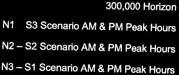
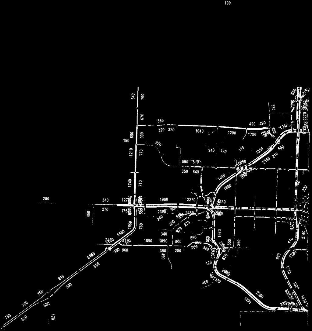
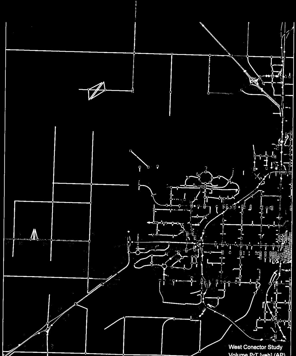
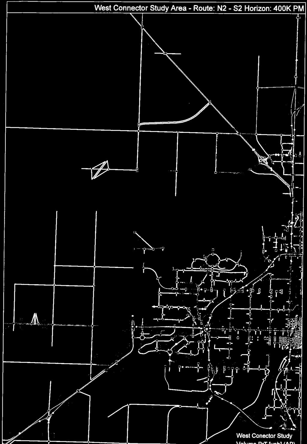
21 WEST CONNECTOR ROUTE FEASIBILITY STUDY REPORT 5.0 Traffic November 16, TRAFFIC With the identification of three north routes and three south routes, there are nine possible combination routes for the West Connector. In order to simplify the traffic analysis process, the project team selected three combination routes for traffic analysis, consisting of: Option 1: North Route 1 and South Route 3 Option 2: North Route 2 and South Route 2 Option 3: North Route 3 and South Route 1 Stantec received output data from the Saskatoon Region Traffic Demand Model representing each of these scenarios, plus a base scenario (no routes selected) at four population horizons. The population horizons within the model are based on the populations within the City of Saskatoon: 300,000 population horizon not including Saskatoon Freeway 400,000 population horizon not including Saskatoon Freeway 400,000 population horizon including Saskatoon Freeway 500,000 population horizon including Saskatoon Freeway Based on this data, Stantec prepared corridor volume projections for each of the scenarios comparing the projected traffic volumes for a selected corridor versus the base scenario. The factors included in route selection for the traffic model include: number of lanes link capacity per lane surface type travel time from origin to destination compared to alternative routes Based on the information received, the resulting traffic volumes for each corridor and each population horizon are shown in Figure 5.1. The figure shows the expected PM peak hour twoway link volumes on each segment if no changes are made to the network vs. if they are selected. Only the 300,000 and 400,000 population horizons are represented in this figure because these represent the timeframe applicable to the project (i.e. past the 400,000 population horizon, the Saskatoon Freeway will be in place which impacts multiple factors, and will require further analysis to see how things change). However, detailed traffic data for all horizons is included in Appendix D. 16
22 AVENUE P AVENUE H IDYLWYLD DRIVE IDYLWYLD DRIVE HWY. NO. 11 CIRCLE DRIVE Short Term Mid Term RANGE ROAD 3064 TOWNSHIP ROAD 380 Baseline If Selected Increase DALMENY ACCESS HWY. NO. 16 Short Term Mid Term RANGE ROAD 3060 Baseline If Selected Increase PROPOSED SASKATOON FREEWAY HWY. NO. 12 HWY. NO. 11 N AUCTION MART ROAD HWY. NO ST STREET PROPOSED SASKATOON FREEWAY Short Term Mid Term BEAM ROAD TOWNSHIP ROAD 372 Baseline If Selected Increase 51ST STREET MARQUIS DRIVE WANUSKEWIN DRIVE PROPO COMMUT Short Term Mid Term Baseline O1 O2 RANGE ROAD 3064 HWY. NO. 14 O3 NEAULT ROAD HODGSON ROAD 22ND STREET 11TH STREET Short Term Mid Term 33RD STREET Baseline If Selected Increase DIEFENBAKER DRIVE Short Term Mid Term FAIRLIGHT DRIVE VALLEY ROAD JUNOR AVENUE Baseline If Selected Increase CLAYPOOL DRIVE CIRCLE DRIVE 11TH STREET SPADINA 29TH STREET 22ND STREET CRESCENT 2ND AVENUE BROADWAY AVENUE CLARENCE AVENUE WARMAN ROAD SPADINA CRESCENT COLLEGE DRIVE 8TH STREET TAYLOR STREET CIRCLE DRIVE PRESTON AVENUE PRESTON AVENUE CENTRAL AVENUE BOYCHUK DRIVE LOWE ROAD ATTRIDG MCKERCHER DRIVE Short Term Mid Term Baseline If Selected Increase West Connector Route Alternatives Option 1: Includes N1 & S3 Option 2: Includes N2 & S2 Option 3: Includes N3 & S1 Scenarios Short Term: 300,000 Population Traffic Model (does not include Saskatoon Freeway) Mid Term: 400,000 Population Traffic Model (does not include Saskatoon Freeway) West Connector Route Feasibility Study Figure 5.1 Projected Traffic Volumes - PM Peak Hour
23 WEST CONNECTOR ROUTE FEASIBILITY STUDY REPORT 5.0 Traffic November 16, TRAFFIC VOLUME COMPARISON Route N1: Dalmeny Access The traffic volumes show a significant increase in traffic volumes, percentage wise, when this road is selected for the West Connector Route, in both the short and mid-term horizons. This indicates that drivers are more likely to use this route with certain upgrades; however, the overall volumes are still low and well within the capacity of an undivided two-lane roadway Route N2: Future Saskatoon Freeway No traffic volumes are projected on this corridor in the base condition because this roadway does not yet exist. If selected, this section would be built in advance of the completion of the complete Saskatoon Freeway. However, the traffic model suggests that this corridor will not attract high numbers of vehicles if selected and built Route N3: Beam Road This corridor is projected to see a decrease in traffic volumes if selected in the short term, and a significant increase in the mid-term. It s unclear whether this decrease is due to the margin of error in the traffic model or if users are actually avoiding the route. As with the Dalmeny Access, the overall projected traffic volumes are still within the capacity of an undivided two-lane roadway Central Corridor: Neault Road The implementation of any of the potential West Connector Routes results in increased traffic volumes on Neault Road, on average 37% in the short term and 44% in the mid-term. Between the three options, there is less than a 10% variance in traffic volumes, suggesting that traffic increases should be in the same vicinity, regardless of the route selected Route S1: 22 nd Street The traffic model shows little to no change in volumes when this road is selected for the West Connector Route, in both the short and mid-term horizons. This indicates either that drivers are no more likely to use this corridor once selected, or that the roadway is already at capacity and will not attract more users Route S2: 11 th Street The traffic volumes show a significant increase in traffic volumes, percentage wise, when this road is selected for the West Connector Route, in both the short and mid-term horizons. This indicates that drivers are likely to use this route with certain upgrades. 18
24 WEST CONNECTOR ROUTE FEASIBILITY STUDY REPORT 5.0 Traffic November 16, Route S3: Hodgson Road The traffic volumes are not projected to change significantly when this road is selected for the West Connector Route, in both the short and mid-term horizons. This suggests that drivers are not likely to use this route if selected, likely due to its distance from Saskatoon Traffic Summary In terms of traffic capacity, based on the traffic volumes and projections received, the existing capacity will not be exceeded on any of the segments proposed, for any options selected, meaning no additional lanes are required. There are many improvements, however, which would are likely to attract more traffic to specific routes, including surfacing upgrades, shoulder/lane widening, intersection treatments, lighting, etc. Based strictly on the traffic model data, there are no indications that any of the proposed routes attract significant traffic away from other roadways. Additionally, while some routes had very little effect on traffic, there was no clear route which was demonstrated as being superior to all other routes, strictly based on traffic model information. The fact that an obvious route is not clearly superior to the others may be due to a number of reasons, including due to the congestion being a network problem, which is not easily resolved by the upgrading of a single route; it may be due to errors, inaccuracies, or other items not accounted for in the modelling; or it may be due to a lack of origin-destination trips which all may affect the use of the proposed routes. 19
25 WEST CONNECTOR ROUTE FEASIBILITY STUDY REPORT 6.0 Improvements Required / Construction Costs November 16, IMPROVEMENTS REQUIRED / CONSTRUCTION COSTS At this preliminary level of route feasibility study, specific cost estimates for local improvements are not feasible. Through discussion with the clients, it was decided that planning level detail should be sufficient for this project. Based on this, Stantec has prepared an opinion of probable cost for each of the route options based on various improvements/upgrades assumed to be required, as discussed with the project team. A summary of the opinion of probable costs is provided below. A detailed breakdown of the associated costs presented below is included in Appendix E. 6.1 N1: DALMENY ACCESS This route is expected to require improvements such as shoulder widening and intersection improvements, including additional turning lanes and traffic signals at Highway 16. The probable cost for these improvements is approximately $5 M. 6.2 N2: SASKATOON FREEWAY This route would require the construction of two lanes of the future Saskatoon Freeway, i.e. half of the ultimate cross-section. Additional upgrades required would include turning lanes at both the Dalmeny Access and Highway 16 intersections, as well as traffic signals and intersection lighting at Highway 16. The probable cost for these improvements is approximately $8 M. Note: while an interchange is planned at the Saskatoon Freeway / Highway 16 junction, it would be constructed as part of that project, and not the West Connector project. 6.3 N3: BEAM ROAD If selected, this route would require paving and widening along the length of Beam Road. Additionally, turning lanes and intersection lighting would be constructed at Neault Road, as well as turning lanes at the Highway 16 intersection. The probable cost for these improvements is approximately $8 M. Note: an interchange is planned at the Beam Road / Highway 16 junction; however it will not be required as a part of the West Connector project. 20
26 WEST CONNECTOR ROUTE FEASIBILITY STUDY REPORT 6.0 Improvements Required / Construction Costs November 16, CENTRAL CORRIDOR: NEAULT ROAD Neault Road will require widening and repaving as a part of the West Connector Project, to enable primary weight trucks to travel this portion of roadway. The probable cost for these improvements is approximately $8 M. 6.5 S1: 22 ND STREET The existing 22 nd Street corridor is fully built out and no additional capacity can be installed without extensive work to the interchange at Circle Drive and 22 nd Street. Intersection improvements may be required but are unknown until further traffic study is completed. No cost is included at this point for any improvements. Further investigation is required. 6.6 S2: 11 TH STREET Several improvements would be required for this corridor if selected for the West Connector Route. From Highway 7 to Chappell Drive, 11 th Street would be widened and rebuilt. The existing 11 th Street bypass would be extended westward to Chappell Drive to reroute traffic away from the houses fronting 11 th Street south of the Viterra facility. Additionally, turning lanes and intersection lighting would be required at the Highway 7 intersection. The probable cost for these improvements is approximately $16 M. Property is likely required for the bypass realignment, which has not been included in this estimate. Further study will also be required to determine if upgrades are required to mitigate impacts to the Circle Drive interchange operations. 6.7 S3: HODGSON ROAD If selected, this route would require paving and widening along the length of Hodgson Road, which will likely require property aquisition. Additionally, turning lanes and intersection lighting would be installed at both the Highway 60 and Valley Road intersections. The probable cost for these improvements is approximately $9 M. 21
27 WEST CONNECTOR ROUTE FEASIBILITY STUDY REPORT 7.0 Conclusions November 16, CONCLUSIONS The purpose of this feasibility study was to provide potential options, constraints, and critical information pertaining to the potential future West Connector Route. The purpose of this study was not recommend, nor to select a preferred alternative for the route. Stantec has investigated the feasibility of the potential routes for the West Connector project and identified the potential constraints and challenges for each one, as well as determining the projected requirements and potential costs to upgrade each route. Based on the traffic modeling information, there is no conclusive evidence which demonstrates that the development of a West Connector Route would attract significant traffic as a potential option to traffic, during the short term horizons investigated. It is recommended that further traffic modeling and analysis be completed, particularly relating to origin-destination studies on traffic throughout the area. The feedback received from the public and stakeholders, however, supported the need for a West Connector Route. While the overall route preferences differed between the public and the stakeholders, the responses indicated that such a route would be used. Previous studies regarding the capacity of Circle Drive South indicated that there was sufficient traffic capacity for the long term projections, and that no additional southern bridge crossings would be required. Feedback from the stakeholders indicated that, while this may be true, restrictions on over-weight and over-dimensional loads placed restrictions on movements around Saskatoon. While the S3 option provided relief to some of these restrictions, it is recommended that further analysis be completed on potential routes for over-weight and overdimensional loads, to reduce restrictions and barriers on future routes. If this project should continue, it is expected that the next phase will include a functional planning study and further public consultation. This document and the corresponding display boards will provide a basis for this further study. 22
28 WEST CONNECTOR ROUTE FEASIBILITY STUDY REPORT Appendix A November 16, 2016 APPENDIX A Open House 1- Feedback
29 SASKATOON WEST CONNECTOR December 2 ND 2015 Open House Survey Feedback 1.0 NORTH ROUTES 1.1 GENERAL COMMENTS Confusion as to what the upgrades entail. o Interchanges (Particularly Hwy 14 & Neault, and Hwy 16 & Beam) o Paving o No. of lanes Objection to the routes being directly adjacent to existing residential 1.2 OPTION N1 (DALMENY ACCESS TO HWY 16) Safety concerns at Dalmeny Access & Hwy 16 due to lack of turning lanes on all approaches Fewest concerns with this route 1.3 OPTION N2 (PROPOSED SASKATOON FREEWAY) Sense that this is the only real solution, as the other ones only add to existing congestion. Some preference as it will be built anyway as part of Freeway route (saves building routes twice). Concerns about how 71 st integrates with new alignments. Seems to have primarily supportive comments (maybe due to lower residential impacts?) 1.4 OPTION N3 (BEAM ROAD) Requests to pave Beam Road regardless of whether it is chosen, as it will be continuous from the east side once NCP is completed. Supported because it connects majority of north industrial areas together. Not supported as it would direct traffic into highly congested areas. Concerns over the grid-lock that would result all along Marquis. bc w:\active\ \transportation\study\report\rpt_wcr_openhouse_1_feedback.docx 1.1
30 SASKATOON WEST CONNECTOR December 2 ND 2015 Open House Survey Feedback 2.0 SOUTH ROUTES 2.1 GENERAL COMMENTS Move dangerous goods out of city. Enforcement of truck traffic routes would be required, regardless of routes. o Sense that trucks will go the route they want regardless of allowances. Another route should be investigated: Either directly north or south of the CN yards. Request for investigation into alternate routes near Hodgson Road. o Directly along railway (north or south of yards) o Continued due west from Valley Road south of dog park o Diagonally across vacant land (minimize residential impacts) 2.2 OPTION S1 (22 ND STREET) Concerns that the improvements needed to make 22 nd Street a viable option are not feasible, and won t actually be implemented. Least direct opposition as it is already a major corridor, built for heavy traffic. No directly facing residential (unlike 11 th and Hodgson). Widening required regardless of outcome. Increased speed limit on 22 nd street. 2.3 OPTION S2 (11 TH STREET) Concerns with existing issues along 11 th becoming worse: o Safety (rail crossings, peds & cyclists, children crossing to schools, etc.) o Noise from trains and traffic. o Trains blocking traffic and emergency vehicles. o Difficulty as residential driveways directly access potential route. Increased traffic & dangerous goods next to residential. Hesitance from Montgomery area, as concerns expressed that plans were not followed through on CDS. Assumption that 11 th Street is already at capacity, and cannot handle more. Some support for S2 as logically, it is the most direct route off CDS to Hwy 7. Perceived as higher cost due to rebuilding the road Sense that Montgomery shares more than its fair burden for the sake of Saskatoon s growth. Montgomery Local Area Plan should have included this information. Montgomery residents assume S2 is all negative; improvements should be further discussed to show benefits to those impacted, instead of allowing assumptions to make decisions. bc w:\active\ \transportation\study\report\rpt_wcr_openhouse_1_feedback.docx 2.2
31 SASKATOON WEST CONNECTOR December 2 ND 2015 Open House Survey Feedback 2.4 OPTION S3 (HODGSON ROAD) Longest route feeling that it will not be used unless traffic is forced. Perception that it will be most expensive option as it is longest. Some support for S3 as it pulls some traffic out of Saskatoon core. Numerous comments indicating support for S3, as both S1 and S2 appear too busy already. Concerns with how multiple projects around Valley Road (COC, Garbage Dump, etc.) will have an impact on the roads within the vicinity. 3.0 MAIN CORRIDOR (NEAULT RD) Numerous comments indicating that it will need surface improvements and needs to be twinned. Numerous requests for grade separation at major intersections. Expectation that road will be used more as it will connect to north bridge along Beam Road. 4.0 GENERAL CONCERNS Some sense of urgency for any solution, regardless of which. Resistance to interim solutions, appearance of money wasted. o Keep costs down by utilizing future routes now. If there is a proposed freeway planned, why not just build it and be done? Sound attenuation/landscaping would be required for options affecting residential areas. More clarity requested for what improvements will entail, what road types, intersections, etc. Significant confusion between Freeway and WCR. Desire for Freeway route to be further west. If the problem is with congestion on Circle Drive/Idylwyld, why isn t the money spent on fixing those problems instead of this? o These solutions would be short and long term solutions then. 4.1 MEETING/FORMAT CONCERNS: Too Busy Speaker/presentation format may have helped to deliver main points of message. bc w:\active\ \transportation\study\report\rpt_wcr_openhouse_1_feedback.docx 4.3
32 WEST CONNECTOR ROUTE FEASIBILITY STUDY REPORT Appendix B November 16, 2016 APPENDIX B Open House 2 Display Boards
33 Welcome Saskatoon West Connector Route Information Session
34 Project Background Vision routes What we ve done


35 .7 O Y O.N N1 6 N2 AUCTION MART ROAD.1 H W Y O.N 6.1 LE DR IV E 29TH 22ND STREET A IN D A SP HWY. NO. 12 STREET STREET PROPOSED WAY N FREE SASKATOO RC CLAYPOOL DRIVE CI E 11TH IV 1.1 O.N Y W H MARQUIS DRI 71ST STREET 51ST STREET IN DR IVE SKEW N3 BEAM ROAD TOWNSHIP ROAD RD STREET S1 CI RC DR WARM AN RO AD WANU NT CE ES RANGE ROAD 3060 JUNOR AVENUE DRIVE IDYLWYLD DRIVE IDYLWYLD CIRCLE DR TAYLOR STREET 8TH STRE COLLEG DRIVE CR A DIN SPA CLARENCE AVENUE DIEFENBAKER DRIVE E IV DR 22ND STREET T H G LI IR FA 11TH STREET S2 LE AVENUE P DALMENY ACCESS NEAULT ROAD TOWNSHIP ROAD 380 HWY. NO. 14 S3 2ND AVE NUE BROADWAY AVENUE SA W RANGE ROAD 3064 H N AVENUE H NT AY HODGSON ROAD SCE CRE SK P AT RO OO PO N SED FR EE W MERRIL SCHOOL ROAD VALLEY ROAD RANGE ROAD 3064 Route Alternatives Y. W H PROPOSED SASKATOON FREEWAY


36 22ND STREET HWY. NO. 14 AVENUE P 11TH STR PROP SASKATOO RANGE ROAD 3060 HWY. NO. 16 DALMENY ACCESS AUCTION MART ROAD HWY. NO. 16 BEAM ROAD TOWNSHIP ROAD 372 JUNOR AVENUE CLAYPOOL DRIVE CIRCLE DRIVE 33RD STREET 29 DIEFENBAKER DRIVE NEAULT ROAD 22 FAIRLIGHT DRIVE 11TH STREET CR SPADINA CIRCLE DRIVE VALLEY ROAD TOWNSHIP ROAD 380 N1 SASKATOON FREEWAY PROPOSED HODGSON ROAD RANGE ROAD 3064 RANGE ROAD 3064 NO. 7 What We Heard: Support for this route Comments on quality of road (narrow shoulders, intersection problems) Concerns about dangerous goods hauled near residences Additional turning lanes at Highway 16 Shoulder widening (An interchange Estimated Cost: $5-6M Route N1: Dalmeny Access
37 22ND STREET HWY. NO. 14 AVENUE P 11TH STR PROP SASKATOO RANGE ROAD 3060 HWY. NO. 16 DALMENY ACCESS AUCTION MART ROAD HWY. NO. 16 BEAM ROAD TOWNSHIP ROAD 372 JUNOR AVENUE CLAYPOOL DRIVE CIRCLE DRIVE 33RD STREET 29 DIEFENBAKER DRIVE NEAULT ROAD 22 FAIRLIGHT DRIVE 11TH STREET CR SPADINA CIRCLE DRIVE VALLEY ROAD TOWNSHIP ROAD 380 SASKATOON FREEWAY PROPOSED HODGSON ROAD RANGE ROAD 3064 RANGE ROAD 3064 NO. 7 What We Heard: Support for this route of time, not building two different routes New construction of roadway (two lanes i.e. half ) Highway 16 junctions Intersection lighting (An interchange is at Highway 16 ) Estimated Cost: $10-12M N2 Route N2: Saskatoon Freeway
38 22ND STREET HWY. NO. 14 AVENUE P 11TH STR PROP SASKATOO RANGE ROAD 3060 HWY. NO. 16 DALMENY ACCESS AUCTION MART ROAD HWY. NO. 16 BEAM ROAD TOWNSHIP ROAD 372 JUNOR AVENUE CLAYPOOL DRIVE CIRCLE DRIVE 33RD STREET 29 DIEFENBAKER DRIVE NEAULT ROAD 22 FAIRLIGHT DRIVE 11TH STREET CR SPADINA CIRCLE DRIVE VALLEY ROAD TOWNSHIP ROAD 380 SASKATOON FREEWAY PROPOSED HODGSON ROAD RANGE ROAD 3064 RANGE ROAD 3064 NO. 7 What We Heard: Some support for this option (closer to the City, north industrial areas) and some resistance (too Concerns about existing road conditions shoulders) intersection Turning lanes at Highway 16 intersection (An interchange is ) Estimated Cost: $7-10M N3 Route N3: Beam Road
39 22ND STREET HWY. NO. 14 AVENUE P 11TH STR PROP SASKATOO RANGE ROAD 3060 HWY. NO. 16 DALMENY ACCESS AUCTION MART ROAD HWY. NO. 16 BEAM ROAD TOWNSHIP ROAD 372 JUNOR AVENUE CLAYPOOL DRIVE CIRCLE DRIVE 33RD STREET 29 DIEFENBAKER DRIVE NEAULT ROAD 22 FAIRLIGHT DRIVE 11TH STREET CR SPADINA CIRCLE DRIVE VALLEY ROAD TOWNSHIP ROAD 380 SASKATOON FREEWAY PROPOSED HODGSON ROAD RANGE ROAD 3064 RANGE ROAD 3064 NO. 7 What We Heard: Concerns about existing road conditions (will more signals be installed?) Widen shoulders Estimated Cost: $7-10M Central Corridor: Neault Road
40 22ND STREET HWY. NO. 14 AVENUE P 11TH STR PROP SASKATOO RANGE ROAD 3060 HWY. NO. 16 DALMENY ACCESS AUCTION MART ROAD HWY. NO. 16 BEAM ROAD TOWNSHIP ROAD 372 JUNOR AVENUE CLAYPOOL DRIVE CIRCLE DRIVE 33RD STREET 29 DIEFENBAKER DRIVE NEAULT ROAD 22 FAIRLIGHT DRIVE 11TH STREET CR SPADINA CIRCLE DRIVE VALLEY ROAD TOWNSHIP ROAD 380 SASKATOON FREEWAY PROPOSED HODGSON ROAD RANGE ROAD 3064 RANGE ROAD 3064 NO. 7 What We Heard: Existing roadway is fully built out, no additional capacity can be installed study is completed) Estimated Cost: $6-8M S1 Route S1: 22nd Street
41 22ND STREET HWY. NO. 14 AVENUE P 11TH STR PROP SASKATOO RANGE ROAD 3060 HWY. NO. 16 DALMENY ACCESS AUCTION MART ROAD HWY. NO. 16 BEAM ROAD TOWNSHIP ROAD 372 JUNOR AVENUE CLAYPOOL DRIVE CIRCLE DRIVE 33RD STREET 29 DIEFENBAKER DRIVE NEAULT ROAD 22 FAIRLIGHT DRIVE 11TH STREET CR SPADINA CIRCLE DRIVE VALLEY ROAD TOWNSHIP ROAD 380 SASKATOON FREEWAY PROPOSED HODGSON ROAD RANGE ROAD 3064 RANGE ROAD 3064 NO. 7 What We Heard: residents due to trains upgrades Some support for this as the shortest route construct sound wall for this portion Turning lanes and lighting at Highway 7 intersection Property may be required for realignment interchange operations) Estimated Cost: $15-20M S2 Route S2: 11th Street
42 22ND STREET HWY. NO. 14 AVENUE P 11TH STR PROP SASKATOO RANGE ROAD 3060 HWY. NO. 16 AUCTION MART ROAD HWY. NO. 16 BEAM ROAD TOWNSHIP ROAD 372 JUNOR AVENUE CLAYPOOL DRIVE CIRCLE DRIVE 33RD STREET 29 DIEFENBAKER DRIVE 22 FAIRLIGHT DRIVE 11TH STREET CR SPADINA CIRCLE DRIVE VALLEY ROAD TOWNSHIP ROAD 380 DALMENY ACCESS SASKATOON FREEWAY PROPOSED NEAULT ROAD HODGSON ROAD RANGE ROAD 3064 RANGE ROAD 3064 NO. 7 What We Heard: with some users Turning lanes and lighting at Highway 60 intersection Turning lanes and lighting at intersection of Pave roadway (two lanes with wide shoulders) Property will be required for widening Estimated Cost: $10-14M S3 Route S3: Hodgson Road / Valley Road
43 Next Steps Moving forward, we will: This concludes the public consultation process for this project.


44 Thank You For Attending! View more information at:
45 WEST CONNECTOR ROUTE FEASIBILITY STUDY REPORT Appendix C November 16, 2016 APPENDIX C Key Stake Holder Meeting - Feedback
46 Memo To: Geoff Meinert, Ministry of Highways From: Josh Richer, Stantec Consulting Don Cook, City of Saskatoon Bryce Hunter, Stantec Consulting Rebecca Row, RM of Corman Park File: Saskatoon West Connector Route Date: April 25, 2016 Reference: West Connector Route Stakeholder Meeting Summary As part of the Saskatoon West Connector Route Feasibility Study, a stakeholder meeting was held on April 6, This memorandum was prepared to provide a summary of the discussions held, and results of the meeting. 1. BACKGROUND The purpose of the meeting was to solicit feedback from key stakeholders who may, or whose operations or members may, be affected by the project. As per discussion between the project team, key stakeholders were identified, and invitations were sent to the following: PCS Cory Moosomin First Nation North Saskatoon Business Association Saskatoon Airport Authority Saskatoon Trucking Association The attendees at the April 6 meeting were as follows: Project Team: Josh Richer Stantec Lindsay Haskins Stantec Erin Medforth Stantec Doug Fast Fast Consulting Stakeholders: David Weger - PCS Cory (Potash Corporation of Saskatchewan) David Gauthier SREDA (Saskatoon Regional Economic Development Auth.) Keith Moen - NSBA (North Saskatoon Business Association) Harvey McClelland Saskatchewan Trucking Associate & Turner Transport Lory Sproxton Saskatoon Airport Authority Brent Marcoux AFI Dist Group Brock Girling Saskatchewan Trucking Associate & Q-Line Trucking Steve Peever Q-Line Trucking A brief presentation was given at the start of the meeting in order to provide attendants with a background of the project and findings to date. An informal discussion on the project, along with concerns and suggestions followed, and is described further below.
47 April 25, 2016 Page 2 of 7 2. GENERAL COMMENTS AND CONCERNS In general terms, all attendees saw the need for the project, but there was concern with a variety of things surrounding the project, which are described more within this section. 2.1 Planning One of the primary concerns was the lack of a transportation master plan for the City and surrounding area. While it was discussed that this project may allow for partial offsetting of the Saskatoon Freeway project, the general consensus was that the Freeway should be part of a master plan, with a high-level timeline established, which would then give more basis for a project such as this. While this project may be needed at the current time, most attendees indicated they would rather see a Freeway within five years or so, which would then minimize the need for this project. Concerns were expressed regarding the relatively unknown status of the Saskatoon Freeway, and the assumption that there are likely developments near the proposed route which are currently on hold, until more is known, and commitments are made with regards to the project. The recommendation was that securing and constructing a small portion of the project (as in Option N2) would solidify the location, and provide developers with certainty, buy-in, and comfort with both the Saskatoon Freeway and the West Connector projects. 2.2 Location & Speed Regarding the location of the proposed route, there was agreement that any improvements should focus on bypassing the City as much as feasible. The general location of the proposed route was seen as acceptable, meeting the needs of a variety of users. In addition to the general location of the project, discussion was had on the individual routes proposed in the presentation, specifically relating to the fact that certain routes are significantly shorter than other routes. There was consensus that the primary objective from a trucking perspective, would not be to have a shorter route, but would be to have a more free-flow route with higher speeds. For example, given the option of travelling down existing 22 nd Street (proposed Option S1), or heading significantly further to Hodgson Road (proposed Option S3), there was unanimous agreement that Hodgson Road would be the preference, provided it was posted at km/h, and was designed to handle the larger turning radii typically associated with heavier truck traffic. Suggestions were made to the effect that, should this route be considered a route for truck traffic, priority should be placed on providing a primarily free-flow route around the outskirts of the City, as trucking through City streets can be extremely challenging. 2.3 Load Considerations Multiple concerns were raised with potential use of the routes suggested. One of the primary concerns is not getting around the city due to traffic; it s getting through the city with large or heavy loads. Currently, delivering overweight and oversized farm equipment from northwest Saskatoon (where significant manufacturing occurs) to southeast Saskatoon, it may not be possible to proceed through Saskatoon, even with Circle Drive South. Multiple attendees indicated that multiple trucking companies repeatedly haul such shipments north to St. Louis, or south to Outlook, to cross the river, before returning to the other side of Saskatoon.
48 April 25, 2016 Page 3 of 7 Provincial Highways 16 and 14 are currently both listed as Provincial Highways on which B-trains can operate at 63,500 kg, and this route could serve as a portion of the north-south connection between these routes, and around a portion of the City. 3. INTER-RELATIONSHIP WITH SASKATOON FREEWAY 3.1 Timelines The timelines and location of the proposed Saskatoon Freeway were brought up numerous times during the meeting, as there is a relationship between these two projects. As indicated above, while the need for this project is evident at the current time, most attendees indicated they would be willing to wait, if the Saskatoon Freeway was to be constructed within the next five years of so, as opposed to seeing this project proceed. This project is primarily seen as a temporary fix for some of the current issues encountered, and there was consensus between attendees that they would prefer to see the full project built (Saskatoon Freeway), as opposed to a temporary fix. 3.2 Relationship with Circle Drive South Based on a recent study regarding future alignments of the south/southwest leg of the Saskatoon Freeway, the Ministry has determined not to proceed with any further work regarding this portion of the freeway at this time. As indicated at the meeting by one of the attendees who was involved in the stakeholder consultations for the Saskatoon Freeway, the decision to not proceed with further planning of this route was due to the understanding that Circle Drive South would have the traffic capacity to serve the City and region for the foreseeable future. While it may be true that Circle Drive South has sufficient capacity, a concern brought up by multiple stakeholders was the fact that access onto Circle Drive South, for any wide or overweight loads, is extremely difficult if not impossible. As alluded to in Section 2.3, the lack of oversized and overweight corridors through the City diverts substantial traffic around the City, even for inter-city deliveries. Based on this, there was consensus at the meeting that the bypass route should place significant concern on providing an access for overweight and oversized traffic to Circle Drive South. 4. DISCUSSION ON SPECIFIC ROUTES 4.1 Option N1 Dalmeny Access (Grid 684) Dalmeny Road is currently a paved 2-lane roadway, and many attendees indicated they (or their members) currently use this road. Through discussion, it was indicated that this option would require shoulder widening to make it a truly viable alternative, and, as it has the highest number of residences adjacent to the roadway of the three options investigated, it was understood that there could be significant cost to this. While the potential for hauling hazardous goods along this route has not been discussed in detail, this was also indicated as a concern, due to the residences.
49 April 25, 2016 Page 4 of Option N2 Saskatoon Freeway Option N2 would include construction of one portion of the future Saskatoon Freeway, between Highway 16 and Dalmeny Access (anticipated to be 2 of the 4 lanes). This option was seen as the preferred option for a number of reasons. The business development representatives indicated that their understanding is that there is significant uncertainty about the Saskatoon Freeway project, and that some development and business are holding off on future plans until more is known. From a business perspective, the establishment of one portion of the route would give certainty to the location and allow business and development to resume in the northwest area, as well as show commitment and good faith to the overall project. This alternative was also seen as the most preferred by other attendees, as it provides a best of both worlds alternative regarding its proximity to the city, and will allow the incorporation of requirements for overweight and oversize loads such as larger turning radii, taller structures, underground lines, etc. This route also appears to disrupt a minimal number of residences, and with minimal residences in the general vicinity, this route also becomes a better candidate for a dangerous goods route. 4.3 Option N3 Beam Road Option N3 would include upgrading Beam Road to a paved 2 lane roadway. This alternative was less preferred than the N2 option. It was understood that the Beam Road alternative may serve the short term needs best, there was concern over the need for an interchange at Beam Road / Marquis Drive and Highway 16 and the timelines required to complete such work. There were also minor concerns from the Saskatoon Airport Authority that this route borders on the current northern extent of the airport, and there is concern over future needs of the airport, and the long term prospects of the roadway. 4.4 Main Corridor Neault Road Regarding the use of Neault Road as the main corridor for the West Connector Route, there was general acceptance of the corridor proposed. While there were again questions regarding the timing of the Saskatoon Freeway, and discussion regarding the construction of the west portion of the freeway instead of this route, there was acceptance of this alignment as a temporary solution prior to the long term solution being in place. 4.5 Option S1 22 nd Street West Through discussion with the attendees at the meeting, it became quickly apparent that this option was not seen as a viable option by the attendees, particularly for any alternative that is to serve commercial truck traffic. Through discussion, it was understood that commercial truck traffic will typically prefer routes which provide higher speed, less congestion, and free flow options. The assumption that truck traffic would use 22 nd Street West, as it provides the shorted access onto Circle Drive was quickly dismissed, and it was indicated that a substantially longer route would not dissuade truck traffic, as long as it provided more free flow to the route.
, due to the interchange configuration, both the on-ramp and off-ramp pass through a structure with limited space in all directions.")

50 April 25, 2016 Page 5 of 7 Another concern which was raised was restrictions at the existing interchange configuration at Circle Drive and 22 nd Street West, and the restrictions placed on oversized loads. As shown in Figure 1 and Figure 2 (below), due to the interchange configuration, both the on-ramp and off-ramp pass through a structure with limited space in all directions. This was raised as a concern, as the structure is not accessible by oversized loads, which drastically limits the use of this option as a feasible route. Figure 1: Circle Drive On-ramp from 22nd Figure 2: Circle Drive Off-Ramp at 22nd Street Street In addition to the restrictions above, accessing Circle Drive South from this location, which is one of the primary connections this project would provide, is further complicated by the fact that four additional underpasses are encountered prior to accessing the Circle Drive South bridge. 4.6 OPTION S2 11 th Street West The use of 11 th Street West as part of the West Connector Route was received with mixed reactions. On one hand, this route could provide a quick connection from Highway 7 onto Circle Drive, but there are multiple issues with each aspect of this route. The intersection of 11 th Street with both Highway 7 and Circle Drive are restrictive. At Highway 7, concerns over how the intersection would be upgraded, and how traffic and turning requirements could be improved were raised. At Circle Drive, the presence of three separate rail crossings between 11 th Street and Circle Drive was a significant concern with the route. If the purpose of the connector route is to provide improved connections around the City, this should be seen as a major restriction. Other concerns raised included realigning a section of 11 th Street, the restrictions placed due the Viterra plant, the required rebuilding of the west portion of the road, and the residential neighbourhood adjacent to the route, which would likely place restrictions on dangerous goods. These issues raised the question of the feasibility of this option, along with the public pressure likely to be encountered. The general consensus regarding this alternative was that while it may work from a traffic perspective, the concerns indicated above limit the feasibility of this option, and it was generally disregarded as a viable option for larger truck traffic and dangerous goods.
51 April 25, 2016 Page 6 of Option S3 Hodgson Road / Valley Road The Hodgson Road / Valley Road option was discussed in length with the stakeholders, and the route was received positively by the group. While this route is the longest option, it has numerous characteristics which outweigh other options. Highway No. 7 is listed as a provincial high-load corridor route. The ability to connect this route directly with Circle Drive South was seen a legitimate benefit to this option. As indicated earlier, it is difficult to access Circle Drive South with oversized loads, and this option provides a direct connection. Additionally, the east/west lanes on Highway No. 7 diverge horizontally at its junction with Highway No. 60 (which would form part of this route), and provides improved benefits for traffic at this intersection. Contrary to 11 th Street West, this alternative has only one at-grade rail crossing and one grade separated rail crossing with Valley Road passing above the railway. For traffic onto and off of the Circle Drive South river crossing, this route contains no underpasses, placing far fewer restrictions on oversized loads, allowing a direct connection with Circle Drive and across the river. This option also contains less traffic and fewer traffic controls, which allows for increased free flow traffic. Hodgson Road is currently a rural grid road, with a speed limit of 80 km/hr. Valley Road (Highway 762) is a provincial highway with a speed limit of 90 km/hr. Highway 60 is a provincial highway with a speed limit of 100 km/hr. The higher speed of these roadways is especially attractive to commercial truck traffic, and it was indicated that, if the south route maintained an 80 km/hr speed limit, this route would be ideal as a truck route. As this option is located further away from established neighbourhoods, it would better serve as a dangerous goods route, as well. The stakeholders requested that additional investigation be completed into routing the southern option diagonally off Valley Road through the open land, as it would push traffic further yet from residences along Valley Road. This alternative was further validated through examination of utilities; there are a number of utilities within the ditches of Hodgson Road, many of which would likely require relocation, should the route proceed down the existing Hodgson Road alignment. 5. FUTURE CONSIDERATIONS 5.1 Saskatoon Freeway As indicated in Section 3.2, the Ministry has determined not to pursue a south/southwest leg for the Saskatoon Freeway at the current time. The approved Saskatoon Freeway route currently terminates near its intersection with Highway 14. Throughout the discussion, there was consensus that there may be a feasible and more preferred connection for the Saskatoon Freeway. Should the southern (S3) option be selected for the West Connector Route, it would appear logical to connect the southwest leg of the Freeway to the intersection of Highway 60/Highway 7, which could then connect to the south leg of the West Connector Route. Doing so would provide a southern connection onto Circle Drive South and complete the Saskatoon Freeway connectivity with a southern leg.


52 April 25, 2016 Page 7 of 7 6. CLOSING As described above, the conversation with stakeholders provided insight into business and commercial trucking operations, as well as the challenges which currently exist. The need for the route was confirmed through this meeting with the various stakeholders, and they requested that priority be placed on oversized and overweight considerations for any route selected. There was also a recommendation that further investigation be completed regarding the timing of this project, as well as the Saskatoon Freeway project, to provide more certainty to either project. In summary, the stakeholders had unanimous agreement that the N2 (Saskatoon Freeway) and S3 (Hodgson Road) alternatives were preferred for the West Connector Route. STANTEC CONSULTING LTD. Josh Richer, P.Eng. Bryce Hunter, P.Eng. Transportation Engineer Project Manager Phone: Phone: josh.richer@stantec.com bryce.hunter@stantec.com c. Tom Mercer, P.Eng., Project Director
53 WEST CONNECTOR ROUTE FEASIBILITY STUDY REPORT Appendix D November 16, 2016 APPENDIX D Traffic Data
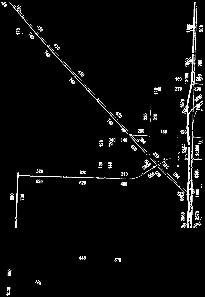
54
55
56
57
58
59
60
61
62
63
64
65
66
67
68
69
70

71
72

73

74

75

76

77
78

79
80

81
82
83


84


85
86


87
88

89
90
91

92

93

94

95
96


97


98

99

100

101
102

103


104

105

106
107

108
109

110
111


112
113
114

115

116

117

118

119
120

121
122

123

124

125
126

127

128
129
130
131
132
133
134
135
136
137 WEST CONNECTOR ROUTE FEASIBILITY STUDY REPORT Appendix E November 16, 2016 APPENDIX E Probable Costs
138 West Connector Route Preliminary Opinion of Probable Cost Costs below are provided as a preliminary opinion of probable cost. All costs include 30% contingency cost, and are rounded up to the nearest $10,000. OPTION N1 Total: $ 4,500,000 Intersection Improvements (Dalmeny Access & Highway 16) Eastbound Acceleration Lane $ 330,000 Southbound Acceleration Lane $ 330,000 Northbound Flare $ 260,000 Traffic Lights $ 330,000 Shoulder Widening 2 Paved Shoulder Lanes km Sub-Total: $ 3,230,000 Widening $ 1,680,000 Sub-base $ 290,000 Base $ 360,000 Paving $ 900,000 OPTION N2 Total: $ 8,000,000 New Construction of Roadway 2 Lane Paved Highway km $ 4,550,000 Shoulder Widening 2 Paved Shoulder Lanes - 2 km Sub-Total: $ 1,500,000 Widening $ 780,000 Sub-base $ 130,000 Base $ 170,000 Paving $ 420,000 Intersection Improvements (N2 & Highway 16) Westbound Acceleration Lane $ 330,000 Eastbound Acceleration Lane $ 330,000 Westbound Right Turn Lane $ 260,000 Intersection Lighting $ 70,000 Traffic Lights $ 330,000 Intersection Improvements (N2 and Dalmeny Access) Southbound Channelization $ 330,000 Northbound Flare $ 260,000 Intersection Lighting $ 40,000 *all values include a 30% contingency 1 of 4 6/29/2016
139 West Connector Route Preliminary Opinion of Probable Cost OPTION N3 Total: $ 7,700,000 Paving of Beam Road 2 Lane Paved Highway km Sub-Total: $ 6,990,000 Surface Preparation $ 70,000 Widening $ 1,800,000 Sub-base $ 1,060,000 Base $ 1,210,000 Paving $ 2,850,000 Intersection Improvements (Beam Road and Dalmeny Access) Southbound Channelization $ 330,000 Northbound Flare $ 260,000 Intersection Lighting $ 40,000 Intersection Improvements (Beam Road and Dalmeny Access) Advances the need for additional intersection improvements or potential interchange. $ Unknown CENTRAL CORRIDOR Total: $ 7,700,000 Re-Paving of Neault Road - Upgrading to Primary Highway Highway 7 to Whelan Road km Sub-Total: $ 7,650,000 Surface Preparation $ 130,000 Widening $ 1,950,000 Sub-base $ 1,150,000 Base $ 1,320,000 Paving $ 3,100,000 OPTION S1 Total: $ - 22nd Street West Route can be used in its existing state. Further analysis required to investigate the feasibility of upgrading this section. $ Unknown *all values include a 30% contingency 2 of 4 6/29/2016
140 West Connector Route Preliminary Opinion of Probable Cost Option S2 Total: $ 16,400,000 Upgrading of 11th Street West Chappell Drive to Highway km Sub-Total: $ 3,240,000 Surface Preparation $ 70,000 Widening $ 820,000 Sub-base $ 490,000 Base $ 560,000 Paving $ 1,300,000 Realignment of 11th Street West 11th Street Bypass to Chappell Drive km $ 10,400,000 Sound Wall 11th Street Bypass to Chappell Drive km $ 1,950,000 Intersection Improvements (11th Street & Highway 7) Southbound Acceleration Lane $ 330,000 Northbound Acceleration Lane $ 330,000 Upgrade Intersection Lighting $ 70,000 Intersection of 11th Street West and Circle Drive Further analysis required to investigate the feasibility of upgrading this section. $ Unknown Property Acquisition Further investigation required into property requirements for 11th Street realignment. $ Unknown *all values include a 30% contingency 3 of 4 6/29/2016
 Northbound Channelization $ 330,000 Southbound Flare $ 260,000 Intersection Lighting $ 40,000 Upgrading of")
141 West Connector Route Preliminary Opinion of Probable Cost Option S3 Total: $ 8,900,000 Intersection Improvements (Valley Road & Hodgson Road) Northbound Channelization $ 330,000 Southbound Flare $ 260,000 Intersection Lighting $ 40,000 Intersection Improvements (Hodgson Road & Highway 60) Northbound Channelization $ 330,000 Southbound Flare $ 260,000 Intersection Lighting $ 40,000 Upgrading of Hodgson Road 2 Lane Paved Highway km Sub-Total: $ 7,590,000 Surface Preparation $ 70,000 Widening $ 1,950,000 Sub-base $ 1,150,000 Base $ 1,320,000 Paving $ 3,100,000 Property Acquisition Further investigation required into property requirements along Hodgson road for widening. $ Unknown *all values include a 30% contingency 4 of 4 6/29/2016
Longmont to Boulder Regional Trail Jay Road Connection DRAFT FINAL REPORT
 Longmont to Boulder Regional Trail Jay Road Connection DRAFT FINAL REPORT December 2018 Project Summary Boulder County, Colorado, in partnership with the City of Boulder, is evaluating options for multi-use
Glasgow Street Traffic Review
 Glasgow Street Traffic Review Recommendation That the Standing Policy Committee on Transportation recommend to City Council: 1. That the Administration proceed with removing the pinch points installed
Engagement Summary Report. Trans-Canada Highway 1 RW Bruhn Bridge Replacement Project. Community Engagement November 15, 2016 to January 15, 2017
 Trans-Canada Highway 1 RW Bruhn Bridge Replacement Project Community Engagement November 15, 2016 to January 15, 2017 Engagement Summary Report February 2017 Prepared by Kirk & Co. Consulting Ltd. Trans-Canada
Lake Erie Commerce Center Traffic Analysis
 LOCATION: East of NYS Route 5 at Bayview Road Town of Hamburg Erie County, New York PREPARED BY: Wendel Companies 140 John James Audubon Parkway Suite 200 Amherst, New York 14228 January 2012 i ii Table
Project Deliverable 4.1.3d Individual City Report - City of La Verne
 Pomona Valley ITS Project Project Deliverable 4.1.3d Individual City Report - City of La Verne Prepared by: April 19, 2002 099017000.1 Copyright 2002, Kimley-Horn and Associates, Inc TABLE OF CONTENTS
PUBLIC INFORMATION SESSION #2
 Highway 16, Highway 779 to Kapasiwin Road, Planning Study PUBLIC INFORMATION SESSION #2 Wednesday June 20, 2012 4 to 8 pm HIGHWAY 16 Highway 779 to Kapasiwin Road Functional Planning Study Blueberry Community
Stage 2 ION: Light Rail Transit (LRT) from Kitchener to Cambridge
 from Kitchener to Cambridge") Stage 2 ION: Light Rail Transit (LRT) from Kitchener to Cambridge Public Consultation Centre (PCC) No. 3 Please Sign-in Cambridge City Hall November 21, 2017 2:00 to 8:00pm Preston Memorial Auditorium
Stage 2 ION: Light Rail Transit (LRT) from Kitchener to Cambridge Public Consultation Centre (PCC) No. 3 Please Sign-in Cambridge City Hall November 21, 2017 2:00 to 8:00pm Preston Memorial Auditorium
FNORTHWEST ARKANSAS WESTERN BELTWAY FEASIBILITY STUDY
 FNORTHWEST ARKANSAS WESTERN BELTWAY FEASIBILITY STUDY EXECUTIVE SUMMARY The 2030 Northwest Arkansas Regional Transportation Plan developed by the Northwest Arkansas Regional Planning Commission (NWARPC)
PSP 75 Lancefield Road. Northern Jacksons Creek Crossing Supplementary Information
 PSP 75 Lancefield Road Northern Jacksons Creek Crossing Supplementary Information September 2017 The northern crossing of Jacksons Creek proposed within the Lancefield Road PSP is a key part of the ultimate
HDR itrans Consulting Inc. 100 York Blvd., Suite 300 Richmond Hill, ON L4B 1J8 Tel: (905) Fax: (905)
 Fax: (905)") !" # $ !" # $ Consulting Inc. 100 York Blvd., Suite 300 Richmond Hill, ON L4B 1J8 Tel: (905) 882-4100 Fax: (905) 882-1557 www.itransconsulting.com November 2009 %&'('$&$ 1. West Brampton Road Network...
!" # $ !" # $ Consulting Inc. 100 York Blvd., Suite 300 Richmond Hill, ON L4B 1J8 Tel: (905) 882-4100 Fax: (905) 882-1557 www.itransconsulting.com November 2009 %&'('$&$ 1. West Brampton Road Network...
Memorandum. Roger Millar, Secretary of Transportation. Date: April 5, Interstate 90 Operations and Mercer Island Mobility
 Memorandum To: From: The Honorable Dow Constantine, King County Executive; The Honorable Ed Murray, City of Seattle Mayor; The Honorable Bruce Bassett, City of Mercer Island Mayor; The Honorable John Stokes,
9 CONSTRUCTION OF BATHURST STREET FROM GREEN LANE WEST TO SOUTH OF HIGHWAY 11, TOWN OF EAST GWILLIMBURY AND TOWNSHIP OF KING
 Clause No. 9 in Report No. 9 of Committee of the Whole was adopted, without amendment, by the Council of The Regional Municipality of York at its meeting held on May 15, 2014. 9 CONSTRUCTION OF BATHURST
3. COLTA / HUGA CONNECTIONS - PRELIMINARY
 9 3. COLTA / HUGA CONNECTIONS - PRELIMINARY 3.1 COLTA The Chain of Lakes Trail Association (COLTA) trail, formerly identified as the Chester Spur Line, was completed and opened for use in June 2011. The
A. CONCLUSIONS OF THE FGEIS
 Chapter 11: Traffic and Parking A. CONCLUSIONS OF THE FGEIS The FGEIS found that the Approved Plan will generate a substantial volume of vehicular and pedestrian activity, including an estimated 1,300
AGENDA ITEM 5 D WAKULLA ENVIRONMENTAL INSTITUTE (WEI) TRAIL FEASIBILITY STUDY
 TRAIL FEASIBILITY STUDY") March 19, 2018 AGENDA ITEM 5 D WAKULLA ENVIRONMENTAL INSTITUTE (WEI) TRAIL FEASIBILITY STUDY TYPE OF ITEM: Action STATEMENT OF ISSUE The Wakulla Environmental Institute (WEI) Trail is one of several trails
March 19, 2018 AGENDA ITEM 5 D WAKULLA ENVIRONMENTAL INSTITUTE (WEI) TRAIL FEASIBILITY STUDY TYPE OF ITEM: Action STATEMENT OF ISSUE The Wakulla Environmental Institute (WEI) Trail is one of several trails
1.2 Corridor History and Current Characteristics
 SECTION 1 Description and Background of Study Area 1.1 Introduction This preliminary engineering report was prepared for the Alaska Department of Transportation and Public Facilities (ADOT&PF). It is part
5.1 Traffic and Transportation
 5.1 When it opens in 2009, the Bellevue Nickel Improvement Project will increase the number of vehicles able to travel through the study area, improve travel speeds, and improve safety by reducing the
12, 14 and 16 York Street - Amendments to Section 16 Agreement and Road Closure Authorization
 REPORT FOR ACTION 12, 14 and 16 York Street - Amendments to Section 16 Agreement and Road Closure Authorization Date: April 27, 2018 To: Toronto and East York Community Council From: Senior Strategic Director,
US 380 FEASIBILITY STUDY
 US 380 FEASIBILITY STUDY Denton County CSJ(s): 0135-10-061, 0135-10-062 Public Meeting(s): January 15 & 22, 2019 WELCOME US 380 Denton County Feasibility Study DALLAS DISTRICT PUBLIC MEETING January 15
MEMORANDUM. Lynn Hayes LSA Associates, Inc.
 MEMORANDUM To: Lynn Hayes LSA Associates, Inc. Date: May 5, 217 From: Zawwar Saiyed, P.E., Senior Transportation Engineer Justin Tucker, Transportation Engineer I Linscott, Law & Greenspan, Engineers LLG
United States Department of the Interior National Park Service. Boundary Expansion Listed in National Register January 11, 2017
 NPS Form 10900-a (Rev. 8/2002) OMB No. 10240018 United States Department of the Interior National Park Service Boundary Expansion Listed in National Register January 11, 2017 National Register of Historic
Sunshine Coast Airport Master Plan September 2007
 Sunshine Coast Airport Master Plan September 2007 Contents CONTENTS... I ACKNOWLEDGEMENT... II DISCLAIMER... III 1 EXECUTIVE SUMMARY...IV 1 INTRODUCTION... 1 2 AVIATION DEMAND FORECAST... 5 3 AIRCRAFT
Stage 2 - November 2017 Survey and Map Comments (verbatim)
") Stage 2 - November 2017 Survey and Map Comments (verbatim) Identifying information removed to meet Freedom of Information and Protection of Privacy Act (FOIP Act). Comments are recorded exactly as they
Stage 2 - November 2017 Survey and Map Comments (verbatim) Identifying information removed to meet Freedom of Information and Protection of Privacy Act (FOIP Act). Comments are recorded exactly as they
MARSHALL Subdivision. Township of Springwater, County of Simcoe. Traffic Brief for: Ontario Inc. Type of Document: Final Report
 MARSHALL Subdivision Township of Springwater, County of Simcoe Traffic Brief for: 489469 Ontario Inc. Type of Document: Final Report Project Number: JDE 1521 Date Submitted: October 19 th, 2016 10 / 19
1 PROJECT STATUS UPDATE 2 ND CONCESSION FROM BRISTOL ROAD TO DOANE ROAD TOWNS OF EAST GWILLIMBURY AND NEWMARKET
 Report No. 3 of the Regional Council Meeting of March 28, 2013 1 PROJECT STATUS UPDATE 2 ND CONCESSION FROM BRISTOL ROAD TO DOANE ROAD TOWNS OF EAST GWILLIMBURY AND NEWMARKET The recommends: 1. Receipt
N4 Carrick-on-Shannon to Dromod Road Project. 2.1 Introduction
 Chapter 2 Need for the Scheme 2.1 Introduction The National Primary Route N4, Dublin to Sligo is a strategic corridor from Dublin to the northwest and border counties (See RCSR 101 in Volume 2). The National
Spencer Environmental Appendix A: Alternative Analysis for Construction Access Route
 Spencer Environmental Appendix A: Alternative Analysis for Construction Access Route February 2015 Valley ine-stage 1 RT EISA Update FINA REPORT Page A1 Memorandum AECOM ConnectEd Transit Partnership 10235
Chapter 4.0 Alternatives Analysis
 Chapter 4.0 Alternatives Analysis Chapter 1 accumulated the baseline of existing airport data, Chapter 2 presented the outlook for the future in terms of operational activity, Chapter 3 defined the facilities
Interstate 90 and Mercer Island Mobility Study APRIL Commissioned by. Prepared by
 Interstate 90 and Mercer Island Mobility Study APRIL 2017 Commissioned by Prepared by Interstate 90 and Mercer Island Mobility Study Commissioned by: Sound Transit Prepared by: April 2017 Contents Section
JOSLIN FIELD, MAGIC VALLEY REGIONAL AIRPORT DECEMBER 2012
 1. Introduction The Federal Aviation Administration (FAA) recommends that airport master plans be updated every 5 years or as necessary to keep them current. The Master Plan for Joslin Field, Magic Valley
Proposal to Redevelop Lower Kananaskis River-Barrier Lake. Bow Valley Provincial Park. Frequently Asked Questions
 Proposal to Redevelop Lower Kananaskis River-Barrier Lake Bow Valley Provincial Park Frequently Asked Questions What is being proposed? What are the details of the proposal? Where is the project area located?
DENISON STREET EXTENSION. Transportation Committee. January 14, Feasibility Study
 DENISON STREET EXTENSION Feasibility Study January 14, 2014 Transportation Committee Markham Transportation Strategic Plan (MTSP) analysis completed in 2012 reviewed transportation requirements to accommodate
Sawtooth National Forest Fairfield Ranger District
 United States Department of Agriculture Forest Service Sawtooth National Forest Fairfield Ranger District P.O. Box 189 Fairfield, ID. 83327 208-764-3202 Fax: 208-764-3211 File Code: 1950/7700 Date: December
Rule Governing the Designation and Establishment of All-Terrain Vehicle Use Trails on State Land
 Rule Governing the Designation and Establishment of All-Terrain Vehicle Use Trails on State Land 1.0 Authority 1.1 This rule is promulgated pursuant to 23 V.S.A. 3506. Section 3506 (b)(4) states that an
Mechanized River Valley Access Public Engagement Report. April 2015
 Mechanized River Valley Access Public Engagement Report April 2015 Table of Contents Background... 1 Stakeholder Consultation... 3 What We Heard... 4 Conclusion... 7 Background The North Saskatchewan River
Pedestrian Safety Review Spadina Avenue
 STAFF REPORT ACTION REQUIRED Pedestrian Safety Review Spadina Avenue Date: October 13, 2015 To: Toronto and East York Community Council From: Director, Transportation Services, Toronto and East York District
Provincial Railway Technical Standards
 GENERAL: INDEX: The standards and requirements listed in this document are intended for use on provincially regulated railway public grade crossings. These standards are considered the minimum requirements
Seek the Board s approval for the Donald Place kerb and channel renewal to progress to final design, tender and construction; and
 3. DONALD PLACE - KERB AND CHANNEL RENEWAL General Manager responsible: General Manager City Environment Officer responsible: Transport and City Streets Manager Author: Michelle Flanagan, Streets Capital
Section 106 Update Memo #1 Attachment D. Traffic Diversion & APE Expansion Methodology & Maps
 Section 106 Update Memo #1 Attachment D Traffic Diversion & APE Expansion Methodology & Maps I-65/I-70 North Split Interchange Reconstruction Project (Des. Nos. 1592385 & 1600808) Traffic Diversion and
With the first portion of this process complete, we anticipate the general timeline for the remainder of the process to be:
 THE CITY OF FIRE RESCUE E D M O N T O N FIRE RESCUE SERVICES 10351 96 Street Edmonton, Alberta T5H 2H5 April 19, 2013 Dear Rossdale residents: As many of you know, Fire Rescue Services is currently in
BACKCOUNTRY TRAIL FLOOD REHABILITATION PROGRAM
 BACKCOUNTRY TRAIL FLOOD REHABILITATION PROGRAM Backcountry Trail Flood Rehabilitation A June 2013 Flood Recovery Program Summary In June 2013, parts of Southern Alberta were devastated from significant
ETOBICOKE CREEK NORTH TRAIL PROJECT. May 18, 2017 at Michael Power High School 105 Eringate Drive, Etobicoke ON M9C 3Z7
 ETOBICOKE CREEK NORTH TRAIL PROJECT May 18, 2017 at Michael Power High School 105 Eringate Drive, Etobicoke ON M9C 3Z7 1 Purpose of Open House The purpose of today s open house is to present the design
RW Bruhn Bridge and Approaches Project
 RW Bruhn Bridge and Approaches Project The Trans-Canada Highway 1 RW Bruhn Bridge and Approaches Project involves four-laning approximately 1.9 km of Highway 1 in Sicamous, including replacement of the
SUMMER VILLAGE OF SILVER SANDS. Municipal Development Plan
 SUMMER VILLAGE OF SILVER SANDS Municipal Development Plan Bylaw 253-2014 Adopted August 22, 2014 Summer Village of Silver Sands Municipal Development Plan Bylaw No. 253-2014 Page 2 1 INTRODUCTION 1.1 SETTING
Roadside Management Manual
 RSMM 550-10 Roadside Management Manual Section: DEVELOPMENTS OUTSIDE INTRODUCTION Setbacks of objects along provincial highways are controlled for various reasons: To protect the right-of-way for future
Chapter 8 Route Window NE7 Chadwell Heath station. Transport for London
 Chapter 8 Route Window NE7 Chadwell Heath station Transport CHADWELL HEATH STATION 8 Route Window NE7 Chadwell Heath station Baseline conditions 8.6 This route window lies within the London Boroughs of
Blackburn Road Blackburn Level Crossing Removal. Frequently Asked Questions August 2014 GENERAL
 Frequently Asked Questions August 2014 Blackburn Road Blackburn Level Crossing Removal GENERAL What is the project? The Victorian Government has committed to eliminating a number of the busiest level crossings
FHWA P/N Guidelines. Corridor Relationship. Highway 22 Segment 1 - US 169 to CSAH 2 Relevance / Documentation of Need
 Highway 22 Segment 1 - US 169 to CSAH 2 Vehicle Mobility Congestion Intersection Congestion Existing Conditions - Based on Highway Capacity Manual methodology, corridor level of service is currently LOS
Engagement Summary Report. Trans-Canada Highway 1 RW Bruhn Bridge and Approaches Project Community Engagement February 1 18, 2018.
 Trans-Canada Highway 1 RW Bruhn Bridge and Approaches Project Community Engagement February 1 18, 2018 Engagement Summary Report April 2018 Prepared by Kirk & Co. Consulting Ltd. Trans-Canada Highway 1
4.0 Context for the Crossing Project
 4.0 Context for the Crossing Project This section provides background information about key features of the North Douglas Crossing project area, and opportunities and constraints. This information is important
Route 29 Solutions Projects
 Your guide to the Route 29 Solutions Projects For full details & continued engagement please visit www.route29solutions.org The Route 29 Solutions Package is a $230 million investment into the improvement
C. APPROACH FOR IDENTIFYING THE BEST ROUTES FOR THE NEEDED TRANSMISSION SYSTEM IMPROVEMENTS
 C. APPROACH FOR IDENTIFYING THE BEST ROUTES FOR THE NEEDED TRANSMISSION SYSTEM IMPROVEMENTS CL&P s approach for identifying the best routes for the needed transmission system improvements included a determination
REGION OF WATERLOO INTERNATIONAL AIRPORT AIRPORT MASTER PLAN EXECUTIVE SUMMARY MARCH 2017
 REGION OF WATERLOO INTERNATIONAL AIRPORT AIRPORT MASTER PLAN EXECUTIVE SUMMARY MARCH 2017 Contact: Chris Wood, Airport General Manager cwood@regionofwaterloo.ca (519) 648-2256 ext. 8502 Airport Master
4. Safety Concerns Potential Short and Medium-Term Improvements
 NH Route 104 Access Management Study Page 19 4. Safety Concerns Potential Short and Medium-Term Improvements Potential safety improvement strategies are listed by priority based on field observations by
Frequently Asked Questions on the Route 29 Solutions Improvements Projects
 Frequently Asked Questions on the Route 29 Solutions Improvements Projects Background What are the Route 29 Solutions improvement projects? These projects include the Route 29/250 Interchange ( Best Buy
Gold Coast. Rapid Transit. Chapter twelve Social impact. Chapter content
 Gold Coast Rapid Transit Chapter twelve Social impact Chapter content Social impact assessment process...235 Existing community profile...237 Consultation...238 Social impacts and mitigation strategies...239
Proposal to Redevelop Lower Kananaskis River-Barrier Lake. Bow Valley Provincial Park
 Frequently Asked Questions Proposal to Redevelop Lower Kananaskis River-Barrier Lake Bow Valley Provincial Park Frequently Asked Questions What has been decided? What are the details of the plan? What
Draft Concept Alternatives Analysis for the Inaugural Airport Program September 2005
 Section 10 Preferred Inaugural Airport Concept 10.0 Introduction The Preferred Inaugural Airport Concept for SSA was developed by adding the preferred support/ancillary facilities selected in Section 9
TORONTO TRANSIT COMMISSION REPORT NO.
 Revised: March/13 TORONTO TRANSIT COMMISSION REPORT NO. MEETING DATE: November 18, 2013 SUBJECT: YONGE-EGLINTON AND EGLINTON WEST INTERCHANGE STATIONS METROLINX EGLINTON CROSSTOWN LIGHT RAIL TRANSIT PROJECT
PLANNING THE SUNBURY GROWTH CORRIDOR
 SUNBURY GROWTH CORRIDOR NOVEMBER 2016 PLANNING THE SUNBURY GROWTH CORRIDOR Sunbury Planning Background The Victorian Planning Authority, in consultation with Hume City Council, is undertaking a number
Welcome. Green Line in Your Community
 Welcome Green Line in Your Community Today s session will provide you with information on options The City is exploring for connecting the Green Line in the Beltline to the future Inglewood/Ramsay station.
2 YORK REGION TRANSIT MOBILITY PLUS 2004 SYSTEM PERFORMANCE REVIEW
 2 YORK REGION TRANSIT MOBILITY PLUS 2004 SYSTEM PERFORMANCE REVIEW The Joint Transit Committee and Rapid Transit Public/Private Partnership Steering Committee recommends the adoption of the recommendation
HAMPTON ROADS CROSSINGS PATRIOTS CROSSING AND HRBT
 HRTPO Board Meeting March 21, 2013 Agenda ITEM #9: HAMPTON ROADS CROSSINGS PATRIOTS CROSSING AND HRBT Congestion at the Hampton Roads Bridge-Tunnel (HRBT) on I-64 has long been identified as a problem
FEASIBILITY CRITERIA
 This chapter describes the methodology and criteria used to evaluate the feasibility of developing trails throughout the study areas. Land availability, habitat sensitivity, roadway crossings and on-street
TABLE OF CONTENTS. Coral Springs Charter High School and Middle School Job No Page 2
 Job No. 15-019 Page 2 TABLE OF CONTENTS 1.0 INTRODUCTION... 4 2.0 EXISTING CONDITIONS... 5 3.0 TRAFFIC GENERATION... 7 4.0 TRIP DISTRIBUTION... 8 5.0 FUTURE CONDITIONS... 8 6.0 SITE ACCESS...13 7.0 CONCLUSION...13
Northeast Stoney Trail In Calgary, Alberta
 aci Acoustical Consultants Inc. 5031 210 Street Edmonton, Alberta, Canada T6M 0A8 Phone: (780) 414-6373, Fax: (780) 414-6376 www.aciacoustical.com Environmental Noise Computer Modelling For Northeast Stoney
Appendix H: North Corridor Alternatives Through Western University - July 2017
 Appendix H: North Corridor Alternatives Through Western University - July 2017 1 Overview The North corridor to Masonville Place from Downtown was examined with respect to three possible routings: 1. Utilizing
ROAD AND TRAIL PROJECT APPROVAL
 ROAD AND TRAIL PROJECT APPROVAL www.marincountyparks.org Marin County Parks, 3501 Civic Center Dr, Suite 260, San Rafael, CA 94903 DATE: July 12, 2017 PRESERVE: Gary Giacomini Open Space Preserve PROJECT:
BOAT DOCKS AND LAUNCHES. Public Engagement Report July 2015
 BOAT DOCKS AND LAUNCHES Public Engagement Report July 2015 TABLE OF CONTENTS BACKGROUND 3 STAKEHOLDER CONSULTATION 6 PARTICIPANT PROFILE 7 RESPONSE THEMES 8 CONCLUSION 16 BACKGROUND The North Saskatchewan
Site Location and Setting
 Memorandum Date: To: From: Subject: Kristy Le, Gary Black Steve Orem Santa Teresa County Park Historic Area Traffic and Parking Study Hexagon Transportation Consultants, Inc. has completed a traffic and
APPENDIX F List of Commitments
 APPENDIX F List of Commitments s Table F.1 Standard Mitigation Measures Mitigation Measure MnDOT Specification Number Status Update Description Status Update Utilities Provide early notice to utility operators
Yonge Street / Highway 401 Improvements Update. Public Works and Infrastructure Committee. General Manager, Transportation Services
 PW9.7 STAFF REPORT ACTION REQUIRED Yonge Street / Highway 401 Improvements Update Date: October 26, 2015 To: From: Wards: Reference Number: Public Works and Infrastructure Committee General Manager, Transportation
At the time, the portion of the line through Eagle County remains wholly under the ownership of Union Pacific Railroad (UP).
.") Chapter 5 The Railroad Corridor as a Trail Corridor The intent of this chapter is to identify how the rail corridor, if available for lease or purchase in all or part, could be incorporated into the core
Chapter 5 The Railroad Corridor as a Trail Corridor The intent of this chapter is to identify how the rail corridor, if available for lease or purchase in all or part, could be incorporated into the core
FEDERAL HIGHWAY ADMINISTRATION NEVADA DEPARTMENT OF TRANSPORTATION ENVIRONMENTAL IMPACT STATEMENT RE-EVALUATION
 FEDERAL HIGHWAY ADMINISTRATION NEVADA DEPARTMENT OF TRANSPORTATION ENVIRONMENTAL IMPACT STATEMENT RE-EVALUATION Project Name: Boulder City/US 93 Corridor Study (Boulder City Bypass) Project Location: The
Regulations to deter cut-through traffic - Heath Street V\fest, between Spadina Road and Avenue Road. Toronto and East York Community Council
 TORONTO STAFF REPORT ACTION REQUIRED Regulations to deter cut-through traffic - Heath Street V\fest, between Spadina Road and Avenue Road Dnte: February 16,2009 To: From: Toronto and East York Community
Pattullo Bridge Replacement Project
 Pattullo Bridge Overview This document will: Explain the challenges facing the Pattullo Bridge today Share how we propose moving forward translink.ca PAGE 1 History By Order of the Lieutenant Governor
PULLMAN-MOSCOW REGIONAL AIRPORT Runway Realignment Project
 PULLMAN-MOSCOW REGIONAL AIRPORT Runway Realignment Project GENERAL AIRPORT INFORMATION AIRPORT USERS Airport ownership: Public, owned by the Pullman-Moscow Regional Airport Board Year opened: February
2. STAKEHOLDER FEEDBACK // What We Heard
 1. QUARRY ROAD TRAIL // Welcome to the Information Session PROJECT DESCRIPTION WHY WE ARE HERE Quarry Road Trail is a popular commuter trail and recreational area for Calgarians. 1. To report citizen feedback
This section evaluates the projected traffic operations and circulation impacts associated with the proposed upgrade and expansion of the LWRP.
 4.5 TRAFFIC AND CIRCULATION This section evaluates the projected traffic operations and circulation impacts associated with the proposed upgrade and expansion of the LWRP. 4.5.1 Environmental Setting Existing
Macleod Trail Corridor Study. Welcome. Macleod Trail Corridor Study Open House. Presentation of Proposed Design Concepts
 Macleod Trail Corridor Study Welcome Macleod Trail Corridor Study Open House Presentation of Proposed Design Concepts Study Purpose Develop a corridor plan for Macleod Trail that aligns with The City s:
PURPOSE AND NEED (CONCURRENCE POINT 1) NEW CANADA ROAD PROJECT FROM STATE ROUTE 1 (U.S. HIGHWAY 70) TO U.S. INTERSTATE 40
 NEW CANADA ROAD PROJECT FROM STATE ROUTE 1 (U.S. HIGHWAY 70) TO U.S. INTERSTATE 40") PURPOSE AND NEED (CONCURRENCE POINT 1) NEW CANADA ROAD PROJECT FROM STATE ROUTE 1 (U.S. HIGHWAY 70) TO U.S. INTERSTATE 40 Project Description The primary purpose of this project is to improve the major
PURPOSE AND NEED (CONCURRENCE POINT 1) NEW CANADA ROAD PROJECT FROM STATE ROUTE 1 (U.S. HIGHWAY 70) TO U.S. INTERSTATE 40 Project Description The primary purpose of this project is to improve the major
Spadina Avenue Built Form Study Preliminary Report
 STAFF REPORT ACTION REQUIRED Spadina Avenue Built Form Study Preliminary Report Date: July 9, 2014 To: From: Wards: Reference Number: Toronto and East York Community Council Director, Community Planning,
BUSINESS OF THE CITY COUNCIL CITY OF MERCER ISLAND, WA
 BUSINESS OF THE CITY COUNCIL CITY OF MERCER ISLAND, WA December 1, 2008 Public Hearing TOWN CENTER PARKING TIME LIMITS (FIRST READING) Proposed Council Action: Conduct public hearing and first reading
Basic Project Information
 FY 2015-16 PROJECT DESCRIPTION FORM (2C) Submitting Agency: Loudoun County Basic Project Information Project Title: Loudoun County Parkway (VA Route 607) U.S. 50 to Creighton Rd. (2C) Project Type (check
Trail # NW Tuesday, June DESIGN. Provide an Review the Provide an. Project Goals: System system. wayfinding
 I. Welcome / Introductions Bethany Creek Trail #2 Segment 3 Neighborhood Meeting #1 Bethany Presbyterian Church 15505 NW Springville Road, Portland, OR 97229 Tuesday, June 26, 2018 @ 6:00PM Meeting Minutes
Memorandum. Fund Allocation Fund Programming Policy/Legislation Plan/Study Capital Project Oversight/Delivery Budget/Finance Contract/Agreement Other:
 Memorandum Date: March 23, 2018 To: Transportation Authority Board From: Eric Cordoba Deputy Director Capital Projects Subject: 4/10/18 Board Meeting: San Francisco Freeway Corridor Management Study Update
Gold Coast. Rapid Transit. Chapter content. Chapter four Route selection and staging
 Chapter four Route selection and staging Gold Coast Rapid Transit Chapter four Route selection and staging Chapter content Route selection...73 Section one: Helensvale to Griffith University...74 Section
Bradley Brook Relocation Project. Scoping Notice. Saco Ranger District. United States Department of Agriculture Forest Service
 Bradley Brook Relocation Project United States Department of Agriculture Forest Service Scoping Notice White Mountain National Forest February 2011 For Information Contact: Jenny Burnett White Mountain
Construction underway. STATUS: 229 5,190 5,419 5,305 STIP REFERENCE #FR /01/2013
 FREDERICK COUNTY STATE HIGHWAY ADMINISTRATION -- Frederick County -- Line 1 PROJECT: I-7, Baltimore National Pike INTERSTATE CONSTRUCTION PROGRAM DESCRIPTION: Widen I-7 east of MD 355 to east of MD 144
Committee. Presentation Outline
 CW-33-15 11/9/2015 Community and Corporate Services Committee November 10, 2015 1 Presentation Outline Background Vision and Objectives Study Process and Timeline Public and Stakeholder Engagement Organization
November 11, 2009 BY . Planning and Growth Management Department 110 Laurier Avenue West, 4 th Floor Ottawa, Ontario K1P 1J1. Dear Mr.
 November 11, 2009 Planning and Growth Management Department 110 Laurier Avenue West, 4 th Floor Ottawa, Ontario K1P 1J1 BY E-MAIL Attention: Mr. Don Herweyer Dear Mr. Herweyer: Reference: Abbott-Fernbank
2008 DEKALB COUNTY TRANSPORTATION PLAN (UPDATE)
") 2008 DEKALB COUNTY TRANSPORTATION PLAN (UPDATE) TABLE OF CONTENTS Introduction 1 Transportation Planning Activities 2 Identification of Problem Areas and Recommended Solutions 7 DeKalb County Projects
2008 DEKALB COUNTY TRANSPORTATION PLAN (UPDATE) TABLE OF CONTENTS Introduction 1 Transportation Planning Activities 2 Identification of Problem Areas and Recommended Solutions 7 DeKalb County Projects
7:00 p.m. General meeting called to order. Paul Conte, Chair 7:05 p.m. Introductions Reminder: All JWN members should fill out and return a sign-in
 Agenda 7:00 p.m. General meeting called to order. Paul Conte, Chair 7:05 p.m. Introductions Reminder: All JWN members should fill out and return a sign-in card to receive a ballot. All guests are requested
Mt. Hood National Forest
 United States Department of Agriculture Forest Service Mt. Hood National Forest Zigzag Ranger District 70220 E. Highway 26 Zigzag, OR 97049 503-622-3191 Fax: 503-622-5622 File Code: 1950-1 Date: June 29,
Q: How many flights arrived and departed in 2017? A: In 2017 the airport saw 39,300 air transport movements.
 Southampton Airport Masterplan FAQ 4 October 2018 Background Southampton Airport Today Q: How many passengers currently use Southampton Airport and how has this changed over the last 5 years? A: Over the
APPENDIX 3-I-B. Alternative Route Assessment Around Provincial Parks and Conservation Reserves
 EAST-WEST TIE TRANSMISSION PROJECT ENVIRONMENTAL ASSESSMENT REPORT APPENDIX 3-I-B Alternative Route Assessment Around Provincial Parks and Conservation Reserves Report No. 1536607/2000/2018 TABLE OF CONTENTS
1.0 BACKGROUND NEW VETERANS CHARTER EVALUATION OBJECTIVES STUDY APPROACH EVALUATION LIMITATIONS... 7
 New Veterans Charter Evaluation Plan TABLE CONTENTS Page 1.0 BACKGROUND... 1 2.0 NEW VETERANS CHARTER EVALUATION OBJECTIVES... 2 3.0 STUDY APPROACH... 3 4.0 EVALUATION LIMITATIONS... 7 5.0 FUTURE PROJECTS...
Other Principle Arterials Minor Arterial Major Collector Minor Collector Local
 CHAPTER 10 TRANSPORTATION Introduction The system of public roads in East Pikeland Township is decidedly rural in character. Since the 1984, the road network has remained much the same, with the addition
CHAPTER 4: ALTERNATIVES
 MSP Long Term Comprehensive Plan Update Metropolitan Airports Commission 4.1 INTRODUCTION CHAPTER 4: ALTERNATIVES Several alternatives were developed and evaluated based on their capability to meet the
Construction Staging Adelaide Street West
 REPORT FOR ACTION Construction Staging Adelaide Street West Date: October 6, 2016 To: Toronto and East York Community Council From: Acting Director, Transportation Services, Toronto and East York District