Route Cards. Aims: Know what a route card is. Understand why we do them. What information needs to be put on them.
|
|
|
- Cynthia Reeves
- 5 years ago
- Views:
Transcription

1 Route Cards Aims: Know what a route card is. Understand why we do them. What information needs to be put on them.

2 Route Cards The basic information should be sufficiently detailed so that it is possible to walk without a map should the map become damaged by rain or lost en route.

3 What is the point? Your expedition has been planned You know how long different parts should take the time whole route takes and therefore the time you ll get in You have thought about emergencies and checking in with team leaders You have a communication tool for the team, leaders, emergency services, and wider

4 If a job is worth doing its worth doing well Route cards should be well presented It demonstrates Pride in what you do Good preparation An understanding and knowledge of the challenge Consideration of what to do in an emergency Need to be able to read them in the pouring rain and howling winds. They will be sent back if scrappy and illegible


5 What is a route card? A route card gives information about the route you will be taking over the course of a day. This includes: Timings Distance Speed Breaks Checkpoints Start/Finish (camping) points Escape routes (emergency route)

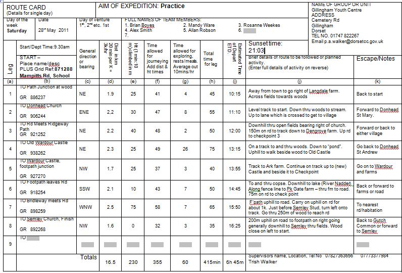
6 A Route Card

7 Aim/Activity Landscape Conservation Land use Nature Local community Group dynamics
 What features are there on your planned route?")
8 Some questions to help you decide what to do? 1) What would all the group find interesting? 2) What sort of countryside are you planning to walk through? 3) What features are there on your planned route? There's no point in doing something about high mountain environments if your route goes through low-level forest and farmland.

9 Activity Plan
10 Information that's needed Its ALL important Days and dates need to be right! Full names Aim - why? Timings of legs are built up by YOU! Checkpoint names as well as Grid Refs! Totals at the bottom sbalance across Including route details & escape routes show you've planned things and help leaders track you
11 How to start Choose the area you are going to walk in. Use an UP TO DATE 1:25,000 Map Decide distance based on your aim usually. (Activity time 6hrs) Can be useful to use a length of string to roughly plan your route first of all, also considering your aim, skill level, and climbs Mark it on your map with a china craft pencil Check it with a Leader Prepare your route card
12 Checkpoints and Campsites Use designated campsites at Bronze or land with the owners permission (toilet/washing facilities?) Assessed Expedition has to be in an unknown area Checkpoints should be a clearly identified point on the ground such as: road/river junction, hill summit, building (vehicle access when you need water?) a checkpoint also provides a valuable check as to how you're doing time wise ahead of time? you will have to wait there until you get back onto the time stated on your route card. if you're late your assessor/supervisor might be stuck there for several hours SO, plan accurately!
13 General Direction or Bearing Bearings are used in wild/open country that you can walk straight across without worrying about footpaths/bridleways Sometimes useful in your route detail, if you have to choose a track from several that seem to go in the same direction If you re using footpaths and bridleways then its more sensible to use a 16 point cardinal compass

14 THE COMPASS DIRECTIONS YOU CAN USE
15 Distances should be to the nearest 0.1km do not try and "fudge" your distances total distances are usually (and easily) checked from the map Inaccurate distances will mean an inaccurate route card so you ll either be hanging around waiting or constantly late and doing too much

16 Calculating walking times Calculate for the slowest walker 4k per hour is not unreasonable if you are fit and have good map skills. i.e. It will take 15minutes to walk 1K, 30mins to do 2K So, 6k =?, 3.5 =? If heavily laden or hesitant, 3 km in 1hr i.e. 4.5K = 90min; 6K = 120mins 2.1K =? ALWAYS write your leg timings in minutes
17 Height Gain and using Naismith s Rule You are expected to take into account any climbs as it will probably take longer! For every 10m climbed allow an extra 1 minute. Count the contour lines crossed going uphill Adding time for going down isn't done for local countryside

18 Time for exploring, rests etc the group should start walking at a realistic time each morning and arrive at their campsite at a reasonable time. Time must be allowed for stops, lunch etc. its usually works out about an average of 10minutes per hour try to use break time to round up total time makes it easier to do ETD
19 Route Details Brief and clear, not long and complicated. Make sure you identify the route you are taking so that people know where to look for you if you don t arrive. Gradient? Woods? Open? Buildings? Fenceline? Track? Could use to find the way without a map
20 REMEMBER - TAKE CARE WITH ROUTE CARDS AND EXPEDITION PREPARATION LIVES MAY DEPEND ON THEM
21 YOUR TASK Work in pairs In Coffee Bar, S Hall, Yellow room Pencil, map, partially completed route card, compass or romer NAME your route card with your two names Complete your route card
Below is an example of a well laid-out template of a route card used by the Sionnach Team which is a good format to begin with.
 Route Card A route card is used as a navigational aid to hill walkers by setting out a step by step plan for an intended hike. It is good practice to make out a route card before every hike you or your
A Circular Walk from Chapel Carn Brea
 A Circular Walk from Chapel Carn Brea 4.3 Miles A Walk Visiting Five Historic Ancient Sites This circular walk offers the possibility of several alternatives, depending on the walker s available time and
DoE Route Setting and Activity
 DoE Route Setting and Activity How long should each day last? Expedition Level Duration Daily Activity Bronze Level 2 Days and 1 Night 6 Hours of planned activity Silver Level 3 days and 2 Nights 7 Hours
ID: 283 Distance: 6.2 miles Height gain: 500 Metres Map: Explore OL 19 Contributor David and Chris Stewart
 Walkingworld Wild Boar Fell ID: 283 Distance: 6.2 miles Height gain: 500 Metres Map: Explore OL 19 Contributor David and Chris Stewart Features Birds, Great Views, Hills or Fells Description: Wild Boar
GRINDLEFORD GALLOP 2018
 GRINDLEFORD GALLOP 2018 Route Information The Grindleford Gallop follows a fixed 21 mile route through the lanes and paths of Derbyshire. All competitors must follow this route. An OS map of the area with
LAB 5-2 ENERGY CONSERVATION
 NAME: PERIOD: LAB 5-2 ENERGY CONSERVATION QUESTION: What is energy and how does it behave? In this investigation, you will: 1. Discover the relationship between speed and height on a roller coaster. 2.
START - UPHILL BEACH. (tidal!) The West Mendip Way is route-marked with these round blue signs
 The West Mendip Way is route-marked with these round blue signs") START - UPHILL BEACH Start Times: 10:30 11:15 12:00 Please allow sufficient time to check in with the marshals Start on the beach at the high water line (tidal!) The West Mendip Way is route-marked with
START - UPHILL BEACH Start Times: 10:30 11:15 12:00 Please allow sufficient time to check in with the marshals Start on the beach at the high water line (tidal!) The West Mendip Way is route-marked with
Pontfadog. Walk A. Walk A
 Walk A A Bird s eye view of the village 2km. (1 1 /2 miles); height gain 45m. (150ft) about 45 minutes. Six minutes walk along the main road towards Glyn Ceiriog reach a signpost to Llwynmawr. Take the
Leaden Boot Challenge ROUTE INSTRUCTIONS
 Leaden Boot Challenge ROUTE INSTRUCTIONS Section 1 Alstonefield to Ilam From the village hall car park turn R then L and pass through the village keeping to the R to enter Church Street. Pass the Church
BISHOPSTONE CIRCULAR WALK
 BISHOPSTONE CIRCULAR WALK 4½ miles (7¼ km) - allow 2 hours (see maps on final pages) Introduction This walk is within the North Wessex Downs Area of Outstanding Natural Beauty and starts from the small,
Leaden Boot Challenge 2016 ROUTE INSTRUCTIONS
 Leaden Boot Challenge 2016 ROUTE INSTRUCTIONS Section 1 Alstonefield to Ilam (CP2) From the village hall car park turn R then L and pass through the village keeping to the R to enter Church Street. Pass
Slad over to Pitchcombe and back
 The walk climbs up from Slad over Wickridge Hill, descends to near Pitchcombe, then climbs back over Wickridge hill and round the back of Slad. Page 1 Start Point: SO 8718 0732 The Woolpack, Slad Length:
The Mountains are for Everyone. Hillwalking Adventure Skill General Guidance Stages 1 to 9
 The Mountains are for Everyone Hillwalking Adventure Skill General Guidance Stages 1 to 9 Hill Walking Adventure Skills Key Elements Part of the Larger ONE programme roll out A 9 Stage Scheme from first
Exercise Forest Fire
 Exercise Forest Fire NARRATIVE 1. You live up at Upper Lomar Farm, a small farm 21 miles from Garrity Bridge in the North Western Highlands of Scotland (a sketch map is attached). It has been a long, hot
Beautiful Walks from the Blue Ball Inn
 Walk No. 5 RIVER VALLEYS AND MOOR Countisbury, Watersmeet, Hillsford Bridge, Cheriton, Shilstone Hill, Rockford and Chiselcombe. 8.5 MILES APPROX. Walking time four and a half hours approx. OS 1;25,000
Darwin s gigantic blunder
 Trail Darwin s gigantic blunder Explore how ice shaped the landscape and why Charles Darwin made a nice mess of Glen Roy Time: 1hr 10 mins Distance: 2 miles Landscape: rural At Glen Roy a curious feature
DUKE OF EDINBURGH S AWARD. Expedition Planning Pack Bronze 2018
 DUKE OF EDINBURGH S AWARD Expedition Planning Pack Bronze 2018 Mendip, Lyncombe Drive, Churchill, North Somerset, BS25 5PQ Call 01934 834 877, search www.mendip.me or email info@mendip.me CONTENTS Useful
COSTA BLANCA MOUNTAIN WALKERS - WALK DESCRIPTION. Visit for more walks descriptions in Spain
 COSTA BLANCA MOUNTAIN WALKERS - WALK DESCRIPTION Visit www.walksinspain.org for more walks descriptions in Spain Walk description originally prepared by:- Ralph Phipps Last Updated 25th Sep 2015 Title
Sponsored by. statestreet.com
 /STATESTREETISLANDWALK #ISLANDWALKJSY Sponsored by statestreet.com Important Information If you forget everything else PLEASE remember the following.» Remember to check OUT of every checkpoint» If you
Survey of Littleton Down
 Survey of Littleton Down 05 November 2014 The Team: John and Jenny Barnard 1) Introduction Littleton Down (Hill Number 2911, Section 42, OS 1:50000 Map 197, OS 1:25000 Map 121, Grid Ref. SU941150) is listed
Bronze Duke of Edinburgh Award
 Bronze Duke of Edinburgh Award What is the Duke of Edinburgh Award? The DofE is the world s leading youth achievement award, giving millions of 14 to 24-year-olds the opportunity to be the very best they
This path goes past an old tree nursery and sawmill. After 800m it crosses over a lane. Follow the bridleway fingerpost into the woods.
 FRENSHAM PONDS 11K CIRCULAR TRAIL 2½ HRS GU10 2DA This magnificent heathland trail starts in woodland and then brings you out onto the open heather of Frensham Common, with no roadwork! The route runs
Figure 1 Understanding Map Contours
 Figure 1 Understanding Map Contours The light brown lines overprinted on topographic maps are called contour lines. They indicate the elevation above sea level of land features and thus permit you to view
Camp Jack Wright PERMANENT ORIENTEERING COURSE (2004)
") Camp Jack Wright PERMANENT ORIENTEERING COURSE (2004) WHAT IS ORIENTEERING? The skill which enables a person to navigate with a map. In the competitive sport, the winner is the person who finishes in the
Camp Jack Wright PERMANENT ORIENTEERING COURSE (2004) WHAT IS ORIENTEERING? The skill which enables a person to navigate with a map. In the competitive sport, the winner is the person who finishes in the
Morning Copse near Maidstone, Kent acres of Ancient Woodland with a pond, bluebells and mature oak. 26,500 (freehold)
") WOODS 4 SALE Phone: 01248 364 362 www.woods4sale.co.uk UK Woodland & Woods For Sale: Specialising in the Sales of Small Woodlands in England, Scotland and Wales for Recreation, Wildlife Conservation and
WOODS 4 SALE Phone: 01248 364 362 www.woods4sale.co.uk UK Woodland & Woods For Sale: Specialising in the Sales of Small Woodlands in England, Scotland and Wales for Recreation, Wildlife Conservation and
Self-Guided Walk Langdale Pikes. Start & Finish: NT car park (free to members) at Sticklebarn - on the right just beyond the New Dungeon Ghyll hotel.
 at Sticklebarn - on the right just beyond the New Dungeon Ghyll hotel.") Self-Guided Walk Langdale Pikes Key Information These mountains form a collection of spires and cliffs on the north side of Langdale. This walk visits four of the main tops Pavey Ark, Harrison Stickle,
Self-Guided Walk Langdale Pikes Key Information These mountains form a collection of spires and cliffs on the north side of Langdale. This walk visits four of the main tops Pavey Ark, Harrison Stickle,
Map & Compass so easy a caveman can do it!
 Map & Compass so easy a caveman can do it! Compass Basics Opening Comments Terms of a compass Boxing a needle Get a bearing (you to a point) Get a bearing (a point to you) Orienting a map Get a bearing
Cragg Vale to Todmorden
 Cragg Vale to Todmorden Map Co-Ordinates : SE 002232 The Te Duem Stone near Stoodley Pike symbolises a long tradition of wayfaring. Crossing the the Pennine Way, the route drops down towards Lumbutts and
Wicklow Mountains Path Survey
 Wicklow Mountains Path Survey Ballinacor Croaghanmoira Fananierin Start to Finish: T 11723 86602 to T 11175 89057 Altitude (lowest highest): 385m 664m Weather: Hot Access: Coolgarrow forest entrance Surveyed
Lund Stones. Lund Stones. Unknown Stones. Climbs - 40 Altitude 300m Faces South, South West Grid ref SE
 Climbs - 40 Altitude 300m Faces South, South West Grid ref SE 175713 Lund Stones Other condition info: An isolated edge with good rock, that, once cleaned, reveals fine and distinctive problems, across
DofE TRAINING PACK 2018
 SCHOOL CAMP Ltd, Unit 1, Old Legions Place, Resolven, Neath. SA11 4NJ. Tel: 01639 710348 Email: info@schoolcamp.co.uk DofE TRAINING PACK 2018 SCHOOL GROUP ID Participants name edofe number 1 2 3 4 5 6
2012 Oregon State Science Olympiad. B-Division Road Scholar Event National Wildlife Refuge Site Selection. Student Participants:
 2012 Oregon State Science Olympiad B-Division Road Scholar Event National Wildlife Refuge Site Selection Student Participants: School/Team: To answer the questions you will need a pencil, ruler, protractor,
SPRING ODYSSEY APPLICATION 2016 An Adventurous Journey
 SPRING ODYSSEY APPLICATION 2016 An Adventurous Journey Outdoor Program Contact Haseena Hamzawala Spring Odyssey Facilitators Haseena Hamzawala & Matt Edens/Bea White INTRODUCTION The Spring Odyssey is
Wicklow Mountains Path Survey
 Wicklow Mountains Path Survey Glenmacnass Tonelagee Start to Finish: O 114 030 to O 085 016 Altitude (lowest highest): 370m 817m Weather: Sunny day, hot Access: Military Road, Glenmacnass Surveyed by:
HARDMOORS 55 RACE ROUTE 2018 HELMSLEY - GUISBOROUGH
 HARDMOORS 55 RACE ROUTE 2018 HELMSLEY - GUISBOROUGH HELMSLEY - CHECKPOINT 1 (WHITE HORSE) 1. Leave RACE START, continue ahead on road (Baxtons Sprunt) At crossroads turn right down Canons Garth eventualy
White Horse. For your own safety warn the MCA Coastguard Helicopter (01305) They have been known to low fly in this area
 They have been known to low fly in this area") Site Code 2.078 OS Grid Ref: SY 715 844 (Map 194) GPS: N50:39.514 Owned and farmed by: Nearest Phone: Casualty Units: W2:24:273 P & J Critchell Farm Osmington 01305 834314 Broadmayne or Sutton Poyntz County
Site Code 2.078 OS Grid Ref: SY 715 844 (Map 194) GPS: N50:39.514 Owned and farmed by: Nearest Phone: Casualty Units: W2:24:273 P & J Critchell Farm Osmington 01305 834314 Broadmayne or Sutton Poyntz County
Scout Skills - Campsite Layout and Selection
 Scout Skills - Campsite Layout and Selection S Item Code FS315071 May/05 Edition no 2 (103759) 0845 300 1818 Camping is very much part of Scouting, an activity undertaken by most Members at one time or
Gors Lydan barrows and medieval huts
 Walk Information: Maps: OS Explorer 214 Distance: 5.5 miles / 9 kilometres Duration: 4.5 to 5 hours Difficulty: Easy. Good paths and no steep gradients Start and finish: SO 11977545 Walk summary The walk
Victoria Falls Lookout to Blue Gum Forest
 Victoria Falls Lookout to Blue Gum Forest 8 hrs Experienced only 13.8 km One way 5 112m This long day-walk follows a remote track down from Victoria Falls lookout, passing the waterfall, and into the Grose
HARDMOORS ROUTE DESCRIPTION
 HARDMOORS 60 2016 ROUTE DESCRIPTION RACE START (GUISBOROUGH) - CHECKPOINT 2 (SALTBURN) DISTANCE 9 MILES CUT OFF TIME 1030 GRID REF OS 666 208 1. Leaving the Sea Cadets Hall, turn left onto the road and
Barton on Sea. Owned by: New Forest District Council Wind Direction SW SE (135 to 225 ) Best: S (180 )
 Best: S (180 )") OS Grid Ref: SZ 242 929 (Map 195) GPS: N50:44.113 W1:39.507 Owned by: New Forest District Council Wind Direction SW SE (135 to 225 ) Best: S (180 ) Nearest Phone: Casualty Units: Junction of Marine drive
OS Grid Ref: SZ 242 929 (Map 195) GPS: N50:44.113 W1:39.507 Owned by: New Forest District Council Wind Direction SW SE (135 to 225 ) Best: S (180 ) Nearest Phone: Casualty Units: Junction of Marine drive
Hindhead, Keffolds Copse and Gibbet Hill
 point your feet on a new path, Keffolds Copse and Gibbet Hill Distance: 6 km=4 miles Region: Surrey Author: Schwebefuss Refreshments: Punch Bowl Café moderate walking Date written: 14-apr-2015 Last update:
Beautiful Walks from the Blue Ball Inn
 Walk No. 2 WINSTONS WALK Countisbury, Wind Hill, Watersmeet, Ash Bridge and Winston s path. 5 Miles approx. Walking time- Two and a half hours approx. (Not including Breaks) OS 1:25,000 Sheet 64/74 Lynton
IOW Ramblers Submission Paper to the Sept 2016 ROW Improvement Plan Consultation.
 IOW Ramblers Submission Paper to the Sept 2016 ROW Improvement Plan Consultation. The current Island Rights of Way Improvement Plan is a comprehensive document and much of its content is still relevant
Putting up a Deluxe Bell Tent
 Hello, and thanks for buying one of our Bell Tents. Here is the best way to put up your Bell Tent. One person is shown doing this but the more people there are, the faster it goes up (our current record
INTERPRETING TOPOGRAPHIC MAPS (MODIFIED FOR ADEED)
") INTERPRETING TOPOGRAPHIC MAPS (MODIFIED FOR ADEED) Science Concept: Topographic maps give information about the forces that shape the features of Earth. Objectives: The student will: identify land features
INTERPRETING TOPOGRAPHIC MAPS (MODIFIED FOR ADEED) Science Concept: Topographic maps give information about the forces that shape the features of Earth. Objectives: The student will: identify land features
Lordenshaw. What are cup & ring marks?
 Lordenshaw Lordenshaw hill has one of the largest clusters of ancient cup and ring marked stones in the UK. We ve chosen four interesting spots we d like to share with you. What are cup & ring marks? The
Baggy Point, Croyde, North Devon
 Baggy Point, Croyde, North Devon A walk using the South West Coast Path that is likely to be suitable for people with impaired mobility or with a pushchair, wheelchair, or mobility scooter. The Coast Path
HIKING/BIKING IN MERRITT AREA
 HIKING/BIKING IN MERRITT AREA Coquihalla Lakes: Just inside the southern boundary of BC Park's Coquihalla Summit Park, a nice little twin lakes paddle with a private campground & lodge is the Coquihalla
The Mendip Way. Route Directions and Maps Uphill to Wells
 The Mendip Way Route Directions and Maps Uphill to Wells Website: www.mendiphillsaonb.org.uk Email: mendip@mendiphillsaonb.org.uk Facebook & Twitter: @MendipHillsAONB Phone: 01761462338 1 Uphill to Loxton
Kirigalpoththa Nature Trail Horton Plains National Park
 Kirigalpoththa Nature Trail Horton Plains National Park Trail Difficulty: Easy Moderate Strenuous Tough Trail Head: Horton Plains Visitor Centre Nearest Town: Pattipola Nearest City: Nanu-Oya Access to
THE CARAVAN AND MOTORHOME CLUB NORTH LANCASHIRE CENTRE GUIDANCE FOR RUNNING RALLIES FOR RALLY OFFICERS (REVISED EDITION FEBRUARY 2018)
") THE CARAVAN AND MOTORHOME CLUB NORTH LANCASHIRE CENTRE GUIDANCE FOR RUNNING RALLIES FOR RALLY OFFICERS (REVISED EDITION FEBRUARY 2018) RALLY OFFICERS The Rally Officer must be Centre Member. However, it
THE CARAVAN AND MOTORHOME CLUB NORTH LANCASHIRE CENTRE GUIDANCE FOR RUNNING RALLIES FOR RALLY OFFICERS (REVISED EDITION FEBRUARY 2018) RALLY OFFICERS The Rally Officer must be Centre Member. However, it
8.50am for morning exams to start at 9am 1:20pm for afternoon exams to start at 1.30pm
 GCSE Exam Briefing Be on time for your exams. Most of your GCSE s will be in the Sports hall. 8.50am for morning exams to start at 9am 1:20pm for afternoon exams to start at 1.30pm Check your timetable
Answers to Your Turn. Chapter 2. Maps and mapping
 Geog. 1 Answers to Your Turn Chapter 2. Maps and mapping Chapter 2.1 Mapping connections 1. A = Isle of Man; B = Northumberland; C = Cornwall; D = Surrey; E = Shrewsbury; F = Nigeria; G = Japan; H = China;
Ranmore Common and Polesden Lacey
 point your feet on a new path Ranmore Common and Polesden Lacey Distance: 9½ km=6 miles Region: Surrey Author: Fusszweig Refreshments: Polesden Lacey easy walking Date written: 20-dec-2016 Last update:
5 MAP SPECIFICATION FOR SKI-ORIENTEERING
 5 MAP SPECIFICATION FOR SKI-ORIENTEERING 5.1 General Maps for ski orienteering are based on the specifications for foot-orienteering maps. However in order to meet the specific requirements put on the
Tool: Overbooking Ratio Step by Step
 Tool: Overbooking Ratio Step by Step Use this guide to find the overbooking ratio for your hotel and to create an overbooking policy. 1. Calculate the overbooking ratio Collect the following data: ADR
Kimmeridge. Owned by: Smedmore Estates Wind Direction SSW W (210 to 270 ) Best: SW (240 )
 Best: SW (240 )") Site Code 2.073 OS Grid Ref: SY 926 795 (Map 194) GPS: N50:36.909 W2:06.357 Owned by: Smedmore Estates Wind Direction SSW W (210 to 270 ) Best: SW (240 ) Top farmed by: Mr J.Hole Farm 01929 480936 Bottom
Site Code 2.073 OS Grid Ref: SY 926 795 (Map 194) GPS: N50:36.909 W2:06.357 Owned by: Smedmore Estates Wind Direction SSW W (210 to 270 ) Best: SW (240 ) Top farmed by: Mr J.Hole Farm 01929 480936 Bottom
Suggested Day Hikes. Mount Greylock State Reservation 3, 4 1, 2. Take a Hike! Things to remember:
 Suggested Day Hikes Mount Greylock State Reservation Take a Hike! This guide offers suggested day hike routes in two parts: 1) Year-round Hikes and 2) Seasonal Hikes (late-may to Nov.1). Use this guide
2016 Winter Camp Merit Badge Addendum
 2016 Winter Camp Merit Badge Addendum Clements Scout Ranch Trevor Rees-Jones Scout Camp 2016 Winter Camp Merit Badge Addendum The Merit Badge program is an important feature of our Winter Camp program.
The Atlas of Hillforts of Britain and Ireland. Hillfort survey notes for guidance
 The Atlas of Hillforts of Britain and Ireland Hillfort survey notes for guidance The collection of surveys for the Atlas is now finished but you can use this form and the accompanying Notes for Guidance
Ardingly Lake, Ouse Valley, Borde Hill
 point your feet on a new path Ardingly Lake, Ouse Valley, Borde Hill Distance: 14 km=9 miles or 12½ km=8 miles Region: West Sussex Author: Hautboy Refreshments: Borde Hill Map: Explorer 135 (Ashdown Forest)
Ystwyth and Rheidol Bridleway Routes. Route 2:Llanilar Circular
 Ystwyth and Rheidol Bridleway Routes Route 2:Llanilar Circular Route overview and terrain: A long circle using connecting ridges with fine views to link the Rheidol and Ystwyth river valleys. The route
Transcript. Practice Approaches. Featuring: John Krug
 Practice Approaches Featuring: John Krug Copyright PilotWorkshops.com, LLC. This material is available to members of the PilotWorkshops.com web site, which is the only place it can be legally obtained.
Hay Wood, Rowington and Baddesley Clinton - Warwickshire
 Hay Wood, Rowington and Baddesley Clinton - Warwickshire Starts at Lay-by alongside Hay Wood 2 hours 30 minutes 5.5miles 8.8km Leisurely ID: 0.683 Developed by: John Clift Checked by: Andy Page www.ramblersroutes.org
You must have: Ruler graduated in centimetres and millimetres, protractor, pen, HB pencil, eraser, calculator.
 Write your name here Surname Other names Edexcel Functional Skills Centre Number Mathematics Level 1 Candidate Number Wednesday 12 May 2010 Time: 1 hour 15 minutes Paper Reference FM101/01 You must have:
BATTLE OF BRADFIELD ROAD BOOK 2018
 BATTLE OF BRADFIELD ROAD BOOK 2018 Welcome to the Event Guide for the 2018 Battle of Bradfield on Sunday 18/3/18 which starts and finishes in Stannington, Sheffield - this guide will tell you all you need
Skiing and Snowshoes on Un-groomed Fernan Saddle Terrain
 Skiing and Snowshoes on Un-groomed Fernan Saddle Terrain Three ski or snowshoe routes are available from the Fernan Saddle Parking Lot which either do not cover routes ordinarily groomed for snow machine
Map: Landranger #27 Forres and Nairn and 36 Grantown and Aviemore
 THE DAVA WAY This is a newly created long distance route that runs from Forres to Grantown, mostly following the old railway line. You will need to detour around a couple of sections that are not really
General Considerations For Cross Country Orienteering Courses: Design and Set Guidelines
 General Considerations For Cross Country Orienteering Courses: Design and Set Guidelines Objective Orienteering's slogan is that it is "the thinking sport." Doing well requires a combination of physical
5.2 Angular Motion. Motion and Force. Objective. Materials. Introduction /// TEACHER ALERT /// Directed Instruction. Content
 5.2 Angular Motion Motion and Force Objective Students will define angular motion and distinguish between rotational and periodic motion. Materials Blackline Master 5.2A Discover: Amusement Parks Blackline
Hillwalking. Hillwalking Adventure Skill
 Hillwalking Hillwalking Adventure Skill External qualification BOS - the Irish Mountain Training Board in the South and MLTNI in Northern Ireland run a number of Mountain Leadership courses. Those who
Orienteering. The fundamental outdoors skill!
 The fundamental outdoors skill! Orienteering Nothing will make you feel more confident in the out of doors like knowing how to find your way in the woods. Orienteering Prepared by: Jeffrey Lybarger Assistant
For more information and to buy this book click here ISBN: CICERONE. Guides for walkers, trekkers, mountaineers, climbers and cyclists
 For more information and to buy this book click here ISBN: 9781852844103 CICERONE Guides for walkers, trekkers, mountaineers, climbers and cyclists www.cicerone.co.uk SALÈVE AND VALLÉE VERTE SALÈVE WALK
Math at the Amusement Park
 Your Assignment: Math at the Amusement Park Your math teacher has decided to sponsor a class field trip to an amusement park. Your task is to research information about the prices and other amenities that
Hampshire Scouts. Expedition Challenge Weekend
 Expedition Challenge Weekend The aim of this weekend is to enable Scouts to complete their Expedition Challenge. Scouts can either undertake a hike expedition or a cycle expedition. Scouts will arrive
CWMGIEDD FROM ABERCRAVE
 Abercrave to Cwmgiedd Walk Page 1 Starting from The Abercrave Inn. Grid Ref: SN 824128 From the Abercrave Inn, an 11.3km (7 miles) walk to the foothills of the Cribarth Mountain, then through forest to
Manche2Med a leisurely ride across France June 2017
 Manche2Med a leisurely ride across France June 2017 The book had sat on my bookcase for several years France en Velo, setting out a detailed route from St Malo to Nice. I d pick it up every now and then,
A Tour of the Valle del Gizio
 Walk 25 A Tour of the Valle del Gizio Walking time 5hrs 30mins (4hrs if Colle Mitra is omitted) Difficulty 2 (likely to be snowbound in winter months); 1 (if Colle Mitra is omitted) Ascent/descent 570m/570m
Outdoor Education Worksheets
 Outdoor Education Worksheets OUTDOORS You will need: First Aid Kit Appropriate clothing for whole group (sunny/wet weather) Charged mobile phones and appropriate numbers of adult helpers in case of group
Rescue in Snowdonia Snowdon
 Rescue in Snowdonia Snowdon Background Snowdonia ational Park contains the tallest mountain in Wales Snowdon. The mountain measures 1085m and there are six public rights of way to the summit. There are
Charnley Explorer June 24 - July 15, 2018 Bachsten Creek and the Charnley River. Second draft: 14 November 2017
 Charnley Explorer June 24 - July 15, 2018 Bachsten Creek and the Charnley River. Second draft: 14 November 2017 The best part of the original section one is now part of out Gibb Road Gorges trip. The dates
Duke of Edinburgh Award Scheme. Bronze level Information evening for parents Wednesday 12 th March 2014
 Duke of Edinburgh Award Scheme Bronze level Information evening for parents Wednesday 12 th March 2014 When did we start? HHS started to run the award scheme in the early eighties. Mr Stanbridge, Mr Chappelow,
Etna winter expedition 1
 Etna winter expedition Etna, still active volcano. I ve been always tempted to climb it. I found a cheap flight ticket to Catania in February and I told myself why not in the winter! Two adventurous friends
The 34 th Poppyline Marathon
 The 34 th Poppyline Marathon Saturday 9th June 2018 - Route Description Emergency number: 07906 404673 or 07597 052572 Ahd - Ahead BL - bear left BR - bear right BW - bridleway Cont - continue FB - footbridge
A topographic map shows:,,,,
 Name: Period: Mapping the Earth Notes What is a map? Label the compass directions: What does latitude measure? What is the name of the 0 latitude line? Where is 90 north latitude? Where is 90 south latitude?
Advance Planning (over 1 year in advance) What kind of elective do you want? As they say, it's all about location, location, location.
 What kind of elective do you want? As they say, it's all about location, location, location.") Advance Planning (over 1 year in advance)... 1. What kind of elective do you want? As they say, it's all about location, location, location. Let's start at the beginning. The first thing you need to decide
Advance Planning (over 1 year in advance)... 1. What kind of elective do you want? As they say, it's all about location, location, location. Let's start at the beginning. The first thing you need to decide
Congewai Track Head (East) to Watagan Headquarters
 to Watagan Headquarters") Congewai Track Head (East) to Watagan Headquarters 7 hrs Hard track 17.2 km One way 4 973m This full day walk starts from the Congewai valley trackhead (east) and follows the Great North Walk up into the
Congewai Track Head (East) to Watagan Headquarters 7 hrs Hard track 17.2 km One way 4 973m This full day walk starts from the Congewai valley trackhead (east) and follows the Great North Walk up into the
Coaster Creators. Science/Math Module. Grades 6-8
 Science/Math Module Grades 6-8 By Virginia Barrett MAP Team Member Lathrop R-II School District Northwest Regional MAP Center 1 Purpose: This module can be used as the culminating activity for a unit of
Title ID Number Sequence and Duration. Age Level Essential Question Learning Objectives
 Title ID Number Sequence and Duration Age Level Essential Question Learning Objectives Lesson Activity Design a Roller Coaster (2 sessions, 60-80 minutes) HS-S-C3 Session 1: Background and Planning Lead
Erskine Creek via Pisgah Rock and Jack Evans
 Erskine Creek via Pisgah Rock and Jack Evans 4 hrs 30 mins 7.1 km Circuit Very experienced only 6 421m This walk visits some great lookouts and explores the lower section of Erskine Creek. Most of the
Duke of Edinburgh Award Scheme. Bronze level Information evening for parents Wednesday 11 th March 2015
 Duke of Edinburgh Award Scheme Bronze level Information evening for parents Wednesday 11 th March 2015 When did we start? HHS started to run the award scheme in the early eighties. Mr Stanbridge, Mr Chappelow,
Berowra Waters to Cowan Station
 Berowra Waters to Cowan Station 3 hrs 30 mins 7.2 km One way Hard track 597m This is a hilly walk out of the beautiful Berowra Waters valley to Cowan Station. There are many wide views across Berowra Creek
As pretty as a picture
 43 As pretty as a picture Discover this enchanting stroll through classic Kentish countryside and peaceful Plaxtol. Shipbourne Village Green 44 44 Shipbourne Crown copyright 0009238. St Giles Church Location:
Survey of An Dun. 24th March The Team: John Barnard and Graham Jackson.
 Survey of An Dun 24th March 2012 The Team: John Barnard and Graham Jackson. 1) Introduction An Dun (Section 5B, OS 1:50000 Map 42, Grid Ref. NN717805) is a Corbett and a Marilyn. This mountain has two
Road Scholar Gopher Science Olympiad Invitational January 6, Team #: Team Name: Names: Score:
 Road Scholar Gopher Science Olympiad Invitational January 6, 2018 Team #: Team Name: Names: Score: Welcome to Road Scholar! Your Science Olympiad team is planning a trip to an invitational tournament in
COSTA BLANCA MOUNTAIN WALKERS - WALK DESCRIPTION. Visit for more walks descriptions in Spain
 Visit www.walksinspain.org for more walks descriptions in Spain Walk description originally prepared by:- Ralph Phipps Last Updated 15 th July 2016 Title of Walk Location of Start (include name of nearest
COURSE & TRAINING ADDENDUM
 COURSE & TRAINING ADDENDUM WINTER CAMP 2017 - MERIT BADGE ADDENDUM TABLE OF CONTENTS INTRODUCTION... 1 HELPFUL HINTS... 1 CAMPMASTER COURSE REGISTRATION... 1 COURSE SCHEDULES... 2 COURSE MATERIALS... 2
Introduction to Topographic Maps
 Introduction to Topographic Maps DIRECTIONS: Read all of the following content. READ EVERYTHING!! At the end of the packet, you will find two topographic maps. Your task is to indentify each of the elevations
Delamere Loop. The. Useful Businesses Equestrian Escapes Tailor-made horse riding holidays in Cheshire. Tel:
 The Loop Accommodation Providers Akesmere Bed & Breakfast OS Grid Ref. SJ589/669 B&B for horse and rider. Chester Road, Little, Tarporley, Cheshire CW6 9ER Tel: 01829 760348 www.akesmerefarm.co.uk Useful