Coralville Limestone
|
|
|
- Francis Gibbs
- 5 years ago
- Views:
Transcription
1 Coralville Limestone Coralville Parks and Recreation Created in 2016 pg. 1
2 Comprehensive Overview and Pricing Sheet Roundabouts Heartland drive pg. 2 Commerce Road and Commercial Park Holiday Road and Corridor Way Highway 6 Mall Entrance Drive and north of Hwy th and north Hwy 6 12 th Ave and north Hwy 6 10 th Ave and Hwy 6 1 st Ave and Hwy 6 Coral Ridge Avenue Intersection of Coral Ridge Ave and Heartland Drive/Holiday Road Coral Ridge Ave and Commerce Drive Intersection West of 1-80 on west side of Coral Ridge Ave to 2 nd street East and west of Coral Ridge Ave Main Mall Entrance East of Coral Ridge Ave Second South Mall Entrance East of Coral Ridge Ave at the Corner of 2 nd Old Towne North and south of 5 th Street and 1 st Avenue North and south of 5 th and 2 nd Street and near the Old School House/Old Town Hall CCPA and Town Center th Street and west 10 th Avenue South of 6 th Street and 10 th Ave and 6th Street and 12 th Ave 5 th Street and 12 th Street South-east corner 5 th Street and 12 th North-west corner North side of plaza on 5 th - CCPA 1 st Ave st Ave Wall in front of Lebeda and Brueggers Bagels Iowa River Gazebo Oakdale Boulevard Planter beds between 1 st Ave and Muddy Creek Bridge Brown Deer Brown Deer Entry Sign on west 1 st Ave and Country Club Drive Brown Deer Entry Sign on east 1 st Ave and Country Club Drive 1 st Ave/North Liberty Road NE and Holiday Road Roundabout Iowa River Landing th and 1 st Ave 9 th Street -University of Iowa Health Care South Entry to Marriot Coralville Conference Center sign Wetland Park East lower plaza east of Marriot, walls and brick paved area East 9 th and Quarry Road Roundabout
3 Map Key: Curved Decorative Wall Straight Decorative Wall Roundabouts Coralville Monument Fountain Monument Vertical Stones Clock Tower Roundabout Iowa River Gazebo Decorative Stone Cube Seats Stone Planters *Map may not depict current planting, most recent aerial 2014 pg. 3
4 Roundabouts Heartland Drive Commerce Road and Commercial Park Holiday Road and Corridor Way pg. 4


5 pg. 5 Heartland Drive East of Rockwell Collins Roundabout Map and Image


6 pg. 6 Commerce Road and Commercial Park Roundabout Map and Image


7 pg. 7 Holiday Road and Corridor Way Roundabout Map and Image
8 Highway 6 Mall Entrance Drive and north of Hwy 6 25 th and north Hwy 6 12 th Ave and north Hwy 6 10 th Ave and Hwy 6 1 st Ave and Hwy 6 pg. 8

9 pg. 9 Highway 6 to 1 st Avenue 3 Maps Below
10 pg. 10

11 pg. 11 Mall Entrance Drive and North Hwy 6 2 curved decorative stone walls; picture depicts both walls on east and west

12 pg th Ave and North of Hwy 6 2 curved decorative stone walls; picture depicts both walls on east and west

13 pg th Avenue and Hwy 6 North side of Hwy 6 Monument signs and small sign on both sides of the street

14 pg th Street and Hwy 6 1 monument sign west side of 10 th Street

15 pg st Avenue and Hwy 6 All four corners has a group of vertical stones
16 Coral Ridge Avenue Intersection of Coral Ridge Ave and Heartland Drive/Holiday Road Coral Ridge Ave and Commerce Drive Intersection West of 1-80 on west side of Coral Ridge Ave to 2 nd street East and west of Coral Ridge Ave Main Mall Entrance East of Coral Ridge Ave Second South Mall Entrance East of Coral Ridge Ave at the Corner of 2 nd pg. 16


17 pg. 17 Coral Ridge Avenue Maps

18 pg. 18 Intersection of Coral Ridge Ave and Heartland Drive/Holiday Road Picture depicts all four corners of intersection

19 pg. 19 Coral Ridge Ave and Commerce Drive Intersection Picture depicts all four corners


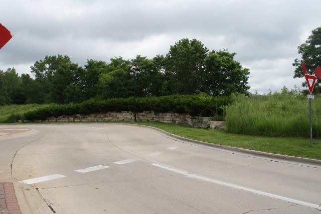
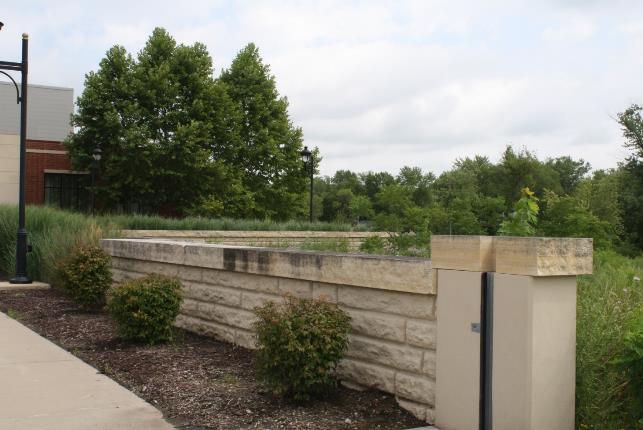
20 West of 1-80 on Coral Ridge Ave to 2 nd street East and west side of Coral Ridge Ave Pictures depict 6 straight stone walls pg. 20
21 pg. 21


22 pg. 22 Coral Ridge Avenue at the main mall entrance Small strip of curved rock on all four sides of the entrance intersection also includes the curved decorative walls and entryways, NOT the Coral Ridge Mall entrance signs and beyond

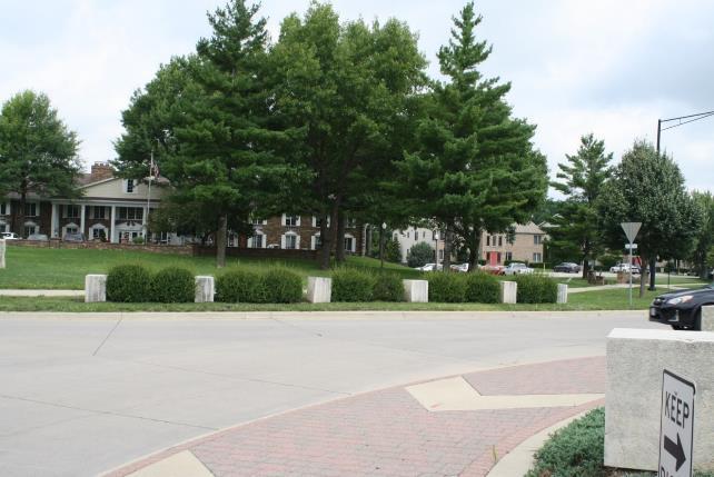
23 pg. 23 East of Coral Ridge Ave Second South Mall Entrance Curved entry walls on the north and south

24 pg. 24 East side of Coral Ridge Ave at the Corner of 2 nd Fountain monument
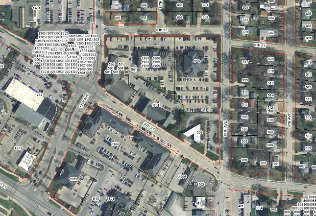
25 Old Towne North and south of 5 th Street and 1 st Avenue North and south of 5 th and 2 nd Street and near the Old School House/Old Town Hall CCPA and Town Center 5 th Street and west 10 th Avenue South of 6 th Street and 10 th Ave and 6th Street and 12 th Ave 5 th Street and 12 th Street South-east corner 5 th Street and 12 th North-west corner North side of plaza on 5 th - CCPA pg. 25

26 pg th Street/CCPA and Town Center Maps
27 pg. 27


28 pg th Street and 1 st Ave Coralville monument and vertical seat wall capstones north and south of 5 th Street

29 pg th and 2 nd Avenue and 5 th Street by 1879 school house and old town hall 4 Old Town/Coralville monument signs on north and south side of the street

30 pg th Street and 10 th Ave West side of the street, low curved seat walls


31 pg th Street and 10 th Ave and 6 th Street and 12 th Ave Low seat wall


32 5 th and 12 th street Low seat wall on 5 th in front of 1150 City Center square, seat wall on monument in south-east corner pg. 32

33 pg th and 12 th North-west corner along the CCPA, seat wall/planter beds

34 pg. 34 Plaza on 5 th CCPA North side curved seat wall
35 1 st Ave 1 st Ave Wall in front of Lebeda and Brueggers Bagels Iowa River Gazebo pg. 35

36 pg st Ave Maps

37 pg st Ave Straight stone wall in front of Lebeda and Brueggers Bagels

38 pg. 38 Iowa River Gazebo Cap stones and pavement, colored concrete plaza
39 Oakdale Boulevard Planter beds between 1 st Ave and Muddy Creek Bridge pg. 39

40 pg. 40 Oakdale Boulevard Map

41 pg. 41 Oakdale Boulevard Planter beds between 1 st Ave and Muddy Creek Bridge
42 Brown Deer Brown Deer Entry Sign on west 1 st Ave and Country Club Drive Brown Deer Entry Sign on east 1 st Ave and Country Club Drive 1 st Ave/North Liberty Road NE and Holiday Road Roundabout pg. 42

43 pg. 43 Brown Deer Map


44 Brown Deer Entry Sign on west 1 st Ave and Country Club Drive Sign and curved decorative walls on north side of country club drive and curved walls on south side of the road pg. 44

45 pg. 45 Brown Deer Entry Sign on 1 st Ave and Country Club Road On East side of 1 st Ave, decorative sign and stone walls


46 pg st Ave/North Liberty Road NE and Holiday Road Roundabout, decorative stones and curve stone wall Map and Images
47 pg. 47
48 Iowa River Landing 9 th and 1 st Ave 9 th Street -University of Iowa Health Care South Entry to Marriot Coralville Conference Center sign Wetland Park East lower plaza east of Marriot, walls and brick paved area East 9 th and Quarry Road Roundabout pg. 48

49 pg. 49 Iowa River Landing Maps


50 9 th and 1 st Ave All cap stone and entry ways signs for two Iowa River Landing signs on the east side of 1 st Ave and the two Coralville Signs on the west side of 1 st Ave pg. 50


51 pg th Street University of Iowa Health Care

52 pg. 52 South Entry to Marriot Coralville Conference Center sign


53 pg. 53 Wetland Park Signage and stone walls behind the Marriott
54 pg. 54


55 pg. 55 East lower plaza east of Marriot Walls and brick paved area

56 pg. 56 East 9 th and Quarry Road Clock Tower Plaza
Customer Service:
 Customer Service: 1-877-905-0500 MIAMI - DADE COUNTY Medical Doctors House Calls 1-855-668-8798 8:00am - 5:00pm 1770 NE Miami Gardens Dr. Unit #1 North Miami Beach, FL 33179 (305) 949-4141 12555-C Biscayne
Getting to The Family Centre
 Getting to The Family Centre 65 Hanson Avenue, Kitchener, Ontario, N2C 2H6 Click the links below to jump to the transportation option you want to use! We ll see you soon! Cycling Directions by Bus From
United States Department of the Interior National Park Service. Boundary Expansion Listed in National Register January 11, 2017
 NPS Form 10900-a (Rev. 8/2002) OMB No. 10240018 United States Department of the Interior National Park Service Boundary Expansion Listed in National Register January 11, 2017 National Register of Historic
Colliers International - Exclusives
 Colliers International - Exclusives INDUSTRIAL - For 3033 Coffey Ln Industrial Under Renovation Bldg SF: 79,30 0050363 APN: 05-50-0 877 Giffen Ave Santa Rosa, CA 9540 Manufacturing Bldg SF: 66,900 0050487
CGV - CSC Arrivals Mall Coomera Sports Centre
 ATHLETES AND TEAM OFFICIALS BUS ROUTE - 480 (DSSA/Coomera) - PRIMARY TO VENUE To Venue CGV - CSC Arrivals Mall Coomera Sports Centre Commence - Arrivals Mall Parklands Dr Left at traffic lights Smith Street
RIDGEFIELD PARKS February 2016
 RIDGEFIELD PARKS February 2016 Hayden Park Neighborhood Park Amenities Sign with Name of Park and City of Ridgefield Logo Lamp Post Parking Area Play Set Swings Sign with Playground Rules Durable Benches
Palm Beach County Traffic Report July 13 through July 20, 2012
 For Immediate Release July 13, 2012 Meredith Cruz, (561) 641-6440 mcruz@corradino.com Palm Beach County Traffic Report July 13 through July 20, 2012 Palm Beach County Palm Beach County traffic will be
5520 STEPHANIE STREET, LAS VEGAS >> ±36,019 SF OFFICE/WAREHOUSE/DISTRIBUTION, LAS VEGAS, NV 89122
 FOR SALE - FREE STANDING INDUSTRIAL BUILDING WITH LARGE FENCED YARD 5520 STEPHANIE STREET, >> ±36,019 SF /WAREHOUSE/DISTRIBUTION,, NV 89122 N DECATUR BLVD S DECATUR BLVD VALLEY VIEW ROAD SE N EASTERN AVE
DIRECTIONS TO HMG OFFICES
 DIRECTIONS TO HMG OFFICES AVON, ROUTE 10 100 Simsbury Road, Avon, CT 06111 (860)-284-5111 FROM I-84 WEST BOUND Take exit 43 (Park Road/West Hartford Center). Turn left at light at end of ramp. At second
CAE003 N ', W ' Columbia St. US 80 (and Market St.) once continued straight west from here. Continue east on Market St.
 once continued straight west from here. Continue east on Market St.") West to east. San Diego to Viejas Casino. CAE001 N 32 42.68', W 117 10.26' Harbor Dr and Pacific Hwy. Terminus of US 80 from 1943 to 1953. Pacific Hwy was US 101. CAE002 N 32 42.67', W 117 10.10' Harbor
West to east. San Diego to Viejas Casino. CAE001 N 32 42.68', W 117 10.26' Harbor Dr and Pacific Hwy. Terminus of US 80 from 1943 to 1953. Pacific Hwy was US 101. CAE002 N 32 42.67', W 117 10.10' Harbor
City of Grand Island Tuesday, December 12, 2017 Council Session
 City of Grand Island Tuesday, December 12, 2017 Council Session Item E-3 Public Hearing on One & Six Year Street Improvement Plan Council action will take place under Resolution item I-1. Staff Contact:
Greenwich Commons. Demographics. For Info Call (908) or visit 1 Mile 3 Miles 5 Miles. Average Income 40,399 $
 or visit 1 Mile 3 Miles 5 Miles. Average Income 40,399 $") highly desirable & visible location provides unparalleled exposure for any medical or professional office. With its 42,258 (+/-) sq. ft. layout & beautiful two-story brick facade, is the perfect location
highly desirable & visible location provides unparalleled exposure for any medical or professional office. With its 42,258 (+/-) sq. ft. layout & beautiful two-story brick facade, is the perfect location
JEM Family Campmeeting 2018 Information Sheet
 Campmeeting Theme/Vision A powerful week of meetings that will minister to the whole family! Campmeeting Age Dates All ages are welcome to attend this family camp In order to attend the breakout rallies,
WEST LAND USE MASTER PLAN AND DESIGN GUIDELINES PHASE 1 SUMMARY
 WEST LAND USE MASTER PLAN AND DESIGN GUIDELINES PHASE 1 SUMMARY WELCOME / AGENDA WELCOME PROJECT OVERVIEW PUBLIC MEETING RESULTS/STAKEHOLDER INPUT MARKET STUDY RESULTS WHERE WE RE HEADED NEXT STEPS STEERING
1.2 Corridor History and Current Characteristics
 SECTION 1 Description and Background of Study Area 1.1 Introduction This preliminary engineering report was prepared for the Alaska Department of Transportation and Public Facilities (ADOT&PF). It is part
FY TIP Fiscal Constraint 2017 Total Commitments. agencies (the Michigan Department of programmed in the Kalamazoo Area
 KALAMAZOO AREA TRANSPORTATION STUDY FY 2017-2020 TRANSPORTATION IMPROVEMENT PROGRAM MARCH 2019 AMENDMENTS The program is developed using the continuing, What is the TIP? cooperative, and comprehensive
Driving and Parking Directions to the UTSA Main Campus and Maps. Thursday, August 2, 2012: Driving and Parking Directions to Tobin Ave.
 Driving and Parking Directions to the UTSA Main Campus and Maps Free parking is provided for participants of the Fourth Annual Texas Higher Education Symposium. For each symposium day, there is a designated
Exposition Light Rail Transit Project
 Exposition Light Rail Transit Project Project Status Update Meeting Culver City Senior Center Wednesday, July 16, 2008 Description 8.6 mile corridor from downtown to Culver City in West Los Angeles 1.3
OFFERING MEMORANDUM. Applebee s - Ground Lease Walmart Supercenter Outparcel Warren, MI
 Applebee s - Ground Lease Walmart Supercenter Outparcel Warren, MI Florida Investment Sales Exclusively Retail. Extensive Solutions. JOHN ARTOPE Executive Vice President, Market Leader D 407.902.2621 john.artope@srsre.com
April 4, 2014 Chuck McGinness, FDOT TREASURE COAST TRAFFIC REPORT April 4 through April 11, 2014
 April 4, 2014 Chuck McGinness, 954-777-4090 Chuck.McGinness@dot.state.fl.us FDOT TREASURE COAST TRAFFIC REPORT April 4 through April 11, 2014 TREASURE COAST Construction and maintenance-related lane closures
FDOT Treasure Coast Traffic Impact Report March 25 through April 1, 2016
 March 25, 2016 Chuck McGinness, 954-777-4302 chuck.mcginness@dot.state.fl.us FDOT Treasure Coast Traffic Impact Report March 25 through April 1, 2016 TREASURE COAST Construction and maintenance-related
Fuller/Fuller Heights Road Improvements
 Fuller/Fuller Heights Road Improvements Total Project Cost - $4.4M Project Description This project will construct a mini-roundabout at the intersection of Fuller Heights Road and Old Triangle Road to
City of North Liberty
 City of North Liberty City Council Agenda Special Session August 3, 11 AGENDA North Liberty City Council August 3, 11 Special Session :3 p.m. Council Chambers 1. Call to order.. Roll call. 3. Approval
Fiesta Commons Shopping Center
 Fiesta Commons Shopping Center NEC OF SOUTHERN AVE & ALMA SCHOOL RD, MESA, AZ PROPERTY SIZE: 163,420 Sq. Ft. Great Infill Property across the street from Fiesta Regional Mall, Bank of America Tower, Carrington
Directions to US Drives
 Directions to US Drives From Interstate Highway 90 (East or West of Buffalo) (Via Interstate 290 & Interstate 190) Follow the highway signs to Niagara Falls, one of the Seven Natural Wonders of the World.
RIVERFRONT REVITALIZATION PLAN
 PROJECT SITE River s Edge North 75 ac Lewis & Clark Landing 36 ac Gene 9.6 ac River s Edge South 36 ac Heartland of America Park 42 ac CENTURY LINK GALLUP CONAGRA TOM HANAFAN RIVER S EDGE THE BREAKERS
JUNCTION AVENUE
 2585-2595 JUNCTION AVENUE SAN JOSE, CA Flexible Class A Office Availability: ±27,647 SF Single Floor, ±55,295 SF Full Building or ±110,590 SF Full Campus 01Aerial 02Highlights 03Map 04Building Specifications
THREE MILE PLAN TOWN OF SUPERIOR COLORADO
 THREE MILE PLAN TOWN OF SUPERIOR COLORADO February 23, 2015 INTRODUCTION This document has been prepared by the Town of Superior, Colorado, to address the existing and proposed land uses within an approximate
Regional Wayfinding Sign Strategy Thurston County Trails 2017
 Regional Wayfinding Sign Strategy Thurston County Trails 2017 Partners: Members and partnering organizations of the Thurston Thrives Community Design Action Team City of Lacey, City of Olympia, City of
Below is the section of the Byway discussed in the Tazewell County meeting. Primary coal sites are noted on the map.
 APPENDIX H: PUBLIC PARTICIPATION SERIES OF TOWN MEETINGS Virginia Coal Heritage Trail Corridor Management Plan Meeting in Richlands on the Tazewell County portion of the Pocahontas Trail September 21 st
Citrus Heights Creek Corridor Trail Project Trail Advisory Group Field Trip #2 September 11, :00 11:00 am Trellis Hall, Citrus Heights
 September 11, 2013 9:00 11:00 am Trellis Hall, Citrus Heights Project Overview The City of Citrus Heights is studying the feasibility of establishing a multi use trail system within the City s 26 miles
STREET CONSTRUCTION PROGRAM SUMMARY CALENDAR YEAR 2018 / 2019 FISCAL YEAR Street From To Construction Type Cost Estimate
 CALENDAR YEAR 2018 / 2019 FISCAL YEAR 2019 Grandview & University Roundabout Grandview & University Intersection Street / Intersection Reconstruction 900,000 TSF, ICAAP, STP 850,000 East-West Corridor
BRIEF OVERVIEW ORLANDO NORTH AIRPARK ENTERPRISE ZONE
 BRIEF OVERVIEW ORLANDO NORTH AIRPARK ENTERPRISE ZONE The Orlando North Airpark Enterprise Zone is a rare opportunity for any company desiring to relocate or open a new operation in the State of Florida.
PARAGON Outlets NEW YORK CITY
 CENTER OVERVIEW Less than 8 miles north of Manhattan, Paragon Outlets New York City will be a flagship center situated at the intersection of several major highways in the Bronx. This state of the art
MIAMI RIVER COMMISSION
 COMMISSION July 13, 2015 CG LLC L-0 1.1 PROJECT TEAM OWNERSHIP CG, LLC 3200 STIRLING ROAD HOLLYWOOD, FL 33021 ARCHITECT KOBI KARP AND 2915 BISCAYNE BLVD SUITE 200 MIAMI, FL 33137 ER CG LLC ROMAN AND WILLIAMS
The Missouri Department of Transportation is proposing to amend the state's five-year Statewide Transportation Improvement Program (STIP).
.") The Missouri Department of Transportation is proposing to amend the state's five-year Statewide Transportation Improvement Program (STIP). A 7-day public comment period regarding the amendment begins January
The Missouri Department of Transportation is proposing to amend the state's five-year Statewide Transportation Improvement Program (STIP). A 7-day public comment period regarding the amendment begins January
FDOT Treasure Coast Traffic Report through
 FDOT Treasure Coast Traffic Report 02 26 16 through 03 04 16 Kathleen Dempsey Fri 2/26/2016 2:56 PM To:Kathleen Dempsey ; 1 attachment 355 KB CR 714_Median Access Modifications.pdf;
S i t e A n a ly s i s
 S i t e A n a ly s i s 11 SECTION B SITE ANALYSIS Existing Conditions TRANSPORTATION CONTEXT: The Ohlone Greenway site, paralleling San Pablo Avenue to the west, is centrally located within the City of
THE ESCALADE Westbank Drive, Austin, Texas 78746
 SM The Escalade is well positioned within the desirable Southwest submarket, situated close to a multitude of restaurants, shopping, and hotels as well as major employment centers. The property provides
MEMORANDUM. Honorable Mayor and City Councilmembers William S. Joynes, Sr., City Administrator
 AGENDA ITEM 1A MEMORANDUM DATE: January 17, 2017 TO: FROM: SUBJECT: Honorable Mayor and City Councilmembers William S. Joynes, Sr., City Administrator Sue Polka, Interim Asst. Public Works Director/City
North Miami-Dade County Retail/Flex Space For Lease First Year Rent Starting at $11.50/SF, Gross
 North Miami-Dade County Retail/Flex Space For Lease First Year Rent Starting at $11.50/SF, Gross Fully Air Conditioned 44,000 SF Retail/Flex Center Full Glass Window Line! Up to 18 Ceiling Height 3-Phase
Alternate Access Routes to/from:
 Alternate Access Routes to/from: Centennial Medical Center... 2 Downtown... 2 Farmer s Market... 3 Frist Center... 3 Germantown... 4 HCA Buildings on Park Plaza between 31 st and 25 th... 4 HCA Building
EXTERNAL COMMUNICATIONS COMMITTEE MEETING APRIL 2015
 EXTERNAL COMMUNICATIONS COMMITTEE MEETING APRIL 2015 35EXPRESS PROJECT OVERVIEW 2 SEGMENT 1 3 SOUTH OF I-635 May Shift northbound mainlane traffic east in the southeast quadrant Miscellaneous frontage
I-579 Urban Open Space CAP Project. Final Land Development Plan (FLDP) Pittsburgh Department of City Planning
 Pittsburgh Department of City Planning") Final Land Development Plan (FLDP) I-579 Urban Open Space CAP Project Sports & Exhibition Authority (SEA) of the City of Pittsburgh and Allegheny County Project bounded by Chatham St. / Centre Ave. / Washington
Final Land Development Plan (FLDP) I-579 Urban Open Space CAP Project Sports & Exhibition Authority (SEA) of the City of Pittsburgh and Allegheny County Project bounded by Chatham St. / Centre Ave. / Washington
DEVELOPMENT OPPORTUNITY 630 Central Park Yonkers, NY 10704
 DEVELOPMENT OPPORTUNITY 630 Central Park Yonkers, NY 10704 1 Offering Memorandum 630 Central Park, Yonkers, NY 10704 +/-200,000 Square Feet Industrial Building Redevelopment Opportunity 630 Central Park
* Short term resurfacing projects are not included in this listing. 4T39.07 Project: Annual Rural County Sign Improvements, Genesee/Orleans Counties
 New York State Department of Transportation 2008 Highway/Bridge Construction Projects * Short term resurfacing projects are not included in this listing. Genesee 4T39.07 Project: Annual Rural County Sign
FOR IMMEDIATE RELEASE Fiorella Teodista January 5, 2018 SOUTH FLORIDA AND TREASURE COAST WEEKLY LANE CLOSURES AND WORK ZONE ADVISORY
 TRAFFIC ADVISORY FOR IMMEDIATE RELEASE Fiorella Teodista 954-934-1130 January 5, 2018 SOUTH FLORIDA AND TREASURE COAST WEEKLY LANE CLOSURES AND WORK ZONE ADVISORY FORT LAUDERDALE Florida s Turnpike announces
1146 S. Cedar Crest Boulevard and 1148 S. Cedar Crest Boulevard Allentown, Pa 18103
 Properties For Sale 1146 S. Cedar Crest Boulevard and 1148 S. Cedar Crest Boulevard Allentown, Pa 18103 610.709.6233 feinbergrea.com For Lease or Purchase SALE PRICE: $2,800,000.00 PROPERTY TYPE: Commercial
2018 Investment in Infrastructure Expo February 27, 2018 Jason Jonas, P.E. Public Works Director
 2018 Investment in Infrastructure Expo February 27, 2018 Jason Jonas, P.E. Public Works Director 1 Jefferson County, Missouri Road and Bridge Sales Tax: Jefferson County has a one-half cent sales tax that
FOR MORE INFORMATION PLEASE CONTACT: KEVIN FENENBOCK Executive Vice President Lic
 FOR MORE INFORMATION PLEASE CONTACT: KEVIN FENENBOCK Executive Vice President Lic. 01165115 661.253.5204 kevin.fenenbock@colliers.com JOHN ERICKSON Senior Vice President Lic. 00977578 661.253.5202 john.erickson@colliers.com
Schedule ROUTE. Weekend. Broward County Transit
 For more details on our fares please visit our web site at Broward.org/BCT or call customer service: 954.357.8400. Reading A Timetable - It s Easy. The map shows the exact bus route. 2. Major route intersections
The Queen Stage. 100, 200 & 300 Audax Rides - Saturday 22 nd July 2017
 The Queen Stage 100, 200 & 300 Audax Rides - Saturday 22 nd July 2017 A challenging course including most of the big climbs through Northern Sydney before heading north towards Yarramalong and returning
Difficult Run Stream Valley Park
 Difficult Run Stream Valley Park The more intense mountain bikers have known about for Difficult Run for some time. Equestrians have known it longer. Eight miles of unpaved trail, the Rails to River Trail
Segment 2: La Crescent to Miller s Corner
 goal of the USFWS refuges is to conserve, protect and enhance fish, wildlife and plants and their habitats for the continuing benefit of the American people. Refuge lands are used largely for fishing,
Schedule ROUTE. Monday - Saturday. Broward County Transit
 For more details on our fares please visit our web site at Broward.org/BCT or call customer service: 954.357.8400. Reading a Timetable - It s Easy 1. The map shows the exact bus route. 2. Major route intersections
Welcome to the Downtown Fort Lauderdale Neighborhood Working Group Meeting. First meeting june 17, 2010
 Welcome to the Downtown Fort Lauderdale Neighborhood Working Group Meeting First meeting june 17, 2010 State of the Project Draft Environmental Impact Statement Study Phase This study is NOT the final
Kaufland, Chirnside Park
 Kaufland, Chirnside Park WRITTENCONSENT OF 66 Maroondah Highway, Chirnside Park, A TOWN PLANNING APPLICATION 9/6/8 SJE Victoria, 6 ARTISTS IMPRESSION DRAWING LIST SHEET NUMBER SHEET NAME TP- TITLE SHEET
DULLES AREA HIGHLIGHTS. Gary Garczynski Commonwealth Transportation Board Northern Virginia District. Committee for Dulles August 4, 2016
 DULLES AREA HIGHLIGHTS Gary Garczynski Commonwealth Transportation Board Northern Virginia District Committee for Dulles August 4, 2016 Smart Scale (formerly HB2) Overview Round 1 completed with the adoption
Waukee Trailhead Public Art and Amenities Project
 Waukee - Trailhead Public Art and Amenities Project Sponsor Waukee Project Title Waukee Trailhead Public Art and Amenities Project Termini Description ( i.e. Park Avenue to 19th Street) NE Intersection
HIGHWAY 26 /GREY ROAD 2 INTERSECTION IMPROVEMENTS. The Town of The Blue Mountains
 HIGHWAY 26 /GREY ROAD 2 INTERSECTION IMPROVEMENTS The Town of The Blue Mountains MUNICIPAL CLASS ENVIRONMENTAL ASSESSMENT STUDY R.J. Bur nside & Associat es Limit ed Study Area Issues Traffic congestion
Directions to Gathering/other Events:
 Directions to Gathering/other Events: Scroll down the list below (churches are in alphabetical order)!! Andrews Chapel UMC: From Conway: From Conway: Take 501 to Highway 31 North. Take the Highway 9 exit
COMMERCIAL CONDOMINIUMS FOR SALE SAVANNA BAZAAR
 COMMERCIAL CONDOMINIUMS FOR SALE SAVANNA BAZAAR INVEST IN YOUR BUSINESS! 88TH AVENUE & 60TH STREET NE, CALGARY, AB PARTICULARS Available: Price: Condominiums starting from 641 sf Call for details Completion:
4 Former Bob Evans Restaurants Available in Great Locations with High Traffic Counts!
 4 Former Bob Evans Restaurants Available in Great Locations with High Traffic Counts! Overland Park 9102 Metcalf - Overland Park, KS 66212 Liberty 8501 N Church Rd - Kansas City, MO 64157 Merriam 5870
LAS VEGAS STRIP ICONIC STRUCTURES & DIGITAL MARQUEES
 Our products 1 LAS VEGAS STRIP ICONIC STRUCTURES & DIGITAL MARQUEES 12 Iconic structure overview 2 Las Vegas is home to 42.9 million annual visitors who dine, drink, sleep and spend. The famous Las Vegas
What types of housing should be developed in Shakopee? Where should they go?
 HOUSING OPPORTUNITIES CHARACTER AREA MAP DOWNTOWN er R iv a t o e s nn OLD SHAKOPEE Mi A K INTO DOWNTOWN C B e. e. 6th Avve 6t MARSCHALL RD G H CANTERBURY I 17th Ave. Marschall Rd. WEST END Marystown Rd.
DIRECTIONS. To the Pitch: Ives Estates Park NE 16 th Avenue, Miami, FL 33179
 DIRECTIONS To the Pitch: Ives Estates Park 20901 NE 16 th Avenue, Miami, FL 33179 From LaQuinta: Follow NW 26 th Avenue/Oakwood Blvd. south toward Sheridan Street. At Sheridan Street, turn right and head
ATL. Advanced Technology Laboratories. Maps and Locations
 ATL Maps and Locations TABLE OF CONTENTS Lockheed Martin is headquartered in Cherry Hill, NJ with offices in Arlington, VA Eagan, MN Kennesaw, GA 3 Cherry Hill 4 Driving Directions To 5 Driving Directions
PLACE STONERIDGE 7901 STONERIDGE DRIVE / PLEASANTON, CALIFORNIA. IAN THOMAS
 STONERIDGE PLACE Listing Brokers: IAN THOMAS 925.227.6246 i.thomas@colliers.com JASON CHANDLER 925.227.6224 jason.chandler@colliers.com Owner s Representative: 7901 STONERIDGE DRIVE / PLEASANTON, CALIFORNIA
Business Item No
 Metropolitan Parks and Open Space Commission Meeting date: February 6, 2018 For the Community Development Committee meeting of February 20, 2018 For the Metropolitan Council meeting of February 28, 2018
LCTA Trail Prioritization Surveys Final Report (September 2012)
") LCTA Trail Prioritization Surveys Final Report (September 2012) Background: LCTA has supported has supported trail development in Eastern Iowa, Linn County, and the Metro area for more than 20 years. How
LCTA Trail Prioritization Surveys Final Report (September 2012) Background: LCTA has supported has supported trail development in Eastern Iowa, Linn County, and the Metro area for more than 20 years. How
Road Commission for Oakland County 2016 Road and Permit Projects (6/29/16 Update) Community or Communities
 Community or Communities") **11 Mile culvert over the Blackwood Drain East of Milford **12 Mile Inkster and Southfield and Northwestern Hwy Farmington Hills **Adams bridge over Clinton River **Airport **Conklin **Greenfield (northbound
**11 Mile culvert over the Blackwood Drain East of Milford **12 Mile Inkster and Southfield and Northwestern Hwy Farmington Hills **Adams bridge over Clinton River **Airport **Conklin **Greenfield (northbound
Current Corridor Characteristics
 Current Corridor Characteristics Corridor Context Highway 2009 AADT: 2,350 21,000 2009 HCADT: 130 970 Key Highway Connections: MN-371, US-10, US-59, US-71 Number of lanes: 2 Public Transit Becker County
crrv OF DALLAS Memorandum Trinity River Corridor Project Update On Recreation
 Memorandum OATE December 8, 2011 crrv OF DALLAS TO Trinity River Corridor Project Committee Members: Vonciel Jones Hill (Chair) Linda Koop (Vice Chair), Monica Alonzo, Scott Griggs, Angela Hunt, Delia
(west) onto Charleston Boulevard. Drive 16 miles on Charleston and turn right into Red Rock
 onto Charleston Boulevard. Drive 16 miles on Charleston and turn right into Red Rock") Hike: North Peak and Ice Box Overlook up and back Trailhead: 2.5 miles up the Rocky Gap Road not mark Distance: 5 miles round trip Elevation gain: 2,694 feet Elevation Peak: 7,094 feet Time: 3 to 5 hours
Hike: North Peak and Ice Box Overlook up and back Trailhead: 2.5 miles up the Rocky Gap Road not mark Distance: 5 miles round trip Elevation gain: 2,694 feet Elevation Peak: 7,094 feet Time: 3 to 5 hours
RETAIL STRIP CENTER 5965 Sprinkle Road, Portage, Michigan
 NOW AVAILABLE FOR LEASE FROM Major Businesses Within 2 Miles Stryker Corporation Pfizer Summit Polymers Thermo Fisher Scientific Charter Communications Aramark Uniform Mann+Hummell www.midwestrealty.com
MONARK CENTER NORTH GREENWAY HAYDEN LOOP SCOTTSDALE, ARIZONA. Michael Kitlica Senior Director
 Building Features Total Size: ±43,550 Square Feet Total Parcel Size: ±3.48 Acres (±151,647 SF) ±12,039 Square Feet (End Cap Unit) Available for Lease Year Built: 1996 Zoning: I-1, City of Scottsdale Clear
TRAIL ANNUAL REPORT
 TRAIL ANNUAL REPORT 2016-17 Identify Undeveloped projects identified in the City s Greenprint or trail database 15.90 miles Study Projects that have been or are currently being studied to determine a feasible
WEST VALLEY PLAZA S REDWOOD RD WEST VALLEY CITY, UT MULTI TENANT TRIPLE NET INVESTMENT
 WEST VALLEY PLAZA 4081-4093 S REDWOOD RD WEST VALLEY CITY, UT MULTI TENANT TRIPLE NET INVESTMENT PROPERTY DETAILS PROPERTY HIGHLIGHTS LOCATION OVERVIEW WEST VALLEY CITY 1.05 acre lot with a 10,629 sq.
TURN BY TURN DIRECTIONS
 TURN BY TURN DIRECTIONS START/FINISH CITI FIELD, PARKING LOT 2 Continue out of Parking Lot E to Shea Road Turn left, going southeast along Shea Road to the traffic circle Bear left and run clockwise around
Available Property Summary
 Available Property Summary ALL PROPERTY TYPES NOVEMBER 2018 For further information please contact us at (916) 381-8113 or jacksonprop.com. OFFICE ADDRESS/LOCATION LEASE RATE LEASE TYPE # OFFICE COMMENTS
PIONEER PARK. City of Des Peres Parks Master Plan. SWT Design 46 INTRODUCTION
 PIONEER PARK INTRODUCTION Pioneer Park is a 7 acre neighborhood park located east of Interstate 270 and south of Manchester Road along Tallie Road. The park is situated in a residential neighborhood with
City Council Workshop July 26, 2010
 Des Moines Trails Connecting a Community City Council Workshop July 26, 2010 1 OVERVIEW Trail Benefits Trails Progress How We Fund Trails What s Next for Trails 2 What is a trail? Paved Trails 10 wide
Appendix VII TTC Routes
 Appendix VII TTC Routes Route: TTC 17A Birchmount Type: Local Description: A main north-south route operating along Birchmount Road in Markham southward to Warden Subway Station with peak service to Royal
IOWA ORNITHOLOGISTS' UNION - Birding Sites in Dallas County
 IOWA ORNITHOLOGISTS' UNION - Birding Sites in Dallas County Printed on 7/19/2018 Beaver Bottoms Wetland (restricted) (Important Bird Area) GPS Coordinates:, Ownership: Private (see directions for access)
Hotel Shuttle Pickup Schedule
 Contents Hotel Shuttle Pickup Schedule... 2 Designated Hotels (organized alphabetically)... 2 Designated Hotels (organized by cluster)... 7 Shuttle Hubs... 7 Blue Cluster... 7 Brown Cluster... 7 Gold Cluster...
Welcome to GE Measurement & Control
 Welcome to GE Measurement & Control Inspection Technologies Customer Solutions Center 50 Industrial Park Road, PA 17044 GENERAL INFORMATION This document provides general information that will help you
OR MISSION TRAIL ELEMENTARY
 Leawood: overview OVERLAD PARK 24: p.70 I-LA PARK 32: p.72 TOMAHAWK PARK 23: p.69 31: p.71 GEZER PARK OR MISSIO TRAIL ELEMETARY 22: p.68 W 133rd St W 135th St KASAS CITY MO - other segments Beginning/end
NEW JERSEY DEPARTMENT OF TRANSPORTATION
 FY 20162025 STATEWIDE TRANSPORTATION IMPROVEMENT PROGRAM DVRPC FY 2017 Authorized and Unauthorized Projects (All funds $ millions) Burlington Arney's Mount Trail, Phase 1 (DB #D1713) TAP CON $3.000 $3.000
The Evolution of Altoona Opportunities and Challenges
 The Evolution of Altoona Opportunities and Challenges Railroad - 1866 Des Moines Valley Railroad reached Altoona - 1868 Rock Island Railroad reached Altoona Naming the Town Altoona was named by surveyor
Everett Riverwalk Life style explore
 Life style explore Project Overview The 217-acre Everett Riverfront redevelopment is visible from I-5 with traffic counts charted at 170,000+ vehicles per day with direct freeway access from 4-way interchange.
CHAPTER FOUR: TRANSPORTATION
 CHAPTER FOUR: TRANSPORTATION Barron County Comprehensive Plan: Transportation Page 61 Background Transportation facilities have a significant influence on land use, development and quality of life for
APPENDIX K: BUILT HERITAGE AND CULTURAL HERITAGE LANDSCAPES
 APPENDIX K: BUILT HERITAGE AND CULTURAL HERITAGE LANDSCAPES TABLE 1: Built Resources (BHR) and Cultural Heritage Landscapes (CHL) Within and Adjacent to the West Whitby Secondary Plan Area Site # 1. CHL
Official Minutes of MARION COUNTY BOARD OF COUNTY COMMISSIONERS. May 8, 2018
 Official Minutes of MARION COUNTY BOARD OF COUNTY COMMISSIONERS May 8, 2018 CALL TO ORDER: The Marion County Board of County Commissioners met in a special session in Commission Chambers at 5:33 p.m. on
Chapter 2: Entire US287 Corridor
 Chapter 2: Entire US287 Corridor The US287 Study Area spans four incorporated jurisdictions and two counties. Due to the length and density of infrastructure along the US287 Study Area, corridor-wide maps
PROPERTY FEATURES PRICE: CALL FOR DETAILS AVAILABLE: 1,000-34,000± SF LOCATION:
 FOR LEASE SEQ IMMOKALEE RD & SR 951 THE is a premium retail center located in one of biggest growth areas in all of Naples, Florida. Surrounded by lots of new residential & commerical development, this
Greenbush Town Hall / Fire Station
 Page 1 of 18 Course Description Greenbush Town Hall / Fire Station Both races start in front of the Greenbush Town Hall / Fire Station, just south of Highway 23 on Sugarbush Road. Parking will be in the
Important Lane Closures, April 3 9, 2011
 March 31, 2011 CONTACT: Marcia McAllister T: 703 572 0506 C: 571 730 9117 marcia.mcallister@dullesmetro.com Important Lane Closures, April 3 9, 2011 RESCHEDULED: Lane Shifts of Westbound Route 7 at Route
Vacant lot & Swale at the SE Corner of Jefferson & Commerce & small triangle median to the north. 30 A $ $
 LEVEL SERVICE Per SITE LIST - GROUP A - South Beach Areas GROUP Villaggio - North end of Lummus Pk., North of Beachwalk 34 A $ $ 1 2 Lummus Park 34 A $ $ 3 3rd St. Park - Ocean Dr. 30 A $ $ 4 South Bch
BERNARDO PLAZA COURT BERNARDO PLAZA COURT SAN DIEGO, CA 92128
 Broker Bonus* 3-4 Year Deal: $3.00/SF 5+ Year Deal: $5.00/SF (*New deals only Leases signed before 6/30/14) common area renovations completed Brand New Spec Suites Proposed site plan Existing site plan
Attachment G STREAM IMPACTS. Ridge Road Extension Alternatives Analysis
 Attachment G STREAM IMPACTS for: Ridge Road Extension Alternatives Analysis PREPARED FOR: Pasco County Engineering Services Department PREPARED BY: NV5, INC. 6989 E. FOWLER AVENUE TAMPA, FLORIDA 33617