PARK PLANS SECTION CONTENTS: INTRODUCTION KEY/LEGEND PARK PLANS & COST ESTIMATES
|
|
|
- Hester Deborah Tucker
- 6 years ago
- Views:
Transcription
1 PARK PLANS SECTION CONTENTS: INTRODUCTION KEY/LEGEND PARK PLANS & COST ESTIMATES
2 This page was intentionally left blank
. Those designs appear on the following pages, arranged alphabetically.")
3 PROCESSES INTRODUCTION The South Service Area Master Plan creates unique new designs for 27 of the 32 neighborhood park properties in the service area (the remaining 5 are special consideration parks as described on the following page). Those designs appear on the following pages, arranged alphabetically. The plan for each park is displayed as a 6 or 8 page packet of information that includes the following: A description of the history and current character of the park, along with a location map. An aerial photograph of existing conditions at the park, for reference A written description of the proposed plan for the park, including some overview of public sentiment during the planning process The park plan drawing and key A matrix showing general input themes and how they led to the nal design A cost and operations estimate (see chapter 6 for detailed information on cost estimates). The operations estimate re ects the di erence between the existing operational costs and the estimated operational cost. The neighborhood park plans are concepts. That means they do not nali e every detail in the park. Subsequent capital improvement projects will require detailed design processes, and additional community engagement will be performed at that time, per MPRB policy and ACTION 3. The park plans do not speci cally locate small features in the park, like benches and signs. Instead, they are a guide to the overall layout of the park and what will be included in the park in the future. NOKOMIS/HIAWATHA The parks surrounding the two recreation centers at Lakes Nokomis and Hiawatha are not included in the South Service Area Master Plan. Though they host neighborhood-type facilities, they are both o cially within the boundary of Nokomis-Hiawatha Regional Park, for which there is an approved master plan. That Regional Park Master Plan is the guiding document for these park areas. CH 4 NEIGHBORHOOD PARK PLANS INTRODUCTION 61


4 * SPECIAL CONSIDERATION PARKS Several park properties do not have full packets of information included in the SSAMP document at this time. The reasons for this vary by park and are described in abbreviated park packets appearing in alphabetical sequence with the other parks. Those park properties and the basic reasons for special consideration are: Bossen Field: recently master planned independently of the SSAMP. Cedar Avenue Field: insu cient community engagement prevented nal design. East Phillips: community decision to not master plan at this time Meridian Garden: managed by community group Rollins Triangle: tiny park triangle impacted by Minnehaha Avenue reconstruction PARKS INCLUDED 1. Adams Triangle 2. Bossen Field* 3. Brackett Field 4. Cedar Avenue Field* 5. Central Gym Park 6. Corcoran Park 7. Currie Park 8. Diamond Lake 9. East Phillips Park* 10. Hiawatha School Park 11. Keewaydin Park 12. Longfellow Park 13. Matthews Park 14. McRae Park 15. Meridian Garden* 16. Morris Park 17. Murphy Square 18. Normanna Triangle 19. Pearl Park Figure Park Location Key 20. Peavey Field Park 21. Phelps Field Park 22. Phillips Community Center 23. Powderhorn Park 24. Rollins Triangle* 25. Seven Oaks Oval 26. Shoreview Triangles (3 park properties) 27. Sibley Park 28. Solomon Park 29. Stewart Park 30. Todd Park * These parks are considered as a part of the overall service area master plan but are considered special consideration parks. 62

5 PROCESSES A PARK PLAN DOES DETERMINE The types and locations of facilities The general areas of mown and naturali ed landscapes and the general location of trees The extent and general location of pathways A PARK PLAN DOES NOT DETERMINE The speci c design of facilities The location of minor amenities such as benches, drinking fountains, and signs EXAMPLE: A park plan DOES determine: That there will be a traditional play area in a certain location in the park (as opposed to a nature play area in a di erent location) A park plan DOES NOT determine: The exact equipment, layout, color, surfacing Future capital projects will have their own community engagement processes at the time of implementation. CH 4 NEIGHBORHOOD PARK PLANS INTRODUCTION 63
6 For more detailed de nitions and pictures of plan elements, see Chapter 3. KEY/LEGEND AQUATICS Places to play in the water (swimming, splash pads) PLAY Places for youth to play (swings, slides, vertical climbings walls) ATHLETICS COURTS Sports on hard surface courts Wading Pool (small, shallow pool for children) Indoor Swimming Pool Beach Access Splash Pad (water play area with sprayers and fountains, with no standing water) Interactive Water Play (small stream/fountains for kids to play in) AP AP Traditional Play Structure (swings, slides, climbers) Adventure Play (place for challenging play for older youth and teens including climbing walls, zip line, obstacle course) Nature play area (play area for children that encourages creative play with natural materials) Multi-use Field (open turf that may be used for soccer or other sports) Multi-use Diamond for baseball or softball used for soccer or other sports) Premier Field (High other sports, often with permanent stripes Premier Diamond (High or softball, usually with a fence around the MC MC Tennis Court Basketball Court Volleyball Court Multi-sport Court (court striped to allow many pickleball, bike polo) SD SD Sports Dome (may be put up in winter to allow sports to be played year round) 64
7 WINTER USE Places to play in winter (ice skating, sledding) LANDSCAPE OTHER Other types of recreation in outdoor parks YR YR Designated Sledding Hill Skating Rink Broomball Rink Hockey Rink Year-round Rink (Hardsurface rink for hockey all year or bike polo in summer) Warming House Outdoor Gathering Space (Open area for community gathering/ picnics) Designated Urban Agriculture Area Mown Turf Grass Naturali ed Area (native vegetation areas, LG LG Group Shelter Stage / Bandshell (for outdoor plays, music, or classes) Adult Fitness (area with machines to work out in) Walking Loop Trail (walking path that loops around the park, includes signs and seating) Lawn/Court Games (small open lawn or court for games) Dog Park Disc Golf Archery (archery course) Skate Park Canoe/Kayak Launch Community Oven Restroom/Storage Building CH 4 NEIGHBORHOOD PARK PLANS KEY / LEGEND 65
8 This page was intentionally left blank
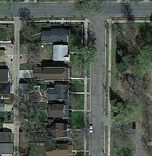
9 MCRAE LOCATION AND HISTORY McRae Park occupies most of a large block bounded by 46th Street, 47th Street, Chicago Avenue, and the Hope Street for Runaway and Homeless Youth. The busy streets on the north and west make this a prominently situated park just north of Minnehaha Creek. Unlike many parks, it is not surrounded by neighborhoods, but rather the semi-commercial avenues of Chicago and 46th, the forested campus of the Children s Home, and the large St. Mary s Cemetery across 46th to the north. The land for McRae Park was obtained partly through purchase by condemnation and partly from the state of Minnesota. A 1944 study of the city s park needs recommended that two playground parks be added to this southern section of the city, but no sites were available or a ordable at the time. In 1946, however, a neighborhood group, the Shenandoah Playground Association, asked the park board to consider a site at 46th and Elliot for a park. Several parcels of land were on the state s tax-forfeiture list. The park board asked the state to withhold those lots from its land sale and added to them by purchasing adjoining land. Plans to develop the park into a playground and athletic elds were completed in 1953, as were special assessment procedures to bill area property owners for the costs of developing the park. Construction of the park began in late 1954 and was completed in The new park had baseball, softball, and football elds, a hard-surface area for basketball and volleyball, two tennis courts, a concrete wading pool, a small playground shelter and warming house, playground equipment, sidewalks, and picnic tables. The park was named in 1955 for Alexander A. McRae, a banker who served as a park commissioner for 18 years and was the board s president He died during his second stint on the park board in 1944 at age 74. New playground equipment was installed at McRae in 1969 at the beginning of a cycle of major improvements to park facilities throughout the city in the 1970s. Seven years later, the original small park shelter was expanded into a recreation center. A new play area for small children was added in 1996, and in 1998 a permanent hard-surface skating rink was constructed that permits year-round skating, in winter on blades and in summer on wheels. EXISTING CONDITIONS AND CHARACTER As a fairly recent addition to the Minneapolis park system, McRae Park today is not much di erent than it was after its original implementation. It features three multi-use diamonds and a year-round rink (ice in winter, paved in summer) on its four main corners, with a 145 football eld complete with goalposts in the center. Near the recreation center are two playgrounds and a wading pool, with a picnic area and sand volleyball court just to the east. A small parking lot is accessible from 47th Street on the southern edge of the park. The southwest corner of the McRae block is occupied by several commercial businesses, this land having never been purchased by MPRB. North of these businesses along Chicago Avenue are horseshoe courts, a full court basketball court, a hard-court volleyball court, two tennis courts, and a half-court tennis bang-board. The fringes of the sports areas are pleasantly shaded by large conifer and deciduous trees, but few walking paths allow for accessible strolls through the park. McRae Park has been known for its year-round sports programs. In winter, two broomball rinks are erected here in addition to the permanent hockey rink. In summer softball, football, and soccer use the elds most nights and weekend days. A capital improvement project underway at the time of the SSAMP process is improving the multi-use elds with new soil, grass, irrigation, and improved drainage. CONNECTIONS BETWEEN PARKS Way nding and connections from McRae Park should focus on: The Southside Greenway, which is planned to run one block west of the park on Columbus Avenue. An obvious connection to this proposed City of Minneapolis facility would connect McRae to Minnehaha Creek, Pearl Park, Phelps Field, and Powderhorn Park. A proposed pedestrian and/or bicycle route along 47th Street eastward to Nokomis- Hiawatha Regional Park and to Minnehaha Creek via 17th Avenue. CH 4 NEIGHBORHOOD PARK PLANS MCRAE
10 UPDATE EXISTING Existing Conditions: McRae 146

11 CH 4 NEIGHBORHOOD PARK PLANS MCRAE MC YR E 47TH ST CHICAGO AVE S Proposed Plan: McRae
12 THE PROPOSED DESIGN The design for McRae Park recogni es the community desire for an active, sports-oriented park with improved amenities. The plan follows the capital project s recommendation for an improved multi-use eld in the center of the park (with removal of the football goalposts), and relocation of broomball rinks o that eld in the winter. The SSAMP plan also reduces the number of multi-use diamonds from three to two, on the northwest and southeast corners, to allow more space for broomball and other eld sports. The parking lot is extended eastward to nearly double its si e, to accommodate the sports use and the fact that parking along Chicago and 46th is sometimes unavailable (unlike in other parks where on-street parking is easy to come by). To accommodate this move, the wading pool and play areas are relocated slightly, to the northeast of the proposed lot extension. A picnic area and sand volleyball court are retained at the southeastern-most edge of the park. The parking lot, upon its expansion, should consider sustainable construction methods and stormwater management, per the recommendations in this plan. The court sports area along Chicago Avenue is modi ed. The horseshoe, hard volleyball, and tennis bang-board courts are eliminated in favor of two fullcourt basketball courts and several shoot-hoops of varying heights, to allow for play by younger children or OPERATION ESTIMATE general basketball practice. The two tennis courts are reconstructed as multi-use courts focusing on tennis, pickleball, and volleyball. Naturali ed areas with pollinator-friendly plantings trace the outer edges of the park, while new pathways allow for walking loops around the park and improved accessible connections to surrounding streets. McRae Park has a lot of sporting activities packed in, and this active focus will continue in the future. In addition to football, baseball, basketball, soccer, hockey, broomball, and other sports, McRae visitors will now be able to stroll around the park from activity to activity even nding more safe places to park when they come. KNOWN LAND USE AND COORDINATION ISSUES There are no known land use or coordination issues with McRae Park. During the planning process, some community members suggested that MPRB should complete the square and acquire the properties on the southwestern corner. This was not adopted into the nal plan, however, as acquisition priorities lie elsewhere and the park design was able to incorporate most desires into its existing extents. UPDATE EXISTING YR MC Traditional Play Structure Wading Pool Volleyball Court Basketball Court Broomball Rink Year-round Rink Multi-use Field Multi-use Diamond NEW/ ADDED Multi-sport Court Basketball Court Walking Loop Trail 148
13 PROCESSES aquatics 1: General Input 2: Initial Concepts 3: The Preferred Concept Spring-Fall 2015 Fall-Winter 2015/2016 Now Wading pool generally disliked Provide shade at pool Splash pad with shade structure instead of wading pool, closer to fields than existing, to allow room for expanded parking play Play equipment is in poor condition no comments Traditional play equipment relocated closer to fields than existing, to allow room for expanded parking athletics Multi-use diamonds generally disliked; field quality is seen as poor overall no comments Removal of one multi-use diamond to create larger multiuse field space and to prevent overlap with broomball rink Tennis courts are well used Basketball, tennis both popular Tennis courts retained in same number and location courts Basketball courts need improvement, but this use is desired in the park Sand volleyball is heavily used by Latino population Replacement of basketball and horseshoe area with two fullcourt basketball, four shoot hoops at varying heights, and seating area under shade for courts area Sand volleyball court retained in same general location, near picnic area in southeast corner winter landscape other Hockey and broomball rinks are heavily used in this park no comments specific to McRae; many comments want more natural areas in parks no comments no comments specific to McRae; many comments want more natural areas in parks Permanent ice rink retained in same location. Two broomball rinks relocated to eliminate overlap with football field Addition of naturalized areas around perimeters of park no comments Like expanded parking Parking expanded to the east Need on-site storage for sports and maintenance equipment Provide picnic area Addition of walking trails throughout the park Enhanced picnic area near play area in southeast corner of park CH 4 NEIGHBORHOOD PARK PLANS MCRAE 149
14 COST ESTIMATE Asset Type Project 2017 ESTIMATED COST/PROJECT Implementation Sequence Prioritization Category Applicable SSAMP Actions Aquatics Wading Pool, $ 911,712 PLANNED 16 Play Traditional Play Structures (2) in new container $ 698,158 FUNDED 16, 23b, 23d Athletics Athletic field renovation, $ 1,162,228 FUNDED/PLANNED 16, 21a, 21b, 21d Courts Multi-use Court (2) $ 213,554 PLANNED 16, 18, 22c Courts Basketball Court (2) + shoot hoops $ 344,972 PLANNED 16, 22a Courts Volleyball Court $ 57,495 PLANNED 16 Winter Hockey/Inline Skate Rink $ 246,409 PLANNED 16, 18 Landscape Naturalized areas $ 42,136 Landscape Parking Lot Renovation and expansion $ 331,899 Other PLANNED 26, 29 PLANNED 28 Gathering Space/Plazas $ 133,882 PLANNED 16 Other Renovate walking paths $ 174,786 Other Miscl. signs, trees, furniture $ 77,873 TOTAL $ 4,395,104 PLANNED 16, 17 PLANNED 9, 10,
15 MERIDIAN GARDEN ABOUT Meridian Garden is considered a special case in the SSAMP process. It is a community garden operated by the Bancroft Neighborhood and community volunteers. It was not master planned during the SSAMP process because it has a special use that MPRB does not intend to change. In fact, the parcel is parkland only as a way to ensure no other use can be built there. MPRB has no management responsibility for the land, and acts essentially as a title-holder for the community-driven work that happens there. The garden began in 1996 on a foreclosed lot on the corner of 38th Street and 12th Avenue in the Bancroft Neighborhood (which, incidentally, is one of very few neighborhoods in Minneapolis without a park). In 2006, at the request of the neighborhood, MPRB became owner of the land to preserve its use as a garden. KNOWN LAND USE AND COORDINATION ISSUES No known land use and coordination issues exists, though the site is managed by an outside organi ation. CH 4 NEIGHBORHOOD PARK PLANS MERIDIAN GARDEN 151
16 This page was intentionally left blank
17 MORRIS LOCATION AND HISTORY Morris Park occupies a single city block bounded by 55th Street, 40th Avenue, 56th Street, and 39th Avenue in the far southeastern corner of Minneapolis. The southernmost portion of the park sits across a vacated portion of 39th Avenue from an elementary school currently operated by the Hiawatha Leadership Academy. The former public elementary school Morris Elementary gures prominently in the park s history. Morris Park was purchased by condemnation in 1956, but it appeared long before then in park board deliberations. A potential Morris Park rst appeared in the form of a protest from the Morris School PTA against a resolution by the park board to acquire three park sites in the portion of Minneapolis that was annexed from Rich eld in One site the park board considered was at 59th Street and 27th Avenue, southwest of the present Bossen Field, land that is now owned by the airport. The Morris Park PTA wanted a park nearer the school. After much debate over the location of a park in the vicinity, the issue was rendered moot by the park board s abandonment in 1931 of all e orts to acquire any parks in the newest section of the city that was annexed from Rich eld. Property owners were not willing to be assessed for the acquisition or improvement of any of the proposed sites, perhaps understandable given the onset of the depression. Later, in 1938, an internal park board survey of neighborhoods that needed playgrounds identi ed the Morris Park neighborhood as one where a playground was recommended for future development. During the economic recovery of the 1950s, and after successful collaboration by the park board and school board in building parks and schools jointly at Waite Park and Armatage Park, the two boards considered another cooperative venture at Morris School in The addition of a park to the school grounds got a green light in 1955 as a special assessment project, meaning that property owners in the neighborhood would be assessed the costs of acquiring and improving the land for a park. The land was acquired in 1956 and work began on the park. The park acreage was augmented by 1.7 acres of land owned by the school board adjacent to the school. The land acquired was not vacant land, so homes had to be moved before construction could begin. A shelter was built at the park in 1957 similar to the design pioneered at Franklin Steele Square with garage-door like exterior walls that could be raised in summer and lowered in winter to provide a warming house. In addition to the shelter, the park board installed ball elds, a hard-surfaced play area, a wading pool, and playground equipment. Morris Park was the subject of political wrangling in The park board added an expansion of the Morris Park shelter to its 1980 bond program request. The mayor vetoed the expenditure, but the park board voted unanimously to override the veto. Despite the assertion of its independence from the mayor, the park board did not get its way when the city council did not approve the bond request. 153 The park board did obtain city bond funds, as well as grants from the state, to renovate the park in 1985 and Finally in 1993 and 1994, the funds were provided for the expansion of the old portable-wall shelter at Morris Park into a small, modern recreation center. One of six skate parks in city parks was installed in 2005 and new playground equipment was installed in Morris School, for which the park is named, closed as a public school in The building reopened in 2009 as the Hiawatha Leadership Academy, a public charter school. EXISTING CONDITIONS AND CHARACTER The Morris Park Recreation Center sits in the center of the park. A small circular parking lot with somewhat steep and awkward grades connects from 39th Avenue to the west of the building. To the north is a wading pool anked on both sides by playgrounds. A small but lovely picnic area under mature trees fronts 55th Street. To the east of the building are a horseshoe court and a skatepark, which was constructed over the top of a former basketball court. The athletic elds to the south of the building are small, featuring just one multi-use Diamond with multi-use eld space available in the out eld. The school lies to the west of the athletic elds and fronts just the southern portion of the park (the northern portion of the block has single-family residences). Dividing the park and school is a vestige of 39th Avenue. The useable part of the road stretches southward from 55th Street and ends at a fence near the southern entrance to the park parking lot. The road pavement, however, continues all the way through to 56th Street, where it also fenced. A portion of this pavement is used for school parking and also for recess games. This portion of 39th Avenue has been vacated, meaning the park/school property line runs down its middle. Needless to say, an old road is probably not a desirable park feature. With the reestablishment of a school adjacent to Morris Park, the site is again active during the day. Otherwise, it serves as a peaceful through well used neighborhood center. The skatepark attracts users, though many feel it s quality could be improved. CH 4 NEIGHBORHOOD PARK PLANS MORRIS
18 Existing Conditions: Morris 154

19 40TH AVE S E 55TH ST MC E 56TH ST LG Proposed Plan: Morris 39TH AVE S NOTE: School-owned Property CH 4 NEIGHBORHOOD PARK PLANS MORRIS 155
20 CONNECTIONS BETWEEN PARKS Way nding and connections from Morris Park should focus on: The existing City of Minneapolis bicycle/ pedestrian route along 56th Street, which connects to the west to Bossen Field and Nokomis-Hiawatha Regional Park. Because Morris Park is relatively small and does not have extensive athletic facilities, a connection to Bossen Field could help ll this need. THE PROPOSED DESIGN In coordination with the Hiawatha Leadership Academy, the master planning process considered all the land between the school and the park, disregarding the school/park property line for planning purposes. More green space and an improved connection to the park are desired by the school, which is also not enamored with the leftover road. The road is removed in the plan, and new trail connections link the eastern school entrance and the recreation center and playgrounds. A small court games area (four square, hopscotch, etc.) is located along the path near the school entrance. The athletic elds are largely unchanged, except that the removal of the road allows for a youth-si e soccer eld to t in the multi-use diamond s out eld. Small picnic and gathering areas ll the corners of the sports area, o ering options for community members and teachers with their students to be outside under trees. Nearer the recreation center, the parking lot and entry area is revised to create a more compact and welcoming building access. Between the parking lot and building is a pla a with seating to allow for community gathering and conversation. The seating could be movable or custom built, creating interesting spaces amongst new and existing trees. The wading pool is reconstructed in the same place, with a new shade arbor reaching north from the recreation building. The play areas are moved to the western side of the wading pool, to bring them closer together and make room for other amenities to the east. The skatepark remains but is improved, and a new multi-use court sits just to the north. This court would be primarily used for basketball, but could also be designed with removable standards for tennis, pickleball, volleyball, and/or badminton At the far northern end of the park, the picnic area in the woods remains, but new pollinator-friendly landscaping along 55th Street further enhances the sense of enclosure and calm. Morris Park is a little gem in far southeastern Minneapolis, unsung city-wide but so important to the neighborhood. The basic bones of the park are as before, but a more e cient use of space allows for additional amenities for both neighborhood children and school children. KNOWN LAND USE AND COORDINATION ISSUES Some planned amenities cross the property line between school and park property. Coordination with Hiawatha Leadership Academy will be necessary to implement certain improvements in partnership. Based on discussions with HLA, is seems that MPRB and HLA goals are in alignment. Discussions about implementation should commence when feasible. OPERATIONS ESTIMATE UPDATE EXISTING LG Traditional Play Structure Wading Pool Multi-use Field Multi-use Diamond Skate Park NEW/ ADDED MC Outdoor Gathering Space Multi-sport Court Lawn/Court Games 156
21 PROCESSES aquatics wading pool is used often no comments Wading pool with shade structure in generally the same location no comments Two separate play areas is desired Traditional play areas relocated to west side of park. play Like two play areas on same side of building, for easy monitoring and access to school. athletics no comments Preference for multi-use field: more flexibility of use, especially for the school. Multi-use diamond retained in existing location. Paved area between park and school removed to create space for multi-use field. no comments Like bringing back basketball Skate park retained and enhanced in existing locstion. other landscape winter courts Addition of full court basketball/multi-use court adjacent to skate park. Addition of court games area between park and school. no comments no comments No formal winter facilities planned for this park. no comments specific to McRae; many comments want more natural areas in parks no comments Would be nice to have a small paved area near the school for court games, especially in winter. no comments specific to McRae; many comments want more natural areas in parks The skate park needs improvement, and a surface other than asphalt. Mixed comments on removal of horseshoe pit Addition of naturalized area at northeast corner near basketball court. Improved walking connection between park and school. Addition of picnic areas at edges of multi-use field. Modification of parking lot and building entry to create gathering space. CH 4 NEIGHBORHOOD PARK PLANS MORRIS 157
22 COST ESTIMATE Asset Type Project 2017 ESTIMATED COST/PROJECT Implementation Sequence Prioritization Category Applicable SSAMP Actions Aquatics Wading Pool, $ 739,226 PLANNED 16 Play Traditional Play Structures (2) in new container $ 698,158 PLANNED 16, 23b, 23d Athletics Athletic field renovation, $ 593,024 PLANNED 16, 21b, 21d Courts Basketball Court $ 106,777 PLANNED 16, 22a Landscape Naturalized areas $ 9,980 PLANNED 26, 29 Landscape Parking Lot Renovation $ 66,490 PLANNED 28 Other Skate Park $ 410,681 PLANNED 16, 18 Other Court Games $ 81,808 PLANNED 16 Other Building Plaza $ 140,617 PLANNED 16 Other Skatepark / Basketball Plaza $ 25,462 PLANNED 16 Other Renovate walking paths $ 145,361 Other Miscl. signs, trees, furniture $ 53,586 n/a Agreement with school for collaboration on capital improvements $ - TOTAL $ 3,071,170 PLANNED 16 PLANNED 9 PLANNED
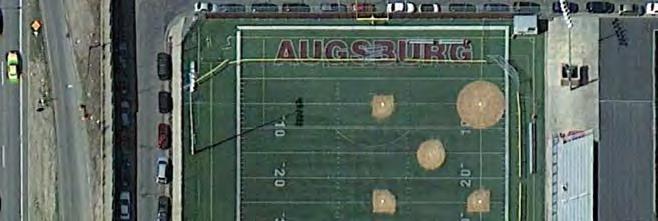
23 MURPHY SQUARE LOCATION AND HISTORY Murphy Square is, yes, a square completely surrounded by the Augsburg University Campus in the Cedar- Riverside neighborhood just north of I-94. It is bounded by 7 ½ Street, 23rd Avenue, Butler Place, and 22nd Avenue. It sits just west of the Augsburg football stadium and just north of a pedestrian bridge across I-94 that connects to the Seward Neighborhood. Murphy Square is Minneapolis s rst park. It s was named for Edward Murphy, who donated the land for a park when he platted Murphy s Addition in (The name was o cially changed from Murphy Park to Murphy Square in 1890.) Parks were in the news in 1857: New York City conducted a competition to design its vast Central Park, one of the most important developments in the creation of urban parks in the country s history. That event may have in uenced Murphy s establishment of a park on land he was developing. Murphy Park was a long way from the center of the small towns of Minneapolis and St. Anthony at the time and the land served as little more than a cow pasture for twenty years. In 1873 Murphy attempted to get the city council to pay to improve the land. Trees were planted in the park, perhaps under the direction of Charles Loring, who is said to have planted the rst trees in Minneapolis and was a city council member at the time. The park was transferred from the city council to the new park board shortly after the park board was created in April The park board hired Landscape architect Horace Cleveland to create a plan for the park in late Murphy Square was one of several parks immediately improved by Theodore Wirth when he was hired in He implemented additional plantings and changed some of the paths in the park. An artesian well was also dug at Murphy Park that year, but the city condemned as un t the water produced by the well. Murphy Square was one of the parks recommended as a playground in 1906, when the park board installed its rst playground equipment, and a merry-go-round was installed in A tennis court was built at Murphy Square in 1917, but it was removed in 1919 with the explanation that there wasn t su cient space for it. Some residents of the neighborhood petitioned the park board to install a kittenball (softball) eld in the park in 1922, but opposition from other property owners led the park board to reject the idea. With the growth of Augsburg College, Murphy Square became, in essence, a central square for the college. The park board entered into serious negotiations with 159 the school to sell the square to the college in When those negotiations were unsuccessful, the park board included Murphy Square on a list of properties it could part with, for housing purposes, in In 1975, the park board considered a land swap with Augsburg College that would have transferred the park to the college, but once again the city s oldest park remained a park. Ultimately, only a small piece of Murphy Square was lost, and that was due to the construction of the I-94 freeway, which nipped o a bit of the park in the 1960s. EXISTING CONDITIONS AND CHARACTER Today, Murphy Square is, essentially, Augsburg s central quad. Most park users are students, and many students move through the park from one class to another. Picnic tables are scattered throughout and are used for individual and group studying. There are no active recreation facilities in the park. MPRB currently has an operating agreement with Augsburg University that tasks the college with maintenance and allows it to program the park. MPRB has little responsibility for the park other than ownership and potentially capital investment. Augsburg has prepared a long-term master plan that it is implementing over time. The master plan envisions improvements to Murphy Square. CONNECTIONS BETWEEN PARKS Way nding and connections from Murphy Square should focus on: A connection through the college campus to the City of Minneapolis bicycle/pedestrian route on Riverside Avenue CH 4 NEIGHBORHOOD PARK PLANS MURPHY SQUARE
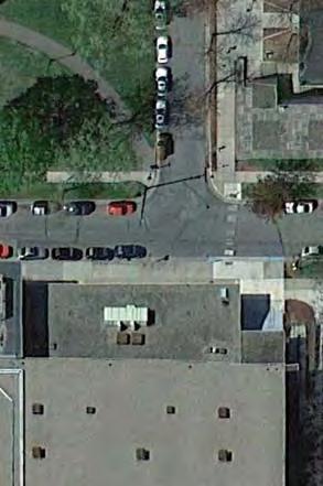
24 Existing Conditions: Murphy Square 160

25 NEW/ ADDED Group Shelter S 7 1/2 ST Outdoor Gathering Space 22ND AVE S Proposed Plan: Murphy Square BUTLER PL S 23RD AVE S THE PROPOSED DESIGN The plan for Murphy Square reinforces the current pathway layout, but makes some modi cations based on both the Augsburg Master Plan and discussions with Augsburg facilities sta. East-west circulation in the park is simpli ed with a linear double walkway, to allow easy transit from one side of campus to the other. This walkway is lined with small shelters, study kiosks and nooks, and outdoor desks potentially equipped with charging stations and wi-. This pathway becomes a study corridor, o ering varied opportunities for college students to get outdoors and learn. Several smaller paths are added to improve circulation within the park, and two central paths reaching south from the center of the park are removed. This creates a larger open space without trees, to allow for impromptu games of frisbee, football, soccer, and whatever else. The center of the park would be a great location for a signi cant public artwork. As Minneapolis s rst park, Murphy Square should remain a park and be available to the general public. The fact is, however, that it will mostly be used by the college. The plan therefore, improves its function as a quad, with unique study areas, easy circulation, and open space for games. KNOWN LAND USE AND COORDINATION ISSUES At the time of the SSAMP process, the agreement with Augsburg University was about to expire. MPRB and Augsburg should renew the agreement with an eye to capital improvement associated with the campus master plan. CH 4 NEIGHBORHOOD PARK PLANS MURPHY SQUARE 161
26 PROCESSES 1: General Input 2: Initial Concepts 3: The Preferred Concept Spring-Fall 2015 Fall-Winter 2015/2016 Now aquatics no comments no comments No aquatic facilities planned for this park play no comments no comments No formal play facilities planned for this park athletics no comments no comments No formal athletic facilities planned for this park courts no comments no comments No courts planned for this park winter no comments no comments No formal winter facilities planned for this park landscape Augsburg College has a long-term master plan that shows some changes to Murhpy Square Like opening up of southern green space for impromptu games and gathering Addition of east-west pathway, in consideration of campus master plan, and several other paths to improve circulation within and through park Augsburg design shows a major eastwest pathway to connect the campus Removal of some paths in the southern half of the park to create open gathering / play area other no comments Like inclusion of study areas for students, consider internet access, good work tables, etc. Addition of study shelters along main east-west pathway 162
27 COST ESTIMATE Asset Type Project 2017 ESTIMATED COST/PROJECT Implementation Sequence Prioritization Category Applicable SSAMP Actions Other Study shelters $ 361,400 with some path renovation CONTINGENT 16, 17 Other Public Art $ - stand-alone CONTINGENT 16 Other Renovate walking paths $ 274,821 stand-alone CONTINGENT 16, 17 Other Miscl. signs, trees, furniture $ 11,025 n/a with other projects, as appropriate CONTINGENT 9 Agreeement with Augsburg that addresses capital improvements $ - stand-alone PLANNED 15 TOTAL $ 647,246 NOTE: Implementation of the study shelter and public art is dependent on leadership by Augsburg. OPERATIONS ESTIMATE CH 4 NEIGHBORHOOD PARK PLANS MURPHY SQUARE 163
28 This page was intentionally left blank
.")
29 NORMANNA TRIANGLE LOCATION AND HISTORY Normanna Triangle is a sliver of land bounded on two sides by Minnehaha Avenue and 21st Avenue and on the north by a multi-family housing complex. It is one of several oddly shaped parcels of land that occur where the diagonal of Minnehaha Avenue intersects the regular city grid (the other two are Adams and Rollins Triangles). The park board asked the city council to turn over the triangle to the park board in In the following year the park board approved unspeci ed improvements for the triangle. Its name was suggested to honor the Norwegian ancestry of many residents of the neighborhood. The name was o cially adopted on December 27, It had previously been referred to as Minnehaha Avenue Triangle. Though there is not much history that can be associated with such a small parcel, Normanna Triangle nevertheless was involved in an interesting discussion over drinking water wells on park property. Residents of the area had requested a well in the triangle, and the request was approved in However, the well must not have been installed because residents asked for a well again in On November 18, 1914 the Committee on Improvements reported in regard to that request that since the Board is not permitted under the State Law to have drinking cups for the use of the patrons of the parks and the city water is now suitable for drinking purposes it seems unwise to continue the placing of wells where the city water is available. Curiously, given that apparently sound logic, the park board responded favorably to another request for a well at Normanna Triangle the following year and in February 1916 went a step further, authori ing wells for not only Normanna Triangle, but also Bryant Square and Lovell Square. EXISTING CONDITIONS AND CHARACTER There is no well at Normanna Triangle. The park is a swath of mown turfgrass with a sidewalk near its northern end and a few benches and a sign. A fence separates the park property from the housing to the north. CH 4 NEIGHBORHOOD PARK PLANS NORMANNA TRIANGLE 165
30 Existing Conditions: Normanna Triangle 166

31 CONNECTIONS BETWEEN PARKS should focus on: The City of Minneapolis bicycle and pedestrian route being implemented on Minnehaha Avenue A community-desired trail connection along 22nd Street, which would pass through the park and connect to the Hiawatha Trail to the west and through the neighborhood to Matthews Park to the east. THE PROPOSED DESIGN are planned at Normanna Triangle. The main change is a bicycle trail crossing the northern edge of the park and functioning as an extension of 22nd Street. This path is separated from the pedestrian sidewalk to increase safety. Additional benches, trees, and pollinator-friendly plantings in the northern portion of the park will encourage users to linger for a moment. Public art could be incorporated into this area, as well. Proposed Plan: Normanna Triangle KNOWN LAND USE AND COORDINATION ISSUES Hennepin County, in its examination of roadways around the intersection of Franklin Avenue, Cedar Avenue, and Minnehaha Avenue just to the north, has envisioned modifying 21st Avenue so that it curves across the southern tip of Normanna Triangle and enters Minnehaha Avenue at a right angle. This idea is also supported by the neighborhood. At the time of the was planned. However, the concept street design Triangle. Coordination with the County may allow for some improvements to be made in exchange for land, if needed. CH 4 NEIGHBORHOOD PARK PLANS NORMANNA TRIANGLE 167
32 PROCESSES 1: General Input 2: Initial Concepts 3: The Preferred Concept Spring-Fall 2015 Fall-Winter 2015/2016 Now aquatics no comments no comments No aquatic facilities planned for this park play no comments no comments No formal play facilities planned for this park athletics no comments no comments No athletic facilities planned for this park courts no comments no comments No courts planned for this park winter no comments no comments No formal winter facilities planned for this park landscape no comments Pollinator garden and fruit trees Addition of naturalized area or garden at northern edge along pathways no comments Ped/bike path across triangle aligned on 22nd Street Addition of separate bike and pedestrian paths across northern edge, including seating along pedestrian path other Picnic gathering area Public art would be a good addition here 168
33 COST ESTIMATE Asset Type Project 2017 ESTIMATED COST/PROJECT Implementation Sequence Prioritization Category Applicable SSAMP Actions Landscape Naturalized areas $ 1,207 PLANNED 26, 29 Other Walking and bicycle paths $ 15,770 PLANNED 8 Other Miscl. signs, trees, furniture $ 5,405 PLANNED 9 TOTAL $ 22,383 OPERATIONS ESTIMATE There will be NO maintenance change at this Park. CH 4 NEIGHBORHOOD PARK PLANS NORMANNA TRIANGLE 169
34 This page was intentionally left blank
and plant some trees, but that was only accomplished through state and federal work-relief programs.
 PEAVEY LOCATION AND HISTORY Peavey Park sits in the Phillips Community on a large block bounded by major streets: Franklin Avenue, Chicago Avenue, and Park Avenue. The southern continue through to Chicago
PARK PLANS SECTION CONTENTS: INTRODUCTION KEY/LEGEND PARK PLANS & COST ESTIMATES
 PARK PLANS SECTION CONTENTS: INTRODUCTION KEY/LEGEND PARK PLANS & COST ESTIMATES This page was intentionally left blank PROCESSES INTRODUCTION The South Service Area Master Plan creates unique new designs
PARK PLANS SECTION CONTENTS: INTRODUCTION KEY/LEGEND PARK PLANS & COST ESTIMATES
 PARK PLANS SECTION CONTENTS: INTRODUCTION KEY/LEGEND PARK PLANS & COST ESTIMATES This page was intentionally left blank PROCESSES INTRODUCTION The South Service Area Master Plan creates unique new designs
CLEVELAND PARK LOCATION AND HISTORY EXISTING CONDITIONS AND CHARACTER LOCATION
 CLEVELAND PARK LOCATION LOCATION AND HISTORY Attempts to create a neighborhood park and playground in the Cleveland neighborhood began in 1926, when the park board designated for acquisition the block
NORTH OF BROADWAY SECTION CONTENTS: COTTAGE PARK FARVIEW PARK GLEN GALE PARK IRVING TRIANGLE JORDAN PARK NEWTON PARK PERKINS HILL PARK
 NORTH OF BROADWAY SECTION CONTENTS: COTTAGE PARK FARVIEW PARK GLEN GALE PARK IRVING TRIANGLE JORDAN PARK NEWTON PARK PERKINS HILL PARK N ILIO NA VE N JAM ES AV E PLAYGROUND PAR K PRO PER TY B OUN DAR Y
NORTHWEST SECTION CONTENTS: CLEVELAND PARK FOLWELL PARK RYAN LAKE PARK VICTORY PRAIRIE DOG PARK VICTORY PARK
 NORTHWEST SECTION CONTENTS: CLEVELAND PARK FOLWELL PARK RYAN LAKE PARK VICTORY PRAIRIE DOG PARK VICTORY PARK LUCY LANEY COMMUNITY SCHOOL N 33RD AVE N 33RD AVE SINGLE-FAMILY RESIDENTIAL MULTI-USE DIAMOND
BASSETTS CREEK SECTION CONTENTS: BASSETTS CREEK BRYN MAWR LUCE LINE
 BASSETTS CREEK SECTION CONTENTS: BASSETTS CREEK BRYN MAWR LUCE LINE GLENWOOD AVE MULTI-USE DIAMONDS VINCENT AVE N MORGAN AVE N PENN AVE N DOG PARK MULTI-USE FIELDS PLAYGROUND AK E RD S CHESTNUT AVE DA
WEST CENTRAL SECTION CONTENTS: FARWELL PARK NORTH COMMONS PARK OLIVER TRIANGLE RUSSELL PARK THEODORE WIRTH REGIONAL PARK VALLEY VIEW PARK WILLARD PARK
 WEST CENTRAL SECTION CONTENTS: FARWELL PARK NORTH COMMONS PARK OLIVER TRIANGLE RUSSELL PARK THEODORE WIRTH REGIONAL PARK VALLEY VIEW PARK WILLARD PARK FARWELL PLACE THOMAS AVE N SWING BENCH PICNIC AREA
FOLWELL PARK LOCATION AND HISTORY LOCATION
 FOLWELL PARK LOCATION LOCATION AND HISTORY Folwell Park is a large (by neighborhood park standards) tract of land located south of Dowling Avenue between Humboldt and Knox Avenues. The land for the park
EXISTING CONDITIONS AND CHARACTER
 DEMING HEIGHTS PARK LOCATION AND HISTORY Located in the Audubon Park neighborhood, Deming Heights Park is surrounded by a residential area. The first land for the park was acquired in 1913 along with the
PIONEER PARK. City of Des Peres Parks Master Plan. SWT Design 46 INTRODUCTION
 PIONEER PARK INTRODUCTION Pioneer Park is a 7 acre neighborhood park located east of Interstate 270 and south of Manchester Road along Tallie Road. The park is situated in a residential neighborhood with
SHINGLE CREEK SECTION CONTENTS: BOHANON PARK CREEKVIEW PARK SHINGLE CREEK PARK SHINGLE CREEK REGIONAL TRAIL WEBBER PARK
 SHINGLE CREEK SECTION CONTENTS: BOHANON PARK CREEKVIEW PARK SHINGLE CREEK PARK SHINGLE CREEK REGIONAL TRAIL WEBBER PARK SPLASH PAD Good condition. PARK BUILDING BRYANT AVE N Good condition and unique to
HALL PARK LOCATION AND HISTORY EXISTING CONDITIONS AND CHARACTER LOCATION
 HALL PARK LOCATION LOCATION AND HISTORY Hall park straddles Lyndale Avenue on the city s near north side. This neighborhood was identified in a 1938 study of the city s playground needs as one of five
2. Goals and Policies. The following are the adopted Parks and Trails Goals for Stillwater Township:
 D. PARKS AND TRAILS 1. Introduction Stillwater Township s population is relatively low, with most residents living on rural residences on large lots. The need for active park space has been minimal in
Community Advisory Committee Meeting #3 April 21, 2015
 Community Advisory Committee Meeting #3 April 21, 2015 Purpose (charge) of the CAC: Be Knowledgeable, Be an Engaged Representative, Develop Master Plan, & Prioritize Plan 1 Welcome/ Introductions Review
Chapter 6. Action Program. Heart of the Lakes Area Recreation Plan
 Heart of the Lakes Area Recreation Plan 1. Design and construct the following trails (please see the following map): a. the Speedway Trail 1) primary pathway the main trail 2) secondary pathway the proposed
M E S T I Z O C U R T I S P A R K
 ARAPAHOE CONNECTION TO BUS ROUTE AT ND AND LAWRENCE, FUTURE LIGHT RAIL STATION LEGEND SOCIAL TRAIL FLAGSTONE PAVING TO RESTORE/MAINTAIN CONCRETE PAVING DIAGONAL CURVILINEAR SOCIAL ROUTE IS OUT OF HISTORIC
Northeast Quadrant Distinctive Features
 NORTHEAST QUADRANT Northeast Quadrant Distinctive Features LAND USE The Northeast Quadrant includes all the area within the planning area that is east of Interstate 5 and to the north of State Route 44.
Nelson/Tasman Recreation Cross Boundary Partnerships. Presented by Richard Kempthorne Mayor Tasman District
 Nelson/Tasman Recreation Cross Boundary Partnerships Presented by Richard Kempthorne Mayor Tasman District Presentation in two parts Regional Communities Facilities Plan Regional Communities Facilities
NEW MEADOWS PARK PROPOSED MASTER PLAN
 NEW MEADOWS PARK PROPOSED MASTER PLAN A vision for your neighborhood park, the draft master plan is ready for your review. Tuesday September 12 th, 2017 5:30-7:00 PM Hellgate School District #4 middle
APPENDIX E: SUMMARY OF PUBLIC MEETING QUESTIONNAIRE RESULTS
 Appendices Gwinnett County 2004 Comprehensive Parks and Recreation Master Plan APPENDIX E: SUMMARY OF PUBLIC MEETING QUESTIONNAIRE RESULTS March 2004 Monteith Brown Planning Consultants & The Jaeger Company
Trail Etiquette. Hours of Operation. Trail Accessibility
 Trail Guide The Elmhurst Park District, with 28 parks and over 460 acres of land, offers nearly six miles of paved or asphalt park trails and maintains an additional 3.6 miles of trails within Elmhurst.
Southwest Quadrant Distinctive Features
 SOUTHWEST QUADRANT Southwest Quadrant Distinctive Features LAND USE The 31.17 square mile Southwest Quadrant includes all the area within the planning area west of I-5 and south of the Sacramento River.
City of Galion Park Satisfaction Survey Results
 City of Galion Park Satisfaction Survey Results Dec. 5, 2016 Goal: To get feedback from the community on: 1. General satisfaction of city-owned parks 2. How to improve park facilities and recreation opportunities
PARKS & BEACHES PROJECTS
 #18 72ND STREET PARK, LIBRARY, #19 BLUEWAYS & AQUATIC CENTER $1.1 MILLION $60 MILLION New facility to include: Create Kayak Launches with All Wheels Skate Park Floating Docks and Seating at: Library/Media
4MRV Parks Master Plan: Site Analysis
 4MRV Parks Master Plan: Site Analysis Lardner/Klein Landscape Architects in association with: RK&K Grimm + Parker Kittelson & Associates Partners for Economic Solutions RIB U.S.Cost Civil Engineering Architecture
OR MISSION TRAIL ELEMENTARY
 Leawood: overview OVERLAD PARK 24: p.70 I-LA PARK 32: p.72 TOMAHAWK PARK 23: p.69 31: p.71 GEZER PARK OR MISSIO TRAIL ELEMETARY 22: p.68 W 133rd St W 135th St KASAS CITY MO - other segments Beginning/end
Arvidson, Adam R. Adam,
 Arvidson, Adam R. From: Andrew Hestness Sent: Wednesday, May 18, 2016 5:39 PM To: Arvidson, Adam R. Cc: Renee Spillum; Schroeder, Michael Subject: RE: Park Dedication Attachments: FranklinPlan - Bystrom
Chapter eight. Parks and Recreation. Introduction. Crystal Lake Park District
 Chapter eight Parks and Recreation Introduction One of the indicators of quality of life in a city is the parks and recreation system. The City of Crystal Lake is fortunate to have an excellent parks and
Welcome! INTRODUCTION. Tell us what you think! Comment forms are provided for your feedback
 Welcome! Comment forms are provided for your feedback Tell us what you think! INTRODUCTION The City of Salmon Arm s O cial Community Plan (OCP) and its Parks and Recrea on Master Plan (2012) both iden
POLICY & STRATEGIES The Vancouver Park Board approves major changes in Vancouver parks, including the design and development of parks.
 September 8, 2017 TO: Park Board Chair and Commissioners FROM: General Manager Vancouver Board of Parks and Recreation SUBJECT: Brewers Park and Clinton Park Renewal Concept Plans RECOMMENDATION THAT the
China Creek North Park Upgrades and Glen Pump Station. Park Board Committee Meeting Monday, July 10, 2017
 China Creek North Park Upgrades and Glen Pump Station Park Board Committee Meeting Monday, July 10, 2017 Purpose The purpose of this presentation is to: Share the results of the public engagement processes;
Corktown Parks. Public Meeting. City of Toronto
 Corktown Parks Public Meeting City of Toronto 15-04-20 Agenda 1. Reasons for Study 2. Consultation to Date 3. Parks Evaluation 4. Community Context 5. Bright St. Playground 6. Orphans Green (Dog Off Leash)
3. COLTA / HUGA CONNECTIONS - PRELIMINARY
 9 3. COLTA / HUGA CONNECTIONS - PRELIMINARY 3.1 COLTA The Chain of Lakes Trail Association (COLTA) trail, formerly identified as the Chester Spur Line, was completed and opened for use in June 2011. The
Webber Park Master Plan Charrette Summary
 SMALL GROUP #1 - September 29, 2011 Webber Park Master Plan Charrette Summary More trash cans, especially near picnic grounds A year round pool is very needed-physical & mental health are significantly
Park Design and Location Criteria
 Park Design and Location Criteria This section is presented in the interest of assisting park and recreation agencies in the development of a system of parks and recreation areas. A recreation system is
AGENDA MEMORANDUM Community Services Department. CSAB Meeting Date: April 10, 2018
 AGENDA MEMORANDUM Community Services Department CSAB Meeting Date: April 10, 2018 To: Community Services Advisory Board From: Dana A. Souza, Director Date: April 4, 2018 Legislative Quasi-Judicial SUBJECT:
Capital Prioritization
 14 Capital Prioritization 279 279 280 Park & Recreation CAPITAL PRIORITIZATION As described in Chapter 8, the recommendations presented in Chapter 9 are prioritized to provide a guide for future capital
Dover Park Master Plan. Community Design Event Tuesday, May 22, 5 7 pm
 Dover Park Master Plan Community Design Event Tuesday, May 22, 5 7 pm Agenda I. Introduction / Overview 20 minutes II. Small Group Design Activity 60 minutes III. Small Group Report Out IV. Conclusion
City of Haslett. City of East Lansing. City of East Lansing
 Central Park North (Nancy L. Moore Park) Lake Park North Expansion White Park Expansion #2 White Park Expansion #1 County East East Haslett East East TF87-212 Acquisition $90,000.00 Park. TF08-138 Acquisition
Binley Woods Parish Plan - Analysis of Main Survey Responses Section D1 Sports Activities & Play Equipment
 Binley Woods Parish Plan - Analysis of Main Survey Responses Section D1 Sports Activities & Play Equipment Question D1: How often do you use the following? Binley Woods Parish Plan Main Questionnaire 1
Criteria Based System for MPRB Regional Park and Trail Capital Project Scheduling
 Criteria Based System for MPRB Regional Park and Trail Capital Project Scheduling July 19, 2017 Background Beginning with the 2017-2022 Capital Improvement Program (CIP), MPRB used equity-driven metrics
Schachtner Street. Village Park Somerset, Wisconsin
 Schachtner Street Village Park Village Park Schachtner Street Softball Field Lower Terrace Parking Area Baseball Field Upper Terrace Parking Lot Mid Terrace Parking Area Restroom Building Path to Bridge
Dunsmuir Community Park
 Dunsmuir Community Park Master Plan September 2016 ENGAGEMENT SUMMARY #2 Introduction Public engagement is integral to the development of the Dunsmuir Community Park Master Plan. Two park open houses were
CITY OF FOUNTAIN INN PARKS
 CITY OF FOUNTAIN INN PARKS Country Chase Fitness Park The Country Chase Fitness Park is located in the Country Chase neighborhood at 136 Catterick Way. The park is also located adjacent to a section of
Community Input Meeting. Fairgrounds Master Planning Update. January 7, 2016, 7 pm
 Community Input Meeting Fairgrounds Master Planning Update January 7, 2016, 7 pm Fiesta Hall Santa Clara County Fairgrounds 355 Tully Road, San Jose, CA Tonight s Agenda 1) Board of Supervisors Direction
NORTH HEMPSTEAD BEACH PARK MASTER PLAN
 NORTH HEMPSTEAD BEACH PARK MASTER PLAN COMMUNITY DESIGN CHARRETTE Supervisor Judi Bosworth Viviana L. Russell Peter J. Zuckerman Angelo P. Ferrara Anna M. Kaplan Lee R. Seeman Dina M. De Giorgio VISIONING
35 Bee Tree Park Planning Zone 3
 35 Bee Tree Park Planning Zone 3 2701 Finestown Road Visit Date: August 2016 St. Louis County Parks Master Plan Page 1 35 Bee Tree Park 2701 Finestown Road St. Louis County Parks Master Plan Planning Zone
City of Sierra Madre STUDY AREA PROFILE
 City of Madre STUDY AREA PROFILE STUDY AREA ID #112 BASE MAP PARK METRICS WHERE ARE PARKS MOST NEEDED AMENITY QUANTITIES AND CONDITIONS PARK NEEDS FRAMEWORK PROJECT COST ESTIMATES PROJECT REPORTING FORM
Stittsville Parks Information Session
 Stittsville Parks Information Session Amberway Park, Blackstone Park, Bryanston Gate Park & William Bradley Park Thursday, February 8, 2018 Open House 6:30-8:45pm Presentation 7pm Goulbourn Recreation
Wilds. Headwaters. Lakes. Oxbows. Falls
 56 5 4 3 Wilds Headwaters Lakes Oxbows Falls 57 Zones It could be said the on-the-ground essence of this master plan appears within the next 6 pages of this report. As we learned in the preceding Cultural
17 Mathilda Welmering Park Planning Zone 3
 17 Mathilda Welmering Park Planning Zone 3 8301 Mathilda Visit Date: September 2016 St. Louis County Parks Master Plan Page 1 Description: The six acre Mathilda Welmering Park is named for two streets
Airport Planning Area
 PLANNING AREA POLICIES l AIRPORT Airport Planning Area LOCATION AND CONTEXT The Airport Planning Area ( Airport area ) is a key part of Boise s economy and transportation network; it features a multi-purpose
OAKLAND TOWNSHIP PARKS AND RECREATION MILLAGE RENEWAL AUGUST 2, 2016 BALLOT PROPOSAL QUESTIONS & ANSWERS PULL-OUT SECTION (APRIL 21, 2016)
") OAKLAND TOWNSHIP PARKS AND RECREATION MILLAGE RENEWAL AUGUST 2, 2016 BALLOT PROPOSAL QUESTIONS & ANSWERS PULL-OUT SECTION (APRIL 21, 2016) 2007 2016 Millage Accomplishments Timeline in Pull-out The Mission
OAKLAND TOWNSHIP PARKS AND RECREATION MILLAGE RENEWAL AUGUST 2, 2016 BALLOT PROPOSAL QUESTIONS & ANSWERS PULL-OUT SECTION (APRIL 21, 2016) 2007 2016 Millage Accomplishments Timeline in Pull-out The Mission
- Welcome. - Project Next Steps. - Intros. - Public Comment Time. - Guiding Principles Revisited. - Balance in the Service Area
 ST ONY RK VAN p ' LEVf uxr PARK ER CAC Role The appointed CAC for the East of the River Park Master Plan shall: Become knowledgeable about the project and its scope and advise MPRB staff and consultants
WEST JORDAN PARKS, RECREATION AND TRAILS MASTER PLAN Advisory Committee Meeting #2
 WEST JORDAN PARKS, RECREATION AND TRAILS MASTER PLAN Advisory Committee Meeting #2 MONDAY, NOVEMBER 5, 2018, 6:00 P.M.; PARKS DEPT. CONFERENCE ROOM ATTENDEES: Lisa Dean Larry Gardner Duane Harding David
Appendix B - Undeveloped Parks and Existing Parks with Remaining Development Programming
 Appendix B - Undeveloped Parks and Existing Parks with Remaining Development Programming Table of Contents Appendix B - Undeveloped Parks and Existing Parks with Remaining Development Programming Table
Lake Myra County Park. Wake County, North Carolina Community Forum #2 June 12, 2008
 Lake Myra County Park Wake County, North Carolina Community Forum #2 June 12, 2008 Welcome and Introduction Meeting Agenda Welcome Introductions of Project Team Master Plan Process Community Forum #1 Updates
DEMOGRAPHICS AND EXISTING SERVICE
 EXECUTIVE SUMMARY The Central Corridor light-rail transit (LRT) project will open in 2014 and operate between downtown Minneapolis and downtown St. Paul, serving the University of Minnesota and University
SOAR ATHLETIC COMMITTEE
 PASCAGOULA RECREATION COMMISSION MEETING MAY 15, 2017 Mike McElhaney opened the meeting at 6:00 pm. Mike welcomed Bo Cole as a guest. A special meeting was called to review the recommendation being made
4.0 FACILITIES INVENTORY
 4.0 FACILITIES INVENTORY 4.1 PARK LEVEL OF SERVICE STANDARDS (LOS) Based on current City of Longview Parks and Recreation Level of Service (LOS) Standards (Figure G), the City currently has a deficiency
Summary of Small Group Discussion Notes
 THE CORPORATION OF THE CITY OF WINDSOR Parks and Facilities/ Windsor Essex Local Immigration Partnership Community Consultation: Parks for Today-Planning for Tomorrow Dec 9, 2014 Windsor Public Library
LAUREL TRIANGLE LOCATION AND HISTORY LOCATION
 LAUREL TRIANGLE LOCATION AND HISTORY Laurel Triangle is a small triangle in the Bryn Mawr neighborhood, bounded by Cedar Lake Road, Laurel Avenue, and Oliver Avenue. It is a special consideration park
Community Development Committee
 C Community Development Committee For the Metropolitan Council meeting of October 31, 2012 Committee Report Item:2012-316 ADVISORY INFORMATION October 16, 2012 Date Prepared: Subject: Intercity Regional
7 CORNERS SPECIAL STUDY, TASK FORCE MEETING 11/13/2012 PARKS AND RECREATION EXISTING CONDITIONS: HANDOUT #1
 PARKS AND RECREATION EXISTING CONDITIONS: HANDOUT #1 PARKS AND RECREATION EXISTING CONDITIONS: HANDOUT #1 Fairfax County Park Authority Parks (within one mile of Seven Corners) Park Acres Park Facilities
RUSSELL PARK LOCATION AND HISTORY EXISTING CONDITIONS AND CHARACTER LOCATION
 RUSSELL PARK LOCATION LOCATION AND HISTORY Russell Triangle sits surrounded by streets in a neighborhood bounded by Broadway Avenue, Golden Valley Road, and Theodore Wirth Parkway. The small triangle is
Welcome to the future of Terwillegar Park a Unique Natural Park
 Welcome to the future of Terwillegar Park a Unique Natural Park 1 Introduction The Terwillegar Park Concept Plan study will develop an overall concept plan, management objectives and development guidelines
Gardner: overview. Santa Fe, Oregon, and California National Historic Trails UNINCORPORATED JOHNSON COUNTY OLATHE UNINCORPORATED JOHNSON COUNTY
 Santa Fe, Oregon, and California ational Historic Trails : overview 99: p.134 100: p.135 GARDER JUCTIO 102: p.137 56: p.126 EDGERTO Burlington orthern Intermodal and Logistics 98: p.133 101: p.136 S Waverly
Mary Allen Park Public Workshop Data
 Mary Allen Park Public Workshop Data Mary Allen Park Today The following is a full listing of all comments received at the Public Workshop event held on Thursday, October 8th, 2015, from 6:30 to 8:30 p.m.
AGENDA ITEM 5 D WAKULLA ENVIRONMENTAL INSTITUTE (WEI) TRAIL FEASIBILITY STUDY
 TRAIL FEASIBILITY STUDY") March 19, 2018 AGENDA ITEM 5 D WAKULLA ENVIRONMENTAL INSTITUTE (WEI) TRAIL FEASIBILITY STUDY TYPE OF ITEM: Action STATEMENT OF ISSUE The Wakulla Environmental Institute (WEI) Trail is one of several trails
March 19, 2018 AGENDA ITEM 5 D WAKULLA ENVIRONMENTAL INSTITUTE (WEI) TRAIL FEASIBILITY STUDY TYPE OF ITEM: Action STATEMENT OF ISSUE The Wakulla Environmental Institute (WEI) Trail is one of several trails
Tahoe Donner Association Public Scoping Meeting DUDEK
 Tahoe Donner Association Public Scoping Meeting DUDEK Introduction Purpose of this Meeting: Solicit feedback and ideas from members, and staff as we begin the Association Master Plan. Association Master
Section 4(f)/6(f) Determination Technical Report for Park and Recreational Lands
/6(f) Determination Technical Report for Park and Recreational Lands") Section 4(f)/6(f) Determination Technical Report for Park and Recreational Lands 1.0 Introduction 1.1 Purpose of Report This Section 4(f)/6(f) Determination Technical Report for Park and Recreational Lands
Section 4(f)/6(f) Determination Technical Report for Park and Recreational Lands 1.0 Introduction 1.1 Purpose of Report This Section 4(f)/6(f) Determination Technical Report for Park and Recreational Lands
EAST CITY PARK. 900 East Third Street 7.04 Acres
 EAST CITY PARK 900 East Third Street 7.04 Acres Description: Moscow s oldest park is great for leisurely summer strolls. Mature trees offer shade and relaxation, and a variety of activities exist in which
Rating: 5.0 (scale of 1-10)
") 95 Community Trail System Groundcover: 2-metre paved path, 1- metre grass buffer on either side. Location: Fort St. John Ownership: City of Fort St. John Rating: 5.0 (scale of 1-10) Strategic value: Linear
95 Community Trail System Groundcover: 2-metre paved path, 1- metre grass buffer on either side. Location: Fort St. John Ownership: City of Fort St. John Rating: 5.0 (scale of 1-10) Strategic value: Linear
NCPRD COMMUNITY CONVERSATIONS Questions & Answers, January 2019
 NCPRD COMMUNITY CONVERSATIONS Questions & Answers, January 2019 During December 2018 and January 2019, the North Clackamas Parks and Recreation District (NCPRD) held four community conversations two in
Notification. Consulting Contract Deliverables Due. Initial Bid/ Award. to Board, Staff & Public. Construction begins and continues as scheduled
 REHABILITATION PROGRAM SCHEDULE Rehabilitation Program Categories Program Values 2017 2018 Quarter 1 Quarter 2 Quarter 3 Quarter 4 Quarter 1 Quarter 2 Quarter 3 Quarter 4 ADA Improvements $ 800,000 General
J. Recreation Plan of Conservation and Development. The Town of Hebron. Section 2. Preservation of Unique Assets. 1 P a g e
 The Town of Hebron Section 2 2014 Plan of Conservation and Development Preservation of Unique Assets J. Recreation Open spaces, parks, sports fields, and recreational programs are considered essential
Longmont to Boulder Regional Trail Jay Road Connection DRAFT FINAL REPORT
 Longmont to Boulder Regional Trail Jay Road Connection DRAFT FINAL REPORT December 2018 Project Summary Boulder County, Colorado, in partnership with the City of Boulder, is evaluating options for multi-use
City of Durango 5.8 FUNDING TRAILS DEVELOPMENT
 5.8 FUNDING TRAILS DEVELOPMENT The City has been successful in establishing dedicated local funding sources as well as applying for grants to develop the City s trail system, having received nearly $2.4
Villages at Buffalo Run East
 Villages at Buffalo Run East Neighborhood Park Subhead to title page goes here. Public Design Meeting April 9, 2015 Capital Improvement Program Commerce City s $137 million CIP is the result of a 2013
Washington Township MASTER PLAN. Addendum: Washington Township Master Plan
 Washington Township MASTER PLAN Addendum: Washington Township Master Plan CHAPTER XI RECREATION CORE DISTRICT Introduction The Recreation Core District generally encompasses the areas north of 30 Mile
Public Park System. Township of Derry. Providing natural open space for the recreational use of our residents and guests.
 Township of Derry Public Park System Providing natural open space for the recreational use of our residents and guests. Directory of Recreational Amenities Hershey s Commitment to Recreation Famous candy
Design Charrette Public Meeting
 Design Charrette Public Meeting Citizen Advisory Committee Members of the Public November 2, 2011 - Theodore Wirth Chalet - 6:30-8:30 p.m. Park Background: Visitation Estimation 2010 Regional Visitation
City of Glendale - Southside STUDY AREA PROFILE
 City of Glendale - Southside STUDY AREA PROFILE STUDY AREA ID #168 BASE MAP PARK METRICS WHERE ARE PARKS MOST NEEDED AMENITY QUANTITIES AND CONDITIONS PARK NEEDS FRAMEWORK PROJECT COST ESTIMATES PROJECT
Acquisition in fee simple of approximately one-half acre of property on the shore of Spring Lake to expand the Lakeside Beach Park.
 Lakeside Beach TF00-136 $122,550.00 in fee simple of approximately one-half acre of property on the shore of Spring Lake to exp the Lakeside Beach. 2000 River Ravines TF00-150 $910,000.00 in fee simple
AGENDA REGULAR PARKS COMMISSION MEETING May 26, :15 A.M Monticello Public Works Office
 Park Commission Agenda: 05/26/2016 AGENDA REGULAR PARKS COMMISSION MEETING May 26, 2016 9:15 A.M Monticello Public Works Office To enhance community pride through developing and maintaining city parks
Business Item No
 Metropolitan Parks and Open Space Commission Meeting date: February 6, 2018 For the Community Development Committee meeting of February 20, 2018 For the Metropolitan Council meeting of February 28, 2018
Parks, Recreation, Trails and Open Space Master Plan Survey Results. October 2018
 Parks, Recreation, Trails and Open Space Master Plan Survey Results October 2018 Conducted by Qualtrics subconsultant 300 completed responses Random attempt to get a balanced response from all four Council
Dunsmuir Community Park
 Dunsmuir Community Park Master Plan February 2016 ENGAGEMENT SUMMARY #1 Introduction Public engagement is integral to the development of the Dunsmuir Community Park Master Plan. Overall, the process will
RIDGEFIELD PARKS February 2016
 RIDGEFIELD PARKS February 2016 Hayden Park Neighborhood Park Amenities Sign with Name of Park and City of Ridgefield Logo Lamp Post Parking Area Play Set Swings Sign with Playground Rules Durable Benches
Parks and Recreation Master Plan
 Emerging Themes Parks and Recreation Master Plan City of Mount Dora, Florida September 17, 2018- Revised October 1, 2018 Agenda Welcome & duction Master Plan The Inventory & Existing Community Overview
Classes Other locations & Parks
 Other Parks 1 Classes Other locations & Parks Update: 6/11/2018 Visit us online at www.coconutcreek.net/parks-rec How to register for a class Registration is ongoing until filled, except in cases where
MPRB: Southwest LRT Community Advisory Committee Issues and Outcomes by Location Current to: 12 November 2010
 MPRB: Southwest LRT Community Advisory Committee Issues and Outcomes by Location Current to: 12 November 2010 This is a compilation of issues and outcomes identified by the CAC. It is a work in progress,
Great Wolf Lodge Fact Sheet & Frequently Asked Questions Potential Location in Gilroy, California 8/30/17
 WHAT? Great Wolf Resorts has identified Gilroy, California as a potential location for a new Great Wolf Lodge family resort and has entered into a 60-day period of exclusivity with the City and community
Classifications, Inventory and Level of Service
 Classifications, Inventory and Level of Service Section 3 Kenmore Park, Recreation and Open Space Plan 1 P a g e Classifications and Inventory Park Classifications Kenmore classifies its parks based upon
Section II. Planning & Public Process Planning for the Baker/Carver Regional Trail began in 2010 as a City of Minnetrista initiative.
 Section II Planning & Public Process Planning for the began in 2010 as a City of initiative. city staff began discussions with the Park District on the possibility of a north/south regional trail connection
NAVAJO COMMUNITY PLAN
 NAVAJO COMMUNITY PLAN Prepared by the NAVAJO COMMUNITY PLANNERS and THE CITY OF SAN DIEGO City of San Diego Planning Department 202 C Street, MS 4A San Diego, CA 92101 Printed on recycled paper. This information,
MINNESOTA ARCHITECTURE - HISTORY INVENTORY FORM Property Location
 MINNESOTA ARCHITECTURE - HISTORY INVENTORY FORM ------ - Property Location -- ---- Property Name: Washington Park Address: 215 N 4th Street County: Blue Earth City/Twp: Mankato PIN: R01.09.07.461.001 Legal
Appendix 7 Local Green Spaces - Detailed Evidence
 Appendix 7 Local Green Spaces - Detailed Evidence Neigh Bridge Country Park, Somerford Keynes General information Neigh Bridge Country Park is situated at the southern entrance to Somerford Keynes village.
IL 390 Station. Wood Dale Open House Summary 5/18/17
 Wood Dale Open House Summary 5/18/17 The first public open house for the Wood Dale Comprehensive Plan took place on May 18 th, 2017. The program was conducted as a fun community event and there were 216