PARK PLANS SECTION CONTENTS: INTRODUCTION KEY/LEGEND PARK PLANS & COST ESTIMATES
|
|
|
- Tamsyn May
- 5 years ago
- Views:
Transcription
1 PARK PLANS SECTION CONTENTS: INTRODUCTION KEY/LEGEND PARK PLANS & COST ESTIMATES
2 This page was intentionally left blank
. Those designs appear on the following pages, arranged alphabetically.")
3 PROCESSES INTRODUCTION The South Service Area Master Plan creates unique new designs for 27 of the 32 neighborhood park properties in the service area (the remaining 5 are special consideration parks as described on the following page). Those designs appear on the following pages, arranged alphabetically. The plan for each park is displayed as a 6 or 8 page packet of information that includes the following: A description of the history and current character of the park, along with a location map. An aerial photograph of existing conditions at the park, for reference A written description of the proposed plan for the park, including some overview of public sentiment during the planning process The park plan drawing and key A matrix showing general input themes and how they led to the nal design A cost and operations estimate (see chapter 6 for detailed information on cost estimates). The operations estimate re ects the di erence between the existing operational costs and the estimated operational cost. The neighborhood park plans are concepts. That means they do not nali e every detail in the park. Subsequent capital improvement projects will require detailed design processes, and additional community engagement will be performed at that time, per MPRB policy and ACTION 3. The park plans do not speci cally locate small features in the park, like benches and signs. Instead, they are a guide to the overall layout of the park and what will be included in the park in the future. NOKOMIS/HIAWATHA The parks surrounding the two recreation centers at Lakes Nokomis and Hiawatha are not included in the South Service Area Master Plan. Though they host neighborhood-type facilities, they are both o cially within the boundary of Nokomis-Hiawatha Regional Park, for which there is an approved master plan. That Regional Park Master Plan is the guiding document for these park areas. CH 4 NEIGHBORHOOD PARK PLANS INTRODUCTION 61


4 * SPECIAL CONSIDERATION PARKS Several park properties do not have full packets of information included in the SSAMP document at this time. The reasons for this vary by park and are described in abbreviated park packets appearing in alphabetical sequence with the other parks. Those park properties and the basic reasons for special consideration are: Bossen Field: recently master planned independently of the SSAMP. Cedar Avenue Field: insu cient community engagement prevented nal design. East Phillips: community decision to not master plan at this time Meridian Garden: managed by community group Rollins Triangle: tiny park triangle impacted by Minnehaha Avenue reconstruction PARKS INCLUDED 1. Adams Triangle 2. Bossen Field* 3. Brackett Field 4. Cedar Avenue Field* 5. Central Gym Park 6. Corcoran Park 7. Currie Park 8. Diamond Lake 9. East Phillips Park* 10. Hiawatha School Park 11. Keewaydin Park 12. Longfellow Park 13. Matthews Park 14. McRae Park 15. Meridian Garden* 16. Morris Park 17. Murphy Square 18. Normanna Triangle 19. Pearl Park Figure Park Location Key 20. Peavey Field Park 21. Phelps Field Park 22. Phillips Community Center 23. Powderhorn Park 24. Rollins Triangle* 25. Seven Oaks Oval 26. Shoreview Triangles (3 park properties) 27. Sibley Park 28. Solomon Park 29. Stewart Park 30. Todd Park * These parks are considered as a part of the overall service area master plan but are considered special consideration parks. 62

5 PROCESSES A PARK PLAN DOES DETERMINE The types and locations of facilities The general areas of mown and naturali ed landscapes and the general location of trees The extent and general location of pathways A PARK PLAN DOES NOT DETERMINE The speci c design of facilities The location of minor amenities such as benches, drinking fountains, and signs EXAMPLE: A park plan DOES determine: That there will be a traditional play area in a certain location in the park (as opposed to a nature play area in a di erent location) A park plan DOES NOT determine: The exact equipment, layout, color, surfacing Future capital projects will have their own community engagement processes at the time of implementation. CH 4 NEIGHBORHOOD PARK PLANS INTRODUCTION 63
6 For more detailed de nitions and pictures of plan elements, see Chapter 3. KEY/LEGEND AQUATICS Places to play in the water (swimming, splash pads) PLAY Places for youth to play (swings, slides, vertical climbings walls) ATHLETICS COURTS Sports on hard surface courts Wading Pool (small, shallow pool for children) Indoor Swimming Pool Beach Access Splash Pad (water play area with sprayers and fountains, with no standing water) Interactive Water Play (small stream/fountains for kids to play in) AP AP Traditional Play Structure (swings, slides, climbers) Adventure Play (place for challenging play for older youth and teens including climbing walls, zip line, obstacle course) Nature play area (play area for children that encourages creative play with natural materials) Multi-use Field (open turf that may be used for soccer or other sports) Multi-use Diamond for baseball or softball used for soccer or other sports) Premier Field (High other sports, often with permanent stripes Premier Diamond (High or softball, usually with a fence around the MC MC Tennis Court Basketball Court Volleyball Court Multi-sport Court (court striped to allow many pickleball, bike polo) SD SD Sports Dome (may be put up in winter to allow sports to be played year round) 64
7 WINTER USE Places to play in winter (ice skating, sledding) LANDSCAPE OTHER Other types of recreation in outdoor parks YR YR Designated Sledding Hill Skating Rink Broomball Rink Hockey Rink Year-round Rink (Hardsurface rink for hockey all year or bike polo in summer) Warming House Outdoor Gathering Space (Open area for community gathering/ picnics) Designated Urban Agriculture Area Mown Turf Grass Naturali ed Area (native vegetation areas, LG LG Group Shelter Stage / Bandshell (for outdoor plays, music, or classes) Adult Fitness (area with machines to work out in) Walking Loop Trail (walking path that loops around the park, includes signs and seating) Lawn/Court Games (small open lawn or court for games) Dog Park Disc Golf Archery (archery course) Skate Park Canoe/Kayak Launch Community Oven Restroom/Storage Building CH 4 NEIGHBORHOOD PARK PLANS KEY / LEGEND 65
8 This page was intentionally left blank
9 HIAWATHA SCHOOL LOCATION AND HISTORY Hiawatha School Park (as its name suggests) is a shared site with a Minneapolis Public School. The park proper occupies the eastern half of the block bounded by 42nd Street, 44th Avenue, 43rd Street, and 42nd Avenue. Hiawatha School occupies the western half. The park board acquired the land for a playground at Hiawatha School in 1931 when it swapped land with the school board. The park board gave up land it owned at Page School, near Minnehaha Parkway, and Hamilton School, near Glenwood-Camden (Memorial) Parkway, for the Hiawatha land. The park was not developed beyond being graded for a skating rink until residents of the area petitioned for improvements in At that time plans were drawn up for the installation of a large skating rink, softball and baseball elds, tennis courts, volleyball courts, horseshoe pits, and a small amount of playground equipment. The work was planned for the 1940 Works Progress Administration (WPA) program. The area was regraded, the elds built and the entire area seeded or sodded. It wasn t until 1963 that more extensive facilities were provided at the park. In that year a park shelter was built, the athletic elds were enlarged and lighted, a wading pool was built, and new playground equipment was installed. The shelter was replaced with a neighborhood recreation center in In 2000 a state-of-the art fully accessible playground was developed on school property immediately adjacent to the park. The playground was constructed by community members as a community-build project, which, at the time, could not happen on parkland. So, the school provided space for the playground, which is operated by MPRB. EXISTING CONDITIONS AND CHARACTER The dividing line between park and school property at Hiawatha School is extremely fuy, which is a good thing. In fact, the very popular Rec+ after school program in the recreation center draws a daily parade of kids out the school doors, down the park pathways, and into the recreation center building. Clustered around the recreation center are a wading pool (right at the front door), a small playground, and a small parking lot. Two tennis courts occupy the northeast corner of the park. South of the recreation center are athletic elds featuring four multi-use diamonds with eld space in between. A north-south pathway between school and recreation 115 center marks the general property line between the two entities. On the school side just south of the school itself is a fully accessible playground that tends to be more popular than the playground near the recreation center. This playground is open to the public and managed by MPRB. To the west of this playground is a basketball court and parking for the school. Hiawatha School Park is typically full of school age children at almost all times, as can be expected from the close relationship with the school. MPRB and MPS have coordinated on some items throughout the years, and this park has the potential to be a demonstration of how the two entities can collaborate on programming, operations, and capital improvements. CONNECTIONS BETWEEN PARKS Way nding and connections from Hiawatha School Park should focus on: The existing City of Minneapolis bicycle/ pedestrian route extending north on 43rd Avenue and south on 44nd Avenue from the park. In the southerly direction, this route connects to Minnehaha Park. Though a full bikeway facility through the park (as shown on City maps) is not likely feasible due to the number of children that would have to cross it between park and school, extensions to the north and south would be advantageous. The RiverLake Greenway, which runs on 42nd Street and connects across the city, from the Chain of Lakes to the Mississippi River. This route also connects to Sibley and Phelps Parks to the west. CH 4 NEIGHBORHOOD PARK PLANS HIAWATHA SCHOOL

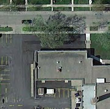


10 UPDATE EXISTING Existing Conditions: Hiawatha School 116

11 44TH AVE S CH 4 NEIGHBORHOOD PARK PLANS HIAWATHA SCHOOL NOTE: School-owned Property ND AVE S Proposed Plan: Hiawatha School
12 THE PROPOSED DESIGN In early designs, MPRB planners showed two options for the park: one that showed planning ONLY on MPRB land and one that expanded planning throughout the park as a whole. However, through various stages of community engagement and various iterations of the design, the proposed design makes no changes to the school portion of the property. That half of the park is shown in the plan for reference, but all facilities large accessible play area, basketball court, and open eld area are as existing. The only change here would be the eventual removal of the degraded horseshoe pits in favor of more open eld space. Near the recreation center, the wading pool is relocated in order to create a more open, year-round entry pla a and gathering space for the building. A new wading pool replaces the tennis courts in the northeastern part of the park. A second play container between the existing play area and the new pool provides additional play opportunity and diversity. The parking lot is reconstructed in its current location. An urban agriculture area sits between the parking lot and the building entry, and will create an extension of the entry experience for the building. This area could be implemented in cooperation with the school, to provide students the opportunity to learn about agriculture and gardening. Two multi-use diamonds are removed in favor of creating more multi-use eld space for eld sports, ice skating, hockey, and general play, as during school recess. The two diamonds along 44th Avenue would be retained, thereby keeping the open play space nearer the school and removing the barriers of backstops from between school and park. Between school and park is a new outdoor classroom and gathering space. This greenspace between the two buildings is of particular interest to parents at Hiawatha School and park users, as it could provide opportunities for both outdoor instruction by school teachers and outdoor programming by recreation center sta. It could be the perfect shared space for both school and park, thereby embodying the collaboration between MPRB and MPS at this park. The integration between the school day and the park play day is seamless at Hiawatha School Park, and will be reinforced by breaking down physical barriers between the two and creating shared spaces throughout. KNOWN LAND USE AND COORDINATION ISSUES The property line between MPS and MPRB is shown on the park plan, but has been largely ignored for planning purposes. Many improvements shown in the park plan will require coordination with MPS. UPDATE EXISTING Wading Pool Traditional Play Structure Multi-use Field Multi-use Diamond Basketball Court Skating Rink Hockey Rink NEW/ ADDED Urban Agriculture Area OPERATIONS ESTIMATE Outdoor Gathering Space 118
13 PROCESSES aquatics play 2: Initial Concepts + Public 1: General Input Comment 3: The Preferred Concept Spring-Fall 2015 Fall-Winter-Summer 2015/2016 Now Mixed opinions one wading pool; desire for bigger, deeper pool Play area well liked (though this may apply to both the play area on school property and the one on park property) no comments Like new play area south of building, so big and small can play together Various ideas about arrangement of play areas and other amenities Wading pool relocated to area of existing tennis court (main reasoning is to move the pool from the front entry of the building) Traditional play area expanded in same general location near recreation building Older-age accessible play area retained on school property other landscap winter courts athletic Soccer field preferred more often than baseball Tennis court not often used, but is in poor condition Desire to keep open play area on school property Basketball should be kept away from play areas Various ideas about arrangement of play areas and other amenities Removal of two multi-use diamonds to create additional multi-use field space Basketball court retained on school property no comments Like having the ice rink in the park Skating area and hockey rink in same general location no comments Urgan agriculture is a good idea Include pollinator / native plants Like outdoor classroom Urban agriculture area designated just north of recreation building Addition of outdoor classroom and naturalized areas between school and park (would require coordination with Minneapolis Public Schools) no comments no comments no other facilities planned for this park CH 4 NEIGHBORHOOD PARK PLANS HIAWATHA SCHOOL 119
14 COST ESTIMATE Asset Type Project 2017 ESTIMATED COST/PROJECT Implementation Sequence Prioritization Category Applicable SSAMP Actions Aquatics Play Play Athletics Wading Pool, $ 887,072 PLANNED 11, 16 Traditional Play Structure in new containers $ 698,158 PLANNED 11, 16, 23b, 23d Replace Large Accessible Play Structure $ 872,698 CONDITIONAL 11, 16, 23b, 23d Athletic field renovation, $ 1,162,228 PLANNED 11, 16, 21a, 21b, 21d Courts Basketball court $ 106,777 CONDITIONAL 11, 16, 18, 22b, 22c Landscape Urban Agriculture Area $ - CONDITIONAL 11, 19, 22b Landscape Naturalized areas $ 4,435 PLANNED 11, 26, 29 Landscape Parking Lot Renovation $ 122,995 PLANNED 28 Landscape Building entry plaza $ 22,120 PLANNED Other Outdoor Classroon / Gathering Area $ 65,709 CONDITIONAL 11 Other Renovate walking paths $ 156,979 PLANNED 11, 17 Other Miscl. signs, trees, furniture $ 73,718 TOTAL $ 4,172,888 PLANNED 9,
15 This page was intentionally left blank
16 This page was intentionally left blank
17 KEEWAYDIN LOCATION AND HISTORY Keewaydin Park, like Hiawatha School Park, shares a city block with a public school. The block is bound by 52nd Street, 31st Avenue, 53rd Street, and 30th Avenue. The park sits on the eastern half, and the Lake Nokomis Community School s Keewaydin Campus sits on the western half. Keewaydin came into being as the result of votes by the school board and park board in 1927 to cooperate on the purchase and use of a new school and playground. The school would provide a gym and shelter while the park board would develop outdoor playground and recreation facilities. The 1928 annual report called this the rst instance of close cooperation between the two boards, although earlier e orts to develop Audubon and Stewart parks also involved collaboration between the two boards. The name comes from Henry Wadsworth Longfellow s The Song of Hiawatha. Keewaydin was the Northwest Wind, the Home Wind. The land to the east of the already built school was purchased through condemnation procedures. After the acquisition, Nokomis Avenue between the park and school was vacated. Improvements began immediately in 1928 and 1929, when 38,600 cubic yards of ll were used to create a level playing eld. By the summer of 1930, the park board provided recreation instructors for the new park after playground equipment was installed and two tennis courts with backstops were built. In 1930 and 1931 the park board continued to haul in ll in a ght to keep the land at a level grade. Because the park was built on a former swamp, the ll kept settling. Finally in 1932, the elds were regraded and the tennis courts and a concrete wading pool were nished. In 1959 year-round recreation programming began at the park. The park board redeveloped the park and built a recreation center there in At that time the park board and school board considered making the recreation center part of the school, but ultimately decided to build a free-standing facility. In the early 2010s, the school planned an expansion southward on the site. That would put the school s front entrance in close proximity to the existing wading pool and would require shrinking of the playground both facilities were on school property under agreement with MPS. MPRB created a new master plan for the park that relocated park facilities onto park land. Those improvements have not ye been completed. EXISTING CONDITIONS AND CHARACTER Keewaydin Park has a somewhat unusual layout, when property ownership is taken into consideration. The wading pool and playground, along with the shared parking lot, actually sit on MPS property. The recreation center building is half on MPRB land and half on MPS land. East of the school on MPRB property are four multi-use diamonds with open eld space between 123 them. This arrangement is typical of south Minneapolis parks, but at Keewaydin the diamonds are particularly tight because the park is so narrow. South of the diamonds and above a slight rise is another open eld. This used to be the location of tennis courts, which were previously removed. Though MPRB spent considerable e ort in the late 1920s lling the site for athletic elds, the park is still in a bowl below street level. On the east and north sides of the park in particular the land slopes steeply down into the park. The northern slope is somewhat heavily forested, with an understory of mostly volunteer grasses and other plants. Pathways ank the northern and western (school) side of the park. The park is used regularly by the school for recess, and many kids participate in after school programs at the recreation center building. The school has a direct entrance into the park on its eastern side, where lower level doors allow a connection without slopes. A paved vehicle access to the building near the recreation center doubles as an area for basketball and other court games. CONNECTIONS BETWEEN PARKS Way nding and connections from Keewaydin Park should focus on: The existing City of Minneapolis bicycle/ pedestrian route Nokomis Avenue, including an enhanced connection through the park, to connect to Minnehaha Parkway to the north and Bossen Field to the south. The southward connection is important as Bossen will have the nearest wading pool to Keewaydin. A proposed pedestrian and/or bicycle route running on 53rd Street west to Lake Nokomis. This connection is important for access to the 50th Street Beach. CH 4 NEIGHBORHOOD PARK PLANS KEEWAYDIN

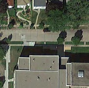


18 UPDATE EXISTING Existing Conditions: Keewaydin 124

19 E 52ND ST NOTE: School-owned Property Proposed Plan: Keewaydin NOTE: Wading pool to be removed from school property E 53RD ST AP 31ST AVE S CH 4 NEIGHBORHOOD PARK PLANS KEEWAYDIN 125
20 THE PROPOSED DESIGN The Keewaydin Park plan draws on but modi es through additional community engagement a 2011 master plan prepared when the school expanded. That master plan called for all MPRB facilities to be moved o school property and onto the green space east of the recreation building (the building itself would remain). In addition, the plan called for reduction of the multi-use diamonds from four to two, to allow for greater exibility in athletic use. The Keewaydin Park plan developed as part of SSAMP makes the same changes to the athletic elds, positioning the two remaining diamonds on opposite corners, instead of on one side, as in many parks, due to the small si e of Keewaydin. The slopes around the elds would be naturali ed with pollinator-friendly plants, and new and refurbished pathways create a walking loop (with city sidewalks) around most of the park. The entire grassy area east of the recreation building will become a play area with multiple options for multiple ages. All three play types will occur here: a smaller traditional play area in the center, a nature play area to the west under the trees, and an adventure play one to the east made up of a vertical climbing/bouldering wall. This would be the rst climbing facility in the MPRB system. It will be designed to be used either unsupervised or as part of MPRB programming. There will be no aquatic facility in this park. The existing wading pool and playground in front of the school will be removed and the land returned to MPS use. The addition of a varied and unique play environment will make Keewaydin a special park sure to draw users of all ages to try their hands at bouldering or experiment creatively with logs and stones. KNOWN LAND USE AND COORDINATION ISSUES Ongoing coordination with MPS is necessary, as some pathways and half the recreation center building sit on MPS property. MPRB should ensure the agreement with MPS is up to date prior to major capital improvements associated with play areas. UPDATE EXISTING AP Traditional Play Structure Multi-use Field Multi-use Diamond NEW/ ADDED Adventure Play Nature play area Walking Loop Trail 126
21 PROCESSES aquatics 1: General Input 2: Initial Concepts 3: The Preferred Concept Spring-Fall 2015 Fall-Winter 2015/2016 Now no comments Wading pool not necessary, due to proximity of Lake Nokomis and other parks No aquatic facilities planned for this park play no comments Many comments in support of climbing/bouldering wall Addition of multi-faceted play area east of recreation center, to include traditional play elements, a nature play area, and a climbing/bouldering wall athletics no comments Very few comments with clear stances Removal of two multi-use diamonds to create more multiuse field space (NOTE: this recommendation is included in the previous master plan for the park) other landscap winter courts no comments Concern about removing basketball court (NOTE: court is on school property) No court facilities planned for this park (basketball and court games area exist on school property) no comments no comments No formal winter facilities planned for this park no comments no comments Addition of naturalized areas on park slopes and near play area and recreation center no comments no comments Addition of paths to create walking loop around park CH 4 NEIGHBORHOOD PARK PLANS KEEWAYDIN 127
22 COST ESTIMATE Asset Type Project 2017 ESTIMATED COST/PROJECT Implementation Sequence Prioritization Category Applicable SSAMP Actions Play Area: Play $ 1,256,685 FUNDED 7, 11, 16, 18, 23a, 23b, 23d Play Nature Play area $ 349,079 PLANNED 11, 16, 23a, 23b, Athletics Athletic field renovation, $ 1,162,228 PLANNED 11, 16, 21a, 21b, 21d Landscape Naturalized areas $ 23,409 Other Renovate walking paths $ 106,843 Other Miscl. signs, trees, furniture $ 57,827 n/a Update agreement with MPS related to capital improvement $ - PLANNED 11, 25, 26, 29 PLANNED 11, 16, 17 PLANNED 9 PLANNED 11 TOTAL $ 2,956,070 OPERATIONS ESTIMATE 128
23 LONGFELLOW LOCATION AND HISTORY Avenue and 28th Street, was purchased for in In 1912 park superintendent Theodore Wirth wrote that despite the park s popularity and its accessibility by street car, it was sold in The Minneapolis Steel and Machinery Company, which was located east of the park, asked the park board in late 1917 to name its price for the land. Within a month the deal was done. The park board explained that it made the deal because the area was no longer suitable for a park because of the growth of manufacturing businesses in the area. As part of the resolution to sell the park, the board included playground nearby in south Minneapolis. Longfellow Field was completed, the board designated land for a second Longfellow Field, the three blocks from 35th to 38th Avenues South between East 34th and East 35th Streets. Appraisers were immediately appointed to determine the value of the new site for purchase by condemnation. In 1918 the board chose to defer purchase of the westerly block (the only one with houses on it in this thinly settled area of the city), and reached agreement with the single owner of the two blocks where the park now stands. wasn t paid for through property assessments. Because in 1917, the board bought the new land and paid for all improvements with those funds. The neighborhood around Longfellow Field is one of the only ones in the city that did not pay for its neighborhood park through property assessments. That changed in 1961 when the park board approved splitting the cost between bonds old wood shelter. By 1963 the whole park was rebuilt, with new playground equipment, new tennis courts, enlarged athletic areas, and a modern brick building. The modern brick building at Longfellow was one of the the showcase recreation building in the city before the building boom in recreation and community centers in parks in the 1970s. A new community center with a gym was begun in Several playground renovations were carried out in Longfellow, an American poet who wrote The Song of Hiawatha in The poem made Minnehaha Falls famous around the world, although Longfellow had never visited the falls. The current Longfellow Field was The 1918 annual report of the board includes park superintendent Theodore Wirth s initial plan for the back of a grandstand overlooking a combined football submitted a revised plan for a small wood-frame shelter in the park, which he admitted was not much more than a toilet building. In 1929, Wirth submitted another house. Instead he recommended a standard shelter to replace the wood building, which he called entirely inadequate. Although Wirth s plan was revised in 1930, after input from the neighborhood, to include croquet and basketball courts and eliminate the running track, neither of the plans were ever implemented. The Great Depression put an end to those plans and the temporary shelter built in 1921 was not replaced until the 1960s. The wood shelter at Longfellow was one of few improvements in neighborhood parks in that era that EXISTING CONDITIONS AND CHARACTER Longfellow Park s recreation center building is located in the southwestern corner of the park. A small parking lot takes access from 35th Street. The building sits high ground extends north and wraps to the east along in the park, which is made even nicer by a meandering pathway and mature trees. in a grassy area studded with picnic tables. North of this are play areas and a wading pool, all arranged like of the wading pool is a forested picnic area. In the northeast corner of the park are two tennis courts, a half-tennis bang-board, and two half-court basketball The park manages to be very active while also providing places of respite under the trees. Most of the large conifers and deciduous trees. The arrangement of the amenities in the park is elegant and provides easy connections between sports, play, and relaxation. CH 4 NEIGHBORHOOD PARK PLANS LONGFELLOW 129

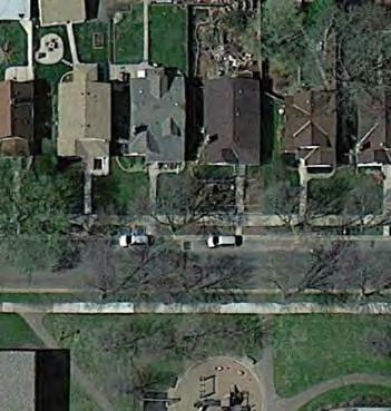


24 UPDATE EXISTING Existing Conditions: Longfellow 130

25 CH 4 NEIGHBORHOOD PARK PLANS LONGFELLOW 38TH AVE S E 35TH ST TH AVE S Proposed Plan: Longfellow
26 CONNECTIONS BETWEEN PARKS Way nding and connections from Longfellow Park should focus on: A partially existing partially planned City of Minneapolis bicycle/pedestrian route on 38th Avenue heading north, which connects north to Brackett Field. This connection is important for Brackett, as that park will no longer have tennis courts. The existing City of Minneapolis pedestrian/ bicycle route on 37th Avenue heading south, which connects to Adams Triangle and the bike route on Minnehaha Avenue to Minnehaha Park. The existing City of Minneapolis pedestrian/ bicycle route heading east on 35th Street to the Mississippi River Parkway. THE PROPOSED DESIGN The design for Longfellow Park strives to keep the general arrangement and elegance of the park while providing space for expanded and new facilities. The multi-use diamonds are reduced from four to two, as in many SSA parks, to allow for greater exibility in sports scheduling and greater diversity of use. Arranging the diamonds along the eastern edge of the park allows for a larger winter skating and hockey area in very close proximity to the building. New seating steps on the east side of the building take advantage of the slight slope downward to provide spectating space for winter and summer sports. The high ground on the western and northern edges of the park is preserved and is home to many of the same amenities. The building pla a is enhanced to create an indoor-outdoor space in concert with the community room. This could become an excellent venue for parties, graduations, concerts, and events. Two play areas and a wading pool sit in their same general locations, but stretch farther to the north, to allow more space for play features. An adult tness area is also shown in this vicinity, to allow parents to exercise while their children play. A picnic area remains under the trees at the northwestern corner of the park. The courts area is expanded and revised, with the addition of a 3rd tennis court (any of these could also be striped for pickleball and/or volleyball) and a fullsi e basketball court. A small seating pla a between these two court areas provides rest and waiting space. Because this park s basketball use seems to be mainly among younger ages, the hoops here could be adjustable to allow for more of a shoot-around game, as well as the full-court game. Additional pathways will allow for walking loops around the park. Areas between facilities on the northern and western edges of the park will be naturali ed with pollinator-friendly plants. Longfellow Park will feel much as it does today, with active uses throughout and small corners of respite and relaxation tucked under the lush tree canopy. New facilities, however, will make the park even more fun. KNOWN LAND USE AND COORDINATION ISSUES No known land use issues exist with Longfellow Park. UPDATE EXISTING Wading Pool Traditional Play Structure Outdoor Gathering Space Basketball Court Tennis Court Multi-use Field Multi-use Diamond Skating Rink Hockey Rink NEW/ ADDED Adult Fitness Walking Loop Trail Tennis Court 132
27 PROCESSES aquatic Wading pool needs to be bigger and deeper no comments Wading pool with shade structure in generally the same location play Playground very well liked (but needs new equipment). Could be expanded. Concern that the play area seems smaller than it is today Traditional play areas reconstructed in vicinity of wading pool, but the same size athletics Multi-use fields tend to be more important than diamonds Add premier field for soccer Removal of two multi-use diamonds to create larger multiuse field space. Hillside seating provided near multi-use field courts winter Tennis courts heavily used here Full court basketball is needed, but hoops are heavily used Ice rink is heavily used Much concern about location of basketball court near building; prefer open access. Concern basketball court is taking space from the play areas Consider multi-use on one or more tennis courts (for pickleball) Integrate ice rink into landscape better, maybe with stepped seating Addition of one tennis court to existing tennis area. Multiuse striping on one or more courts Replacement of half-court basketball with one full-court on northern edge of park Ice rinks installed over multi-use field, as existing. Larger area of multi-use fields allows greater flexibility and size of ice sheet. Hillside seating provided CH 4 NEIGHBORHOOD PARK PLANS LONGFELLOW 133
28 PROCESSES CONT. landscape other More natural areas desired Requests for urban agriculture in this park Maintain good tree cover/shade Add native plants and landscaping; fewer mown areas Addition of naturalized areas along western edge of park Tree canopy preserved and enhanced throughout western section of park Urban agriculture area not provided in this park (a principal site is nearby at Adams Triangle) Walking paths in the park well-liked Like adult fitness near kids' play area Adult fitness provided near play area Grills and picnic area is heavily used Consdier lawn games, like bocce or bean bag toss Improved gathering space between building and play areas; better connection between bulding and outdoors OPERATIONS ESTIMATE 134
29 COST ESTIMATE Asset Type Project 2017 ESTIMATED COST/PROJECT Implementation Sequence Prioritization Category Applicable SSAMP Actions Aquatics Wading Pool, $ 763,867 PLANNED 16 Play Traditional Play Structures (2) in new container $ 698,158 FUNDED 16, 23b, 23d Athletics Athletic field renovation, $ 1,396,316 PLANNED 16, 21a, 21b, 21d Courts Tennis Court (3) $ 320,331 PLANNED 16, 18, 22c Courts Basketball Court $ 106,777 PLANNED 16, 22a Landscape Naturalized areas $ 45,175 PLANNED 26, 29 Landscape Parking Lot Renovation $ 147,572 PLANNED 28 Other Gathering Space/Plazas $ 381,112 PLANNED 16 Other Adult Fitness $ 66,839 PLANNED 16, 18 Other Renovate walking paths $ 451,618 Other Miscl. signs, trees, furniture $ 86,422 TOTAL $ 4,464,188 PLANNED 16, 17 PLANNED 9, 17 CH 4 NEIGHBORHOOD PARK PLANS LONGFELLOW 135
30 This page was intentionally left blank
31 MATTHEWS In LOCATION AND HISTORY Matthews Park, along with the public Seward Montessori School, sits on an L-shaped piece of land generally bounded by 24th Street, 29th Avenue, 25th Street, and 27th Avenue. It sits in the center of the Seward Neighborhood. The early history of Matthews Park is connected to that of Longfellow Park. When recreation director Cli ord Booth noted in 1910 that he wanted to build a playground in the southern section of the city between Powderhorn and Riverside playgrounds, the result was Longfellow Field, located at Minnehaha Avenue and East 28th Street. This popular park, however, was sold in 1917 to a manufacturing company, and land for a new Longfellow Field, the one that still exists today, was purchased a little over a mile to the south and east. Thereby area of the city that Booth thought most needed a new playground no longer had one. The neighborhood would wait nearly fty years to get another. The campaign for another playground in the Seward neighborhood began in January 1958 when the PTA at Seward School requested a hearing by the park board on creating a playground to serve the school s area. The park board requested bond funds for Seward Park in its 1959 and directed park sta to make a joint study of the area with the school board. Despite more petitions from the neighborhood in the next two years, bonds for the new park were not forthcoming. But in 1961, even in the absence of bond funding, the park board designated two city blocks for acquisition. In August and September of 1961 the rst seven lots for the park were purchased. Over the next two years several additional lots were purchased for the park using an unanticipated source of funds: money paid to the park board by the state department of transportation for park land it had taken for constructing freeways through the city. By the end of 1963 the park board had acquired a little less than three acres of land, one lot at a time. Houses existed on most lots the park board removed the houses on its new land, lled the basements, graded the land to prepare for a skating rink that winter, and erected a portable warming house. While small acquisitions for the park continued over the next couple years, the bulk of the land to round out the park was acquired in 1967 with federal funds through the Department of Housing and Urban Development s Open Space program. The development of Matthews Park followed a new model of combining a park, school, and social agency at one location. In 1966, the park board adopted a formal policy for its role in those partnerships, which was in uenced by the new superintendent of parks, Robert Ruhe, who believed that recreation and leisure pursuits should be an integral part of neighborhood life. The social agency that partnered with the park board and school board at Matthews Park was Pillsbury Waite Neighborhood Services. In 1969 construction was completed on a recreation center attached to what is now Seward Montessori School. Also completed that year were a volleyball court, basketball court, tennis courts, playing elds and a wading pool. The park also included a unique feature in an otherwise at section of the city, a man-made hill in the southwest corner of the park that separated the park from businesses to the southwest. The hill is very popular for winter sledding. The park was named for Charles E. Matthews in Matthews was a neighborhood resident who had been active in the community, in particular campaigning for the park. Until the park was o cially named it was referred to as Seward Park after the elementary school adjacent to the park and the neighborhood in which it is located. The school was named for William Seward, a former United States Senator from New York, who became secretary of state in Abraham Lincoln s cabinet. The recreation center was renovated in 1993 and additional improvements to the playgrounds and playing elds were made over the next two years. In 2010 the playground was upgraded to improve accessibility. EXISTING CONDITIONS AND CHARACTER Though a property line between the school and park runs through the center of the wading pool and playgrounds as an extension of 24th Street, it is important to think of the site as a single park. The recreation center sits on the far northern edge, attached to the school building. A courtyard/pla a with trees and degraded turfgrass stretches south to where the wading pool and two play areas sit. The main square of the park is immediately south of the pool and a pathway connecting 24th Street. The eastern half of the main square is home to two multi-use diamonds with eld space in between. This area is also popular for winter skating. The western half is more wooded, and features another small play area, several meandering paths, two tennis courts, a sand volleyball court, and a full-court and two half-court basketball courts. The southwestern corner of the park is home to the large sledding hill, which also serves as a pleasant landform on which to relax in other seasons. The park is active at all times, mainly because of the connection to the school. The Seward Neighborhood in general and the school speci cally are home to many people of color, predominantly of East African descent. All the courts and elds are often used simultaneously, with the sledding hill run-out area often used for pickup soccer and other games. CONNECTIONS BETWEEN PARKS Way nding and connections from Matthews Park should focus on: The proposed bicycle/pedestrian connection along 24th Street to the east and west. Though it would pass directly through the neck of the park, a calmed pathway would be appropriate here. To the east, this route connects to the Mississippi River. To the west it crosses Hiawatha Avenue on a pedestrian bridge and then connects to East Phillips Park and Phillips Community Center The existing City of Minneapolis bicycle/ pedestrian route on 29th Avenue, which connects south to the Midtown Greenway and north to Riverside Avenue and the Mississippi River. CH 4 NEIGHBORHOOD PARK PLANS MATTHEWS 137

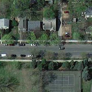


32 UPDATE EXISTING Existing Conditions: Matthews 138

33 36TH AVE S E 35TH ST NOTE: School-owned Property NOTE: Calmed bicycle route through park MC Proposed Plan: Matthews E 25TH ST 29TH AVE S CH 4 NEIGHBORHOOD PARK PLANS MATTHEWS 139

34 THE PROPOSED DESIGN Matthews Park is not signi cantly changed, but several modi cations reinforce recent and current projects and improve year-round use. The wading pool and two nearby play areas are reconstructed in their same locations. Just to the south of these amenities, a wider, calmed bicycle and pedestrian pathway allows nonmotori ed tra c on 24th Street to cross the park and continue on. In the athletics area, just one of the two multi-use diamonds remains the southerly one in order to allow more space for open eld games and eld sports, as well as winter recreation. The vibrant skating program at Matthews is enhanced by the addition of a permanent warming house / picnic shelter on the edge of the elds. This new type of building would serve as a warming house in winter, then its removable walls would be taken down so it can be an open-air picnic shelter in the summer. The basketball courts, volleyball courts, and small play area are as they are today, while the tennis courts would become multi-use courts, focused on tennis and pickleball. A new small nature play area nestles into the forest near the southern edge of the park. Some new paths allow for walking loops throughout the park, while some slopes of the hillside and most of the southern edge of the park is naturali ed with pollinator-friendly plants. Matthews Park works pretty well as it is today, so the proposed design makes some limited additions and enhancements, but leaves it mainly unchanged. The wooded character of the park, now reaching full maturity, is preserved throughout. The park will continue to welcome neighborhood residents and school children for a wide variety of activities in all seasons. KNOWN LAND USE AND COORDINATION ITEMS As portions of the park are owned by MPS and jointly operated by MPRB, ongoing coordination in any implementation projects will be necessary. This is mainly true of any improvements to the wading pool, two of the playgrounds, and the recreation center building itself, all of which sit entirely or partially on school property. UPDATE EXISTING Wading Pool Traditional Play Structure Basketball Court Multi-use Field Multi-use Diamond Skating Rink Hockey Rink Broomball Rink Designated Sledding Hill NEW/ ADDED MC Multi-sport Court Walking Loop Trail Warming House Group Shelter 140 Nature play area
35 PROCESSES 1: General Input 2: Initial Concepts 3: The Preferred Concept Spring-Fall 2015 Fall-Winter 2015/2016 Now aquatics Wading pool needs improvement: bigger and deeper no comments Wading pool in same general location winter courts athletics play Play areas need improvement; improve equipment, drainage, maintenance, etc. Mixed opinions on multi-use diamonds Tennis courts heavily used Basketball courts heavily used no comments Like addition of nature play no comments Support keeping tennis here; mixed opinions on multi-sport striping Consider basketball for kids Keep ice skating and hockey here Like permanent warming house / picnic shelter Encourage use of ad hoc ski loop around ball fields Three traditional play areas in same general locations Addition of nature play area in south of park Removal of one multi-use diamond to create additional multi-use field space Basketball courts in same general arrangement and location (one full-court, two half-courts) Multi-use courts (tennis, pickleball, volleyball) in same general location as existing tennis courts Sand volleyball court in same general location Broomball, hockey, and skating rinks in northern end of multi-use fields Sledding hill in current location Addition of permanent warming house able to convert to picnic shelter in summer CH 4 NEIGHBORHOOD PARK PLANS MATTHEWS 141
36 PROCESSES CONT. 1: General Input 2: Initial Concepts 3: The Preferred Concept Spring-Fall 2015 Fall-Winter 2015/2016 Now other landscape Open space is important in park Consider additional natural plantings and rain gardens Introduce areas for growing local food Desire for more and improvement of existing walking/biking paths, including bike way crossing park to link 24th Street More picnic areas, include pavilion Include native plants for insects, pollinators, and birds Provide safe connection through park at 24th Street Support for the picnic pavilion within the park, not on top of the hill Addition of naturalized areas mainly in southern portion of park Additional trails to create walking loops around park, including safe led/bike route across the park to connect 24th Street OPERATIONS ESTIMATE 142
37 COST ESTIMATE Asset Type Project 2017 ESTIMATED COST/PROJECT Implementation Sequence Prioritization Category Applicable SSAMP Actions Aquatics Renovate Wading Pool $ 739,226 FUNDED 11, 16 Play Traditional Play Structures (2) near wading pool $ 698,158 FUNDED 11, 16, 23b, 23d Play Traditional Play Structure near courts $ 349,079 PLANNED 16, 23b, 23d Play Nature Play $ 349,079 PLANNED 16, 23a, 23b, 23d Athletics Athletic field renovation, $ 776,188 PLANNED 11, 16, 21a, 21b, 21d Courts Basketball Court $ 238,195 PLANNED 16, 22a Courts Multi-sport Court $ 106,777 PLANNED 16, 22c Courts Volleyball Court $ 57,495 PLANNED 16 Landscape Naturalized areas $ 73,923 PLANNED 25, 26, 29 Other Picnic Shelter/Warming House $ 108,420 PLANNED 16, 18, 24 Other Renovate walking paths $ 470,910 Other Miscl. signs, trees, furniture $ 92,115 TOTAL $ 4,059,565 PLANNED 16, 17 PLANNED 9, 17 CH 4 NEIGHBORHOOD PARK PLANS MATTHEWS 143
38 This page was intentionally left blank
PARK PLANS SECTION CONTENTS: INTRODUCTION KEY/LEGEND PARK PLANS & COST ESTIMATES
 PARK PLANS SECTION CONTENTS: INTRODUCTION KEY/LEGEND PARK PLANS & COST ESTIMATES This page was intentionally left blank PROCESSES INTRODUCTION The South Service Area Master Plan creates unique new designs
and plant some trees, but that was only accomplished through state and federal work-relief programs.
 PEAVEY LOCATION AND HISTORY Peavey Park sits in the Phillips Community on a large block bounded by major streets: Franklin Avenue, Chicago Avenue, and Park Avenue. The southern continue through to Chicago
PARK PLANS SECTION CONTENTS: INTRODUCTION KEY/LEGEND PARK PLANS & COST ESTIMATES
 PARK PLANS SECTION CONTENTS: INTRODUCTION KEY/LEGEND PARK PLANS & COST ESTIMATES This page was intentionally left blank PROCESSES INTRODUCTION The South Service Area Master Plan creates unique new designs
NORTH OF BROADWAY SECTION CONTENTS: COTTAGE PARK FARVIEW PARK GLEN GALE PARK IRVING TRIANGLE JORDAN PARK NEWTON PARK PERKINS HILL PARK
 NORTH OF BROADWAY SECTION CONTENTS: COTTAGE PARK FARVIEW PARK GLEN GALE PARK IRVING TRIANGLE JORDAN PARK NEWTON PARK PERKINS HILL PARK N ILIO NA VE N JAM ES AV E PLAYGROUND PAR K PRO PER TY B OUN DAR Y
WEST CENTRAL SECTION CONTENTS: FARWELL PARK NORTH COMMONS PARK OLIVER TRIANGLE RUSSELL PARK THEODORE WIRTH REGIONAL PARK VALLEY VIEW PARK WILLARD PARK
 WEST CENTRAL SECTION CONTENTS: FARWELL PARK NORTH COMMONS PARK OLIVER TRIANGLE RUSSELL PARK THEODORE WIRTH REGIONAL PARK VALLEY VIEW PARK WILLARD PARK FARWELL PLACE THOMAS AVE N SWING BENCH PICNIC AREA
BASSETTS CREEK SECTION CONTENTS: BASSETTS CREEK BRYN MAWR LUCE LINE
 BASSETTS CREEK SECTION CONTENTS: BASSETTS CREEK BRYN MAWR LUCE LINE GLENWOOD AVE MULTI-USE DIAMONDS VINCENT AVE N MORGAN AVE N PENN AVE N DOG PARK MULTI-USE FIELDS PLAYGROUND AK E RD S CHESTNUT AVE DA
CLEVELAND PARK LOCATION AND HISTORY EXISTING CONDITIONS AND CHARACTER LOCATION
 CLEVELAND PARK LOCATION LOCATION AND HISTORY Attempts to create a neighborhood park and playground in the Cleveland neighborhood began in 1926, when the park board designated for acquisition the block
NORTHWEST SECTION CONTENTS: CLEVELAND PARK FOLWELL PARK RYAN LAKE PARK VICTORY PRAIRIE DOG PARK VICTORY PARK
 NORTHWEST SECTION CONTENTS: CLEVELAND PARK FOLWELL PARK RYAN LAKE PARK VICTORY PRAIRIE DOG PARK VICTORY PARK LUCY LANEY COMMUNITY SCHOOL N 33RD AVE N 33RD AVE SINGLE-FAMILY RESIDENTIAL MULTI-USE DIAMOND
FOLWELL PARK LOCATION AND HISTORY LOCATION
 FOLWELL PARK LOCATION LOCATION AND HISTORY Folwell Park is a large (by neighborhood park standards) tract of land located south of Dowling Avenue between Humboldt and Knox Avenues. The land for the park
EXISTING CONDITIONS AND CHARACTER
 DEMING HEIGHTS PARK LOCATION AND HISTORY Located in the Audubon Park neighborhood, Deming Heights Park is surrounded by a residential area. The first land for the park was acquired in 1913 along with the
HALL PARK LOCATION AND HISTORY EXISTING CONDITIONS AND CHARACTER LOCATION
 HALL PARK LOCATION LOCATION AND HISTORY Hall park straddles Lyndale Avenue on the city s near north side. This neighborhood was identified in a 1938 study of the city s playground needs as one of five
PIONEER PARK. City of Des Peres Parks Master Plan. SWT Design 46 INTRODUCTION
 PIONEER PARK INTRODUCTION Pioneer Park is a 7 acre neighborhood park located east of Interstate 270 and south of Manchester Road along Tallie Road. The park is situated in a residential neighborhood with
SHINGLE CREEK SECTION CONTENTS: BOHANON PARK CREEKVIEW PARK SHINGLE CREEK PARK SHINGLE CREEK REGIONAL TRAIL WEBBER PARK
 SHINGLE CREEK SECTION CONTENTS: BOHANON PARK CREEKVIEW PARK SHINGLE CREEK PARK SHINGLE CREEK REGIONAL TRAIL WEBBER PARK SPLASH PAD Good condition. PARK BUILDING BRYANT AVE N Good condition and unique to
2. Goals and Policies. The following are the adopted Parks and Trails Goals for Stillwater Township:
 D. PARKS AND TRAILS 1. Introduction Stillwater Township s population is relatively low, with most residents living on rural residences on large lots. The need for active park space has been minimal in
Chapter 6. Action Program. Heart of the Lakes Area Recreation Plan
 Heart of the Lakes Area Recreation Plan 1. Design and construct the following trails (please see the following map): a. the Speedway Trail 1) primary pathway the main trail 2) secondary pathway the proposed
M E S T I Z O C U R T I S P A R K
 ARAPAHOE CONNECTION TO BUS ROUTE AT ND AND LAWRENCE, FUTURE LIGHT RAIL STATION LEGEND SOCIAL TRAIL FLAGSTONE PAVING TO RESTORE/MAINTAIN CONCRETE PAVING DIAGONAL CURVILINEAR SOCIAL ROUTE IS OUT OF HISTORIC
Community Advisory Committee Meeting #3 April 21, 2015
 Community Advisory Committee Meeting #3 April 21, 2015 Purpose (charge) of the CAC: Be Knowledgeable, Be an Engaged Representative, Develop Master Plan, & Prioritize Plan 1 Welcome/ Introductions Review
Webber Park Master Plan Charrette Summary
 SMALL GROUP #1 - September 29, 2011 Webber Park Master Plan Charrette Summary More trash cans, especially near picnic grounds A year round pool is very needed-physical & mental health are significantly
APPENDIX E: SUMMARY OF PUBLIC MEETING QUESTIONNAIRE RESULTS
 Appendices Gwinnett County 2004 Comprehensive Parks and Recreation Master Plan APPENDIX E: SUMMARY OF PUBLIC MEETING QUESTIONNAIRE RESULTS March 2004 Monteith Brown Planning Consultants & The Jaeger Company
4MRV Parks Master Plan: Site Analysis
 4MRV Parks Master Plan: Site Analysis Lardner/Klein Landscape Architects in association with: RK&K Grimm + Parker Kittelson & Associates Partners for Economic Solutions RIB U.S.Cost Civil Engineering Architecture
Northeast Quadrant Distinctive Features
 NORTHEAST QUADRANT Northeast Quadrant Distinctive Features LAND USE The Northeast Quadrant includes all the area within the planning area that is east of Interstate 5 and to the north of State Route 44.
Nelson/Tasman Recreation Cross Boundary Partnerships. Presented by Richard Kempthorne Mayor Tasman District
 Nelson/Tasman Recreation Cross Boundary Partnerships Presented by Richard Kempthorne Mayor Tasman District Presentation in two parts Regional Communities Facilities Plan Regional Communities Facilities
Rating: 5.0 (scale of 1-10)
") 95 Community Trail System Groundcover: 2-metre paved path, 1- metre grass buffer on either side. Location: Fort St. John Ownership: City of Fort St. John Rating: 5.0 (scale of 1-10) Strategic value: Linear
95 Community Trail System Groundcover: 2-metre paved path, 1- metre grass buffer on either side. Location: Fort St. John Ownership: City of Fort St. John Rating: 5.0 (scale of 1-10) Strategic value: Linear
Trail Etiquette. Hours of Operation. Trail Accessibility
 Trail Guide The Elmhurst Park District, with 28 parks and over 460 acres of land, offers nearly six miles of paved or asphalt park trails and maintains an additional 3.6 miles of trails within Elmhurst.
Capital Prioritization
 14 Capital Prioritization 279 279 280 Park & Recreation CAPITAL PRIORITIZATION As described in Chapter 8, the recommendations presented in Chapter 9 are prioritized to provide a guide for future capital
Design Charrette Public Meeting
 Design Charrette Public Meeting Citizen Advisory Committee Members of the Public November 2, 2011 - Theodore Wirth Chalet - 6:30-8:30 p.m. Park Background: Visitation Estimation 2010 Regional Visitation
Wilds. Headwaters. Lakes. Oxbows. Falls
 56 5 4 3 Wilds Headwaters Lakes Oxbows Falls 57 Zones It could be said the on-the-ground essence of this master plan appears within the next 6 pages of this report. As we learned in the preceding Cultural
Chapter eight. Parks and Recreation. Introduction. Crystal Lake Park District
 Chapter eight Parks and Recreation Introduction One of the indicators of quality of life in a city is the parks and recreation system. The City of Crystal Lake is fortunate to have an excellent parks and
Schachtner Street. Village Park Somerset, Wisconsin
 Schachtner Street Village Park Village Park Schachtner Street Softball Field Lower Terrace Parking Area Baseball Field Upper Terrace Parking Lot Mid Terrace Parking Area Restroom Building Path to Bridge
New Haven-Adams Twp Parks & Recreation Dept Citizen Survey
 New Haven-Adams Twp Parks & Recreation Dept Citizen Survey Monday, October 02, 2017 281 Total Responses Date Created: Thursday, July 13, 2017 Complete Responses: 243 Q1: Do you live in New Haven-Adams
Winnebago County Community Park
 Directions to Community Park From Interstate Hwy. 41 to Oshkosh exit 124, which is Hwy. 76/Jackson Street. East on Hwy 76/ Jackson Street to left on County Road Y, 1/4 mile. Winnebago County Park is on
Welcome to the future of Terwillegar Park a Unique Natural Park
 Welcome to the future of Terwillegar Park a Unique Natural Park 1 Introduction The Terwillegar Park Concept Plan study will develop an overall concept plan, management objectives and development guidelines
35 Bee Tree Park Planning Zone 3
 35 Bee Tree Park Planning Zone 3 2701 Finestown Road Visit Date: August 2016 St. Louis County Parks Master Plan Page 1 35 Bee Tree Park 2701 Finestown Road St. Louis County Parks Master Plan Planning Zone
Welcome! INTRODUCTION. Tell us what you think! Comment forms are provided for your feedback
 Welcome! Comment forms are provided for your feedback Tell us what you think! INTRODUCTION The City of Salmon Arm s O cial Community Plan (OCP) and its Parks and Recrea on Master Plan (2012) both iden
Criteria Based System for MPRB Regional Park and Trail Capital Project Scheduling
 Criteria Based System for MPRB Regional Park and Trail Capital Project Scheduling July 19, 2017 Background Beginning with the 2017-2022 Capital Improvement Program (CIP), MPRB used equity-driven metrics
17 Mathilda Welmering Park Planning Zone 3
 17 Mathilda Welmering Park Planning Zone 3 8301 Mathilda Visit Date: September 2016 St. Louis County Parks Master Plan Page 1 Description: The six acre Mathilda Welmering Park is named for two streets
Dunsmuir Community Park
 Dunsmuir Community Park Master Plan September 2016 ENGAGEMENT SUMMARY #2 Introduction Public engagement is integral to the development of the Dunsmuir Community Park Master Plan. Two park open houses were
RENTAL DIRECTORY. Homewood-Flossmoor Park District HFPARKS.COM
 RENTAL DIRECTORY Homewood-Flossmoor Park District WELCOME The Homewood-Flossmoor Park District has a variety of facilities to help you plan the perfect location for your meeting or party needs, whether
Crookston Parks & Recreation Survey (Night To Unite 2016)
") Crookston Parks & Recreation Survey (Night To Unite 2016) Overview There were 95 surveys that were filled out at this year s Night To Unite Event in Central Park on Tuesday, August 2nd. People that filled
Crookston Parks & Recreation Survey (Night To Unite 2016) Overview There were 95 surveys that were filled out at this year s Night To Unite Event in Central Park on Tuesday, August 2nd. People that filled
RUSSELL PARK LOCATION AND HISTORY EXISTING CONDITIONS AND CHARACTER LOCATION
 RUSSELL PARK LOCATION LOCATION AND HISTORY Russell Triangle sits surrounded by streets in a neighborhood bounded by Broadway Avenue, Golden Valley Road, and Theodore Wirth Parkway. The small triangle is
Southwest Quadrant Distinctive Features
 SOUTHWEST QUADRANT Southwest Quadrant Distinctive Features LAND USE The 31.17 square mile Southwest Quadrant includes all the area within the planning area west of I-5 and south of the Sacramento River.
2014 Parks and Trails General Obligation Bond: $42 million. $3 million County Trails $1 million City Playgrounds $38 million FMRP
 2014 Parks and Trails General Obligation Bond: $42 million $3 million County Trails $1 million City Playgrounds $38 million FMRP FMRP Location and Connections Major Timelines Completion of phase I the
Dunsmuir Community Park
 Dunsmuir Community Park Master Plan February 2016 ENGAGEMENT SUMMARY #1 Introduction Public engagement is integral to the development of the Dunsmuir Community Park Master Plan. Overall, the process will
NEW MEADOWS PARK PROPOSED MASTER PLAN
 NEW MEADOWS PARK PROPOSED MASTER PLAN A vision for your neighborhood park, the draft master plan is ready for your review. Tuesday September 12 th, 2017 5:30-7:00 PM Hellgate School District #4 middle
Hemisfair Civic Park. Vision and Program Plan
 Hemisfair Civic Park Vision and Program Plan OCTOBER 2013 Hemisfair Civic Park Vision and Program Plan Prepared under the direction of the Hemisfair Park Area Redevelopment Corporation. Planning assistance
NORTH HEMPSTEAD BEACH PARK MASTER PLAN
 NORTH HEMPSTEAD BEACH PARK MASTER PLAN COMMUNITY DESIGN CHARRETTE Supervisor Judi Bosworth Viviana L. Russell Peter J. Zuckerman Angelo P. Ferrara Anna M. Kaplan Lee R. Seeman Dina M. De Giorgio VISIONING
Public Park System. Township of Derry. Providing natural open space for the recreational use of our residents and guests.
 Township of Derry Public Park System Providing natural open space for the recreational use of our residents and guests. Directory of Recreational Amenities Hershey s Commitment to Recreation Famous candy
MPRB: Southwest LRT Community Advisory Committee Issues and Outcomes by Location Current to: 12 November 2010
 MPRB: Southwest LRT Community Advisory Committee Issues and Outcomes by Location Current to: 12 November 2010 This is a compilation of issues and outcomes identified by the CAC. It is a work in progress,
Arvidson, Adam R. Adam,
 Arvidson, Adam R. From: Andrew Hestness Sent: Wednesday, May 18, 2016 5:39 PM To: Arvidson, Adam R. Cc: Renee Spillum; Schroeder, Michael Subject: RE: Park Dedication Attachments: FranklinPlan - Bystrom
Summary of Small Group Discussion Notes
 THE CORPORATION OF THE CITY OF WINDSOR Parks and Facilities/ Windsor Essex Local Immigration Partnership Community Consultation: Parks for Today-Planning for Tomorrow Dec 9, 2014 Windsor Public Library
Park Design and Location Criteria
 Park Design and Location Criteria This section is presented in the interest of assisting park and recreation agencies in the development of a system of parks and recreation areas. A recreation system is
CITY OF FOUNTAIN INN PARKS
 CITY OF FOUNTAIN INN PARKS Country Chase Fitness Park The Country Chase Fitness Park is located in the Country Chase neighborhood at 136 Catterick Way. The park is also located adjacent to a section of
City of Sierra Madre STUDY AREA PROFILE
 City of Madre STUDY AREA PROFILE STUDY AREA ID #112 BASE MAP PARK METRICS WHERE ARE PARKS MOST NEEDED AMENITY QUANTITIES AND CONDITIONS PARK NEEDS FRAMEWORK PROJECT COST ESTIMATES PROJECT REPORTING FORM
Dover Park Master Plan. Community Design Event Tuesday, May 22, 5 7 pm
 Dover Park Master Plan Community Design Event Tuesday, May 22, 5 7 pm Agenda I. Introduction / Overview 20 minutes II. Small Group Design Activity 60 minutes III. Small Group Report Out IV. Conclusion
Parks and Recreation Master Plan
 Emerging Themes Parks and Recreation Master Plan City of Mount Dora, Florida September 17, 2018- Revised October 1, 2018 Agenda Welcome & duction Master Plan The Inventory & Existing Community Overview
- Welcome. - Project Next Steps. - Intros. - Public Comment Time. - Guiding Principles Revisited. - Balance in the Service Area
 ST ONY RK VAN p ' LEVf uxr PARK ER CAC Role The appointed CAC for the East of the River Park Master Plan shall: Become knowledgeable about the project and its scope and advise MPRB staff and consultants
Tahoe Donner Association Public Scoping Meeting DUDEK
 Tahoe Donner Association Public Scoping Meeting DUDEK Introduction Purpose of this Meeting: Solicit feedback and ideas from members, and staff as we begin the Association Master Plan. Association Master
AGENDA MEMORANDUM Community Services Department. CSAB Meeting Date: April 10, 2018
 AGENDA MEMORANDUM Community Services Department CSAB Meeting Date: April 10, 2018 To: Community Services Advisory Board From: Dana A. Souza, Director Date: April 4, 2018 Legislative Quasi-Judicial SUBJECT:
City of Galion Park Satisfaction Survey Results
 City of Galion Park Satisfaction Survey Results Dec. 5, 2016 Goal: To get feedback from the community on: 1. General satisfaction of city-owned parks 2. How to improve park facilities and recreation opportunities
PARKS & BEACHES PROJECTS
 #18 72ND STREET PARK, LIBRARY, #19 BLUEWAYS & AQUATIC CENTER $1.1 MILLION $60 MILLION New facility to include: Create Kayak Launches with All Wheels Skate Park Floating Docks and Seating at: Library/Media
TRUCKEE TAHOE AIRPORT DISTRICT BOARD OF DIRECTOR STAFF REPORT
 AGENDA ITEM: 11 TRUCKEE TAHOE AIRPORT DISTRICT BOARD OF DIRECTOR STAFF REPORT AGENDA TITLE: MEETING DATE: January 24, 2018 PREPARED BY: NTPUD Agency Partnership Opportunity, Multi-Use Trailhead Access
Appendix B - Undeveloped Parks and Existing Parks with Remaining Development Programming
 Appendix B - Undeveloped Parks and Existing Parks with Remaining Development Programming Table of Contents Appendix B - Undeveloped Parks and Existing Parks with Remaining Development Programming Table
7 CORNERS SPECIAL STUDY, TASK FORCE MEETING 11/13/2012 PARKS AND RECREATION EXISTING CONDITIONS: HANDOUT #1
 PARKS AND RECREATION EXISTING CONDITIONS: HANDOUT #1 PARKS AND RECREATION EXISTING CONDITIONS: HANDOUT #1 Fairfax County Park Authority Parks (within one mile of Seven Corners) Park Acres Park Facilities
MINNESOTA ARCHITECTURE - HISTORY INVENTORY FORM Property Location
 MINNESOTA ARCHITECTURE - HISTORY INVENTORY FORM ------ - Property Location -- ---- Property Name: Washington Park Address: 215 N 4th Street County: Blue Earth City/Twp: Mankato PIN: R01.09.07.461.001 Legal
2015 Budget Parks & Recreation Department
 Parks & Recreation Department February 2, 2015 Slide 1 COMMUNITY ENGAGEMENT Over 11,000 attended Caledon Day Over 700 celebrated one-year countdown to Pan Am Games Recognized almost 200 volunteers at the
Dungeness Recreation Area County Park Master Plan
 Dungeness Recreation Area County Park Public Outreach Meeting October 10, 2007 Project Overview USFWS Site Dungeness Recreation Area County Park Meeting Objectives: Re-Introduce project; provide status
TOWN OF CANANDAIGUA PARKS AND RECREATION MASTER PLAN PUBLIC OPINION QUESTIONNAIRE
 TOWN OF CANANDAIGUA PARKS AND RECREATION MASTER PLAN PUBLIC OPINION QUESTIONNAIRE The Town of Canandaigua is updating its Parks and Recreation Master Plan. As part of our effort to plan for your future
Public Outreach and Online Survey Summary Report
 Public Outreach and Online Survey Summary Report To: Washoe County Regional Parks and Open Space From: Eric Hasty, Planner Wood Rodgers, Inc. Date: June 12, 2018 Re: WC Regional Parks and Open Space Master
20 Grant s Trail. Planning Zone 3. Visit Date: September St. Louis County Parks Master Plan
 20 Grant s Trail Planning Zone 3 Visit Date: September 2016 Page 1 20 Grant s Trail Planning Zone 3 Visit Date: September 2016 Page 2 20 Grant s Trail Planning Zone 3 Visit Date: September 2016 Page 3
Schoolcraft Township is located in northeast Houghton County. A portion of the township borders Keweenaw County and Lake Superior.
 COMMUNITY DESCRIPTION Schoolcraft Township is located in northeast Houghton County. A portion of the township borders Keweenaw County and Lake Superior. The township is largely rural but has one main population
The Narrows Waterfront Park A Crown Jewel for Southern Brooklyn
 The Narrows Waterfront Park A Crown Jewel for Southern Brooklyn In New York, the unquestioned popularity of urban spaces such as Riverside Park, the High Line, Brooklyn Bridge Park and others has demonstrated
LAUREL TRIANGLE LOCATION AND HISTORY LOCATION
 LAUREL TRIANGLE LOCATION AND HISTORY Laurel Triangle is a small triangle in the Bryn Mawr neighborhood, bounded by Cedar Lake Road, Laurel Avenue, and Oliver Avenue. It is a special consideration park
Classifications, Inventory and Level of Service
 Classifications, Inventory and Level of Service Section 3 Kenmore Park, Recreation and Open Space Plan 1 P a g e Classifications and Inventory Park Classifications Kenmore classifies its parks based upon
Stittsville Parks Information Session
 Stittsville Parks Information Session Amberway Park, Blackstone Park, Bryanston Gate Park & William Bradley Park Thursday, February 8, 2018 Open House 6:30-8:45pm Presentation 7pm Goulbourn Recreation
2014 SPLOST Final Draft County-wide Parks System Rehabilitation
 Page 1 of 5 ADA Improvements (County Wide) Accessibility projects related to trails/walkways, door entrances, pool access, curb cuts, ramps, etc. Additionally, ADA Audit of facilities to identify and prioritize
J. Recreation Plan of Conservation and Development. The Town of Hebron. Section 2. Preservation of Unique Assets. 1 P a g e
 The Town of Hebron Section 2 2014 Plan of Conservation and Development Preservation of Unique Assets J. Recreation Open spaces, parks, sports fields, and recreational programs are considered essential
FY20 BUDGET PRESENTATION
 FY20 BUDGET PRESENTATION Mission Statement: To provide for diverse recreational opportunities and amenities that enhance the quality of life for our residents and visitors to the City of Frederick through
EAST CITY PARK. 900 East Third Street 7.04 Acres
 EAST CITY PARK 900 East Third Street 7.04 Acres Description: Moscow s oldest park is great for leisurely summer strolls. Mature trees offer shade and relaxation, and a variety of activities exist in which
Section 4(f)/6(f) Determination Technical Report for Park and Recreational Lands
/6(f) Determination Technical Report for Park and Recreational Lands") Section 4(f)/6(f) Determination Technical Report for Park and Recreational Lands 1.0 Introduction 1.1 Purpose of Report This Section 4(f)/6(f) Determination Technical Report for Park and Recreational Lands
Section 4(f)/6(f) Determination Technical Report for Park and Recreational Lands 1.0 Introduction 1.1 Purpose of Report This Section 4(f)/6(f) Determination Technical Report for Park and Recreational Lands
DUNBAR & ASSOCIATES: ARNPRIOR RECREATION MASTER PLAN. Draft Community Workshop Meeting: June 26, 2014 Nick Smith Centre
 DUNBAR & ASSOCIATES: ARNPRIOR RECREATION MASTER PLAN Draft Community Workshop Meeting: June 26, 2014 Nick Smith Centre On Thursday, June 26, 2014 from 7:00 to 9:00 pm, Dunbar & Associates hosted a Community
China Creek North Park Upgrades and Glen Pump Station. Park Board Committee Meeting Monday, July 10, 2017
 China Creek North Park Upgrades and Glen Pump Station Park Board Committee Meeting Monday, July 10, 2017 Purpose The purpose of this presentation is to: Share the results of the public engagement processes;
7. Plan Implementation
 7. Plan Implementation 7.1 Implementation Timeline This section includes a list of achievable park and recreation actions. In the Implementation Action Matrix that follows, the implementation actions have
SOAR ATHLETIC COMMITTEE
 PASCAGOULA RECREATION COMMISSION MEETING MAY 15, 2017 Mike McElhaney opened the meeting at 6:00 pm. Mike welcomed Bo Cole as a guest. A special meeting was called to review the recommendation being made
Silver Lake Park An Environmental Jewel for the Citizens of Prince William County
 Silver Lake Park An Environmental Jewel for the Citizens of Prince William County The Prince William Park Authority Mission Statement states: The Prince William County Park Authority will create quality
6.5 DURANGO EXCELS AT PARK CONNECTIVITY
 City of Durango 6.5 DURANGO EXCELS AT PARK CONNECTIVITY The City of Durango excels at park connectivity as evidenced by the success of the Animas River Trail (ART) project. While it is clear there are
Frederickson LUAC. Community Plan Update. Parks & Recreation. September 25, 2017
 Frederickson LUAC Community Plan Update Parks & Recreation September 25, 2017 Kimberly Freeman Resource Stewardship Superintendent kimberly.freeman@co.pierce.wa.us 253-798-4261 Joseph Coppo Senior Parks
Community Input Meeting. Fairgrounds Master Planning Update. January 7, 2016, 7 pm
 Community Input Meeting Fairgrounds Master Planning Update January 7, 2016, 7 pm Fiesta Hall Santa Clara County Fairgrounds 355 Tully Road, San Jose, CA Tonight s Agenda 1) Board of Supervisors Direction
Washington Township MASTER PLAN. Addendum: Washington Township Master Plan
 Washington Township MASTER PLAN Addendum: Washington Township Master Plan CHAPTER XI RECREATION CORE DISTRICT Introduction The Recreation Core District generally encompasses the areas north of 30 Mile
Classes Other locations & Parks
 Other Parks 1 Classes Other locations & Parks Update: 6/11/2018 Visit us online at www.coconutcreek.net/parks-rec How to register for a class Registration is ongoing until filled, except in cases where
Acquisition in fee simple of approximately one-half acre of property on the shore of Spring Lake to expand the Lakeside Beach Park.
 Lakeside Beach TF00-136 $122,550.00 in fee simple of approximately one-half acre of property on the shore of Spring Lake to exp the Lakeside Beach. 2000 River Ravines TF00-150 $910,000.00 in fee simple
Lake Myra County Park. Wake County, North Carolina Community Forum #2 June 12, 2008
 Lake Myra County Park Wake County, North Carolina Community Forum #2 June 12, 2008 Welcome and Introduction Meeting Agenda Welcome Introductions of Project Team Master Plan Process Community Forum #1 Updates
CITY OF MANVEL Parks & Recreation Master Plan Community Meeting Summary
 CITY OF MANVEL Parks & Recreation Master Plan Community Meeting Summary The City of Manvel hosted a Community Meeting on June 23, 2016 at the Church of the Harvest. Over 25 community members attended and
Corktown Parks. Public Meeting. City of Toronto
 Corktown Parks Public Meeting City of Toronto 15-04-20 Agenda 1. Reasons for Study 2. Consultation to Date 3. Parks Evaluation 4. Community Context 5. Bright St. Playground 6. Orphans Green (Dog Off Leash)
WEST JORDAN PARKS, RECREATION AND TRAILS MASTER PLAN Advisory Committee Meeting #2
 WEST JORDAN PARKS, RECREATION AND TRAILS MASTER PLAN Advisory Committee Meeting #2 MONDAY, NOVEMBER 5, 2018, 6:00 P.M.; PARKS DEPT. CONFERENCE ROOM ATTENDEES: Lisa Dean Larry Gardner Duane Harding David
Concert Tent Anderson Building Entry
 Anderson Park Renovation Concept #1 Concert Tent Anderson Park Renovation Concept #2 Concert Tent Anderson Park Renovation Concept #3 Concert Tent Anderson Park Renovation Concept Tally Renovation Concept
City of Haslett. City of East Lansing. City of East Lansing
 Central Park North (Nancy L. Moore Park) Lake Park North Expansion White Park Expansion #2 White Park Expansion #1 County East East Haslett East East TF87-212 Acquisition $90,000.00 Park. TF08-138 Acquisition
AGENDA REGULAR PARKS COMMISSION MEETING May 26, :15 A.M Monticello Public Works Office
 Park Commission Agenda: 05/26/2016 AGENDA REGULAR PARKS COMMISSION MEETING May 26, 2016 9:15 A.M Monticello Public Works Office To enhance community pride through developing and maintaining city parks
The City of Durango Community Interest and Opinion Survey Executive Summary
 The City of Durango Community Interest and Opinion Survey Executive Summary Overview ETC Institute administered a community interest and opinion survey for the City of Durango between January and March
3. COLTA / HUGA CONNECTIONS - PRELIMINARY
 9 3. COLTA / HUGA CONNECTIONS - PRELIMINARY 3.1 COLTA The Chain of Lakes Trail Association (COLTA) trail, formerly identified as the Chester Spur Line, was completed and opened for use in June 2011. The
We offer a wide variety of facilities including meeting rooms, two gymnasiums, parks, pavilions, multi purpose fields baseball/softball fields,
 We offer a wide variety of facilities including meeting rooms, two gymnasiums, parks, pavilions, multi purpose fields baseball/softball fields, amphitheater, pool shelters, corrals and pools, making us