PARK PLANS SECTION CONTENTS: INTRODUCTION KEY/LEGEND PARK PLANS & COST ESTIMATES
|
|
|
- Rudolph Cook
- 5 years ago
- Views:
Transcription
1 PARK PLANS SECTION CONTENTS: INTRODUCTION KEY/LEGEND PARK PLANS & COST ESTIMATES
2 This page was intentionally left blank
. Those designs appear on the following pages, arranged alphabetically.")
3 PROCESSES INTRODUCTION The South Service Area Master Plan creates unique new designs for 27 of the 32 neighborhood park properties in the service area (the remaining 5 are special consideration parks as described on the following page). Those designs appear on the following pages, arranged alphabetically. The plan for each park is displayed as a 6 or 8 page packet of information that includes the following: A description of the history and current character of the park, along with a location map. An aerial photograph of existing conditions at the park, for reference A written description of the proposed plan for the park, including some overview of public sentiment during the planning process The park plan drawing and key A matrix showing general input themes and how they led to the nal design A cost and operations estimate (see chapter 6 for detailed information on cost estimates). The operations estimate re ects the di erence between the existing operational costs and the estimated operational cost. The neighborhood park plans are concepts. That means they do not nali e every detail in the park. Subsequent capital improvement projects will require detailed design processes, and additional community engagement will be performed at that time, per MPRB policy and ACTION 3. The park plans do not speci cally locate small features in the park, like benches and signs. Instead, they are a guide to the overall layout of the park and what will be included in the park in the future. NOKOMIS/HIAWATHA The parks surrounding the two recreation centers at Lakes Nokomis and Hiawatha are not included in the South Service Area Master Plan. Though they host neighborhood-type facilities, they are both o cially within the boundary of Nokomis-Hiawatha Regional Park, for which there is an approved master plan. That Regional Park Master Plan is the guiding document for these park areas. CH 4 NEIGHBORHOOD PARK PLANS INTRODUCTION 61


4 * SPECIAL CONSIDERATION PARKS Several park properties do not have full packets of information included in the SSAMP document at this time. The reasons for this vary by park and are described in abbreviated park packets appearing in alphabetical sequence with the other parks. Those park properties and the basic reasons for special consideration are: Bossen Field: recently master planned independently of the SSAMP. Cedar Avenue Field: insu cient community engagement prevented nal design. East Phillips: community decision to not master plan at this time Meridian Garden: managed by community group Rollins Triangle: tiny park triangle impacted by Minnehaha Avenue reconstruction PARKS INCLUDED 1. Adams Triangle 2. Bossen Field* 3. Brackett Field 4. Cedar Avenue Field* 5. Central Gym Park 6. Corcoran Park 7. Currie Park 8. Diamond Lake 9. East Phillips Park* 10. Hiawatha School Park 11. Keewaydin Park 12. Longfellow Park 13. Matthews Park 14. McRae Park 15. Meridian Garden* 16. Morris Park 17. Murphy Square 18. Normanna Triangle 19. Pearl Park Figure Park Location Key 20. Peavey Field Park 21. Phelps Field Park 22. Phillips Community Center 23. Powderhorn Park 24. Rollins Triangle* 25. Seven Oaks Oval 26. Shoreview Triangles (3 park properties) 27. Sibley Park 28. Solomon Park 29. Stewart Park 30. Todd Park * These parks are considered as a part of the overall service area master plan but are considered special consideration parks. 62

5 PROCESSES A PARK PLAN DOES DETERMINE The types and locations of facilities The general areas of mown and naturali ed landscapes and the general location of trees The extent and general location of pathways A PARK PLAN DOES NOT DETERMINE The speci c design of facilities The location of minor amenities such as benches, drinking fountains, and signs EXAMPLE: A park plan DOES determine: That there will be a traditional play area in a certain location in the park (as opposed to a nature play area in a di erent location) A park plan DOES NOT determine: The exact equipment, layout, color, surfacing Future capital projects will have their own community engagement processes at the time of implementation. CH 4 NEIGHBORHOOD PARK PLANS INTRODUCTION 63
6 For more detailed de nitions and pictures of plan elements, see Chapter 3. KEY/LEGEND AQUATICS Places to play in the water (swimming, splash pads) PLAY Places for youth to play (swings, slides, vertical climbings walls) ATHLETICS COURTS Sports on hard surface courts Wading Pool (small, shallow pool for children) Indoor Swimming Pool Beach Access Splash Pad (water play area with sprayers and fountains, with no standing water) Interactive Water Play (small stream/fountains for kids to play in) AP AP Traditional Play Structure (swings, slides, climbers) Adventure Play (place for challenging play for older youth and teens including climbing walls, zip line, obstacle course) Nature play area (play area for children that encourages creative play with natural materials) Multi-use Field (open turf that may be used for soccer or other sports) Multi-use Diamond for baseball or softball used for soccer or other sports) Premier Field (High other sports, often with permanent stripes Premier Diamond (High or softball, usually with a fence around the MC MC Tennis Court Basketball Court Volleyball Court Multi-sport Court (court striped to allow many pickleball, bike polo) SD SD Sports Dome (may be put up in winter to allow sports to be played year round) 64
7 WINTER USE Places to play in winter (ice skating, sledding) LANDSCAPE OTHER Other types of recreation in outdoor parks YR YR Designated Sledding Hill Skating Rink Broomball Rink Hockey Rink Year-round Rink (Hardsurface rink for hockey all year or bike polo in summer) Warming House Outdoor Gathering Space (Open area for community gathering/ picnics) Designated Urban Agriculture Area Mown Turf Grass Naturali ed Area (native vegetation areas, LG LG Group Shelter Stage / Bandshell (for outdoor plays, music, or classes) Adult Fitness (area with machines to work out in) Walking Loop Trail (walking path that loops around the park, includes signs and seating) Lawn/Court Games (small open lawn or court for games) Dog Park Disc Golf Archery (archery course) Skate Park Canoe/Kayak Launch Community Oven Restroom/Storage Building CH 4 NEIGHBORHOOD PARK PLANS KEY / LEGEND 65
8 This page was intentionally left blank
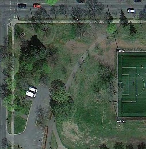
9 SEVEN OAKS OVAL LOCATION AND HISTORY Seven Oaks Oval is a deep depression in the ground just west of the Mississippi River at 34th Street. It is heavily wooded. The property was dedicated as a park in the plat of Seven Oaks River Lots in 1913, but the Board did not formally accept the property until 1922, after a formal inspection. The acquisition is not mentioned in the 1922 annual report, overshadowed as it was by acquisitions of neighborhood parks such as Sibley, Brackett and Pershing, the expansions of Victory Memorial and St. Anthony Parkways and Glenwood Park, and the possible purchases of Lake Hiawatha, and portions of Minnehaha Creek. Park superintendent Theodore Wirth proposed a plan in 1928 for the topographical oddity he called it a deep oval basin with ne trees. The plan called for lling the lowest parts of the basin to a suitable grade and constructing walks through it. Wirth also proposed that two sites in the park be prepared as camp re places (his map says council sites ) for the Boy Scouts and Camp Fire Girls. That part of the plan likely appealed to park commissioner Maude Armatage who was a leader of the Camp Fire Girls and served on the national organi ation s board of directors, but the plan was not implemented. In Wirth s comprehensive inventory of parks in his 1932 report, Seven Oaks Oval is lumped with 49 Other Small Triangles even though it is not a triangle and is more than 30 times larger than most of the other properties thrown into that category. Seven Oaks was likely included in that category because, like all but two others, it had cost nothing to acquire, and no money had been spent on its improvement. EXISTING CONDITIONS AND CHARACTER Because it is so close to the Mississippi River, Seven Oaks Oval is considered by some to be an important birding site. It has no formal amenities, though unauthori ed paths extend down into and through it. Sitting as it does o main roads, it is unlikely many know it exists. CONNECTIONS BETWEEN PARKS Way nding and connections from Seven Oaks Oval should focus on: Existing and proposed pedestrian and bicycle routes to the Mississippi River and Longfellow Park along 34th and 35th Street. CH 4 NEIGHBORHOOD PARK PLANS SEVEN OAKS OVAL 215
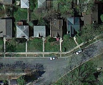


10 Existing Conditions: Seven Oaks Oval 216

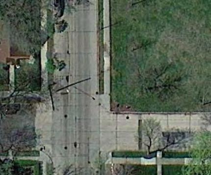
11 E 34TH ST UPDATE EXISTING Outdoor Gathering Space PARK TERRACE THE PROPOSED DESIGN The idea behind the plan for Seven Oaks Oval is to increase opportunities for nature appreciation, interaction, and study without compromising the natural resource itself. The single addition to the park, therefore, is a treehouse perched above the southwestern slope of the land. Because of the steeply descending hillside here, a level, ADA-accessible pathway/bridge from the street puts a visitor into the treetops relatively quickly. This creates a unique opportunity to provide an accessible canopy wildlife viewing experience unlike anything else in the system. Proposed Plan: Seven Oaks Oval 47TH AVE S Aside from the treehouse, the remainder of the site features habitat enhancement and restoration. KNOWN LAND USE AND COORDINATION ITEMS No known land use issues exist with Seven Oaks Oval. CH 4 NEIGHBORHOOD PARK PLANS SEVEN OAKS OVAL 217
12 PROCESSES 1: General Input 2: Initial /Preferred Concepts 3: The Preferred Concept Spring-Fall 2015 Fall-Winter 2015/2016 Now aquatics no comments no comments No aquatic facilities planned for this park play no comments Like idea of nature play No formal play areas planned for this park--park will be left as natural area (see also "Other Facilities) athletics no comments no comments No athletic facilities planned for this park courts no comments no comments No courts planned for this park winter no comments Sledding? No formal winter facilities planned for this park (safe sledding would be incompatible with retaining forested character) landscape no comments specific to Seven Oaks; many comments want more natural areas in parks Include interpretive information about ecology, geology, wildlife, vegetation Manage buckthorn and other invasives Site retained as natural area, with landscape management per established practices and policies other no comments Positive response to treehouse, suggestion to move entrance to north side of park, subsequent concern about impact on north and suggestion to move to southwest Addition of "treehouse" with access from southwestern side of park. Treehouse would be a fully accessible nature/wildlife viewing platform. 218
13 COST ESTIMATE Asset Type Element 2015 ESTIMATED COST/PROJECT 2017 ESTIMATED COST/PROJECT Implementation Sequence Prioritization Category Applicable SSAMP Actions Landscape Restore/Enhance forest ecosystem $ 67,050 $ 73,923 PLANNED 25, 26 Other Gathering Area/Tree House $ 466,519 $ 514,337 PLANNED 16 Other Miscl. signs, trees, furniture $ 10,000 $ 11,025 PLANNED 9 TOTAL $ 543,569 $ 599,285 OPERATIONS ESTIMATE CH 4 NEIGHBORHOOD PARK PLANS SEVEN OAKS OVAL 219
14 This page was intentionally left blank
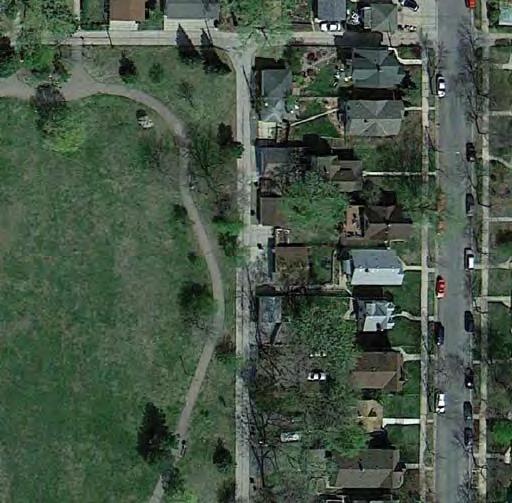
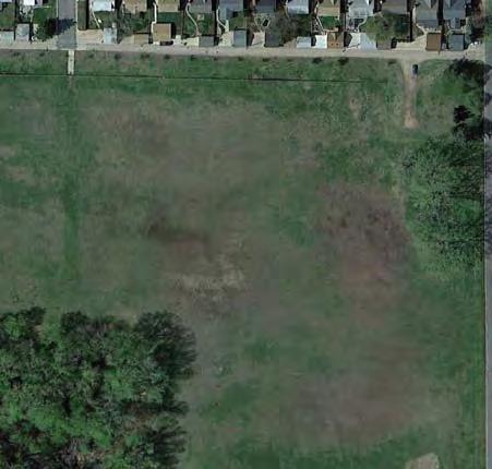
15 SHOREVIEW TRIANGLES LOCATION AND HISTORY The Shoreview Triangles are three parcels of unimproved land adjacent to Shoreview Avenue near the eastern side of Lake Nokomis. In the original plat of the neighborhood, these triangles are shown as park land (and it is likely they have always been considered as such), though MPRB did not actually acquire them until 2006, presumably from the City of Minneapolis. The southernmost and smallest triangle is located just south of 55th Street. It sits between Shoreview and 23rd Avenue. It is adjacent to single family homes to the south and does not have a road on its southern edge. The central triangle is at 54 ½ Street. That numbered street passes along the southern edge of the triangle but does not continue east past 24th Avenue nor west past Shoreview. The northernmost and by far the largest and most usable triangle is at 54th Street and Shoreview, with 25th Avenue passing along its eastern edge. EXISTING CONDITIONS AND CHARACTER All three triangles are mown turfgrass with some scattered trees. The 54th Street Triangle is regularly used by nearby residents for impromptu picnics and gatherings as well as ball and Frisbee throwing. Essentially, these are open spaces within a single family neighborhood of angled streets mixed in amongst the regular city grid. UPDATE EXISTING Multi-use Field THE PROPOSED DESIGN Early on in the SSAMP process, the design team proposed more robust improvements at the 54th Street Triangle, in response to community engagement showing a desire for more play in the area. However, the community later decided it wanted to keep the triangles open and green. The southern two triangles are naturali ed with pollinator-friendly plants, with existing trees preserved. The 55th Street Triangle has a sidewalk connecting across its southern edge. The 54th Street Triangle is maintained as mown turfgrass, with a bu er of naturali ed plantings and shrubs along the southern sidewalk to prevent escaped balls from entering 54th Street. KNOWN LAND USE AND COORDINATION ITEMS No known land use issues exist with the Shoreview Triangles. CH 4 NEIGHBORHOOD PARK PLANS SHOREVIEW TRIANGLES 221


16 UPDATE EXISTING Existing Conditions: Shoreview and 55th Street Triangle Existing Conditions: Shoreview and 54th 1/2 Street Triangle Existing Conditions: Shoreview and 54th Street Triangle 222

17 SHOREVIEW AVE SHOREVIEW AVE 23RD AVE S 24TH AVE S Proposed Plan: Shoreview and 55th Street Triangle Proposed Plan: Shoreview and 54th 1/2 Street Triangle SHOREVIEW AVE E 54TH ST Proposed Plan: Shoreview and 54th Street Triangle CH 4 NEIGHBORHOOD PARK PLANS SHOREVIEW TRIANGLES 223
18 PROCESSES 1: General Input 2: Initial Concepts 3: The Preferred Concept Spring-Fall 2015 Fall-Winter 2015/2016 Now aquatics no comments no comments No aquatic facilities planned for this park play no comments Oppose play equipment in middle of green space at 54th Street Triangle; prefer open space No formal play facilities planned for this park athletics no comments no comments No athletic facilities planned for this park courts no comments no comments No courts planned for this park winter no comments Suggest flooding 54th Street Triangle in winter for skating No formal winter facilities planned for this park other landscape no comments no comments Want free open space at 54th Street Triangle for community gatherings and unprogrammed use Doesn't make sense to invest anything in 54 1/2th and 55th Street Triangles Consider fence or hedge along 54th Street, to keep kids and balls out of that street Addition of naturalized areas throughout 54 1/2th and 55th Street Triangles Addition of sidewalk across south edge of 55th Street Triangle Addition of hedge or shrub edge along south edge of 54th Street Triangle 224
19 COST ESTIMATE Asset Type Project 2017 ESTIMATED COST/PROJECT Implementation Sequence Prioritization Category Applicable SSAMP Actions Landscape Naturalized areas $ 9,020 PLANNED 26, 29 Other Renovate walking paths $ 3,285 PLANNED 16 Other Miscl. signs, trees, furniture $ 11,025 PLANNED 9 TOTAL $ 23,331 CH 4 NEIGHBORHOOD PARK PLANS SHOREVIEW TRIANGLES 225
20 This page was intentionally left blank
21 SIBLEY LOCATION AND HISTORY by Longellow and 20th Avenues and 39th and 40th Streets in the Ericsson Neighborhood. It is a park in a neighborhood, with steep slopes leading upwards to adjacent streets. This creates a feeling of comfortable enclosure, the recreational amenities contained in a sort-of valley or arena. Sibley Field was designated for purchase by the park board on November 16, 1921, the same day as Bracket received by the park board in September 1921 and for the park was published in the 1921 annual report. The land purchase cost was assessed to property owners in the neighborhood, per the typical practice at the time. The park was named in 1923 for General Minnesota, who was inaugurated in Prior to being named for Sibley, the park was referred to as Cedar Avenue Heights Park. One of the main challenges in developing the park was its topography. Park superintendent Theodore Wirth wrote in his 1923 annual report that the formerly unsightly low land was brought to attractive and serviceable grades by using a steam shovel and horse teams to move 68,000 cubic yards of sandy soil. The project was complicated, and more expensive than estimated, because all four corners of the park were at and a recreation shelter was completed in time to serve as a warming house for skating that winter. It would tennis courts because the costs of improvement were underestimated, mostly because so much earth had to Other than some landscaping at the park through improvement at Sibley Field after its construction was a remodeled wading pool in A new recreation completed in The playgrounds were updated again in The basketball court was resurfaced in EXISTING CONDITIONS AND CHARACTER Today, Sibley Field features a typical quartet of ball soccer season. Arranged in a line along the southern edge of the park (40th Street) are a basketball court, recreation center building, wading pool, playgrounds, and tennis court. Surrounding the building is a large to 40th Street, which slopes steeply down at the center 227 of the park s southern edge from high points at the southeastern and southwestern corners of the park. This steep and unusual grade creates somewhat high vantage points into the park from the surrounding streets. The arrangement of the wading pool and playgrounds is unique. The circular wading pool occupies the center of according to current safety standards. The tennis court is shaded by large trees on the slopes around it, as is the full court basketball court. The basketball court is small compared to many in Minneapolis parks, and does not feature a center circle. The steep slopes on the eastern, western, and most of the southern edges of the park are home to mature trees and periodically mown turfgrass. Pathways traverse the slopes. Perhaps the most unique and misunderstood feature of the park area is an additional greenspace stretching to the north. This turfgrass area with its encircling paths is actually a stormwater management facility operated by the City of Minneapolis. It is not part of the park, but it sees many visits by Sibley Field users. It is a perceived extension of the parkland. 39th Street ends in a pair of cul-desacs between the park and stormwater area, and does not extend across the park. Sibley has an active youth sports program and is home to a skating rink in the winter. The basketball court attracts regular impromptu games, while the tennis court is mainly used for other running/chasing games by the youth programs at the recreation center. CONNECTIONS BETWEEN PARKS focus on: The existing RiverLake Greenway (40th Street), Mississippi River. A proposed pedestrian and/or bicycle connection southward on 19th Avenue to Nokomis- Hiawatha Regional Park A proposed pedestrian and/or bicycle connection northward on 19th Avenue to Corcoran Park. CH 4 NEIGHBORHOOD PARK PLANS SIBLEY


22 UPDATE EXISTING Existing Conditions: Sibley 228

23 20TH AVE S NOTE: City-owned Property NOTE: Naturali ed stormwater pond with equivalent or increased water detention SIBLEY E 39TH ST E 40TH ST Proposed Plan: Sibley NOTE: Underground Stormwater Detention LONGFELLOW AVE S CH 4 NEIGHBORHOOD PARK PLANS SIBLEY 229
24 THE PROPOSED DESIGN areas. The number of ball diamonds is reduced from four to two, with the remaining two aligned along the eastern edge of the park. A new wading pool is located where the tennis court exists today. Traditional play areas occupy the entire space between the wading pool move the wading pool father from the building, which may require construction of a small mechanical building, but allows for built-in shading of the pool by mature overstory trees. Two separate play containers would likely be constructed, to separate age groups. The basketball court though recently resurfaced is enlarged, to accommodate the heavy use. During the planning process, some concern was expressed about the secluded location of the basketball court behind the building, but its separation from the childrens play areas is an advantage to its current location. pollinator-friendly native plants and trees, with improved walking paths allowing for walks around the park amidst proper is transformed into an open water wetland with Transformation of this facility from a dry grass reservoir reduce stormwater storage capacity. To further mitigate to the park (including the cul-de-sacs) are removed, with only alley access preserved to serve the homes backing up on the stormwater facility. Though this would eliminate some on-street parking, parking is not usually an issue around this park. An underground stormwater storage facility could be implemented under the source. Stormwater management is important in Sibley Lake Hiawatha, which is an impaired lake and around be part of a top-of-pipe solution to stormwater issues around Lake Hiawatha. Near the building, the parking lot is generally for additional programming, picnicking, and respite. locating the parking lot, but the grades along 40th Street (and elsewhere in the park) make any other location impractical and expensive. and the recreation areas. A slight slope separates these uses now, and this new walkway and seating area with special paving sits at the crest of that slope, amongst a few larger trees. Backless benches allow for viewing of play areas, and basketball court. Imagine park users gathering here, arranged along the Boardwalk near the activity they are watching, strolling back and forth under the trees with long views out over the open space. KNOWN LAND USE AND COORDINATION ISSUES No known land use issues exist with Sibley Field proper, as the square of parkland has been fully owned by MPRB for nearly 100 years. Coordination with the City of Minneapolis, however, is necessary for any improvements associated with the northern stormwater facility, removal of street sections, or implementation of underground stormwater storage. These projects, in fact, will need to be instigated and led by the City with MPRB collaboration. Initial discussions with the City have taken place, but these ideas should be explored further as Sibley Field moves into implementation of capital projects. UPDATE EXISTING Traditional Play Structure Wading Pool Basketball Court Skating Rink Hockey Rink Urban Agriculture Area Multi-use Field Multi-use Diamond NEW/ ADDED Outdoor Gathering Space Walking Loop Trail 230
25 PROCESSES aquatics Bigger, deeper pool no comments Wading pool relocated to existing tennis court location play Play area is in poor condition, and has an awkward arrangement no comments Traditional play area expanded in area of existing play area and existing wading pool athletics Multi-use fields are more heavily used and desired than multi-use diamonds Consider two diamonds on opposite corners from each other, for two games at once. Like change from diamonds to multiuse fields Removal of two multi-use diamonds to create larger multiuse field space. Diamonds placed on eastern edge for greater flexibility of field space and reduce conflict with ice rink courts Tennis courts are not much used Basketball court sees heavy use but is in poor condition and is too small. no comments Expansion of basketball court to full-sized court in existing location Removal of tennis court to accommodate wading pool winter Sledding hill, though not official, is a heavily used and loved amenity Sledding on the east side of the park is great. Watch for conflicts with hockey rink. Relocation of ice sheet and rink to west side to overlap with multi-use field and minimize conflict with ad hoc sledding CH 4 NEIGHBORHOOD PARK PLANS SIBLEY 231
26 PROCESSES landscape Mixed perspectives on the community garden, likely because of under-use Be careful not to make vegetation too dense on edges: safety concern Addition of naturalized stormwater area on city-owned land north of park Consider northern (city-owned) green space in park planning Enhance native landscape on slopes. Addition of naturalized areas on park slopes Like natural stormwater area on cityowned land north of park Removal of cul-de-sacs on northern edge of park to increase green space Enhancement of urban agriculture area near building other Walking paths are in poor condition no comments Enhanced gathering plaza at building entry and viewing areas adjacent to fields, diamonds, play areas, and basketball Additional walking loops around wetland area on city-owned land north of park OPERATIONS ESTIMATE 232
27 COST ESTIMATE Asset Type Element 2017 ESTIMATED COST Implementation Sequence Prioritization Category Applicable SSAMP Actions Aquatics Wading Pool, incl. tennis court demolition and existing pool demolition $ 997,955 before/with play area FUNDED 16 Play Traditional Play Structures (2) in new container $ 698,158 after/with wading pool FUNDED 16, 23b, 23d Athletics Athletic field renovation, incl. demolition of 2 diamonds, renovation of 2 diamonds, renovation of fields $ 1,318,287 stand-alone PLANNED 16, 20a, 20b, 20d Courts Basketball Court (full size full court) $ 106,777 stand-alone PLANNED 16, 22a, 22b Naturalized stormwater wetland, incl. removal of Landscape cul-de-sacs $ 214,737 stand-alone CONDITIONAL 17, 26, 29 Landscape Naturalized areas on park slopes $ 16,427 stand-alone PLANNED 26, 29 Landscape Urban Agriculture Area $ - stand-alone CONDITIONAL 16, 19 Landscape Renovate parking lot $ 180,700 stand-alone PLANNED 28 Landscape Stormwater management basin under athletic fields $ - with athletic field renovation CONDITIONAL 27 Other Renovate gathering spaces around bulding (includes front plaza and spectator "boardwalk") $ 132,732 with/after wading pool and play area; could be phased PLANNED 16 Other Renovate walking paths $ 63,081 stand-alone PLANNED 16, 17 Other Miscl. signs, trees, furniture $ 73,039 TOTAL $ 3,801,893 with other projects, as appropriate PLANNED 9, 17 CH 4 NEIGHBORHOOD PARK PLANS SIBLEY 233
28 This page was intentionally left blank
29 SOLOMON LOCATION AND HISTORY Edward C. Solomon Park is a large, mostly undeveloped park in far southern Minneapolis, between 58th Street and Highway 62. It stretches about 6 ½ blocks east-to-west and is partially owned by the Metropolitan Airports Commission. The park was acquired in a land swap and long-term lease in The Metropolitan Airports Commission (MAC) wanted additional land adjacent to the airport that was owned by the park board. Instead of selling park land outright, the board swapped eight acres of its land for MPRB ownership of 12 acres of MAC land and a long-term lease on another 28 acres of MAC land. Although it is not included in total park acreage in the city, the park board still holds title to 600 acres of land on which the airport is located. The airport was acquired and developed by the park board beginning in the mid-1920s. The rst runways and air terminals were built by the park board. (Prior to being developed as an airport, there was an Indianapolis-style race track on the property.) When the Metropolitan Airports Commission was created by the legislature in 1943, the park board turned over control of the airport to the new commission. The park was named in 2004 for Edward C. Solomon who was a park commissioner from 1996 until his death in Solomon served as president of the park board Prior to his appointment to the park board to ll a vacancy (he subsequently was elected), Solomon was active for many years as a volunteer and football coach at McRae Park. He served as president of the McRae Park Athletic Council for 15 years. EXISTING CONDITIONS AND CHARACTER Solomon Park is a mixture of rolling open landscapes and forested areas interspersed with wetlands. The western portion of the site is mown while much of the eastern two-thirds is left as unmanaged natural landscape. An archery range sits below the main knoll in the center north of the park. In 2015 and 2016 Three Rivers Park District completed the Nokomis-Minnesota River Regional Trail, which connects to Lake Nokomis and passes through Solomon Park s southern edge on its way south to the Mall of America and the Minnesota River. 235 CONNECTIONS BETWEEN PARKS Way nding and connections from Solomon Park should focus on: The existing Nokomis-Minnesota River Regional Trail, which provides an excellent connection to Lake Nokomis. A proposed pedestrian and/or bicycle route along 58th Street and Chicago Avenue to Todd Park, at which point there are good trail connections to Pearl and Diamond Lake Parks. Implementation of this connection would allow for a mini-loop tour of south Minneapolis nature parks: from Solomon north on the Regional Trail to Lake Nokomis, then along 54th Street to Pearl Park, then down the proposed Southside Greenway to Diamond Lake Park, then through Todd Park and back to Solomon. CH 4 NEIGHBORHOOD PARK PLANS SOLOMON


30 UPDATE EXISTING Existing Conditions: Solomon 236

31 E 58TH ST NOTE: Filtration bu er and waste management Proposed Plan: Solomon BLOOMINGTON AVE S CEDAR AVE CH 4 NEIGHBORHOOD PARK PLANS SOLOMON 237
32 THE PROPOSED DESIGN The design for Solomon Park retains the primarily natural character and passive use of the park. No formal athletic elds are proposed. Instead, the western portion of the site the attest area in the park is retained as a large open lawn space for impromptu games, kite- ying, and the like. This area is served by a small parking lot accessed from 58th Street, and accompanying group picnic shelters. This lot is also a trailhead for a system of trails and boardwalks that meander throughout the entire park. ust east of the northern lot is a fenced dog park (o leash recreation area). This amenity is centered on the main knoll, providing excitement and tness for dogs and their owners. This dog park should only be implemented in concern with a robust plan to ensure runo from the park does not a ect the Lake Nokomis watershed. A bu er strip is shown on the plans, but the nal solution should be based on further study. The far eastern end of the park is home to a 9-hole disc golf course weaving through the trees and alongside wetlands. At the southern edge of the park, near Bloomington Avenue, another small parking lot provides access to an archery course. Unlike an archery range, where shooters stand in one place and attempt to hit targets in the open, an archery course is a walking loop with tees and targets that vary in challenge. Archers shoot in toward the center of a wooded area, and safety distances between targets are maintained. This type of facility is gaining in popularity and this would be the rst such one proposed in Minneapolis. Another small picnic shelter sits near the parking lot. The plan also envisions gradual restoration and enhancement of much of the site, including the fringes of the open lawn area. There is great opportunity here to provide a wide variety of habitat, from forested wetland to upland prairie. This would of course improve the environment of south Minneapolis, but also provide unique nature-watching opportunities from the trails and boardwalks. KNOWN LAND USE AND COORDINATION ISSUES A portion of the Solomon Park land is owned by the MAC and leased by MPRB. Any improvements will likely need to be approved by MAC. UPDATE EXISTING Archery Multi-use Field NEW/ ADDED Group Shelter Walking Loop Trail Disc Golf Dog Park 238
33 PROCESSES aquatics play no comments no comments No aquatic facilities planned for this park no comments no comments No formal play areas planned for this park athletics courts no comments no comments No athletic facilities planned for this park no comments no comments No courts planned for this park winter no comments Adding ski trails to park is a good idea, if they're maintained No formal winter facilities planned for this park (cross country ski trails could be added if grooming becomes possible) other landscape Like the natural character of this park Mixed opinions on inclusion of formal dog park Keep this park as wooded as possible Like wildlife viewing and habitat areas Reduce amount of space devoted to disc golf, but positive about this use in general Formal dog park generally well received Include mountain bike trails General support for archery course During public comment period: significant concern about environmental impact of dog park Wooded and wetland areas preserved and enhanced Naturalized areas expanded throughout park Addition of multiple walking loops and boardwalks throughout park, with connections to the Nokomis- Minnesota River Regional Trail Addition of two small parking and trailhead areas no the north and south edges of the park Addition of short disc golf course at eastern end of park Addition of picnic area with shelters near northern parking lot Addition of dog park in northern portion of park, with environmental considerations Addition of archery course CH 4 NEIGHBORHOOD PARK PLANS SOLOMON 239
34 COST ESTIMATE Asset Type Project 2017 ESTIMATED COST/PROJECT Implementation Sequence Prioritization Category Applicable SSAMP Actions Landscape Naturalized areas $ 462,016 PLANNED 25, 26, 29 Landscape Northern Parking Lot $ 213,554 PLANNED 28 Landscape Southern Parking Lot $ 213,554 PLANNED 28 Other Group Picnic shelter $ 271,050 PLANNED 16, 18 Other Disc Golf $ 22,177 PLANNED 16 Other Archery Course $ 35,483 PLANNED 16, 18 Other Dog Park $ 156,059 PLANNED 16 Other Boardwalk $ 279,263 PLANNED 16, 17 Other Walking Paths $ 1,089,455 PLANNED 16, 17 Other Miscl. signs, trees, furniture $ 55,125 TOTAL $ 2,797,737 PLANNED 9, 17 OPERATIONS ESTIMATE 240
35 STEWART LOCATION AND HISTORY Stewart Park is located on the northern portion of a superblock shared with the MPS s Andersen School. It is in the center of the Midtown Phillips neighborhood and is bounded by 10th Avenue, 26th Street, 12th Avenue, and the school. The account of the park in park board proceedings is one of the more unusual (and potentially frustrating) stories of park acquisition and development. In 1911, the park board purchased twelve lots, secured another unplatted parcel, and was able to receive through donation another six lots. What was odd about the acquisition was that it was not preceded by petitions for a park from residents of the area, as had occurred with nearly every other park purchased (and many plots of land that were not purchased). Instead it came after the board had advertised that it was seeking land for parks in certain areas of southeast, northeast, north and south Minneapolis. The legislature had approved bonds to be issued by the city in 1911 for playgrounds. The board had decided to spend most of that sum to acquire land for playgrounds. So the park board advertised to buy park land in part to nd out how far its money would go. In the end, those funds were used to buy Stewart Field, Sumner Field in north Minneapolis, and the rst Longfellow Field also in south Minneapolis. The park was named for Levi Stewart, an early Minneapolis pioneer and brother of David D. Stewart of St. Albans, Maine who donated part of the land for the park. As with nearly all the land the park board acquired for neighborhood parks at the time, the 3.6 acres of land for Stewart Field needed to be lled to bring it up to street grade. Theodore Wirth presented a plan for the park in the 1912 annual report. It was to be a typical recreation park of the time with ball elds that could be ooded for skating in winter, playgrounds, and tennis courts. Stewart Field received more ll in 1913, but not much else. It wasn t until 1915 that the lled elds were nally graded for ball elds and a skating rink. Wirth noted in his report of that year that the skating rink was a full two acres and much appreciated by the neighborhood. A portable warming house was provided in the absence of the permanent eld house Wirth had planned. Over the next 30 years, Wirth produced numerous plans for the park, but most were tucked away without action, in part because of the park board policy that neighbors would be assessed for park improvements. Finally in 1948, one of Wirth s ideas was acted on: the park board acquired the property south of Greeley School 241 (which sat on the northeast corner of what is now the park) to enlarge the park. However, despite committing funds to expand the park, the board took no action to improve it. So Stewart Field remained much as it had been in the 1910s until 1956 when the board pursued plans to improve the park and split the cost between the neighborhood and the city. In 1957, the board vacated 11th Avenue between the park and school, ra ed the homes on the land it had bought nine years earlier and renovated the park. Playing elds were rearranged, tennis courts were built, a hard-surfaced play area and wading pool were added, new playground equipment installed, and, nally, a small shelter was built. Park improvements were completed in 1958, forty-seven years after the initial land was acquired. Major changes were made to the park in 1970s, when the school board built Hans Christian Andersen School just south of the park. The school board needed a bit of park land for the school, because it didn t want to expand the school southward and have to take out more homes. The MPRB/MPS agreement allowed some encroachment into the park in return for a recreation center built up against the school. That center was built in The park was given a dramatic new face in 1999 when the old shelter was demolished and new play areas and a modern wading pool were built. At that time the park board and school board also agreed to a small land swap, with the park board getting the northeast corner of the park (the old Greeley School site) from the school board and the school board acquiring the western edge of the park for a school parking lot. That agreement was formally completed in In 2005 a premier baseball eld was built and named to honor the Twins long-time stadium announcer Bob Casey. Another signi cant improvement to the park occurred in 2011 when synthetic turf was installed on the soccer elds to make them usable more of the year and reduce maintenance costs. CH 4 NEIGHBORHOOD PARK PLANS STEWART


36 Existing Conditions: Stewart 242

37 12TH AVE S E 26 TH ST Proposed Plan: Stewart 10TH AVE S NOTE: School-owned Property 243 LG CH 4 NEIGHBORHOOD PARK PLANS STEWART
38 EXISTING CONDITIONS AND CHARACTER The park today features a long narrow playground that bridges one of the park entrances a unique play area unlike anything else in the system. A wading pool sits immediately adjacent to the playground, with a small building and curving pergola. An oval pathway traces a route through the park, with rolling treed hillsides outside and the two main athletic features the premier baseball and soccer elds inside. A small parking lot in the southeast corner serves the recreation center, which is attached to the Andersen school building. Stewart park s soccer eld attracts vibrant, racially diverse use at all times of day. It is not unusual for several small games with portable goals (or just sweatshirts serving as goalposts) to be happening all at one time. Stewart Park is busy and fun. CONNECTIONS BETWEEN PARKS Way nding and connections from Stewart Park should focus on: The proposed Southside Greenway, a community and City of Minneapolis led project that will run on 10th and 11th Avenues immediately adjacent to the park. Exactly how the greenway interfaces with Stewart Park has yet to be determined, but the SSAMP supports continued discussions. THE PROPOSED DESIGN Simply put, Stewart Park will see little change in its layout and mix of amenities. The bones of the park are well liked by the community. The parking lot, wading pool, play area, premier soccer and baseball elds, and most walks will remain in their current locations. The one subtle but important change is the creation of a little more eld space along the western edge of the oval walkway. By modifying some pathways, removing or moving some trees, and changing grades, a youth-si ed natural turf multi-use eld can be implemented. Field space is at a premium at Stewart and other area parks, and this small change will go a long way. Another expressed community desire is for some enhancements to the area around the premier soccer eld, including more gradual run-out areas, connections of the paths directly to the eld to improve accessibility, and seating. Though items like these are not shown speci cally at the concept design level, they are documented here as guidance for future improvements. New pathway arrangements will help provide safer crossings of 26th Street, and intersection enhancements could also be implemented in collaboration with the city. Areas around the edge of the park are naturali ed to provide pollinator habitat and visual interest, though mown turf gathering and picnic areas are retained in the center and northeastern areas of the park.. KNOWN LAND USE AND COORDINATION ISSUES The land swap with MPS was approved by both boards in However, the swap has not been o cially and legally recorded. MPRB should complete this logistical item in the near future. OPERATIONS ESTIMATE There will be NO maintenance change at this Park. UPDATE EXISTING LG Wading Pool Traditional Play Structure Basketball Court Premier Diamond Premier Field Walking Loop Trail Lawn/Court Games Restroom/Storage Building NEW/ ADDED Multi-use Field 244
39 PROCESSES 1: General Input 2: Initial / Preferred Concepts 3: The Preferred Concept Spring-Fall 2015 Fall-Winter 2015/2016 Now aquatics Bigger deeper pool, possibly a splash pad Wading pool with play features preferred Wading pool in same general location as existing play Play area is heavily used and well liked Differences of opinion on play area location: some like near building, others like near soccer, to provide option for younger kids during games Traditional play area in same general location as existing other landscape winter courts athletics Premier soccer field is heavily used and well liked Premier baseball is liked, but not to the degree soccer is Improve the basketball courts New multi-use field is a good idea no comments Premier soccer field and diamond retained Addition of multi-use field, possibly by reworking pathways and removing some trees No courts planned for this park (the existing courts are on school property) no comments no comments No formal winter facilities planned for this park Open space in the park is highly valued More wildflowers or pollinator habitat Parking is an eyesore and in poor condition Would like shade and a structure with a roof Consider more fruit trees Green space and forested landscape are important Concern that parking is too far from the building Consider picnicking and maybe a shelter in forested areas Addition of naturalized areas around perimeters of park, especially the northern end. Parking retained in same general location and configuration Modification of pathways to allow for walking loop and multi-use field. Picnicking areas, including tables and grills, scattered within open forested areas. CH 4 NEIGHBORHOOD PARK PLANS STEWART 245
40 COST ESTIMATE Asset Type Project 2017 ESTIMATED COST/PROJECT Implementation Sequence Prioritization Category Applicable SSAMP Actions Aquatics Renovate Wading Pool $ 739,226 PLANNED 16 Play Traditional Play Structures (1) in same location $ 698,158 PLANNED 16, 23b, 23d Athletics Athletic field renovation: premier soccer field, $ 2,120,988 PLANNED 16, 21f Athletics Athletic field renovation: premier baseball field $ 519,331 PLANNED 16 Athletics Athletic field: new multi-use field $ 133,291 PLANNED 16, 21b, 21d Courts Basketball Court $ - CONDITIONAL 16, 22a Landscape Naturalized areas $ 76,638 PLANNED 26, 29 Landscape Renovate parking lot $ 180,700 PLANNED 28 Other Restroom/Storage building $ 197,127 PLANNED Other Renovate walking paths $ 105,134 Other Miscl. signs, trees, furniture $ 65,979 n/a PLANNED 16, 17 PLANNED 9, 17 Record MPS/MPRB land swap with official records PLANNED 15 TOTAL $ 4,836,572 NOTE: Basketball Court requires coordination with MPS because it is on school property. 246

41 TODD LOCATION AND HISTORY Todd Park sits between Chicago Avenue and Diamond Lake south of 56th Street. Its southern boundary is the curving 57th Street. The park was dedicated in the plat of the area, which was led in 1938, but it was not o cially accepted by the park board until ten years later. A lengthy discussion of Pearl Lake and Diamond Lake in the 1938 annual report notes the dedication of the land as park and refers to it as the east swamp: thirteen acres of land that was twelve feet below the grade of the streets surrounding it. In the plan presented for the entire Pearl Lake-Diamond Lake area in 1938, park superintendent Christian Bossen wrote that the plan was to ll the swamp, but due to poor foundation conditions, no permanent structures could be built there. Instead it would be a play area. Park superintendent Charles Doell didn t mince words in his 1948 annual report when he described what was to become Todd Park. He noted the board s acquisition of acres of swamp. His lack of enthusiasm for the property may have been justi ed given that the park board already owned the wetland and lake across Portland Avenue (Diamond Lake) and more wetland north of that (Pearl Park) which was still referred to in park documents of the time as Pearl Lake. Doell probably gured he already had enough swamp to manage the park board had been attempting to ll Pearl Lake since 1937 and he had little money to do anything with any of it. Starting in 1958 the park board began doing what it could at Todd. Using ll generated by street widening in the area, it managed to ll the half-block along Chicago Avenue between 56th and 57th streets. It wasn t until 1963 that the park board received city bond funding to nish improvements at Todd Park. Those improvements consisted only of creating playing elds. A major investment in recreation facilities and a recreation center was still planned for nearby Pearl Park at that time. The park was named for George Todd, a park commissioner from 1957 to The park board broke from accepted practice and named the park for a living person. Todd was ill with cancer at the time the park was named for him. He died a few months later. Before it was named for Todd, the park was commonly referred to as East Diamond Lake Park. The playing elds at Todd Park were renovated in EXISTING CONDITIONS AND CHARACTER Todd Park today is at street level. It is home to three multi-use diamonds and one baseball diamond with a mound and grass in eld. Multi-use eld space exists between the diamonds. Along 57th Street is a pleasant walkway through a linear grove of trees. The walkway ends near Chicago Avenue at a playground and two tennis courts. For some time, there has been a portable shipping container positioned on the park along Chicago Avenue, which is used to store equipment. A MetroTransit bus layover station cuts into the park on the corner of Chicago and 56th Street. The park is open and heavily programmed for sports of all kinds. In some ways it is an extension of Pearl Park, as many sports programs run out of that recreation center play at Todd. Because of its si e, Todd can accommodate older age groups in both diamond and eld sports. CONNECTIONS BETWEEN PARKS Way nding and connections from Todd Park should focus on: Improved crossings of Portland Avenue at 56th and 57th Streets, to provide pedestrian and bicycle connections to Diamond Lake and Pearl Parks. A proposed pedestrian and/or bicycle route to the southeast along Chicago and 58th Streets to connect to Solomon Park. CH 4 NEIGHBORHOOD PARK PLANS TODD


42 UPDATE EXISTING Existing Conditions: Todd 248


43 CH 4 NEIGHBORHOOD PARK PLANS TODD CHICAGO AVE S E 56TH ST PORTLAND AVE S Proposed Plan: Todd
44 THE PROPOSED DESIGN Todd Park continues primarily as a sports venue. Three of the existing diamonds (2 multi-use and one baseball) remain in their current locations, while the westernmost diamond is transformed into a premier diamond si ed and fenced speci cally for girls softball. There is no venue like this in Minneapolis, and it is highly desired by the community, especially in terms of working to improve gender equity in sports facilities. The pleasant wooded walk is maintained and improved with some mounding and naturali ed plantings to further separate it from the active sports venues. The play area is retained in its existing location. At the far southeastern corner of the park, full-court and half-court basketball courts replace the tennis courts. Immediately adjacent to the basketball courts and play area is a new restroom and storage building, meant to provide a comfort station in this recreation centerless park, and also eliminate the need for the shipping container for equipment storage. Overall, the design for Todd Park improves the active recreational experience with dedicated facilities and improved storage. KNOWN LAND USE AND COORDINATION ISSUES No known land use issues exist at Todd Park. UPDATE EXISTING Traditional Play Structure Multi-use Field Multi-use Diamond Basketball Court NEW/ ADDED Premier Diamond Restroom/Storage Building Basketball Court 250
45 PROCESSES aquatics no comments no comments No aquatic facilities planned for this park play Bigger, better playground Traditional play areas in same general location Need fenced softball diamond, better diamond quality overall Need regulation girls softball field in NW corner Retention of three multi-use diamonds, the northeastern one having a mound and 90-foot basepaths athletics See lots of soccer practice and flag football. Not so much baseball Significant advocacy for diamonds in this park; 4 possible here without outfield overlap Transformation of one multi-use diamond into a fenced diamond for girls softball. other landscape winter courts Restripe tennis cours for pickleball Mixed response to tennis/pickleball Concern about basketball near play Desire for basketball in the park no comments no comments No formal winter facilities planned for this park Add fruit trees or community garden; more hills on park edge. no comments no comments Restroom / storage building Mixed response to pump track and skate park Like the trail around the park Better pedestrian connections across Portland to Diamond Lake Transformation of tennis court into 1 full-court and 1 halfcourt basketball Addition of naturalized landscape along southwest edge of park Addition of restroom and storage building in southeast corner of park. Addition of trails to create walking loop around park Enhanced crossings of Portland to Diamond Lake Park CH 4 NEIGHBORHOOD PARK PLANS TODD 251
and plant some trees, but that was only accomplished through state and federal work-relief programs.
 PEAVEY LOCATION AND HISTORY Peavey Park sits in the Phillips Community on a large block bounded by major streets: Franklin Avenue, Chicago Avenue, and Park Avenue. The southern continue through to Chicago
PARK PLANS SECTION CONTENTS: INTRODUCTION KEY/LEGEND PARK PLANS & COST ESTIMATES
 PARK PLANS SECTION CONTENTS: INTRODUCTION KEY/LEGEND PARK PLANS & COST ESTIMATES This page was intentionally left blank PROCESSES INTRODUCTION The South Service Area Master Plan creates unique new designs
PARK PLANS SECTION CONTENTS: INTRODUCTION KEY/LEGEND PARK PLANS & COST ESTIMATES
 PARK PLANS SECTION CONTENTS: INTRODUCTION KEY/LEGEND PARK PLANS & COST ESTIMATES This page was intentionally left blank PROCESSES INTRODUCTION The South Service Area Master Plan creates unique new designs
FOLWELL PARK LOCATION AND HISTORY LOCATION
 FOLWELL PARK LOCATION LOCATION AND HISTORY Folwell Park is a large (by neighborhood park standards) tract of land located south of Dowling Avenue between Humboldt and Knox Avenues. The land for the park
BASSETTS CREEK SECTION CONTENTS: BASSETTS CREEK BRYN MAWR LUCE LINE
 BASSETTS CREEK SECTION CONTENTS: BASSETTS CREEK BRYN MAWR LUCE LINE GLENWOOD AVE MULTI-USE DIAMONDS VINCENT AVE N MORGAN AVE N PENN AVE N DOG PARK MULTI-USE FIELDS PLAYGROUND AK E RD S CHESTNUT AVE DA
NORTH OF BROADWAY SECTION CONTENTS: COTTAGE PARK FARVIEW PARK GLEN GALE PARK IRVING TRIANGLE JORDAN PARK NEWTON PARK PERKINS HILL PARK
 NORTH OF BROADWAY SECTION CONTENTS: COTTAGE PARK FARVIEW PARK GLEN GALE PARK IRVING TRIANGLE JORDAN PARK NEWTON PARK PERKINS HILL PARK N ILIO NA VE N JAM ES AV E PLAYGROUND PAR K PRO PER TY B OUN DAR Y
CLEVELAND PARK LOCATION AND HISTORY EXISTING CONDITIONS AND CHARACTER LOCATION
 CLEVELAND PARK LOCATION LOCATION AND HISTORY Attempts to create a neighborhood park and playground in the Cleveland neighborhood began in 1926, when the park board designated for acquisition the block
WEST CENTRAL SECTION CONTENTS: FARWELL PARK NORTH COMMONS PARK OLIVER TRIANGLE RUSSELL PARK THEODORE WIRTH REGIONAL PARK VALLEY VIEW PARK WILLARD PARK
 WEST CENTRAL SECTION CONTENTS: FARWELL PARK NORTH COMMONS PARK OLIVER TRIANGLE RUSSELL PARK THEODORE WIRTH REGIONAL PARK VALLEY VIEW PARK WILLARD PARK FARWELL PLACE THOMAS AVE N SWING BENCH PICNIC AREA
NORTHWEST SECTION CONTENTS: CLEVELAND PARK FOLWELL PARK RYAN LAKE PARK VICTORY PRAIRIE DOG PARK VICTORY PARK
 NORTHWEST SECTION CONTENTS: CLEVELAND PARK FOLWELL PARK RYAN LAKE PARK VICTORY PRAIRIE DOG PARK VICTORY PARK LUCY LANEY COMMUNITY SCHOOL N 33RD AVE N 33RD AVE SINGLE-FAMILY RESIDENTIAL MULTI-USE DIAMOND
EXISTING CONDITIONS AND CHARACTER
 DEMING HEIGHTS PARK LOCATION AND HISTORY Located in the Audubon Park neighborhood, Deming Heights Park is surrounded by a residential area. The first land for the park was acquired in 1913 along with the
HALL PARK LOCATION AND HISTORY EXISTING CONDITIONS AND CHARACTER LOCATION
 HALL PARK LOCATION LOCATION AND HISTORY Hall park straddles Lyndale Avenue on the city s near north side. This neighborhood was identified in a 1938 study of the city s playground needs as one of five
SHINGLE CREEK SECTION CONTENTS: BOHANON PARK CREEKVIEW PARK SHINGLE CREEK PARK SHINGLE CREEK REGIONAL TRAIL WEBBER PARK
 SHINGLE CREEK SECTION CONTENTS: BOHANON PARK CREEKVIEW PARK SHINGLE CREEK PARK SHINGLE CREEK REGIONAL TRAIL WEBBER PARK SPLASH PAD Good condition. PARK BUILDING BRYANT AVE N Good condition and unique to
2. Goals and Policies. The following are the adopted Parks and Trails Goals for Stillwater Township:
 D. PARKS AND TRAILS 1. Introduction Stillwater Township s population is relatively low, with most residents living on rural residences on large lots. The need for active park space has been minimal in
PIONEER PARK. City of Des Peres Parks Master Plan. SWT Design 46 INTRODUCTION
 PIONEER PARK INTRODUCTION Pioneer Park is a 7 acre neighborhood park located east of Interstate 270 and south of Manchester Road along Tallie Road. The park is situated in a residential neighborhood with
Northeast Quadrant Distinctive Features
 NORTHEAST QUADRANT Northeast Quadrant Distinctive Features LAND USE The Northeast Quadrant includes all the area within the planning area that is east of Interstate 5 and to the north of State Route 44.
Webber Park Master Plan Charrette Summary
 SMALL GROUP #1 - September 29, 2011 Webber Park Master Plan Charrette Summary More trash cans, especially near picnic grounds A year round pool is very needed-physical & mental health are significantly
Lake Myra County Park. Wake County, North Carolina Community Forum #2 June 12, 2008
 Lake Myra County Park Wake County, North Carolina Community Forum #2 June 12, 2008 Welcome and Introduction Meeting Agenda Welcome Introductions of Project Team Master Plan Process Community Forum #1 Updates
M E S T I Z O C U R T I S P A R K
 ARAPAHOE CONNECTION TO BUS ROUTE AT ND AND LAWRENCE, FUTURE LIGHT RAIL STATION LEGEND SOCIAL TRAIL FLAGSTONE PAVING TO RESTORE/MAINTAIN CONCRETE PAVING DIAGONAL CURVILINEAR SOCIAL ROUTE IS OUT OF HISTORIC
Chapter eight. Parks and Recreation. Introduction. Crystal Lake Park District
 Chapter eight Parks and Recreation Introduction One of the indicators of quality of life in a city is the parks and recreation system. The City of Crystal Lake is fortunate to have an excellent parks and
China Creek North Park Upgrades and Glen Pump Station. Park Board Committee Meeting Monday, July 10, 2017
 China Creek North Park Upgrades and Glen Pump Station Park Board Committee Meeting Monday, July 10, 2017 Purpose The purpose of this presentation is to: Share the results of the public engagement processes;
Wilds. Headwaters. Lakes. Oxbows. Falls
 56 5 4 3 Wilds Headwaters Lakes Oxbows Falls 57 Zones It could be said the on-the-ground essence of this master plan appears within the next 6 pages of this report. As we learned in the preceding Cultural
Capital Prioritization
 14 Capital Prioritization 279 279 280 Park & Recreation CAPITAL PRIORITIZATION As described in Chapter 8, the recommendations presented in Chapter 9 are prioritized to provide a guide for future capital
Chapter 6. Action Program. Heart of the Lakes Area Recreation Plan
 Heart of the Lakes Area Recreation Plan 1. Design and construct the following trails (please see the following map): a. the Speedway Trail 1) primary pathway the main trail 2) secondary pathway the proposed
MPRB: Southwest LRT Community Advisory Committee Issues and Outcomes by Location Current to: 12 November 2010
 MPRB: Southwest LRT Community Advisory Committee Issues and Outcomes by Location Current to: 12 November 2010 This is a compilation of issues and outcomes identified by the CAC. It is a work in progress,
Trail Etiquette. Hours of Operation. Trail Accessibility
 Trail Guide The Elmhurst Park District, with 28 parks and over 460 acres of land, offers nearly six miles of paved or asphalt park trails and maintains an additional 3.6 miles of trails within Elmhurst.
Southwest Quadrant Distinctive Features
 SOUTHWEST QUADRANT Southwest Quadrant Distinctive Features LAND USE The 31.17 square mile Southwest Quadrant includes all the area within the planning area west of I-5 and south of the Sacramento River.
J. Recreation Plan of Conservation and Development. The Town of Hebron. Section 2. Preservation of Unique Assets. 1 P a g e
 The Town of Hebron Section 2 2014 Plan of Conservation and Development Preservation of Unique Assets J. Recreation Open spaces, parks, sports fields, and recreational programs are considered essential
Welcome to the future of Terwillegar Park a Unique Natural Park
 Welcome to the future of Terwillegar Park a Unique Natural Park 1 Introduction The Terwillegar Park Concept Plan study will develop an overall concept plan, management objectives and development guidelines
NORTH HEMPSTEAD BEACH PARK MASTER PLAN
 NORTH HEMPSTEAD BEACH PARK MASTER PLAN COMMUNITY DESIGN CHARRETTE Supervisor Judi Bosworth Viviana L. Russell Peter J. Zuckerman Angelo P. Ferrara Anna M. Kaplan Lee R. Seeman Dina M. De Giorgio VISIONING
Design Charrette Public Meeting
 Design Charrette Public Meeting Citizen Advisory Committee Members of the Public November 2, 2011 - Theodore Wirth Chalet - 6:30-8:30 p.m. Park Background: Visitation Estimation 2010 Regional Visitation
Appendix B - Undeveloped Parks and Existing Parks with Remaining Development Programming
 Appendix B - Undeveloped Parks and Existing Parks with Remaining Development Programming Table of Contents Appendix B - Undeveloped Parks and Existing Parks with Remaining Development Programming Table
TRUCKEE TAHOE AIRPORT DISTRICT BOARD OF DIRECTOR STAFF REPORT
 AGENDA ITEM: 11 TRUCKEE TAHOE AIRPORT DISTRICT BOARD OF DIRECTOR STAFF REPORT AGENDA TITLE: MEETING DATE: January 24, 2018 PREPARED BY: NTPUD Agency Partnership Opportunity, Multi-Use Trailhead Access
4MRV Parks Master Plan: Site Analysis
 4MRV Parks Master Plan: Site Analysis Lardner/Klein Landscape Architects in association with: RK&K Grimm + Parker Kittelson & Associates Partners for Economic Solutions RIB U.S.Cost Civil Engineering Architecture
Public Park System. Township of Derry. Providing natural open space for the recreational use of our residents and guests.
 Township of Derry Public Park System Providing natural open space for the recreational use of our residents and guests. Directory of Recreational Amenities Hershey s Commitment to Recreation Famous candy
Criteria Based System for MPRB Regional Park and Trail Capital Project Scheduling
 Criteria Based System for MPRB Regional Park and Trail Capital Project Scheduling July 19, 2017 Background Beginning with the 2017-2022 Capital Improvement Program (CIP), MPRB used equity-driven metrics
Appendix 7 Local Green Spaces - Detailed Evidence
 Appendix 7 Local Green Spaces - Detailed Evidence Neigh Bridge Country Park, Somerford Keynes General information Neigh Bridge Country Park is situated at the southern entrance to Somerford Keynes village.
City of Haslett. City of East Lansing. City of East Lansing
 Central Park North (Nancy L. Moore Park) Lake Park North Expansion White Park Expansion #2 White Park Expansion #1 County East East Haslett East East TF87-212 Acquisition $90,000.00 Park. TF08-138 Acquisition
Acquisition in fee simple of approximately one-half acre of property on the shore of Spring Lake to expand the Lakeside Beach Park.
 Lakeside Beach TF00-136 $122,550.00 in fee simple of approximately one-half acre of property on the shore of Spring Lake to exp the Lakeside Beach. 2000 River Ravines TF00-150 $910,000.00 in fee simple
POLICY & STRATEGIES The Vancouver Park Board approves major changes in Vancouver parks, including the design and development of parks.
 September 8, 2017 TO: Park Board Chair and Commissioners FROM: General Manager Vancouver Board of Parks and Recreation SUBJECT: Brewers Park and Clinton Park Renewal Concept Plans RECOMMENDATION THAT the
Schachtner Street. Village Park Somerset, Wisconsin
 Schachtner Street Village Park Village Park Schachtner Street Softball Field Lower Terrace Parking Area Baseball Field Upper Terrace Parking Lot Mid Terrace Parking Area Restroom Building Path to Bridge
APPENDIX E: SUMMARY OF PUBLIC MEETING QUESTIONNAIRE RESULTS
 Appendices Gwinnett County 2004 Comprehensive Parks and Recreation Master Plan APPENDIX E: SUMMARY OF PUBLIC MEETING QUESTIONNAIRE RESULTS March 2004 Monteith Brown Planning Consultants & The Jaeger Company
Community Advisory Committee Meeting #3 April 21, 2015
 Community Advisory Committee Meeting #3 April 21, 2015 Purpose (charge) of the CAC: Be Knowledgeable, Be an Engaged Representative, Develop Master Plan, & Prioritize Plan 1 Welcome/ Introductions Review
6.5 DURANGO EXCELS AT PARK CONNECTIVITY
 City of Durango 6.5 DURANGO EXCELS AT PARK CONNECTIVITY The City of Durango excels at park connectivity as evidenced by the success of the Animas River Trail (ART) project. While it is clear there are
Chapter 2: Summary of Existing Open Space System
 Chapter 2: Summary of Existing Open Space System In 1976, the Wake County Board of Commissioners established the Wake County Parks and Recreation Department in order to provide park facilities and programs
NEW MEADOWS PARK PROPOSED MASTER PLAN
 NEW MEADOWS PARK PROPOSED MASTER PLAN A vision for your neighborhood park, the draft master plan is ready for your review. Tuesday September 12 th, 2017 5:30-7:00 PM Hellgate School District #4 middle
RUSSELL PARK LOCATION AND HISTORY EXISTING CONDITIONS AND CHARACTER LOCATION
 RUSSELL PARK LOCATION LOCATION AND HISTORY Russell Triangle sits surrounded by streets in a neighborhood bounded by Broadway Avenue, Golden Valley Road, and Theodore Wirth Parkway. The small triangle is
CHAPTER 5. Chapter 5 Recreation Element
 CHAPTER 5 Recreation Element Chapter 5 Recreation Element The Recreation Element of the Meyers Area Plan is a supplement to the Recreation Element of the TRPA Regional Plan and the El Dorado County General
IBO. Fiscal Brief January Costs Climb for Replacing Parks Displaced by New Yankee Stadium. Now Also Available. IBO s Weblog
 IBO New York City Independent Budget Office Fiscal Brief January 2009 Costs Climb for Replacing Parks Displaced by New Yankee Stadium Now Also Available IBO s Weblog... at www.ibo.nyc.ny.us SUMMARY In
WEST JORDAN PARKS, RECREATION AND TRAILS MASTER PLAN Advisory Committee Meeting #2
 WEST JORDAN PARKS, RECREATION AND TRAILS MASTER PLAN Advisory Committee Meeting #2 MONDAY, NOVEMBER 5, 2018, 6:00 P.M.; PARKS DEPT. CONFERENCE ROOM ATTENDEES: Lisa Dean Larry Gardner Duane Harding David
Dungeness Recreation Area County Park Master Plan
 Dungeness Recreation Area County Park Public Outreach Meeting October 10, 2007 Project Overview USFWS Site Dungeness Recreation Area County Park Meeting Objectives: Re-Introduce project; provide status
Dover Park Master Plan. Community Design Event Tuesday, May 22, 5 7 pm
 Dover Park Master Plan Community Design Event Tuesday, May 22, 5 7 pm Agenda I. Introduction / Overview 20 minutes II. Small Group Design Activity 60 minutes III. Small Group Report Out IV. Conclusion
Business Item No
 Metropolitan Parks and Open Space Commission Meeting date: February 6, 2018 For the Community Development Committee meeting of February 20, 2018 For the Metropolitan Council meeting of February 28, 2018
Welcome! INTRODUCTION. Tell us what you think! Comment forms are provided for your feedback
 Welcome! Comment forms are provided for your feedback Tell us what you think! INTRODUCTION The City of Salmon Arm s O cial Community Plan (OCP) and its Parks and Recrea on Master Plan (2012) both iden
AGENDA MEMORANDUM Community Services Department. CSAB Meeting Date: April 10, 2018
 AGENDA MEMORANDUM Community Services Department CSAB Meeting Date: April 10, 2018 To: Community Services Advisory Board From: Dana A. Souza, Director Date: April 4, 2018 Legislative Quasi-Judicial SUBJECT:
Langton Lake Park Implementation Planning Session One 6 June Attendees signed in
 27 Attendees signed in Meeting summary Following an overview of the Parks and Recreation Renewal Program and the key directions of the Parks and Recreation System Master Plan, meeting participants were
Rating: 5.0 (scale of 1-10)
") 95 Community Trail System Groundcover: 2-metre paved path, 1- metre grass buffer on either side. Location: Fort St. John Ownership: City of Fort St. John Rating: 5.0 (scale of 1-10) Strategic value: Linear
95 Community Trail System Groundcover: 2-metre paved path, 1- metre grass buffer on either side. Location: Fort St. John Ownership: City of Fort St. John Rating: 5.0 (scale of 1-10) Strategic value: Linear
17 Mathilda Welmering Park Planning Zone 3
 17 Mathilda Welmering Park Planning Zone 3 8301 Mathilda Visit Date: September 2016 St. Louis County Parks Master Plan Page 1 Description: The six acre Mathilda Welmering Park is named for two streets
New Haven-Adams Twp Parks & Recreation Dept Citizen Survey
 New Haven-Adams Twp Parks & Recreation Dept Citizen Survey Monday, October 02, 2017 281 Total Responses Date Created: Thursday, July 13, 2017 Complete Responses: 243 Q1: Do you live in New Haven-Adams
Classifications, Inventory and Level of Service
 Classifications, Inventory and Level of Service Section 3 Kenmore Park, Recreation and Open Space Plan 1 P a g e Classifications and Inventory Park Classifications Kenmore classifies its parks based upon
BRYAN REGIONAL PARK. Presented by: Burditt Consultants November 13, 2018
 BRYAN REGIONAL PARK Presented by: Burditt Consultants November 13, 2018 AGENDA 1. Project Purpose & Mission 2. Project Vision & Goals 3. Stakeholder Feedback 4. Program Overview 5. Phase A Plan Overview
OAKLAND TOWNSHIP PARKS AND RECREATION MILLAGE RENEWAL AUGUST 2, 2016 BALLOT PROPOSAL QUESTIONS & ANSWERS PULL-OUT SECTION (APRIL 21, 2016)
") OAKLAND TOWNSHIP PARKS AND RECREATION MILLAGE RENEWAL AUGUST 2, 2016 BALLOT PROPOSAL QUESTIONS & ANSWERS PULL-OUT SECTION (APRIL 21, 2016) 2007 2016 Millage Accomplishments Timeline in Pull-out The Mission
OAKLAND TOWNSHIP PARKS AND RECREATION MILLAGE RENEWAL AUGUST 2, 2016 BALLOT PROPOSAL QUESTIONS & ANSWERS PULL-OUT SECTION (APRIL 21, 2016) 2007 2016 Millage Accomplishments Timeline in Pull-out The Mission
Chapter 9 Recreation
 Chapter 9 Chapter 9 1.0 INTRODUCTION The Town of Littleton is within one of New England s most important recreation areas. More than three million people live within 100 miles of the area. Local residents
City of Oak Harbor Parks & Descriptions
 City of Oak Harbor Parks & Descriptions North West Section Koetje Park - NE 7 th Avenue (3.5 acres) Neighborhood and Community Park with playgrounds on one tot lot, one soccer/practice field, picnic tables,
AGENDA REGULAR PARKS COMMISSION MEETING May 26, :15 A.M Monticello Public Works Office
 Park Commission Agenda: 05/26/2016 AGENDA REGULAR PARKS COMMISSION MEETING May 26, 2016 9:15 A.M Monticello Public Works Office To enhance community pride through developing and maintaining city parks
4.0 FACILITIES INVENTORY
 4.0 FACILITIES INVENTORY 4.1 PARK LEVEL OF SERVICE STANDARDS (LOS) Based on current City of Longview Parks and Recreation Level of Service (LOS) Standards (Figure G), the City currently has a deficiency
NEWBORO AND PORTLAND HARBOUR REDVELOPMENT PLANS
 INTRODUCTION The Municipal docks in both Newboro and Portland were transferred to the Township of Rideau Lakes by Parks Canada in 2002. Little has been done to improve the docks physical condition or role
Fun Facts. How many Baseball fields do we have? a. 2 b. 14 c. 16 d. 21
 It Starts in Parks Fun Facts How many Baseball fields do we have? a. 2 b. 14 c. 16 d. 21 Fun Facts How many people visit Central Winds Park Annually? a. Over 100,000 b. 20,000 c. 10,000 d. 1,000 It Starts
The Chu property is a 6.57 acre parcel located in the Town of Superior on the west side of McCaslin Boulevard. In 2014, the Town of Superior acquired
 1 The Chu property is a 6.57 acre parcel located in the Town of Superior on the west side of McCaslin Boulevard. In 2014, the Town of Superior acquired the Chu property for open space with a contribution
Lake Waconia Regional Park 6. Lake Waconia Regional Park
 Lower Lakeshore Trail Interpretive/Adventure Trail Multiple Seating & Observation Areas Flexible Day Use Recreation Area Docks/Fishing Group Camping Group Day Use Space Winter Gathering/Event Space -Season
AGENDA ITEM 5 D WAKULLA ENVIRONMENTAL INSTITUTE (WEI) TRAIL FEASIBILITY STUDY
 TRAIL FEASIBILITY STUDY") March 19, 2018 AGENDA ITEM 5 D WAKULLA ENVIRONMENTAL INSTITUTE (WEI) TRAIL FEASIBILITY STUDY TYPE OF ITEM: Action STATEMENT OF ISSUE The Wakulla Environmental Institute (WEI) Trail is one of several trails
March 19, 2018 AGENDA ITEM 5 D WAKULLA ENVIRONMENTAL INSTITUTE (WEI) TRAIL FEASIBILITY STUDY TYPE OF ITEM: Action STATEMENT OF ISSUE The Wakulla Environmental Institute (WEI) Trail is one of several trails
3. COLTA / HUGA CONNECTIONS - PRELIMINARY
 9 3. COLTA / HUGA CONNECTIONS - PRELIMINARY 3.1 COLTA The Chain of Lakes Trail Association (COLTA) trail, formerly identified as the Chester Spur Line, was completed and opened for use in June 2011. The
The City of Durango Community Interest and Opinion Survey Executive Summary
 The City of Durango Community Interest and Opinion Survey Executive Summary Overview ETC Institute administered a community interest and opinion survey for the City of Durango between January and March
PARKS & AMENITIES. Presented by Brad Swanson, Public Works Director Duane Rader, Parks Superintendent
 PARKS & AMENITIES Presented by Brad Swanson, Public Works Director Duane Rader, Parks Superintendent City of North Mankato Incorporated in 1898 Past Tanley Baseball Field 1930s Tanley Baseball Field was
Winnebago County Community Park
 Directions to Community Park From Interstate Hwy. 41 to Oshkosh exit 124, which is Hwy. 76/Jackson Street. East on Hwy 76/ Jackson Street to left on County Road Y, 1/4 mile. Winnebago County Park is on
MONTGOMERY TOWNSHIP OPEN SPACE & PATHWAYS COMMITTEE
 MONTGOMERY TOWNSHIP OPEN SPACE & PATHWAYS COMMITTEE Meetings: 2 nd Wednesday of each month @ 6:30 PM in the Municipal Building Questions? Call the Open Space Coordinator, Lauren Wasilauski, at (908) 359-8211
Segment 2: La Crescent to Miller s Corner
 goal of the USFWS refuges is to conserve, protect and enhance fish, wildlife and plants and their habitats for the continuing benefit of the American people. Refuge lands are used largely for fishing,
Park Design and Location Criteria
 Park Design and Location Criteria This section is presented in the interest of assisting park and recreation agencies in the development of a system of parks and recreation areas. A recreation system is
Frederickson LUAC. Community Plan Update. Parks & Recreation. September 25, 2017
 Frederickson LUAC Community Plan Update Parks & Recreation September 25, 2017 Kimberly Freeman Resource Stewardship Superintendent kimberly.freeman@co.pierce.wa.us 253-798-4261 Joseph Coppo Senior Parks
2014 SPLOST Final Draft County-wide Parks System Rehabilitation
 Page 1 of 5 ADA Improvements (County Wide) Accessibility projects related to trails/walkways, door entrances, pool access, curb cuts, ramps, etc. Additionally, ADA Audit of facilities to identify and prioritize
THAT the Board approve the final proposed concept plan for the Jericho Marginal Wharf site as shown in Figure C-4 of Appendix C.
 Date: January 17, 2012 TO: Board Members Vancouver Park Board FROM: General Manager Parks and Recreation SUBJECT: Jericho Marginal Wharf Phase 2 Concept Plan RECOMMENDATION THAT the Board approve the final
- Welcome. - Project Next Steps. - Intros. - Public Comment Time. - Guiding Principles Revisited. - Balance in the Service Area
 ST ONY RK VAN p ' LEVf uxr PARK ER CAC Role The appointed CAC for the East of the River Park Master Plan shall: Become knowledgeable about the project and its scope and advise MPRB staff and consultants
Nelson/Tasman Recreation Cross Boundary Partnerships. Presented by Richard Kempthorne Mayor Tasman District
 Nelson/Tasman Recreation Cross Boundary Partnerships Presented by Richard Kempthorne Mayor Tasman District Presentation in two parts Regional Communities Facilities Plan Regional Communities Facilities
PARKS & BEACHES PROJECTS
 #18 72ND STREET PARK, LIBRARY, #19 BLUEWAYS & AQUATIC CENTER $1.1 MILLION $60 MILLION New facility to include: Create Kayak Launches with All Wheels Skate Park Floating Docks and Seating at: Library/Media
Tahoe Donner Association Public Scoping Meeting DUDEK
 Tahoe Donner Association Public Scoping Meeting DUDEK Introduction Purpose of this Meeting: Solicit feedback and ideas from members, and staff as we begin the Association Master Plan. Association Master
Community Development Committee
 C Community Development Committee For the Metropolitan Council meeting of October 31, 2012 Committee Report Item:2012-316 ADVISORY INFORMATION October 16, 2012 Date Prepared: Subject: Intercity Regional
YOU CAN MAKE A DIFFERENCE! VISIONING SESSION FOR THREAD LAKE OCTOBER 8, 2013
 YOU CAN MAKE A DIFFERENCE! VISIONING SESSION FOR THREAD LAKE OCTOBER 8, 2013 PEOPLE IN NEIGHBORHOODS & INSTITUTIONS ARE BUILDING A BETTER FLINT RIGHT NOW! DIPLOMAT PHARMACY GENESSEE COUNTY LAND BANK FLINT
BRACEVILLE NATURE PRESERVE Introductions History Present Conditions Future Development Plans Implementation Strategies Statistics
 BRACEVILLE NATURE PRESERVE Introductions History Present Conditions Future Development Plans Implementation Strategies Statistics Introduction Braceville Nature Preserve is one of MetroParks largest preserves.
LONG TERM (OPERATION) IMPACTS AND POTENTIAL MITIGATION
 IMPACTS AND POTENTIAL MITIGATION") 3.6 This chapter provides a project-level analysis of potential impacts to recreation sites in the study area including parks, natural areas, open spaces, trails, and playfields, as well as amenities such
3.6 This chapter provides a project-level analysis of potential impacts to recreation sites in the study area including parks, natural areas, open spaces, trails, and playfields, as well as amenities such
Port Gamble Shoreline Area Conceptual Trail Proposal
 The North Kitsap Trails Association is pleased to be a partner to the Kitsap Forest and Bay Project and assist Kitsap County, Forterra, Olympic Property Group, Great Peninsula Conservancy and the Port
EXECUTIVE SUMMARY PROGRAM DEVELOPMENT REPORT PURPOSE EXISTING SETTING EXPANDING PARKLAND
 EXECUTIVE SUMMARY PROGRAM DEVELOPMENT REPORT PURPOSE As the culmination of the first phase of the master planning process, this Program Development Report creates the framework to develop the Calero County
35 Bee Tree Park Planning Zone 3
 35 Bee Tree Park Planning Zone 3 2701 Finestown Road Visit Date: August 2016 St. Louis County Parks Master Plan Page 1 35 Bee Tree Park 2701 Finestown Road St. Louis County Parks Master Plan Planning Zone
CITY OF ARDEN HILLS PARKS, TRAILS AND RECREATION COMMITTEE MEETING TUESDAY, OCTOBER 20, 2015 ARDEN HILLS CITY HALL
 CITY OF ARDEN HILLS PARKS, TRAILS AND RECREATION COMMITTEE MEETING TUESDAY, OCTOBER 20, 2015 ARDEN HILLS CITY HALL CALL MEETING TO ORDER Acting Chair Straumann called the October 20, 2015, meeting of the
NAVAJO COMMUNITY PLAN
 NAVAJO COMMUNITY PLAN Prepared by the NAVAJO COMMUNITY PLANNERS and THE CITY OF SAN DIEGO City of San Diego Planning Department 202 C Street, MS 4A San Diego, CA 92101 Printed on recycled paper. This information,
LAUREL TRIANGLE LOCATION AND HISTORY LOCATION
 LAUREL TRIANGLE LOCATION AND HISTORY Laurel Triangle is a small triangle in the Bryn Mawr neighborhood, bounded by Cedar Lake Road, Laurel Avenue, and Oliver Avenue. It is a special consideration park
2014 Parks and Trails General Obligation Bond: $42 million. $3 million County Trails $1 million City Playgrounds $38 million FMRP
 2014 Parks and Trails General Obligation Bond: $42 million $3 million County Trails $1 million City Playgrounds $38 million FMRP FMRP Location and Connections Major Timelines Completion of phase I the
Parks, Recreation, Trails and Open Space Master Plan Survey Results. October 2018
 Parks, Recreation, Trails and Open Space Master Plan Survey Results October 2018 Conducted by Qualtrics subconsultant 300 completed responses Random attempt to get a balanced response from all four Council
Hemisfair Civic Park. Vision and Program Plan
 Hemisfair Civic Park Vision and Program Plan OCTOBER 2013 Hemisfair Civic Park Vision and Program Plan Prepared under the direction of the Hemisfair Park Area Redevelopment Corporation. Planning assistance
APPENDIX C: PARK AND FACILITY SCORECARDS
 APPENDI C: PARK AND FACILITY SCORECARDS 127 SCORECARD OVERVIEW Elmhurst Park District park lands and facilities are beloved and visible assets of the community. There are over 20 public park spaces within
CITY OF FOUNTAIN INN PARKS
 CITY OF FOUNTAIN INN PARKS Country Chase Fitness Park The Country Chase Fitness Park is located in the Country Chase neighborhood at 136 Catterick Way. The park is also located adjacent to a section of
LANDING S PARK CONCEPTUAL PLAN HAMILTON ANDERSON JANUARY City of Novi, Michigan. The Park at 13 Mile and Old Novi Road
 HAMILTON ANDERSON JANUARY 2012 LANDING S PARK CONCEPTUAL PLAN January 2012 Page 1 of 15 January 2012 PROJECT GOALS Activate the park by introducing new elements Provide clear access to the water and enhance