MINNESOTA ARCHITECTURE - HISTORY INVENTORY FORM Property Location
|
|
|
- Percival Leonard
- 5 years ago
- Views:
Transcription
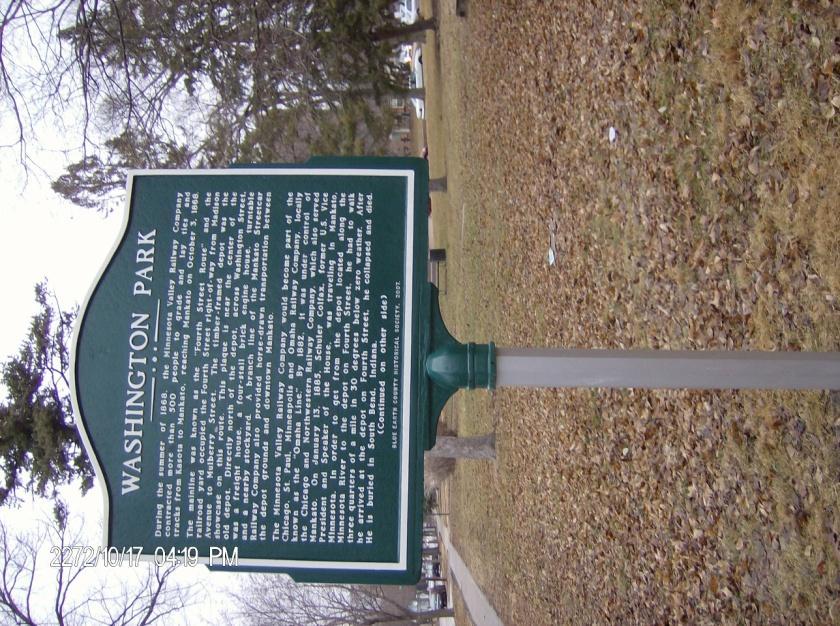
1 MINNESOTA ARCHITECTURE - HISTORY INVENTORY FORM Property Location Property Name: Washington Park Address: 215 N 4th Street County: Blue Earth City/Twp: Mankato PIN: R Legal Description: Lots 1, 2, 3, 4, and 5, in block 46, in the Town of Mankato according to the recorded plat thereof made by Elias D. Bruner, and being block 66, according to the recorded plats of said town made by John J. Everett and A.D. McSweeney, Lots 1, 2, 3, 4 and 5, in block 65, in the town of Mankato according to the recorded plat thereof made by A.D. McSweeney the same being the north westerly ½ of block 65, in the town of Mankato according to the recorded plat thereof made by John J. Everett, and being the north-westerly ½ of Market Square in the Town of Mankato according to the recorded plat thereof made by Elias D. Brunner, and sometimes called Block 47, according to said plat, for a public park only to be always open to the public without changes, under regulations by the common council of said city Property Information Architect: Not known Style: Open Space State Historic Context: Railroad and Agricultural Date Constructed: 1915 Development Historic Use: Park Property Type: Site NR Status: Not listed Present Use: City Park Local Historic Context: Civic Services 1850s-1950s Survey Name: Mankato Local Designation Survey Prepared by: Courtney Kramlinger Survey Date: September 27, 2013 Description: Washington Park is located in the central part of the City of Mankato and is bounded by N. 4 th Street, E. Mulberry Street, Washington Court, and E. Washington Street. Washington Park encompasses 3.08 acres and offers amenities such as a playground, picnic tables, benches, passive green space, and mature trees. Washington Park contains a variety of tree species including Hawthorn, Hackberry, Spruce, Linden, Sugar Maple, Red Maple, Norway Maple, Cedar, Ash, Oak, Elm, Pine, and Honeylocust. There are walking trails which intersect the park forming an "X" on each half of the park which were present in the park as early as The paths were originally a combination of dirt and gravel and were paved in 1978 as part of a bond referendum. In 2001, part of E. Plum Street was vacated which previously ran through the middle of Washington Park connecting both halves of the park and providing more green space.
2 Playground equipment was introduced in the late 1970's when a steel climber was installed. Wooden playground equipment was installed in the early 1980's which was replaced in The steel climber and wooden playground equipment were removed from Washington Park as they were deemed unsafe. History: The Washington Park neighborhood is clustered along the long, wide central park space. Most of the early residents in the Washington Park neighborhood were German, Irish, Scandinavian, and Lebanese immigrants; this was the blue collar area of Mankato. They built their houses in the popular Victorian architectural style, but were more modest than those of the more wealthy neighborhoods. Their homes were of smaller scale and included mass-produced embellishments that were ordered through catalogues. The houses reflect the neighborhood's status as a working class district, occupied by laborers, shop employees and trades people. The proximity of the neighborhood to the central commercial and industrial core meant many of these people could easily get to work. During the summer of 1868, the Minnesota Valley Railway Company contracted more than five hundred people to grade and lay ties and tracks from Kasota to Mankato, reaching Mankato on October 3, The main railroad line was known as the "Fourth Street Route" and the railroad yard occupied the Fourth Street right-of-way from Madison Avenue to Mulberry Street. A timber-framed depot was the showcase of this route; there is a "Heritage Plaque" located near the center where the depot once stood. Directly north of the depot, across Washington Street, was a freight house, a fourstall brick engine house, turntables, and a nearby stockyard. A branch line of the Mankato Streetcar Railway Company also provided horse-drawn transportation between the depot grounds and downtown Mankato. The Minnesota Valley Railway Company would become part of the Chicago, St. Paul, Minneapolis, Omaha Railway Company, locally known as the Omaha Line. By 1882, it was under control of the Chicago and Northwestern Railway Company, which also served Mankato. The Omaha line decided to abandon its tracks on Fourth Street in favor of a route along the Minnesota River; however, they did not officially vacate the site until March 11, Former speaker of the U.S. House of Representatives and later Vice President to President Ulysses Grant, Schuylor Colfax, was passing through Mankato on January 13, 1885 in route to Rock Rapids, Iowa. It was reported to be 20 degrees below zero that day when Vice President Colfax arrived at the Milwaukee station and walked across town in the severe weather to the Omaha depot on Fourth Street near the present Washington Park. Vice President Colfax sat down in the waiting area and passed away. The City of Mankato purchased the property for $8,540 in 1913, and in 1915, Washington Park was dedicated by the City of Mankato officials and citizens. The final papers in the transfer of Washington Park to the City of Mankato were turned over to City Clerk Bates on March 30, 1915 by Judge Lorin Cray. The purchase of the Washington Park was not a smooth process. Judge Lorin Cray purchased two one-half blocks of railroad property in 1906 between Washington and Mulberry Streets for the city; this land would later become Washington Park. At that time, the Civic League, mayor and the majority of the council approached Judge Lorin Cray to draw a contract for the purchase of the land and property owners along N. 4 th Street raised $2,100 toward the purchase; two councilmen and the city recorder were opposed. The city recorder refused to sign the contract for the purchase time and time again at council meetings. The mayor and the people wanted the park, and it was decided by law that the city recorder had no right to hold up what the majority of the council voted for. Like other parks in Mankato, Washington Park was once dominated by a large fountain which has since been lost. The fountain was located in the southwest portion of the park, adjacent to N. 4 th Street. The fountain was removed in the mid 1960's due to neglect and the foundation of the fountain was still in place up until the 1970's. The area where the fountain used to sit is now covered with grass.


3 Evaluation: The site is not currently listed on the National Register of Historic Places. Integrity: Washington Park has good integrity historically for its role as a social gathering space when it served as the location of a depot and as a park as it has for over 100 years. Significance: Washington Park has significance locally because it has character, interest, and value as part of the development and heritage of the City of Mankato. Washington Park is also significant for its physical characteristics which represent a familiar visual feature of the Washington Park neighborhood and City as a whole. Condition: Washington Park is in good condition. The lawns are well groomed and maintained. Sources: Blue Earth County Historical Society. Vertical Files. Accessed September 25, Zahn & Associates LLC, Thomas R. (2010) City of Mankato Historic Context Study. Retrieved from Park.pdf Photographic Documentation: Photo of former fountain at Washington Park; Photo of former fountain at Washington Park; November 5, 1941.
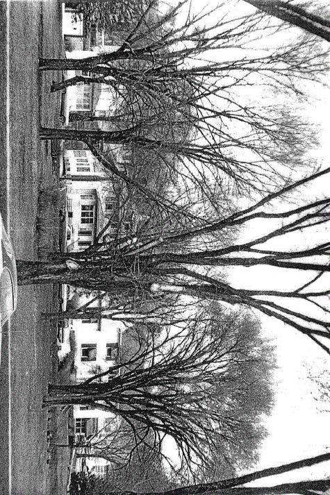
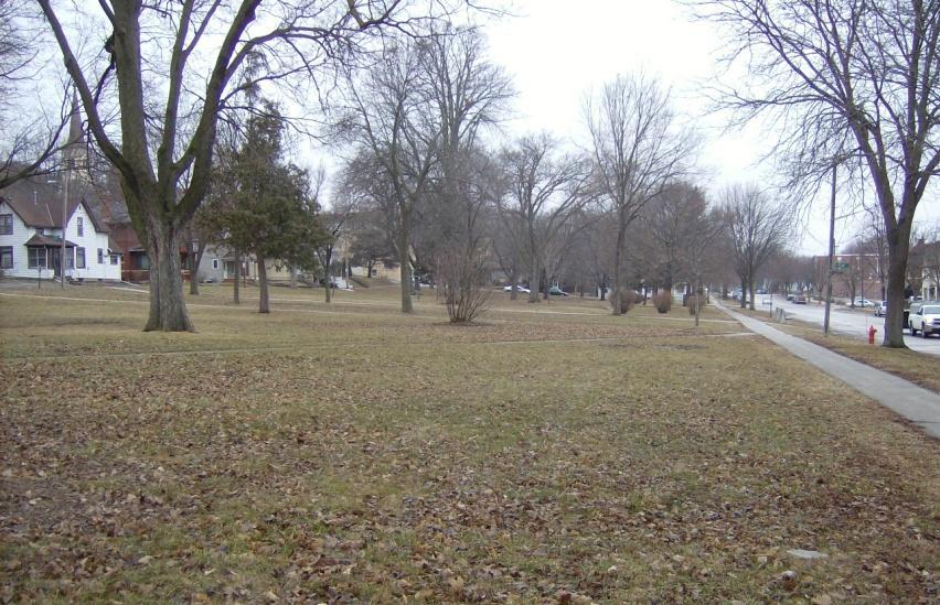
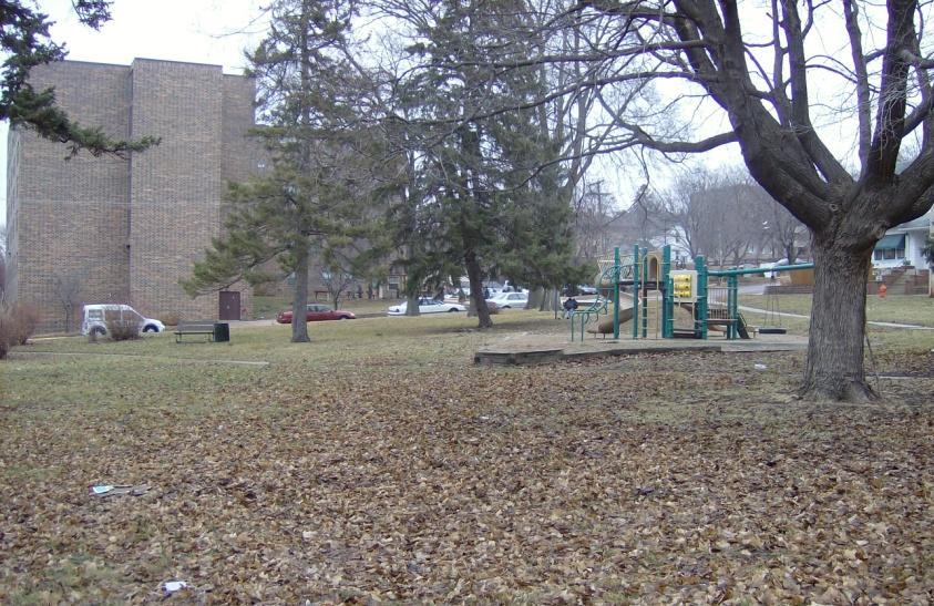
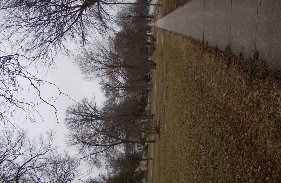
4 Photo Washington Park as it appears today.
5 Sanborn Maps: October 1884 Sanborn Map: Shows location of former railroad.
6 December 1914 Sanborn Map: Shows the vacated railroad, Washington Park runs along N. 4 th Street from Mulberry to Washington.
Mankato s Transportation Heritage
 Mankato s Transportation Heritage City of Mankato Mankato Heritage Preservation Commission May 11, 2017 1. Union Depot, 112 S. Riverfront Drive, c. 1896. The railroads were Mankato s dominant transportation
STATE OF IOWA. Historical and Architectural Survey for 2008 Flood Projects in Vinton, Benton County
 STATE OF IOWA CHESTER J. CULVER GOVERNOR PATTY JUDGE LT. GOVERNOR DEPARTMENT OF PUBLIC DEFENSE IOWA HOMELAND SECURITY AND EMERGENCY MANAGEMENT DIVISION DAVID L. MILLER, ADMINISTRATOR Historical and Architectural
PIONEER PARK. City of Des Peres Parks Master Plan. SWT Design 46 INTRODUCTION
 PIONEER PARK INTRODUCTION Pioneer Park is a 7 acre neighborhood park located east of Interstate 270 and south of Manchester Road along Tallie Road. The park is situated in a residential neighborhood with
and plant some trees, but that was only accomplished through state and federal work-relief programs.
 PEAVEY LOCATION AND HISTORY Peavey Park sits in the Phillips Community on a large block bounded by major streets: Franklin Avenue, Chicago Avenue, and Park Avenue. The southern continue through to Chicago
Historic Property Report
 Historic Name: Shadle Park Reservoir Property ID: 708465 Location Address: Location Comments: GeographicAreas: 4302 N Belt St, Spokane, Washington, USA Wellesley Ave & N Belt St Spokane,T25R42E01,SPOKANE
MINNESOTA HISTORIC.PROPERTIES INVENTORY FORM. Yes_ No X Restricted
 HISTORIC NAME: CURRENT NAME: LEGAL DESC.: MINNESOTA HISTORIC.PROPERTIES INVENTORY FORM Hartley Sugar Camp W % of Gov't. Lot 3 and T55, R24, Sec. 9 COUNTY: Itasca CITY/TWP.: Trout Lake Twp. ADDRESS: of
Architectural Inventory Form
 OAHP1403 Rev. 9/98 COLORADO CULTURAL RESOURCE SURVEY Architectural Inventory Form Official eligibility determination (OAHP use only) Date Initials Determined Eligible- NR Determined Not Eligible- NR Determined
Figure San Dimas Bonita at San Dimas Avenue (view looking west)
") The adjoining neighborhood has an eclectic assortment of building types and uses, including: the historically significant but not architecturally or visually noteworthy San Dimas Lemon Association Packing
The adjoining neighborhood has an eclectic assortment of building types and uses, including: the historically significant but not architecturally or visually noteworthy San Dimas Lemon Association Packing
Northeast Quadrant Distinctive Features
 NORTHEAST QUADRANT Northeast Quadrant Distinctive Features LAND USE The Northeast Quadrant includes all the area within the planning area that is east of Interstate 5 and to the north of State Route 44.
MPRB: Southwest LRT Community Advisory Committee Issues and Outcomes by Location Current to: 12 November 2010
 MPRB: Southwest LRT Community Advisory Committee Issues and Outcomes by Location Current to: 12 November 2010 This is a compilation of issues and outcomes identified by the CAC. It is a work in progress,
MUSCATINE COUNTY BOARD OF SUPERVISORS
 MUSCATINE COUNTY BOARD OF SUPERVISORS Robert Howard, District One Matt Bonebrake, District Two Scott Sauer, District Three Nathan Mather, District Four Jeff Sorensen, District Five AGENDA 9:00 a.m. 1.
National Register of Historic Places Multiple Property Documentation Form
 NPS Form 10-900-b OMB No. 1024-0018 Revised Aug. 2002 Expires 12-31-2005 Multiple Property Documentation Form This form is for use in documenting multiple property groups relating to one or several contexts.
MAPPING UNSHELTERED HOMELESSNESS IN INDIANAPOLIS ISSUE C17-20 NOVEMBER 2017
 MAPPING UNSHELTERED HOMELESSNESS IN INDIANAPOLIS ISSUE C17-20 NOVEMBER 2017 AUTHOR Chris Holcomb, Graduate Student, School of Public and Environmental Affairs, IUPUI 334 N. Senate Avenue, Suite 300 Indianapolis,
AGENDA ITEM 5 D WAKULLA ENVIRONMENTAL INSTITUTE (WEI) TRAIL FEASIBILITY STUDY
 TRAIL FEASIBILITY STUDY") March 19, 2018 AGENDA ITEM 5 D WAKULLA ENVIRONMENTAL INSTITUTE (WEI) TRAIL FEASIBILITY STUDY TYPE OF ITEM: Action STATEMENT OF ISSUE The Wakulla Environmental Institute (WEI) Trail is one of several trails
March 19, 2018 AGENDA ITEM 5 D WAKULLA ENVIRONMENTAL INSTITUTE (WEI) TRAIL FEASIBILITY STUDY TYPE OF ITEM: Action STATEMENT OF ISSUE The Wakulla Environmental Institute (WEI) Trail is one of several trails
Photo Album Intact/Slightly Altered. Eligible, see Statement of Significance. Roadside Development on Minnesota Trunk Highways,
 Historic Name CS # 5202 Other Name SHPO Inv # Location Hwy District Reference City/Township County Courtland Township Nicollet Acres 4.6 Twp Rng Sec 110N 30W Sec 22 Rest Area Class 4 USGS Quad UTM New
In 1850, Congress passed a law donating two and one half million acres to the State of Illinois for the use of the Illinois Central Rail Road.
 Merna The town of Merna was founded by primarily Irish and German farmers. Their faith and families were an integral part of who they were. There was and still is today a strong sense of community. Most
Chicago Great Western RR
 Chicago Great Western Railroad CHIGAGO GREAT WESTERN RAILROAD................................................ Inc. in IL, August 19, 1909 756.112 mi. First main track 59.124 mi. Second and other main tracks
TOWNSHIP OF HILLSIDE, NJ.
 TOWNSHIP OF HILLSIDE, NJ. HILLSIDE Formed as Township: 1913 1970 Population: 21,636 Land Area 2.70 square miles The initial settlement of the township now known as present day Hillside followed shortly
RAILROAD AND WAREHOUSE COMMISSION An Inventory of Its Chief Engineer s Case Files
 MINNESOTA HISTORICAL SOCIETY Minnesota State Archives RAILROAD AND WAREHOUSE COMMISSION An Inventory of Its Chief Engineer s Case Files OVERVIEW OF THE RECORDS Agency: Series Title: Dates: 1901-1924. Abstract:
BACKROADS BICYCLE/AUTOMOBILE TOUR OF MIDDLESEX, VERMONT
 BACKROADS BICYCLE/AUTOMOBILE TOUR OF MIDDLESEX, VERMONT (created and published by the Middlesex Historical Society) Welcome to a 25-mile self-guided historical tour of the backroads of Middlesex. You may
// LEARN // ENGAGE // VOLUNTEER // DONATE // PROJECT OVERVIEW MAP
 // LEARN // ENGAGE // VOLUNTEER // DONATE // PROJECT OVERVIEW MAP PROJECT OVERVIEW MAP The Atlanta BeltLine is a dynamic and transformative project for Atlanta. Through the development of a new transit
City of Haslett. City of East Lansing. City of East Lansing
 Central Park North (Nancy L. Moore Park) Lake Park North Expansion White Park Expansion #2 White Park Expansion #1 County East East Haslett East East TF87-212 Acquisition $90,000.00 Park. TF08-138 Acquisition
Society Member to Supervise the Building of James Monroe s Birthplace House Charles Belfield, a councilor of the War of 1812 Society in the
 Society Member to Supervise the Building of James Monroe s Birthplace House Charles Belfield, a councilor of the War of 1812 Society in the Commonwealth of Virginia has been designated as the supervisor
FLAGLER WORKER S HOUSE FORT DALLAS PARK S.E. 4 STREET
 FLAGLER WORKER S HOUSE FORT DALLAS PARK 60-64 S.E. 4 STREET Designation Report City of Miami REPORT OF THE CITY OF MIAMI PLANNING DEPARTMENT TO THE HERITAGE CONSERVATION BOARD ON THE POTENTIAL DESIGNATION
4.0 FACILITIES INVENTORY
 4.0 FACILITIES INVENTORY 4.1 PARK LEVEL OF SERVICE STANDARDS (LOS) Based on current City of Longview Parks and Recreation Level of Service (LOS) Standards (Figure G), the City currently has a deficiency
STUDENT NAME: Nakeita Clarke INTRODUCTION. Learning Places Fall 2018 SITE REPORT #la Zuccotti Park
 Learning Places Fall 2018 SITE REPORT #la Zuccotti Park An example of the typical usage of Zuccotti Park in lower Manhattan. Some people use the park as a shortcut, while others use it as an area for eating
DOWNTOWN EAST RESTAURANT AND RETAIL SPACE. Matt Friday. Senior Vice President
 DOWNTOWN EAST RESTAURANT AND RETAIL SPACE AVAILABLE for lease Matt Friday Senior Vice President 612 336 4209 matt.friday@cbre.com David Daly Vice President 612 336 4319 david.daly@cbre.com Eric Sheaffer
2. Goals and Policies. The following are the adopted Parks and Trails Goals for Stillwater Township:
 D. PARKS AND TRAILS 1. Introduction Stillwater Township s population is relatively low, with most residents living on rural residences on large lots. The need for active park space has been minimal in
Where Business and Nature thrives
 Where Business and Nature thrives WHERE BUSINESS AND NATURE THRIVES Situated on a picturesque 43-acre forested hillside in the center of Tulsa, Warren Place offers an ideal location, incomparable amenities,
Vision for Kirkholt. Our proud history. From ancient knights to Victorian landmarks
 Vision for Kirkholt Our proud history From ancient knights......to Victorian landmarks Take the family heritage trail to discover historical gems on your doorstep See map inside FREE STICKERS! The Vision
Hwy Retaining Wall/ Sea Wall. Not Eligible, see Statement of Significance Also member of listed NR district: Mantorville Historic District
 Historic Name CS # 2007 Other Name SHPO Inv # Location E and W sides of TH 57 between 6th St and 7th St Hwy District Reference City/Township County Mantorville, City of Dodge Acres Twp Rng Sec 107N 16W
Town: Sharon Place (neighborhood or village): Sharon. ame of Area: Present Use: Date (month / year): July 2008
: Sharon. ame of Area: Present Use: Date (month / year): July 2008") FORM A - AREA MASSACHUSETTS HISTORICAL COMMISSION MASSACHUSETTS ARCHIVES BUILDING 220 MORRISSEY BOULEVARD BOSTON, MASSACHUSETTS 02125 Photograph Assessor s Sheets USGS Quad Area Letter Form Numbers in
FORM A - AREA MASSACHUSETTS HISTORICAL COMMISSION MASSACHUSETTS ARCHIVES BUILDING 220 MORRISSEY BOULEVARD BOSTON, MASSACHUSETTS 02125 Photograph Assessor s Sheets USGS Quad Area Letter Form Numbers in
Heritage Survey: Stellenbosch Rural Areas
 Heritage Survey: Stellenbosch Rural Areas by and Stewart Harris - June 2004 Sub Area Name Catalogue Number Jonkershoek 02.06 Property Name Glenconner, Jonkershoek, Stellenbosch District Farm Number 345/7
HIGHWAY RAIL GRADE CROSSING CONSOLIDATION PROGRAM
 HIGHWAY RAIL GRADE CROSSING CONSOLIDATION PROGRAM To decrease unnecessary train traffic exposure to life and property, promote public safety, and improve traffic conditions, the Texas Department of Transportation
RAY YENKANA Willowbrook Cr, Dawson Creek BC Canada $2,847,000
 1716 Willowbrook Cr, Dawson Creek BC Canada For SALE $2,847,000 This is a rare find, 32 townhomes in Dawson Creek, BC. Excellent investment in a single title multi family complex. Vendor has upgraded this
A History of West Chicago
 A History of West Chicago The Prairie Prairie Inhabitants Winfield Mounds Dickson Mounds, near Lewistown, in southern Illinois. An example of what Native burial mounds look like. First Permanent Settlers
CONTENTS. 1 Introduction Always Moving Forward while Building on the Past A Dynamic Destination... 5
 2010 STRUCTURE PLAN - 2 - CONTENTS 1 Introduction... 5 1.1 Always Moving Forward while Building on the Past... 5 1.2 A Dynamic Destination... 5 2 Map A... 6 Exhibition Place and its Neighbours... 7 3 Demonstration
F INAL DESIGN PROPOSAL. Knife River Village MASTER PLAN
 Knife River Village MASTER PLAN The Knife River Village idea is the culmination of the community design process with as much community feedback incorporated as possible into the final design proposal.
19 ORCHARD COOMBE WHITCHURCH HILL F OXFORDSHIRE
 19 ORCHARD COOMBE WHITCHURCH HILL F OXFORDSHIRE 19 ORCHARD COOMBE WHITCHURCH HILL F OXFORDSHIRE Pangbourne on Thames 2 miles (London Paddington within the hour) F Reading 10 miles (London Paddington 27
Community Development Department Council Chambers, 7:30 PM, December 20, 2012
 STAFF REPORT 2012-56P: Alley Vacation Community Development Department Council Chambers, 7:30 PM, December 20, 2012 To: From: Re: Paul Luke, Chairman, Skokie Plan Commission Mike Voitik, Planning Technician
ORDINANCE NO WHEREAS, Marina District Development, LLC is the fee simple owner of the following described real estate, to wit:
 SPONSOR: Councilman Kalwinski PETITIONED BY: Marina District Development, LLC ORDINANCE NO. 9304 AN ORDINANCE VACATING A 859 FOOT PORTION OF 5 th AVENUE, MORE OR LESS, LYING BETWEEN 112 th STREET INDIANAPOLIS
CITY PLANNING COMMISSION June 22, 2011, Calendar No. 27
 CITY PLANNING COMMISSION June 22, 2011, Calendar No. 27 IN THE MATTER OF IN THE MATTER OF an application, submitted by the Department of Transportation, pursuant to Sections 197-c and 199 of the New York
SAN ANTONIO RIVER IMPROVEMENTS PROJECT. April 27, 2009
 SAN ANTONIO RIVER IMPROVEMENTS PROJECT April 27, 2009 1 Project Limits 2 Project Partners City of San Antonio Provides project funding for project amenities (i.e.. Sidewalks, Landscaping, Lighting, etc.)
Gardner: overview. Santa Fe, Oregon, and California National Historic Trails UNINCORPORATED JOHNSON COUNTY OLATHE UNINCORPORATED JOHNSON COUNTY
 Santa Fe, Oregon, and California ational Historic Trails : overview 99: p.134 100: p.135 GARDER JUCTIO 102: p.137 56: p.126 EDGERTO Burlington orthern Intermodal and Logistics 98: p.133 101: p.136 S Waverly
THE SETTING REGION COMMUNITY ANALYSIS
 THE SETTING REGION COMMUNITY ANALYSIS REGION Historical Setting The Crane Lake waterway pre-dates the American Indians who traveled its waters for generations before it became a fur-trading route for the
Pre-Leasing New Retail Development
 Pre-Leasing New Retail Development Commons on Regal - Retail Shopping Center 5415 South Regal Road Spokane, WA 99223 Lease Overview Available SF: Larger Users Lease Rate: Lot Size: Building Pads: 1,500
The Atlanta BeltLine. & Sustainable Development GAFM Conferance. // March 25, 2014
 The Atlanta BeltLine & Sustainable Development GAFM Conferance // March 25, 2014 04/22/2014 Atlanta BeltLine // 2013 Page 1 // Organizational Structure Project Owner and Sponsor Redevelopment Authority
PROPERTY INFORMATION PACKAGE: 412 Webster St
 C O M M U N I T Y D E V E L O P M E N T 4 0 0 B O A R D M A N A V E N U E T R A V E R S E C I T Y, M I 4 9 6 8 4 C O N T A C T : J E A N D E R E N Z Y 2 3 1. 9 2 2. 4 5 1 3 j d e r e n z y @ g r a n d
C E N T R A L C A T S K I L L S
 120 C E N T R A L C A T S K I L L S Central Catskills Once out of the southern parts of the Catskills, the Long Path enters the more well traveled and civilized regions. The trail joins the Devil s Path,
21 TABLES OF SPECIAL ORDINANCES TABLE C - VACATING OF STREETS AND ALLEYS
 21 TABLES OF SPECIAL ORDINANCES TABLE C - VACATING OF STREETS AND ALLEYS Alley - N. Albemarle St. to Eberts Lane 7-16-85 X-321 Alley - N. Albemarle St. to Cambridge St. 6-19-90 Y-411 Alley - Bare to Park
APPENDIX OFFICIAL MAP ORDINANCE OF HAMILTONBAN TOWNSHIP OFFICIAL MAP NARRATIVE
 APPENDIX A OFFICIAL MAP ORDINANCE OF HAMILTONBAN TOWNSHIP OFFICIAL MAP NARRATIVE INTRODUCTION: The Official Map of Hamiltonban Township has been prepared to identify those lands and features that Hamiltonban
M E S T I Z O C U R T I S P A R K
 ARAPAHOE CONNECTION TO BUS ROUTE AT ND AND LAWRENCE, FUTURE LIGHT RAIL STATION LEGEND SOCIAL TRAIL FLAGSTONE PAVING TO RESTORE/MAINTAIN CONCRETE PAVING DIAGONAL CURVILINEAR SOCIAL ROUTE IS OUT OF HISTORIC
Our Region. Mountains of Northeast Tennessee
 Rails to Trail Our Region Our Region Mountains of Northeast Tennessee Brief History / Whose Idea David Ornduff, City of Elizabethton 1991 Protect the corridor *Steve Darden, Mayor of Johnson City 2005,
Chapter 2: Summary of Existing Open Space System
 Chapter 2: Summary of Existing Open Space System In 1976, the Wake County Board of Commissioners established the Wake County Parks and Recreation Department in order to provide park facilities and programs
ORDI NANC E NO
 ORDI NANC E NO. 13622 AN ORDINANCE to amend the Official Zoning Map of the City of Des Moines, Iowa, set forth in Section 2A-5 of the Municipal Code of the City of Des Moines, 1991, by rezoning and changing
This section evaluates the projected traffic operations and circulation impacts associated with the proposed upgrade and expansion of the LWRP.
 4.5 TRAFFIC AND CIRCULATION This section evaluates the projected traffic operations and circulation impacts associated with the proposed upgrade and expansion of the LWRP. 4.5.1 Environmental Setting Existing
3.0 EXISTING PARK & RECREATION SPACE
 3.0 EXISTING PARK & RECREATION SPACE TOWN PARK & RECREATION SPACE An inventory of current parks and recreation area in the Town of Cedarburg is shown in Table 3. These areas total roughly 381.89 acres.
- Ranch - BMT BMT. Pete Clark. The enclosed information has been obtained from sources that we deem reliable; Offered at $6,000,000
 68720 Parkfield Coalinga Road Parkfield, California 93451 San Miguel, California The enclosed information has been obtained from sources that we deem reliable; however, it is not guaranteed by Clark Company
COLLEGE STREET STUDY Community Consultation Meeting. December 2015
 COLLEGE STREET STUDY Community Consultation Meeting December 2015 2 Agenda 6:30 pm Introductions, Agenda Review and Welcome 6:40 pm Presentation Planning Recommendations 7:30 pm Questions and Discussion
Segment 4: Hokah to Mound Prairie
 Root River Wildlife Management Area The main unit of this WMA is located just north of the Root River and the city of Hokah. Its 443 acres include mixed hardwoods of oak, basswood, ash, cottonwood, elm
7:00 p.m. General meeting called to order. Paul Conte, Chair 7:05 p.m. Introductions Reminder: All JWN members should fill out and return a sign-in
 Agenda 7:00 p.m. General meeting called to order. Paul Conte, Chair 7:05 p.m. Introductions Reminder: All JWN members should fill out and return a sign-in card to receive a ballot. All guests are requested
Striders Day 3: Thursday, May 24
 Striders Day 3: Thursday, May 24 Microsoft Campus, Bridle Trails State Park, Redmond (10.9 miles) Gather at Microsoft Visitors Center, 9:30, ½ mile walk from Overlake TC. Departure: Redmond Transit Center
TEMPE BEACH PARK - RECOMMENDATIONS
 TEMPE BEACH PARK - RECOMMENDATIONS Tempe Beach Park has the potential to become a regional destination park, but it suffers from a host of physical and operational problems, as well as structural flaws.
The Covered Bridges of Preble County. Past, Present and Future By: R. Kyle Cross, P.E., P.S.
 The Covered Bridges of Preble County Past, Present and Future By: R. Kyle Cross, P.E., P.S. The History of the 8 Covered Bridges There are 8 covered bridges in Preble County. Only 2 of them are moved for
Segment 2: La Crescent to Miller s Corner
 goal of the USFWS refuges is to conserve, protect and enhance fish, wildlife and plants and their habitats for the continuing benefit of the American people. Refuge lands are used largely for fishing,
M. Spina, Councillor J. Cowden, School District No. 73 N. DeCicco, Projects and Planning Supervisor, City of Kamloops
 MINUTES OF A MEETING OF THE KAMLOOPS PARKS AND RECREATION COMMITTEE HELD ON WEDNESDAY, NOVEMBER 26, 2014, AT 7:00 AM IN THE TOURNAMENT CAPITAL CENTRE, MEETING ROOM "D" RECOMMENDATION: That Council authorize
MLS # $3,733 per Month 5,960 SF Freestanding Retail Building with Office, Warehouse, & Showroom Space in Panama City, FL
 MLS # 668927 $3,733 per Month 5,960 SF Freestanding Retail Building with Office, Warehouse, & Showroom Space in Panama City, FL 7540 Highway 22 Panama City, FL Presented By: Darren Haiman Nations Real
8,844 SF office micro-campus for sale or lease
 8,844 SF office micro-campus for sale or lease Escondido, CA 92025 MARC POSTHUMUS Vice President +1 760 930 7950 marc.posthumus@colliers.com CHRIS WILLIAMS Associate Vice President +1 760 930 7952 chris.williams@colliers.com
X Respond to staff direction
 Page 1 of Report TO: Community Services Committee Corporate Services Division SUBJECT: Apeldoorn Mundalization Project Report Number: Report Date: February 17, 2010 File Number(s): Ward(s) Affected: 1
The Master Plan, Walkability, and Trails in the City of Solon. April 23, 2018
 The Master Plan, Walkability, and Trails in the City of Solon April 23, 2018 Tonight s topics 1. Existing trail options in the City of Solon 2. Potential trail options 3. How trails and walkability converge
Heritage Character Area Zoning - Edmonton s Approach to Preserving(?) Community Character
 Community Character") Heritage Character Area Zoning - Edmonton s Approach to Preserving(?) Community Character Federation of Calgary Communities Community Planning Exchange November 4, 2017 City of Edmonton CITY
Heritage Character Area Zoning - Edmonton s Approach to Preserving(?) Community Character Federation of Calgary Communities Community Planning Exchange November 4, 2017 City of Edmonton CITY
HALL PARK LOCATION AND HISTORY EXISTING CONDITIONS AND CHARACTER LOCATION
 HALL PARK LOCATION LOCATION AND HISTORY Hall park straddles Lyndale Avenue on the city s near north side. This neighborhood was identified in a 1938 study of the city s playground needs as one of five
Memorable Designs, Unforgettable places
 Memorable Designs, Unforgettable places We create environments that connect people, introduce nature into life s moments and provide a backdrop against which unforgettable experiences unfold. DELRAY BEACH
National Register of Historic Places Continuation Sheet
 Section number N/A Page 1 Proposed Amendment to Wichita, Sedgwick County, Kansas The owner of the building at 141 S. Rock Island Avenue requests amendment to the boundaries of the East Douglas Historic
FOR SALE Bernard Avenue Kelowna, BC acre development site in the heart of Downtown Kelowna
 FOR SALE 426-454 Bernard Avenue Kelowna, BC PROPERTY DETAILS: 0.366 acre development site in the heart of Downtown Kelowna Previously approved for a mixed use development Well located in the heart of Downtown
New Orleans Historic District Landmarks Commission Nomination Report 210 State Street, former NOAH Campus July 17, 2014
 New Orleans Historic District Landmarks Commission Nomination Report 210 State Street, former NOAH Campus July 17, 2014 Meeting Date: July 17, 2014 Property Address: Owner: 210 State Street Children s
Arthur Carhart National Wilderness Training Center s Wilderness Investigations High School
 Arthur Carhart National Training Center s Investigations High School 101/Lesson 2 (OPTION 2B) Introducing the Act Goal: Students will understand the difference between wild spaces and federally designated
Finch-Marshall Railway Collection
 Inventory of the Finch-Marshall Railway Collection In the Regional History Center RC 54 1 INTRODUCTION The records on the National Railway System came to the Northern Illinois University Archives in 1976.
throu Booth Hill Green Belt
 s k r a p s l l u b m u r T Explore gh Geocaching throu Booth Hill Green Belt This was originally a concept to try and preserve some of the land in our town, without hurting the developers that are creating
To Wellness. To Wellness PASSPORT PASSPORT. Partners. Partners. Ashland County Health & Human Services 630 Sanborn Avenue, Ashland, WI
 Partners Ashland County Health & Human Services 630 Sanborn Avenue, Ashland, WI Ashland Bretting Center 320 4th Avenue W., Ashland, WI PASSPORT Bayfield County Health Department 117 E. 6th Street, Washburn,
HISTORIC SITE FORM HISTORIC SITES INVENTORY
 HISTORIC SITE FORM HISTORIC SITES INVENTORY 1 IDENTIFICATION Name of Property: House at 569 Park Avenue PARK CITY MUNICIPAL CORPORATION (10-08) Address: 569 Park Avenue City, County: Park City, Summit
Community Input Meeting. Fairgrounds Master Planning Update. January 7, 2016, 7 pm
 Community Input Meeting Fairgrounds Master Planning Update January 7, 2016, 7 pm Fiesta Hall Santa Clara County Fairgrounds 355 Tully Road, San Jose, CA Tonight s Agenda 1) Board of Supervisors Direction
Where Business and Nature thrive
 WARREN PLACE Where Business and Nature thrive WHERE BUSINESS AND NATURE THRIVE Situated on a picturesque 43-acre forested hillside in the center of Tulsa, Warren Place offers an ideal location, incomparable
The Atlanta BeltLine. Project Overview Map
 The Atlanta BeltLine Project Overview Map The Atlanta BeltLine is a dynamic and transformative project for Atlanta. Through the development of a new transit system, multi-use trails, greenspace, and affordable
Classifications, Inventory and Level of Service
 Classifications, Inventory and Level of Service Section 3 Kenmore Park, Recreation and Open Space Plan 1 P a g e Classifications and Inventory Park Classifications Kenmore classifies its parks based upon
Appendix C. Cultural Heritage Properties
 Appendix C Cultural Heritage Properties Existing Conditions Report Page 1 Don River Mouth Naturalization and Port Lands Flood Protection Project Appendix C: Inventory of Cultural Heritage Properties in
ORDINANCE NO. 15,670
 ORDINANCE NO. 15,670 AN ORDINANCE to amend the Municipal Code of the City of Des Moines, Iowa, 2000, adopted by Ordinance No. 13,827, passed June 5, 2000, as heretofore amended, by amending Sections 114-361.01,
Difficult Run Stream Valley Park
 Difficult Run Stream Valley Park The more intense mountain bikers have known about for Difficult Run for some time. Equestrians have known it longer. Eight miles of unpaved trail, the Rails to River Trail
Minutes of Board Meeting
 Minutes of Board Meeting University Hill Farms Association February 11, 2017 Approved May 13, 2017 Covenant Presbyterian Church Officers and Board Members Present: Peter Hughes, Jacki Lawton, Kathy Thompson,
NPS Form a OMB No (8-86) Expires
 Expires") Section: F Page 247 Railroads in Minnesota, 1862-1956 Figures Railroad Roadway Edge of Right of Way Edge of Right of Way Railroad Bed Figure 1. Railroad Corridor, Young America vicinity, ca. 1915 Section:
Section: F Page 247 Railroads in Minnesota, 1862-1956 Figures Railroad Roadway Edge of Right of Way Edge of Right of Way Railroad Bed Figure 1. Railroad Corridor, Young America vicinity, ca. 1915 Section:
Much of the information which follows is included by kind permission of the Tynedale Council (now defunct) and is based on its brochure.
 and is based on its brochure.") The Tyne Green Trail This easy going circular walk is on level ground throughout. It follows the course of the River Tyne between Hexham Bridge and the turning point just past Watersmeet. The return is
The Tyne Green Trail This easy going circular walk is on level ground throughout. It follows the course of the River Tyne between Hexham Bridge and the turning point just past Watersmeet. The return is
BASSETTS CREEK SECTION CONTENTS: BASSETTS CREEK BRYN MAWR LUCE LINE
 BASSETTS CREEK SECTION CONTENTS: BASSETTS CREEK BRYN MAWR LUCE LINE GLENWOOD AVE MULTI-USE DIAMONDS VINCENT AVE N MORGAN AVE N PENN AVE N DOG PARK MULTI-USE FIELDS PLAYGROUND AK E RD S CHESTNUT AVE DA
City of Oak Harbor Parks & Descriptions
 City of Oak Harbor Parks & Descriptions North West Section Koetje Park - NE 7 th Avenue (3.5 acres) Neighborhood and Community Park with playgrounds on one tot lot, one soccer/practice field, picnic tables,
MINUTES TOWN COUNCIL TOWN OF SHENANDOAH REGULAR MEETING January 9, 2018
 MINUTES TOWN COUNCIL TOWN OF SHENANDOAH REGULAR MEETING CALL TO ORDER: The Shenandoah Town Council held its regular meeting on Tuesday,, at 7:00 p.m., with Mayor Clinton O. Lucas, Jr., presiding. The meeting
Ridgeway Centre Gorham Road, Ridgeway, Ontario
 FOr lease - New Development Ridgeway Centre Gorham Road, Ridgeway, Ontario Property Highlights This is the largest commercial development site located in the quaint town of Ridgeway, a neighbourhood of
CASS SCENIC RAILROAD. Cass, West Virginia. Written by Dan Whetzel Photography by Lance C. Bell
 CASS SCENIC RAILROAD Cass, West Virginia Written by Dan Whetzel Photography by Lance C. Bell m o u n t a i n d i s c o v e r i e s 49 Facing page: Cass Scenic Railroad s Heisler #6 departs from the depot
Contra Costa County Parks and Recreation Facilities
 Contra Costa County Parks and Recreation Facilities CONTRA COSTA COUNTY PUBLIC WORKS DEPARTMENT 255 GLACIER DRIVE MARTINEZ, CALIFORNIA 94553 Parks and Recreation Facilities 1 West County Lefty Gomez Community
Historic District Commission January 14, 2016 City of Hagerstown, Maryland
 Michael Gehr, chair, called the meeting to order at 4:30 p.m. on Thursday, January 14, 2016, in the Council Chamber, Second Floor, City Hall. A roster of the members of the commission and the technical
GrandWalk Trail. Planning & Development Study Kent County, MI
 Urban & Regional Planning Program Michigan State University UP 494/894 Planning Practicum GrandWalk Trail Planning & Development Study Kent County, MI Nicole Carson, Bianca Cobarzan, Andrea Dewey, Lisa
River Parks Trail: Tulsa, Oklahoma
 River Parks Trail: Tulsa, Oklahoma Purpose: The purpose of the River Parks Trail is to maintain, preserve, develop, and promote the Arkansas River for the economic and cultural benefit of the community.