Regions of Australia
|
|
|
- Cornelius Gibson
- 6 years ago
- Views:
Transcription


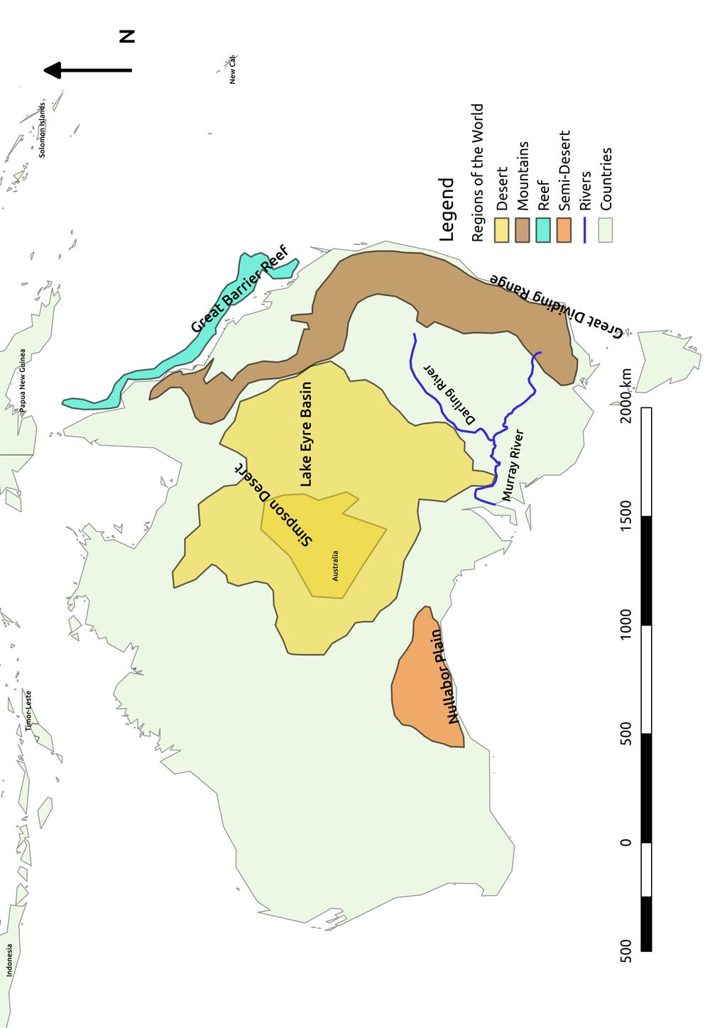
1 The map on the following page shows some geographical regions of Australia. Specifically the regions which are shown are the following: the Great Dividing Range the Great Barrier Reef the Lake Eyre Basin the Simpson Desert the Nullabor Plain The Murray and Darling Rivers are also shown as they have the largest drainage basin in Australia. The Great Dividing Range The Great Dividing Range is also known as the Eastern Highlands. It is Australia's largest mountain range and the 3rd longest range of mountains in the world. The Great Dividing Range is more than 3,500 km long, stretching from Victoria to Cape York in Queensland. In fact, the Great Dividing Range is not a single mountain range, but a series of ranges, upland areas and escarpments. Three Sisters, Great Dividing Range, NSW On the Eastern side of the mountains the rivers run down to the Pacific Ocean or Bass Strait and on the Western side the rivers mostly drain into the Murray and Darling Rivers. The mountains help to keep the interior of Australia dry by blocking rain from the East coast from crossing to the West. Some snow falls on parts of the Great Dividing Range in winter. Snow in mountains of New South Wales. Page 1/7
2 Page 2/7


3 In the North the climate is hot and humid and the mountains are covered in tropical rainforest. In the South the climate is temperate in the mountains, with cooler temperatures. Aboriginal people have lived in these mountains since soon after they reached Australia. However, the Great Dividing Range posed a serious obstacle to European explorers and settlers in Australia and also hindered the development of roads and railways. The Great Barrier Reef The Great Barrier Reef is the world's largest coral reef system and lies off the northeastern coast of Queensland. It is more than 2,300 km long and includes more than 900 islands and more than 2,900 reefs. The Great Barrier Reef was listed as a World Heritage Site in Many, many kinds of fish, birds and sea animals live in the Great Barrier Reef, some live nowhere else. There are more than 30 species of dolphins, whales and porpoises. Humpback whales have their babies in the waters of the Great Barrier Reef. There are 6 species of marine turtle in the Great Barrier Reef and Green Sea Turtle. Image by Brocken Inaglory. only 7 in the whole world. There are 242 species of birds, over 1,500 species of fish and over 4,000 species of shellfish. The Great Barrier Reef has a lot of smaller environments within it. A few of these are shallow coral reefs, deep coral reefs, sandy beaches, rocky beaches, sand banks, coral cays, mangroves and mudflats. It is a very popular place for people to visit, especially for snorkelling and diving, but also to stay on the islands and visit Coral reef the beaches and rocky shorelines. The Great Barrier Reef has been affected by pollution, shipping passing through it (which sometimes breaks the coral or spills nasty things into the sea), overfishing and the Crown of Thorns Starfish, which sometimes occurs in large numbers and eats the coral. The Great Barrier Reef has been affected by warmer water and an increase of carbon dioxide Page 3/7


4 in the water in recent years. People are trying to find ways to protect the reef and measure how much is damaged and work out what damages it, so that it can be managed to preserve it. Lake Eyre Basin The Lake Eyre Basin is a drainage area that has no outflow into a river or sea. it is one of the largest of these in the world. There are several deserts in this basin, which produce most of the dust in the Southern Hemisphere. The area is very dry and arid. When rain falls it drains along the creeks into Kati Thanda Lake Eyre, which only fills a few times a century. Sometimes Kati Thanda Lake Eyre Lake Eyre. Image: Matt Malone dries completely, leaving only a layer of salt. The evaporation rate is very high because this area is so dry. If the Murray and Darling Rivers flowed into Lake Eyre they would just replace the water lost to evaporation. If the Mississippi River flowed into Lake Eyre it would take 22 days to fill it. The Amazon River could fill it in 3 days. The surrounding deserts all contribute to the dry air and high evaporation rate. Lake Eyre salt crust The Simpson Desert The Simpson Desert is part of the Lake Eyre Basin. It is the 4th largest desert in Australia. The 3 larger deserts (the Great Victoria Desert, the Great Sandy Desert and the Tanami Desert) are all in Western Australia, North of the Nullabor Plain. The Simpson Desert lies over the Southwestern edge of the Great Artesian Basin, an enormous underground reservoir of Simpson Desert Page 4/7


5 fresh water. There are many natural springs of water bubbling up from the Great Artesian Basin in the Simpson Desert. The Simpson Desert contains the world's longest parallel sand dunes, which lie North South. The climate is very hot and dry. Temperatures can reach close to 50ºC in summer, with sandstorms. Winters are usually cool, but can have hot days. The rainfall is usually very low. the Simpson Desert is home to emus, many birds and a marsupial rat called the Kowari. Kowari. Image: Kořínek Milan Charles Sturt was the first European to see the Simpson Desert in 1844, but the first non-indigenous person to cross the desert was Ted Colson, who crossed it with camels in Aboriginal people knew of the location of springs and wells in the desert and a Wangkangurru man helped the surveyor David Lindsay to find water in Ted Colson, Simpson Desert, the desert in The Nullarbor Plain The Nullarbor Plain was named from the Latin words nullus ( not any ) and arbor ( tree ). It is indeed a place with very few trees. It stretches inland from the coast in southern Western Australia, where the Great Australian Bight (an open bay) forms a long curve. On the northern side, the Nullabor Plain has the Great Victoria Desert, the largest desert in Australia. The Nullarbor Plain has a desert climate with very little rain, summer Nullarbor Plain. Image: Page 5/7


6 temperatures close to 50ºC in the day and winter nights below freezing. The Nullarbor Plain is formed of a layer of limestone bedrock, which was the base of an ancient sea. It has steep cliffs fronting onto the sea. Caves in these cliffs sometimes form blowholes which blow fountains of spray into the air above the cliffs, sometimes several hundred metres inland. There are also underground rivers and lakes. The vegetation of the Nullarbor is mostly small, scrubby plants like Southern Hairy-nosed Wombat. Image: saltbush and bluebush. Animals include the southern Jason Pratt. hairy-nosed wombat, red kangaroos, dingoes, which also live in the desert. Crossing the Nullarbor is regarded as a significant achievement in Australia. The Murray and Darling Rivers The Murray River is Australia's longest river (2,508 km long), running from the Australian Alps, through New South Wales and Victoria, to the sea in South Australia. The Darling River is the 3rd longest river in Australia and flows into the Murray River. The rivers that feed the Darling River start in Queensland, although the Darling River itself only Flood on the Darling River, Painting by William Piguenit. runs in New South Wales. Together the Murray and Darling make the longest river system in Australia. The amount of water in the Murray and Darling Rivers varies from year to year. The Darling River often dries out completely. It is rare for the Murray River to dry out completely. In the 19 th century paddle steamers transported goods and people on both rivers. It is still possible to cruise on the Murrey River in an historic paddle steamer. Most of are Paddle steamer on the Murray River. Image: Scott Davis recreational. Both rivers have been affected by the the boats on the Murray River today Page 6/7


7 use of their water for irrigation, pollution from pesticides and fertilisers and droughts. The Darling River, in particular, has been in poor health. The Murray important to River is particularly indigenous Australians. Several language groups amongst the Aboriginal People along the river share a story about a hunter chasing a Murray cod (a fish), which then carved out the Murray River. In the story told by the people of Lake Alexandrina the hunter is called Ngurunderi and the Murray cod is called Pondi. The chase started in New South Wales, and Ngurunderi threw Murray Cod. Image: Codman spears at Pondi. In avoiding the spears, Pondi carved out the curves and branches of the river. Although Ngurunderi managed to spear Pondi in the tail, which made him jump forwards in a straight line, Pondi escaped into Lake Alexandrina. The Murray cod is only one of several native fish in these river systems. Many of these are endangered due to the bad health of the rivers and introduced fish. There are also turtles, crayfish, yabbies, shrimp, water rats and platypus. Forests of red river gums and other trees grow along the banks. These rivers are extremely important for both the indigenous life, as well as the farmers of New South Wales and Victoria. They also have important history for both indigenous and non-indigenous Australians. Confluence of the Murray and Darling Rivers. Image: Jjron Page 7/7
Chapter 10 Test on Australia
 Name Score Chapter 10 Test on Australia Part 1 - True/False Read each statement carefully. If it is true, clearly mark T in the blank space. If it is false, clearly mark F in the blank space. For false
Oceania. Australia, New Zealand, and the Pacific Islands. Physical Geography. Where is Australia located?
 Oceania Australia, New Zealand, and the Pacific Islands Physical Geography Australia New Zealand Oceania Where is Australia located? Australia & Oceania are a group of islands located between Asia, Antarctica,
Chapter 20. The Physical Geography of Africa South of the Sahara
 Chapter 20 The Physical Geography of Africa South of the Sahara Chapter Objectives Identify the major landforms, water systems, and natural resources of Africa south of the Sahara. Describe the relationship
STUDY GUIDE. The Land. Physical Features of Latin America. Chapter 8, Section 1. Terms to Know DRAWING FROM EXPERIENCE ORGANIZING YOUR THOUGHTS
 For use with textbook pages 193 198. The Land Terms to Know cordillera A mountain range that runs parallel to another mountain range (page 194) altiplano A high plain (page 194) escarpment A steep cliff
Australia Physical Features
 Australia Physical Features Great Barrier Reef The Great Barrier Reef, off the coast of Queensland in northeastern Australia, is the largest living thing on Earth, and even visible from outer space. With
SOUTH AUSTRALIA. Facts for Students. The history of South Australia. Indigenous history. European arrival.
 Facts for Students South Australia is situated in the south of the country. Its capital city is Adelaide. The history of South Australia Indigenous history South Australia was home to many Indigenous peoples.
SS7G1 The student will locate selected features of Africa.
 Standards SS7G1 The student will locate selected features of Africa. a. Locate on a world and regional political-physical map: the Sahara, Sahel, savanna, tropical rain forest, Congo River, Niger River,
What Is An Ecoregion?
 Ecoregions of Texas What Is An Ecoregion? Ecoregion a major ecosystem with distinctive geography, characteristic plants and animals, and ecosystems that receives uniform solar radiation and moisture Sometimes
ì<(sk$m)=beicea< +^-Ä-U-Ä-U
=beicea< +^-Ä-U-Ä-U") Fascinating Facts The Nile River in Egypt is the world s longest river, but the Amazon River in Brazil moves the most water. The world s largest freshwater lake is Lake Baikal in Russia. The highest temperature
Fascinating Facts The Nile River in Egypt is the world s longest river, but the Amazon River in Brazil moves the most water. The world s largest freshwater lake is Lake Baikal in Russia. The highest temperature
Ebook Code: ISBN
 Ebook Code: REAU5031 Written by Sylvia Cilas. Illustrated by Terry Allen. Ready-Ed Publications - 2003. Revised edition published 2008. Published by Ready-Ed Publications (2003) P.O. Box 276 Greenwood
Latin America. Physical Geography
 Latin America Physical Geography Regions Latin America can be divided into separate regions based on physical geography or cultural geography. Regions If we look at physical geography Latin America has
Africa: Physical geography
 Africa: Physical geography By National Geographic Society, adapted by Newsela staff on 09.15.17 Word Count 1,279 Level 1040L African elephants roam the savannas, which cover almost half of the African
Adels Grove - Boundless Water In A Parched Land
 www.topwiretraveller.com Adels Grove - Boundless Water In A Parched Land Travelling north out of Camooweal, we planned to camp at Boodjamulla (Lawn Hill) National Park. However, we hadn't reckoned on the
Chapter 7 Geography and the Early Settlement of Egypt, Kush, and Canaan
 Chapter 7 Geography and the Early Settlement of Egypt, Kush, and Canaan How did geography affect early settlement in Egypt, Kush, and Canaan? Section 7.1 - Introduction RF/NASA//Corbis This satellite photograph
AUSTRALIA. Reading Focus: Comprehension/ Materials (per student) Preparation. Guided Questions. Lesson. Reading Lesson
 Preparation. Guided Questions. Lesson. Reading Lesson") Reading Lesson Reading Focus: Comprehension/ Vocabulary Development Materials (per student) 1 copy of Travel Through Australia 1 copy of Australia Study Guide Bookmark (page 17a) 1 copy of Australia Vocabulary
Reading Lesson Reading Focus: Comprehension/ Vocabulary Development Materials (per student) 1 copy of Travel Through Australia 1 copy of Australia Study Guide Bookmark (page 17a) 1 copy of Australia Vocabulary
Terms to Know. artesian well coral atoll krill lagoon
 Chapter Objectives Describe the diverse landforms and natural resources of Australia, Oceania, and Antarctica. Discuss the wide range of climates and vegetation throughout the region. The Land Section
Discover Australia. It is very far away from Europe and by plane it takes you over 20 hours to get there.
 1 bauxite = a raw material from which aluminium is made discovery =to find something for the first time divide = to separate something into two or more parts equator = the line around the middle of the
Latin America. Chapter 9 Physical Geography
 Latin America Chapter 9 Physical Geography Latin American Regions Middle America includes Mexico and the Central American countries The Caribbean Islands South America Mexico Landforms Sierra Madre Oriental
Just how big is Africa?
 The United States China India The United Kingdom Portugal Spain France Belgium Germany The Netherlands Switzerland Italy Eastern Europe Japan 11.7 million sq. miles Just how big is Africa? Chapter 18 Section
Chapter 7. Geography and the Early Settlement of Egypt, Kush, and Canaan
 Chapter 7 Geography and the Early Settlement of Egypt, Kush, and Canaan Chapter 7 Geography and the Early Settlement of Egypt, Kush, and Canaan How did geography affect early in Egypt Kush, and Canaan?
Region 1 Piney Woods
 Region 1 Piney Woods Piney Woods 1. This ecoregion is found in East Texas. 2. Climate: average annual rainfall of 36 to 50 inches is fairly uniformly distributed throughout the year, and humidity and temperatures
Warm ups *What is one of the major influences of the Spanish in the Philippines?
 Warm ups 5.11.2017 *What is one of the major influences of the Spanish in the Philippines? *What actions is the current president taking to reduce crime? Lesson Objective: *describe impacts of geographical
The Lesser Antilles. Dominican Republic), and Puerto Rico
, and Puerto Rico") The Caribbean Islands are archipelagoes or groups of islands. The major archipelagoes are: The Greater Antilles - Cuba, Jamaica, Hispaniola (Composed of Haiti and the Dominican Republic), and Puerto Rico
The Caribbean Islands are archipelagoes or groups of islands. The major archipelagoes are: The Greater Antilles - Cuba, Jamaica, Hispaniola (Composed of Haiti and the Dominican Republic), and Puerto Rico
Australia s Nature Coast
 Australia s Nature Coast Background A partnership between Fraser Coast Opportunities and Sunshine Coast Destination Ltd has been created to develop and promote the region as one unified, world class ecotourism
area sq. km capital - Camberra situated on the southern hemisphere, surrounded by the Indian and Pacific ocean
 Otázka: Australia and New Zealand Jazyk: Angličtina Přidal(a): Petra The commonwealth of Australia area 7 700 000 sq. km capital - Camberra situated on the southern hemisphere, surrounded by the Indian
Exploring the Dumaresq River
 Exploring the Dumaresq River The Dumaresq River (dew merrick) lies on the western side of the Great Dividing Range, the continuous line of mountains that flanks the entire east coast of Australia. The
Latin America. Introduction
 Latin America Introduction What are the 5 Themes of Geography? Draw lines to connect the theme to the definition: Location How humans and the environment impact each other Physical and human characteristics
Down Under. Leggi e ascolta.
 Leggi e ascolta. Down Under Australia and New Zealand are neighbours in the South Pacific. Their nickname is Down Under. They are two countries famous for sun, sea and sheep. Australia History Aborigines
Darling River Run: Motorbikes are Being Prepared!
 Darling River Run: Motorbikes are Being Prepared! The Darling River (left), fed by heavy rains in Qld, joins the Murray River at Wentworth In Australia, the Darling River is one of those iconic rivers
SuperStar Aquarius launches new destination cruise to the UNESCO World Heritage site in Puerto Princesa City, with its second season at Kota Kinabalu
 PRESS RELEASE FOR IMMEDIATE RELEASE SuperStar Aquarius launches new destination cruise to the UNESCO World Heritage site in Puerto Princesa City, with its second season at Kota Kinabalu Hong Kong 1, September
Unit 1. School Days. First Nine Weeks
 Study Buddy Unit 1 School Days First Nine Weeks Teacher- A person who helps us learn. Map- A drawing that shows where places are. Group- A number of people doing an activity together. Rule- What you must
The South West Aussie Experience
 PRESENTS: The South West Aussie Experience www.bikeroundoz.com ehighlandsofvictoria ExperiencethefantasticGreat The Snowy Mountains, landsandthe Perth & Fremantle Perth & Fremantle Perth is a modern, clean
Virginian Atlantic (Ecoregion 8)
") Virginian Atlantic (Ecoregion 8) Background The Virginian Atlantic Ecoregion extends from the south side of Cape Cod to Cape Hatteras in North Carolina. The waters of the ecoregion are a mix of cold and
Virginian Atlantic (Ecoregion 8) Background The Virginian Atlantic Ecoregion extends from the south side of Cape Cod to Cape Hatteras in North Carolina. The waters of the ecoregion are a mix of cold and
Portuguese Language - Fostering National Unity
 Geography Brazil Brazil Portuguese Language - Fostering National Unity 11 dialects of Portuguese Influenced by Amerindian and African languages, creating differences between Portuguese spoken in Brazil
Read and Respond: Australia
 Read and Respond: Australia Directions: Highlight the answers to the following questions and write them out in complete sentences on your own sheet of paper. GEOGRAPHY OF AUSTRALIA The best way to visualize
Travel planning guide to Australia
 Travel planning guide to Australia TRAVEL PLANNING GUIDE If you re reading this guide it means you're probably considering a vacation in Australia. Let us assure you that you ve made a great decision.
STUDY GUIDE. The Land. Chapter 29, Section 1. Both. Terms to Know DRAWING FROM EXPERIENCE ORGANIZING YOUR THOUGHTS
 Chapter 29, Section 1 For use with textbook pages 719 724. The Land Terms to Know cordilleras Parallel mountain ranges and plateaus (page 719) archipelago A group of islands (page 720) insular Relating
Prince Regent National Park
 Prince Regent National Park 23 rd June- 14 th July 2019 Garimbu Creek, Moran and Roe River Area Notes written by Cassie Newnes This area has something for everyone, magnificent scenery, stunning waterfalls,
*Latin America spans 7,000 miles, from Mexico to Tierra Del Fuego. *3 Regions: Central America, South America, and the Caribbean.
 Physical Geography Latin America spans 7,000 miles, from Mexico to Tierra Del Fuego *3 Regions: Central America, South America, and the Caribbean. *Intro clip: http://www.youtube.com/watch?v=cffp6rza3
Chapter 16 ~ Eastern Mediterranean
 Chapter 16 ~ Eastern Mediterranean Physical Geography of the Eastern Mediterranean Landforms This area is known as the Levant and includes Syria, Jordan, Lebanon, Israel, and the Palestinian territories.
Australia. Geography
 Australia Geography Label the Map!!! New South Wales New South Wales Location: State on the east coast of Australia. Australian Capital Territory - Sydney! (5th largest, 1st most populous) Climate Types:
DREAMING AUSTRALIA. Brisbane. Sydney
 DREAMING AUSTRALIA Brisbane Brisbane is the most populous city in the Australian state of Queensland and the third most populous city in Australia. Is the gateway to the Gold Coast and the Sunshine Coast,
SOUTH WEST TOUR:A SELF GUIDED MOTORCYCLE TOUR
 THE SOUTH WEST TOUR:A SELF GUIDED MOTORCYCLE TOUR E S T A D V I C E - B E S T T O U R S - B E S T B I K E S B E S T A D V I C E - B E S T T O U R S - B E S T B I K E S B Perth and Fremantle Perth & Fremantle
Kermadec. Ocean Sanctuary
 Kermadec Ocean Sanctuary Kermadec Ocean Sanctuary, New Zealand Pacific Remote Islands National Marine Monument, United States Coral Sea Marine Reserve, Australia Proposed Pitcairn Marine Reserve, United
ANZAC TERRACE PRIMARY SCHOOL
 ANZAC TERRACE PRIMARY SCHOOL SOCIETY & ENVIRONMENT Essential knowledge relevant to students in Western Australia within local, national, regional and global contexts. Phases of Development - Early Childhood
1. Complete the map and colour France in blue and Australia in red.
 /80 Va sur http://jacobinsanglais.free.fr/webquest.pdf pour avoir la webquest en ligne et les liens en direct sans avoir à les taper dans la barre d'adresse. 1. Complete the map and colour France in blue
NGOẠI NGỮ 24H UNIT 9- DESERTS
 1 UNIT 9- DESERTS No. New words Pronunciation Meaning 1 acacia (n) /ə'kei ə/ cây keo 2 aerial (a) /eəriəl/ Trên không, trên trời 3 antelope (n) / æntiləʊp/ Nai sừng tấm 4 cactus (n) / kæktəs/ Cây xương
Geography of Qatar. Contents. State Borders. al-khor, Qatar. Photo Flickr. Loading index...
 Geography of Qatar al-khor, Qatar. Photo Flickr Contents Loading index... State Borders The small (sub)peninsula of Qatar is about 160 kilometres in length and between 55 and 90 kilometres in width. Its
Facts for Students AUSTRALIA. Australia the basics. NT Tasmania, Northern Territory and Australian
 Facts for Students Australia is a large island continent made up of eight states and territories. Its colonies federated in 1901, meaning it is a very young country. Australia has a multitude of unique
GEOGRAPHY AND HISTORY
 GEOGRAPHY AND HISTORY YEAR 1, PART 1 www.vicensvives.es Contents 01 Our planet Earth 02 The representation of the Earth: maps 03 The Earth s relief 04 Rivers and seas 05 Weather and climate 06 Climates
2.1 What is the climate like?
 José Medeiros This fact sheet allows you to see how varied the countryside is across Brazil. 2.1 What is the climate like? Most of Brazil is in the Southern Hemisphere, where the seasons are the opposite
Chapter 16 ~ Eastern Mediterranean
 Chapter 16 ~ Eastern Mediterranean Physical Geography of the Eastern Mediterranean Landforms This area is known as the Levant and includes Syria, Jordan, Lebanon, Israel, and the Palestinian territories.
Australian Geography. Standards:
 Australian Geography Standards: SS6G12 The student will be able to locate selected features of Australia. a. Locate on a world and regional political-physical map: the Great Barrier Reef, Coral Sea, Ayers
World Heritage Site 1. World Heritage Site 2 OCEANIA
 World Heritage Site 1 This site is managed by both the national government of this country in the southern hemisphere and the native people who have lived here for thousands of years. Tidal plains, lowlands,
EVERGREEN PROGRAMME 2017
 EVERGREEN PROGRAMME 2017 THIRD AGE COURSES FOR STUDENTS AGED 50+ INTRODUCTION SACE Evergreen Programmes are specifically designed for the needs of mature learners, those young at heart. SACE Evergreen
A funny sounding lake. South American Landforms, Climate, and Vegetation
 A funny sounding lake South American Landforms, Climate, and Vegetation 3 4 Essential Question: How have physical features and climate affected the population distribution of Latin America? 5 I. Landforms
AFRICAN PHYSICAL GEOGRAPHY
 AFRICAN PHYSICAL GEOGRAPHY Here are some factoids about Africa: world s second largest continent (11,700,000 miles). Home to 52 countries, 1,000 languages, 800 million people. 10% of the world s population
QUEENSLAND. Facts for Students. The history of Queensland. Indigenous history. European Arrival.
 Facts for Students The north-eastern Australian state of Queensland (Qld) is famous for its tropical climate. Its capital city is Brisbane. The history of Queensland Indigenous history Between Australia
INTRODUCTION 250,000
 INTRODUCTION The United States of America has over 250,000 rivers, with a total of about 3,500,000 miles of rivers. The main stems of 38 rivers in the United States are at least 500 miles (800 km) long.
Great Barrier Reef Fact Sheet
 Great Barrier Reef Fact Sheet Discover the only living thing you can see from space. Imagine what it s like face to face. Explore the Great Barrier Reef s exclusive islands and remote reefs aboard MV Coral
G Day! Welcome to Australia!
 G Day! Welcome to Australia! About the Country Mainland Australia is the world s largest island and also its smallest continent. It is surrounded by the Indian and Pacific oceans, includes over 8,000 islands
World Geography Ch. 7.2 Climate Regions of Latin America
 World Geography Ch. 7.2 Climate Regions of Latin America BR: D10 When you think of Latin America, what types of climates do you think are down there? Write down which of the following you believe are there:
Chapter 7: The Geography and Settlement of Egypt, Kush, and Canaan
 Chapter 7: The Geography and Settlement of Egypt, Kush, and Canaan Learning Target: I can explain how geography affected early settlement in Egypt, Kush, and Canaan. Ancient Egypt and the Middle East Can
Geoscape Toronto The Oak Ridges Moraine Activity 2 - Page 1 of 10 Information Bulletin
 About 13,000 years ago as the Laurentide Ice Sheet melted, glacial meltwater accumulated between the ice sheet and the Niagara Escarpment. This formed a lake basin into which gravel and sand were deposited.
Location, Climate, & Natural Resources
 Location, Climate, & Natural Resources UK is a country of islands off the coast of mainland Europe. It consists of England, Northern Ireland, Scotland, & Wales. UK s location makes it a HUB for trade.
REPRODUCIBLE MATERIALS
 REPRODUCIBLE MATERIALS Tongass Rainforest by Flickr user Swanksalot In the Deser/Feeling Like Walking by Flickr user Horizon Lonely Island by Flickr user gari.baldi Bombed Hospital by Flickr user The Rocketeer
LOUNGE BEACHSIDE IN THE WHITSUNDAYS
 EXCLUSIVE ITINERARIES FOR ISLANDS READERS 4SLEEP ON THE GREAT BARRIER REEF LOUNGE BEACHSIDE IN THE WHITSUNDAYS CRUISE THE DAINTREE RIVER HUG A KOALA IN PORT DOUGLAS DREAM MAKE YOUR TRIP HA P PE N! POWERED
WESTERN AUSTRALIA. Facts for Students. The history of Western Australia. Indigenous history. European arrival.
 Facts for Students Western Australia (WA) is Australia s largest state. As its name suggests it is located on the west coast of Australia. The state s capital city is Perth. The history of Western Australia
3. Which word is a synonym
 Name: Date: WEEK 33 1 Read the text and then answer the questions. You know where North America is, and you might also know where South America is. But there is an important place between them that you
Sample. Contents. Teachers' Notes 4 National Curriculum Links 5
 Contents Teachers' Notes 4 National Curriculum Links 5 SECTION 1: EXPLORING PLACES 6 The Names Of Places 7 Naming Places 8 Place Names 1 9 Place Names 2 10 Places In Australia 11 Australian Places 1 12
Latin America. Physical Geography
 + Latin America Physical Geography + I. Landforms A. Caribbean & Central America 1. Mexico is dominated by two mountain chains, collectively called the Sierra Madre. A high plateau is situated in between.
Geographic Qualities of South America
 Geographic Qualities of South America 1. South America is the fourth largest continent in area. It is located in the Western Hemisphere, lying southwest of North America. Most of South America lies in
LANGPORTS ENGLISH + VOLUNTEERING PROGRAMS
 LANGPORTS ENGLISH + VOLUNTEERING PROGRAMS www.langports.com ENGLISH + VOLUNTEERING PROGRAMS AT LANGPORTS To complement our existing programs, Langports is now offering students increased opportunities
CAIRNS TO BRISBANE:A SELF GUIDED MOTORCYCLE TOUR
 CAIRNS TO BRISBANE:A SELF GUIDED MOTORCYCLE TOUR E S T A D V I C E - B E S T T O U R S - B E S T B I K E S B E S T A D V I C E - B E S T T O U R S - B E S T B I K E S B The Great Barrier Reef & Cairns
BRISBANE TO CAIRNS:A SELF GUIDED MOTORCYCLE TOUR
 BRISBANE TO CAIRNS:A SELF GUIDED MOTORCYCLE TOUR E S T A D V I C E - B E S T T O U R S - B E S T B I K E S B E S T A D V I C E - B E S T T O U R S - B E S T B I K E S B Sunshine Coast and Noosa Sunshine
You journey the world to find it;
 You journey the world to find it; the place where serenity joins exploration. Where the sea meets the sand and the cliffs meet the clouds, you find an untouched path that sparks transformation. Tommy Bahama
South American Countries. Capital Location Population Terrain Climate
 South American Countries Capital Location Population Terrain Climate Andes Mountains Four large areas that make up the Central Plains: Llanos, the Selva, the Gran Chaco, and the Pampas Brazilian Highlands
Friday, November 10, 2017
 Friday, November 10, 2017 Andes and Midlatitude Countries Objective: Summarize the main physical features and regions of the Southern Cone. Identify and locate the urban centers and understand the pattern
Ancient Egypt and the Near East
 *O*»f ' i ft Ancient Egypt and the Near East Chapter 7 Chapter 8 Chapter 9 Geography and the Early Settlement of Egypt, Kush, and Canaan The Ancient Egyptian P h a r a o h s Daily Life in Ancient Egypt
STUDY GUIDE. The Land. Chapter 20, Section 1. The Land of Africa South of the Sahara. Landforms Water Systems Natural Resources.
 For use with textbook pages 499 504. The Land Terms to Know escarpment A steep, often jagged slope or cliff (page 500) cataract A towering waterfall (page 500) rift valley A large crack in the earth s
Terrestrial Protected Area Nomination: Central Mangrove Wetland South-West, Grand Cayman
 Terrestrial Protected Area Nomination: Central Mangrove Wetland South-West, Grand Cayman The attached nomination, proposing that a parcel of land in the Central Mangrove Wetland be made a Protected Area
UNIT 5 PHYSICAL GEOGRAPHY SG 1 - PART I
 UNIT 5 PHYSICAL GEOGRAPHY SG 1 - PART I Africa is HUGE! I. LANDFORMS A. Plateaus - an area of relatively level high ground. 1. Africa s interior is dominated by series of plateaus and elevated basins such
ì<(sk$m)=beicdd< +^-Ä-U-Ä-U
=beicdd< +^-Ä-U-Ä-U") Fascinating Facts The Nile River in Egypt is the world s longest river, but the Amazon River in Brazil moves the most water. The world s largest freshwater lake is Lake Baikal in Russia. The highest temperature
Fascinating Facts The Nile River in Egypt is the world s longest river, but the Amazon River in Brazil moves the most water. The world s largest freshwater lake is Lake Baikal in Russia. The highest temperature
Introduces the topic. Diamond shape of whole essay. Diamond shape of each body paragraph
 Academic writing has a particular structure. This structure can be represented like a diamond. The diamond structure repeats on a small level in paragraphs and assignment tasks and on a larger level in
Rivers. Highlights of some of the World s Most Famous Rivers!
 Rivers Highlights of some of the World s Most Famous Rivers! Directions This Power Point presentation contains information about some of the most famous rivers in the world! Students should use this presentation
Water in the Amazon. By Heather and Georgie
 Water in the Amazon By Heather and Georgie The Amazon is the world s largest tropical rainforest. The Amazon is so big that the U.K and Ireland would fit into it 17 times. The Amazon River It s length
LANGPORTS ENGLISH + VOLUNTEERING PROGRAMS
 LANGPORTS ENGLISH + VOLUNTEERING PROGRAMS www.langports.com ENGLISH + VOLUNTEERING PROGRAMS AT LANGPORTS To complement our existing programs, Langports is now offering students increased opportunities
Physical Regions of the U.S.
 Physical Regions of the U.S. Quickly use this map to label the map on your paper Pacific Coast The coast from southern California to Alaska The region of the Pacific Northwest has a long history that was
WONDERFUL AUSTRALIA 12Nights / 13Days
 WONDERFUL AUSTRALIA 12Nights / 13Days Places covered 03nts Melbourne / 03nts Gold Coast / 03nts Cairns / 03nts Sydney Days City Accommodation Activity 1 Melbourne Fraser Place - 4* Airport transfer 2 Melbourne
Regional Atlas: Introduction to Latin America
 Chapter 9, Section World Geography Chapter 9 Regional Atlas: Introduction to Latin America Copyright 2003 by Pearson Education, Inc., publishing as Prentice Hall, Upper Saddle River, NJ. All rights reserved.
LOCATION, CLIMATE, AND NATURAL RESOURCES OF MEXICO
 SS6G3 The student will explain the impact of location, climate, distribution of natural resources, and population distribution on Latin America and the Caribbean. a. Compare how the location, climate,
6DAYS/5NIGHTS (A) ITINERARY
 ITINERARY") 6DAYS/5NIGHTS (A) ITINERARY 2012/2013 6-Day Cruise A : Saturday to Thursday Isabela & Fernandina Islands 6 DAYS / 5 NIGHTS A OCEAN SPRAY 2012 /2013 OUTLINE ITINERARY SATURDAY AM: Baltra arrival and transfer
6DAYS/5NIGHTS (A) ITINERARY 2012/2013 6-Day Cruise A : Saturday to Thursday Isabela & Fernandina Islands 6 DAYS / 5 NIGHTS A OCEAN SPRAY 2012 /2013 OUTLINE ITINERARY SATURDAY AM: Baltra arrival and transfer
Australian Delight 12 Nights/ 13 Days 3 Nights Melbourne/3 Nights Gold Coast/3 Nights Cairns/3 Nights Sydney
 Australian Delight 12 Nights/ 13 Days 3 Nights Melbourne/3 Nights Gold Coast/3 Nights Cairns/3 Nights Sydney Australia officially the Commonwealth of Australia, is an Oceanian country comprising the mainland
Physical characteristics and biomes:
 Physical characteristics and biomes: Sahel region, bordering Sahara Characteristics Area suffers from lack of rainfall, over grazing, which causes loss of vegetation and loss of inhabitable areas causing
Location, Climate, & Natural Resources Brain Wrinkles
 Location, Climate, & Natural Resources Standards SS6G10 The student will explain the impact of location, climate, natural resources, and population distribution on Europe. a. Compare how the location,
Cruising itinerary. Vlassof Cay, Great Barrier Reef
 Cruising itinerary Set proudly in the Sunshine State of Queensland, cultured Cairns is the gateway to many of Australia s famous UNESCO sites, including the Great Barrier Reef, the Whitsunday Islands,
Brain Wrinkles. Africa: The impact of location, climate, & physical characteristics on where people live, the type of work they do, & how they travel
 Africa: The impact of location, climate, & physical characteristics on where people live, the type of work they do, & how they travel STANDARDS: SS7G3 The student will explain the impact of location, climate,
Africa s. Presentation, Graphic Organizers, & Activities
 Africa s Presentation, Graphic Organizers, & Activities STANDARDS: SS7G1 Locate selected features of Africa. a. Locate on a world and regional political-physical map: Sahara, Sahel, savanna, tropical rain
Biodiversity is life Biodiversity is our life
 Biodiversity is life Biodiversity is our life Chapter 10 Section 2 Biodiversity at Risk Objectives Define and give examples of endangered and threatened species. Describe several ways that species are
AUSTRALIA. VY_32_INOVACE_MAT42 Libuše Matulová
 AUSTRALIA VY_32_INOVACE_MAT42 Libuše Matulová TheCommonwealthofAustralia Peopleandhistory What is the population of Australia? Whatlanguagesdo theyspeak? Didanypeoplelivetherebeforethe Europeans came?