Ancient Egypt and the Near East
|
|
|
- Spencer Benson
- 5 years ago
- Views:
Transcription

1 *O*»f ' i ft

2 Ancient Egypt and the Near East Chapter 7 Chapter 8 Chapter 9 Geography and the Early Settlement of Egypt, Kush, and Canaan The Ancient Egyptian P h a r a o h s Daily Life in Ancient Egypt Chapter 10 The Kingdom of Kush Chapter 11 The Ancient Hebrews and the Origins of Judaism Chapter 12 The Struggle to Preserve Judaism M c it i f c r r a n. ti n.s i-» AFRICA Ancient Egypt, about 1500 B.C.E. Kingdom of Kush, about 1500 B.C.E. Kingdom of Israel, about 1000 B.C.E. Abraham's route to Canaan and beyond, about 1950 B.C.E. Moses leads Hebrews out of Egypt, about 1250 B.C.E. Hebrews captured and taken to Babylonia, 586 B.C.E. Hebrews allowed to return from Babylonia, 538 B.C.E. Routes of the Ancient Hebrews, About B.C.E. *c fc^vasaz -?.-// y*«*r»» r. ^f!kr
3

4 4 The Nile River provided fresh water and fertile land for those living along its banks. CHAPTER Geography and the Early Settlement of Egypt, Kush, and Canaan 7.1 Introduction In Unit 1, you learned about early hoininids and the empires of" Mesopotamia. In this unit, you will explore three eivilizations that arose in Africa and southwestern Asia. They were the Egyptian, Kush, and Hebrew civilizations. The Egyptians settled along the Nile River, in the northeast corner of Africa. Their civili/ation lasted from around 3100 B.C.E. to 350 C.E. The Kushites settled to the south of Egypt, along the southern part of the Nile. Their civilization began around 2000 B.C.E. and lasted until 350 C.E. The Hebrews settled northeast of Egypt, in Canaan, in about 1800 B.C.E. Over time, they developed a unique civilization that thrived until their capital city was destroyed in 70 C.E. Why did these people settle where they did? Their choices were greatly affected by environmental factors. Three important environmental factors were water, topography (the shape of the land), and vegetation (plant life). These factors depended upon physical features that were part of each area's geography. Physical features include such things as rivers, mountains, valleys, deserts, climate, and the fertility of the soil. In this chapter, you will learn why water, topography, and vegetation were so important to early human settlement. Then you'll explore the geography of ancient Egypt, Kush, and Canaan. You'll find out how environmental factors in these places affected where people chose to live. Geography and the Early Settlement of Bgypl, Kush, and Canaan 65
5 topography the surface features of a place or region, such as mountains or deserts vegetation the plants of a place or region 7.2 Environmental Factors and Early Human Settlement Environmental factors influenced where people chose to settle in ancient times. Three important environmental factors were water, topography, and vegetation. Water The most important environmental factor in early human settlement was water. Physical features like rivers, lakes, and inland seas are good sources of fresh water. Water is important for many reasons. People need fresh drinking water to live. They also bathe and wash things in fresh water. Bathing and washing help to prevent disease. Water is also a source of food. People catch the fish that live in rivers, lakes, and seas. They hunt water birds and other animals that gather near water. In addition, farmers need water to grow their crops. For this reason, farmers often settled near rivers. The river's natural flooding could help to irrigate their farms. Farmers could also dig canals or trenches to direct the river's water to their crops. As you've learned, farmers in Mesopotamia dug canals for this purpose. Water can also be used for transportation. Cities and towns often used rivers as "highways." People traveled in boats to visit relatives and trade goods. Towns near the sea could trade goods with countries far away. Topography A second environmental factor was topography. Topography refers to the shape of the land. It includes features like mountains, hills, plains, and deserts. The topography of an area was important for early human settlement. Farmers usually settled in flat, open areas such as plains and valleys. Large, flat spaces gave them room to grow crops. Also, the rich soil in coastal plains and river valleys was excellent for growing crops. Mountains and deserts were less friendly to human settlement. Steep mountains were hard to cross. Their jagged peaks and rocky land made farming difficult. Deserts were hot and dry. They contained very little water for farming. The intense heat and lack of water made travel difficult. People who settled in mountains and deserts faced many challenges. v 66 Chapter 7

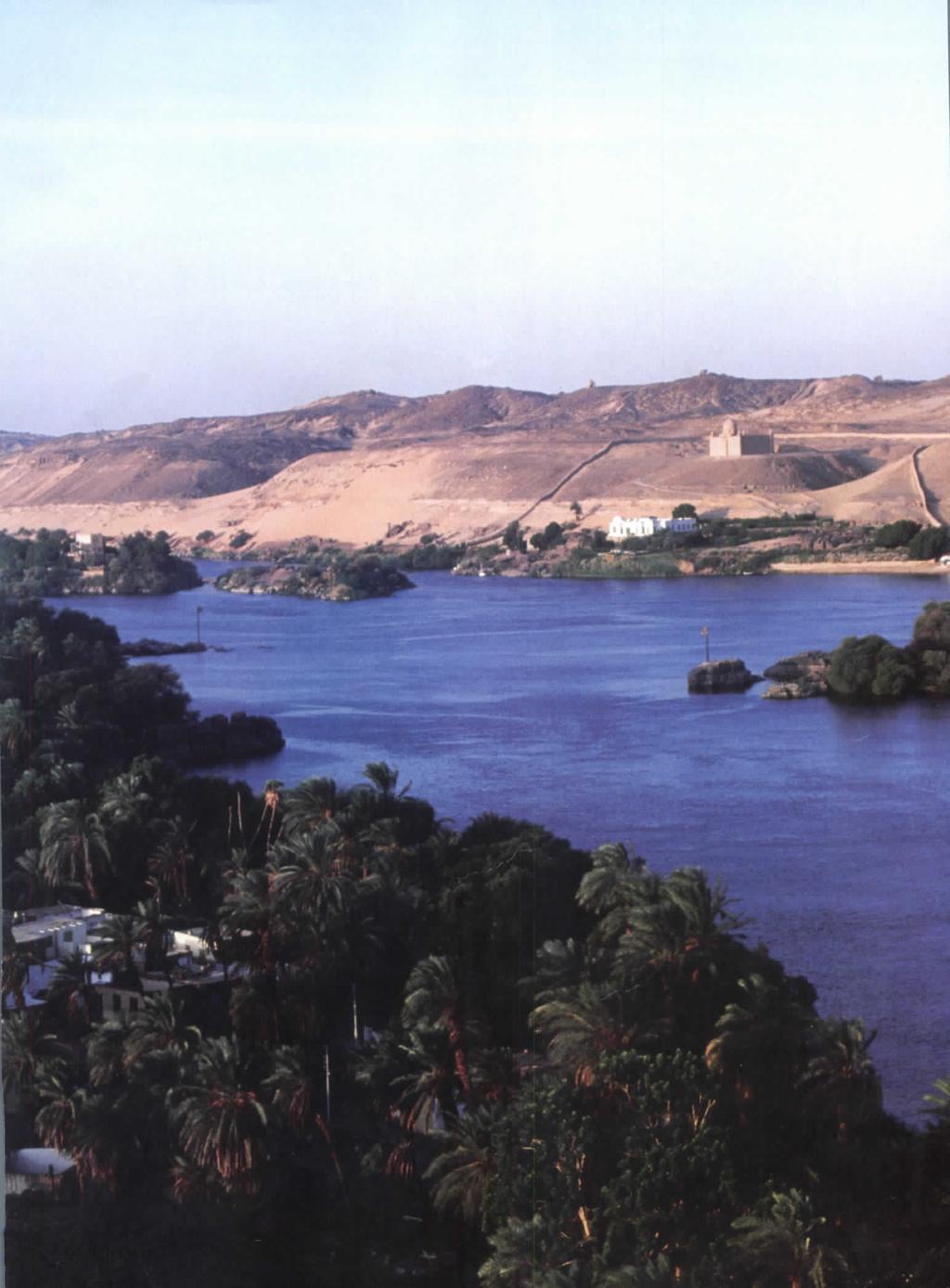
6 Vegetation A third environmental factor was vegetation, or plant life. There are many kinds of vegetation, such as trees, bushes, flowers, grass, and reeds. The crops people grow are also a type of vegetation. Many physical features affect vegetation. Mild weather, regular rain, and fresh water are good for plant life. The areas around rivers and lakes are usually green and lush. Mountains are often covered with thick groves of trees. Deserts, being dry and hot, have very little vegetation. The vegetation in an area influenced early human settlement in several ways. Most important, plants were a source of food. People ate both wild plants and crops they had planted. But vegetation had other uses as well. People learned to make many useful products out of plants, including medicine, baskets, rope, tools, and even paper. Trees provided shade from the hot sun. And plants and flowers helped to make a place beautiful. Water, topography, and vegetation were important wherever people settled in the ancient world. Let's look now at how these environmental factors influenced the early settlements of Egypt, Kush, and Canaan. Can you identify three environmental factors in this photograph? Why might they be important to the people living in this place? - i Geography and the Early Settlement of Egypt. Kush, and Canaan 67

7 Africa's Nile River is the longest river in the world. It is more than 4,100 miles long and flows from south to north, draining into the Mediterranean Sea. delta an area of sediment deposited at the mouth of a river 7.3 Environmental Factors and the Early Settlement of Egypt and Kush The Egyptians and Kushites both settled near the Nile River. The Egyptians lived along the northern part of the river. The Kushites lived to the south. Why did settlements in these areas cluster around the Nile? Let's look at the physical features of Egypt and Kush and then see how environmental factors favored settlement near the Nile. Key Physical Features of Ancient Egypt and Kush kilornelers M fttn?n,i n i'd n St'.i Physical Features of Egypt and Kush The most important physical feature in ancient Egypt and Kush was the Nile River. Flowing north from deep in Africa, the Nile created a long, fertile valley that ended in a marshy delta by the Mediterranean Sea. The Nile River valley was surrounded by the Libyan Desert, the Arabian Desert, and the Nubian Desert. These sandy deserts were extremely hot and dry. Most people avoided them, yet the deserts did play one important role in the settlement of Egypt and Kush. They formed a natural barrier that helped protect people living in the Nile River valley. The deserts did not support large settlements, and few invaders wanted to cross them. On the north, Egypt was bordered by the Mediterranean Sea. Settlers could not drink its sparkling salt water, but the sea was rich in fish and other kinds of life. It was also a waterway that linked ancient Egypt to other civilizations. To the east of Egypt and Kush was a long, thin channel of very salty water called the Red Sea. The climate in this area was hot and dry. Much of the land near the Red Sea was desert. 68 Chapter 7

8 Environmental Factors and Human Settlement in Egypt and Kush Environmental factors in ancient Egypt and Kush greatly favored settlement near the Nile River. Most important, the Nile was a source of fresh water in an area that was mostly desert. The lack of water in the deserts made them useless for farming. But in the Nile River valley, the river provided natural irrigation and fertilization. Every summer, the river overflowed its banks. The floodwaters soaked the dry ground. After several weeks, the waters went down. A thin ribbon of silt (rich soil) was left behind. This soil was perfect for farming. Where there is fresh water, there are usually fish to catch and animals to hunt. The abundant wildlife in the Nile region included fish, ducks, geese, hippos, crocodiles, giraffes, and ostriches. The topography of the river valley also encouraged human settlement. In the south, parts of the Nile ran through narrow valleys and hills. But there were also wide areas of flat land around deep bends in the river. These flat areas were good for farming. In the north, wide plains were watered by the Nile's annual flooding. Vegetation was rare in the dry deserts, but it was plentiful in the Nile River valley. Useful plants included reeds and a tough water plant called papyrus. People wove reeds into baskets and roofs for their huts. They used papyrus to make rope and paper. And the rich farmland made it easy to grow crops like wheat and barley. fertilization the process of adding fertilizer, or plant food, to soil papyrus a tough water plant used to make paper and rope in ancient times Deserts are natural barriers against invaders. Would you want to walk for days across this hot, dry desert to fight those who live on the other side? Geography and the Early Settlement of Egypt, Kush, and Canaan 69

9 7.4 Environmental Factors and the Early Settlement of Canaan Canaan, where the ancient Hebrews settled, was a diverse land. Canaan's physical features and environmental factors made settlement easier in some areas than in others. While parts of the Jordan River valley were lush, the area was not as fertile as the Nile River valley. Physical Features of Canaan Canaan's physical features included plains and valleys, hills and mountains, deserts, and bodies of water. In the west, coastal plains bordered the Mediterranean Sea. To the north, the Lebanon Mountains rose steeply from the coast. The southern part of this range gave way to the lower hills of Galilee. The Jordan River flowed down from a mountain range through the middle of Canaan, heading south through the Sea of Galilee to the Dead Sea. T h e land around the narrow river valley included hills, grassy slopes, and mountains. To the east was the hot, dry Syrian Desert. In southwestern Canaan was the Negev Desert. Rain soaked this area during the winter months, giving the Negev more water than most deserts. Key Physical Features of Ancient Canaan 50 miles, -I kilometers NEGEV DESERT LEBANON MOUNTAINS Dead Sea s SYRIAN DESERT Environmental Factors and Human Settlement in Canaan In Canaan, just as in Egypt and Kush, water was a key environmental factor. The wet, fertile plains near the Mediterranean Sea were farmed in very ancient times. The Mediterranean also allowed traders from many lands to visit Canaan. Other bodies of water played a role in the settlement of Canaan. The Sea of Galilee was actually a freshwater lake. It had plentiful fish, and fertile land was nearby. Another large lake, the Dead Sea, was so salty that nothing grew in it, not even plants. The area near the Dead Sea was hot, dry, and not very good for farming. The most important source of fresh water was the Jordan River. People hunted, fished, and farmed along its banks. But unlike the Nile, the Jordan did not flood regularly, so its valley was not as fertile as the Nile's. 70 Chapter 7

10 1* * /» Canaan's varied topography greatly influenced patterns of settlement. Farmers found it easiest to live in the coastal plains and near the Jordan River. But in many areas, the hilly land and dry soil made growing crops difficult. As a result, many people, including the aneient Hebrews, became herders rather than farmers. Herders tended flocks of sheep, goats, cattle, donkeys, and camels. Unlike farmers, herders were nomads, wandering from place to place in search of good land for their animals to graze. The mountains and deserts were the hardest areas to settle. Mountainous land was difficult to farm, and the deserts were too dry for fanning. Still, some people did settle in these areas. Nomads sometimes herded cattle and camels in the Negev and Syrian Deserts. In general, Canaan's hot, dry climate discouraged abundant plant life. Vegetation was most plentiful near the Jordan River. Some places had light forests. Others had only short, scrubby plants. Grasslands were common, though, and herders made good use of them to feed their animals. The Negev is not as dry as most deserts. After the winter rains, colorful flowers bloom there every spring. nomad a person who moves from place to place with no permanent home 7.5 Chapter Summary In this chapter, you learned about three environmental factors that influenced the settlement of ancient Egypt, Kush, and Canaan. In Egypt and Kush, most people farmed in the fertile Nile River valley. In Canaan, many people, including the ancient Hebrews, were nomads. They followed their herds in search of good grazing land. In the next chapter, you will learn more about ancient Egypt and meet some of its rulers. Geography and the Early Settlement of Egypt, Kush, and Canaan 71
Chapter 7 Geography and the Early Settlement of Egypt, Kush, and Canaan
 Chapter 7 Geography and the Early Settlement of Egypt, Kush, and Canaan How did geography affect early settlement in Egypt, Kush, and Canaan? Section 7.1 - Introduction RF/NASA//Corbis This satellite photograph
Chapter 7. Geography and the Early Settlement of Egypt, Kush, and Canaan
 Chapter 7 Geography and the Early Settlement of Egypt, Kush, and Canaan Chapter 7 Geography and the Early Settlement of Egypt, Kush, and Canaan How did geography affect early in Egypt Kush, and Canaan?
Chapter 7: The Geography and Settlement of Egypt, Kush, and Canaan
 Chapter 7: The Geography and Settlement of Egypt, Kush, and Canaan Learning Target: I can explain how geography affected early settlement in Egypt, Kush, and Canaan. Ancient Egypt and the Middle East Can
6th Grade Social Studies Chapter 7: The Geography and Early Settlement of Egypt, Kush and Canaan
 I. Introduction (7.1) A. Egyptians settled along the Nile River, in the NE corner of Africa B. civilization lasted from around 3100 B.C. to 350 C. E. C. Kushites settled to the south of Egypt, along the
Chapter 4. Ancient Egypt and Kush Section 1: Geography & Ancient Egypt
 Chapter 4 Ancient Egypt and Kush Section 1: Geography & Ancient Egypt The gift of the nile Geography played a key role in the development of the Egyptian civilization. The Nile River brought life to Egypt.
Ancient Egypt, Kush, and Israel
 G e o g r a p h y C h a l l e n g e Ancient Egypt, Kush, and Israel EUROPE ASIA ATLANTIC OCEAN AFRICA INDIAN OCEAN ATLANTIC OCEAN N W E S Ancient Egypt, about 1500 B.C.E. Kingdom of Kush, about 1500 B.C.E.
Ancient Egypt, Kush, and Israel
 500 1,000 miles T ER ES D N YA LIB 1 Geography and the Early Settlement of Egypt, Kush, and Canaan AFRICA NUBIAN DESERT ed 0 500 1,000 kilometers Sinusoidal (Sanson-Flamsteed) Projection S E ARABIAN PENINSULA
Ancient Egypt. Land of the Pharaohs
 Ancient Egypt Land of the Pharaohs CHAPTER 4 EGYPT SECTION 1: GEOGRAPHY AND EARLY EGYPT BIG IDEA The water, fertile soils, and protected setting of the Nile Valley allowed a great civilization to arise
The Nile Valley For use with pages 38 46
 READING ESSENTIALS AND STUDY GUIDE 2-1 The Nile Valley For use with pages 38 46 Key Terms cataract: spot of rapid waters in a river (page 39) delta: area of fertile soil at a river s end (page 39) papyrus:
Ancient River Valley Civilizations Egypt
 Ancient River Valley Civilizations Egypt Geography of Egypt The first civilization in Africa developed along the Nile River, in a place called Egypt. These humans were at first nomadic, also known as hunter-gatherers.
Ancient Egypt. Life Along the Nile River
 Ancient Egypt Life Along the Nile River 2018 Geography How Does Geography affect the way that people live? Geography- Where in the World? You are Here Streetsboro, Ohio United States of America Geography-
Passwords. Social Studies Vocabulary. Ancient Civilizations
 Passwords Social Studies Vocabulary Ancient Civilizations To the Student What is an epic? Is it bad if a tyrant takes over a country? What does an astronomer do? Passwords: Social Studies Vocabulary will
North Africa. Chapter 25. Chapter 25, Section
 Chapter 25, Section World Geography Chapter 25 North Africa Copyright 2003 by Pearson Education, Inc., publishing as Prentice Hall, Upper Saddle River, NJ. All rights reserved. Chapter 25, Section World
Chapter 4 : Ancient Egypt and Kush
 Chapter 4 : Ancient Egypt and Kush Chapter 4 Section 1 Geography and Ancient Egypt The Nile River is the most important thing in Egypt. The Nile is the longest river in the world. It stretches about 4000
Study Guide Chapter 5 Ancient Egypt and Kush
 Study Guide Chapter 5 Ancient Egypt and Kush 1) cataract: a waterfall or rapids in a river Key Vocabulary Terms: 9) bureaucrat: a government official 2) delta: a fan shaped are of silt near where a river
Rivers. Highlights of some of the World s Most Famous Rivers!
 Rivers Highlights of some of the World s Most Famous Rivers! Directions This Power Point presentation contains information about some of the most famous rivers in the world! Students should use this presentation
Unit 9 The Middle East SG 1 - Physical Geography, Population & Demographics
 Unit 9 The Middle East SG 1 - Physical Geography, Population & Demographics I. Physical Geography A. The Middle East includes southwestern Asia and North Africa. 1. The name is Eurocentric. Middle East
Geography of Ancient Greece Summary Sheet for Use in Assessment
 Geography of Ancient Greece Summary Sheet for Use in Assessment 1. At the same time that the Shang dynasty was ruling much of the Huang He River valley and the Egyptian pharaohs were building the New Kingdom
Lesson 1: The Lifeline of the Nile
 Lesson 1 Summary Lesson 1: The Lifeline of the Nile Use with pages 78 81. Vocabulary delta a triangular-shaped area of soil at the mouth of a river silt a mixture of soil and small rocks papyrus a plant
The Nile is the world s longest river. It is 4,160 miles long. It flows north and empties into the Mediterranean Sea
 The Nile is the world s longest river. It is 4,160 miles long It flows north and empties into the Mediterranean Sea Lower Egypt is at the Nile s mouth near the Mediterranean Sea. It is in Northern Egypt
Just how big is Africa?
 The United States China India The United Kingdom Portugal Spain France Belgium Germany The Netherlands Switzerland Italy Eastern Europe Japan 11.7 million sq. miles Just how big is Africa? Chapter 18 Section
Name Class Date. Ancient Egypt and Kush Section 1
 Name Class Date Ancient Egypt and Kush Section 1 MAIN IDEAS 1. Egypt was called the gift of the Nile because the Nile River gave life to the desert. 2. Civilization developed along the Nile after people
THE GEOGRAPHY OF THE NILE. Section 1
 THE GEOGRAPHY OF THE NILE Section 1 The Nile River is the world s longest river. It flows north from its sources in East Africa to the Mediterranean Sea for more than 4,000 miles. THE COURSE OF THE NILE
Essential Standards: WH.H.2 Analyze ancient civilization and empires in terms of their development, growth and lasting impact.
 Unit: Ancient Civilizations Topic: The Nile River Valley Essential Standards: WH.H.2 Analyze ancient civilization and empires in terms of their development, growth and lasting impact. Clarifying Objectives:
How the Nile River Led to Civilization in Ancient Egypt
 How the Nile River Led to Civilization in Ancient Egypt By USHistory.org, adapted by Newsela staff on 03.07.17 Word Count 786 Level 950L TOP: This photo, taken around 1915, shows the flooding of the Nile
Middle East Part I Notes
 Middle East Part I Notes What do we already know about the Middle East? What do we already know about the Middle East? Pre-Test 1. T/F- The U.S. is currently fighting a war in the Middle East. 2. Which
"The Nile River Valley"
 "The Nile River Valley" I. The Nile River Valley A. Geography of the Nile River Valley 1. flows for 4,000 miles a. from Central to the Mediterranean Sea b. sources include the Nile and the Nile 2. isolated
Egypt and the Nile River Valley System. SC Standards 6-1.3, 1.4, 1.5
 Egypt and the Nile River Valley System SC Standards 6-1.3, 1.4, 1.5 Where is Egypt? Egypt is on the continent of Africa. The River Nile runs through Egypt The capital of Egypt is Cairo Where is Egypt?
You Will Need: Your notebook Your textbook Your pencil
 You Will Need: Your notebook Your textbook Your pencil Today you will learn about the kingdoms of Kush and Aksum who developed advanced civilizations with large trading networks. Kush and Aksum Kush and
Welcome to Egypt! But before we talk about anything else, we have to talk about the most important thing in Egypt. (other than me) the Nile River.
 the Nile River.") Welcome to Egypt! Hi! My name is Sphinxy, your tour guide through the gift of the Nile. I ll show you all you need to know about the ancient kingdom of Egypt. (other than me) the Nile River. But before
Welcome to Egypt! Hi! My name is Sphinxy, your tour guide through the gift of the Nile. I ll show you all you need to know about the ancient kingdom of Egypt. (other than me) the Nile River. But before
Chapter 25 Geography and the Settlement of Greece. How did geography influence settlement and way of life in ancient Greece?
 Chapter 25 Geography and the Settlement of Greece 25.1 Introduction How did geography influence settlement and way of life in ancient Greece? Tal Naveh/Shutterstock The ancient Greeks learned to use the
Chapter 17. North Africa, Southwest Asia and Central Asia
 Chapter 17 North Africa, Southwest Asia and Central Asia Chapter Objectives Describe the major landforms and natural resources of North Africa, Southwest Asia, and Central Asia. Discuss the climate and
STUDY GUIDE. The Land. Chapter 17, Section 1. There are frequent earthquakes in the region. Petroleum is a major export in the region.
 For use with textbook pages 421 426. The Land Terms to Know alluvial soil A rich soil made up of sand and mud deposited by flowing water (page 423) wadi A streambed that remains dry until a heavy rain
Babylon. Ancient Cities by the River Lesson 5 page 1 of 6. Code of Hammurabi monument. E u p h. T i g r i s. r a t e s. Babylon, Mesopotamia
 Ancient Cities by the iver Lesson 5 page 1 of 6 1700s BCE, and established the importance of the city for the region He was responsible for a code of laws/decrees to reestablish justice in the land His
General Introduction to Ancient Egypt
 Name Date Period General Introduction to Ancient Egypt The Geography of the Nile The Nile flows north from East Africa to the Mediterranean Sea. Along the way there are rough, rocky areas called cataracts.
Ancient Egypt: an Overview
 Ancient Egypt: an Overview Timeline Old Kingdom Middle Kingdom 2650 BC 2134 BC 2125 BC 1550 BC New Kingdom 1550 BC 1295 BC http://www.thebanmappingproject.com/resources/timeline.html 1 Three Kingdoms of
1: The Nile River Valley
 1: The Nile River Valley In Nubia and Egypt, the Nile flows through the Sahara, a vast desert that stretches across most of northern Africa. Before reaching Egypt, the river in ancient times roared through
Name: Period: Date: Mediterranean Sea , '13"N 18 48'30"E. Nile River , '14.06"N 31 26'27.
 Name: : Date: Directions: Label the items in this column on the map. Mediterranean Sea 35.603719, 18.808594 35 36'13"N 18 48'30"E Nile River 26.853906, 3440919 26 51'14.06"N 31 26'27.31"E River Current
 Unifying Egypt (p. 85) Ancient Egypt was divided into two parts Upper Egypt and Lower Egypt. One famous legend tells of the king of Upper Egypt, whose name was Menes. He defeated the king of Lower Egypt
Geography (cont) Sorghum, rice, millet, rice, wheat and corn grown on savannahs. Not just one big plain though mountainous and swampy areas too
 Sorghum, rice, millet, rice, wheat and corn grown on savannahs. Not just one big plain though mountainous and swampy areas too") Geography & Society in Africa: 500 BCE-900 CE Geography Around 5000 miles wide and long Various climates, jungles, snow-capped mountains, deserts and rain-soaked areas. 40% desert - largely uninhabitable
Geography & Society in Africa: 500 BCE-900 CE Geography Around 5000 miles wide and long Various climates, jungles, snow-capped mountains, deserts and rain-soaked areas. 40% desert - largely uninhabitable
Indicate whether the statement is true or false.
 Indicate whether the statement is true or false. 1. Savannas are fertile marshes. 2. The New Kingdom pharaoh Amenhotep was successful in establishing a new religion based on the worship of Aton, the sun
Ancient Egypt. Nicknamed The Gift of the Nile
 Ancient Egypt Nicknamed The Gift of the Nile Egypt was first settled about 5000 B.C. (7000 years ago) by nomads Egyptian Civilization developed because of the Nile River Egyptian Geography located in the
How the Nile River Led to Civilization in Ancient Egypt
 How the Nile River Led to Civilization in Ancient Egypt By USHistory.org on 03.07.17 Word Count 1,108 Level MAX TOP: This photo, taken around 1915, shows the flooding of the Nile River, which happens each
Egypt (The Nile River Valley)
") 2 nd Quarter Civilizations Mesopotamia (The Tigris & Euphrates) Egypt (The Nile River Valley) India (The Indus River) China (The Yellow River) 1 River Valley Civilizations 2 3 2 nd Quarter 2017 ISN Table
2 nd Quarter Civilizations Mesopotamia (The Tigris & Euphrates) Egypt (The Nile River Valley) India (The Indus River) China (The Yellow River) 1 River Valley Civilizations 2 3 2 nd Quarter 2017 ISN Table
So130 Week 02 #13-63 #13. What is the Fertile Crescent a reference to?
 Week 02 STUDY GUIDE QUESTIONS #13-63 1 #13 What is the Fertile Crescent a reference to? A Band of Land where conditions favored the establishment of early agricultural settlements. 2 1 The Fertile Crescent
Brain Wrinkles. Africa: The impact of location, climate, & physical characteristics on where people live, the type of work they do, & how they travel
 Africa: The impact of location, climate, & physical characteristics on where people live, the type of work they do, & how they travel STANDARDS: SS7G3 The student will explain the impact of location, climate,
All of this week s homework is intended to help you get to know more about the country of Sudan, where Kek is from in Home of the Brave.
 Name: Week 7 Homework All of this week s homework is intended to help you get to know more about the country of Sudan, where Kek is from in Home of the Brave. On the map above, do the following things:
SS7G1 The student will locate selected features of Africa.
 Standards SS7G1 The student will locate selected features of Africa. a. Locate on a world and regional political-physical map: the Sahara, Sahel, savanna, tropical rain forest, Congo River, Niger River,
4th Grade Third 9 Weeks Test
 4th Grade Third 9 Weeks Test Multiple Choice Identify the choice that best completes the statement or answers the question. 1 A waterway for ships that is dug across land is called a. A port C river B
Development of African Agriculture
 Development of African Agriculture Sahara desert originally highly fertile region Western Sudan region nomadic herders, c. 9000 BCE Domestication of cattle c. 7500 BCE Later, cultivation of sorghum, yams,
STUDY GUIDE. The Land. Physical Features of Latin America. Chapter 8, Section 1. Terms to Know DRAWING FROM EXPERIENCE ORGANIZING YOUR THOUGHTS
 For use with textbook pages 193 198. The Land Terms to Know cordillera A mountain range that runs parallel to another mountain range (page 194) altiplano A high plain (page 194) escarpment A steep cliff
ì<(sk$m)=bdicij< +^-Ä-U-Ä-U
=bdicij< +^-Ä-U-Ä-U") Genre Comprehension Skill Text Features Science Content Nonfiction Compare and Contrast Captions Diagrams Rocks and Soil Labels Glossary Scott Foresman Science 3.7 ì
Genre Comprehension Skill Text Features Science Content Nonfiction Compare and Contrast Captions Diagrams Rocks and Soil Labels Glossary Scott Foresman Science 3.7 ì
Reading Informational Medford 549C Work Sample Effective February 2010 Informational Text Title:
 Reading Informational Medford 549C Work Sample Effective February 2010 Informational Text Title: Geography and the Settlement of Greece Reading Work Sample Assessment Middle School Geography and the Settlement
Egyptian Civilization (3100 B.C-332 B.C.)
") Egyptian Civilization (3100 B.C-332 B.C.) Ancient Egypt -a land of mysteries. No other civilization has so captured the imagination of scholars and public in general. Mystery surrounds its origins, its
Egyptian Civilization (3100 B.C-332 B.C.) Ancient Egypt -a land of mysteries. No other civilization has so captured the imagination of scholars and public in general. Mystery surrounds its origins, its
Chapter 20. The Physical Geography of Africa South of the Sahara
 Chapter 20 The Physical Geography of Africa South of the Sahara Chapter Objectives Identify the major landforms, water systems, and natural resources of Africa south of the Sahara. Describe the relationship
1 o f 5. Name Period. Parent Signature
 Name Period Parent Signature DIRECTIONS: Write the definition on the line next to each of the vocabulary terms below. Then in the box, draw a picture that will help you remember the word and definition.
Unit 6 vocabulary. Serengeti Plain
 basin Nile River rift valley Mount Kilimanjaro escarpment Sahara aquifer oasis Serengeti Plain canopy Niger delta Sahel the world s longest river, flowing more than 4,000 miles through Uganda and Sudan
Ancient Egypt & Judaism
 Ancient Egypt & Judaism OUTCOME: GEOGRAPHY, CULTURE, & THE OLD KINGDOM 1 CONSTRUCTIVE RESPONSE QUESTIONS 1. Summarize the geography of Egypt and its surrounding lands: 2. Describe Egyptian culture including
Chapter 16 ~ Eastern Mediterranean
 Chapter 16 ~ Eastern Mediterranean Physical Geography of the Eastern Mediterranean Landforms This area is known as the Levant and includes Syria, Jordan, Lebanon, Israel, and the Palestinian territories.
Chapter 16 ~ Eastern Mediterranean
 Chapter 16 ~ Eastern Mediterranean Physical Geography of the Eastern Mediterranean Landforms This area is known as the Levant and includes Syria, Jordan, Lebanon, Israel, and the Palestinian territories.
If the Nile shines, the Earth is joyous
 If the Nile shines, the Earth is joyous Every stomach is full of rejoicing, Every spine is happy, Every jawbone crushes its food, --Hymn to the Nile What is the tone of this hymn? What does the Nile shines
Chapter 10: The Kingdom of Kush
 Chapter 10: The Kingdom of Kush Learning Target: I can explain how location influenced the Kingdom of Kush. Introduction The African kingdom of Kush was located on the Nile River, to the south of Egypt.
A: Pre-reading Vocabulary
 - 1 - In this text you are going to read about Egypt and the Egyptian people. There are some words in this text that you won t see very often when you are reading but are important for this text. These
ANCIENT EGYPT STUDY GUIDE REVIEW
 ANCIENT EGYPT STUDY GUIDE REVIEW LOCATION/NILE RIVER EGYPT IS LOCATED ON THE CONTINENT OF AFRICA. NILE RIVER LONGEST RIVER IN THE WORLD. 4,000 MILES LONG BEGINS IN CENTRAL AFRICA & RUNS NORTH THROUGH EGYPT
AFRICAN CIVILIZATION. The Kushite Kingdom in Upper Egypt and the Sudan
 AFRICAN CIVILIZATION The Kushite Kingdom in Upper Egypt and the Sudan The Kingdom of Kush The civilization of Kush thrived from about 2000 B.C.E. to 350 C.E. Kush and Egypt had a close relationship throughout
North Africa and Southwest Asia. Economic Geography
 North Africa and Southwest Asia Economic Geography Natural Resources Oil is the major resource in this region. Many countries in this region are members of OPEC (Organization of Petroleum Exporting Countries).
netw rks Where in the world? When did it happen? Ancient Egypt and Kush Lesson 1 The Nile River ESSENTIAL QUESTION Terms to Know GUIDING QUESTIONS
 NAME DATE CLASS Lesson 1 The Nile River Terms to Know ESSENTIAL QUESTION cataracts dangerous, fast-moving waters delta a fan-shaped area of marshy land near where a river flows into the sea shadoof a bucket
Chapter 10 The Kingdom of Kush. In what ways did location influence the history of Kush?
 Chapter 10 The Kingdom of Kush In what ways did location influence the history of Kush? 10.1. Introduction Kushites built pyramids and temples. The pyramids shown here are south of Egypt, in the present-day
Ancient Greece GREECE UNIT 5 GEOGRAPHY CHALLENGE. 1 Unit 5 Geography Challenge miles. Lambert Azimuthal Equal-Area Projection
 W N S E UNIT 5 GEOGRAPHY CHALLENGE Ancient Greece 0 250 500 miles 0 250 500 kilometers Lambert Azimuthal Equal-Area Projection GREECE 1 Unit 5 Geography Challenge UNIT 5 GEOGRAPHY CHALLENGE Geography Skills
The Ancient Egyptians
 The Ancient Egyptians Geography of Ancient Egypt Religion In Ancient Egypt Ancient Egyptian Society The Geography of Ancient Egypt Nile River Giver of Life Longest river in the world @ 4200 miles Protected
Key Geographic Features
 DUE 12/6/18 Name: Lesson One: Egypt Geography 6.15 On a historical map locate the Mediterranean and Red Seas, the Nile River and Delta, and the areas of ancient Nubia and Egypt. Identify the locations
5. What do you notice about population distribution and settlement location in Ancient Egypt? List three or four reasons for this.
 Document A Source: Map created from various sources. Egypt circa 1500 BCE Mediterranean Sea 1. The Nile is the world's longest river, 4,160 miles. Consider the southern boundary of Ancient Egypt to be
Friday, November 10, 2017
 Friday, November 10, 2017 Andes and Midlatitude Countries Objective: Summarize the main physical features and regions of the Southern Cone. Identify and locate the urban centers and understand the pattern
The River Nile. Use an atlas to draw on the River Nile. Colour the countries that use the River Nile.
 The River Nile Use an atlas to draw on the River Nile. Colour the countries that use the River Nile. http://alabamamaps.ua.edu/contemporarymaps/world/africa/index.html The start of the River Nile is in
Module 1 Educator s Guide: Representative Discussion Points Investigation 3
 Module 1 Educator s Guide: Representative Discussion Points Investigation 3 Ethiopia and Eritrea Our combined population is 59,578,171 people. We have just emerged from a long period of civil war and famine.
Chapter Test. History of Ancient Egypt
 Name Class Date MULTIPLE CHOICE Read each statement or question. On the lines below write the letter of the best answer. 1. Which of the following best describes why Herodotus called Egypt the gift of
Chapter 5 Lesson 1 Notes: The Gift of the Nile
 Chapter 5 Lesson 1 Notes: The Gift of the Nile Geography of Ancient Egypt The Longest River The River is 4,160 miles long - is the world s longest river - begins near equator in Africa - flows north to
Varied Lands and Varied Resources Chapter 9 Lesson 1
 Varied Lands and Varied Resources Chapter 9 Lesson 1 16 independent countries make up region of Europe From in north to Balkan Peninsula in south Eastern Europe four separate sub regions Western Balkans
Introduction to Africa
 Introduction to Africa Did you know? Africa has more countries than any other continent. The Sahara is a desert that is the size of the U.S. It s the world's largest desert. Most of the world s gold and
GEOGRAPHY AND HISTORY
 GEOGRAPHY AND HISTORY YEAR 1, PART 1 www.vicensvives.es Contents 01 Our planet Earth 02 The representation of the Earth: maps 03 The Earth s relief 04 Rivers and seas 05 Weather and climate 06 Climates
Unit Two. Water on Earth
 CONTENTS Unit One People and Culture Lesson One: Family Traditions Lesson Two: Holidays and Celebrations Lesson Three: Taking Care of My Teeth Lesson Four: I Want to Be a Vet Lesson Five: Dairy Farmer
Shaded relief map of Egypt
 PHYSICAL LANDSCAPES OF ANCIENT EGYPT EGYPT: GIFT OF THE NILE - HERODOTUS MODIS (Moderate Resolution Imaging Spectroradiometer) image of the Nile River Valley, from NASA. Dr. John Paul Stimac Honors College
7/8 World History. Week 10. The Late Bronze Age
 7/8 World History Week 10 The Late Bronze Age Monday Do Now What do you know about Greece? Objectives Students will identify the main idea and key points in the notes. Students will compare/contrast Greece
UNIT 5 AFRICA PHYSICAL GEOGRAPHY SG 1 - PART II
 UNIT 5 AFRICA PHYSICAL GEOGRAPHY SG 1 - PART II III. CLIMATE & VEGETATION A. The four main climate zones are tropical wet, tropical wet/dry (split into monsoon & savanna), semiarid, and arid. Other climate
The Rise of Civilization. Ancient Egypt
 The Rise of Civilization Ancient Egypt Geography The Egyptian civilization was located in Egypt in North Africa. The Egyptian empire was located on the lower deltas of the Nile River. The Egyptians lived
Region 1 Piney Woods
 Region 1 Piney Woods Piney Woods 1. This ecoregion is found in East Texas. 2. Climate: average annual rainfall of 36 to 50 inches is fairly uniformly distributed throughout the year, and humidity and temperatures
Chapter 21: EAST AFRICA
 Chapter 21: EAST AFRICA Physical Geography of East Africa Landforms East Africa is a diverse landscape of different plains, volcanic mountains, and plateaus cut by a large valley and marked by many rivers
Good morning! You need: both sheets from yesterday! Write HW in agenda: BRING IN CANS. College day tomorrow: Wear college shirts and hats!
 Good morning! You need: both sheets from yesterday! Write HW in agenda: BRING IN CANS College day tomorrow: Wear college shirts and hats! Ancient Greece BIG IDEA: Greece s geography and closeness to seas
Vocabulary Words. predict inundation deity afterlife. mummy cataract nation-state dynasty
 The Gift of Nile Vocabulary Words predict inundation deity afterlife mummy cataract nation-state dynasty Predict Predict: To tell ahead of time what will happen. Inundation Inundation; Annual flooding
GOLDEN AGE A new dynasty of pharaohs came to power Moved the capital to Thebes Started a period of peace and order called The Middle Kingdom Lasted
 5.3 GOLDEN AGE A new dynasty of pharaohs came to power Moved the capital to Thebes Started a period of peace and order called The Middle Kingdom Lasted from 2055 BCE to 1650 BCE CONQUESTS Controlled
a. waterfall b. to unite d. free
 Vrdulap Preview Vocabulary Preview Directions: Match each word on the left with its definition on the right. Write the letter of the definition on the line beside each word. You may use your textbook.
Aim: How did geography impact the development of classical Greece?
 Aim: How did geography impact the development of classical Greece? Do Now: Making Predictions- View ALL images on your worksheet/screen and answer the following questions: 1.List the different types of
Ancient Egypt & Kush. I. Egypt Under the Pharaohs
 Ancient Egypt & Kush I. Egypt Under the Pharaohs A. The Nile 1. longest river in the world (4,100 miles) 2. flows north into Mediterranean Sea 3. Upper Nile is in South 4. Lower Nile is in North 5. Flooded
Desert Protection. Protected on four sides. 1. Desert to the East & West 2. Cataracts to the South 3. Marshy Delta to North
 EGYPTIAN PANELS Desert Protection Protected on four sides 1. Desert to the East & West 2. Cataracts to the South 3. Marshy Delta to North One of the most stable civilizations in history ANCIENT EGYPT AREAS
People of the Nile 5. Lesson Objectives. Core Content Objectives. Language Arts Objectives
 People of the Nile 5 Lesson Objectives Core Content Objectives Students will: Locate Egypt on a world map or globe and identify it as a part of Africa Explain the importance of the Nile River and how its
Latin America. Chapter 9 Physical Geography
 Latin America Chapter 9 Physical Geography Latin American Regions Middle America includes Mexico and the Central American countries The Caribbean Islands South America Mexico Landforms Sierra Madre Oriental
Ancient Greece. Teachers Curriculum Institute Geography and the Settlement of Greece 1
 G e o g r a p h y C h a l l e n g e Ancient Greece G R E E C E N W E S 0 250 500 miles 0 250 500 kilometers Lambert Azimuthal Equal-Area Projection Teachers Curriculum Institute Geography and the Settlement
STUDY GUIDE. The Land. Chapter 20, Section 1. The Land of Africa South of the Sahara. Landforms Water Systems Natural Resources.
 For use with textbook pages 499 504. The Land Terms to Know escarpment A steep, often jagged slope or cliff (page 500) cataract A towering waterfall (page 500) rift valley A large crack in the earth s
Life in Ancient Egypt
 Life in Ancient Egypt Rapid Fire- SGA Instructions! Groups will have 5 min to create a rapid fire SGA.! Using the information provided, you must say the highlighted words on your resource sheets! You must
Life in Ancient Egypt
 Life in Ancient Egypt Text: http://www.ancientegypt.co.uk/ Photos: Google Images (public domain) The civilization of ancient Egypt lasted for over three thousand years. During this time there were many