Chapter 16 ~ Eastern Mediterranean
|
|
|
- Gerald Hodge
- 6 years ago
- Views:
Transcription

1 Chapter 16 ~ Eastern Mediterranean
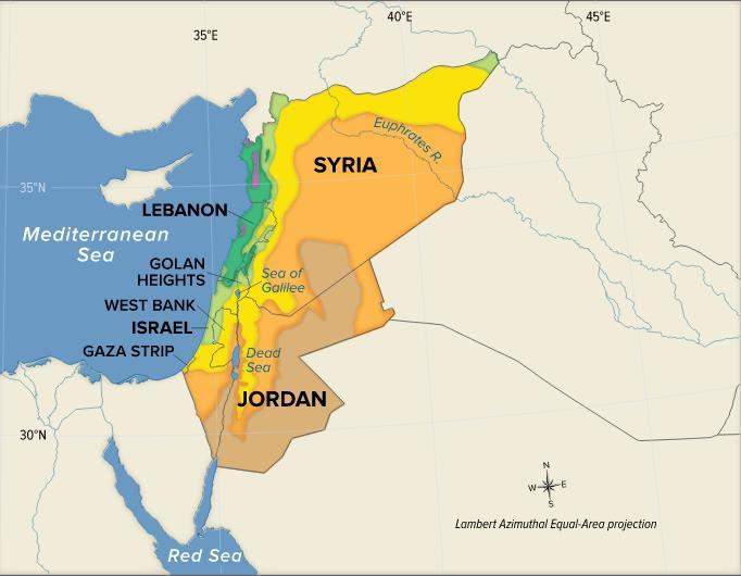
2 Physical Geography of the Eastern Mediterranean Landforms This area is known as the Levant and includes Syria, Jordan, Lebanon, Israel, and the Palestinian territories. The area is marked by mountains and deserts and has a generally temperate climate. The sparsely populated Anti-Lebanon mountain range runs along the border between Syria and Lebanon. The Syrian Desert is composed of gravel and used as a roadway.

3 the Levant

4 Anti-Lebanon Mountains form the majority of the border between Syria and Lebanon

5

6 Syrian Desert

7 v TURKEY SYRIA IRAQ JORDAN SAUDI ARABIA
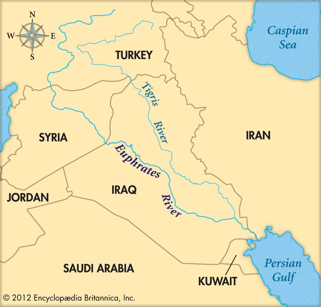
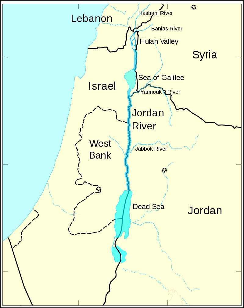
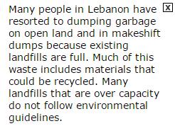
8 Physical Geography of the Eastern Mediterranean Water Systems The Euphrates River is the most important river in Syria and provides the entire country with water. Important for irrigation and agriculture, the Jordan River flows through all the countries in the subregion and provides a natural border between the West Bank and Jordan. The Gulf of Aqaba connects the subregion with the Red Sea and Indian Ocean.
9

10 Euphrates River eastern Syria
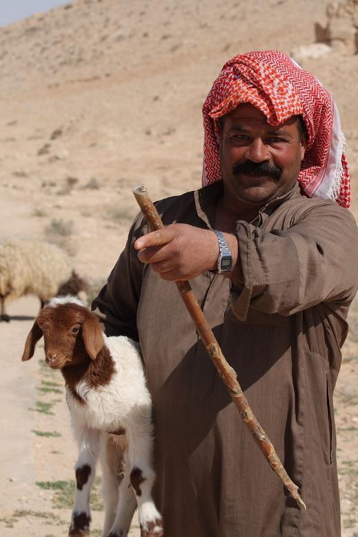
11

12 Jordan River

13 Sinai Peninsula

14 Gulf of Aqaba

15
16 Physical Geography of the Eastern Mediterranean Climate, Biomes, & Resources Rainfall is limited in the subregion, which consists of mostly semi-arid and arid climates. The coastal regions have a Mediterranean climate that supports agriculture, and a wide array of vegetation and wildlife. As one moves inland, the climate becomes humid subtropical, then shifts to semi-arid steppe and arid desert. Lumber and minerals are important natural resources in the subregion.
17
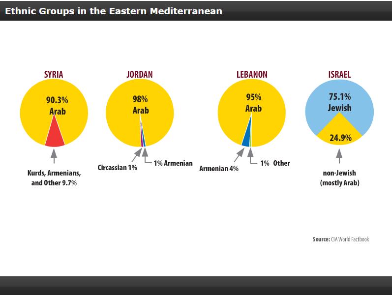
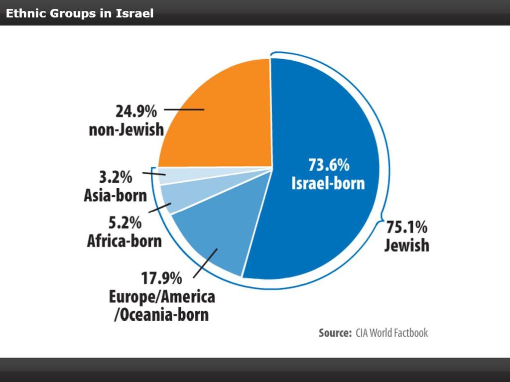
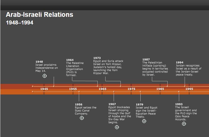
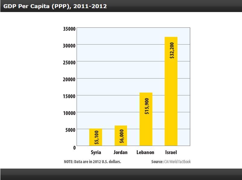
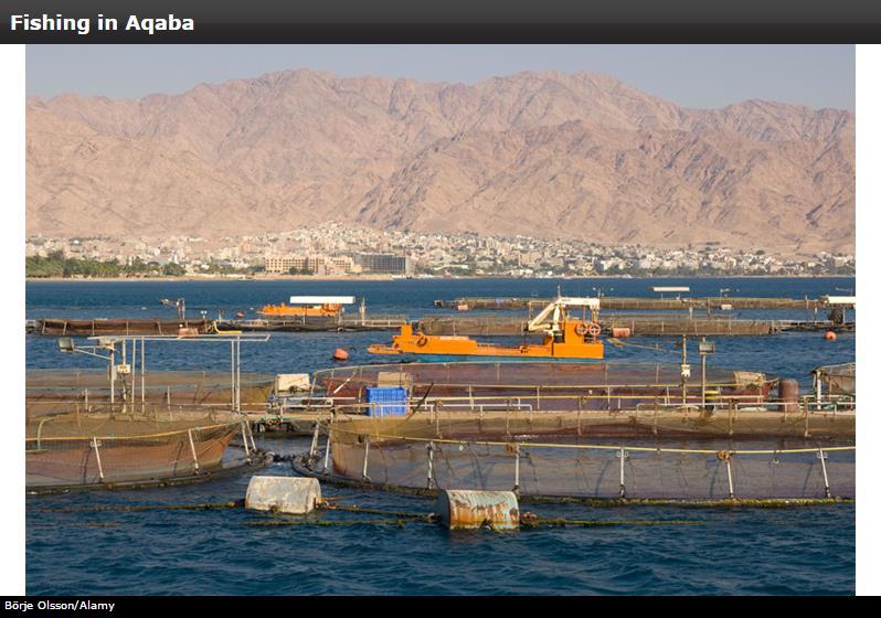
18 Human Geography of the Eastern Mediterranean Population Patterns The dry, desert climate causes most people to live along the coastal plains. Many ethnicities and religious sects reside in the subregion. Demographics have changed drastically in the past century, with Israel experiencing a large migration of Russian Jews and the displacement of Palestinians following the establishment of the Israeli state.
19
20
21
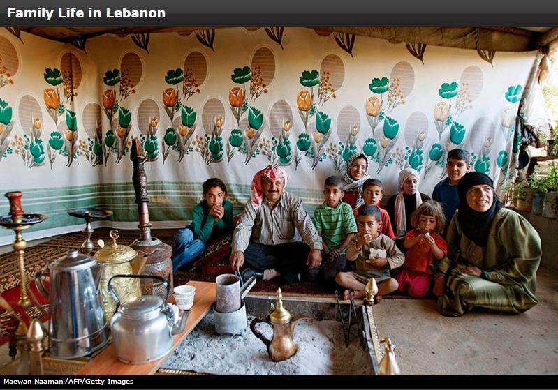
22 Human Geography of the Eastern Mediterranean Society & Culture Today Arabic is the primary language in the subregion, with Hebrew also spoken in Israel. Quality of education and health care varies widely from country to country. Family life usually includes the extended family and often includes religious worship. In Israel, women generally enjoy equal rights, while in Arabic countries, women s rights vary greatly.

23
24
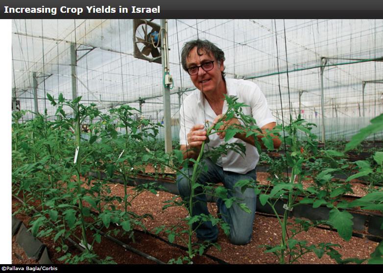
25 Human Geography of the Eastern Mediterranean Economic Activities Economic growth is dependent on agriculture, small deposits of minerals, and manufacturing. Service industries play a significant role in the subregion s economy, as does tourism, although it can be negatively affected by conflicts and political instability. Water transportation is vital to the area, with the Strait of Tirān linking the Gulf of Aqaba to the Red Sea.
26
27
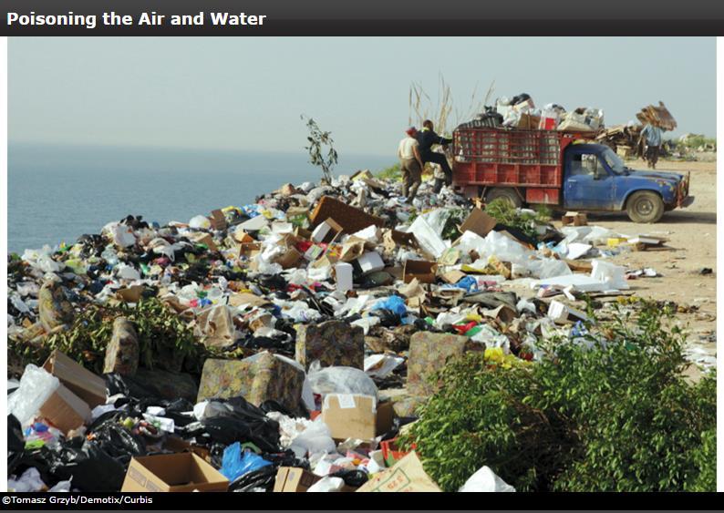
28 People and Their Environment: the Eastern Mediterranean Managing Resources Overfishing, contamination, a rise in sea surface temperatures, and the introduction of invasive species have caused environmental damage to the Mediterranean Sea. High levels of urbanization and immigration have increased air pollution, which is exacerbated during heat waves. Bird populations in the subregion also face a serious threat from illegal hunting.

29
30
31
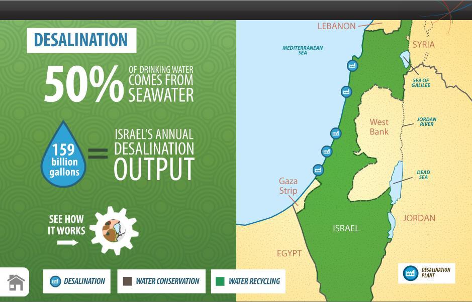
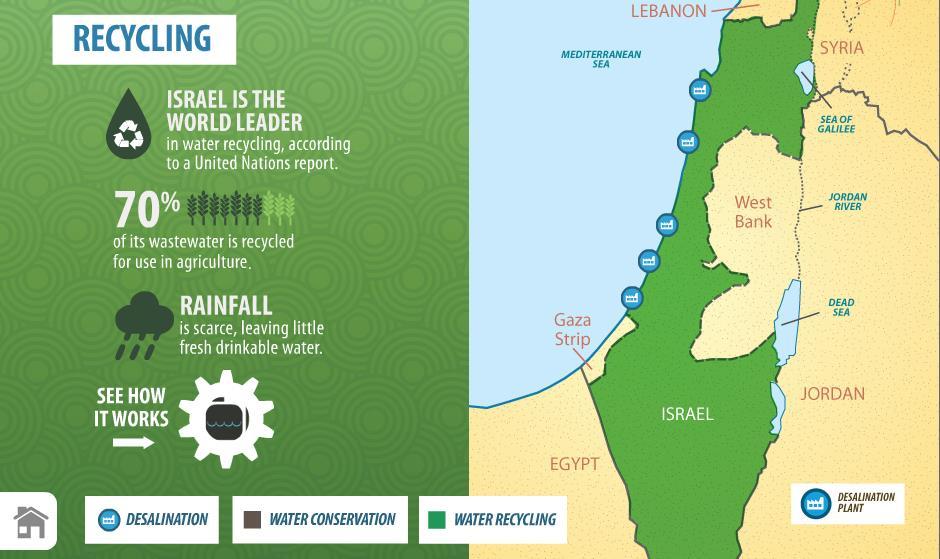
32 People and Their Environment: the Eastern Mediterranean Human Impact Long-term deforestation and desertification, or the process in which arable land becomes desert, are two major problems in the subregion. Large mammals have become endangered as a result of the destruction of their habitats. Despite using desalination plants and water recycling programs, Israel will need to find new sources of fresh water as its agricultural sector grows.
33
34
35
36 People and Their Environment: the Eastern Mediterranean Addressing the Issues Legislation such as the Israeli Clean Air Law has attempted to address environmental issues. International organizations have been trying to encourage governments to take environmental projects seriously and increase protective legislation. More work is needed to help alleviate air and water pollution and to stop overfishing.
Chapter 16 ~ Eastern Mediterranean
 Chapter 16 ~ Eastern Mediterranean Physical Geography of the Eastern Mediterranean Landforms This area is known as the Levant and includes Syria, Jordan, Lebanon, Israel, and the Palestinian territories.
Chapter 21: EAST AFRICA
 Chapter 21: EAST AFRICA Physical Geography of East Africa Landforms East Africa is a diverse landscape of different plains, volcanic mountains, and plateaus cut by a large valley and marked by many rivers
Unit 9 The Middle East SG 1 - Physical Geography, Population & Demographics
 Unit 9 The Middle East SG 1 - Physical Geography, Population & Demographics I. Physical Geography A. The Middle East includes southwestern Asia and North Africa. 1. The name is Eurocentric. Middle East
Chapter 17. North Africa, Southwest Asia and Central Asia
 Chapter 17 North Africa, Southwest Asia and Central Asia Chapter Objectives Describe the major landforms and natural resources of North Africa, Southwest Asia, and Central Asia. Discuss the climate and
North Africa and Southwest Asia. Economic Geography
 North Africa and Southwest Asia Economic Geography Natural Resources Oil is the major resource in this region. Many countries in this region are members of OPEC (Organization of Petroleum Exporting Countries).
Portuguese Language - Fostering National Unity
 Geography Brazil Brazil Portuguese Language - Fostering National Unity 11 dialects of Portuguese Influenced by Amerindian and African languages, creating differences between Portuguese spoken in Brazil
CHAPTER 12. South America. Section 1: Natural Environments Section 2: History and Culture Section 3: South America Today. HOLT World Geography
 CHAPTER 12 South America Section 1: Natural Environments Section 2: History and Culture Section 3: South America 1 Section 1 Natural Environments Objectives: What are the major landforms and rivers of
Brief Description of Northern the West Bank, Palestine Prepared by: Dr. Ahmed Ghodieh Department of Geography An-Najah National University Nablus,
 Brief Description of Northern the West Bank, Palestine Prepared by: Dr. Ahmed Ghodieh Department of Geography An-Najah National University Nablus, Palestine Brief Description of Northern the West Bank
Physical characteristics and biomes:
 Physical characteristics and biomes: Sahel region, bordering Sahara Characteristics Area suffers from lack of rainfall, over grazing, which causes loss of vegetation and loss of inhabitable areas causing
Physical Geography of Europe. Chapters 13-18
 Physical Geography of Europe Chapters 13-18 The British Isles Archipelago made of 6000+ small islands Temperate climate Largest body of fresh water is Loch Ness Mostly rolling hills and large flat lands
STUDY GUIDE. The Land. Chapter 17, Section 1. There are frequent earthquakes in the region. Petroleum is a major export in the region.
 For use with textbook pages 421 426. The Land Terms to Know alluvial soil A rich soil made up of sand and mud deposited by flowing water (page 423) wadi A streambed that remains dry until a heavy rain
6th Grade Social Studies Chapter 7: The Geography and Early Settlement of Egypt, Kush and Canaan
 I. Introduction (7.1) A. Egyptians settled along the Nile River, in the NE corner of Africa B. civilization lasted from around 3100 B.C. to 350 C. E. C. Kushites settled to the south of Egypt, along the
سبل تفعيل تنفيذ ا تفاقية الا راضى الرطبة فى المنطقة العربية
 CONVENTION ON WETLANDS "RAMSAR" AND THE ARAB REGION سبل تفعيل تنفيذ ا تفاقية الا راضى الرطبة فى المنطقة العربية "رامسار" National Institute of Oceanography and Fisheries WETLANDS SERVICES AND PRODUCTS
1. What are the problems with tourism in Jordan? 2. How is sustainable tourism being encouraged?
 Jordan 1. What are the problems with tourism in Jordan? 2. How is sustainable tourism being encouraged? TAB 1 QUESTION - What are the problems with tourism in Jordan? Before looking into tourism in Jordan
Southern Africa. Countries, Geography, & Climate
 Countries, Geography, & Climate The Southern African region consists of the following countries: Angola Zambia Malawi Mozambique Zimbabwe Botswana Namibia Swaziland Lesotho South Africa Comoros Madagascar
Location, Climate, & Natural Resources
 Location, Climate, & Natural Resources UK is a country of islands off the coast of mainland Europe. It consists of England, Northern Ireland, Scotland, & Wales. UK s location makes it a HUB for trade.
Location, Climate, & Natural Resources Brain Wrinkles
 Location, Climate, & Natural Resources Standards SS6G10 The student will explain the impact of location, climate, natural resources, and population distribution on Europe. a. Compare how the location,
Chapter 7 Geography and the Early Settlement of Egypt, Kush, and Canaan
 Chapter 7 Geography and the Early Settlement of Egypt, Kush, and Canaan How did geography affect early settlement in Egypt, Kush, and Canaan? Section 7.1 - Introduction RF/NASA//Corbis This satellite photograph
UNIT 5 AFRICA PHYSICAL GEOGRAPHY SG 1 - PART II
 UNIT 5 AFRICA PHYSICAL GEOGRAPHY SG 1 - PART II III. CLIMATE & VEGETATION A. The four main climate zones are tropical wet, tropical wet/dry (split into monsoon & savanna), semiarid, and arid. Other climate
Chapter Objectives. Describe the dominant landforms and natural resources of Southeast Asia. Discuss Southeast Asia s climate and vegetation.
 Chapter Objectives Describe the dominant landforms and natural resources of Southeast Asia. Discuss Southeast Asia s climate and vegetation. The Land Section 1 Objectives Describe how tectonic plates and
SS7G1 The student will locate selected features of Africa.
 Standards SS7G1 The student will locate selected features of Africa. a. Locate on a world and regional political-physical map: the Sahara, Sahel, savanna, tropical rain forest, Congo River, Niger River,
Mexico. Chapter 10. Chapter 10, Section
 Chapter 10, Section World Geography Chapter 10 Mexico Copyright 2003 by Pearson Education, Inc., publishing as Prentice Hall, Upper Saddle River, NJ. All rights reserved. Chapter 10, Section World Geography
Chapter 20. The Physical Geography of Africa South of the Sahara
 Chapter 20 The Physical Geography of Africa South of the Sahara Chapter Objectives Identify the major landforms, water systems, and natural resources of Africa south of the Sahara. Describe the relationship
Introduction to Africa
 Introduction to Africa Did you know? Africa has more countries than any other continent. The Sahara is a desert that is the size of the U.S. It s the world's largest desert. Most of the world s gold and
absolute building land water
 Site and Situation What makes a city great? Why are some cities better than others? Cities developed for a variety of reasons. Site and situation are important geographic concepts when studying the reasons
Brain Wrinkles. Africa: The impact of location, climate, & physical characteristics on where people live, the type of work they do, & how they travel
 Africa: The impact of location, climate, & physical characteristics on where people live, the type of work they do, & how they travel STANDARDS: SS7G3 The student will explain the impact of location, climate,
Chapter 7: The Geography and Settlement of Egypt, Kush, and Canaan
 Chapter 7: The Geography and Settlement of Egypt, Kush, and Canaan Learning Target: I can explain how geography affected early settlement in Egypt, Kush, and Canaan. Ancient Egypt and the Middle East Can
GEOGRAPHY AND HISTORY
 GEOGRAPHY AND HISTORY YEAR 1, PART 1 www.vicensvives.es Contents 01 Our planet Earth 02 The representation of the Earth: maps 03 The Earth s relief 04 Rivers and seas 05 Weather and climate 06 Climates
Wednesday, April 4, 2018
 Wednesday, April 4, 2018 Physical Geography of Japan Objective: Outline the countries and territories that are included in East Asia. Describe the main physical features and climate types of each country.
Ancient Egypt and the Near East
 *O*»f ' i ft Ancient Egypt and the Near East Chapter 7 Chapter 8 Chapter 9 Geography and the Early Settlement of Egypt, Kush, and Canaan The Ancient Egyptian P h a r a o h s Daily Life in Ancient Egypt
Chapter 7. Geography and the Early Settlement of Egypt, Kush, and Canaan
 Chapter 7 Geography and the Early Settlement of Egypt, Kush, and Canaan Chapter 7 Geography and the Early Settlement of Egypt, Kush, and Canaan How did geography affect early in Egypt Kush, and Canaan?
North Africa. Chapter 25. Chapter 25, Section
 Chapter 25, Section World Geography Chapter 25 North Africa Copyright 2003 by Pearson Education, Inc., publishing as Prentice Hall, Upper Saddle River, NJ. All rights reserved. Chapter 25, Section World
Biosphere Reserve of IRAN. Mehrasa Mehrdadi Department of Environment of IRAN
 Biosphere Reserve of IRAN Mehrasa Mehrdadi Department of Environment of IRAN Biodiversity in Iran Comprises a land area of 1.64 million km² The average altitude is over 1200 m, Is bordered by Turkmenistan,
Essential Questions. 1. How have historical figures and events affected South America today?
 South America Essential Questions 1. How have historical figures and events affected South America today? 2. How has location affected the development of countries in South America? 3. How has the role
Ancient Egypt, Kush, and Israel
 G e o g r a p h y C h a l l e n g e Ancient Egypt, Kush, and Israel EUROPE ASIA ATLANTIC OCEAN AFRICA INDIAN OCEAN ATLANTIC OCEAN N W E S Ancient Egypt, about 1500 B.C.E. Kingdom of Kush, about 1500 B.C.E.
the basic principle of justice in Hammurabi s Code ( an eye for an eye ). (H, C, E)
. (H, C, E)") SEPTEMBER OCTOBER NOVEMBER HUMAN ORIGINS IN AFRICA THROUGH THE NEOLITHIC AGE 7.1 Describe the great climatic and environmental changes that shaped the earth and eventually permitted the growth of human
SEPTEMBER OCTOBER NOVEMBER HUMAN ORIGINS IN AFRICA THROUGH THE NEOLITHIC AGE 7.1 Describe the great climatic and environmental changes that shaped the earth and eventually permitted the growth of human
Latin America and The Caribbean. A Closer Look.
 Latin America and The Caribbean A Closer Look. Mexico Capital: Mexico City The Location of Mexico Mexico is the second-largest country by size and population in Latin America.but the Largest Spanish -
AFRICAN PHYSICAL GEOGRAPHY
 AFRICAN PHYSICAL GEOGRAPHY Here are some factoids about Africa: world s second largest continent (11,700,000 miles). Home to 52 countries, 1,000 languages, 800 million people. 10% of the world s population
Geography of Qatar. Contents. State Borders. al-khor, Qatar. Photo Flickr. Loading index...
 Geography of Qatar al-khor, Qatar. Photo Flickr Contents Loading index... State Borders The small (sub)peninsula of Qatar is about 160 kilometres in length and between 55 and 90 kilometres in width. Its
The Coral Reefs of Eilat Past, Present and Future: Three Decades of Coral Community Structure Studies
 1 The Coral Reefs of Eilat Past, Present and Future: Three Decades of Coral Community Structure Studies Yossi Loya 1.1 Introduction Here, I shall present a brief review of ca. 35 years of our studies on
ISRAEL- COUNTRY FACTS
 ISRAEL- COUNTRY FACTS ISRAEL-NEIGHBOURING COUNTRIES AND POLITICAL MAP Area: 22,072 sq. km Land area: 21,643 sq. km. Fast Facts Area of lakes: 429 sq. km. (Sea of Galilee 164 sq. km., the Dead Sea - 265
early human history and Central & South America Jeopardy
 early human history and Central & South America Jeopardy Every team will be chosen by Joe with the intention of mixing girls and boys and grade levels. Teams can choose a name if desired. teams can answer
Ancient Egypt, Kush, and Israel
 500 1,000 miles T ER ES D N YA LIB 1 Geography and the Early Settlement of Egypt, Kush, and Canaan AFRICA NUBIAN DESERT ed 0 500 1,000 kilometers Sinusoidal (Sanson-Flamsteed) Projection S E ARABIAN PENINSULA
LOCATION, CLIMATE, AND NATURAL RESOURCES OF MEXICO
 SS6G3 The student will explain the impact of location, climate, distribution of natural resources, and population distribution on Latin America and the Caribbean. a. Compare how the location, climate,
Latin America. Chapter 9 Physical Geography
 Latin America Chapter 9 Physical Geography Latin American Regions Middle America includes Mexico and the Central American countries The Caribbean Islands South America Mexico Landforms Sierra Madre Oriental
Chapter 13 Eastern Europe & Western Russia: Recovering from war, communism, genocide, and unfortunate geography (Pg )
") Chapter 13 Eastern Europe & Western Russia: Recovering from war, communism, genocide, and unfortunate geography (Pg. 393-420) Lesson 1: Physical Geography of Eastern Europe & Western Russia Pg. 396-401
Chapter 13 Eastern Europe & Western Russia: Recovering from war, communism, genocide, and unfortunate geography (Pg. 393-420) Lesson 1: Physical Geography of Eastern Europe & Western Russia Pg. 396-401
Brazil. Chapter 12. Chapter 12, Section
 Chapter 12, Section World Geography Chapter 12 Brazil Copyright 2003 by Pearson Education, Inc., publishing as Prentice Hall, Upper Saddle River, NJ. All rights reserved. Chapter 12, Section World Geography
Demographic Facts & Figures
 Lebanon Lebanon Map Demographic Facts & Figures Facts & Figures Capital Beirut Government Type Republic President Tammam Salam (2014) Currency LBP (Lebanese Pound) Population 58,82,562 (2014), Growth Rate:
STUDY GUIDE. The Land. Chapter 20, Section 1. The Land of Africa South of the Sahara. Landforms Water Systems Natural Resources.
 For use with textbook pages 499 504. The Land Terms to Know escarpment A steep, often jagged slope or cliff (page 500) cataract A towering waterfall (page 500) rift valley A large crack in the earth s
COUNTRY DATA: BRAZIL: Information from the CIA World Factbook INTRODUCTION
 COUNTRY DATA: BRAZIL: Information from the CIA World Factbook INTRODUCTION Following more than three centuries under Portuguese rule, Brazil gained its independence in 1822, maintaining a monarchical system
Mediterranean Europe
 Chapter 17, Section World Geography Chapter 17 Mediterranean Europe Copyright 2003 by Pearson Education, Inc., publishing as Prentice Hall, Upper Saddle River, NJ. All rights reserved. Chapter 17, Section
Middle East Part I Notes
 Middle East Part I Notes What do we already know about the Middle East? What do we already know about the Middle East? Pre-Test 1. T/F- The U.S. is currently fighting a war in the Middle East. 2. Which
Chapter 24: Southern Africa. Unit 6
 Chapter 24: Southern Africa Unit 6 Section 1: Physical Geography Landforms Region is made up of 14 countries: 1. Angola 2. Zambia 3. Malawi 4. Mozambique 5. Namibia 6. Botswana 7. Zimbabwe 8. South Africa
COUNTRY CASE STUDIES: OVERVIEW
 APPENDIX C: COUNTRY CASE STUDIES: OVERVIEW The countries selected as cases for this evaluation include some of the Bank Group s oldest (Brazil and India) and largest clients in terms of both territory
TOWARDS SUSTAINABLE MANAGEMENT OF MARINE AND COASTAL HABITATS ASIA- PACIFIC DAY FOR THE OCEAN
 TOWARDS SUSTAINABLE MANAGEMENT OF MARINE AND COASTAL HABITATS WANNAKIAT THUBTHIMSANG PHUKET MARINE BIOLOGICAL CENTER, DMCR, THAILAND ASIA- PACIFIC DAY FOR THE OCEAN 20 NOVEMBER 2018, CONFERENCE ROOM 4,
Label your Map with Russia. Map Activity
 Bell Activity How many time zones does the U.S. have? How do these time zones affect life in the U.S.? Russia is so large it has 11 time zones. What difficulties might this create? Objectives Know landforms,
Egypt is located in northeastern Africa and southwestern Asia. It covers 385,229 square
 Egypt Location Egypt is located in northeastern Africa and southwestern Asia. It covers 385,229 square miles. Egypt lies on the coordinates 27 N, 30 E. Libya lies on Egypt s west border, Sudan on its south,
Protected Areas in the Arabian Peninsula
 Protected Areas in the Arabian Peninsula Khaldoun Al Omari Abstract. Protected areas help conserve key elements of biodiversity, play a significant role in social and economic development, and embody many
Regional Atlas: Introduction to Latin America
 Chapter 9, Section World Geography Chapter 9 Regional Atlas: Introduction to Latin America Copyright 2003 by Pearson Education, Inc., publishing as Prentice Hall, Upper Saddle River, NJ. All rights reserved.
The Pilcomayo River Basin Argentina
 The Pilcomayo River Basin Argentina Yangareko ( Janis Alcorn, Alejo Zarzycki, Alonzo Zarzycki, Luis Maria de la Cruz) Governance and Ecosystems Management for the CONservation of BIOdiversity www.gemconbio.eu
UNIT 5 PHYSICAL GEOGRAPHY SG 1 - PART I
 UNIT 5 PHYSICAL GEOGRAPHY SG 1 - PART I Africa is HUGE! I. LANDFORMS A. Plateaus - an area of relatively level high ground. 1. Africa s interior is dominated by series of plateaus and elevated basins such
Namibia, formally The Republic of Namibia, is located in the southwestern region
 Namibia Location Namibia, formally The Republic of Namibia, is located in the southwestern region of the continent of Africa. Its western boarder is Atlantic coastline. Namibia borders The Republic of
Biodiversity is life Biodiversity is our life
 Biodiversity is life Biodiversity is our life Chapter 10 Section 2 Biodiversity at Risk Objectives Define and give examples of endangered and threatened species. Describe several ways that species are
What Is An Ecoregion?
 Ecoregions of Texas What Is An Ecoregion? Ecoregion a major ecosystem with distinctive geography, characteristic plants and animals, and ecosystems that receives uniform solar radiation and moisture Sometimes
The Mediterranean a tourism stronghold: Facts and Figures
 The Mediterranean a tourism stronghold: Facts and Figures Djerba, 16-17 April 2012 Frédéric Pierret Executive Director World Tourism Organization Mare Nostrum, Jaelius Aguirre World 2011 Inbound tourism:
ZIONIST PLAN FOR PALESTINE 1919 MAP 1
 ZIONIST PLAN FOR PALESTINE 1919 MAP 1 THE PEEL COMMISSION PARTITION PLAN, JULY 1937 MAP 2 Proposed Arab State Proposed Jewish State To Remain under British Mandate Aka Haifa Sur LEBANON Safad Proposed
An NPS Wetland of International Significance!
 An NPS Wetland of International Significance! A World Class Tourism Destination Linda Friar Chief of Public Affairs 305-242-7714 Linda_Friar@nps.gov The Everglades - International Recognition as a special
Water quality management in the Lake Baikal region of Russia
 Lomonosov Moscow State University Faculty of Geography Department of Environmental Management Water quality management in the Lake Baikal region of Russia Dr., Prof. Sergey Kirillov Dr., Prof. Mikhail
Oceania. Australia, New Zealand, and the Pacific Islands. Physical Geography. Where is Australia located?
 Oceania Australia, New Zealand, and the Pacific Islands Physical Geography Australia New Zealand Oceania Where is Australia located? Australia & Oceania are a group of islands located between Asia, Antarctica,
Key Geographic Features
 DUE 12/6/18 Name: Lesson One: Egypt Geography 6.15 On a historical map locate the Mediterranean and Red Seas, the Nile River and Delta, and the areas of ancient Nubia and Egypt. Identify the locations
Deir al Qilt Locality Profile
 Deir al Qilt Locality Profile Prepared by The Applied Research Institute Jerusalem Funded by Spanish Cooperation 2012 Acknowledgments ARIJ hereby expresses its deep gratitude to the Spanish agency for
Human Geography of Canada
 Human Geography of Canada History and Government of Canada Like the United States, people migrated across Beringia into Canada, these people were the ancestors of the Inuit (Eskimos) 16 th and 17 th centuries,
!!!!!!!!!!Mali s Geographic Makeup
 DANU Strategic Forecasting Group May 27th 2016!!!!!!!!!!Mali s Geographic Makeup By Liliana Pirlea Location: Mali is a landlocked country located in West Africa. Mali is the 8th largest country in Africa
Chapter 24: Southern Africa. Unit 6
 Chapter 24: Southern Africa Unit 6 Section 1: Physical Geography Landforms Region is made up of 14 countries: 1. 2. Zambia 3. 4. Mozambique 5. 6. Botswana 7. 8. South Africa 9. 10. Swaziland 11. 12. Madagascar
*Latin America spans 7,000 miles, from Mexico to Tierra Del Fuego. *3 Regions: Central America, South America, and the Caribbean.
 Physical Geography Latin America spans 7,000 miles, from Mexico to Tierra Del Fuego *3 Regions: Central America, South America, and the Caribbean. *Intro clip: http://www.youtube.com/watch?v=cffp6rza3
Annex III: Statistics
 Annex III: Statistics Table A.3.1 Physical characteristics of Arab countries Country Area, 2011 (thousand square kilometres) Length of coast, 2005 (kilometres) Rainfall, 2002 (millimetres per year) Total
Brain Wrinkles. Location, Climate, & Natural Resources of. Where People Live & How They Trade
 Location, Climate, & Natural Resources of Where People Live & How They Trade It s south of the US, east of the Pacific Ocean, and west of the Gulf of Mexico & Caribbean Sea. It s great that it s located
Friday, November 10, 2017
 Friday, November 10, 2017 Andes and Midlatitude Countries Objective: Summarize the main physical features and regions of the Southern Cone. Identify and locate the urban centers and understand the pattern
South American Countries. Capital Location Population Terrain Climate
 South American Countries Capital Location Population Terrain Climate Andes Mountains Four large areas that make up the Central Plains: Llanos, the Selva, the Gran Chaco, and the Pampas Brazilian Highlands
Do Not Write On This Sheet. World Rally. City, country, continient: to city, country, continent:
 World Rally At each checkpoint you must list the city, country, and continent. The teacher must check all answers before you can go on to the next checkpoint. Checkpoint 1: Start at: 29 N 98 W and go to:
Countries Of The World: Spain
 Countries Of The World: Spain By National Geographic Kids, adapted by Newsela staff on 04.25.18 Word Count 677 Level 830L Image 1. The Puento Nuevo in Ronda, Spain. The bridge was built in the late 1700s
Deir Hajla Locality Profile
 Deir Hajla Locality Profile Prepared by The Applied Research Institute Jerusalem Funded by Spanish Cooperation 2012 Acknowledgments ARIJ hereby expresses its deep gratitude to the Spanish agency for International
Unit 1: Physical Geography Notes
 - How has the physical world impacted settlement patterns? o Major factors in the decision-making process of o Before the boom controlling the physical environment was not possible on a large scale - Physical
STANDARDS: Brain Wrinkles
 STANDARDS: SS6G3 The student will explain the impact of location, climate, distribution of natural resources, and population distribution on Latin America and the Caribbean. a. Compare how the location,
Monday, December 11, 2017
 Monday, December 11, 2017 Physical Geography of Russia Objective: complete Warm-Up, write outline notes and discuss the geography of Eastern Europe/mother Russia and view Geography Now: Belarus. География
Africa: Physical geography
 Africa: Physical geography By National Geographic Society, adapted by Newsela staff on 09.15.17 Word Count 1,279 Level 1040L African elephants roam the savannas, which cover almost half of the African
Terms to Know. artesian well coral atoll krill lagoon
 Chapter Objectives Describe the diverse landforms and natural resources of Australia, Oceania, and Antarctica. Discuss the wide range of climates and vegetation throughout the region. The Land Section
HISTORIC CITIES IN DEVELOPMENT
 HISTORIC CITIES IN DEVELOPMENT Centuries of history has moulded the historic cities of Tanzania and Palestine into a cultural fusion of religions, traditions and ethnic groups. Rich and important, Zanzibar,
Brazil. Population & Culture
 Brazil Population & Culture Population of Brazil Largest country in South America 200 million people (2012 est) Growing population - approximately 1% per year Life expectancy - approx 72 years Population
Chapter 10 Test on Australia
 Name Score Chapter 10 Test on Australia Part 1 - True/False Read each statement carefully. If it is true, clearly mark T in the blank space. If it is false, clearly mark F in the blank space. For false
STUDY GUIDE. The Land. Physical Features of Latin America. Chapter 8, Section 1. Terms to Know DRAWING FROM EXPERIENCE ORGANIZING YOUR THOUGHTS
 For use with textbook pages 193 198. The Land Terms to Know cordillera A mountain range that runs parallel to another mountain range (page 194) altiplano A high plain (page 194) escarpment A steep cliff
The Regional Coral Reef Task Force and Action plan. 27 th ICRI. Cairns Australia July 2012
 The Regional Coral Reef Task Force and Action plan 27 th ICRI Cairns Australia July 2012 Western Indian Ocean Region East Africa mainland states Indian Ocean Islands states Biogeographic division of the
countries include the Republic of Benin, Chad. Cameroon, and Niger. These countries surround
 Nigeria Location Nigeria is located in West Africa and it shares land borders with a few countries. These countries include the Republic of Benin, Chad. Cameroon, and Niger. These countries surround Nigeria
Ancient Egypt. Life Along the Nile River
 Ancient Egypt Life Along the Nile River 2018 Geography How Does Geography affect the way that people live? Geography- Where in the World? You are Here Streetsboro, Ohio United States of America Geography-
Objective. Students will familiarize themselves with the physical features and climates of Latin America.
 Journal Write KWL What do you KNOW about Latin America? What do you WANT TO KNOW about Latin America? What did you LEARN today that you didn t know before? Latin America Objective Students will familiarize
Geography: Unit 2. Map. Rivers. Major Physical Features. Slide 1. Slide 2. Slide 3. Slide 4. North America United States and Canada.
 Mississippi River Slide 1 Slide 2 Slide 3 Slide 4 Geography: Unit 2 North America United States Map Major Physical Features Mountain Ranges Brooks Range Mackenzie Mountains Coast Mountains Cascades Sierra
Ethnic Minorities in Alexandria, Egypt: Findings from the 1947and 1960 Population Censuses *
 Ethnic Minorities in Alexandria, Egypt: Findings from the 1947and 1960 Population Censuses * Ayman Zohry, Ph.D. Abstract Historically, Egypt was a land of immigrants not emigrants; a receiving rather than
Just how big is Africa?
 The United States China India The United Kingdom Portugal Spain France Belgium Germany The Netherlands Switzerland Italy Eastern Europe Japan 11.7 million sq. miles Just how big is Africa? Chapter 18 Section
MAPs sector in Bosnia and Herzegovina
 MAPs sector in Bosnia and Herzegovina CEDDEM Decembre 2016 Bosnia & Herzegovina Official Name: Bosnia and Herzegovina (BH) Political system: Parliamentary democracy with a bicameral parliament; BH is composed
INTRODUCTION GEOGRAPHY
 COUNTRY DATA: Cyprus : Information from the CIA World INTRODUCTION A former British colony, Cyprus became independent in 1960 following years of resistance to British rule. Tensions between the Greek Cypriot