Hotel Location Analysis using ArcGIS
|
|
|
- Meredith Pierce
- 6 years ago
- Views:
Transcription
1 Hotel Location Analysis using ArcGIS Yang Yang Department of Geography University of Florida
2 Outline Introduction Background Data Source Research Methodology Preliminary Result
3 Introduction Location! Location! Location! Especially true for service industry Agglomeration effects are evident in hotel location. Different location preference for hotels in the U.S and China?
4 Outline Introduction Background Data Source Research Methodology Preliminary Result
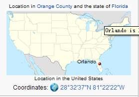
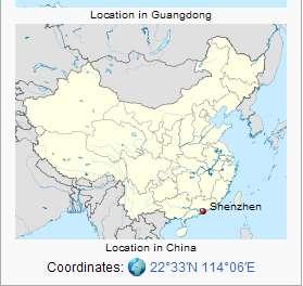
5 Background We choose two cities for studies. They are famed with distinguished amusement park attractions~ Orange County (Great Orlando area), Florida. (The City Beautiful) Shenzhen City (Great Shenzhen area), Guangdong. (The City of Ambition)


6 Background
7 Research Question How do hotels distribute in the two cities? Does different hotels have different preference for location? What factors contribute to hotel location?
8 Outline Introduction Background Data Source Research Methodology Preliminary Result
9 Data Source Orlando Data: Florida Geographic Data Library (FGDL): road and lodging facility data of Florida Orange County GIS Database: Zipcode area data, Airport data. Orlando City GIS Program: Landmark data Shenzhen Data: Dept. of Geography, Univ. of Nanjing
10 Hotel location in Orange County Legend CONDOMINIUM HOTEL MOTEL Highways Orange County Boundary 0 5,000 10,000 15,000 20,000 Meters Created by Yang Yang Dept. of Geography Univ. of Florida 12/01/2010 Projection: Albers Conical Equal Area
11 Hotel Location Map of Shenzhen type2 hotel type1 hotel type0 hotel Inner_roads Express roads Shenzhen City Created by Yang Yang, 12/04/ Kilometers
12 Outline Introduction Background Data Source Research Methodology Preliminary Result
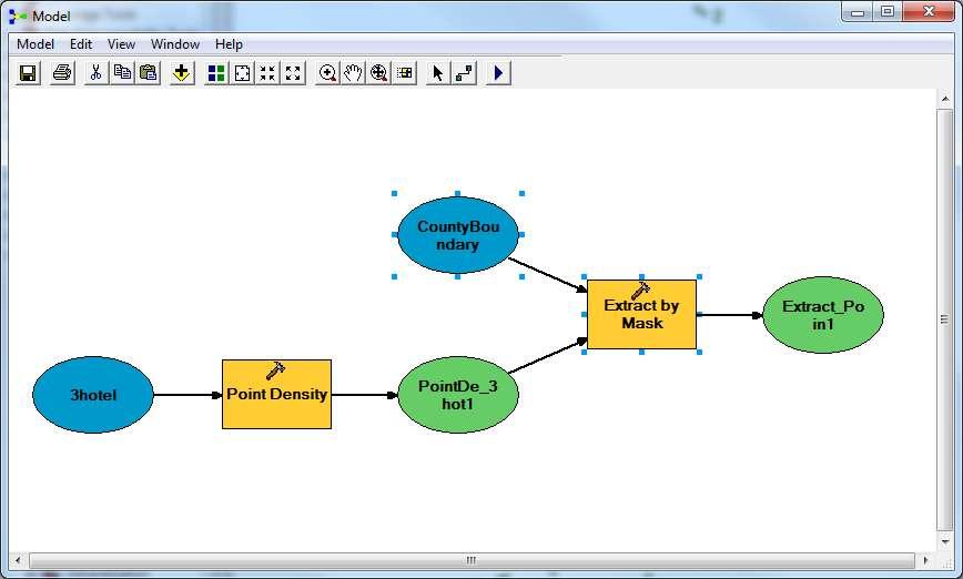
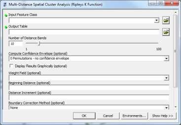
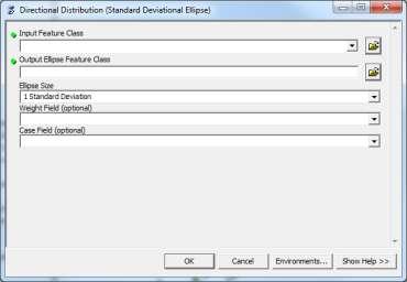
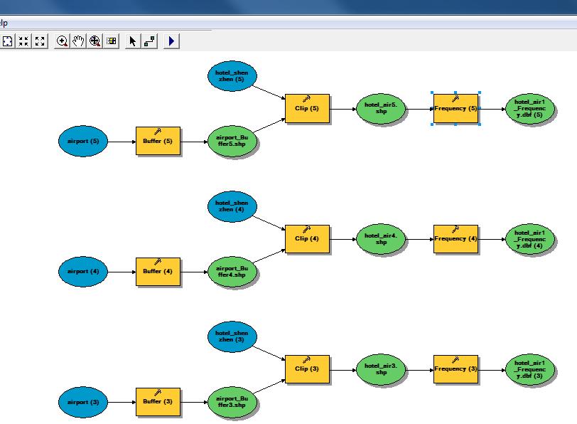
13 General Projection Skills Geodatabase design Map design Merge feature Distribution description Point density Extraction K-function Eclipse Nearest neighbor analysis Agglomeration analysis Buffer analysis Clip Frequency analysis Regression analysis Spatial join Near Regression analysis Functions Make all layers in the same projection Organize all project data in geodatabase for Orlando and Shenzhen respectively. Create location maps for hotels Union of line features To visualize hotel location Extract the point density (raster data) by mask To quantify the agglomeration of different hotels Compare the spatial distribution (direction and dispersion) Detect the agglomeration of location To measure the proximity of hotels to major roads, parks and airports. To general hotels within the buffering area To get frequency of hotels in different buffers Count number of hotels in different zones Find the nearest distance of hotels to parks Estimate each factor s contribution to hotel location
14
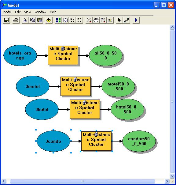
15 Research Methodology
16
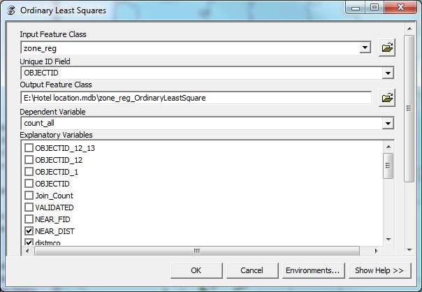
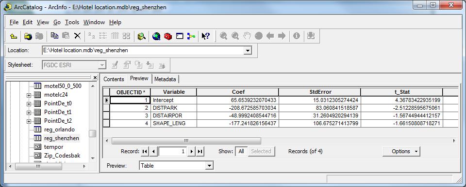
17 Research Methodology Hotel layer Spatial join Park layer Near Zone_reg Airport layer Road layer Near Spatial join Regression analysis Estimated coefficient table
18 Research Methodology
19 Outline Introduction Background Data Source Research Methodology Preliminary Result


20 Point Density of Hotel Location Density for condominums Density for motels Density for all categories 0 12,500 25,000 50,000 75, ,000 Feet FCreated by Yang Yang, Dept. of Geography, UF, 12/02/2010 Density for hotels


21 Point Density of Hotels in Shenzhen Preliminary Result Low-level hotels Middle-level hotels All hotels F Kilometers Created by Yang Yang, 12/04/2010 High-level hotels
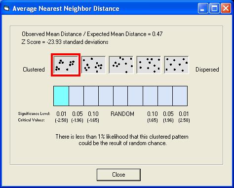
22 !! Hotel location in Orange County with Standard Deviational Ellipse MOTEL Legend CONDOMINIUM HOTEL MOTEL Highways Orange County Boundary! Ellipse HOTEL Ellipse CONDOMINIUM Ellipse 0 5,100 10,200 15,300 20,400 Meters Created by Yang Yang Dept. of Geography Univ. of Florida 12/01/2010 Projection: Albers Conical Equal Area
23 Preliminary Result
24 Preliminary Result Orlando Buffer Condominium Hotel Motel 1km 34.82% 33.93% 31.25% 2km 36.05% 37.21% 26.74% 3km 41.60% 34.20% 24.20% 4km 41.86% 33.72% 24.42% 5km 42.00% 33.90% 24.11% Orlando Buffer Condominium Hotel Motel 1km 6.25% 81.25% 12.50% 2km 14.86% 58.11% 27.03% 3km 46.70% 34.62% 18.68% 4km 41.31% 40.85% 17.84% 5km 55.18% 31.93% 12.89% Shenzhen Buffer low-level middle-level high-level 1km 65.71% 23.82% 10.47% 2km 69.08% 20.68% 10.23% 3km 70.69% 19.80% 9.50% 4km 71.37% 19.47% 9.16% 5km 71.43% 19.43% 9.14% Shenzhen Buffer low-level middle-level high-level 1km 50.00% 16.67% 33.33% 2km 64.29% 14.29% 21.43% 3km 62.50% 12.50% 25.00% 4km 60.53% 23.68% 15.79% 5km 64.58% 20.83% 14.58% Major Roads Amusement Park
25 Preliminary Result
26 Thanks you!
Social Community Accessibility
 Social Community Accessibility Australian Geography Teachers Conference 8-12 January University of Tasmania Launceston NEIL COFFEE UNIVERSITY OF ADELAIDE Geography V GIS? National Centre for Social Applications
Egnatia Odos Observatory. Egnatia Odos Observatory Monitoring of Egnatia Motorway s s Spatial Impacts
 Egnatia Odos Observatory Egnatia Odos Observatory Monitoring of Egnatia Motorway s s Spatial Impacts 1 Egnatia Odos Observatory 1. The unique Greek observatory of transport and spatial impacts 2. Scope
A GIS Analysis of Probable High Recreation Use Areas in Three Sisters Wilderness Deschutes and Willamette National Forests
 Lindsey Kiesz Geo 565 Term Project 3/15/2010 A GIS Analysis of Probable High Recreation Use Areas in Three Sisters Wilderness Deschutes and Willamette National Forests Introduction The Three Sisters Wilderness
Where is tourists next destination
 SEDAAG annual meeting Savannah, Georgia; Nov. 22, 2011 Where is tourists next destination Yang Yang University of Florida Outline Background Literature Model & Data Results Conclusion Background The study
INTERNATIONAL DRIVE ECONOMIC IMPACT ANALYSIS. Luis Nieves-Ruiz, AICP Economic Development Program Manager March 29, 2017
 INTERNATIONAL DRIVE ECONOMIC IMPACT ANALYSIS Luis Nieves-Ruiz, AICP Economic Development Program Manager March 29, 2017 EAST CENTRAL FLORIDA REGIONAL PLANNING COUNCIL One of 10 RPCs Non-profit Agency Technical
Fire and Forestry in Oxbow Regional Park, GIS and GPS Implementation
 Fire and Forestry in Oxbow Regional Park, GIS and GPS Implementation Brian Handy, Karen Sexton, Robert Pierce GIS and GPS implementation at Oxbow Regional Park, Oregon, in the preparation for fire danger
Satisfying the Need: Finding Potential Campsite Locations in Farewell Canyon, B.C. Alexis Moore
 Satisfying the Need: Finding Potential Campsite Locations in Farewell Canyon, B.C. Alexis Moore 230075923 Geog 413 Final Project Write- Up Roger Wheate April. 13, 2012 Introduction & Purpose of Study The
AIXM Annual Conference 2008 Day 2 March 19 th (morning) Migration TO and FROM AIXM from other AMDB Formats. Alan Poole/Dejan Damjanovic
 Migration TO and FROM AIXM from other AMDB Formats. Alan Poole/Dejan Damjanovic") AIXM Annual Conference 2008 Day 2 March 19 th (morning) Migration TO and FROM AIXM from other AMDB Formats Alan Poole/Dejan Damjanovic Overview Background and Problem Definitions. IATA AIS Data Pool Vision.
AIXM Annual Conference 2008 Day 2 March 19 th (morning) Migration TO and FROM AIXM from other AMDB Formats Alan Poole/Dejan Damjanovic Overview Background and Problem Definitions. IATA AIS Data Pool Vision.
MAPPING UNSHELTERED HOMELESSNESS IN INDIANAPOLIS ISSUE C17-20 NOVEMBER 2017
 MAPPING UNSHELTERED HOMELESSNESS IN INDIANAPOLIS ISSUE C17-20 NOVEMBER 2017 AUTHOR Chris Holcomb, Graduate Student, School of Public and Environmental Affairs, IUPUI 334 N. Senate Avenue, Suite 300 Indianapolis,
A GEOGRAPHIC ANALYSIS OF OPTIMAL SIGNAGE LOCATION SELECTION IN SCENIC AREA
 A GEOGRAPHIC ANALYSIS OF OPTIMAL SIGNAGE LOCATION SELECTION IN SCENIC AREA Ling Ruan a,b,c, Ying Long a,b,c, Ling Zhang a,b,c, Xiao Ling Wu a,b,c a School of Geography Science, Nanjing Normal University,
USE OF 3D GIS IN ANALYSIS OF AIRSPACE OBSTRUCTIONS
 USE OF 3D GIS IN ANALYSIS OF AIRSPACE OBSTRUCTIONS A project by by Samuka D. W. F19/1461/2010 Supervisor; Dr D. N. Siriba 1 Background and Problem Statement The Airports in Kenya are the main link between
Robson Valley Avalanche Tract Mapping Project
 Robson Valley Avalanche Tract Mapping Project Prepared for: Chris Ritchie Ministry of Water Land and Air Protection 325 1011 4th Avenue Prince George, BC. V2L3H9 and Dale Seip Ministry of Forests 1011
A GIS Assessment of Erosion Vulnerability for Unofficial Trails in the Columbia River Gorge
 A GIS Assessment of Erosion Vulnerability for Unofficial Trails in the Columbia River Gorge Sachi Arakawa Geog 593 Digital Terrain Analysis Fall 2017 Abstract The city of North Bonneville, located along
Disaster Evacuation Safe Zones in Clackamas County, Oregon Analysis: Two Scenarios
 Disaster Evacuation Safe Zone Analysis for Clackamas County, Oregon Part One: Caroline Rouwalk Part Two: Kathy Jepson June 3, 2008 http://gallery.photo.net/photo/5297534-md.jpg Disaster Evacuation Safe
THE DEVELOPMENT OF LUXOR OPEN AIR MUSUEM AND ITS SOCIAL IMPACTS AN ASSESSMENT USING GEOGRAPHIC INFORMATION SYSTEMS. Thesis submitted for the degree of
 THE DEVELOPMENT OF LUXOR OPEN AIR MUSUEM AND ITS SOCIAL IMPACTS AN ASSESSMENT USING GEOGRAPHIC INFORMATION SYSTEMS Thesis submitted for the degree of Doctor of Philosophy at the University of Leicester
Arizona Game and Fish Department Report for Inventory of Motorized Dispersed Campsites on the Tonto National Forest
 Arizona Game and Fish Department Report for Inventory of Motorized Dispersed Campsites on the Tonto National Forest Prepared By: ' _2-_.J_.., +-- / S IS Specialist II, Arizona Game and Fish Dep rtment
Airspace Complexity Measurement: An Air Traffic Control Simulation Analysis
 Airspace Complexity Measurement: An Air Traffic Control Simulation Analysis Parimal Kopardekar NASA Ames Research Center Albert Schwartz, Sherri Magyarits, and Jessica Rhodes FAA William J. Hughes Technical
AUGUST 2017 GNSS REVIEW. Survey Economics Chances of success. Mobile Mapping Airport scanning. Stag s Leap Winery Pre-construction plan
 AUGUST 2017 GNSS REVIEW Survey Economics Chances of success Stag s Leap Winery Pre-construction plan Mobile Mapping Airport scanning RISING PERFORMANCE» ERIK DAHLBERG Civil aviation is an outlier. It s
RISING PERFORMANCE. Civil aviation is an outlier. It s BY ERIK DAHLBERG
 RISING PERFORMANCE Compact mobile mapping systems can be installed on small passenger cars. Civil aviation is an outlier. It s among the few industries where tight government regulations are widely accepted
Business Intelligence Development at Winnipeg Transit
 ITS Canada Webinar February 28, 2013 Business Intelligence Development at Winnipeg Transit Bill Menzies Senior Transit Planner, Dillon Consulting Limited Manager of Service Development, Winnipeg Transit
Environmental Development of River Road Ranch
 Environmental Development of River Road Ranch New Braunfels, Texas Alix Scarborough GEO 3426 April 2012 Introduction The 2,400-acre Word-Borcher ranch has been owned by the Word family since 1941. Located
2009 Muskoka Airport Economic Impact Study
 2009 Muskoka Airport Economic Impact Study November 4, 2009 Prepared by The District of Muskoka Planning and Economic Development Department BACKGROUND The Muskoka Airport is situated at the north end
Provincial Land and Resource Management Initiative
 Provincial Land and Resource Management Initiative Esri Canada User Conference November 6, 2013 Gretchen Pohlkamp, Executive Director Land Services Department of Natural Resources The Problem Like most
Federal GIS Conference February 10 11, 2014 Washington DC. ArcGIS for Aviation. David Wickliffe
 Federal GIS Conference 2014 February 10 11, 2014 Washington DC ArcGIS for Aviation David Wickliffe What is ArcGIS for Aviation? Part of a complete system for managing data, products, workflows, and quality
Analysis of Aircraft Separations and Collision Risk Modeling
 Analysis of Aircraft Separations and Collision Risk Modeling Module s 1 Module s 2 Dr. H. D. Sherali C. Smith Dept. of Industrial and Systems Engineering Virginia Polytechnic Institute and State University
Introduction. Greece popular tourist destination ranked 32nd worldwide (2013) Tourism key pillar of the Greek economy
 Tourism key pillar of the Greek economy") Introduction Greece popular tourist destination ranked 32nd worldwide (2013) Tourism key pillar of the Greek economy FIG Working Week 2015 1 Methodology Data Collection Data Editing Geographical Analysis
Introduction Greece popular tourist destination ranked 32nd worldwide (2013) Tourism key pillar of the Greek economy FIG Working Week 2015 1 Methodology Data Collection Data Editing Geographical Analysis
"ST. KLIMENT OHRIDSKI FACULTY OF GEOLOGY AND GEOGRAPHY
 SOFIA UNIVERSITY "ST. KLIMENT OHRIDSKI FACULTY OF GEOLOGY AND GEOGRAPHY APPLICATION OF THE MODEL "DRIVING FORCES PRESSURE STATE - RESPONSE FOR ASSESSMENT OF FLOOD RISK RADOSTINA BORISOVA DOCHEVA Bachelor
Building Completion. Statistics Second Quarter. Building Completion Statistics I Second Quarter 2012
 Building Completion Statistics 2012 Second Quarter Date of Release: September 2012 1 Table of Contents Introduction... 3 Key Points... 4 Distribution of Building Completions by Region... 5 Distribution
Spatial Distribution and Characteristics of At-Risk Species in the Southeast U.S.
 Nicholas Institute for Environmental Policy Solutions Scoping Document Part 2 Exploratory Analysis of Characteristics and Trends of At-Risk Species in the Southeast U.S. Spatial Distribution and Characteristics
Massey Hall. 178 Victoria St, Toronto, ON M5B 1T7. CAP Index, Inc. REPORT CONTENTS. About CAP Index, Inc. 3-Mile Methodology. 3 Tract Map.
 REPORT CONTENTS 178 Victoria St, Toronto, ON M5B 1T7 About 3-Mile Methodology 2 Summary 3 Tract Map 4 Contour Map 5 Scores 6-Mile Methodology 6 Summary. 7 Tract Map 8 Contour Map 9 Scores 10 Proximity
Establishing a Risk-Based Separation Standard for Unmanned Aircraft Self Separation
 Establishing a Risk-Based Separation Standard for Unmanned Aircraft Self Separation Roland E. Weibel, Matthew W.M. Edwards, and Caroline S. Fernandes MIT Lincoln laboratory Surveillance Systems Group Ninth
A Statistical Method for Eliminating False Counts Due to Debris, Using Automated Visual Inspection for Probe Marks
 A Statistical Method for Eliminating False Counts Due to Debris, Using Automated Visual Inspection for Probe Marks SWTW 2003 Max Guest & Mike Clay August Technology, Plano, TX Probe Debris & Challenges
rtc transit Before and After Studies for RTC Transit Boulder highway UPWP TASK Before Conditions
 rtc transit Before and After Studies for RTC Transit UPWP TASK 3403-11-14 Before Conditions Report Boulder highway June 2011 Before and After Studies for RTC Transit BOULDER HIGHWAY BEFORE STUDY UPWP Task
West London Economic Assessment
 West London Economic Assessment A baseline analysis of the West London economy An Executive Summary PBA were commissioned in October 2015 to complete an economic assessment of West London to refresh the
APPENDIX OFFICIAL MAP ORDINANCE OF HAMILTONBAN TOWNSHIP OFFICIAL MAP NARRATIVE
 APPENDIX A OFFICIAL MAP ORDINANCE OF HAMILTONBAN TOWNSHIP OFFICIAL MAP NARRATIVE INTRODUCTION: The Official Map of Hamiltonban Township has been prepared to identify those lands and features that Hamiltonban
and Immigration U.S. Citizenship Services * This page is intentionally left blank. *
 U.S. Department of Homeland Security U.S. Citizenship and Immigration Services Immigrant Investor Program Mailstop 2235 Washington, DC 20529 U.S. Citizenship and Immigration Services Mr. James Lavigne
Directional Price Discrimination. in the U.S. Airline Industry
 Evidence of in the U.S. Airline Industry University of California, Irvine aluttman@uci.edu June 21st, 2017 Summary First paper to explore possible determinants that may factor into an airline s decision
The Travel & Tourism Industry in Vermont
 The Travel & Tourism Industry in Vermont A Benchmark Study of the Economic Impact of Visitor Expenditures on the Vermont Economy 2003 Prepared by: Introduction In 2003 Establishing clear and useful performance
Integrated Optimization of Arrival, Departure, and Surface Operations
 Integrated Optimization of Arrival, Departure, and Surface Operations Ji MA, Daniel DELAHAYE, Mohammed SBIHI ENAC École Nationale de l Aviation Civile, Toulouse, France Paolo SCALA Amsterdam University
Glacier Retreat/ Developement in Glacier National Park
 Geog 413 Term Project Glacier Retreat/ Developement in Glacier National Park Heather Miller December 01, 2004 Abstracts Introduction / background Data Source Data Manipulation Spatial analysis method/process
FLORIDA RESTAURANT & LODGING SHOW 2007
 FLORIDA RESTAURANT & LODGING SHOW 2007 EVENT AUDIT DATES OF EVENT: Conference: September 7 9, 2007 Exhibits: September 7 9, 2007 LOCATION: Orange County Convention Center, Orlando, FL EVENT PRODUCER/MANAGER:
From rail timetables to regional and urban indicators on rail passenger services
 From rail timetables to regional indicators on rail passenger services Hugo Poelman Linde Ackermans European Commission DG Regional and Urban Analysis Unit - GIS team Regional ITF statistical meeting,
SANBI PLANNING FORUM
 SANBI PLANNING FORUM SPATIAL PLANNING IN PROTECTED AREAS AND THEIR BUFFERS (South Africa) Ms Jayshree Govender, Dr Mike Knight and Mr Russell Smart 22 June 2017 OUTLINE 1) Introduction 2) Protected areas
Travel path and transport mode identification method using "less-frequently-detected" position data
 IOP Conference Series: Earth and Environmental Science OPEN ACCESS Travel path and transport mode identification method using "less-frequently-detected" position data To cite this article: T Shimizu et
Land Figures & Spatial Data Infrastructure in KOSOVO
 Land Figures & Spatial Data Infrastructure in KOSOVO Idriz SHALA idriz.shala@gmail.com GIS -expert Afrim SHARKU afrim.sharku@gmail.com Land Management - Expert Kick-off meeting of the Regional Expert Advisory
Wake Turbulence Research Modeling
 Wake Turbulence Research Modeling John Shortle, Lance Sherry Jianfeng Wang, Yimin Zhang George Mason University C. Doug Swol and Antonio Trani Virginia Tech Introduction This presentation and a companion
ASSESSING THE EFFECTS OF GEOSPATIAL FEATURES ON BIRD STRIKE OCCURRENCES AT SELECTED AIRPORTS IN THE US INTRODUCTION
 ASSESSING THE EFFECTS OF GEOSPATIAL FEATURES ON BIRD STRIKE OCCURRENCES AT SELECTED AIRPORTS IN THE US Frederick K. Wilson, Research Scientist/Lecturer Judy Jackson-Pringle, Research Associate School of
Part 77 CAA Consolidation 1 April 2014 Objects and Activities Affecting Navigable Airspace
 Part 77 CAA Consolidation 1 April 2014 Objects and Activities Affecting Navigable Airspace Published by the Civil Aviation Authority of New Zealand DESCRIPTION Part 77 prescribes rules for persons proposing
WELCOME! FORT LAUDERDALE-HOLLYWOOD INTERNATIONAL AIRPORT 14 CFR PART 150 NOISE AND LAND USE COMPATIBILITY STUDY
 WELCOME! FORT LAUDERDALE-HOLLYWOOD INTERNATIONAL AIRPORT 14 CFR PART 150 NOISE AND LAND USE COMPATIBILITY STUDY Public Information Workshop November 2017 1 14 CFR Part 150 Overview Establishes the methodology
An Automated Airspace Concept for the Next Generation Air Traffic Control System
 An Automated Airspace Concept for the Next Generation Air Traffic Control System Todd Farley, David McNally, Heinz Erzberger, Russ Paielli SAE Aerospace Control & Guidance Committee Meeting Boulder, Colorado
Digital Terrain Analysis of Archer Mountain
 Digital Terrain Analysis of Archer Mountain Identifying a potential new recreational trail Photo: Justin Bush GEOG 593 - Duh Marcus Tobey Justin Bush Project Overview Background Project Area Overview Questions
Building Completion. Statistics. Second Quarter. Building Completion Statistics I Second Quarter 2011
 Building Completion Statistics Building Completion Statistics I Second Quarter 211 Second Quarter Date of Release: March 212 1 Contents 1. Introduction... 2 2. Summary of Results.. 4 3. Distribution of
China Budget Hotel Industry Survey Report, 2010
 China Budget Hotel Industry Survey Report, 2010 In August 2010, ResearchInChina and 1DiaoCha conducted a joint survey of 600 consumers in mainland China over budget hotel consumer characteristics, including
Accommodation / Meeting Venue
 Accommodation / Meeting Venue Accommodation Guestrooms for 3GPP2 Shenzhen Meetings are arranged in Building B of Wuzhou Guest House. When check in, please reference 3GPP2 so that you can enjoy the favourable
Airport Land Use Compatibility Plan (ALUCP) Update. Public Information Meeting #2 December 1, 2015
 Update. Public Information Meeting #2 December 1, 2015") Airport Land Use Compatibility Plan (ALUCP) Update Public Information Meeting #2 December 1, 2015 Agenda 1. Welcome and Introductions 2. Status of Study 3. Long-term Planning Activity Level Annual Service
Airport Land Use Compatibility Plan (ALUCP) Update Public Information Meeting #2 December 1, 2015 Agenda 1. Welcome and Introductions 2. Status of Study 3. Long-term Planning Activity Level Annual Service
MONTEREY COUNTY TRAVEL IMPACTS P
 MONTEREY COUNTY TRAVEL IMPACTS 1992-2015P April 2016 Prepared for the Monterey County Convention and Visitors Bureau MONTEREY COUNTY TRAVEL IMPACTS, 1992-2015P Prepared for the Monterey County Convention
DIGITAL TERRAIN AND VIEWSHED ANALYSIS CRATER LAKE NATIONAL PARK
 DIGITAL TERRAIN AND VIEWSHED ANALYSIS OF FINDING THE IDEAL CAMPSITE ALONG THE PACIFIC CREST TRAIL Source: Outdoor Travel Blog DON RYAN DIGITAL TERRAIN ANALYSIS GEOG 593 PROJECT OVERVIEW LOCATION HISTORY
Land-Use and Water Quality Across the Cape Fear River Basin, NC: from 2001 to Jennifer Braswell Alford, PhD
 Land-Use and Water Quality Across the Cape Fear River Basin, NC: Exploring Spatial and Temporal Relationships from 2001 to 2006 Jennifer Braswell Alford, PhD Introduction There are over 3.6 million miles
Aerial Photography and Flight Planning
 Aerial Photography and Flight Planning What is VFR? Flight is to take place using visual references Must avoid clouds Normally have a distinguishable horizon Should have sight of the ground below, or in
PREFACE. Service frequency; Hours of service; Service coverage; Passenger loading; Reliability, and Transit vs. auto travel time.
 PREFACE The Florida Department of Transportation (FDOT) has embarked upon a statewide evaluation of transit system performance. The outcome of this evaluation is a benchmark of transit performance that
Fly Quiet Program Chicago O Hare International Airport
 4 th Quarter 213 Report Fly Quiet Program Chicago O Hare International Airport Chicago Department of Aviation Visit the O Hare Noise Management Webpage on the Internet at www.flychicago.com 4 th Quarter
Arizona National Scenic Trail
 1 The Arizona National Scenic Trail is an 800 mile recreation trail from Mexico to Utah that connects mountain ranges, canyons, deserts, forests, wilderness areas, historic sites, trail systems, points
2010 International Snow Science Workshop
 A GIS DATABASE FOR AVALANCHE FORECASTING IN COLORADO Douglas Scott 1* and Ethan Greene 2 1 Avalanche Mapping, Lafayette, Colorado, U.S.A. 2 Colorado Avalanche Information Center, Boulder, Colorado, U.S.A.
Henrico County Hotel and Motel Directory Hotels and Motels listed alphabetically by Magisterial District
 Henrico County Hotel and Motel Directory Hotels and Motels listed alphabetically by Magisterial District County of Henrico Planning Department September 2016 METHODOLOGY FOR THE 2016 HOTEL & MOTEL REPORT
Retreating Glaciers of the Himalayas: A Case Study of Gangotri Glacier Using Satellite Images
 Retreating Glaciers of the Himalayas: A Case Study of Gangotri Glacier Using 1990-2009 Satellite Images Jennifer Ding Texas Academy of Mathematics and Science (TAMS) Mentor: Dr. Pinliang Dong Department
Recapturing the Spatial Dynamics of the Venetian Occupation Period
 Recapturing the Spatial Dynamics of the Venetian Occupation Period of Merabello in Eastern Crete through a GIS Approach MARIANNA KATIFORI'-^ ' University of Crete, Dept. of History & Archaeology and Dept.
2012 Mat Su Valley Collision Avoidance Survey
 Table of Contents Table of Contents 1 INTRODUCTION Measurement Objectives 3 Methodology and Notes 4 Key Findings 5 PILOT LOCATION Activity in the Area 7 Pilot Location 8 Altitudes Flown 9 SAFETY IN THE
2004 SOUTH DAKOTA MOTEL AND CAMPGROUND OCCUPANCY REPORT and INTERNATIONAL VISITOR SURVEY
 2004 SOUTH DAKOTA MOTEL AND CAMPGROUND OCCUPANCY REPORT and INTERNATIONAL VISITOR SURVEY Prepared By: Center for Tourism Research Black Hills State University Spearfish, South Dakota Commissioned by: South
OVERVIEW OF THE LNP COLLARED ELEPHANTS MOVEMENTS
 LIMPOPO NATIONAL PARK MONTHLY REPORT Dry Season 2018: April-September OVERVIEW OF THE LNP COLLARED ELEPHANTS MOVEMENTS Anka Bedetti Elephant Tracking & ID Projects Manager Elephants Alive anka@elephantsalive.org
Managing beyond protected area boundaries: initial findings. Janis Smith Biodiversity Planning Forum 2017 Kruger National Park
 Managing beyond protected area boundaries: initial findings Janis Smith JSmith@csir.co.za Biodiversity Planning Forum 2017 Kruger National Park Background Protected areas the cornerstones of conservation
An analysis on the potential Motorways of the Sea alternative to all-road transport in the Ligurian - Northern Tyrrhenian area
 An analysis on the potential Motorways of the Sea alternative to all-road transport in the Ligurian - Northern Tyrrhenian area Marino Lupi, Alessandro Farina, Francesco Pilato, Antonio Pratelli University
Problematic Taxiway Geometry Study Overview
 DOT/FAA/TC-18/2 Federal Aviation Administration William J. Hughes Technical Center Aviation Research Division Atlantic City International Airport New Jersey 08405 Problematic Taxiway Geometry Study Overview
ANALYZING IMPACT FACTORS OF AIRPORT TAXIING DELAY BASED ON ADS-B DATA
 ANALYZING IMPACT FACTORS OF AIRPORT TAXIING DELAY BASED ON ADS-B DATA J. Li a, X. Wang a,*, Y. Xu b, Q. Li a, C. He a, Y. Li a a College of Geoscience and Surveying Engineering, China University of Mining
An outdoor waterpark is a facility offering three or more waterslides and other aquatic facilities.
 Methodology for Feasibility Studies for Waterparks By David J. Sangree, MAI, CPA, ISHC Before a developer or an organization considers constructing a new indoor or outdoor waterpark at a resort or standalone,
Jin Murakami City University of Hong Kong
 Institute of Urban and Regional Development (IURD) TRANSIT & CITIES CONFERENCE UC Berkeley March 20-21, 2014 Plenary Session 4: The Economics of Sustainable Transit Jin Murakami City University of Hong
Photopoint Monitoring in the Adirondack Alpine Zone
 Photopoint Monitoring in the Adirondack Alpine Zone Julia Goren (PI) and Seth Jones Adirondack High Peaks Summit Steward Program Adirondack Mountain Club summit@adk.org PO Box 867, Lake Placid, NY 12946
Ancient Egypt, Kush, and Israel
 500 1,000 miles T ER ES D N YA LIB 1 Geography and the Early Settlement of Egypt, Kush, and Canaan AFRICA NUBIAN DESERT ed 0 500 1,000 kilometers Sinusoidal (Sanson-Flamsteed) Projection S E ARABIAN PENINSULA
17: Good Design - Tombs Site
 Rural Design Workbook: 17: Good Design - Tombs Site Site Introduction: The Tombs/Sullivan/Horton site is located within the Town of Campbell and is a combination of three properties totaling 356 acres:
14 CFR PART 150 NOISE AND LAND USE COMPATIBILITY STUDY
 14 CFR PART 150 NOISE AND LAND USE COMPATIBILITY STUDY Technical Committee Meeting #3 March 7, 2018 1 Agenda Introductions Review of the Role of the TC Meeting Facilitator Review of Prior TC Meetings Public
New System. New Routes. New Way. May 20, 2014
 Route Optimization I N I T I A T I V E New System. New Routes. New Way. May 20, 2014 1 Welcome Blueprint for Transportation Excellence (BTE) 20 year strategic plan Blueprint 2020 JTA s five-year plan for
UPDATING THE SURFACE AREA AND VOLUME EQUATIONS OF LAKE NASSER USING MULTIBEAM SYSTEM
 UPDATING THE SURFACE AREA AND VOLUME EQUATIONS OF LAKE NASSER USING MULTIBEAM SYSTEM Nader M. Shafik Researcher, Nile Research Institute, E-mail: shafik_nader@yahoo.com ABSTRACT Lake Nasser is the main
Global Runway Safety Simposium
 Global Runway Safety Simposium A DIFFERENT PERSPECTIVE OF SAFETY AND ITS RELATIONSHIP WITH SURROUNDINGS Costantino Pandolfi LIMA, 11/21/2017 Italian Civil Aviation Authority ICAO ADOP Member Panel 8 New
Marine Debris Distribution, Variation and Pattern/Seasonal Changes along the Coast and on Sea Surface of the Kagoshima Bay
 Marine Debris Distribution, Variation and Pattern/Seasonal Changes along the Coast and on Sea Surface of the Kagoshima Bay Benjamin Dotto MAJANGA 1, Shigeru FUJIEDA 2, Ryuichiro NISHI 3 and Kazunori HOSOTANI
Asulkan Valley Avalanche track. Geography 477 Fall 2007 Penny Simpson, Jessica Paramio, Maciej Stetkiewicz, Ashley Dittmer
 Asulkan Valley Avalanche track Geography 477 Fall 2007 Penny Simpson, Jessica Paramio, Maciej Stetkiewicz, Ashley Dittmer RationaleRationale Objectives Background Methodology ResultsResults Discussion
Occupancy in North Carolina
 Smith Travel Research Year-End 2009 Lodging Report Year-end 2009 hotel/motel occupancy was down -9.0% statewide from 2008. This represents a decrease of -12.2% since 2005. o The US occupancy was down -8.6%
ECONOMIC IMPACT STUDY OF CALIFORNIA AIRPORTS
 ECONOMIC IMPACT STUDY OF CALIFORNIA AIRPORTS MARCH 1, 2013 Prepared for California Airports Council Prepared by Applied Development Economics 100 Pringle Avenue, Suite 560 Walnut Creek, California 94596
Nubia s Proximity to Egypt Equals a Lifetime of Egyptian Rule. Ancient Nubia is known for being Egypt s overlooked neighbor. Nubia is also known for
 Walker, Aleta CENG 105- WS Professor Peterson Cultural Analysis- Final Draft November 13, 2012 Nubia s Proximity to Egypt Equals a Lifetime of Egyptian Rule Ancient Nubia is known for being Egypt s overlooked
Potential of CO 2 retrieval from IASI
 Potential of CO 2 retrieval from IASI L. Chaumat, O. Lezeaux, P. Prunet, B. Tournier F.-R. Cayla (SISCLE), C. Camy-Peyret (LPMAA) and T. Phulpin (CNES) Study supported by CNES ITSC-XVI: Angra dos Reis,
Factors Influencing Visitor's Choices of Urban Destinations in North America
 Factors Influencing Visitor's Choices of Urban Destinations in North America Ontario Ministry of Tourism and Recreation May 21, 2004 Study conducted by Global Insight Inc. Executive Summary A. Introduction:
Member Analysis: USCIS Publishes Updated Policy on Regional Center Issues of Geography and Material Change
 Member Analysis: USCIS Publishes Updated Policy on Regional Center Issues of Geography and Material Change by Robert Divine, Shareholder, Baker, Donelson, Bearman, Caldwell & Berkowitz, P.C. and Kathleen
Washington Dulles International Airport (IAD) Aircraft Noise Contour Map Update. 6th Working Group Briefing 1/7/19
 Aircraft Noise Contour Map Update. 6th Working Group Briefing 1/7/19") Washington Dulles International Airport (IAD) Aircraft Noise Contour Map Update 6th Working Group Briefing 1/7/19 Study Purpose Agenda Background Summary of last stakeholder meetings Refresher on DNL,
Washington Dulles International Airport (IAD) Aircraft Noise Contour Map Update 6th Working Group Briefing 1/7/19 Study Purpose Agenda Background Summary of last stakeholder meetings Refresher on DNL,
Great Wolf Lodge Fact Sheet & Frequently Asked Questions Potential Location in Gilroy, California 8/30/17
 WHAT? Great Wolf Resorts has identified Gilroy, California as a potential location for a new Great Wolf Lodge family resort and has entered into a 60-day period of exclusivity with the City and community
Characteristics of a Well Clear Definition and Alerting Criteria for Encounters between UAS and Manned Aircraft in Class E Airspace!
 National Aeronautics and Space Administration Characteristics of a Well Clear Definition and Alerting Criteria for Encounters between UAS and Manned Aircraft in Class E Airspace! NASA Ames Research Center
Validation of Runway Capacity Models
 Validation of Runway Capacity Models Amy Kim & Mark Hansen UC Berkeley ATM Seminar 2009 July 1, 2009 1 Presentation Outline Introduction Purpose Description of Models Data Methodology Conclusions & Future
Fly Quiet Program Chicago O Hare International Airport
 2 nd Quarter 211 Report Fly Quiet Program Chicago O Hare International Airport Chicago Department of Aviation Visit the Community Noise Resource Center on the Internet at www.flychicago.com 2 nd Quarter
ICTAP Program. Interoperable Communications Technical Assistance Program. Communication Assets Survey and Mapping (CASM) Tool Short Introduction
 Tool Short Introduction") ICTAP Program Interoperable Communications Technical Assistance Program Communication Assets Survey and Mapping (CASM) Tool Short Introduction Outline Overview General Information Purpose Security Usage
ICTAP Program Interoperable Communications Technical Assistance Program Communication Assets Survey and Mapping (CASM) Tool Short Introduction Outline Overview General Information Purpose Security Usage
PELICAN LANDING RAPTOR BAY REZONING TRANSPORTATION METHODOLOGY OUTLINE
 PELICAN LANDING RAPTOR BAY REZONING TRANSPORTATION METHODOLOGY OUTLINE Project No. 15534 Prepared by: DAVID PLUMMER & ASSOCIATES, INC. 2149 McGregor Boulevard June 24, 2016 Fort Myers, Florida 33901 Pelican
PKF Consulting Canada
 PKF Consulting Canada July 27, 2015 Carol Caputo Executive Director Ontario s Algoma Country 334 Bay Street Sault Ste. Marie, ON P6A 1X1 Via e mail: carol@algomacountry.com RE: ALGOMA COUNTRY ACCOMMODATION
Spatial information as a forensic tool to investigate crime
 Spatial information as a forensic tool to investigate crime 4 th Biennial Conference Dr Peter Schmitz 9 October 2012 Overview Introduction Geographic profiling Examples of geographic profiling in South
How much is it? An innovative methodology to measure room rates across OTAs and online platforms
 How much is it? An innovative methodology to measure room rates across OTAs and online platforms Ariel Juárez / Pedro A. Anzo / Arturo Constantini @ArielJuarezM / @pedroarmando_an / @ArturoRConstan1 Ministry