"ST. KLIMENT OHRIDSKI FACULTY OF GEOLOGY AND GEOGRAPHY
|
|
|
- Gregory Gardner
- 5 years ago
- Views:
Transcription


1 SOFIA UNIVERSITY "ST. KLIMENT OHRIDSKI FACULTY OF GEOLOGY AND GEOGRAPHY APPLICATION OF THE MODEL "DRIVING FORCES PRESSURE STATE - RESPONSE FOR ASSESSMENT OF FLOOD RISK RADOSTINA BORISOVA DOCHEVA Bachelor Degree of Regional Development and Politics Future master degree of Planning and Management of Territorial Systems

2 APPLICATION OF THE MODEL DPSR FOR ASSESSMENT OF FLOOD RISK Goal Assessment of flood risk and optimization of measures for flood protection Subject of research Rositsa river basin 2
3 Methodological approach Based on the European Environmental Agency (EEA) framework Driving forces - Pressures - State - Impact Responses (DPSIR) Climate Landscape factors Changes in land use Urbanization Transport infrastructure Soil sealing PRESSURES DRIVING FORCES RESPONSES Measures to prevent, protect and mitigate the negative consequences Historical and future flooding Types of floods Maximum flow STATE IMPACT Damages Socio-economic consequences Environmental impacts 3
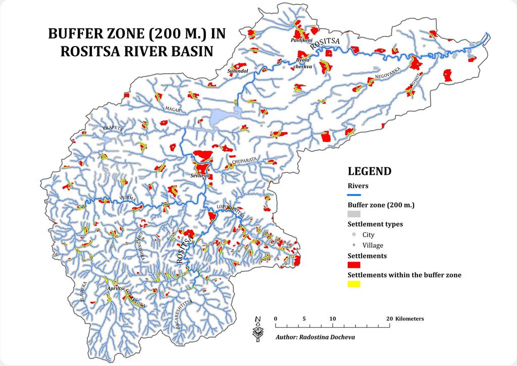
4 Used method Introduction of "criteria for horizontal distance/offset Horizontal distance between an object (settlements, industrial or cultural sites, railways, roads, protected natural areas, etc.) and the nearby river In Rositsa river case that horizontal offset is 200 m. River 1 Settlement 1 Settlement 2 X m X m Threat of flooding X m X m River 2 Flood risk Settlement 3 4
5 Assessment of unfavorable impacts According to the requirements of the Directive 2007/60/EC (on the assessment and management of flood risks, ) are used several categories human health, economic activity, environment and cultural heritage Human health Assessed according to the criteria Number of affected residents Economic activity Assessed according to the criteria Area of industrial and commercial sites, Length of railway lines, Length of roads, Area of agricultural land Environment Assessed according to the criteria Area of protected areas Cultural heritage Assessed according to the criteria Number of cultural monuments Used software ArcGIS Desktop 9.3 & ArcGIS Desktop 10 (ESRI) Adverse effects They are defined for past and future floods in Rositsa river basin 5
6 Used information Spatial Information Represented by digital models of the terrain, geology, settlements, railways, roads, rivers, soils, vegetation, protected areas NATURA 2000, Corine Land Cover 2000 & 2006, Google earth, etc. Statistical and other information Including hydro-climatic data from the meteorological and hydrometric networks in Rositsa river basin 6
7 DRIVING FORCES Climate Landscape factors ROSITSA RIVER BASIN Application of the model Increased atmospheric humidity with significant frequency and duration of torrential rainfall Average annual precipitation 120/ /170 days 150/160 events with intense rains (the average for Bulgaria is 50/60 events) Huge potential conditions for the formation of snow that subsequently forms extreme high waters Many specific landscape conditions that intensify the water flow 7
8 8
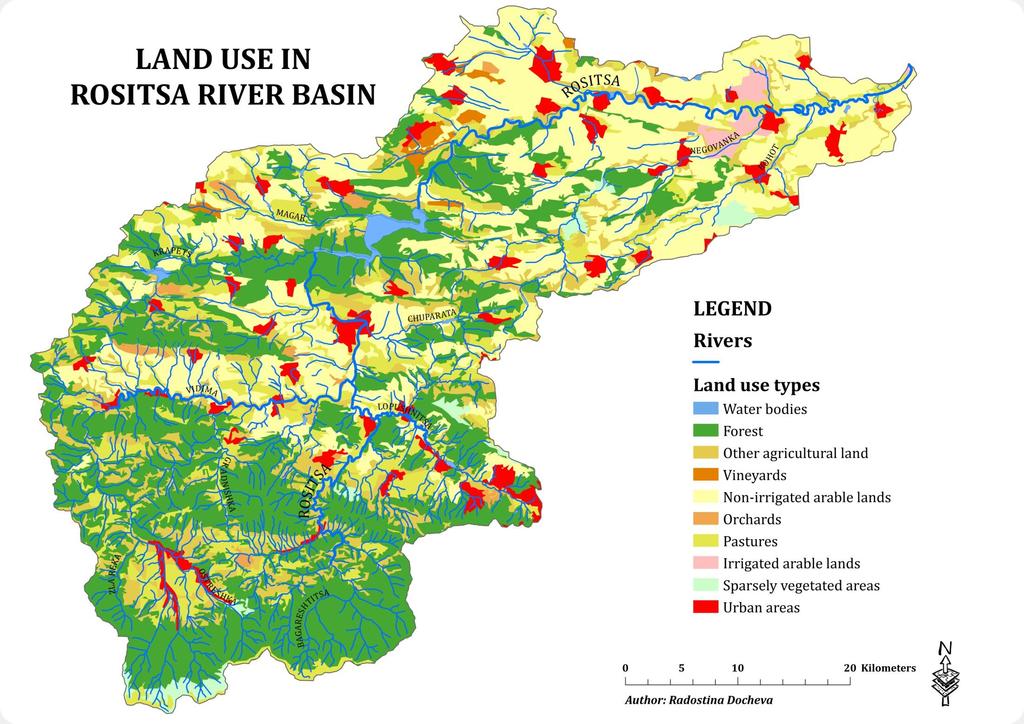
9 PRESSURES Changes in land use Urbanization Transport infrastructure Soil sealing ROSITSA RIVER BASIN Application of the model Agricultural land, including non-irrigated and irrigated fields km² Forests km² Pastures km² 143 settlements (incl. 5 cities) The density of the urban network 5.9 settlements/100 km² 133 cities are located in the 200 m. buffer zone around rivers The total area of these settlements, constitutes 35.8 % of the total area of settlements in the Rositsa river basin However, some of the most urbanized areas in the basin (cities Sevlievo, Pavlikeni, Suhindol, Apriltsi and Byala cherkva) are located in the buffer zone Significant potential flood risk Roads, the main elements of the transport infrastructure, are built mostly in the floodplains of rivers Lack of drainage systems Enhances the effect of heavy rainfall and cause more frequent occurrence of floods Compared with year 2000, the growth rate of soil sealing is insignificant 9
10 10
11 11
12 12
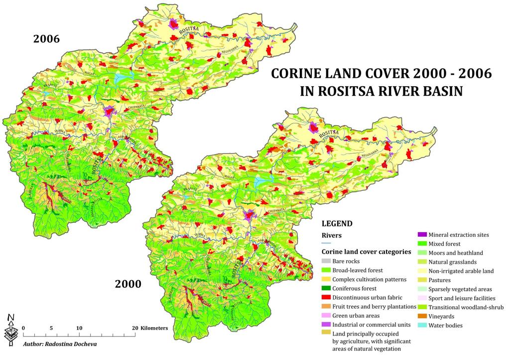
13 CATEGORIES CORINE LAND COVER 2006 (% of total area) CORINE LAND COVER 2000 (% of total area) Water bodies 0,59 0,58 Bare rocks 0,05 0,06 Natural grasslands 1,79 1,91 Green urban areas 0,002 0,002 Land principally occupied by agriculture, with significant areas of natural vegetation 12,97 13,25 Coniferous forest 0,72 0,52 Industrial or commercial units 0,82 0,84 Mineral extraction sites 0,05 0,05 Complex cultivation patterns 4,13 4,36 Vineyards 0,65 0,78 Sport and leisure facilities 0,03 0,03 Discontinuous urban fabric 4,69 4,65 Non-irrigated arable land 32,01 31,74 Fruit trees and berry plantations 1,35 1,13 Pastures 5,62 5,67 Sparsely vegetated areas 0,01 0,01 Transitional woodland-shrub 4,60 4,40 Moors and heathland 0,13 0,13 Mixed forest 8,96 8,93 Broad-leaved forest 20,83 20,97 Conclusion Minor changes in land use 13
14 14
15 STATE Historical and future flooding Types of floods Maximum flow ROSITSA RIVER BASIN Application of the model Rositsa river basin is one of the basins in Bulgaria with the highest torrential regimes Catastrophic floods for the region , , , , , , , , , , , , , , Rositsa river basin is characterized by a maximum module 9,76 m³/s of km² That is a historical maximum for Europe, too. 15
16 IMPACT Damages Socio-economic consequences Environmental impacts ROSITSA RIVER BASIN Application of the model Negative impact on protected categories of "human health and "economic activity" from historical floods For example, in year 1939 the flood affected: 964 residential buildings, mainly in the village of Gorna Rositsa (450) and Sevlievo (470) In 1858 and 1901 the whole northern part of Sevlievo has been under water Information on human victims 1901 (2 children), 1939 (47 people), etc. In year 1939 the largest number of farm buildings were affected in the upper reaches of the river (Stokite 105, Batoshevo - 77, Gorna Rositsa 43), while large areas of flooded and destroyed agricultural lands were in the lower reaches of Rositsa river (Suhindol hectares) 16
17 Negative impact on protected categories from potential (future) floods AFFECTED PEOPLE FROM FLOODS Settlements within the 200 m. buffer zone from rivers Size of urban area (km 2 ) Settlement area, within the 200 m. buffer zone from rivers (km 2 ) Population Population density, (people/km 2 ) Number of affected people Apriltsi Byala cherkva Pavlikeni Sevlievo Suhindol
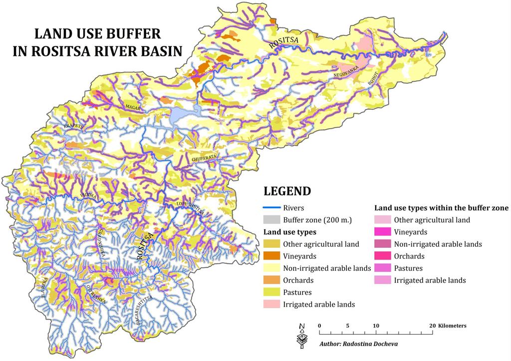
18 POTENTIAL FLOOD RISK IN ROSITSA RIVER BASIN PROTECTED AREAS CRITERIA TOTAL IN THE BUFFER ZONE OF 200 M. % "ECONOMIC ACTIVITY" ENVIRONMENT "CULTURAL HERITAGE" Industry Industrial and commercial units (km 2 ) 18,46 6, Transport infrastructure Length of road network (km) 1038,12 471, Length of rail road network (km) 50,16 9, Agriculture Other agricultural land (km 2 ) 270,28 102, Vineyards (km 2 ) 16,55 4, Non-irrigated arable land (km 2 ) 665,30 148, Orchards (km 2 ) 17,59 5, Pastures (km 2 ) 311,69 113, Irrigated arable land (km 2 ) 18,29 3, Protected areas NATURA 2000 Alexander Stamboliyski dam 100 Rositsa river 100 Archaeological sites
19 RESPONSES Measures to prevent, protect and mitigate the negative consequences ROSITSA RIVER BASIN Application of the model So far in the basin are taken only civil engineering measures - safety walls and dikes 19
20 20
21 21
22 22
23 23
24 24
25 25
26 Conclusion Essential role in the formation and occurrence of floods in the river basin have driving forces and particular geography of the Rositsa river basin Intensification of torrential processes and flood risk is the result primarily of the ongoing urbanization process in the basin and transport infrastructure associated with the construction of settlements and roads mainly in the 200 m. buffer zone from the river As a result of the influence of forces and pressures, Rositsa river basin experienced the most catastrophic floods in Bulgaria Negative effects from past floods mainly affect the protected categories "human health" and "economic activity" Preliminary assessment of flood risk carried out based on "criteria for horizontal distance/offset indicates that a significant potential risk has "human health" and to a lesser extent to categories of "economic activity" and "environment There is no potential risk for category "cultural heritage"
Land Figures & Spatial Data Infrastructure in KOSOVO
 Land Figures & Spatial Data Infrastructure in KOSOVO Idriz SHALA idriz.shala@gmail.com GIS -expert Afrim SHARKU afrim.sharku@gmail.com Land Management - Expert Kick-off meeting of the Regional Expert Advisory
Prof. Dr Željko Vaško Doc. Dr Tihomir Predić MSc Boris Marković
 First Interim Meeting of the Regional Expert Advisory Working Group on Areas with Natural Constrains Prof. Dr Željko Vaško Doc. Dr Tihomir Predić MSc Boris Marković 29 th June 01 th July, 2016 Andrevlje,
GEOGRAPHY AND HISTORY
 GEOGRAPHY AND HISTORY YEAR 1, PART 1 www.vicensvives.es Contents 01 Our planet Earth 02 The representation of the Earth: maps 03 The Earth s relief 04 Rivers and seas 05 Weather and climate 06 Climates
Dr. Dimitris P. Drakoulis THE REGIONAL ORGANIZATION OF THE EASTERN ROMAN EMPIRE IN THE EARLY BYZANTINE PERIOD (4TH-6TH CENTURY A.D.
 Dr. Dimitris P. Drakoulis THE REGIONAL ORGANIZATION OF THE EASTERN ROMAN EMPIRE IN THE EARLY BYZANTINE PERIOD (4TH-6TH CENTURY A.D.) ENGLISH SUMMARY The purpose of this doctoral dissertation is to contribute
Natural and man-made flooding hazards at the torrents in the town of Thessaloniki
 Risk Analysis VII PI-373 Natural and man-made flooding hazards at the torrents in the town of Thessaloniki S. Stefanidis, F. Tziaftani & C. Chatzicristaki Institute of Mountainous Water Management and
Water quality management in the Lake Baikal region of Russia
 Lomonosov Moscow State University Faculty of Geography Department of Environmental Management Water quality management in the Lake Baikal region of Russia Dr., Prof. Sergey Kirillov Dr., Prof. Mikhail
AGRITECH th December 2017, Podgorica
 AGRITECH 2017 06-07 th December 2017, Podgorica AGRI Potentials of Capital City Podgorica Vladimir Pavićević, MSc Deputy Secretary Secretariat for labor, youth and social care Main characteristics of Montenegro
ORTHOLOGICAL MANAGEMENT OF HYDROLOGICAL RUNOFF BASINS OF THE PREFECTURE OF DRAMA (CURRENT SITUATION PROTECTIVE ACTIONS PERSPECTIVES)
") ORTHOLOGICAL MANAGEMENT OF HYDROLOGICAL RUNOFF BASINS OF THE PREFECTURE OF DRAMA (CURRENT SITUATION PROTECTIVE ACTIONS PERSPECTIVES) This paper presents the torrential environment of the torrents of the
ORTHOLOGICAL MANAGEMENT OF HYDROLOGICAL RUNOFF BASINS OF THE PREFECTURE OF DRAMA (CURRENT SITUATION PROTECTIVE ACTIONS PERSPECTIVES) This paper presents the torrential environment of the torrents of the
Ocho Rios, Jamaica GEF-IWCAM AND IABIN INDICATORS MECHANISM WORKSHOP March TNC s Marine Protected Area Work.
 TNC s Marine Protected Area Work in the Caribbean GEF-IWCAM AND IABIN INDICATORS MECHANISM WORKSHOP 10-12 March 2008 Ocho Rios, Jamaica Caribbean Decision-Support System 3 years (2003-2006) $2.2 million
THE ALBERTA GAZETTE, SEPTEMBER
 VILLAGE OF CEREAL Order No. 16915 IN THE MATTER OF THE "Municipal Government Act": File No. 241(A)3 AND IN THE MATTER OF an application by the Council of the Village of Cereal, in the Province of Alberta,
What Is An Ecoregion?
 Ecoregions of Texas What Is An Ecoregion? Ecoregion a major ecosystem with distinctive geography, characteristic plants and animals, and ecosystems that receives uniform solar radiation and moisture Sometimes
SANBI PLANNING FORUM
 SANBI PLANNING FORUM SPATIAL PLANNING IN PROTECTED AREAS AND THEIR BUFFERS (South Africa) Ms Jayshree Govender, Dr Mike Knight and Mr Russell Smart 22 June 2017 OUTLINE 1) Introduction 2) Protected areas
SIAVONGA DISTRICT
 SIAVONGA DISTRICT --------------------------------------------------------------------------------------------------------- 1.0 Physical Environment Siavonga District is characterized by an escarpment
EXPLORING BIOMES IN GORONGOSA NATIONAL PARK
 EXPLORING BIOMES IN GORONGOSA NATIONAL PARK ABOUT THIS WORKSHEET This worksheet complements the Click and Learn Gorongosa National Park Interactive Map (http://www.hhmi.org/biointeractive/gorongosa-national-park-interactive-map),
From rail timetables to regional and urban indicators on rail passenger services
 From rail timetables to regional indicators on rail passenger services Hugo Poelman Linde Ackermans European Commission DG Regional and Urban Analysis Unit - GIS team Regional ITF statistical meeting,
UNIT 5 AFRICA PHYSICAL GEOGRAPHY SG 1 - PART II
 UNIT 5 AFRICA PHYSICAL GEOGRAPHY SG 1 - PART II III. CLIMATE & VEGETATION A. The four main climate zones are tropical wet, tropical wet/dry (split into monsoon & savanna), semiarid, and arid. Other climate
Region 1 Piney Woods
 Region 1 Piney Woods Piney Woods 1. This ecoregion is found in East Texas. 2. Climate: average annual rainfall of 36 to 50 inches is fairly uniformly distributed throughout the year, and humidity and temperatures
Chapter 16 ~ Eastern Mediterranean
 Chapter 16 ~ Eastern Mediterranean Physical Geography of the Eastern Mediterranean Landforms This area is known as the Levant and includes Syria, Jordan, Lebanon, Israel, and the Palestinian territories.
2.1 What is the climate like?
 José Medeiros This fact sheet allows you to see how varied the countryside is across Brazil. 2.1 What is the climate like? Most of Brazil is in the Southern Hemisphere, where the seasons are the opposite
Destruction of dolines: the examples from Slovene karst
 Destruction of dolines: the examples from Slovene karst dr. Gregor Kovačič (1) and dr. Nataša Ravbar (2) (1) University of Primorska, Faculty of humanities Koper, Science and Research Centre, Koper, Slovenia
Settlement Patterns West of Ma ax Na, Belize
 SETTLEMENT PATTERNS WEST OF MA AX NA, BELIZE 1 Settlement Patterns West of Ma ax Na, Belize Minda J. Hernke Faculty Sponsor: Kathryn Reese-Taylor, Department of Sociology/Archaeology ABSTRACT The focus
Unit 9 The Middle East SG 1 - Physical Geography, Population & Demographics
 Unit 9 The Middle East SG 1 - Physical Geography, Population & Demographics I. Physical Geography A. The Middle East includes southwestern Asia and North Africa. 1. The name is Eurocentric. Middle East
EUROPEAN COMMISSION DG XI.D.2. COUNCIL DIRECTIVE 79/409/EEC on the conservation of wild birds. and
 EUROPEAN COMMISSION DG XI.D.2 COUNCIL DIRECTIVE 79/409/EEC on the conservation of wild birds and COUNCIL DIRECTIVE 92/43/EEC on the conservation of natural habitats and of wild fauna and flora STANDARD
KNOWLEDGE NOTE 1-3. Hydro-meteorological Disasters Associated with Tsunamis and Earthquakes. CLUSTER 1: Structural Measures
 Public Disclosure Authorized Public Disclosure Authorized Public Disclosure Authorized Public Disclosure Authorized KNOWLEDGE NOTE 1-3 CLUSTER 1: Structural Measures Hydro-meteorological Disasters Associated
COUNTRY CASE STUDIES: OVERVIEW
 APPENDIX C: COUNTRY CASE STUDIES: OVERVIEW The countries selected as cases for this evaluation include some of the Bank Group s oldest (Brazil and India) and largest clients in terms of both territory
Socio-demographic and Economic Profiles of the Regions in the Republic of Macedonia
 Spatial demography of the Balkans: trends and challenges IV th International Conference of Balkans Demography Session 5: Planning and development challenges -----------------------------------------------------------------------------------------------
Chapter 16 ~ Eastern Mediterranean
 Chapter 16 ~ Eastern Mediterranean Physical Geography of the Eastern Mediterranean Landforms This area is known as the Levant and includes Syria, Jordan, Lebanon, Israel, and the Palestinian territories.
ANALYSIS OF INADEAUTE WATER QUALITY OD THE RESERVOIR VONARJE/SUTLA LAKE AND POSSIBILITY OF RESTORATION AND UTILIZATION
 EC project on Integration of Natural Water Retention Measures in river basin management The 1 st Danube Region Workshop ANALYSIS OF INADEAUTE WATER QUALITY OD THE RESERVOIR VONARJE/SUTLA LAKE AND POSSIBILITY
RECREATION POTENTIAL ASSESMENT AS ASSUMPTION FOR TOURISM REGIONALIZATION OF SLOVAKIA TERRITORY
 RECREATION POTENTIAL ASSESMENT AS ASSUMPTION FOR TOURISM REGIONALIZATION OF SLOVAKIA TERRITORY Jan SUPUKA - Roberta ŠTĚPÁNKOVÁ Slovak Agriculture University in Nitra, The Slovak Republic International
Brain Wrinkles. Africa: The impact of location, climate, & physical characteristics on where people live, the type of work they do, & how they travel
 Africa: The impact of location, climate, & physical characteristics on where people live, the type of work they do, & how they travel STANDARDS: SS7G3 The student will explain the impact of location, climate,
THE IMPORTANCE OF NATURAL ELEMENTS FOR THE DEVELOPMENT OF TOURISM IN NEGORSKA SPA - GEVGELIJA IN MACEDONIA
 Socio economic geography; Teachnig & Education in Geography THE IMPORTANCE OF NATURAL ELEMENTS FOR THE DEVELOPMENT OF TOURISM IN NEGORSKA SPA - GEVGELIJA IN MACEDONIA DOI: http://dx.doi.org/10.18509/gbp.2015.41
Just how big is Africa?
 The United States China India The United Kingdom Portugal Spain France Belgium Germany The Netherlands Switzerland Italy Eastern Europe Japan 11.7 million sq. miles Just how big is Africa? Chapter 18 Section
Public Works Research Institute
 Public Works Research Institute INTERNATIONAL WORKSHOP ON WATER HAZARD AND RISK MANAGEMENT SOME EXPERIENCES OF FLOOD MANAGEMENT IN ARGENTINA VÍCTOR POCHAT National Director for Water Policies,Coordination
ENVIRONMENTAL PROFILE:
 Pyrenees Study Area for LEDDRA LOCATION: The Pyrenees study area is located in the Spanish Central Pyrenees (42º 36 N, 0º 00 E), in the Sobrarbe area (Huesca province, Aragón region). It includes the municipalities
Zoran Đuroković, B. Sc. (Civ.Eng.) Davor Haničar, B. Sc. (Civ.Eng.) Ladislav Grđan, B. Sc. (Civ.Eng.) Silvio Brezak, B. Sc. (Civ.Eng.
 Davor Haničar, B. Sc. (Civ.Eng.) Ladislav Grđan, B. Sc. (Civ.Eng.) Silvio Brezak, B. Sc. (Civ.Eng.") FLOOD PROTECTION EXPERIENCES ON THE DRAVA RIVER BASIN IN CROATIA Maribor, September 23-25 2008 Zoran Đuroković, B. Sc. (Civ.Eng.) Davor Haničar, B. Sc. (Civ.Eng.) Ladislav Grđan, B. Sc. (Civ.Eng.) Silvio
FLOOD PROTECTION EXPERIENCES ON THE DRAVA RIVER BASIN IN CROATIA Maribor, September 23-25 2008 Zoran Đuroković, B. Sc. (Civ.Eng.) Davor Haničar, B. Sc. (Civ.Eng.) Ladislav Grđan, B. Sc. (Civ.Eng.) Silvio
CANADA CARIBBEAN DISASTER RISK MANAGEMENT FUND. Island Snapshot. Trinidad and Tobago
 Island Snapshot Trinidad and Tobago About the CCDRMF The Canada Caribbean Disaster Risk Management Fund (CCDRMF) is one component of Global Affairs Canada s 1 (GAC) larger regional Caribbean Disaster Risk
Brazil. Chapter 12. Chapter 12, Section
 Chapter 12, Section World Geography Chapter 12 Brazil Copyright 2003 by Pearson Education, Inc., publishing as Prentice Hall, Upper Saddle River, NJ. All rights reserved. Chapter 12, Section World Geography
Portuguese Language - Fostering National Unity
 Geography Brazil Brazil Portuguese Language - Fostering National Unity 11 dialects of Portuguese Influenced by Amerindian and African languages, creating differences between Portuguese spoken in Brazil
Summary table of disaster occurrences, by hazards types, scale, and geographic region
 ANNEX BASIC RANGE OF DISASTER-RELATED STATISTICS TABLES Statistical tables are organised into worksheets according to basic components in the DSRF. The variables represent queries from a disaster-related
Reference: 06/13/0594/F Parish: Fritton & St Olaves Officer: Mrs M Pieterman Expiry Date:
 Schedule of Planning Applications Committee Date: 21 st January 2014 Reference: 06/13/0594/F Parish: Fritton & St Olaves Officer: Mrs M Pieterman Expiry Date: 20-01-2014 Applicant: Proposal: Site: Lord
Value of the Basic and Essential Family Baskets in Galapagos
 Value of the Basic and Essential Family Baskets in Galapagos Charles Darwin Foundation The Ecuadorian National Institute of Statistics and Censuses (INEC Instituto Nacional de Estadística y Censos) determines
ECORREGIONAL ASSESSMENT: EASTERN CORDILLERA REAL ORIENTAL PARAMOS AND MONTANE FORESTS
 ECORREGIONAL ASSESSMENT: EASTERN CORDILLERA REAL ORIENTAL PARAMOS AND MONTANE FORESTS The Nature Conservancy, EcoCiencia y Fundación AGUA. 2005. Evaluación Ecorregional de los Páramos y Bosques Montanos
The Geological Pacific Northwest. Wednesday February 6, 2012 Pacific Northwest History Mr. Rice
 The Geological Pacific Northwest Wednesday February 6, 2012 Pacific Northwest History Mr. Rice 1 Free Response #2 Please do not simply list the items for this response. Full sentences!!! Minimum of 3-5
Sustainable development: 'Lanzarote and the Biosphere strategy'. LIFE97 ENV/E/000286
 Sustainable development: 'Lanzarote and the Biosphere strategy'. LIFE97 ENV/E/000286 Project description Environmental issues Beneficiaries Administrative data Read more Contact details: Project Manager:
Lessons Learned from the Floods this May
 Building Resiliance to Disasters in Western Balkans and Turkey Design a Regional Multi-Hazard EWS Composed of harmonized National EWS econd Meeting of the Design Team 9 11 September 2014, Durrës, Albania
Chapter 2: El Dorado County Characteristics and Demographics
 Chapter 2: El Dorado County Characteristics and Demographics 2.1 Geographic Area and Demographics El Dorado County comprises 1,805 square miles with over half of the area in the Eldorado National Forest
Latin America. Physical Geography
 + Latin America Physical Geography + I. Landforms A. Caribbean & Central America 1. Mexico is dominated by two mountain chains, collectively called the Sierra Madre. A high plateau is situated in between.
Designated Sites. Headlines
 Designated Sites Headlines Over 36% of the Sheffield district is covered by sites with European, national or local designation. These offer valuable habitats to wildlife, with some level of protection,
THE DISINTEGRATION OF SETTLEMENTS IN BOSNIA AND HERZEGOVINA THE EXAMPLE OF SARAJEVO/EAST SARAJEVO
 THE DISINTEGRATION OF SETTLEMENTS IN BOSNIA AND HERZEGOVINA THE EXAMPLE OF SARAJEVO/EAST SARAJEVO DOI: http://dx.doi.org/10.18509/gbp.2017.25 UDC: 911.372.9(497.15) Mariana Lukić Tanović 1 Draško Marinković
THE MUNICIPALITY of PROZOR-RAMA
 Bosnia and Herzegovina Federation of Bosnia and Herzegovina Herzegovina-Neretva Canton THE MUNICIPALITY of PROZOR-RAMA I T S D E V E L O P M E N T S T R A T E G Y B U S I N E S S ZONES S U B S I D Y S
SUPPORT TO WATER RESOURCES MANAGEMENT IN THE DRINA RIVER BASIN DRAFT ROOF REPORT INTRODUCTION AND GENERAL APPROACH
 SUPPORT TO WATER RESOURCES MANAGEMENT IN THE DRINA RIVER BASIN DRAFT ROOF REPORT INTRODUCTION AND GENERAL APPROACH Nadja Zeleznik, REC Public Concultation Beograd, Serbia, 4 July 2017 1 1. Introduction
Satisfaction of Tourists Towards Mae Fa Luang Garden
 Thai J. For. 26 : 31-39 (2007) 26: 31-39 (2550) ORIGINAL ARTICLE Satisfaction of Tourists Towards Mae Fa Luang Garden Krit Kantawan 1 Santi Suksard 1 Wuthipol Hoamuangkaew 1 1 Department of Forest Management,
Nicaragua versus Costa Rica?
 Nicaragua versus Costa Rica? Overview: Today I want to look at Nicaragua versus Costa Rica from both a destination for retiree s standpoint and for potential investment interest. First I'll provide some
"Transboundary coordination according to the FD Directive in the shared river basins of Greece
 Workshop on Transboundary Issues Budapest March 31st April 1st "Transboundary coordination according to the FD Directive in the shared river basins of Greece Katerina Triantafyllou, ECOS Consulting S.A.
2014 floods in Serbia
 16 th Meeting of WGF, Rim, 9-10 October 2014 2014 floods in Serbia Radovanka Pavlović Ministry of Agriculture and Environmental Protection Republic Water Direcrorate, Belgrade, Serbia Specific cyclone
GEOSPATIAL ANALYSIS OF GLACIAL HAZARDS PRONE AREAS OF SHIGAR AND SHAYOK BASINS OF PAKISTAN. By Syed Naseem Abbas Gilany
 GEOSPATIAL ANALYSIS OF GLACIAL HAZARDS PRONE AREAS OF SHIGAR AND SHAYOK BASINS OF PAKISTAN By Syed Naseem Abbas Gilany PRESENTATION OUTLINE Introduction Problem Statement / Rationale Objectives Material
Vision for Development of Georgia's High Mountainous Regions adapted to the Climate and Landscape Changes
 Vision for Development of Georgia's High Mountainous Regions adapted to the Climate and Landscape Changes George Gotsiridze 3rd EURO-ASIAN MOUNTAIN RESORTS CONFERENCE 4-7 April, 2017, Tbilisi, Georgia
DIAGNOSIS OF STATE OF RURAL TOURISM IN BORINO MUNICIPALITY
 Trakia Journal of Sciences, Vol. 15, Suppl. 1, pp 36-41, 2017 Copyright 2017 Trakia University Available online at: http://www.uni-sz.bg ISSN 1313-7069 (print) ISSN 1313-3551 (online) doi:10.15547/tjs.2017.s.01.007
GLOFs from moraine-dammed lakes: their causes and mechanisms V. Vilímek, A. Emmer
 GLOFs from moraine-dammed lakes: their causes and mechanisms V. Vilímek, A. Emmer Department of Physical Geography and Geoecology, Faculty of Science, Charles University, Prague, Czech Republic vilimek@natur.cuni.cz
Welcome to AVI AFRIQUE 2017
 Welcome to AVI AFRIQUE 2017 Single African sky and Functional Airspace Blocks: Improving Air Traffic Management The global ATM operational concept is fundamental framework drive ATM operational requirements,
Module 1 Educator s Guide: Representative Discussion Points Investigation 3
 Module 1 Educator s Guide: Representative Discussion Points Investigation 3 Ethiopia and Eritrea Our combined population is 59,578,171 people. We have just emerged from a long period of civil war and famine.
Crete Study Site Description
 Crete Study Site Description 1. Location Crete (the largest island of Greece) is located in the south part of Greece covering an area of 8.335 km 2 or 6.3% of the Greek territory, including the surrounding
5 Rail demand in Western Sydney
 5 Rail demand in Western Sydney About this chapter To better understand where new or enhanced rail services are needed, this chapter presents an overview of the existing and future demand on the rail network
SAMTRANS TITLE VI STANDARDS AND POLICIES
 SAMTRANS TITLE VI STANDARDS AND POLICIES Adopted March 13, 2013 Federal Title VI requirements of the Civil Rights Act of 1964 were recently updated by the Federal Transit Administration (FTA) and now require
 AGREEMENT Between Director of the Białowieża National Park, based in Białowieża (Poland) and Director of the National Park Bialowieża Forest, based in Kamieniuki (Belarus) and Head Forester of the Białowieża
Brief Description of Northern the West Bank, Palestine Prepared by: Dr. Ahmed Ghodieh Department of Geography An-Najah National University Nablus,
 Brief Description of Northern the West Bank, Palestine Prepared by: Dr. Ahmed Ghodieh Department of Geography An-Najah National University Nablus, Palestine Brief Description of Northern the West Bank
Alternatives Study of Alignment
 Project: 4-lanning of Barhi Rajauli Section of NH-31 Sheet: 1 of 6 Alternatives Study of Alignment 1 Objectives The following objectives were kept in view while locating the alternative bypass alignments:
The Danube Experience
 The Danube Experience Dealing with Hydromorphological Issues the Danube Experience Philip Weller Executive Secretary, ICPDR Danube River Basin- Overview The Danube River Basin is the most international
Intermediate report. Letter of agreement FAO - GCB/RAB/013/ITA
 Treated waste water for sustainable production of valuable biomass, soil and water quality improvement and combating desertification in Algeria and Tunisia Letter of agreement FAO - GCB/RAB/013/ITA Intermediate
CAP CONTEXT INDICATORS
 CAP CONTEXT INDICATORS 2014-2020 34. NATURA 2000 AREAS 2017 update CONTEXT INDICATOR 34: NATURA 2000 AREAS In 2016, the Natura 2000 sites (SPAs + SCIs) covered 18.2 % of the terrestrial area of the EU-
North Africa. Chapter 25. Chapter 25, Section
 Chapter 25, Section World Geography Chapter 25 North Africa Copyright 2003 by Pearson Education, Inc., publishing as Prentice Hall, Upper Saddle River, NJ. All rights reserved. Chapter 25, Section World
Terms of Reference (ToR) for a Short-Term assignment
 for a Short-Term assignment") Terms of Reference (ToR) for a Short-Term assignment Technical assistance requested Expert for climate change mitigation and adaptation Project Title Outline of the Climate Adaptation Strategy and basin-wide
Terms of Reference (ToR) for a Short-Term assignment Technical assistance requested Expert for climate change mitigation and adaptation Project Title Outline of the Climate Adaptation Strategy and basin-wide
SUSTAINABLE AND ENVIRONMENTALLY FRIENDLY TOURISM IN THE COASTAL ZONES OF THE BALTIC SEA AREA
 CONVENTION ON THE PROTECTION OF THE MARINE ENVIRONMENT OF THE BALTIC SEA AREA HELSINKI COMMISSION - Baltic Marine HELCOM 21/2000 Environment Protection Commission Minutes of the Meeting 21st Meeting Helsinki,
How to develop resilient infrastructure (Global SDG9)
") How to develop resilient infrastructure (Global SDG9) 16-17 November 2017, Ljubljana, Slovenia Development of resilient rail infrastructure, practices in the Republic of Macedonia Darko Miceski Viktorija
How to develop resilient infrastructure (Global SDG9) 16-17 November 2017, Ljubljana, Slovenia Development of resilient rail infrastructure, practices in the Republic of Macedonia Darko Miceski Viktorija
Dipl. Ing. Ansonia Lillo Tor Dean University of Santo Tomás - Arica Chile
 Dipl. Ing. Ansonia Lillo Tor Dean University of Santo Tomás - Arica Chile In Chile, the environmental matters have been faced up intensely during the past years. Despite this, just in the last year it
The Timok River Basin in Serbia
 The Timok River Basin in Serbia UNECE Workshop on Integrated Transboundary Water Resources Management in SEE, Sarajevo, 18-20 May, 2009 Dragana Ninković, Dipl.-Ing. Dušan Dobričić, Dipl.-Ing. Content 1.
NATIONAL SENIOR CERTIFICATE NATIONAL GRADE 12
 NATIONAL SENIOR CERTIFICATE NATIONAL GRADE 12 GEOGRAPHY P1 FEBRUARY/MARCH 2013 ANNEXURE This annexure consists of 12 pages. Geography/P1 2 DBE/Feb. Mar. 2013 FIGURE 1.1: GLOBAL PRESSURE BELTS AND WINDS
4/28/17. Clicker Question. Clicker Question. #37 Floods IV (Case Histories-Mississippi River Flood, 1993; Red River of North Flood, 1997)
") GEOL 118 Final Exam Format similar to exams 1 and 2 Covers Lectures #27 40 (Global Climate Change I - Meteorite Impacts III) Web Exercise #6 - Due by 1 pm, Monday (5/1) 8:00 AM, Thursday, May 11 th Location
GEOL 118 Final Exam Format similar to exams 1 and 2 Covers Lectures #27 40 (Global Climate Change I - Meteorite Impacts III) Web Exercise #6 - Due by 1 pm, Monday (5/1) 8:00 AM, Thursday, May 11 th Location
MAPs sector in Bosnia and Herzegovina
 MAPs sector in Bosnia and Herzegovina CEDDEM Decembre 2016 Bosnia & Herzegovina Official Name: Bosnia and Herzegovina (BH) Political system: Parliamentary democracy with a bicameral parliament; BH is composed
THIRD HOMEWORK ASSIGNMENT Settlement Patterns
 Tulane University Chris Rodning NAME INTRODUCTION TO ARCHAEOLOGY ANTH 334 F2008 SCORE of 30 points THIRD HOMEWORK ASSIGNMENT Settlement Patterns This assignment asks you to discuss settlement pattern data
Tourism Satellite Accounts : The Demand Perspective
 Tourism Satellite Accounts : The Demand Perspective Tourism Gross Fixed Capital Formation and Tourism Collective Consumption Demi Kotsovos Satellite Accounts and Special Studies National Economic Accounts
ALBERTA S GRASSLANDS IN CONTEXT
 ALBERTA S GRASSLANDS IN CONTEXT GLOBAL GRASSLANDS 1 Temperate grasslands, located north of the Tropic of Cancer and south of the Tropic of Capricorn, are one of the world s great terrestrial biomes 2.
Friday, November 10, 2017
 Friday, November 10, 2017 Andes and Midlatitude Countries Objective: Summarize the main physical features and regions of the Southern Cone. Identify and locate the urban centers and understand the pattern
Chapter 20. The Physical Geography of Africa South of the Sahara
 Chapter 20 The Physical Geography of Africa South of the Sahara Chapter Objectives Identify the major landforms, water systems, and natural resources of Africa south of the Sahara. Describe the relationship
Managing beyond protected area boundaries: initial findings. Janis Smith Biodiversity Planning Forum 2017 Kruger National Park
 Managing beyond protected area boundaries: initial findings Janis Smith JSmith@csir.co.za Biodiversity Planning Forum 2017 Kruger National Park Background Protected areas the cornerstones of conservation
Presentation from 2015 World Water Week in Stockholm. The authors, all rights reserved. SIWI siwi.org
 Presentation from 2015 World Water Week in Stockholm www.worldwaterweek.org The authors, all rights reserved SIWI siwi.org WORLD WATER WEEK Stockholm, 23 th August 2015 Co-operative water governance: catalyst
TERRITORY AND INFRASTRUCTURES TERRITORY INFRASTRUCTURES
 AND INFRASTRUCTURES INFRASTRUCTURES Territory Surface area, 2015 Biogeographical areas. Aragon. Km 2 % of Spain % of UE-28 Aragon 47,720.3 9.4 1.0 Spain 505,988.0 10.6 UE-28 4,787,766.3 Source: Aragon
Regional Cooperation on Flood Management in the Sava River Basin
 Regional Cooperation on Flood Management in the Sava River Basin Flood Risk Management Plans: international experiences by comparison Mirza Sarač ISRBC Secretariat Content Introduction Sava River Basin
City tourism: a successful product
 City tourism: a successful product Observation and analytical units. Tourist Destination Management (area 16) Inmaculada Gallego Galán and Ana Moniche Bermejo Department of Statistics and Market Research.
Development of Ski Resorts in the Indian Himalayas
 Development of Ski Resorts in the Indian Himalayas AMITABH SHARMA SKI HIMALAYAS # 1 Pocket 52, C.R Park New Delhi 110019 +91-9816055555 Email : amitabhsharma_manali@rediffmail.com The Himalayas are a vast
!!!!!!!!!!Mali s Geographic Makeup
 DANU Strategic Forecasting Group May 27th 2016!!!!!!!!!!Mali s Geographic Makeup By Liliana Pirlea Location: Mali is a landlocked country located in West Africa. Mali is the 8th largest country in Africa
Nansanga Profile. Population and Land Use.
 Nansanga Profile Population and Land Use. Settlements in Nansanga are linearly aggregated in plateau area along the Serenje Mapepala road, with densely populated Mukomansala, Mapepala, Shindaila, and Nabowa
Presented by: Ms. Kanageswary Ramasamy Department of Statistics, Malaysia February 2017
 Presented by: Ms. Kanageswary Ramasamy Department of Statistics, Malaysia 14-16 February 2017 1 INTRODUCTION 2 INTERNATIONAL RECOMMENDATIONS ON TOURISM STATISTICS (IRTS) 2008 3 RECOMMENDED METHODOLOGICAL
GROWTH AREA PROFILES CITY CENTRES. Henderson. Past. g r o w t h management s t r a t e g y. Henderson 1940
 CITY CENTRES Past In 1940 was still a relatively small rural service town, surrounded by established vineyards and orchards, the Borough having a total population of approximately 1,500 people. By the
4) Data sources and reporting ) References at the international level... 5
 Data sources and reporting ) References at the international level... 5") D- 1: Protected areas (PA) 1) General description... 2 1.1) Brief definition... 2 1.2) Units of measurement... 2 1.3) Context...2 2) Relevance for environmental policy... 2 2.1) Purpose... 2 2.2) Issue...
D- 1: Protected areas (PA) 1) General description... 2 1.1) Brief definition... 2 1.2) Units of measurement... 2 1.3) Context...2 2) Relevance for environmental policy... 2 2.1) Purpose... 2 2.2) Issue...
Jeneberang River. Serial No. : Indonesia-10 Location: South Sulawesi Area: 727 km 2 Origin: Mt. Bawakaraeng (2,833 MSL) Outlet: Makassar Strait
 Outlet: Makassar Strait") Jeneberang River Map of River Table of Basic Data Name: Jeneberang River Serial No. : Indonesia-10 Location: South Sulawesi S 5 10' 00" - 5 26' 00" E 119 23' 50" - 119 56' 10" Area: 727 km 2 Origin: Mt.
Jeneberang River Map of River Table of Basic Data Name: Jeneberang River Serial No. : Indonesia-10 Location: South Sulawesi S 5 10' 00" - 5 26' 00" E 119 23' 50" - 119 56' 10" Area: 727 km 2 Origin: Mt.
The Pilcomayo River Basin Argentina
 The Pilcomayo River Basin Argentina Yangareko ( Janis Alcorn, Alejo Zarzycki, Alonzo Zarzycki, Luis Maria de la Cruz) Governance and Ecosystems Management for the CONservation of BIOdiversity www.gemconbio.eu
ANNEX V. List of Abbreviations
 ANNEX V List of Abbreviations SEE R&D EU TEN-T GROSEE FP NUTS LAU ESPON Cohesion SMART SWOT MEGA FUA GDP PUSH PIA TRACC RO BG GR EUROSTAT BBU OTP FYROM EC FMA FOCI ECR2 South East Europe Research and Development
CHAPTER IV OVERVIEW. Indonesia. The capital is Dompu. Dompu Regency has an area of 2, km².
 CHAPTER IV OVERVIEW A. General Description of the Research Sites Dompu Regency, is a district in West Nusa Tenggara Province, Indonesia. The capital is Dompu. Dompu Regency has an area of 2,321.55 km².
Whangarei Airport. Prepared by Carine Andries 10/20173
 Whangarei Airport Prepared by Carine Andries 10/20173 March 2010 TABLE OF CONTENTS 1 2 3 INTRODUCTION... 3 AIRPORT ROLE AND FUNCTION... 3 AIRPORT FEATURES AND CAPACITY... 3 3.1 3.2 3.3 3.4 3.5 3.5.1 3.5.2