Satisfying the Need: Finding Potential Campsite Locations in Farewell Canyon, B.C. Alexis Moore
|
|
|
- Poppy Butler
- 6 years ago
- Views:
Transcription
1 Satisfying the Need: Finding Potential Campsite Locations in Farewell Canyon, B.C. Alexis Moore Geog 413 Final Project Write- Up Roger Wheate April. 13, 2012
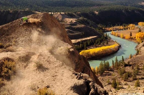
2 Introduction & Purpose of Study The purpose of this project was just as the title states to find potential campsite locations within Farewell canyon to satisfy the need that currently exists by users of this gorgeous region. Farewell canyon is beautiful place, carved out over thousands of years by the Chilcotin River and home to world famous mountain biking trails, bighorn sheep, and stunning views (Fig. 1, 2, 3, 4). Personally, I have spent a lot of time enjoying this area along with many other people. The one problem with this area though is that when you want to spend a night or two camping out, there is no provincial or forestry campsite area to stay at. In fact, the closest forestry campsite is in Riske Creek km away as the crow flies or 20.6 km driving distance. This has resulted in people having to do a rogue style of camping, always unsure of whether they were on private or crown land. This is of course stressful for the camper and potentially the private landowner as well, where it isn t uncommon for them to protect their land with reasonable force. Due to this need, in this project I have performed data assembling and spatial, surface and raster analysis to locate suitable campsite areas. There is also a large provincial park nearby - Junction Sheep Range Provincial Park - with the edge of it seen shaded in green (Fig. 5, 6). Its park boundary could potentially be extended to include this new campsite area, or the area could become a new forestry campsite.

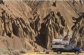
3 Fig. 1 Fig. 2 Fig. 3 Fig. 4 Fig. 1, 2, 3 & 4 Source: LXiAK05YXICw&sa=X&oi=mode_link&ct=mode&cd=2&ved=0CBEQ_AUoAQ&biw=1272&bih=702&sei=71iLT53ZC 8ifiQLbvfCxCw


4 Fig. 5. Source: Fig. 6. Source:


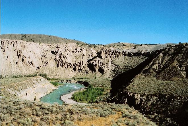
5 Study Area & Data Source Farewell Canyon is located at ' 34.85", ' 55.27", 68.3 km SW of Williams Lake, B.C., and can be seen in Fig. 7. A close- up satellite view from Google Maps can be seen in Fig. 8 and a Terrain Bender image from a previous project of mine in Fig. 9. I downloaded all the data, two 1:20K TRIM I mapsheets 92O 78 & 88, from the UNBC GIS Data Download site at Fig. 7. Source: Fig. 9 Fig. 8. Source:
6 Methods & Analysis After downloading the mapsheets I used FME Universal Translator to merge the saif files and convert them to one shapefile. I then opened ArcMap to do my analysis. First I created a boundary around my new study area to which I could clip any water bodies. Next I converted the river lines into polygons using the Feature to Polygon tool. I chose not to include streams in this area as the Chilcotin River is the only water source flowing through this arid and desert canyon. Next I created a DEM from the contour lines using the Topo to Raster tool from 3D Analyst. From this I created a hillshade. I also used its Spatial Analyst feature to get slope and aspect. I then queried and extracted polygon areas with slopes less than 5 degrees and aspect facing south ( degrees). I chose these parameters as a campsite area should be relatively flat for those who have RV s and trailers, and since the campsite area would be within the canyon it would be important for it to get as much sunlight as possible and have good exposure in general. Next I made 1000 m buffer polygons around the gravel roads and made m, m, and m river buffer polygons from the Chilcotin River. I choose a minimum distance of at least 100 m from the river to reduce flood risk and for a general safety buffer for children and pets. Finally, I intersected the slope, aspect, road and river polygons; I did this in 3 separate intersections one for each river buffer. This resulted in 3 zones. I wanted to have these zones so that there would be options for the builders of the campsite area to select the best areas once they were on the ground. Also, if all zones were implemented campsite users could have the choice of where to camp based on personal preferences such as safety and noise in terms of distance to water and their affinity for water.
7 Results & Conclusion The resulting map from my analysis can be seen in Fig. 9. Since the canyon is a relatively small area in terms of road access, the map is a large scale. The three different suitable camping areas can be seen in Zones 1, 2, & 3, with the optimal areas of the three seen circled in red (Fig. 10). Zone 1 would be best for those looking to be right close to the river, enjoy the beach and maybe do some fishing. It could also potentially be the walk- in area of the campsite, allowing for a more rugged feel for those that prefer to use tents. Zone 2 would work for people who want to be relatively close to the river, but also have a better view of the canyon. It is also the largest level zone of the three, which would mean easy access and set up for those with RV s and a closer feel for those who like to have neighbors and be social. Lastly, Zone 3 would be enjoyed best by those who want to take in the grand views of this canyon, have more space and privacy, and be able to ride their bikes down trails that leave right from their campsite. All zones also have camp- side access to many other walking and biking trails as well as cultural features such as hieroglyphics and the Pioneer Homestead (Fig. 9).
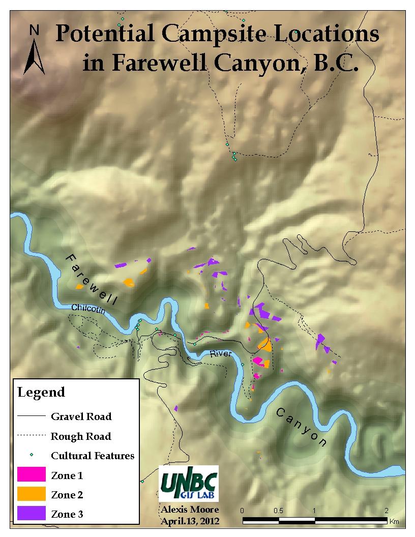
8 Fig. 10
9 Fig. 11
A GIS Analysis of Probable High Recreation Use Areas in Three Sisters Wilderness Deschutes and Willamette National Forests
 Lindsey Kiesz Geo 565 Term Project 3/15/2010 A GIS Analysis of Probable High Recreation Use Areas in Three Sisters Wilderness Deschutes and Willamette National Forests Introduction The Three Sisters Wilderness
DIGITAL TERRAIN AND VIEWSHED ANALYSIS CRATER LAKE NATIONAL PARK
 DIGITAL TERRAIN AND VIEWSHED ANALYSIS OF FINDING THE IDEAL CAMPSITE ALONG THE PACIFIC CREST TRAIL Source: Outdoor Travel Blog DON RYAN DIGITAL TERRAIN ANALYSIS GEOG 593 PROJECT OVERVIEW LOCATION HISTORY
Glacier Retreat/ Developement in Glacier National Park
 Geog 413 Term Project Glacier Retreat/ Developement in Glacier National Park Heather Miller December 01, 2004 Abstracts Introduction / background Data Source Data Manipulation Spatial analysis method/process
Fire and Forestry in Oxbow Regional Park, GIS and GPS Implementation
 Fire and Forestry in Oxbow Regional Park, GIS and GPS Implementation Brian Handy, Karen Sexton, Robert Pierce GIS and GPS implementation at Oxbow Regional Park, Oregon, in the preparation for fire danger
Note that the steepest 8 direction pour point model slope in direction 64 is: 10.0
 GIS in Water Resources Exercise #3 Solution Part 1. 1.1 Hand Calculations (i) The standard ESRI surface slope function Grid size 10 m Diagonal distance= 14.142 m 47.5 48 47.7 50.6 48.3 dz/dx= -0.125 45.1
Environmental Development of River Road Ranch
 Environmental Development of River Road Ranch New Braunfels, Texas Alix Scarborough GEO 3426 April 2012 Introduction The 2,400-acre Word-Borcher ranch has been owned by the Word family since 1941. Located
Digital Terrain Analysis of Archer Mountain
 Digital Terrain Analysis of Archer Mountain Identifying a potential new recreational trail Photo: Justin Bush GEOG 593 - Duh Marcus Tobey Justin Bush Project Overview Background Project Area Overview Questions
Disaster Evacuation Safe Zones in Clackamas County, Oregon Analysis: Two Scenarios
 Disaster Evacuation Safe Zone Analysis for Clackamas County, Oregon Part One: Caroline Rouwalk Part Two: Kathy Jepson June 3, 2008 http://gallery.photo.net/photo/5297534-md.jpg Disaster Evacuation Safe
Trail Phasing Plan. Note: Trails in the Clear Creek Canyon area (Segments will be finalized in the future to minimize wildlife impacts
 Note: Trails in the Clear Creek Canyon area (Segments 2 5 and a future JCOS connection) will be finalized in the future to minimize wildlife impacts Trail Phasing Plan P Parking 3 Easy Trail Intermediate
Invest in Waterfront Property
 Invest in Waterfront Property Day Lake $599,000 Total Acreage: 465 acres Private lakefront parcel located in North-Central BC Private Lakefront Retreat www.niho.com (604) 606-7900 Private Lakefront Retreat!
Spatial Assessment for the revised Mpumalanga Biodiversity Expansion Strategy. Mervyn Lotter Scientific Services 8 June 2016
 Spatial Assessment for the revised Mpumalanga Biodiversity Expansion Strategy Mervyn Lotter Scientific Services 8 June 2016 Mpumalanga Protected Area Expansion Strategy (MPAES) Developed our first MPAES
Other Agencies and Organizations
 Daniel Boone National Forest 1700 Bypass Road WInchester, KY 40391 859-745-3100 Location Northern terminus is near Morehead, Kentucky. Southern terminus is located in the Big South Fork NRRA in Tennessee.
A GIS Assessment of Erosion Vulnerability for Unofficial Trails in the Columbia River Gorge
 A GIS Assessment of Erosion Vulnerability for Unofficial Trails in the Columbia River Gorge Sachi Arakawa Geog 593 Digital Terrain Analysis Fall 2017 Abstract The city of North Bonneville, located along
Trail Beginning Elevation: 7553 ft The Poison Creek Trailhead is located at the end of National Forest Road 646E (NF-646E).
.") West Mountain Trails Poison Creek Trail #134 Length: 2.9 miles (4.7 km) Difficulty Horseback: A good trail for the first time west mountain rider, some steep sections Hiking: Most Difficult USGS Maps:
West Mountain Trails Poison Creek Trail #134 Length: 2.9 miles (4.7 km) Difficulty Horseback: A good trail for the first time west mountain rider, some steep sections Hiking: Most Difficult USGS Maps:
2015 British Columbia Parks. Visitor Survey. Juan De Fuca Park. China Beach
 2015 British Columbia Parks Visitor Survey Juan De Fuca Park China Beach 1 Contents Introduction 3 Methodology 3 Limitations 3 How this report is organized 3 Part 1 - Visitor Satisfaction 4 Part 2 - Visitor
Hotel Location Analysis using ArcGIS
 Hotel Location Analysis using ArcGIS Yang Yang Department of Geography University of Florida Outline Introduction Background Data Source Research Methodology Preliminary Result Introduction Location! Location!
AIXM Annual Conference 2008 Day 2 March 19 th (morning) Migration TO and FROM AIXM from other AMDB Formats. Alan Poole/Dejan Damjanovic
 Migration TO and FROM AIXM from other AMDB Formats. Alan Poole/Dejan Damjanovic") AIXM Annual Conference 2008 Day 2 March 19 th (morning) Migration TO and FROM AIXM from other AMDB Formats Alan Poole/Dejan Damjanovic Overview Background and Problem Definitions. IATA AIS Data Pool Vision.
AIXM Annual Conference 2008 Day 2 March 19 th (morning) Migration TO and FROM AIXM from other AMDB Formats Alan Poole/Dejan Damjanovic Overview Background and Problem Definitions. IATA AIS Data Pool Vision.
2010 International Snow Science Workshop
 A GIS DATABASE FOR AVALANCHE FORECASTING IN COLORADO Douglas Scott 1* and Ethan Greene 2 1 Avalanche Mapping, Lafayette, Colorado, U.S.A. 2 Colorado Avalanche Information Center, Boulder, Colorado, U.S.A.
2012 Oregon State Science Olympiad. B-Division Road Scholar Event National Wildlife Refuge Site Selection. Student Participants:
 2012 Oregon State Science Olympiad B-Division Road Scholar Event National Wildlife Refuge Site Selection Student Participants: School/Team: To answer the questions you will need a pencil, ruler, protractor,
Melinda McCoy, CDM Project Manager Jonathan Posner, CDM Steven Wolosoff, CDM Don Schroeder, CDM
 A Task 8-1 GIS List of Lands for BMPs for North Santa Monica Bay Regional Watershed Implementation Plan and Malibu Creek Watershed Bacteria TMDL Implementation Plan To: From: Carolina Hernandez, of Watershed
Ski / Sled tracks as an expression of avalanche risk Jordy Hendrikx 1 & Jerry Johnson 2,1 1.
 Ski / Sled tracks as an expression of avalanche risk Jordy Hendrikx 1 & Jerry Johnson 2,1 1 Snow and Avalanche Laboratory, Montana State University, Bozeman, Montana, USA 2 Political Science, Montana State
ENSC454 Snow and Ice: Glaciers April Roger Wheate (NRES)
") ENSC454 Snow and Ice: Glaciers April 1 2015 Roger Wheate (NRES) Roger.Wheate@unbc.ca Sólheimajökull, Iceland The main purpose of snow: it makes glaciers April 1 other uses of snow April 1 uses of glaciers:
ENSC454 Snow and Ice: Glaciers April 1 2015 Roger Wheate (NRES) Roger.Wheate@unbc.ca Sólheimajökull, Iceland The main purpose of snow: it makes glaciers April 1 other uses of snow April 1 uses of glaciers:
Steer Creek Campground Corral
 Steer Creek Campground Corral Purpose and Need The purpose of this project is to increase the availability of camping experiences and services for equestrians at the Steer Creek Campground in the Samuel
155 acres on Tyaughton Lake 900 feet of Pristine Waterfront Private & Secluded Property
 155 acres on Tyaughton Lake 900 feet of Pristine Waterfront Private & Secluded Property 946 Tyaughton Lake Road Gold Bridge BC V0K1P0 900 ft of waterfront with 155 acres of south facing easy access. This
SUPPLEMENTARY INFORMATION
 SUPPLEMENTARY INFORMATION doi: 10.1038/ngeo1122 Global sea-level contribution from the Patagonian Icefields since the Little Ice Age maximum Methods Error Assessment Supplementary Figures 1 and 2 Supplementary
Robson Valley Avalanche Tract Mapping Project
 Robson Valley Avalanche Tract Mapping Project Prepared for: Chris Ritchie Ministry of Water Land and Air Protection 325 1011 4th Avenue Prince George, BC. V2L3H9 and Dale Seip Ministry of Forests 1011
Creating a User-Driven Long-Distance OHV Trail Through Partnering
 Joseph Raffaele Outdoor Recreation Planner U.S. Bureau of Land Management Yuma, Arizona Creating a User-Driven Long-Distance OHV Trail Through Partnering BLM is a multiple-use land management agency within
Logo Department Name Agency Organization Organization Address Information 5700 North Sabino Canyon Road
 Logo Department Name Agency Organization Organization Address Information United States Forest Coronado National Forest 5700 North Sabino Canyon Road Department of Service Santa Catalina Ranger District
2010 International Snow Science Workshop
 MAPPING EXPOSURE TO AVALANCHE TERRAIN Cam Campbell* and Peter Marshall Canadian Avalanche Centre, Revelstoke, British Columbia ABSTRACT: During the winter of 2009-10, several signs were created in collaboration
Fred Antoine Park. Management Plan. Final Public Review Draft
 Fred Antoine Park Management Plan Final Public Review Draft March 2016 Fred Antoine Park Management Plan Approved by: Jeff Leahy Regional Director Thompson Cariboo Region BC Parks Date Brian Bawtinheimer
Chitina-Kennecott Area Additions
 Chitina-Kennecott Area Additions This scenery packages is designed to give the user many add on locations to fly to and explore in the Chitina-Kennecot Glacier areas near McCarthy (15Z). You should add
GOLDEN EARS PROVINCIAL PARK
 GOLDEN EARS PROVINCIAL PARK Trail Information as of October 10 th 2015 Do not underestimate the mountainous wilderness of Golden Ears Provincial Park. The combination of rugged terrain and rapidly changing
RAY YENKANA Willowbrook Cr, Dawson Creek BC Canada $2,847,000
 1716 Willowbrook Cr, Dawson Creek BC Canada For SALE $2,847,000 This is a rare find, 32 townhomes in Dawson Creek, BC. Excellent investment in a single title multi family complex. Vendor has upgraded this
17: Good Design - Tombs Site
 Rural Design Workbook: 17: Good Design - Tombs Site Site Introduction: The Tombs/Sullivan/Horton site is located within the Town of Campbell and is a combination of three properties totaling 356 acres:
The Entrance to Phillips Arm Cardero Channel
 The Entrance to Phillips Arm Cardero Channel Jason Zroback jason@landquest.com 1 (604) 414-5577 Jamie Zroback jamie@landquest.com 1 (604) 483-1605 The Source for Oceanfront, Lakefront, Islands, Ranches,
Assignment 10: Final Project
 CEE 4674: Airport Planning and Design Spring 2017 Assignment 10: Final Project Due: May 4, 2017 (via email and PDF) Final Exam Time is May 5 Requirements for this assignment are: a) Slide presentation
Optimizing trajectories over the 4DWeatherCube
 Optimizing trajectories over the 4DWeatherCube Detailed Proposal - SES Awards 2016 Airbus Defence and Space : dirk.schindler@airbus.com Luciad : robin.houtmeyers@luciad.com Eumetnet : kamel.rebai@meteo.fr
Coast to Crest Trail Corridor Hike
 Coast to Crest Trail Corridor Hike Jim Cunningham, Poway City Council member and Board Chair of the San Dieguito River Park in 2013 has embarked on a project to hike the entire 70-mile San Dieguito River
Prince Edward Island National Park of Canada
 Prince Edward Island National Park of Canada Things you should know regarding Cavendish and Stanhope Campgrounds Important Notices General Camping Information Fees If There is No Vacancy Require Additional
Platform and Products
 International Partnership Space Programme Earth Observation for the Preservation of Ecological Bacalar Corridor Platform and Products Terri Freemantle, Raffaella Guida, Paula Marti, Pasquale Iervolino
2.0 PARK VISION AND ROLES
 2.0 PARK VISION AND ROLES 2.1 Significance in the Protected Area System Marble Range and Edge Hills provincial parks protect 6.8% of the Pavillion Ranges Ecosection, which is located in the Southern Interior
Prince Edward Island National Park of Canada
 Prince Edward Island National Park of Canada Things you should know regarding Cavendish and Stanhope Campgrounds Updated October 20, 2017 Important Notices: Important Notices General Camping Information
Village of Stockholm
 Village of Stockholm 2016 Plan for the Community Park Park Committee: Harley Cochran Mark Coronna Steve Grams Jerry Larson Hap Palmberg FINAL: FOR VILLAGE BOARD APPROVAL March 8, 2016 1 Table of Contents
Mazatzal Wilderness Trail Maintenance and Exploration
 Mazatzal Wilderness Trail Maintenance and Exploration March 15-19 (Wednesday - Sunday) Difficulty: Beginner Camping: Car Camping Mileage: Wednesday ~4 miles Thursday ~4-6 miles Friday ~4-6 miles Saturday
Preferred Recreation Recommendations Stemilt-Squilchuck Recreation Plan March 2018
 Preferred Recreation Recommendations Stemilt-Squilchuck Recreation Plan March 2018 Below are the recommended recreation ideas and strategies that package together the various recreation concepts compiled
FREEHOLD FOR SALE Prime Residential Development Opportunity
 Prime Cambridgeshire residential development opportunity (subject to necessary planning consents) Prominent riverside location Potential for high density residential scheme Draft allocation for circa 90
Group similar facilities together separate dissimilar facilities.
 Park design Principle #1 Group similar facilities together separate dissimilar facilities. Why do we do this? Safety Differences in admission fees Differences in seasonal use Reduce user conflicts Principle
Silver Lake Park An Environmental Jewel for the Citizens of Prince William County
 Silver Lake Park An Environmental Jewel for the Citizens of Prince William County The Prince William Park Authority Mission Statement states: The Prince William County Park Authority will create quality
DOWNLOAD OR READ : WILD HORSE PARKS PDF EBOOK EPUB MOBI
 DOWNLOAD OR READ : WILD HORSE PARKS PDF EBOOK EPUB MOBI Page 1 Page 2 wild horse parks wild horse parks pdf wild horse parks Wild Horse Island is the largest island on Flathead Lake, the largest freshwater
2015 British Columbia Parks. Visitor Survey. Provincial Summary
 2015 British Columbia Parks Visitor Survey Provincial Summary 1 Contents Introduction 3 Methodology 4 Limitations 4 How this report is organized 4 Part 1 - Visitor Satisfaction 5 Part 2 - Visitor Prile
Route #2) Mt. Massive - Southwest Slopes
 Mt. Massive - Southwest Slopes") Route #2) Mt. Massive - Southwest Slopes Difficulty: Class 2 Ski: Advanced, D6 / R2 / III Exposure: Summit Elevation: Trailhead Elevation: Elevation Gain: Round-trip Length: Trailhead: County Sheriff:
Route #2) Mt. Massive - Southwest Slopes Difficulty: Class 2 Ski: Advanced, D6 / R2 / III Exposure: Summit Elevation: Trailhead Elevation: Elevation Gain: Round-trip Length: Trailhead: County Sheriff:
Creating and Deploying
 The Slickrock area near Moab has become a mountain bike destination. Creating and Deploying a Multimodal Emergency Response Network By Mike Price, Entrada/San Juan, Inc. In addition to expertise in GIS
MINUTES. Additional Stakeholders including CU, CDOT, Town of Erie, and Weld County have been contacted and invited to the recurring progress meetings.
 PROGRESS MEETING BOULDER CREEK MASTER PLAN UDFCD, BOULDER COUNTY, CITIES OF BOULDER & LONGMONT JANUARY 13, 2015 AT 1:00 PM MINUTES 1) ATTENDEES Craig Jacobson, ICON Engineering, Inc. Brian LeDoux, ICON
AURORA WILDLIFE RESEARCH
 AURORA WILDLIFE RESEARCH Kim Poole 2305 Annable Rd. Nelson, BC, V1L 6K4 Canada Tel: (250) 825-4063; Fax: (250) 825-4073 e-mail: klpoole@shaw.ca 27 April 2005 Mike Gall Conservation Specialist and Glenn
Trail Assessment Report
 Trail Assessment Report Trail Options for the Bear Creek Canyon located in Pikes Peak Ranger District, Pike National Forest and on Colorado Springs Utility Lands Due to the presence of a unique species
Campsite Guide SWITZERLAND (with GPS Data And DETAILED MAPS) By m lab
 By m lab") Campsite Guide SWITZERLAND (with GPS Data And DETAILED MAPS) By m lab If you are searching for the book Campsite Guide SWITZERLAND (with GPS Data and DETAILED MAPS) by m lab in pdf form, then you have
Campsite Guide SWITZERLAND (with GPS Data And DETAILED MAPS) By m lab If you are searching for the book Campsite Guide SWITZERLAND (with GPS Data and DETAILED MAPS) by m lab in pdf form, then you have
non-resident means an individual who is not a resident; and
 Ontario Ministry of Natural Resources Subject Non-Resident Crown Land Camping Northern Ontario Compiled by - Branch Lands & Waters Replaces Directive Title Same Section Land Management Number Same Policy
Matthiessen State Park Dells Area Hike
 90 Easy Hikes Close to Home At the south end of the hike, you ll climb on top of a mound left over from a former coal-mining operation in the park. Not far from Goose Lake Prairie, the town of Morris hosts
Henry s Fork Angler Access. Above Mesa Falls
 Henry s Fork Angler Access Above Mesa Falls Table of Contents 1. Frome Park 2. Henry s Lake Fish Hatchery 3. Henry s Lake State Park 4. Highway 20 Bridge 5. Flat Ranch 6. Big Springs 7. Big Springs Water
Driving Time: 3 hours (allow extra time for stops)
") Scenic Byways loop This journey takes visitors through the eastern edge of Mt. Rainier National Park and along two of Washington s most beloved scenic byways, the Chinook Byway and the White Pass Scenic
Scenic Byways loop This journey takes visitors through the eastern edge of Mt. Rainier National Park and along two of Washington s most beloved scenic byways, the Chinook Byway and the White Pass Scenic
Citrus Heights Creek Corridor Trail Project. Trail Advisory Group Meeting #3 July 8, 2013
 Citrus Heights Creek Corridor Trail Project Trail Advisory Group Meeting #3 July 8, 2013 Agenda Introductions Recap: Community Workshop, Survey Findings, and TAG Field Trip Community Concern Discussion:
Arches of the. Sandflats Area. By Virginia Allen
 Arches of the Sandflats Area By Virginia Allen TABLE OF CONTENTS Introduction Dedication Road Log Arches 1. Perforated View Arch 2. Fee Booth Arch 3. Windsong Arch 4. Weird Arch 5. Resting Arch 6. Bike
Egnatia Odos Observatory. Egnatia Odos Observatory Monitoring of Egnatia Motorway s s Spatial Impacts
 Egnatia Odos Observatory Egnatia Odos Observatory Monitoring of Egnatia Motorway s s Spatial Impacts 1 Egnatia Odos Observatory 1. The unique Greek observatory of transport and spatial impacts 2. Scope
Invest in Waterfront Property
 Invest in Waterfront Property Tchesinkut Lake $225,000 Total Acreage: 161 acres Private lakefront parcel located in North-Central BC Private Lakefront Retreat www.niho.com (604) 606-7900 Private Lakefront
Proceedings, 2012 International Snow Science Workshop, Anchorage, Alaska
 ZONING WITH THE AVALANCHE TERRAIN EXPOSURE SCALE Cam Campbell 1,2, *, Brian Gould 2, and James Newby 2,3 1 Canadian Avalanche Centre, Revelstoke, British Columbia 2 Alpine Solutions Avalanche Services,
Chitina-Kennecott Area Additions
 Chitina-Kennecott Area Additions This scenery packages is designed to give the user many add on locations to fly to and explore in the Chitina-Kennecot Glacier areas near McCarthy (15Z). You should add
Mojave National Preserve Visitor Study
 Mojave National Preserve Visitor Study The Visitor Services Project 2 OMB Approval 1024-0202 Expiration Date: 4-30-98 3 DIRECTIONS One adult in your group should complete the questionnaire. It should only
MAPPING UNSHELTERED HOMELESSNESS IN INDIANAPOLIS ISSUE C17-20 NOVEMBER 2017
 MAPPING UNSHELTERED HOMELESSNESS IN INDIANAPOLIS ISSUE C17-20 NOVEMBER 2017 AUTHOR Chris Holcomb, Graduate Student, School of Public and Environmental Affairs, IUPUI 334 N. Senate Avenue, Suite 300 Indianapolis,
Bradshaw Trails Series
 Bradshaw Trails Series Curtis James Troop 7014 Curtis.James@erau.edu My Motto: Never get lost! Hiking Rules Bradshaw Hiking Patch Series Hiking Tools Hiking Rules Hiking Merit Badge* Take five 10-mile
Swan Valley Farms. 523 acres for sale in Bonneville County, ID JIMMY ROUMANIS. JOHN STARR
 Swan Valley Farms JOHN STARR 208 472 2838 john.starr@colliers.com 523 acres for sale in Bonneville County, ID JIMMY ROUMANIS 208 472 2840 jimmy.roumanis@colliers.com Swan Valley Farms- 523 acres for sale
1999 Reservations Northwest Users Survey Methodology and Results November 1999
 1999 Reservations Northwest Users Survey Methodology and Results November 1999 Oregon Survey Research Laboratory University of Oregon Eugene OR 97403-5245 541-346-0822 Fax: 541-346-5026 Internet: OSRL@OREGON.UOREGON.EDU
White Mountain Wilderness Trails
 The area in which these hikes are located is rugged high mountain country along the Mogollon Rim. This famous eastwest escarpment separates Arizona's high plateau from the basin and range below. These
SPATIAL COMPOSITION OF THREE INTERMOUNTAIN SETTLEMENTS LOCATED ON SLOPES IN NORTHERN AND CENTRAL TURKEY
 212 Archi-Cultural Translations through the Silk Road 2 nd International Conference, Mukogawa Women s Univ., Nishinomiya, Japan, July 14-16, 2012 Proceedings SPATIAL COMPOSITION OF THREE INTERMOUNTAIN
Wilderness. Air Tour Noise Assessment Framework George Wright Society April 2, 2015
 Wilderness Air Tour Noise Assessment Framework George Wright Society April 2, 2015 Judy Rocchio (presenter) Megan McKenna, Brent Lignell, Amanda Rapoza, Cyndy Lee, Vicki Ward Summary Wilderness Air Tour
ANGEL PEAK SCENIC AREA
 Activities: Facilities: ANGEL PEAK SCENIC AREA Hiking, photography, watchable wildlife, camping, picnicking. Note: While formal hiking trails in the area are limited, dispersed hiking opportunities abound
National Forests in North Carolina Pisgah National Forest Appalachian Ranger District Burnsville Station
 United States Department of Agriculture Forest Service National Forests in North Carolina Pisgah National Forest Appalachian Ranger District Burnsville Station PO Box 128 US Bypass 19 Burnsville, NC 28714-0128
Stein Valley Nlaka pamux Heritage Park
 Stein Valley Nlaka pamux Heritage Park - Trail Information Update and Winter Advisory November 2017 March 2018 Welcome to Stein Valley Nlaka pamux Heritage Park! **This trail update is to inform park users
A DESERT CAMPING GUIDE FOR ANZA BORREGO DESERT STATE PARK
 A DESERT CAMPING GUIDE FOR ANZA BORREGO DESERT STATE PARK With over 500,000 acres of beautiful terrain, Anza Borrego Desert State Park offers endless opportunities for Boy Scout Troops, Venture Crews and
Susitna-Watana Hydroelectric Project (FERC No ) Recreation Resources Study Study Plan Section Study Implementation Report
 Recreation Resources Study Study Plan Section Study Implementation Report") (FERC No. 14241) Recreation Resources Study Study Plan Section 12.5 2014 Study Implementation Report Prepared for Prepared by AECOM November 2015 TABLE OF CONTENTS 1. Introduction... 4 2. Study Objectives...
(FERC No. 14241) Recreation Resources Study Study Plan Section 12.5 2014 Study Implementation Report Prepared for Prepared by AECOM November 2015 TABLE OF CONTENTS 1. Introduction... 4 2. Study Objectives...
The North Fork Road: Possible Maintenance Alternatives and Landowner Opinions
 Colleen Lux University of Montana Introduction The North Fork Road: Possible Maintenance Alternatives and Landowner Opinions The North Fork Road, also classified as Montana Secondary route 486 (S-486),
Friday October 3. Lower Javelina Trail - Level D. about 3 miles, less than 500. Hike Contact: Joel Tormoen
 Friday October 3 Lower Javelina Trail - Level D. about 3 miles, less than 500 Hike Contact: Joel Tormoen joeltormoen@gmail.com Depart WB trailhead 8:00 am - return before 11:00 am This quite easy hike
Bryce Canyon Country.
 Bryce Canyon Country Backways Itinerary - Grand Staircase, Capitol Reef Region Grand Staircase/Capitol Reef/Henry Mountains Adventure off the beaten path and revel in the beauty of Utah s scenic backways.
New Backcountry Campsites along the Pine Mountain Trail
 New Backcountry Campsites along the Pine Mountain Trail In early 2012 two new backcountry campsites were presented for consideration to the managers of FDR State Park, who endorsed the presented sites..
Retreating Glaciers of the Himalayas: A Case Study of Gangotri Glacier Using Satellite Images
 Retreating Glaciers of the Himalayas: A Case Study of Gangotri Glacier Using 1990-2009 Satellite Images Jennifer Ding Texas Academy of Mathematics and Science (TAMS) Mentor: Dr. Pinliang Dong Department
Waterfront Concept Plan: Community Survey Summary
 Waterfront Concept Plan: Community Survey Summary Published April 20, 2016 #1100085 Introduction The survey was one component of the public consultation process endorsed by Council in October, 2015. This
T R I P G U I D E
 2018 TRIP GUIDE ABOUT US OUR TRIPS TAKE IN THE MOST BEAUTIFUL AND WILD CORNERS OF MANITOBA We re a Manitoba travel company founded to help people enjoy unique travel experiences and opportunities. We
STREAMWALKS REVISITED
 STREAMWALKS REVISITED Maggie A. Kendrick, Department of Earth Sciences, University of South Alabama, Mobile, AL, 36688. Email: mak0209@aol.com. The goal of my research is to have a system of streamwalks
The View at Bankhead Lake 12 miles off new Interstate Corridor X
 The View at Bankhead Lake 12 miles off new Interstate Corridor X offers the opportunity to the first to view 6 beautiful waterfront lots on Bankhead Lake to be released Saturday August 25th. Appointment
CAMPING - at the 2018 Great Lakes International Airshow WELCOME! We would like to welcome you to our 2018 Great Lakes International Airshow!
 CAMPING - at the 2018 Great Lakes International Airshow WELCOME! Dear Camper, We would like to welcome you to our 2018 Great Lakes International Airshow! This will be our first year with a designated Camping
Project No Brent Cross, Cricklewood London, UK Phase 1A North RMA
 Project No. 431679 Brent Cross, Cricklewood London, UK Phase 1A North RMA River Overshadowing Impact Study For Waterman Energy, Environment & Design 18 th November 2014 431679 Report 2 Rel.3 1 of 23 431679rep2v3.docx
RESEARCH AND PLANNING FORT STEELE HERITAGE TOWN VISITOR STUDY 2007 RESULTS. May 2008
 RESEARCH AND PLANNING FORT STEELE HERITAGE TOWN VISITOR STUDY 2007 RESULTS May 2008 Research and Planning Tourism British Columbia 300-1803 Douglas St. Box 9830 Stn. Prov. Gov t. Victoria, BC V8W 9W5 Web:
Arizona National Scenic Trail
 1 The Arizona National Scenic Trail is an 800 mile recreation trail from Mexico to Utah that connects mountain ranges, canyons, deserts, forests, wilderness areas, historic sites, trail systems, points
Outdoor Recreation and Open Spaces Master Plan Key Findings
 Outdoor Recreation and Open Spaces Master Plan Key Findings Outdoor recreation is important to 98% of Brazeau region survey respondents Background In 2014, Brazeau County, though its Community Services
Pinnacles National Park Camper Study
 U.S. Department of the Interior National Park Service Social Science Program Visitor Services Project Pinnacles National Park Camper Study 2 Pinnacles National Park Camper Study MB Approval: 1024-0224
S U N KA T CH ERS R. V. PARK C O - OPERA T I VE
 For Membe rship & Vacancy I n f orma t ion: Sunkatchers R.V. Park Co-operative #174 4155 Hwy 3 Keremeos, B.C. V0X 1N1 S U N KA T CH ERS R. V. PARK C O - OPERA T I VE Phone: 1-250-499-2065 Visit : 13 km
Social Community Accessibility
 Social Community Accessibility Australian Geography Teachers Conference 8-12 January University of Tasmania Launceston NEIL COFFEE UNIVERSITY OF ADELAIDE Geography V GIS? National Centre for Social Applications
St. Joe Travel Management EA CULTURAL RESOURCES
 St. Joe Travel Management EA CULTURAL RESOURCES Bruce Gibson May 2015 Regulatory Framework Forest Plan The Idaho Panhandle National Forests (IPNF) Forest Plan requires systematic cultural resource inventory
TREK TO ANCIENT PETRA
 JORDAN TREK DEMANDING ABOUT THE CHALLENGE This challenging and adventurous trek takes us through unique landscapes in one of the friendliest countries in the world, ending at the impressive rock-hewn facades
Using of space technologies for glacierand snow- related hazards studies
 United Nations / Germany international conference on International Cooperation Towards Low-Emission and Resilient Societies Using of space technologies for glacierand snow- related hazards studies Bonn,
West Point Lake - Volunteer Openings Summer 2016
 West Point Lake - Volunteer Openings Summer 2016 West Point Lake is surrounded by deep forests and rolling fields extending 35 miles along the Chattahoochee River on the Alabama-Georgia state line. The