STAGE 11 WERNIGHERODE HASSELFELDE
|
|
|
- Garey Flowers
- 6 years ago
- Views:
Transcription
1 Wernigerode Land Saxony Anhalt District Harz STAGE 11 WERNIGHERODE HASSELFELDE km race E Wernigerode is a town of Saxony Anhalt with inhabitants in the district of Harz on the river Holtemme, 240 m above sea level, at the foot of the Harzt Mountains north of the highest mountain of this region, the Brocken, the town is situated on the Federal motorways B6 and B244 and on the railway connecting Halle with Hannover. Wernigerode boasts several fine gothic buildings, among them a set of steps with a wooden façade dated 1498, and some of the picturesque houses that over the centuries have escaped several fires are richly ornate with wooden sculptures. A narrow gauge railway leading from Wernigerode to the top of the Broken (1141 m) and on to Nordhausen, south of the Harz, is another attraction of this beautiful town. The Castle (Schloss Wernigerode) of the princes of Stolberg towers above the town. It was originally built in the 12th century, but the present was rebuilt between 1862 and 1893 by Karl Fruhling and retains some of its medieval structures W 1

2 2
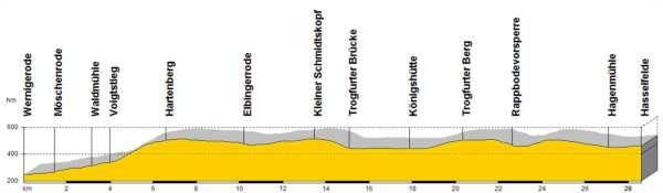

3 Wernigerode Hasselfelde 3

4 Upon arriving in Wernigerode we leave behind the plain having gained very gradually a higher altitude, and from now on we shall gain an even greater altitude gradually up to the plateau at the foot of the Brocken, still below the 500 m of altitude. This means that our uphill progress will be barely perceived. We begin to walk along the valley along the left slope of the Zillerbach, a tributary of the Holtemme, still through the forest, which will accompany us for this whole stage. We leave the town along the Marktstrasse, we turn left on the Johann Sebastian Strasse, on the right we take Noschenroder Strasse and will continue along the Muhlental which we leave 500 m on. We turn left on the Am Vogeisang, and finally on the right on the Pisseckeweg; on for about 5 km where we leave the river and the footpath to cross the 244 4

5 Here we take the Voigtstieg which on passing from a river to another, we follow for over 3 km; being very watchful about crossroads on the right and left we arrive at the crossroad with the K1347, 5

6 which we cross keeping the same direction, but after 200 m we shall turn right on the path that first skirts the wood, then crosses the meadows and fields, goes over a stream and we arrive at Elbingerode, part of the municipality of Oberharz am Brocken, 500 m above sea level. We are now on the Harz plateau 6

7 and enter the village walking along the Bleichenkopf, we follow the Wolfshagen, and over the Rohrbachstrasse we turn on to the Markt or 244, across the Wasserstrasse or 27 and at the next crossroad we turn right on the Karl-Marx-strasse which leads first left and then right, on the Sussenburgerstrasse 7
.")
8 Here we turn left and follow this direction for 500 m. At the crossroad we turn left and keep the same direction for 500 m. At the crossroad we continue straight on uphill to the top of the hill (here, on our right, we will find one of the largest stone quarries in Germany). Through the quarries area, we turn right, then left and we will be on a cart track in open countryside 8

9 and enter a woodland, then we arrive in the valley of the river Bode, precisely at a point where there is a dam which we cross and turn right along the road that skirts the reservoir up to the village of Konigshutte

10 Before entering the village we turn left along the road that first skirts the forest, then for more than 6 km of meadow, after a gentle hill we descend and approach a second artificial reservoir on the river Bode meadow and here we gradually descend approaching a second reservoir on the river Bode, on the right, then left 10

11 As we arrive at the dam we cross and turn right, then immediately left and return to walk through forests and meadows, first going gently uphill, then downhill until we arrive at a road junction coming from the right. This takes us to the end of the stage Hasselfeld, 500 m above sea level, in 2 km. Here we enter by the Hagenstrasse, then on the left the Breite Strasse. 11

12 Hasselfelde 12
Slad over to Pitchcombe and back
 The walk climbs up from Slad over Wickridge Hill, descends to near Pitchcombe, then climbs back over Wickridge hill and round the back of Slad. Page 1 Start Point: SO 8718 0732 The Woolpack, Slad Length:
The Mendip Way. Route Directions and Maps Uphill to Wells
 The Mendip Way Route Directions and Maps Uphill to Wells Website: www.mendiphillsaonb.org.uk Email: mendip@mendiphillsaonb.org.uk Facebook & Twitter: @MendipHillsAONB Phone: 01761462338 1 Uphill to Loxton
Pontfadog. Walk A. Walk A
 Walk A A Bird s eye view of the village 2km. (1 1 /2 miles); height gain 45m. (150ft) about 45 minutes. Six minutes walk along the main road towards Glyn Ceiriog reach a signpost to Llwynmawr. Take the
Ardingly Lake, Ouse Valley, Borde Hill
 point your feet on a new path Ardingly Lake, Ouse Valley, Borde Hill Distance: 14 km=9 miles or 12½ km=8 miles Region: West Sussex Author: Hautboy Refreshments: Borde Hill Map: Explorer 135 (Ashdown Forest)
A Tour of the Valle del Gizio
 Walk 25 A Tour of the Valle del Gizio Walking time 5hrs 30mins (4hrs if Colle Mitra is omitted) Difficulty 2 (likely to be snowbound in winter months); 1 (if Colle Mitra is omitted) Ascent/descent 570m/570m
BISHOPSTONE CIRCULAR WALK
 BISHOPSTONE CIRCULAR WALK 4½ miles (7¼ km) - allow 2 hours (see maps on final pages) Introduction This walk is within the North Wessex Downs Area of Outstanding Natural Beauty and starts from the small,
HARDMOORS ROUTE DESCRIPTION
 HARDMOORS 60 2016 ROUTE DESCRIPTION RACE START (GUISBOROUGH) - CHECKPOINT 2 (SALTBURN) DISTANCE 9 MILES CUT OFF TIME 1030 GRID REF OS 666 208 1. Leaving the Sea Cadets Hall, turn left onto the road and
Mersey Valley Timberland Trail
 Route Pack Page 1 Route Summary A long distance linear walk on roads and country paths linking town and countryside to parks, woodlands and other open spaces. Grade Distance Accessibility Allow Start Map
Ystwyth and Rheidol Bridleway Routes. Route 2:Llanilar Circular
 Ystwyth and Rheidol Bridleway Routes Route 2:Llanilar Circular Route overview and terrain: A long circle using connecting ridges with fine views to link the Rheidol and Ystwyth river valleys. The route
Lewes and the South Downs
 point your feet on a new path and the South Downs Distance: 0 km=1½ miles moderate walking with long easy stretches Region: East Sussex Author: Hautboy Refreshments: Date written: 8-apr-013 Map: Explorer
HARDMOORS 55 RACE ROUTE 2018 HELMSLEY - GUISBOROUGH
 HARDMOORS 55 RACE ROUTE 2018 HELMSLEY - GUISBOROUGH HELMSLEY - CHECKPOINT 1 (WHITE HORSE) 1. Leave RACE START, continue ahead on road (Baxtons Sprunt) At crossroads turn right down Canons Garth eventualy
Aston Rowant Discovery Trail
 The walk was developed by Aston Rowant Parish Council. The Trail is stile-free and fully way-marked. The circular route is 5.3m but with the extension to a pub and hotel 6.2m. Key Main Aston Rowant Discovery
Vipiteno/Sterzing STAGE 2 VIPITENO BRESSANONE. Km 32,7 +400m -780m E. Italia. Trentino-Alto Adige. Bolzano
 Vipiteno/Sterzing Italia Trentino-Alto Adige STAGE 2 VIPITENO BRESSANONE Km 32,7 +400m -780m E Bolzano Vipitenum was a Roman mansio on the Brenner Road at 948 m of altitude, which between the 9th and 11th
Baggy Point, Croyde, North Devon
 Baggy Point, Croyde, North Devon A walk using the South West Coast Path that is likely to be suitable for people with impaired mobility or with a pushchair, wheelchair, or mobility scooter. The Coast Path
CWMGIEDD FROM ABERCRAVE
 Abercrave to Cwmgiedd Walk Page 1 Starting from The Abercrave Inn. Grid Ref: SN 824128 From the Abercrave Inn, an 11.3km (7 miles) walk to the foothills of the Cribarth Mountain, then through forest to
Hay Wood, Rowington and Baddesley Clinton - Warwickshire
 Hay Wood, Rowington and Baddesley Clinton - Warwickshire Starts at Lay-by alongside Hay Wood 2 hours 30 minutes 5.5miles 8.8km Leisurely ID: 0.683 Developed by: John Clift Checked by: Andy Page www.ramblersroutes.org
Germany's Mountains and heritage railways
 Harz Mountains & Rhine Gorge 2015 Germany's Mountains and heritage railways From 1,295 per person Discover two of Germany's most picturesque regions on this fantastic two-centre holiday. We explore the
Wicklow Mountains Path Survey
 Wicklow Mountains Path Survey Ballinacor Croaghanmoira Fananierin Start to Finish: T 11723 86602 to T 11175 89057 Altitude (lowest highest): 385m 664m Weather: Hot Access: Coolgarrow forest entrance Surveyed
Hindhead, Keffolds Copse and Gibbet Hill
 point your feet on a new path, Keffolds Copse and Gibbet Hill Distance: 6 km=4 miles Region: Surrey Author: Schwebefuss Refreshments: Punch Bowl Café moderate walking Date written: 14-apr-2015 Last update:
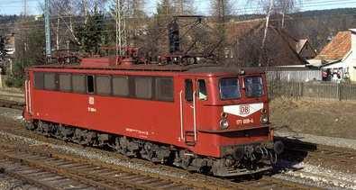
SWITZERLAND BY RAIL. TRAINS MAGAZINE TOUR September 12-23, 2019 Wernigerode, Germany Extension September 23-27, Itinerary
 SWITZERLAND BY RAIL TRAINS MAGAZINE TOUR September 12-23, 2019 Wernigerode, Germany Extension September 23-27, 2019 Itinerary Switzerland by Rail 2019 Travel with TRAINS Magazine and Special Interest Tours
CARCASSONNE TO BARCELONA CYCLE
 FRANCE, SPAIN CYCLE TOUGH ABOUT THE CHALLENGE This challenging, spectacular ride takes us from the beautiful fortified city of Carcassonne, through the rolling hills of Cathar country before reaching the
beach. Make the ford and follow the trail out to the junction with Red Creek Tr in an open grassy area.
 Description: This is a moderate to slightly strenuous 22.8 mile backpack (add 2.6 miles if you do the packless out and back to the Lion s Head) that will have you exploring nearly every thing that is The
PLACES TO VISIT FROM SAN FRANCISCO, 71 IN DISTANCE ORDER (distance and driving times are approximate)
") PLACES TO VISIT FROM SAN FRANCISCO, 71 IN DISTANCE ORDER (distance and driving times are approximate) 1. Rio Chillar 2 km, 4 mins A peaceful walk close to the apartment. The Rio Chillar eventually flows
PLACES TO VISIT FROM SAN FRANCISCO, 71 IN DISTANCE ORDER (distance and driving times are approximate) 1. Rio Chillar 2 km, 4 mins A peaceful walk close to the apartment. The Rio Chillar eventually flows
Torrance. Mapped Heritage. The following maps demonstrate the spatial strategy for the Torrance trails. Trail themes
 Torrance The following maps demonstrate the spatial strategy for the Torrance trails. The heritage and proposed trails are presented on two maps per area: Map 2A - Existing heritage locations Map 2B -
Answers to Your Turn. Chapter 2. Maps and mapping
 Geog. 1 Answers to Your Turn Chapter 2. Maps and mapping Chapter 2.1 Mapping connections 1. A = Isle of Man; B = Northumberland; C = Cornwall; D = Surrey; E = Shrewsbury; F = Nigeria; G = Japan; H = China;
Bewl Water & the High Weald
 1 Bewl Water & the High Weald Stonegate station - Stonegate - Wallcrouch - Newbarn - Cousley Wood - Wood's Green - Wadhurst station Length: 9 ½ miles (15.3km) Underfoot: Large portions of this path are
For more information and to buy this book click here ISBN: CICERONE. Guides for walkers, trekkers, mountaineers, climbers and cyclists
 For more information and to buy this book click here ISBN: 9781852844103 CICERONE Guides for walkers, trekkers, mountaineers, climbers and cyclists www.cicerone.co.uk SALÈVE AND VALLÉE VERTE SALÈVE WALK
PHOENIX PARK INCORPORATING THURNSCOE COMMUNITY WOODLAND
 PHOENIX PARK INCORPORATING THURNSCOE This popular site is known for its sculptures and climbing wall which can be seen as you meander around the park. Walking towards the top of the woodland you will pass
This path goes past an old tree nursery and sawmill. After 800m it crosses over a lane. Follow the bridleway fingerpost into the woods.
 FRENSHAM PONDS 11K CIRCULAR TRAIL 2½ HRS GU10 2DA This magnificent heathland trail starts in woodland and then brings you out onto the open heather of Frensham Common, with no roadwork! The route runs
The Hundred Parishes
 The Hundred Parishes Walks from railway stations number 3 3 miles (5kms) circular walk from Stansted Mountfitchet Start & finish: Stansted Mountfitchet station. Ordnance Survey Explorer Map 195. Grid Reference:
Chevening and the North Downs
 1 Chevening and the North Downs Dunton Green station - Chipstead - Chevening - Knockholt - Hawley's Corner - Botley Hill - Oxted station Length: 12 ¼ miles (19.7 km) Underfoot: Portions of the walk are
Chess & Gade. Chalfont & Latimer Station - Latimer - Chenies - Sarratt - Kings Langley Station. Length: 8 ¾ miles (14.25km)
") 1 Chess & Gade Chalfont & Latimer Station - Latimer - Chenies - Sarratt - Kings Langley Station Length: 8 ¾ miles (14.25km) Underfoot: Well-trodden paths, mainly firm in all weather conditions, though
1 Chess & Gade Chalfont & Latimer Station - Latimer - Chenies - Sarratt - Kings Langley Station Length: 8 ¾ miles (14.25km) Underfoot: Well-trodden paths, mainly firm in all weather conditions, though
Fetcham Downs and Bocketts Farm A magical teashop walk
 point your feet on a new path Fetcham Downs and Bocketts Farm A magical teashop walk Distance: 3 km=2 miles or 4 km=2½ miles Region: Surrey Author: Fusszweig Refreshments: Bocketts Farm easy walking Date
Dehesa Vieja and the Los Molinos area give us the gift of one of the finest
 ROUTE Dehesa Vieja and the Los Molinos area give us the gift of one of the finest beauty spots in our town. Recent history brings paradoxes: a short time ago, this place that now offers us so much beauty
Penn Common and Bramshaw Wood
 Trail Activity Type Terrain Author Distance Ascent Location : HAMPTR0025 : Walk : Pub : Towpaths and Cycle Tracks : Anne-Marie Edwards : 5.3 miles / 8.5 kms : 381 feet / 116 metres : SU253173 / SP5 2BZ
MOUNTAIN BIKING THE CASCADE LOOP
 MOUNTAIN BIKING THE CASCADE LOOP By Henry Freimuth All photographs by Henry Freimuth The Cascades are on the Spanish Creek, which is a tributary of the Feather River. The Feather River was named by Spanish
C E N T R A L C A T S K I L L S
 120 C E N T R A L C A T S K I L L S Central Catskills Once out of the southern parts of the Catskills, the Long Path enters the more well traveled and civilized regions. The trail joins the Devil s Path,
Walk 1: Highfield, Lob Wood and The River Wharfe
 Walk 1: Highfield, Lob Wood and The River Wharfe Start: The Hen Pen Garden, Main Street, Addingham LS29 0NS, SE 077 498. Alternative Start: Near Bolton Bridge SE 071 525 (see page 6). Full walk: 4.5 miles
Reigate Hill and Gatton Park
 point your feet on a new path Reigate Hill and Gatton Park Distance: 11½ km=7 miles easy-to-moderate walking or 2 walks of 6½ km=4 miles and 5½ km=3½ miles Region: Surrey Author: Schwebefuss Refreshments:
TREK THE ROCKIES ABOUT THE CHALLENGE TREK THE ROCKIES FOR HIGHLAND HOSPICE CANADA TREK DEMANDING
 TREK THE ROCKIES CANADA TREK DEMANDING ABOUT THE CHALLENGE The Canadian Rockies are justifiably world-famous for their magnificent scenery: the combination of impressive, jagged mountains, bright turquoise
Singleton and the South Downs
 point your feet on a new path Singleton and the South Downs Distance: 13½ km=8½ miles easy walking with a few steeper sections Region: West Sussex Author: Hautboy Refreshments: Singleton, Hill Barn Date
Palinuro & the South Coast of the Cilento National Park
 Palinuro & the South Coast of the Cilento National Park The mythical headland of Palinuro and the pristine coast of Camerota TRIP NOTES 2018 Genius Loci Travel, 2017. All rights reserved. INTRODUCTION
Beautiful Walks from the Blue Ball Inn
 Walk No. 5 RIVER VALLEYS AND MOOR Countisbury, Watersmeet, Hillsford Bridge, Cheriton, Shilstone Hill, Rockford and Chiselcombe. 8.5 MILES APPROX. Walking time four and a half hours approx. OS 1;25,000
Trail Phasing Plan. Note: Trails in the Clear Creek Canyon area (Segments will be finalized in the future to minimize wildlife impacts
 Note: Trails in the Clear Creek Canyon area (Segments 2 5 and a future JCOS connection) will be finalized in the future to minimize wildlife impacts Trail Phasing Plan P Parking 3 Easy Trail Intermediate
Tenerife Sur: Short Walks Under 10 km. Cabo Blanco - La Camella Circular (Arona) Route Summary. Route Overview. Description
 Route Summary. Route Overview. Description") Tenerife Sur: Short Walks Under 10 km Cabo Blanco - La Camella Circular (Arona) Route Summary An interesting town and country walk, with some marvellous views, in a well-populated residential area close
Tenerife Sur: Short Walks Under 10 km Cabo Blanco - La Camella Circular (Arona) Route Summary An interesting town and country walk, with some marvellous views, in a well-populated residential area close
Leaden Boot Challenge ROUTE INSTRUCTIONS
 Leaden Boot Challenge ROUTE INSTRUCTIONS Section 1 Alstonefield to Ilam From the village hall car park turn R then L and pass through the village keeping to the R to enter Church Street. Pass the Church
A Circular Walk from Chapel Carn Brea
 A Circular Walk from Chapel Carn Brea 4.3 Miles A Walk Visiting Five Historic Ancient Sites This circular walk offers the possibility of several alternatives, depending on the walker s available time and
RIVER AMENITY PLOT TITLE NO: ON F BRIDLEPATH F GORING ON THAMES F OXFORDSHIRE.
 RIVER AMENITY PLOT TITLE NO: ON133796 F BRIDLEPATH F GORING ON THAMES F OXFORDSHIRE www.warmingham.com RIVER AMENITY PLOT TITLE NO: ON133796 F BRIDLEPATH F GORING ON THAMES F OXFORDSHIRE Goring Railway
Marilla Reservoir to Chestnut Ridge via Marilla Trails and Bullis Hollow Trail east to west
 USGS topographic maps useful to this hike are the Bradford and Stickney 7.5 minute sectionals. These notes are designed to assist in identifying distance and location using geophysical and man-made characteristics
COSTA BLANCA MOUNTAIN WALKERS - WALK DESCRIPTION. Visit for more walks descriptions in Spain
 Visit www.walksinspain.org for more walks descriptions in Spain Walk description originally prepared by:- Ralph Phipps Last Updated 15 th July 2016 Title of Walk Location of Start (include name of nearest
Girrakool to Wondabyne station via Pindar caves
 Girrakool to Wondabyne station via Pindar caves 7 hrs 30 mins 18.1 km One way Experienced only 5 741m This walk starts from the Girrakool picnic area and winds south, following Piles creek into the Brisbane
Leaden Boot Challenge 2016 ROUTE INSTRUCTIONS
 Leaden Boot Challenge 2016 ROUTE INSTRUCTIONS Section 1 Alstonefield to Ilam (CP2) From the village hall car park turn R then L and pass through the village keeping to the R to enter Church Street. Pass
Darwin s gigantic blunder
 Trail Darwin s gigantic blunder Explore how ice shaped the landscape and why Charles Darwin made a nice mess of Glen Roy Time: 1hr 10 mins Distance: 2 miles Landscape: rural At Glen Roy a curious feature
Woodland Walk If you enjoyed this walk there are two others available in the same area.
 The Woodland Walk 11-12 kilometres (7-8 miles) 4-5 hours Terrain: some easy hills Can be slippery when wet 5 stiles Unsuitable for a pushchair/wheelchair Uses OS map 197 Parking: Pulborough Station and
The Clyde Walkway. Cambuslang Bridge to Strathclyde Country Park. Thanks to
 Thanks to The Clyde Walkway is a partnership venture based on co-operation and agreement. North Lanarkshire, South Lanarkshire and Glasgow City Councils would like to acknowledge the help and support of
CARCASSONNE TO BARCELONA CYCLE
 FRANCE, SPAIN CYCLE TOUGH ABOUT THE CHALLENGE Our route takes us through the tiny mountainous country of Andorra, where our main challenge lies in the long twisting climb of the Port d Envalira (2408m),
The Prince Henry Cliff Walk
 The Prince Henry Cliff Walk 3 hrs 30 mins 6.8 km One way Moderate track 3 575m Going from Katoomba to Leura, this walk covers the top of the cliff line and most of the major lookouts. With brilliant vistas
BURGHCLERE PARISH RIGHTS OF WAY
 BURGHCLERE PARISH RIGHTS OF WAY Full descriptions compiled by Neill & Miggie Bruce All photos Miggie Bruce FP23 on Ridgemoor, looking south, with FP22 crossing by the bush FP1. From C183 Aldern Bridge
Skiing and Snowshoes on Un-groomed Fernan Saddle Terrain
 Skiing and Snowshoes on Un-groomed Fernan Saddle Terrain Three ski or snowshoe routes are available from the Fernan Saddle Parking Lot which either do not cover routes ordinarily groomed for snow machine
Approximate distance: 7.5 miles For this walk we ve included OS grid references should you wish to use them.
 Approximate distance: 7.5 miles For this walk we ve included OS grid references should you wish to use them. 6 5 7 8 4 1 2 Start End N 3 W E S Reproduced by permission of Ordnance Survey on behalf of HMSO.
3.1 Bowness-on-Solway to Carlisle
 3.1 Bowness-on-Solway to Carlisle Map panel 1 Distance 15 miles (24 km) Terrain minor roads, tracks, field paths and riverside footpath, muddy in places Grade easy, with gentle gradients on undulating
Telluride-to-Moab Alternative Singletrack Options
 Telluride-to-Moab Alternative Singletrack Options Day 1 Day 1 Alternate 1: Galloping Goose to Deep Creek. 18.4 miles, ascent 3,530ft, descent 1,388ft. This is fun, flowey, moderate to intermediate singletrack
Description for the Round Rotherham 8 December 2007
 Directions: L left R right ½L, ½R half left, half right X cross X Rds cross roads SA straight Codes: BR bridge FP footpath FB footbridge RWY railway CP car park RD road Description for the Leave Event
The Sudbury Branch Walks 1-4
 The Sudbury Branch Walks 1-4 Sudbury Branch Walks From Sudbury to Marks Tey The gentle declivities, the luxuriant meadow flats sprinkled with flocks and herds... the sound of water escaping from the mill
Wicklow Mountains Path Survey
 Wicklow Mountains Path Survey Glenmacnass Tonelagee Start to Finish: O 114 030 to O 085 016 Altitude (lowest highest): 370m 817m Weather: Sunny day, hot Access: Military Road, Glenmacnass Surveyed by:
Ranmore Common and Polesden Lacey
 point your feet on a new path Ranmore Common and Polesden Lacey Distance: 9½ km=6 miles Region: Surrey Author: Fusszweig Refreshments: Polesden Lacey easy walking Date written: 20-dec-2016 Last update:
Beamers Trail. Walk No.1. 6 miles. (easy with some moderate ascents and descents)
") Beamers Trail Walk No.1 6 miles (easy with some moderate ascents and descents) 1 BEAMERS TRAIL 6 miles (easy with som WALK The Warpers Trail forms part of the long distance Witton Weavers Way. This is
Beamers Trail Walk No.1 6 miles (easy with some moderate ascents and descents) 1 BEAMERS TRAIL 6 miles (easy with som WALK The Warpers Trail forms part of the long distance Witton Weavers Way. This is
Hadleigh Castle and Chalkwell Oaze
 1 Hadleigh Castle and Chalkwell Oaze Benfleet station Hadleigh Park Hadleigh Castle Leigh-on-Sea Chalkwell station A short stroll through the lush woods of Hadleigh Park high above the Thames-side marshes,
IBG SPRING WORKCAMPS 2018
 IBG SPRING WORKCAMPS 2018...peacing the world together Code Name Region Dates Type Vols IBG 01 Schillingen Rhineland-Palatine 14.03.-28.03. RENO/FEST 10 IBG 02 Grafenhausen Baden-Wurttemberg 07.04.-21.04.
Self-Guided Walk Langdale Pikes. Start & Finish: NT car park (free to members) at Sticklebarn - on the right just beyond the New Dungeon Ghyll hotel.
 at Sticklebarn - on the right just beyond the New Dungeon Ghyll hotel.") Self-Guided Walk Langdale Pikes Key Information These mountains form a collection of spires and cliffs on the north side of Langdale. This walk visits four of the main tops Pavey Ark, Harrison Stickle,
Self-Guided Walk Langdale Pikes Key Information These mountains form a collection of spires and cliffs on the north side of Langdale. This walk visits four of the main tops Pavey Ark, Harrison Stickle,
CUSERCOLI TAPPA 26 - CUSERCOLI - SANTA SOFIA CIVITELLA DI ROMAGNA KM 20,5/23, E. Emila Romagna Comune: di Civitella di Romagna Forlì-Cesena
 CUSERCOLI Emila Romagna Comune: di Civitella di Romagna Forlì-Cesena TAPPA 26 - CUSERCOLI - SANTA SOFIA KM 20,5/23,5 +680-550 E CIVITELLA DI ROMAGNA Originally the settlement of Cusercoli was enclosed
MULETA - TOSSALS VERDS
 GR 221 - MULETA - TOSSALS VERDS The route takes in the valley of Sóller, the barranc, or ravine, de Biniaraix, the Ofre, Cúber and Almallutx valleys, and links the Muleta refuge with that of Tossals Verds.
The four Dales Challenge
 I walked for Breast Cancer Now last year with Walkwise and the team were fantastic; looking out for the group and providing support and encouragement for myself and my friends. If you choose to come on
TAPPA 38 FICULLE - ORVIETO
 FICULLE Umbria Terni TAPPA 38 FICULLE - ORVIETO km24,8 +530-630 E The origins of Ficulle go back to Etruscan times, as shown by the caves of the Madonna della Maestà, with archeologists believe them to
Gomshall station - Abinger Hammer - Abinger Common - Friday Street - Leith Hill - Coldharbour - Holmwood station
 1 To Leith Hill Gomshall station - Abinger Hammer - Abinger Common - Friday Street - Leith Hill - Coldharbour - Holmwood station Important note: this walk cannot currently be done wholly by train on a
The Cotswolds Challenge
 The Cotswolds Challenge Friday 28 Sunday 30 September 2018 Following its overwhelming success, we are repeating the original Cotswolds Challenge. This two day, 24 mile challenge explores good paths and
GRINDLEFORD GALLOP 2018
 GRINDLEFORD GALLOP 2018 Route Information The Grindleford Gallop follows a fixed 21 mile route through the lanes and paths of Derbyshire. All competitors must follow this route. An OS map of the area with
Key Information. Self-Guided Walk Corfe Castle to Swanage
 Self-Guided Walk Corfe Castle to Swanage A classic walk from the pretty village of Corfe Castle. Enjoy extensive views whilst walking along the wide ridge to the popular seaside town of Swanage, returning
walking
 Two Castles Trail Meander through rolling countryside full of history on this 24 mile waymarked walking route between Okehampton and Launceston Castles www.devon.gov.uk/ walking www. dartmoor.co.uk www.
ID: 283 Distance: 6.2 miles Height gain: 500 Metres Map: Explore OL 19 Contributor David and Chris Stewart
 Walkingworld Wild Boar Fell ID: 283 Distance: 6.2 miles Height gain: 500 Metres Map: Explore OL 19 Contributor David and Chris Stewart Features Birds, Great Views, Hills or Fells Description: Wild Boar
Brenig Archaeology Trail
 Walk Information: Maps: OS Explorer 264 Distance: 2.5 miles / 4 kilometres Duration: Allow 2.5 hours for the circular walk Difficulty: easy. Well-marked trail over fields. Start and finish: SH 98325741
San Miguel to Caserio de la Hoya Circular (San Miguel)
") Tenerife Sur: Short Walks Under 10 km San Miguel to Caserio de la Hoya Circular (San Miguel) Route Summary An informative and scenic walk back in time from San Miguel to below El Roque, overlooking the
Tenerife Sur: Short Walks Under 10 km San Miguel to Caserio de la Hoya Circular (San Miguel) Route Summary An informative and scenic walk back in time from San Miguel to below El Roque, overlooking the
TAPPA 37 CITTA DELLA PIEVE FICULLE
 CITTA DELLA PIEVE Umbria Perugia TAPPA 37 CITTA DELLA PIEVE FICULLE KM 21,7 + 320-200 E The origins of Città della Pieve are still unknown. Documents dated back to 1000 call it Castrum Plebis S. Gervasi.
San Luis Obispo. Bishop Peak Felsman Loop Eagle Rock Maino Open Space Poly Canyon Poly P Other Areas
 San Luis Obispo Bishop Peak Felsman Loop Eagle Rock Maino Open Space Poly Canyon Poly P Other Areas 1 JCT. ELEV. 72 400 00 0 FELSMAN LOOP GATE LOOP RIDGE 600 FENCE JCT. ELEV. 860 1000 1200 BISHOP PEAK
day Guided Bike Tour Itinerary
 2018 8-day Guided Bike Tour Itinerary Windsor, Stratford, Cotswolds, Blenheim Palace, Oxford, Downton Abbey, Stonehenge, Bath Duration Start Finish 8 days / 7 nights London (London Paddington Railway station)
Spaces are very limited- Book Soon! Dates: May 19-30, 2020 May 22- Jun. 2, 2020 May 24- Jun. 4, 2020 May 26- Jun 6, 2020
 Alpine Explorer & the Glacier Express Train with Oberammergau Passion Play From $4,999* pp 12 Days 18 Meals *Rate is per person, land only, double occupancy, tour inclusions and available options may vary
Hiking Trail Descriptions
 Hiking Trail Descriptions For ye shall go out with joy. And be led forth with peace. The mountains and the hills shall break forth before you in singing. And all the trees of the fields shall clap their
NEPAL LANGTANG TREK ABOUT THE CHALLENGE NEPAL TREK TOUGH
 NEPAL TREK TOUGH ABOUT THE CHALLENGE This magnificent trek, with the ultimate combination of spectacular scenery and fascinating culture, takes us to the magnificent Langtang region of the Himalayas, open
The City of Tomar is a medium-size city in central Portugal, beautifully located on the banks of
 Tomar The City of Tomar is a medium-size city in central Portugal, beautifully located on the banks of the river Nabão, whichh gives its name to the city s inhabitants, the Nabantinos. With about 43 000
Trail Assessment Report
 Trail Assessment Report Trail Options for the Bear Creek Canyon located in Pikes Peak Ranger District, Pike National Forest and on Colorado Springs Utility Lands Due to the presence of a unique species
Stage 2: Following the royal cattle route towards the medieval castle of the Mendozas. Tres Cantos to Manzanares el Real
 Stage 2: Following the royal cattle route towards the medieval castle of the Mendozas. Tres Cantos to Manzanares el Real 25,1 km, 6,5 hrs, é513m, ê344m, ñ661-1008m 0,0 km ñ745m Tres Cantos tvsäã 0,9 km
RIVER ZADORRA, between Ibaiondo and Gobeo RIVER ZADORRA, FROM GAMARRA MAYOR TO ABETXUKO FROM THE CITY TO THE COUNTRYSIDE ALONG THE RIVER
 RIVER ZADORRA, FROM GAMARRA MAYOR TO ABETXUKO PRACTICAL INFORMATION TIMETABLE OF THE URARTE VEGETABLE GARDENS Winter timetable (from 1st October to 31st March): from 08:30 to 18:15 Summer timetable (from
Km point Height Landmark Description 0 km m. Ordino. 3,5 km m. La Cortinada. 5 km m. Llorts. 10 km m.
 Organisation 0 km 1.280 m Ordino Starting from the centre of town along with by enchanting music and fireworks. We are surrounded by a crowd admiring our courage. It is the beginning of an unforgettable
Positano the best walks
 Positano the best walks Walking behind the scenes of the world s most beautiful resort town including the complete Sentiero degli Dei TRIP NOTES 2018 Genius Loci Travel, 2018. All rights reserved. INTRODUCTION
Tour Of Tameside The alternative tameside trail
 Tour Of Tameside The alternative tameside trail A 30 mile walk around the borough of Tameside taking in the Valleys of the Medlock, Etherow and Tame. The whole walk can be completed in one day by anyone
South of the Village Centre
 Trumpington History Trails South of the Village Centre Changes on the South Side of Trumpington Since the 19th Century 3 Walk or cycle 3.6 miles/5.8 kms walk on pavements and footpaths; cycle on roads
Scenic Railway to Ruined Castle
 Scenic Railway to Ruined Castle 7 hrs 30 mins 12.4 km Return Hard track 4 963m This is a very popular, full day walk, in the Katoomba Area, offering great views of the valley. The walk follows the edge
The rewards more than make up for the efforts of seeing the country this is a truly unforgettable trek.
 MADAGASCAR TREK ORANGE 2 ABOUT THE CHALLENGE This exciting trek takes us to remote Madagascar, where spectacular scenery and amazing wildlife awaits! From canyons and gorges to bush-covered plains and
TREK SRI LANKA ABOUT THE CHALLENGE SRI LANKA TREK ORANGE 1
 SRI LANKA TREK ORANGE 1 ABOUT THE CHALLENGE Little can rival Sri Lanka s variety. From paddy fields, high grasslands and emerald-green tea estates, to dense forest and golden tropical beaches, this Island
Beautiful Walks from the Blue Ball Inn
 Walk No. 2 WINSTONS WALK Countisbury, Wind Hill, Watersmeet, Ash Bridge and Winston s path. 5 Miles approx. Walking time- Two and a half hours approx. (Not including Breaks) OS 1:25,000 Sheet 64/74 Lynton