JSSD AREA C FORECLOSED LAND
|
|
|
- Mitchell Gibson
- 6 years ago
- Views:
Transcription

1 FORECLOSED LAND EXCLUSIVE LISTING WASATCH COUNTY, UTAH ASPENS CHRISTENSEN CUMMINGS TOTAL DENSITY,344 ERUs for,384 Units 550 ERUs 5 ERUs,04 ERUs CONNECTIONS,384 ERUs 400 ERUs 05 ERUs,989 ERUs TOTAL ACREAGE,335 Zachary Hartman zhartman@landadvisors.com 443 North Business Park Loop Road, Suite, Park City, Utah ph The information contained herein is from sources deemed reliable. We have no reason to doubt its accuracy but do not guarantee it. It is the responsibility of the person reviewing this information to independently verify it. This package is subject to change, prior sale or complete withdrawal. UTWA7-.0.7
2 TABLE OF CONTENTS Surrounding Development Map Page 3 Entitlement Agreement Summary Page 4 Jordanelle South Area Map Page 5 Property Overview Page Location Overview Page 7 Utah Economy Page 9 Property Area Maps Page History Page 5 Boundaries Survey Page Property Photos Page 7


3 SURROUNDING DEVELOPMENT MAP Zachary Hartman East Park Mayflower North Empire PassAB 4 Bonanza Flats Deer Valley Snow Park at Deer Valley Deer Crest Pioche Mountain Estates Mayflower Deer Cove Stillwater AB 39 Mayflower Lakeview State Trust BLM J o r d a n e l l e R e s e r v o i r Hideout Jordanelle State Park AB 3 Tuhaye AB 48 Inholdings Held by Third Parties Summit County Wasatch County State Wildlife Reserve/ Management Area Subject AB50 Kamas AB 35 Francis Pine Cany onrd 40 Victory Wasatch Mountain State Park Legend Projects Active Conceptual Future K Mile UTWA While Land Advisors Organization makes every effort to provide accurate and complete information, there is no warranty, expressed or implied, as to the accuracy, reliability or completeness of furnished data. This information can not be reproduced in part or whole without prior written permission. Land Advisors Organization
4 ENTITLEMENT AGREEMENT Snell & Wilmer L.L.P. TO: Zachary Hartman, Land Advisors Organization FROM: Snell & Wilmer L.L.P. DATE: November, 0 RE: Summary of Entitlement Agreement for Aspens, Christensen and Cummings Developments ENTITLEMENT AGREEMENT SUMMARY Full Title: Entitlement Agreement for Aspens, Christensen and Cummings Developments Recording Info: October, 0, Entry No , Wasatch County, Utah Effective Date: August 30, 0 Parties: Jordanelle Special Service District and Jordanelle Special Service District Special Improvement District No (collectively JSSD) Wasatch County ( County) USAA Mutual Funds Trust, Wells Fargo & Co, and Koch Financial Company UMB Bank ( Trustee) Land: Aspens, Christensen, and Cummings properties ( Settlement Area). See Exhibit A. Settlement Area Vested Uses, The Settlement Area properties are vested with certain uses, densities, and configurations, set forth in Section 3 of the Agreement in full and summarized here: Densities, and Configurations: Aspens Christensen Cummings TOTAL Density 344 ERUs 550 ERUs 5 ERUs,04 ERUs for 384 Units Connections* 384 ERUs 400 ERUs 05 ERUs,989 ERUs *The right to connect to water and sewer improvements, including the right for an ERU to connect to capacity with the JSSD Water Treatment Facility Density Allocation/ Master Plan Amendments: Future Approvals: Talisman Phase I Plat Approval: Partial Sale Water Reservation: Impact Fees: As portions of Settlement Area are sold, Trustee may allocate the approved Density ERUs and ERU Connections from and to the Settlement Area properties in proportion to the amount of developable property as represented in the approved master plan. The allocation must be stated in a Notice of Density Allocation delivered to the County before such conveyance. The County s staff will inform the Trustee whether an application to amend an existing master plan(s) is required before allocation approval. Each approved Notice of Density Allocation or Notice of Master Plan Amendment must be included in the form of Amendment of Entitlement Agreement (see Exhibit D) and recorded on both the conveyed and remainder parcels. Until August 9, 00, the County will review future development plans subject to the terms of the Entitlement Agreement and the County Code in effect on August 30, 0. The County has given final plat approval for Talisman Phase I within the Aspens development, which will remain and not expire unless an underlying land owner seeks to have the plat vacated or amended. A developer interested in purchasing less than all of the Settlement Area should plan to make an offer for land and the number of Density ERUs and Connections that it may desire. For the first two years (two-year period ending August 9, 08), JSSD has committed water for 989 ERUs. A developer may enter into an agreement with JSSD to reserve a portion of JSSD s existing water rights and source capacity. See form attached as Exhibit C. Developers of the Settlement Area are subject to County impact fees, but JSSD will not charge any impact fees or assessments to the Settlement Area or a developer where such fees relate to the water and sewer improvements or rights to connect to and use such improvements Table of Contents
5 WDL WDL STICHTING MAYFLOWER RECREATIONAL FONDS STICHTING MAYFLOWER MOUNTAIN F 800 UTAH STATE OF BUREAU OF LAND MANAGEMENT UTAH PARKS & RECREATION THE STICHTING MAYFLOWER MOUNTAIN F 3 STICHTING MAYFLOWER MOUNTAIN F VENTANA PROPERTIES STICHTING MAYFLOWER MOUNTAIN F DEER SPRINGS PARTNERS STICHTING MAYFLOWER MOUNTAIN F STICHTING MAYFLOWER RECREATIONAL FONDS THE WASATCH COUNTY SCHOOL BUREAU OF LAND MANAGEMENT MOUNTAIN RESORT HOLDINGS MOUNTAIN RESORT HOLDINGS SPECIAL SERVICE DIS SPECIAL SERVICE DIS SPECIAL SERVICE DIS SPECIAL SERVICE DIS SWEET BRUCE D AKA 5 7 -C 5-F 0-3A 3-F -3F 5-D 5-3F - 9-B 3-3D B 7-E 54 -C 8-F 5 5-3A A POD 5 7-B A EASEMENT C -E 9 9-C 3-F 70 7 JORDANLLE RIDGE NORTH HOA INC SIGGARD RICHARD & LENORA (JT) HOLT MARY VERDELL TAYLOR TR RIDGE INC RIDGE INC NORTH VILLAGE DEVELOPMENT JOHNSON CAROL W TR MORRIS ROBERT A SR ETAL TR N WEST HOLDINGS OLSON NEIHART INC WEST WEST WEST HOLDINGS MORRIS ROBERT A ETAL TR G E OLSON CORPORATION HOLDINGS HOLDINGS HOLDINGS HOLDINGS FINNEY ANNA LOU TR STATES OF MUSTANG POD 3B OPEN 44 MUSTANG POD 3C EASEMENT 0 43 DEVELOPMENT DEVELOPMENT R R9 R8 R R5 R4 R R EASEMENT R0 R R8 R DUNLAP ROBERT W HOLDINGS 700 DUNLAP ROBERT W & KATHY L CITY DUNLAP ROBERT W & KATHY L HILL RICHARD A TR HOLDINGS STATES OF CARLISLE STEVEN R DUNLAP ROBERT W & KATHY L CALLOWAY BERNELL N TR FAULKNER NICK & KARYL HOLDINGS HOLDINGS HOLDINGS CITY 00 PROCIDA JOSEPH TR HOLDINGS CITY HOLDINGS 500 3N3 3N4 CUMMINGS DAVID PROCIDA JOSEPH TR WILSON EARL R TR 7N5 3N 7N 7N 7N3 7N4 7N 8S04 REDUS PARK CITY CITY 8SOS 800 3N 7NOP 7N5 7N7 S TR 8S03 3NOS 3N 7NOP PROCIDA JOSEPH TR GOLF REDUS PARK CITY LABRUM SHERRIE A TR KANG JAMES CNZ LC 7N4 7N8 GOLF 3N3 7N9 3N9 7N3 8S0S 8S0 8S0 7N 3N8 7N0 3N4 7N 3N5 TP 3 3N0S TP3 3N OPEN CHEN THOMAS C WALLACE SEAN R PROCIDA JOSEPH TR 9 8 GOLF TP TP4 TP5 CUMMINGS DAVID 4 3N7 TP9 TP0 TP 5 9S TP8 3NS 0 TP0 AIELLO MARIE TP7 9S 9 9S3 TP7 TP OPEN TP TP OPEN ART TP09 5 9S4 TP3 GOLF REDUS PARK CITY HOLDINGS TP5 OPEN GREGG MARK E 0 8 9S5 TP4 TP REDUS PARK CITY B 9S OPEN TANK OPEN 4 TP9 CUMMINGS DOUGLAS R CUMMINGS LAND AND HENLEY LIVESTOCK 9SOS RW RW4 TP07 HOLDINGS A RW5 CITY GOLF B RW 55 7 CITY OPEN 3 RW3 OPEN RW TP0 8 STATES OF CLYDE CRAIG 9 3 RW SHIER MATT REDUS PARK CITY RW8 4 RW9 45 RW0 47 OPEN 3N 3OPN RW3 RW4 OPEN 5 3N MORGAN HILL GROUP CITY REDUS PARK CITY TP3 3N HYANISPORT RANCH RW CITY 37 CITY MOODY LESTER 38 RW TUNNEY HEIDI F TR OPEN N5 4 OPEN S S TP3 4 S5 3N4 S3 S49 S50 S48 CITY TP0 TP03 REDUS PARK CITY HIRST JANNA G FEENEY SEAN E UTAH STATE OF TEACAM G B RILEY MARION R TP33 HOLDINGS STEIN ROBERT GOLF S4 S4 S39 S38 S S47 S S S4 S40 S3 3 S S45 S44 S S4 DRAIN S S34 S0 S5 S7 S9 S TP0 REINSTRA MARK L TR ASSET MANAGEMENT GOLF OPEN TP35 TP34 MOODY LESTER Y TR S5 S N CITY 0 S7 HOLDINGS RC35 HALLAL DAVID GOLF CITY PYROS JEFFREY J 8 S9 S3 S3 3N7 9 S4 S7 S S8 S3 3N9 GOLF S N8 S5 S9 S4 S30 S33 3N0 7 JRD RANCH INVESTMENTS NO JRD RANCH INVESTMENTS NO GARDNER ELBERT W TR 4 3N 4 5 RDS 8 S0 S3 JRD RANCH INVESTMENTS NO N 9 3 SOS 4 CITY HOWES NICK S S HOLDINGS 43 OPEN 3N3 JRD RANCH INVESTMENTS NO N4 GOLF REDUS PARK CITY JRD RANCH INVESTMENTS NO JRD RANCH INVESTMENTS NO N EASEMENT JRD RANCH INVESTMENTS NO 4 CITY 3 OPEN 5 4 SPECIAL 54 SERVICE OPEN GOLF GOLF JRD RANCH INVESTMENTS NO 4 GOLF HOLDINGS 0 GARDNER ELBERT W TR HOLDINGS UTAH STATE OF GARDNER ELBERT W TR GARDNER ELBERT W TR HOLDINGS UTAH STATE OF HOLDINGS 00 VR ACQUISITIONS HOLDINGS HOLDINGS 7000 VR ACQUISITIONS 3 AMD ALLEN JAMES C 33 BOSSART BRENT COOPER ANDREW 9 3A PETERS BRADFORD CAHOON PENNY G TR PARCEL A 3 F J VR ACQUISITIONS VR A 79 CARROLL PATRICK E 94 AMD 9 G PARCEL A H D 78 CHRISTENSEN MOUNTIAN PROPERTIE PATHFINDER 9 AMD VR ACQUISITIONS VR ACQUISITIONS J TR 44 VICTORY RANCH LC AMD WHITTEN TRAVIS P TR KUTZKEY TIMOTHY TR REECE CRAIG D TR 7 75 I 5 54 B CHRISTENSEN MOUNTIAN PROPERTIE VR ACQUISITIONS VR ACQUISITIONS 87 SOUTH AREA MAP Wasatch County Jordanelle South Area - 04 Aerial Zach Hartman LAO ,00,400 3,00 4,000 Feet The boundary lines shown here have been generated for the internal use of Wasatch County and should only be used for general reference purposes. Questions concerning ownership boundary locations should be directed to a title company, attorney, or licensed land surveyor. Wasatch County makes no warranty as to the accuracy or usefulness of this information. The end user of this information assumes all responsibility concerning this information's appropriate use J o r d a n e l l e R e s e r v o i r C 4-D Legend Preliminary Boundary Survey County Boundary Parcel Foot Contour Printed: /7/0 5 Table of Contents


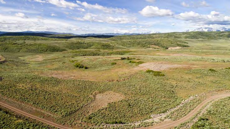
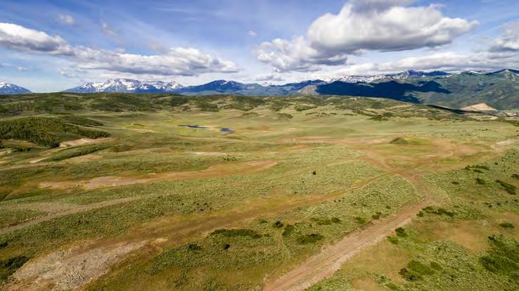
6 PROPERTY OVERVIEW This is an investment opportunity to acquire a site with close proximity to the Jordanelle Reservoir and Park City, Utah. This master planned community is a total of ±,335 acres located on the south Side of Highway 3. The surrounding development includes Victory, Deer Valley, and Tuhaye Golf Community, which are all high end, year-round resort communities. The site is 40 miles from Salt Lake City, 0 miles from world class skiing at Deer Valley Resort, and miles from the Jordanelle Express Gondola at the Mayflower exit. There are panoramic views featuring the Jordanelle Reservoir directly north, Uinta Mountains to the east, and the Wasatch Mountains to the west. ENTITLEMENTS: Equivalent Residential Units (or ERUs) the property is entitled for,04 ERUs. DEVELOPMENTS IN THE AREA: Tuhaye, Victory, Deer Valley, Deer Crest, Mayflower, Stillwater Table of Contents
7 PROPERTY OVERVIEW The Property has a small town feel which is just 0 minutes to Downtown Park City and 5 minutes to Deer Valley Ski Resort. It has panoramic views featuring: The Jordanelle Reservoir, Deer Valley Ski Resort, The Uinta & Wasatch Mountains, The Provo River, and Weber River. This is a four season recreation destination with endless opportunities. This area has become a desirable place to live, work, and visit. LOCATION On the south side of the Jordanelle Reservoir between Victory and Deer Valley. The property is easily accessed from Highway 3 which connects to Highway 40 to the west. This makes for an easy drive to Deer Valley and Park City. SIZE ±,335 acres ELEVATION Elevation is approximately,500 above sea level. CLIMATE Park City s weather in each season make this area a 4 season town. Days are typically sunny, and cooler nights. Average snowfall is 43 inches in town and 400+ inches in the mountains. Summers are cool, dry, and comfortable with an average summer high of 80 degrees. Fall boasts some beautiful colors as tress begin to change. And winter brings some of the best snow on earth. ACCESS The property is accessed from Highway 3. IMPORTANT CONTACTS Utility Suppliers: Electricity: Rocky Mountain Power Gas: Questar Gas Water/ Sewer: Jordanelle Special Service District Telephone/Fiber: All West Communications Wasatch County Planning - Wasatch County Parks and Recreation Table of Contents
8 LOCATION OVERVIEW GATEWAY TO THE UINTAS The Park City and Jordanelle Areas are known for their outdoor recreation. TRAIL SYSTEM The property has room for an extensive trail system for hiking, biking, and snowshoeing. Trails not only provide recreation enjoyment, but also environmental benefits such as: wildlife preservation, water quality protection, storm water management, preservation of vegetation, firebreaks, and a reduction of noise & pollution. WATER SPORTS Enjoy Summer Days out on the water within just a few miles: The Provo River, Weber River, Beaver Creek, and the Jordanelle Reservoir. Activities include: Paddle boarding, swimming, fishing, kayaking, tubing, wakeboarding, waterskiing, boat rentals, and more! BACKCOUNTRY ACTIVITIES Mountain Biking, Hiking, Camping, Horseback Riding, 4x4 ATV Riding, Hunting, etc. WILDLIFE The property is a habitat for mule deer, moose, elk, and many species of birds. GOLFING Park City named the best places to play Between Park City and Heber Valley there are 5 private and public golf courses creating a mountain golf mecca. Combined with breathtaking views, challenging courses, and perfect temperatures, Utah has grown to be a top golf destination. Notable courses include: Red Ledges - a Jack Nicklaus Course Pete Dye and Nicklaus Courses at Promontory Glenwild - a Tom Fazio Course Victory - a Rees Jones Course Gene Bates Course at Soldier Hollow Canyons Golf Course Talisker Golf at Tuhaye - a Mark O Meara Course Crater Springs Jeremy Park Meadows Park City Wasatch Mountain SKIING Utah has 0 world class ski resorts in less than an hour from Salt Lake City International Airport with plenty to do on and off the slopes. Park City Mountain Resort and Canyons Resort have combined through a $50 Million capital improvement plan to create the largest single ski and snowboard resort in the United States. It includes 4 lifts and over 300 trails. The two resorts are connected by the new Quicksilver Gondola. Deer Valley Resort offers a luxurious experience and breath taking views. Deer Valley is a skiers-only mountain with groomed to perfection slopes, limited lift ticket sales, and gourmet dining. They are known for their award winning service on the mountain. 8 Table of Contents
9 UTAH ECONOMY UTAH ECONOMY According to Forbes Utah ranked # in 05 for fastest growing states for Tech Jobs - Adobe, Qualtrics, ebay, Netflix, and Jet.com all have operations in Utah. Utah is the th lowest in the nation for unemployment. Utah is 8th lowest crime rate in the nation BEST STATE FOR BUSINESS -FORBES Utah has the highest birth rate in the nation at 7. per,000 and the lowest median age in the nation. SLC International airport Terminal Redevelopment Program expected to be completed in ,000 sq. ft. additional terminal space. The program is estimated to cost $.8 billion and will be funded by federal grants, user fees, airport revenue bonds, and airport reserves. Utah ranked as top state in the US in job growth in 05. Job growth rate of 3.7% and 49,00 job increase. Non-farm top three industry profiles growth in 05 Information 7.7% = 00 jobs Construction 5.8% = 4500 jobs Hospitality 5.5% = 7,000 jobs Fodor s Travel named Utah top travel destination of the year UTAH MARKET OVERVIEW During 05 Utah led the nation in job growth for seven months and ranked second the remaining five months. Goldman Sachs, Fidelity Investments, and other employers helped Utah earn the reputation as the Wall Street of the West. Utah s construction sector also performed well in 05. Permit authorized construction reached its highest level in eight years and major projects like the rebuild of the Salt Lake City International Airport, a new high rise and performing arts center downtown, and multiple commercial buildings at the nexus of Utah s two largest counties contributed to a strong year. Utah s leisure and hospitality industry also made a solid contribution by adding 7,000 jobs. Park City expanded and created the largest ski resort in the country. This, combined with Utah s Mighty Five national parks, prompted Fodor s Travel to name Utah the top travel destination of the year. Capping it off, Utah s merchandise exports continued to diversify, with 4% year over growth in non-gold exports. - Report to the Governor PARK CITY OVERVIEW The Jordanelle real estate market has been growing rapidly over the past few years. Some influences include: The planned Deer Valley Expansion at the Mayflower Exit huge economic driver for the region: more ski lifts & runs, additional parking, expanded base area, etc. Vail Resorts combined Park City Mountain & Canyons Resort to make the largest ski resort in North America. In 05 Vail started a $50 million transformation in this area. Click to view the Economic Profile for Tourism in Park City & Summit City, Utah. The New SLC Terminal Redevelopment Program Arriving in Table of Contents
10 METRO MAP Zachary Hartman G r e a t S a l t L a k e Davis County Salt Lake County Salt Lake City Intl Airport West Valley City AB 7 North Salt Lake Centerville Bountiful Woods Cross 89 South Salt Lake Wasatch National Forest AB 8 5 Salt 80 Lake AB 5 City AB AB 7 AB 7 AB 0 Taylorsville Holladay Mount AB 73 Olympus AB Wilderness NWA South Valley 7 AB 89 5 AB 90 Regional Cottonwood Airport West Heights AB 85 Midvale Jordan Twin Peaks Wilderness AB AB 48 NWA Sandy AB 09 Legend South AB 0 Projects Jordan Active AB 75 Conceptual AB 8 Future Riverton Draper Non-Residential Lone Peak K Wilderness AB NWA Miles Bluffdale AB 87 UTWA Suncrest AB 7 AB 8 AB 5 AB Mount Olympus AB 30 Jeremy The Colony Brighton Ski Resort Alta Uinta National Forest The Preserve Glenwild AB 4 Park City Bonanza Flats Deer Valley Promontory 40 Wasatch Mountain State Park AB Midway AB 3 Big Canyon Mayflower Bridge Hollow Heber City Coalville AB 30 Subject Hideout AB 3 Tuhaye Red Ledges Big Piney Mountain AB 48 Oakley High Star Master Plat While Land Advisors Organization makes every effort to provide accurate and complete information, there is no warranty, expressed or implied, as to the accuracy, reliability or completeness of furnished data. This information can not be reproduced in part or whole without prior written permission. Land Advisors Organization Kamas Francis Victory AB 50 AB 35
11 REGIONAL MAP Zachary Hartman Mount Aire The Woods of Parley's Lane Summit County Salt Lake County Jeremy 80 Kimball Junction Glenwild Gillmor Silver Creek Village Promontory Brown s AB 30 Canyon Rd Big Piney Mountain Oakley AB 3 Weber Canyon Rd Wasatch National Forest AB 0 White Pine Alta Uinta National Forest State Trust AB 4 Aspen Park Deer Canyon Springs Park City Preserve City The Heights Mount Mayflower Olympus Colony 40 North Jordanelle Deer Valley State Park AB AB Deer Crest Deer Cove Twin Hideout Peaks AB 39 Tuhaye Mayflower J o r d a n e l l e Wasatch National Forest R e s e r v o i r Brighton Ski Resort Bonanza Flats Wasatch Mountain State Park Andrus Family Sub. High Star Master Plat Victory Kamas Francis Subject SRC Kamas State Wildlife Area AB 35 AB 50 Buffalo Run Legend Projects Active Conceptual Future K 0 Utah County Wasatch County AB Midway AB 3 Heber City Red Ledges The Crossings at Lake Creek State Trust Uinta National Forest Miles UTWA While Land Advisors Organization makes every effort to provide accurate and complete information, there is no warranty, expressed or implied, as to the accuracy, reliability or completeness of furnished data. This information can not be reproduced in part or whole without prior written permission. Land Advisors Organization
12 Talisman P kwy PROPERTY DETAIL MAP Zachary Hartman J o r d a n e l l e R e s e r v o i r Green Drake Dr Inholdings Held by Third Parties Bear T rack R Caddis Dr d T alisman Cl ub Rd Crescent Dr K 0,000,000 Feet UTWA While Land Advisors Organization makes every effort to provide accurate and complete information, there is no warranty, expressed or implied, as to the accuracy, reliability or completeness of furnished data. This information can not be reproduced in part or whole without prior written permission. Land Advisors Organization
13 PROPERTY DETAIL, CONTOUR & FLOODPLAIN MAP Zachary Hartman J o r d a n e l l e R e s e r v o i r 50 ft 00 ft 00 ft 50 ft 400 ft Green Drake Dr 50 ft 00 ft 300 ft 500 ft 550 ft Talisman P kwy Caddis 750 ft Inholdings Held by Third Parties Bear T rack R Dr 50 ft d T alisman Cl ub Rd 700 ft 700 ft 700 ft Crescent Dr 7000 ft 750 ft 7050 ft 950 ft 700 ft 850 ft Legend 50ft Contour Floodway 00 Year Floodplain K 0,000,000 Feet 750 ft 750 ft 750 ft 700 ft 700 ft UTWA While Land Advisors Organization makes every effort to provide accurate and complete information, there is no warranty, expressed or implied, as to the accuracy, reliability or completeness of furnished data. This information can not be reproduced in part or whole without prior written permission. Land Advisors Organization 750 ft 750 ft 7300 ft 700 ft 7000 ft
14 HISTORY In the early 000s, as property owners and developers sought entitlements for properties within Area C along Highway 3 south of the Jordanelle Reservoir, the County and JSSD responded that culinary and sewer water infrastructure was needed in order to facilitate the types of development and densities that were being proposed. Developers, property owners and the County determined that County ordinances and planning requirements would allow more than 3,000 units to be located within Area C. JSSD and some of these property owners decided to form an assessment area to finance, through bonds, the construction of water and sewer improvements, including a sewer treatment facility, lift stations, lift-forced mains, sewer lines, wells, pump houses, water transmission lines, water tanks, and power service (the Improvements). On August, 009 the Wasatch County Council authorized the issuance of the Jordanelle Special Service District, Utah, Special Assessment Bonds, Series 009A, Series 009B, and Series 009C in the aggregate principal amount of $40,850,000, which were secured by the assessments paid by owners of certain properties within Area C. The Series 009 Bonds were to pay for, or repay prior payments for, the Improvements. The Aspens Property, Christensen Property, and Cummings Property were included within the boundaries of the area pledged as security to repay the Series 009 Bonds. The owners of the Aspens Property, Christensen Property, and Cummings Property each failed to pay the assessments required under the Series 009 Bonds. As a result of the defaults, JSSD foreclosed and took title to the Aspens Property at a November 3, 0 Trustee s Sale. Next, JSSD foreclosed and took title to the Christensen Property at a February 4, 04 Trustee s Sale. Finally, JSSD obtained title to the Cummings Property as a result of a sale authorized through bankruptcy proceedings involving the former owner. JSSD recorded an Amended and Restated Special Warranty Deed on September, 04, attempting to convey the Aspens Property and Christensen Property to the Bondholders in full and complete satisfaction of all delinquent assessments for those two properties. On September, 04, JSSD also recorded a Special Warranty Deed attempting to convey the Cummings Property to the Bondholders in full and complete satisfaction of all delinquent assessments for that property. On October 4, 04, the Bondholders refused to take ownership of the properties and recorded a Notice of Rejection of Amended and Restated Special Warranty Deed as to the Aspens Property and Christensen Property and a Notice of Rejection of Special Warranty Deed as to the Cummings Property. A dispute arose among JSSD and the Bondholders about whether JSSD could transfer the Aspens Property, Christensen Property, and Cummings Property without the Bondholders consent. On October 30, 04, two of the Bondholders filed a lawsuit alleging various causes of action related to the Series 009 Bonds and JSSD s management of the bond proceeds and the Improvements built with the bond proceeds. The lawsuit is captioned USAA Mutual Funds Trust on behalf of its series the USAA Tax-Exempt Intermediate Term Fund and Wells Fargo & Co. v. Jordanelle Special Service District, a body corporate and politic, Jordanelle Special Service District Special Improvement District No , Wasatch County, a political subdivision of the State of Utah acting through the Wasatch County Council, Case No. :4cv On November 3, 05, the third Bondholder, Koch Financial Company, f/k/a Koch Financial Corporation, filed a complaint in intervention in the Lawsuit. JSSD is the current record owner of the Aspens, Christensen, and Cummings Properties. JSSD disputes this status. The Bondholders have a legal interest in these properties because they are part of the collateral that secured the Series 009 Bonds. The properties are located within the County s Mountain Zone (M) and Jordanelle Basin Overlay Zone (JBOZ). The County made a density determination for a portion of the Aspens Property on October 3, 997. The density determination approved development of,39 ERUs on a,438-acre piece of the Aspens Property. In 00 the Aspens Property was combined with another 5 acres of land, which together constitute the Aspens Property. On August 8, 007, the County Council approved a master plan amendment for the Aspens Property on which it approved,344 ERUs for a planned development having,384 units, for which JSSD allocated,384 Connections. On May 0, 007, the County executed the Talisman Development Agreement, which authorized development of 7 lots for Talisman Phase I. Section 3.l of said agreement states that proposed structures that would protrude above ridgelines must obtain a conditional use permit. The Christensen Property was the subject of a density determination that concluded this property was sustainable for 550 ERUs. JSSD allocated 400 Connections to the Christensen Property. On April 4, 007, the County Council approved a density determination of 30 ERUs for a larger parcel of which the Cummings Property is a part. The number of ERUs corresponding to the Cummings Property is 5 ERUs. JSSD allocated 05 Connections to the Cummings Property. 4 Table of Contents
15 L40 N 0 0'0" W ' S 0 3'5" E 04.55' S 0 0'39" E 50.00' ALL REPORTS, DESIGNS, FIELD DATA, FIELD NOTES, DRAWINGS, SPECIFICATIONS, CALCULATIONS, ESTIMATES OR ANY REPRESENTATION CONTAINED HEREON ARE THE SOLE PROPERTY OF DIAMOND DESIGN AND LAND SURVEYING UNLESS PREVIOUSLY ESTABLISHED BY PRECEDENCE OR WRITTEN AGREEMENT BOUNDARIES SURVEY L38 L8 L9 L0 L L3 L L3 L5 L 4 3 L33 L30L9 L35 L3 L3 C L39 L34 L L L3 L4 L5 L L7 L L L7 L8 L9 L3 L4 L0 L L L L7L8 L S 0 0'9" E 344.4' N 89 33'35" E 8.' N 89 33'3" E 7.85' S 8'39" E 49.9' N 0 03'54" E 39.8' N 0 0'40" E 04.35' S 89 57'09" E ' N 89 55'58" W 45.7' OVERALL BOUNDARY,335 ACRES N 89 5'47" W 4.7' N 89 5'50" W 54.37' N 89 5'5" W ' 7 S 0 3'0" E 4.74' S 9'" E ' DIAMOND LAND SURVEYING, Boundary Surveys Topography Surveys Subdivisions Construction Staking A.L.T.A. & A.C.S.M. Surveys 543 South Greenpine Drive Murray, Utah 843 Phone (80) Fax (80) -503 diamond@hdsurvey.com S 89 59'33" W ' S 0 0'" E 97.48' S 88 8'47" W 3.8' N 89 38'3" W 3.78' 5 Table of Contents
16 S 0 '7" E ' L40 N 0 0'0" W.' N 0 0'39" W 48.9' ALL REPORTS, DESIGNS, FIELD DATA, FIELD NOTES, DRAWINGS, SPECIFICATIONS, CALCULATIONS, ESTIMATES OR ANY REPRESENTATION CONTAINED HEREON ARE THE SOLE PROPERTY OF DIAMOND DESIGN AND LAND SURVEYING UNLESS PREVIOUSLY ESTABLISHED BY PRECEDENCE OR WRITTEN AGREEMENT BOUNDARIES SURVEY L39 SECTION 34 SECTION 35 L38 N 89 4'53" E N 89 34'0" E 5.47' L ' N 89 38'5" E 7.08' 35 3 SECTION 3 S 89 33'35" W 8.4' S 89 33'3" W 7.85' N 89 55'58" W 4.7' SECTION S 89 48'58" W 45.37' N 0 00'5" E ' 0 SECTION S 89 59'40" W 585.' S 0 '39" W 34.' S 0 08'4" W 97.38' S 89 5'49" E 54.37' SECTION S 89 5'53" E 775.0' S 8'39" E 49.9' S 9'" E 44.8' 7 S 0 '9" E 3.5' Boundary Surveys Topography Surveys DIAMOND LAND SURVEYING, Subdivisions Construction Staking A.L.T.A. & A.C.S.M. Surveys 543 South Greenpine Drive Murray, Utah 843 Phone (80) Fax (80) -503 diamond@hdsurvey.com SECTION SECTION SECTION S 89 45'5" E 58.77' N 0 '43" E 47.40' N 88 4'5" E 37.7' S 89 38'30" E 0.4' Table of Contents


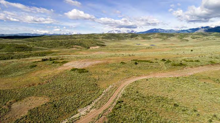
17 PROPERTY PHOTOS 7 Table of Contents


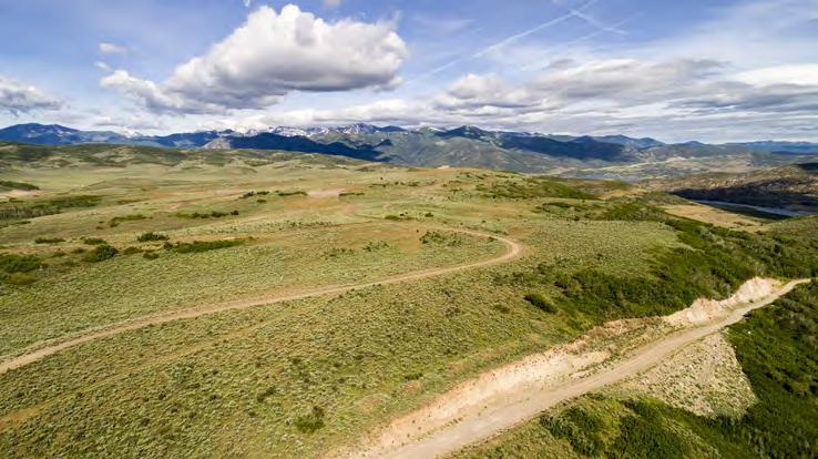
18 PROPERTY PHOTOS 8 Table of Contents
1/2 ACRE LOTS STARTING AT $85,000 - ALL INFO INCLUDED WASATCH COUNTY, UTAH
 1/2 ACRE LOTS STARTING AT $85,000 - ALL INFO INCLUDED WASATCH COUNTY, UTAH Zachary Hartman zhartman@landadvisors.com 6443 North Business Park Loop Road, Suite 12, Park City, Utah 84098 ph. 801.573.9181
±20 ACRES AVAILABLE IN HIDEOUT, UT
 ±20 ACRES AVAILABLE IN HIDEOUT, UT EXCLUSIVE LISTING ZONING: MOUNTAIN ZONE 1 ERU PER ACRE Zachary Hartman zhartman@landadvisors.com 6443 North Business Park Loop Road, Suite 12, Park, Utah 84098 ph. 801.573.9181
VALLEY RESORT PROPERTY
 Promontory DEER State VALLEY RESORT PROPERTY Canyon Trust Aspen Preserve Springs City ±37 ACRES AVAILABLE AT DEER VALLEY MOUNTAIN RESORT BALD MOUNTAIN The Colony EXCLUSIVE LISTING PARK CITY, UTAH North
DEER VALLEY RESORT PROPERTY
 DEER VALLEY RESORT PROPERTY ±37 ACRES AVAILABLE AT DEER VALLEY MOUNTAIN RESORT BALD MOUNTAIN EXCLUSIVE LISTING PARK CITY, UTAH SIZE ±37.098 acres PRICE Submit PARCELS 90-0000-3130, 90-0000-3132 USES/ZONING
HEBER EXCLUSIVE LISTING HEBER CITY, WASATCH COUNTY, UTAH
 HEBER 12.62 EXCLUSIVE LISTING HEBER CITY, WASATCH COUNTY, UTAH SIZE ±12.62 acres PRICE $1,200,000 PARCELS APN: OWC-1733-0-010-045 ALTAPN: 00-0009-3026 DRIVING DISTANCES SLC Int l Airport: 60 minutes Park
PARK CITY PRESERVE SOLD OUT!
 PARK CITY PRESERVE SOLD OUT! PARK CITY, UTAH WWW.PRESERVEPARKCITY.COM NEIGHBORHOOD INFOMATION Luxury Gated Community in Park City, Utah Elevation 6,400 to 7,900 looking at the Uinta Mountains Original
±10.23 ACRES MOUNTAIN VIEW CORRIDOR AB 71
 Bacchus Hwy ±10.23 ACRES MOUNTAIN VIEW CORRIDOR AB 71 Riverton Towne Center 12600 S EXCLUSIVE LISTING HERRIMAN, UTAH Hwy 13100 S 4000 W 13400 S 3600 W AB 85 AB 154 13800 S 2700 W Bluffdale 1300 W 13200
9 TO 71 ACRES INDUSTRIAL
 700 N ± G r e a t 9 TO 71 ACRES INDUSTRIAL S a l t L a k e LAND 80 EXCLUSIVE LISTING MAGNA, SALT LAE COUNTY, UTAH LOCATION W 4100S and S 8000 W, Magna, Salt Lake AB 202 County, Utah SIZE ± 9 to 71 PRICE
±10.23 ACRES MOUNTAIN VIEW CORRIDOR
 700 W 4000 W y Hw n a H e r rim Towne Center Riverton 1300 W 3600 W 12600UTH S EXCLUSIVE LISTING HERRIMN, 2700 W ±10.23 CRES MOUNTIN VIEW CORRIDOR 71 13200 S 13400 S 154 luffdale LOCTION The property is
46 PLAT READY LOTS IN MOUNTAIN GREEN
 46 PLAT READY LOTS IN MOUNTAIN GREEN EXCLUSIVE LISTING MORGAN, UTAH SIZE ±50.86 acres LOTS 46 lots PARCELS 00-0003-3330, 00-0005- 3056, 00-0075-2244 ZONING R1-20 DENSITY 0.97 Units/Acre COMMENTS Snowbasin
AB 172 AB 154 AB 68 AB 202 AB 201 AB 171 AB 111 AB 173 BEST NEW OPPORTUNITY IN MAGNA CITY MAGNA, SALT LAKE COUNTY, UTAH. Subject
 700 N MAGNA G r e a t ASCENT MPC S a l t L a k e 80 BEST NEW OPPORTUNITY IN MAGNA CITY MAGNA, SALT LAE COUNTY, UTAH AB 202 LOCATION W 4100S and S 8000 W, Magna, Salt Lake County, Utah SIZE ±71.75 acres
FOX HOLLOW MPC EXCLUSIVE LISTING SARATOGA SPRINGS, UTAH. LOCATION Redwood Road at Village Parkway in Saratoga Springs, Utah. PRICE Submit all Offers
 FOX HOLLOW MPC EXCLUSIVE LISTING SARATOGA SPRINGS, UTAH LOCATION Redwood Road at Village Parkway in Saratoga Springs, Utah PRICE Submit all Offers SIZE ± 360 ZONING R-10 and MF-10 UNIT COUNT Neighborhood
Berg Ridge BERG RIDGE 1
 Berg Ridge BERG RIDGE 1 Berg Ridge: $13,650,000 ($75,000 / ERU) Jordanelle Basin Wasatch County, Utah LOCATION: North Central Utah in the Jordanelle Basin of Wasatch County a 45-minute drive from downtown
EPPERSON INDUSTRIAL PARK
 EXCLUSIVE LISTING FUTURE INDUSTRIAL SITE ±680 ACRES SALT LAKE CITY, UTAH 3300 N Subject 40.54 acres 3200 W 550.46 acres 40.17 acres 2100 N 40.09 acres Sold Future State Prison Site ± 325 Acres Haul Road
CATARACT CREEK ESTATES
 CATARACT CREEK ESTATES EXCLUSIVE LISTING WILLIAMS, ARIZONA LOCATION NWC of Airport Road and Lake Ellen Way, Williams, Arizona SIZE ±38.95 acres LOT DESCRIPTION 55 P&E Single Family Lots (7,000 sq. ft.)
Woodland Mountain Property
 Woodland Mountain Property So Close, Yet So Far Away Summit County, Utah 5 Acres $79,000 3616 Elmwood Street, Salt Lake City, UT 84106 801-870-1801 info@landrancher.com Welcome to Woodland Mountain Enjoy
±20 ACRES AT THE ENTRANCE TO PRESCOTT LAKES
 ±20 ACRES AT THE ENTRANCE TO PRESCOTT LAKES EXCLUSIVE LISTING PRESCOTT, ARIZONA LOCATION The property is located at the NWC of Hwy 89 and Lakes Parkway,, AZ PRICE $1,195,000 ($1.36 per sq. ft.) SIZE ±20.11
Morgan Estates. Lassen County, CA. Proudly Offered By
 Morgan Estates Lassen County, CA Proudly Offered By 707 Merchant Street, Suite 100, Vacaville, Ca 95688 (707) 455-4444 Office (707) 455-0455 Fax info@caoutdoorproperties.com Introduction Looking North
BUCK POINT RANCH. Aspen Associates Realty
 BUCK POINT RANCH Aspen Associates Realty www.aspenassociatesrealty.com 970.544.5800 WELCOME TO Buck Point Ranch is a 960± acre property located in one of the last pristine valleys in close proximity to
HIGH COUNTRY L-BAR RANCH
 HIGH COUNTRY L-BAR RANCH Sandoval and mckinley counties N e w m e x i c o Jim Haworth, Ranch Team Lead Broker ~ 505-235-5236 3613 NMSR 528 NW, Ste. H, Albuquerque, NM 87114 505-792-3713 www.wwrealty.com
TAYLOR CANYON RANCH COLORADO - ROUTT COUNTY - STEAMBOAT SPRINGS
 TAYLOR CANYON RANCH COLORADO - ROUTT COUNTY - STEAMBOAT SPRINGS Tucked up against the steep valley shaped by Mt. Pau and rising to the Routt National Forest, Taylor Canyon Ranch is an easily accessible,
System Group Meeting #1. March 2014
 System Group Meeting #1 March 2014 Meeting #1 Outcomes 1. Understand Your Role 2. List of Revisions to Existing Conditions 3. Information Sources Study Area The Purpose of Mountain Accord is to Preserve
Brinker Creek Ranch. Colorado - Routt County - Yampa
 Located at the base of the Flattops Range in the Steamboat/Vail corridor, Brinker Creek Ranch consists of 1,451 acres ideally suited for high country grazing and native grass hay production. Traditionally
(Short Listing) DUPUYER ACREAGE, ROCKY MOUNTAN FRONT
 DUPUYER ACREAGE, ROCKY MOUNTAN FRONT") (Short Listing) DUPUYER ACREAGE, ROCKY MOUNTAN FRONT This unique property is located 8½ miles northwest of Dupuyer, Montana and approximately thirty 30 miles northwest of Choteau, Montana. Great Falls
(Short Listing) DUPUYER ACREAGE, ROCKY MOUNTAN FRONT This unique property is located 8½ miles northwest of Dupuyer, Montana and approximately thirty 30 miles northwest of Choteau, Montana. Great Falls
Lane Residence. Silverthorne, Colorado. Offered for $3,999,999. Contact Bill George. (970)
") Lane Residence Silverthorne, Colorado Offered for $3,999,999 Contact Bill George (970) 485 1052 bill@ranchland.com Ownership of this 6,450 square foot custom log home at Shadow Creek Ranch gets you access
Lane Residence Silverthorne, Colorado Offered for $3,999,999 Contact Bill George (970) 485 1052 bill@ranchland.com Ownership of this 6,450 square foot custom log home at Shadow Creek Ranch gets you access
1900 S 2800 W. 28 Spaces $499,000. Vernal, UT Outlaw Country RV Resort. For more information: Outlaw County RV Resort - Vernal, UT
 FOR SALE 28 Spaces Outlaw Country RV Resort 1900 S 2800 W Vernal, UT 84078 Property Features ACRES 19.38± 28 operable spaces Rent is $400 / Month Plenty of open space surrounding park for potential expansion
Indian Creek. Plumas County, California. Proudly Offered By
 Indian Creek Plumas County, California Proudly Offered By 707 Merchant Street, Suite 100, Vacaville, Ca 95688 (707) 455-4444 Office (707) 455-0455 Fax info@caoutdoorproperties.com Introduction House looking
BUTCHER CREEK RANCH. Butcher Creek Ranch. Roscoe, Montana. Reduced to $1,650,000.
 BUTCHER CREEK RANCH Butcher Creek Ranch Roscoe, Montana Reduced to $1,650,000. Offered Exclusively By: Sonny Todd Real Estate 301 West First Avenue, PO Box 788 Big Timber, Montana 59011 Office: (406) 932-1031
2018 Annual Report. Commercial Market
 218 Annual Report Commercial Market Introduction Our History... Your Future NAI Mountain Commercial was founded originally as Vail Commercial Advisors in April 26, to fulfill the unmet need of providing
Frizzell Creek Ranch Summerville, OR $1,400, ± Acres
 Frizzell Creek Ranch Summerville, OR $1,400,000 165± Acres 1 Introduction The Frizzell Creek Ranch is a beautiful 165± acre ranch located in northeast Oregon at the base of the Wallowa Whitman National
BROCHURE. APPLE HILL WOODS 118 +/- Acres Camino, California. Presented by Jim Copeland
 BROCHURE APPLE HILL WOODS 118 +/- Acres Camino, California Presented by Jim Copeland 1 The Property This 118 acre is a rare gem in the Sierra Nevada foothills. Covered with lush forestland and scattered
Exclusively offered by da Vinci Realty, LLC E. Aspen Ave., Flagstaff, AZ 86001
 Office Building 718 North Humphreys Flagstaff, Arizona 86001 FOR SALE $880,000 view from land facing Southeast www.davincirealty.com Exclusively offered by da Vinci Realty, LLC Darien Mark T. Belsanti,
Weston County, Wyoming
 The Sweet 200-Acre Property Weston County, Wyoming A unique opportunity to own a little piece of the old West, where one can experience unparalleled scenery, adventure and history walk in the footsteps
Washakie Wilderness Ranch
 Washakie Wilderness Ranch Dubois, Wyoming Fly Fishing Hunting Ranching Conservation Washakie Wilderness Ranch Dubois, Wyoming Introduction: A stunning 160-acre parcel located at the base of the Ramshorn
N/NWC 107 TH AVENUE & CAMELBACK ROAD
 N/NWC 107 TH AVENUE & CAMELBACK ROAD EXCLUSIVE LISTING PHOENIX, ARIZONA Glen Ha Bethany Home Rd Subject N e w R i v e r 99th Ave AB101 Camelback Ranch - Ballpark Corporate Center Camelback Rd R i v e r
ELKO JUNCTION. Meridian Pacific, Ltd. CINEMA 6. ElkoJunction.com. Leasing Brochure Mountain City Highway, Elko, Nevada 89801
 ELKO JUNCTION Leasing Brochure S H O P P I N G C E N T E R ElkoJunction.com CINEMA 6 2755 Mountain City Highway, Elko, Nevada 89801 AVAILABLE FOR LEASE QSR Pad (Fronting Mountain City Hwy) Available QSR
THE RESERVE III AT SUGAR MOUNTAIN, NORTH CAROLINA
 THE RESERVE III AT SUGAR MOUNTAIN, NORTH CAROLINA Information Memorandum AUGUST 2015 THE RESERVE III Contents I. THE PROPERTY... 3 OVERVIEW... 3 READY TO BUILD... 4 INEXPENSIVE CONSTRUCTION... 5 ADDITIONAL
 SURVEYOR'S CERTIFICATE RIVERFRONT MASTER PLANNED MIXED USE DISTRICT PHASE 3 SUBDIVISION PLAT I, SATTAR N. TABRIZ, DO HEREBY CERTIFY THAT I AM A PROFESSIONAL LAND SURVEYOR LICENSED TO PRACTICE IN THE STATE
General Overview: Acreage:
 General Overview: The Beaver Creek Ranch is located on Beaver Creek in Shell Wyoming, at the base of the western slope of the Big Horn Mountains, one of the west s most spectacular back drops. With an
ECONOMIC PROFILE. Tourism
 ECONOMIC PROFILE Tourism Park City & Summit County Utah Prepared by Park City Chamber of Commerce Convention & Visitors Bureau P.O. Box 1630 ~ Park City, UT 84060-1630 800.453.1360 ~ 435.649.6100 ~ fax
±17.79 ACRES OF INDUSTRIAL LAND
 Midway Rd Chuicha Rd Cox ±17.79 ACRES OF INDUSTRIAL LAND EXCLUSIVE LISTING CASA GRANDE, ARIZONA Mesquite Tree LOCATION S/SWC Thorton Road and Highway 84 in, Arizona Legends SIZE ±17.79 acres (±774,932
LAKE MOUNTAIN PRELIMINARY
 VICINITY MAP VICINITY MAP PREPARED FOR:. THE EXISTENCE AND LOCATION OF ANY UNDERGROUND UTILITY PIPES, CONDUITS OR STRUCTURES SHOWN ON THESE S WERE OBTAINED BY A SEARCH OF THE AVAILABLE RECORDS, TO THE
David Johnson. Tom, Attached please find the final scoping letter and figures for your review. David
 David Johnson From: Sent: To: Cc: Subject: Attachments: David Johnson Tuesday, April 12, 2011 4:33 PM Thomas Malecek Dave Dyer; Jason Marks (jmarks@segroup.com) VWC Scoping Letter
Stagecoach Ranch. Colorado - Fremont County - Texas Creek 1
 Stagecoach Ranch Selected for the classic western film Cat Ballou, the Stagecoach Ranch features lush meadows, rock outcroppings, foothills, and 1 1/2 miles of Texas Creek in a picturesue setting with
B HALL RANCH FISHTAIL, MONTANA
 Brochure Courtesy of: B HALL RANCH FISHTAIL, MONTANA w w w. m c c a s l i n l a n d. c o m Page 1 LOCATION The Hall Ranch is ideally located in the foothills of the Beartooth Mountains, approximately 5
1803 West Hwy 160 Monte Vista, CO (719) TTY (719)
 TTY (719)") USDA Forest Service Rio Grande National Forest http://www.fs.fed.us/r2/riogrande 1803 West Hwy 160 Monte Vista, CO 81144 (719)852-5941 TTY (719)852-6271 USDI Bureau of Land Management San Luis Valley Center
USDA Forest Service Rio Grande National Forest http://www.fs.fed.us/r2/riogrande 1803 West Hwy 160 Monte Vista, CO 81144 (719)852-5941 TTY (719)852-6271 USDI Bureau of Land Management San Luis Valley Center
ECONOMIC PROFILE PARK CITY & SUMMIT COUNTY, UTAH
 ECONOMIC PROFILE PARK CITY & SUMMIT COUNTY, UTAH Prepared by the Park City Chamber of Commerce & Visitors Bureau PO Box 1630, Park City, UT 84060 1.800.453.1360 Economic Profile Packet Sections 1. Introduction
THE HIGHPOINT East 7800 South. Sandy, Utah Fully Furnished & Move In Ready! Tenant Improvements Available to Suit
 THE HIGHPOINT 1220 East 7800 South Sandy, Utah 84047 Fully Furnished & Move In Ready! Tenant Improvements Available to Suit 1 Property Overview Fully Furnished Modern Office Building Move In Ready Total
50 Largest U.S. Metropolitan Areas
 America s Racially : Opportunities and Challenges 50 Largest U.S. Metropolitan Areas Community types in the 50 largest metropolitan areas 39,333,003 2% 14,533,32 1,983,337 9% 10% 47,40,87 49,199,197 30,180,578
Ortiz River Ranch Pagosa Springs, Colorado
 Ortiz River Ranch Pagosa Springs, Colorado This ranch provides an exceptional opportunity to own a property with frontage on the San Juan and Navajo Rivers, lush irrigated pastures, and beautiful rolling
Ponderosa Pines Ranch
 PONDEROSA PINES RANCH Ponderosa Pines Ranch Shepherd, Montana $3,285,000. Offered Exclusively By: Sonny Todd Real Estate 301 W First, PO Box 788 Big Timber, MT 59011 Office: (406) 932-6668 (406) 932-LAND
(Short Listing) SOUTH FORK LOG CABIN, UTICA, MONTANA
 SOUTH FORK LOG CABIN, UTICA, MONTANA") (Short Listing) SOUTH FORK LOG CABIN, UTICA, MONTANA The South Fork Log Cabin is in the heart of thousands of acres of public land of the Lewis & Clark National Forest Service. This Cabin offers unlimited
(Short Listing) SOUTH FORK LOG CABIN, UTICA, MONTANA The South Fork Log Cabin is in the heart of thousands of acres of public land of the Lewis & Clark National Forest Service. This Cabin offers unlimited
815 E Highway ± AC $995,000. Duck Creek Village, UT Duck Creek Village Inn. For more information: Property Features FOR SALE
 FOR SALE 1.18± AC Duck Creek Village Inn 815 E Highway 14 Duck Creek Village, UT 84762 Property Features Located on one of Southern Utah s Scenic byways. Minutes from Zion LOT SIZE - ACRES 1.18± AC National
TOOELE MULTI-TENANT INVESTMENT OFFERING
 TOOELE MULTI-TENANT INVESTMENT OFFERING 54 South Main Street Tooele, Utah Sky Hazlehurst +1 801 837 2020 sky.hazlehurst@colliers.com Brad Brown +1 801 309 0399 brad.brown@colliers.com Colliers International
TAYLOR 40 MERIDIAN ROAD & AMITY MERIDIAN, IDAHO
 TAYLOR 40 MERIDIAN ROAD & AMITY MERIDIAN, IDAHO Tyler Johnson tjohnson@landadvisors.com 3597 E Monarch Sky Ln, Suite F-240 Meridian, ID 83646 ph. 208.866.3579 www.landadvisors.com The information contained
Sunrise Ranch 6890 acres, Jeff Davis County, Texas On the Fort Davis Scenic Loop
 Sunrise Ranch 6890 acres, Jeff Davis County, Texas On the Fort Davis Scenic Loop 432-386-2821 Cell 432-426-2024 Office james@kinglandwater.com King Land & Water LLC P.O. Box 109, 600 State Street, Fort
G R E E N R I V E R - W Y O M I N G - S W E E T W A T E R C O U N T Y
 G R E E N R I V E R - W Y O M I N G - S W E E T W A T E R C O U N T Y Minor Ranch All information contained herein is taken from sources considered reliable, but is not guaranteed by either seller nor
Policy PL Date Issued February 10, 2014
 Subject RENEWABLE ENERGY ON CROWN LAND Compiled by Renewable Energy Program, Biodiversity Branch Replaces Policy Directives Waterpower Site Release Crown Land Onshore Windpower Development - Crown Land
GOODALE TRAIL PROPERTY
 GOODALE TRAIL PROPERTY EXCLUSIVE LISTING 7015 W GOODALE TRAIL LANE NORTH OF EAGLE, IDAHO ADDRESS 7015 W Goodale Sage Trail Lane Canyon PARCEL R5415100020 SIZE ±6.19 acres ZONING Residential/Agriculture
LANDMARK LOCATION REDEVELOPMENT OPPORTUNITY ±24.04 ACRES 9400 WEST 4TH STREET RENO, NV HISTORIC RIVER INN/ HOT SPRINGS RESORT FOR SALE
 FOR SALE ±24.04 ACRES RENO, NV LANDMARK LOCATION REDEVELOPMENT OPPORTUNITY INVESTMENT SUMMARY The River Inn and Mineral Spa is a landmark location in the Reno area. Originally known as Granite Springs
Ranch. Creek. Cow. Mountain
 Cow Creek Mountain Ranch Situated along the southwestern hills of the Laramie Mountains and the Medicine Bow-Routt National Forest in northeastern Albany County, Wyoming. 58 E. Benteen Street Buffalo,
The Airport (continued...)
") The Airport The Ogden-Hinckley Airport (OGD) is the primary reliever airport for the Salt Lake City International Airport. It is approximately three miles Southwest of Ogden. OGD received part of its name
The Airport The Ogden-Hinckley Airport (OGD) is the primary reliever airport for the Salt Lake City International Airport. It is approximately three miles Southwest of Ogden. OGD received part of its name
South Willow Creek Musselshell County Montana
 South Willow Creek Musselshell County Montana Clifton M. Berglee, D.V.M. (Listing Broker) 406-860-7319 cell cberglee@montwyowest.com Phone: (406) 628-2341 (office) Website: montwyowest.com P.O. Box 578,
LENDER OWNED ±6.8 ACRES IN GRIFFITH COMMERCE PARK EXCLUSIVE LISTING NEC 107TH AVENUE & VAN BUREN STREET, AVONDALE, ARIZONA
 Central Ave El Mirage Rd 107th Ave LENDER OWNED ±6.8 ACRES IN GRIFFITH COMMERCE PARK EXCLUSIVE LISTING NEC 107TH AVENUE & VAN BUREN STREET, AVONDALE, ARIZONA Litchfield Litchfield gwam Blvd Sunrise Palm
2321 Filbert Street OAKLAND. O f f e r i n g M e m o r a n d u m. EXCLUSIVE AGENT TOM SOUTHERN CA RE License #
 2321 Filbert Street OAKLAND O f f e r i n g M e m o r a n d u m EXCLUSIVE AGENT TOM SOUTHERN 510.923.9158 tsouthern@ngkf.com CA RE License #01808807 EXECUTIVE SUMMARY Newmark Knight Frank is pleased to
HIGHLINE. a GARDNER-STAKER V ENTURE
 HIGHLINE S t a t i o n a GARDNER-STAKER HIGHLINE STATION 65 East Highland Drive, Draper, Utah This mixed-use development located in the heart of Utah Silicon Slopes is poised to be a landmark in the Wasatch
Disclosure Document for Castle Mountain Resort Future Development
 Disclosure Document for Castle Mountain Resort Future Development September 2018 1._ Introduction Castle Mountain Resort Inc. (CMR) has completed a Master Development Plan that proposes to expand the existing
Treaty Oaks Ranch 323+/- Acres Hood County, Texas $1,776,500
 Bret Polk Mobile: (254) 965-0349 Office: (214) 361-9191 Treaty Oaks Ranch 323+/- Acres Hood County, Texas $1,776,500 LOCATION: The ranch is located in a desirable area 10+/- miles south of Granbury, Texas,
PAUL S PLACE ELK, DEER AND VIEWS FISHTAIL, MONTANA
 McCaslin Land 2010 PAUL S PLACE ELK, DEER AND VIEWS FISHTAIL, MONTANA LOCATION Paul s Place is ideally located in the foothills of the Beartooth Mountains, approximately 5 to 5-1/2 miles west of Fishtail,
find your true Real Estate Guide Winter
 find your true Real Estate Guide Winter 2017-2018 It s time to deepen your connection with Crested Butte. You already love it. Now is the time to live it. Dave Kozlowski The official real estate brokerage
Offering Memorandum. Established Retail Center with Upside High Traffic Intersection 565 Village Drive Pagosa Springs, CO
 Offering Memorandum Established Retail Center with Upside High Traffic Intersection 565 Village Drive Pagosa Springs, CO 81147 505.878.0001 Cole Flanagan, CPA cell 505 235 7585 cole@iparealty.com Clayton
HUGE NICOLA LAKE DEVELOPMENT ACREAGE MERRITT, BC
 HUGE NICOLA LAKE DEVELOPMENT ACREAGE www.landquest.com SAM HODSON Direct Line: (604) 694-7623 101-313 Sixth Street, New Westminster, BC V3L 3A7 Phone: (604) 664-7630 Fax: (604) 516-6504 Toll Free: 1-866-558-5263
Proposed Action. Payette National Forest Over-Snow Grooming in Valley, Adams and Idaho Counties. United States Department of Agriculture
 United States Department of Agriculture Forest Service January 2012 Proposed Action Payette National Forest Over-Snow Grooming in Valley, Adams and Idaho Counties Payette National Forest Valley, Adams
Roduner Ranch FOR SALE. 5,878± Acres Potential Development Land. Merced County, California. Offices Serving The Central Valley
 FOR SALE 5,878± Acres Potential Development Land Merced County, California Offices Serving The Central Valley F R E S N O V I S A L I A B A K E R S F I E L D 7480 N. Palm Ave, Ste 101 3447 S. Demaree Street
A CASE FOR COMPLETING THE JORDAN RIVER PARKWAY: A
 A CASE FOR COMPLETING THE JORDAN RIVER PARKWAY: A safe crossing at 9000 South and 850 West Proposed 9000 South Underpass Parkway Timeline Parkway, Trail, and Tourism Facts Blueprint Jordan River 1971 1973
566± acres total - WILL DIVIDE Volusia County, FL
 L IC E N S E D HUNTING P RESERVE ts Q u a i l ahi ul anb l e are av r info! fo CALL TODAY LAKEFRONT PROPERTY PERFECTION This ranch lies on a natural sand ridge in North Volusia County, Florida and has
PROJECT OVERVIEW WHAT IS THE GENERAL PLAN? WHY UPDATE THE PLAN? THE GENERAL PLAN WILL: WASATCH CANYONS GENERAL PLAN UPDATE
 WASATCH CANYONS GENERAL PLAN UPDATE PROJECT OVERVIEW WHAT IS THE GENERAL PLAN? The General Plan establishes goals and policies as a basis for land use and development regulations, transportation planning,
Hartsel Springs Ranch 4,637 Acres Park County, Colorado $4,780,000
 Hartsel Springs Ranch 4,637 Acres Park County, Colorado $4,780,000 Presented By: Farm, Ranch & Recreational Real Estate Hartsel Springs Ranch 4,637 Acres Park County, Colorado $4,780,000 Property Description
ANNECY EXCLUSIVE LISTING GILBERT, ARIZONA
 ANNECY EXCLUSIVE LISTING GILBERT, ARIZONA LOCATION Property is located S/SEC of ive and Williams Field Road in Gilbert, Arizona PRICE Submit LOTS 311 Finished Row Lots ZONING MF/L HOA Designated Builder
Location. Site Attributes. List Price: 660 Acres - Santa Fe, New Mexico. Al Lilly Qualifying Broker R.E. search Associates (505)
") THE OFFERING Suerte del Sur 660 Acres - Santa Fe, New Mexico Location The property is in Santa Fe County and is approximately 11 miles due west of Santa Fe s historic Plaza. Santa Fe is a unique southwestern
THE OFFERING Suerte del Sur 660 Acres - Santa Fe, New Mexico Location The property is in Santa Fe County and is approximately 11 miles due west of Santa Fe s historic Plaza. Santa Fe is a unique southwestern
PRIME GRAND MONTECITO 52 EXCLUSIVE LISTING GRAND MONTECITO PARKWAY & DEER SPRING WAY LAS VEGAS, NV
 PRIME GRAND MONTECITO 52 EXCLUSIVE LISTING GRAND MONTECITO PARKWAY & DEER SPRING WAY LAS VEGAS, NV 215 CENTENNIAL BOWL UNDER CONSTRUCTION SUBJECT PROPERTY This premier property is one of if not the best
BST Coalition Annual Report 2005
 BST Coalition Annual Report 2005 I. Introduction The Bonneville Shoreline Trail Coalition (Coalition) is an organization of entities, both citizen and governmental, representing the communities in Utah
SOUTH INTERCHANGE AREA
 Santaquin City General Plan 1 Location and Characteristics The South Interchange Area of Santaquin is located west of Interstate 15 and south of 500 South (Figure 1). It includes properties already annexed
WHITE MOUNTAIN LAKES ±1,275 ACRES
 C Jay WHITE MOUNTAIN LAES ±1,275 ACRES EXCLUSIVE LISTING NAVAJO COUNTY, ARIZONA Taylor y Gulch LOCATION 2060 Creek Road,, Arizona SIZE ±1,275.38 acres PRICE $1,700,000 ($1,333 per acre) TERMS Seller financing
Village of Taos Ski Valley 2015 Master Plan. Recreation Element
 Village of Taos Ski Valley 2015 Master Plan Taos Ski Valley is known across the world for skiing and winter sports, but the Village has more to offer than advanced skiing terrain and short lift lines.
HUNTING PROPERTIES Bearpaw Trail Hand constructed with reclaimed timbers from a historic Stagestop.
 $4,500,000 #139289 428.0 AC $2,500,000 #138964 113.5 AC $24,9500,000 #137591 9,000.0 AC 8855 Bearpaw Trail Includes a 3 acre lake and borders Routt National Forest. 8925 Bearpaw Trail Hand constructed
±4.90 COMMERCIAL ACRES FOR SALE
 ±4.90 COMMERCIAL ACRES FOR SALE EXCLUSIVE LISTING NWC PERRYVILLE ROAD & PEORIA AVENUE SURPRISE, ARIZONA Sun Valley Pkwy White Tank Mountain Regional Park Subject!( Olive Ave White Tank trus AB303 Gateway
SADDLE CREEK ENTRANCE (PRIVACY) GATE OPERATING AGREEMENT BETWEEN SADDLE CREEK COMMUNITY SERVICES DISTRICT AND CASTLE & COOKE CALIFORNIA, INC
 GATE OPERATING AGREEMENT BETWEEN SADDLE CREEK COMMUNITY SERVICES DISTRICT AND CASTLE & COOKE CALIFORNIA, INC") SADDLE CREEK ENTRANCE (PRIVACY) GATE OPERATING AGREEMENT BETWEEN SADDLE CREEK COMMUNITY SERVICES DISTRICT AND CASTLE & COOKE CALIFORNIA, INC This Saddle Creek Privacy Gate Operating Agreement ( Agreement
SADDLE CREEK ENTRANCE (PRIVACY) GATE OPERATING AGREEMENT BETWEEN SADDLE CREEK COMMUNITY SERVICES DISTRICT AND CASTLE & COOKE CALIFORNIA, INC This Saddle Creek Privacy Gate Operating Agreement ( Agreement
PAWLEYS ISLAND BUSINESS PARK
 PAWLEYS ISLAND BUSINESS PARK 0 Petigru Drive Pawleys Island, SC 29585 FOR SALE + / - 1 4. 4 5 a c r e s a v a i l a b l e M a s t e r Planned Industrial Flex Park For More Information, Contact: Alan Bolduc,
TOTEM APARTMENTS $2,300,000. Offering Memorandum , & st Ave S SeaTac, WA Investment Highlights
 $2,300,000 Offering Memorandum TOTEM APARTMENTS 16644, 16648 & 16652 31st Ave S SeaTac, WA 98188 Investment Highlights Meticulously Maintained Property Well Located Close to Light Rail Station Large Units
Eagle Pinon Ranch. 2,963 +/- acres, Hudspeth County
 Eagle Pinon Ranch 2,963 +/- acres, Hudspeth County Eagle Piñon Ranch 2963 acres Hudspeth County, Texas Location The Eagles are part of a chain of sky island mountains that stretch from New Mexico through
Meadow Creek and Goat Creek pass through Goat Falls Ranch & Alpine Peak
 Henri W. LeMoyne 1346 Fillmore Street Post Office Box 5225 Phone: (208) 733-0874 Fax: (208) 733-8475 E-mail: henri@lemoynerealty.com Twin Falls, Idaho 83303-5225 Location: The Goat Falls Ranch is located
This section of the Plan provides a general overview of the Smoky Mountain Region. It consists of the following four subsections:
 SECTION 3 COMMUNITY PROFILE This section of the Plan provides a general overview of the Smoky Mountain Region. It consists of the following four subsections: 3.1 Geography and the Environment 3.2 Population
Arrowhead Ranch. Located in the Big Range Country of Central Wyoming.
 Arrowhead Ranch Located in the Big Range Country of Central Wyoming. 58 E. Benteen Street Buffalo, WY 82834 Ph 307-684-9556 Toll Free 888-684-9557 Fax 307-684-8565 Location The ranch is approximately:
The Absaroka Mountain Lodge
 The Absaroka Mountain Lodge Park County, WY I believe our setting is the most beautiful of any of the lodges up the Northfork Current owner 58 E. Benteen Street Buffalo, WY 82834 Ph 307-684-9556 Toll Free
The View at Bankhead Lake 12 miles off new Interstate Corridor X
 The View at Bankhead Lake 12 miles off new Interstate Corridor X offers the opportunity to the first to view 6 beautiful waterfront lots on Bankhead Lake to be released Saturday August 25th. Appointment
LENDER OWNED ±6.8 ACRES IN GRIFFITH COMMERCE PARK
 Central Ave El Mirage Rd 107th Ave LENDER OWNED ±6.8 ACRES IN GRIFFITH COMMERCE PARK EXCLUSIVE LISTING NEC OF 107TH AVENUE AND VAN BUREN STREET, AVONDALE, ARIZONA un Health Litchfield wam Blvd Sunrise
PRESCOTT HIGHLANDS ESTATES
 PRESCOTT HIGHLANDS ESTATES EXCLUSIVE LISTING PRESCOTT, ARIZONA Lot 33 LOCATION Property is located north and south of Delano Avenue on Barrett Drive and Coulter Bay Court in, Arizona SIZE 13 Finished Lots
April 10, Mark Stiles San Juan Public Lands Center Manager 15 Burnett Court Durango, CO Dear Mark,
 Mark Stiles San Juan Public Lands Center Manager 15 Burnett Court Durango, CO 81301 Dear Mark, We are pleased to offer the following comments on the draft San Juan Public Lands Center management plans
Flying W Guest Ranch. Oklahoma - Beckham County - Elk City
 Flying W Guest Ranch Oklahoma - Beckham County - Elk City 2 Flying W Guest Ranch is a well-known guest ranch in a historic location about 90 miles west of Oklahoma City near Elk City, Oklahoma. Situated