Q u i e t l y P a v i n g P a r a d i s e
|
|
|
- Erika Welch
- 5 years ago
- Views:
Transcription


1 Q u i e t l y P a v i n g P a r a d i s e H o w B u s h p o l i c i e s s t i l l t h r e a t e n A m e r i c a s n a t i o n a l f o r e s t s

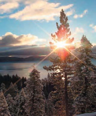
2 Authored by: Nicole Gentile Environment America Research & Policy Center 218 D Street SE Washington, D.C About The Photographs: Over the past four years Dr. Nelson Guda has traveled tens of thousands of miles, hiking and kayaking into some of the least known National Forest lands in the US to photograph our country s Inventoried Roadless Areas. The photographs in this report are from his upcoming book his search for these places. In February, 2009, photographs from Dr. Guda s roadless project were exhibited in the rotunda of the Russell Senate Building in Washington, DC. As part of his effort to bring more public awareness to the issue of roadless area conservation, Dr. Guda also created Roadlessland.org, a website that maps and displays photographs and information about all of the lands covered by the Roadless Rule. Contents Executive Summary... 4 Background... 5 Oregon s Forests... 6 Alaska s Forests... 8 Idaho s Forests Colorado s Forests Conclusion Methodology Endnotes Credits For more information about Dr. Nelson Guda s book see: For maps and detailed information about individual roadless areas see: Cover: Tongass National Forest, Alaska This Page: Pioneer Mountains, Idaho Q u i e t l y P a v i n g P a r a d i s e


3 Executive Summary Background America s roadless national forests are treasured pieces of our common landscape and heritage. Pristine forests have provided generation after generation of Americans with clean air and water, and opportunities to experience the beauty of the great outdoors. Furthermore, these forests represent some of the last suitable habitat for many species of wildlife. In 2001, the Roadless Area Conservation Rule offered protections for 58.5 million acres of our intact national forests against the threat of road building associated with logging, mining, and drilling. Unfortunately, the past eight years of forest policy rollbacks and legal battles have left these forests frighteningly vulnerable. Upon taking office, the Bush administration immediately halted implementation of the Roadless Rule, and attempted to replace it with a state petition process that undermined strong protections. As it now stands, forests from the Rockies to the Appalachians have questionable protections under the Roadless Rule. Due to pending court appeals and eight years of attempts to rollback forest policy, the future of the rule and the pristine forests it aims to protect is dangerously uncertain. In fact, our research found that national forests in Oregon, Alaska, Colorado, and Idaho are just some of the treasured landscapes facing more pressing threats than they have since the inception of the Roadless Rule. We looked at government documents detailing proposed logging, mining and road building projects and found that the bulldozers and chainsaws could start roaring into these forests as soon as this spring. At stake in Oregon are roadless areas in the Umpqua National Forest. A proposed timber sale threatens to destroy roadless forests including part of the Oregon Cascades Recreation Area. This project would bulldoze 1,515 acres and undermine the Roadless Rule that still stands in Western states. Alaska s Tongass National Forest is endangered by several pending projects that will devastate the lush, forested islands for which it is known. Projects such as the Logjam Timber Sale, Central Kupreanof Timber Harvest, Tonka Timber Sale, Kuiu Timber Sale and Iyouktug Timber Sale threaten to permanently mar tens of thousands of acres. Under a state specific Roadless Rule created during the Bush administration, Idaho s forests have weaker protections than other forests across the country. A full 405,900 acres have been placed into a management category that allows road construction and emphasizes access for phosphate mining. J.R. Simplot, a company that mines phosphate all across Idaho, is pushing leases forward. Additionally, five million acres of roadless forests across the state have weakened protections to accommodate logging. On the heels of the Idaho rule, the state of Colorado is on its way to finalizing its own state specific Roadless Rule. This rulemaking has reduced protections in roadless forests that are of interest to coal and oil and gas companies. Currently included in the proposed rule are exemptions for future coal mining at Priest Mountain and oil and gas leases in the Clear Fork Divide Roadless Area. Q u i e t l y P a v i n g P a r a d i s e Mallard Larkins, Idaho Despite the number of acres of national forests that are threatened by pending projects, there is still hope. President Obama has made clear his support for strong protections of our roadless national forests. The time has come for immediate action to ensure these forests are around for future generations. Department of Agriculture Secretary Vilsack has the power to issue a time out for our forests. Secretary Vilsack should require secretarial-level approval of any U.S. Forest Service project that might be inconsistent with the rule to protect these wild forests while steps are taken to fully implement the Roadless Area Conservation Rule. Time is running out for these wild lands. The administration has to act quickly to preserve our roadless forests for future generations. After all, once they re gone, they re gone forever. North Fork of Clearwater, Idaho From the dramatic coastlines of Alaska s temperate rainforest to the lush, deciduous, eastern forests of the Appalachians, America s national forests are invaluable pieces of our natural heritage. Already more than half of our national forests are crisscrossed with roads and development. The remaining 58.5 million acres of untouched, roadless national forests have varying degrees of protection. This was not always the case. In January of 2001, President Clinton signed a rule to protect all 58.5 million acres of our last roadless forests from road construction associated with logging, mining, and drilling. The Roadless Area Conservation Rule was the result of the most popular and extensive rulemaking process in history, receiving more than 1.6 million public comments over 95 percent of which supported strong protections for these forests. 1 In addition to providing drinking water for 60 million Americans 2 and offering unmatched opportunities for outdoor recreation, America s national forests are invaluable sanctuaries for wildlife. Roads and development greatly reduce the quality of this habitat. Roads lead to increased erosion, air and water pollution, spread of invasive exotics, wildlife mortality, and habitat fragmentation. 3 All of these factors degrade the already sparse suitable habitat for wildlife and fragment them into smaller and more isolated islands in a sea of development. Despite the recreational and ecological significance of our roadless forests, the Bush administration halted implementation of the Roadless Rule upon taking office, refused to defend it against legal challenges, and attempted to replace it with a state petition process. The administration also temporarily exempted 8.5 million acres of national forest lands in Alaska from Roadless Rule protections. The status of the rule is uncertain due to legal conflicts between courts in California and Wyoming. Appeals are pending in both circuits. Our research uncovered that under the nose of a new, environmental administration, there are several projects pending that could devastate some of America s most treasured roadless forests in Oregon, Alaska, Idaho and Colorado. If immediate action is not taken, these pristine forests could be lost forever. The following pages highlight some of the most egregious threats to the roadless forests that the Roadless Rule was meant to protect. Q u i e t l y P a v i n g P a r a d i s e


4 Oregon s Forests Oregon s national forests boast some of the most spectacular scenery in the country. From the towering peaks of Mount Hood to the rivers and streams of the Umpqua National Forest, it is no wonder that people travel from across the country and the world to experience Oregon s great outdoors. Beyond their scenic value, Oregon s national forests have tremendous ecological significance. Lush stands of cedar, hemlock, and Douglas-fir cloak the mountain tops, transitioning to mixed conifers and hardwoods in the lower elevation forests. Hundreds of species of wildlife, including 58 that are listed as endangered or threatened, make their home in Oregon s forests. 4 Forests at Risk Named for its thundering waters, the Umpqua National Forest provides an outstanding backdrop for recreational opportunities. The waterways and diverse landscapes of the forest create a unique habitat that supports more than 250 species of wildlife. 5 Right in the heart of the Umpqua, the innocuous-sounding D-Bug Hazard Reduction Timber Sale Project threatens to encroach upon this beautiful landscape. The D-Bug timber sale will allow commercial logging on some of Oregon s last intact forests. The specific forests at risk include Mt. Bailey and Thirsty Creek Appendage Inventoried Roadless Areas and the roadless Oregon Cascades Recreation Area. Logging would take place on 1,515 acres of roadless forests, scarring some of Oregon s most cherished landscape. 6 Eagle Creek, Oregon Oregon contains more than 15 million acres of national forest land, but currently only 1.97 million of these acres are roadless areas. With a thriving outdoor community from hikers and campers to hunters and anglers, it may come as a surprise that many of Oregon s pristine forests are facing serious threats. Mt Hood National Forest, Oregon The Forest Service is using the threat of mountain pine beetles in the Diamond Lake Ranger District as grounds for logging and thinning in roadless forests, even though there is disagreement as to the effectiveness of this approach. Mountain pine beetles predominantly affect lodgepole pine stands, but can be found in other pine species as well. While the Forest Service justifies logging in these forests to contain the beetles, a recent scientific study that modeled beetle outbreak shows the opposite. The authors found a higher rate of tree mortality from beetle infestation in thinned forests versus forests that were left untouched. The findings even suggested an increased rate of wild fire in these thinned forests. 7 Furthermore, roads and other disturbances exacerbate the spread of pathogens such as invasive species. Logging and road building projects stress ecosystems by removing vegetation and allowing easier movement through the ecosystem by invasive species. These factors can increase chances of outbreak. 8 Clearly, there is no strong scientific case that logging in roadless forests will address a beetle epidemic. Instead, untouched forests have proven to be resilient when left to their natural processes. In addition to being based on questionable science, the D-Bug project could set a precedent for road building in pristine forests in Oregon and across the country. For eight years, despite legal and administrative challenges, the Roadless Rule has remained the law for protecting Oregon s almost 2 million acres of roadless national forests. If this project goes forward, it will be in violation of the Roadless Rule. Left unchallenged, the D-Bug project has the potential to increase the chances of future development in all of America s roadless forests. Logging would take place on 1,515 acres of roadless forests, scarring some of Oregon s most cherished landscape. 6 Q u i e t l y P a v i n g P a r a d i s e Q u i e t l y P a v i n g P a r a d i s e


5 Forest Service officials have continued to push timber sales in roadless areas across the state. Alaska s Forests Towering old growth stands, the northern lights, wild, forested islands the Tongass is the largest temperate rainforest in the world and the nation s largest national forest. Covering most of Southeast Alaska, the Tongass provides unmatched opportunities to experience the breath-taking landscapes of wild America. The lush vegetation of the Tongass National Forest, including bountiful forests of Sitka spruce, western hemlock, shore pine and yellow cedar, provide invaluable habitat for hundreds of species of wildlife. Southeast Alaska is home to more than 300 species of birds such as the forest-dwelling goshawk and marbled murrelet. 9 The cool, clear, streams and waterways in the Tongass National Forest provide exceptional, pristine habitat for spawning salmon and trout. These water resources support Alaska s popular and economically valuable sport and commercial fishing industries. In 2001, the Roadless Rule included this majestic temperate rainforest s 8.5 million acres of roadless areas under its protections. 10 However, in 2005 the Bush administration temporarily exempted the Tongass from the rule, leaving its roadless forests vulnerable to destruction. This possibility came closer to reality when the U.S. Forest Service released the 2008 Forest Management Plan for the Tongass, allowing logging on thousands of acres of roadless forest. Since then, Forest Service officials have continued to push timber sales in roadless areas across the state. Highlighted below are just a few of the proposed projects scheduled to start as soon as this spring. Other sales are in the planning stages. On Prince of Wales Island, the Logjam Timber Sale is progressing quickly through the decision process. This project would allow logging on 99 acres of roadless forests in Prince of Wales Island, leaving this wild forest with logging roads and tree stumps in place of pristine habitat. 14 The draft plan for the project was released in December of 2008, and this forest could be opened to logging in the coming year. Prince of Wales neighbor to the North is Kupreanof Island. The draft plan for the Central Kupreanof Timber Sale proposes logging 70.2 million board feet, which means hundreds of thousands of trees, in the heart of this island. Included in the affected area are 1,220 acres of roadless forests, 434 acres of which will be logged. 15 This would leave the lush forests of this island marred by timber roads and clear-cuts. Also under threat on Kupreanof Island is the Lindenberg Peninsula, where the planning process for the Tonka Timber Sale began in January of The proposed project area would include 30,689 acres of roadless areas, meaning that about half of the project would take place within roadless forests. 16 The entire 22,445 acres of the Lindenberg Roadless Area and a vast 8,244 acre section of the Green Rocks Roadless Area would be logged. The Forest Service estimates a need for 11 miles of new roads, some of which would be in roadless areas. Logging could begin as early as next year and would devastate an entire section of the island. When looking at the projects outlined here, more than 54,000 acres of roadless forest will be affected. This acreage includes the Kuiu, Iyouktug, Logjam, Kupreanof, and Tonka timber sales. Forests at Risk Alaska s Tongass National Forest spans the length of the Alexander Archipelago. These islands are covered with towering forested mountains that are mirrored from below by deep valleys, streams, and saltwater bays carved by receding glaciers. Sitka black tailed deer, bear and wolves roam these islands, and it is not uncommon to see bald eagles soaring above the treetops. The bountiful waterways are brimming with several species of salmon, halibut and red snapper. 11 Tongass National Forest, Alaska Tongass National Forest, Alaska The pristine islands of the Tongass have two logging projects that are approved to go forward. One of these projects is the Kuiu Timber Sale on North Kuiu Island. The final decision states that 397 acres will be affected by this project, including logging and road building on 114 acres in the North Kuiu and Security Creek Roadless Areas. 12 Further north, another urgently threatened forest lies in the northeastern section of Chichagof Island. The final Iyouktug Timber Sale documents were published in April of There are 22,249 acres of roadless forest included in the project area, and 1,871 of these acres would be logged. 13 Currently these lands are up for sale to the highest bidder. Q u i e t l y P a v i n g P a r a d i s e 9


6 Idaho s Forests Snow-capped mountains, wildflower-filled grasslands, babbling brooks, verdant stands of conifers Idaho is so much more than a state of potatoes and agriculture. The Gem State contains 20.5 million acres of national forest land, 9.3 million of which are designated roadless. The Caribou-Targhee National Forest, which dominates the northern part of the state, is a part of the Greater Yellowstone Ecosystem. At a massive 12 million acres, this ecosystem is the largest remaining block of pristine plant and animal habitat in the contiguous United States. The forest has gained international recognition for its ecological significance, and the United Nations has designated the area a Biosphere Reserve. Residing in the heart of this untouched wilderness are diverse wildlife species such as grizzly bear, lynx, cutthroat trout, wolverines, elk, and mule deer. Forests at Risk In response to the Bush administration s attempt to implement a state by state petition process, Idaho s then-governor, Jim Risch, submitted a petition for the management of Idaho s roadless national forests. The state by state petition process was thrown out by a court ruling in 2006, but the Bush administration chose to keep reviewing petitions through an existing policy, the Administrative Procedure Act (APA). The result has been the implementation of a state-specific Roadless Rule for Idaho. Thanks to the hard work of environmental, tribal, hunting and angling, and community groups in Idaho, the final rule has much stronger protections for roadless forests than the initial proposal. However, there are still large parcels of pristine forests that are carved out to benefit special interests. The Idaho Roadless Rule employs five management themes that regulate the management of roadless forests in Idaho. About 405,900 acres would be designated as General Forest, Rangeland, and Grassland under the Idaho Roadless Rule. This management theme allows road construction for phosphate mining and logging in roadless areas. 17 has been actively mining this phosphate from Idaho s roadless forests for years because its current mining operations were allowed under a grandfather clause in the Roadless Rule. However, the Simplot Company submitted a proposal to extend its open pit phosphate mining operations in the Smoky Canyon Mine further into roadless areas. This would allow clear-cutting and open pit mining in the Sage Creek and Meade Peak Roadless Areas. The Idaho Roadless Rule clears the way for this mine development. Under the Idaho rule, the two areas in question Sage Creek and Meade Peak are placed under the General Forest, Rangeland, and Grassland management theme, thereby allowing logging, mining and drilling. However, these two roadless areas are not the only forests that are vulnerable. In fact, a huge swath of southeastern Idaho will be opened to highly toxic phosphate mining. Also included in the General Forest, Rangeland, and Grassland management theme are Dry Ridge, Stump Creek, and Huckleberry Basin Roadless Areas in southeastern Idaho. 18 There are an estimated 260 million tons of phosphate deposits that will be mined from 5,770 unleased acres across the state, impacting a total of 6,580 roadless acres. 19 Beyond opening nearly half a million acres to immediate development, the Idaho Roadless Rule, to accommodate temporary roads for logging, weakens protections for more than 5 million additional acres designated as Backcountry. Under this plan, Idaho s roadless forests would see 15,000 acres logged over the next 15 years. Furthermore, roads could be built on 253,500 acres of roadless areas with highly sensitive soils and will be conditionally allowed on an additional 1,786,400 acres of roadless forests. 20 Phosphate mining, logging and associated road building threaten a huge portion of roadless land that was protected under the Roadless Area Conservation Rule. Under Idaho s state specific rule, these projects could go forward at any point. Phosphate mining, logging and associated road building threaten a huge portion of roadless land that was protected under the Roadless Area Conservation Rule. In particular, J.R. Simplot, a large agribusiness based in Boise, Idaho, stands to substantially benefit if these areas are no longer protected. One of their main products is chemical fertilizer, of which phosphate is a major component. J.R. Simplot 10 Q u i e t l y P a v i n g P a r a d i s e A J.R. Simplot phosphate mine in the Caribou-Targhee National Forest Pallisades Mountains, Idaho

7 Colorado s Forests Hillsides of aspen and ponderosa pine stretching below jagged mountain peaks covered with spruce Colorado s mountains could be described as an arboreal mosaic. Colorado s national forests are arguably some of the most popular outdoor recreation destinations in the country attracting millions of visitors each year and driving Colorado s $10 billion a year outdoor recreation industry. 21 The towering Rocky Mountains and their rolling foothills support hundreds of wildlife species including mountain lions, elk and big horn sheep. Also found in Colorado s forests are 31 species of threatened or endangered wildlife. 22 term temporary roads and coal mining and exploration would be allowed in about 29,000 acres of the area. 26 The draft rule specifically states that the North Fork area is open to future development. This opens the door to future leasing and new habitat-fragmenting roads in some of Colorado s last intact forests. The same danger applies in the region known as the Clear Fork Divide. It is an ecologically rich area that straddles the White River National Forest and the Gunnison National Forest, northwest of Aspen, and the renowned Maroon Bells Wilderness Area. This complex of nearly 100,000 acres of roadless forests is heralded for its backcountry hunting opportunities and it is an important calving area for elk. 27 A wide range of vegetation can be found, including sprucefir, aspen, pinion-juniper, and sagebrush. Thompson Creek, one of seven roadless areas making up the complex, provides intact habitat for bear and the endangered Canada lynx. 28 The Colorado River cutthroat trout can also be found through the roadless complex. Unfortunately, this region is one of the most threatened under the proposed U.S. Forest Service rule for Colorado. The Wilderness Society reported in August 2006 that 20,000 acres of roadless areas had been leased to oil and gas companies, including the Clear Fork Roadless Area. 29 The Pew Environment Group identified forty-five of these so called gap leases in the Clear Fork Divide that could allow for road building under a loophole created by the wrangling in the courts. However, the proposed rule does not address these threats. 30 Forests at Risk Following on the heels of the Idaho Roadless Rule, the U.S. Forest Service is creating a state specific Roadless Rule for Colorado. The draft rule fails to measure up to the Roadless Area Conservation Rule level protections, allowing for more logging, drilling and mining in some of Colorado s last intact forests. The potential negative impacts of the Colorado Rule on forest ecosystems could include long term temporary roads which could be in place for 30 years before being decommissioned. The effects of soil compaction and the spread of invasive species would begin immediately. According to Forest Service planning documents, the proposed rule would significantly increase the spread of invasive plants at a rate of 38 acres per year versus the current 4 acres per year. Logging in roadless areas would increase by 102,000 acres over the next fifteen years. Projections for oil and gas development would increase by 422 wells, providing much more opportunity for oil and natural gas development and productions than the 2001 rule according to the Forest Service. 23 The draft rule would greatly reduce the wild and natural character of Colorado s forests and leave them with significantly weaker protections than the national Roadless Rule. Below are two examples of areas at risk. One of the most glaring problems with the Colorado Roadless Rule can be found in five roadless areas surrounding Priest Mountain. Located east of Grand Junction, much of the Priest Mountain area offers opportunities for camping, hiking, and challenging terrain for outdoor enthusiasts to explore, such as steep oak brush canyons. 24 The Colorado Division of Wildlife identified this area as an important calving ground for deer and elk and noted that black bears visit the area for its abundant acorns and choke cherries. 25 The Priest Mountain area is also the headwaters for the town of Hotchkiss, the Redland Mesa water system and Fruit Growers Reservoir. Priest Mountain is also part of what s known as the North Fork coal mining area in the Grand Mesa, Uncompahgre, and Gunnison National Forests. Under the proposed rule, long- Bear Mountain from Ice Lake Basin, Colorado This opens the door to future leasing and new habitat-fragmenting roads in some of Colorado s last intact forests. 12 Q u i e t l y P a v i n g P a r a d i s e Q u i e t l y P a v i n g P a r a d i s e 13

8 Conclusion Stunning beauty, pristine habitat, clean water, countless opportunities for hunting, fishing and recreating America s national forests are an invaluable resource and they should be treated as such. Decades of development have put undue stress on our forests, and what little we have left is vanishing quickly. Roadless forests represent some of the last strongholds of the great American wilderness, and these precious sanctuaries must be protected. Unfortunately, eight years of bad policy and legal wrangling have left our forests vulnerable to the threat of special interests. The bulldozers and chainsaws are ready at the edge of forests across the country, including Oregon, Colorado, Alaska and Idaho. Unless the administration takes immediate action, roads built for logging, mining, and drilling will crisscross these landscapes. With an environmentally friendly administration in place, this is the time to protect our forests for future generations. Secretary Vilsack, Obama s pick to oversee the Forest Service, has the power to stop all of these projects. He must implement a time out on all projects in roadless forests, including Alaska s Tongass National Forest, to ensure that policies of the past eight years don t result in clear-cutting projects on the new administration s watch. Secretary Vilsack should issue a directive that requires Secretarial-level approval of any U.S. Forest Service projects in roadless forests. A similar directive was set by U.S. Forest Service Chief Dale Bosworth in A time out would be in-line with President Obama s support for the Roadless Rule as a U.S. Senator and during his campaign for the presidency. Furthermore, a time out is necessary to ensure that these public lands including those outlined in this report will not be threatened while the federal courts conflicts are resolved and more permanent protections can be implemented. By implementing a time out, Secretary Vilsack will have the time to unravel the mess that the administration inherited and take necessary steps to fully reinstate the Roadless Rule. After all, with roadless forests you don t get a second chance once they are gone, they are gone forever. Methodology We looked at government documents detailing proposed logging, mining and road building projects in roadless forests. We used the Forest Service website s listings of Environmental Impact Statements and other planning documents to determine the timeline and scope of each project. This analysis includes projections for acres affected and miles of roads built in roadless national forests when these projects are completed. Endnotes 1 Heritage Forests Campaign, Our Roadless Areas, downloaded from: 2 April United States Department of Agriculture (USDA) Forest Service, Water & the Forest Service, FS-660, January Stephen C. Trombulak and Christopher A. Frissell, Review of Ecological Effects of Roads on Terrestrial and Aquatic Communities, Conservation Biology 14: 18-26, US Fish and Wildlife Service, Threatened and Endangered Species System, downloaded from: ecos.fws.gov/tess_public/statelisting. do?state=all, 28 March USDA Forest Service, Umpqua National Forest, downloaded from: 16 March USDA Forest Service, D-Bug Hazard Reduction Timber Sale Project Draft Environmental Impact Statement, 6 March A.A. Ager, A. McMahan, J.L. Hayes, and E.L. Smith, Modeling the Effects of Thinning on Bark Beetle Impacts and Wildfire Potential in the Blue Mountains of Eastern Oregon, Landscape and Urban Planning. 80: , See note 3. 9 USDA Forest Service, Birds in the Tongass, downloaded from: shtml, 16 March United States General Accounting Office, Forest Service Roadless Areas, November Prince of Wales Chamber of Commerce, downloaded from: 16 March USDA Forest Service, Kuiu Timber Sale Record of Decision, 13 May USDA Forest Service, Iyouktug Final Environmental Impact Statement, 30 April USDA Forest Service, Logjam Timber Sale Draft Environmental Impact Statement, 12 December USDA Forest Service, Central Kupreanof Timber Harvest DEIS Summary, 8 December Christopher Savage, USDA Forest Service, Tonka Timber Sale Project 2009 Scoping Letter, January USDA Forest Service, Roadless Area Conservation; National Forest System Lands in Idaho Final Environmental Impact Statement, August USDA Forest Service, Idaho Roadless Rule Modified Management Themes, Map Packet Idaho Roadless Areas, August See note Ibid. 21 Outdoor Industries Association, Active Outdoor Recreation Creates Economic Growth, downloaded from: ColoradoRecEconomy.pdf, 30 March See note USDA Forest Service, Special Areas; Roadless Area Conservation; Applicability to the National Forests in Colorado; Proposed Rule, 25 July USDA Forest Service, Roadless Inventory and Evaluation of Potential Wilderness Areas, Available at 25 Colorado Division of Wildlife, General Comments on Inventoried Roadless Areas in GMUG, 21 February See note See note Ibid. 29 The Wilderness Society, Too Wild to Drill, downloaded from: wilderness.org/files/twtd-co-clear-fork.pdf, 30 March Pew Environment Group, Leasing Colorado s Legacy, downloaded from: 30 March Credits The author would like to thank Christina Goldfuss for her work and guidance on this project. Thanks also to Mike Anderson of The Wilderness Society, Rob Klavins of Oregon Wild, Matthew Garrington of Environment Colorado, Pete Kolbenschlag of Mountain West Strategies, Rocky Smith of Colorado Wild, Steve Smith of the Wilderness Society, Mark Schofield of Western Colorado Congress, Rob Peters of Western Slope Environmental Resource Council, Lisa Moreno and Peter Hart of Wilderness Workshop, Connor Bailey of Center for Native Ecosystems, Mat Jacobson of the Pew Environment Group, and Rob Vandermark of the Pew Environment Group. This report is made possible with funding from The Pew Charitable Trusts. The opinions expressed in this report are those of the authors and do not necessarily reflect the views of our funders. Absoroka Mountians, Wyoming Report designed by Frank Hamilton Cover photo Nelson Guda 14 Q u i e t l y P a v i n g P a r a d i s e Q u i e t l y P a v i n g P a r a d i s e 15


9 218 D Street SE, 2nd Floor Washington, D.C
Roadless Forest Protection
 Roadless Forest Protection On January 12, 2001, after nearly three years of analysis and the greatest public outreach in the history of federal rulemaking, the U.S. Forest Service adopted the Roadless
$850,000 Awarded to 20 Organizations
 $850,000 Awarded to 20 Organizations The Conservation Alliance is pleased to fund the following organizations to support their efforts to protect wild lands and waterways for their habitat and recreation
Saving Our Natural Legacy
 Saving Our Natural Legacy The Future of America s Last Roadless Forests A CENTER FOR BIOLOGICAL DIVERSITY REPORT Saving Our Natural Legacy: The Future of America s Last Roadless Forests By Marc Fink, Chris
April 10, Mark Stiles San Juan Public Lands Center Manager 15 Burnett Court Durango, CO Dear Mark,
 Mark Stiles San Juan Public Lands Center Manager 15 Burnett Court Durango, CO 81301 Dear Mark, We are pleased to offer the following comments on the draft San Juan Public Lands Center management plans
Washakie Wilderness Ranch
 Washakie Wilderness Ranch Dubois, Wyoming Fly Fishing Hunting Ranching Conservation Washakie Wilderness Ranch Dubois, Wyoming Introduction: A stunning 160-acre parcel located at the base of the Ramshorn
USDA Trails Strategy WRI: ENGLISH PEAK SURVEY. Theodore Mendoza San Diego State University June 6 th 2016 August 18 th Advisor: Sam Commarto
 WRI: ENGLISH PEAK SURVEY Theodore Mendoza San Diego State University June 6 th 2016 August 18 th 2016 Advisor: Sam Commarto Klamath National Forest Submitted: March 21, 2017 Table of Contents Acknowledgements
Outreach Notice. FREMONT-WINEMA NATIONAL FOREST Zone Planning Staff GS Winter Rim Zone Paisley and Silver Lake Ranger Districts
 Outreach Notice FREMONT-WINEMA NATIONAL FOREST Zone Planning Staff GS-0401-11 Winter Rim Zone Paisley and Silver Lake Ranger Districts The Position This position is located on the Winter Rim Zone, Fremont-Winema
Alaska Interfaith Power and Light * Alaska Wilderness League Alpine Lakes Protection Society * American Bird Conservancy * American Rivers Arizona
 Alaska Interfaith Power and Light * Alaska Wilderness League Alpine Lakes Protection Society * American Bird Conservancy * American Rivers Arizona Wilderness Coalition * Audubon Society of Corvallis Back
2.0 PARK VISION AND ROLES
 2.0 PARK VISION AND ROLES 2.1 Significance in the Protected Area System Marble Range and Edge Hills provincial parks protect 6.8% of the Pavillion Ranges Ecosection, which is located in the Southern Interior
Morgan Estates. Lassen County, CA. Proudly Offered By
 Morgan Estates Lassen County, CA Proudly Offered By 707 Merchant Street, Suite 100, Vacaville, Ca 95688 (707) 455-4444 Office (707) 455-0455 Fax info@caoutdoorproperties.com Introduction Looking North
Driving Time: 3 hours (allow extra time for stops)
") Scenic Byways loop This journey takes visitors through the eastern edge of Mt. Rainier National Park and along two of Washington s most beloved scenic byways, the Chinook Byway and the White Pass Scenic
Scenic Byways loop This journey takes visitors through the eastern edge of Mt. Rainier National Park and along two of Washington s most beloved scenic byways, the Chinook Byway and the White Pass Scenic
B HALL RANCH FISHTAIL, MONTANA
 Brochure Courtesy of: B HALL RANCH FISHTAIL, MONTANA w w w. m c c a s l i n l a n d. c o m Page 1 LOCATION The Hall Ranch is ideally located in the foothills of the Beartooth Mountains, approximately 5
Proposed Scotchman Peaks Wilderness Act 2016 (S.3531)
") 1 Proposed Scotchman Peaks Wilderness Act 2016 (S.3531) Frequently Asked Questions PLACE Where is the area that would be designated as Wilderness? The lands outlined in S.3531 lie within Idaho along its
1 Proposed Scotchman Peaks Wilderness Act 2016 (S.3531) Frequently Asked Questions PLACE Where is the area that would be designated as Wilderness? The lands outlined in S.3531 lie within Idaho along its
discover Genuine Montana The Last Best Place Great Falls Montana
 discover Genuine Montana The Last Best Place Great Falls Montana the grandest sight I ever beheld... 1805 Meriwether Lewis journal entry Resting on the high plains along Montana s Rocky Mountain Front
Alternative 3 Prohibit Road Construction, Reconstruction, and Timber Harvest Except for Stewardship Purposes B Within Inventoried Roadless Areas
 Roadless Area Conservation FEIS Summary Table S-1. Comparison of Key Characteristics and Effects by Prohibition Alternative. The effects summarized in this table A would occur in inventoried roadless areas
Role of the Protected Area
 Role of the Protected Area Provincial and Regional Context Height of the Rockies and Elk Lakes provincial parks lie in southeastern British Columbia in the Rocky Mountains, about 85 km southwest of Calgary,
Southern Shenandoah Valley Chapter
 Southern Shenandoah Valley Chapter June 7, 2018 Members of the State Water Control Board c/o Office of Regulatory Affairs, Department of Environmental Quality P.O. Box 1105 Richmond, Virginia 23218 citizenboards@deq.virginia.gov
November 6, RE: OBJECTION Regarding the Revised Colville Forest Plan. To Objection Reviewing Officer:
 305 N. 83 rd Street Seattle, WA 98103 206-633-1992 www.wawild.org info@wawild.org November 6, 2018 USDA Forest Service Attn: Chris French, Objection Reviewing Officer 1400 Independence Ave. SW, EMC-PEEARS,
Roadless Area Conservation; National Forest System Lands in Alaska. ACTION: Notice of intent to prepare an environmental impact statement.
 This document is scheduled to be published in the Federal Register on 08/30/2018 and available online at https://federalregister.gov/d/2018-18937, and on govinfo.gov [3411-15-P] DEPARTMENT OF AGRICULTURE
Piedra River Protection Workgroup Meeting #5 Feb. 21, 2012 Ross Aragon Community Center, Pagosa Springs
 Piedra River Protection Workgroup Meeting #5 Feb. 21, 2012 Ross Aragon Community Center, Pagosa Springs What happened at this meeting? - Identified conservation easements - Discussed In-stream Flows -
Map 1.1 Wenatchee Watershed Land Ownership
 Map 1.1 Wenatchee Watershed Land Ownership Map 1.1 Wenatchee Watershed Land Ownership The Wenatchee watershed lies in the heart of Washington state in Chelan County. Just larger than the state of Rhode
FINAL TESTIMONY 1 COMMITTEE ON RESOURCES UNITED STATES HOUSE OF REPRESENTATIVES. July 13, 2005 CONCERNING. Motorized Recreational Use of Federal Lands
 FINAL TESTIMONY 1 STATEMENT OF DALE BOSWORTH CHIEF Of the FOREST SERVICE UNITED STATES DEPARTMENT OF AGRICULTURE Before the SUBCOMMITTEE ON FORESTS AND FOREST HEALTH And the SUBCOMMITTEE ON NATIONAL PARKS,
Frizzell Creek Ranch Summerville, OR $1,400, ± Acres
 Frizzell Creek Ranch Summerville, OR $1,400,000 165± Acres 1 Introduction The Frizzell Creek Ranch is a beautiful 165± acre ranch located in northeast Oregon at the base of the Wallowa Whitman National
Sawtooth National Forest Fairfield Ranger District
 United States Department of Agriculture Forest Service Sawtooth National Forest Fairfield Ranger District P.O. Box 189 Fairfield, ID. 83327 208-764-3202 Fax: 208-764-3211 File Code: 1950/7700 Date: December
Swan Valley Farms. 523 acres for sale in Bonneville County, ID JIMMY ROUMANIS. JOHN STARR
 Swan Valley Farms JOHN STARR 208 472 2838 john.starr@colliers.com 523 acres for sale in Bonneville County, ID JIMMY ROUMANIS 208 472 2840 jimmy.roumanis@colliers.com Swan Valley Farms- 523 acres for sale
26 Utah s Patchwork Parkway SCENIC BYWAY CORRIDOR MANAGEMENT PLAN (SR 143)
") Natural Natural Quality applies to those features in the visual environment that are in a relatively undisturbed state. These features predate the arrival of human populations and may include geological
Natural Natural Quality applies to those features in the visual environment that are in a relatively undisturbed state. These features predate the arrival of human populations and may include geological
WORKSHEET 1 Wilderness Qualities or Attributes Evaluating the Effects of Project Activities on Wilderness Attributes
 WORKSHEET 1 Wilderness Qualities or Attributes Evaluating the Effects of Project Activities on Wilderness Attributes Date: 3/7/2017 Roadless Area: Ruby South Description of Project Activity or Impact to
FINGER-TATUK PROVINCIAL PARK
 FINGER-TATUK PROVINCIAL PARK PURPOSE STATEMENT AND ZONING PLAN March 2003 FINGER-TATUK PROVINCIAL PARK Purpose Statement and Zoning Plan Finger-Tatuk Provincial Park is 17,151 ha in size. It includes the
Land Use. Grasslands and Rangelands National Parks and Reserves. Thursday, October 9, 14
 Land Use Grasslands and Rangelands National Parks and Reserves MANAGING AND SUSTAINING GRASSLANDS Almost half of the world s livestock graze on natural grasslands (rangelands) and managed grasslands (pastures).
Southeast Conference and Alaska Forest Association Intervenors in New Challenge to 2001 Roadless Rule s Application in Alaska
 Southeast Conference and Alaska Forest Association Intervenors in New Challenge to 2001 Roadless Rule s Application in Alaska 1 S T A T E O F A L A S K A V. U. S. D E P A R T M E N T O F A G R I C U L
TAYLOR CANYON RANCH COLORADO - ROUTT COUNTY - STEAMBOAT SPRINGS
 TAYLOR CANYON RANCH COLORADO - ROUTT COUNTY - STEAMBOAT SPRINGS Tucked up against the steep valley shaped by Mt. Pau and rising to the Routt National Forest, Taylor Canyon Ranch is an easily accessible,
Kit Carson-Challenger Ridge Trail Project Annual Performance Report-2014 October 22, 2014
 1 Kit Carson-Challenger Ridge Trail Project Annual Performance Report-2014 October 22, 2014 Willow Lake and Kit Carson Peak 2 SUMMARY The Rocky Mountain Field Institute began Phase 1 of a multi-phase,
The Geological Pacific Northwest. Wednesday February 6, 2012 Pacific Northwest History Mr. Rice
 The Geological Pacific Northwest Wednesday February 6, 2012 Pacific Northwest History Mr. Rice 1 Free Response #2 Please do not simply list the items for this response. Full sentences!!! Minimum of 3-5
DECISION MEMO North Zone (Legacy Trails) Trail Stabilization Project
 Trail Stabilization Project") DECISION MEMO North Zone (Legacy Trails) Trail Stabilization Project USDA FOREST SERVICE Rocky Mountain Region (R2) Shoshone National Forest Wapiti and Greybull Ranger District Park County, Wyoming Background
DECISION MEMO North Zone (Legacy Trails) Trail Stabilization Project USDA FOREST SERVICE Rocky Mountain Region (R2) Shoshone National Forest Wapiti and Greybull Ranger District Park County, Wyoming Background
BUTCHER CREEK RANCH. Butcher Creek Ranch. Roscoe, Montana. Reduced to $1,650,000.
 BUTCHER CREEK RANCH Butcher Creek Ranch Roscoe, Montana Reduced to $1,650,000. Offered Exclusively By: Sonny Todd Real Estate 301 West First Avenue, PO Box 788 Big Timber, Montana 59011 Office: (406) 932-1031
Wildlife Tour (10 Days)
") Multi-Sport Camping Adventures Small Groups (10 max) Great Guides Top of the line Equipment Excellent Meals Active Experiences Wildlife Tour (10 Days) For those with wildlife viewing as a primary objective
Multi-Sport Camping Adventures Small Groups (10 max) Great Guides Top of the line Equipment Excellent Meals Active Experiences Wildlife Tour (10 Days) For those with wildlife viewing as a primary objective
MULTI SPORT ADVENTURE
 MULTI SPORT ADVENTURE This trip is designed for the active explorer. Discover Alaska through outdoor activities, ranging from serene to heart-pounding! Kayak between glaciers, fish for wild salmon, and
Dan Dallas, Supervisor July 3, 2017 Rio Grande National Forest 1803 W. Highway 160 Monte Vista, CO 81144
 Dan Dallas, Supervisor July 3, 2017 Rio Grande National Forest 1803 W. Highway 160 Monte Vista, CO 81144 Dear Supervisor Dallas: I am writing today on behalf of the Colorado Native Plant Society to express
BROCHURE. APPLE HILL WOODS 118 +/- Acres Camino, California. Presented by Jim Copeland
 BROCHURE APPLE HILL WOODS 118 +/- Acres Camino, California Presented by Jim Copeland 1 The Property This 118 acre is a rare gem in the Sierra Nevada foothills. Covered with lush forestland and scattered
KANANASKIS COUNTRY PROVINCIAL RECREATION AREAS MANAGEMENT PLAN DRAFT TERMS OF REFERENCE - November 20, 2007
 KANANASKIS COUNTRY PROVINCIAL RECREATION AREAS MANAGEMENT PLAN DRAFT TERMS OF REFERENCE - November 20, 2007 BACKGROUND There are 42 Provincial Recreation Areas (PRAs) within Kananaskis Country located
The Frank Church River of No Return Wilderness
 ALLIANCE FOR WILDERNESS EDUCATION AND STEWARDSHIP PO Box 2667, Bellingham, WA 98227-2667 Tele: 360-927-1804 Fax: 360-527-9679 bradt@wildernessalliance.org www.wildernessalliance.org STEWARDS OF AMERICA
MANAGEMENT DIRECTION STATEMENT June, 1999
 Thompson River District MANAGEMENT DIRECTION STATEMENT June, 1999 for Clearwater River Corridor (Addition to Wells Gray Park) Ministry of Environment Lands and Parks BC Parks Division ii Table of Contents
TONGASS NATIONAL FOREST
 TONGASS NATIONAL FOREST UNITED STATES DEPARTMENT OF AGRICULTURE-FOREST SERVICE Contact: Dennis Neill Phone: 907-228-6201 Release Date: May 17, 2002 SEIS Questions and Answers Q. Why did you prepare this
APPENDIX. Alberta Land Stewardship Act AMENDMENTS TO THE SOUTH SASKATCHEWAN REGIONAL PLAN
 APPENDIX Alberta Land Stewardship Act AMENDMENTS TO THE SOUTH SASKATCHEWAN REGIONAL PLAN 1 All references to Alberta Environment and Sustainable Resource Development, Environment and Sustainable Resource
Ponderosa Pines Ranch
 PONDEROSA PINES RANCH Ponderosa Pines Ranch Shepherd, Montana $3,285,000. Offered Exclusively By: Sonny Todd Real Estate 301 W First, PO Box 788 Big Timber, MT 59011 Office: (406) 932-6668 (406) 932-LAND
MARBLE RIVER PROVINCIAL PARK
 MARBLE RIVER PROVINCIAL PARK PURPOSE STATEMENT AND ZONING PLAN March 2003 MARBLE RIVER PROVINCIAL PARK Purpose Statement and Zoning Plan Primary Role The primary role of Marble River Park is to protect
DECISION MEMO. Rawhide Trail #7073 Maintenance and Reconstruction
 Page 1 of 6 Background DECISION MEMO USDA Forest Service Jefferson Ranger District Jefferson County, Montana Rawhide Trail #7073 is located in the Elkhorn Mountain Range approximately 10 miles east of
(Short Listing) DUPUYER ACREAGE, ROCKY MOUNTAN FRONT
 DUPUYER ACREAGE, ROCKY MOUNTAN FRONT") (Short Listing) DUPUYER ACREAGE, ROCKY MOUNTAN FRONT This unique property is located 8½ miles northwest of Dupuyer, Montana and approximately thirty 30 miles northwest of Choteau, Montana. Great Falls
(Short Listing) DUPUYER ACREAGE, ROCKY MOUNTAN FRONT This unique property is located 8½ miles northwest of Dupuyer, Montana and approximately thirty 30 miles northwest of Choteau, Montana. Great Falls
CABARTON RANCH NORTH EXECUTIVE SUMMARY
 EXECUTIVE SUMMARY O ffering breath-taking scenery and serene privacy, the 705 + acre Cabarton Ranch North is nestled at the base of West Mountain in the southwestern-edge of Valley County, near Lake Cascade,
The following criteria were used to identify Benchmark Areas:
 7.0 BENCHMARK AREAS The Churn Creek Protected Area offers a significant opportunity to learn more about how grassland ecosystems function. One of the key tools that will be used to monitor larger grassland
Continental Divide National Scenic Trail Legislative History and Planning Guidance
 Continental Divide National Scenic Trail Legislative History and Planning Guidance Legislation, Policy, and Direction Regarding National Scenic Trails The National Trails System Act, P.L. 90-543, was passed
Hartsel Springs Ranch 4,637 Acres Park County, Colorado $4,780,000
 Hartsel Springs Ranch 4,637 Acres Park County, Colorado $4,780,000 Presented By: Farm, Ranch & Recreational Real Estate Hartsel Springs Ranch 4,637 Acres Park County, Colorado $4,780,000 Property Description
VARGAS ISLAND PROVINCIAL PARK
 VARGAS ISLAND PROVINCIAL PARK PURPOSE STATEMENT AND ZONING PLAN February 2003 VARGAS ISLAND PROVINCIAL PARK Purpose Statement and Zoning Plan Primary Role The primary role of Vargas Island Park is to protect
Appalachian Mountain Club
 Appalachian Mountain Club June 3, 2013 Town of Alexandria Board of Selectmen 47 Washburn Road Alexandria, NH 03222 Re: Appalachian Mountain Club s comments on EDP Renewables building permit application
3.12 Roadless Areas and Unroaded Areas
 3.12 Roadless Areas and Unroaded Areas Introduction This analysis focuses on the direct and indirect effects of activities proposed in the Como Forest Health project on roadless area values, including
Kwadacha Wilderness Provincial Park and Kwadacha Addition (Kwadacha Recreation Area) Purpose Statement and Zoning Plan
 Purpose Statement and Zoning Plan") Kwadacha Wilderness Provincial Park and Kwadacha Addition (Kwadacha Recreation Area) Purpose Statement and Zoning Plan Located in a remote area of the northern interior of BC, this large park straddles
Kwadacha Wilderness Provincial Park and Kwadacha Addition (Kwadacha Recreation Area) Purpose Statement and Zoning Plan Located in a remote area of the northern interior of BC, this large park straddles
GRANTEE REPORTS. THE CONSERVATION ALLIANCE Grantee Update THE CONSERVATION ALLIANCE OCTOBER 2017 GRANTEE REPORT. Photo: Aaron Theisen
 GRANTEE REPORTS Photo: Aaron Theisen THE CONSERVATION ALLIANCE Grantee Update In October 2016, The Conservation Alliance invested $820,000 in grassroots conservation organizations. Each grant went to a
BUCK POINT RANCH. Aspen Associates Realty
 BUCK POINT RANCH Aspen Associates Realty www.aspenassociatesrealty.com 970.544.5800 WELCOME TO Buck Point Ranch is a 960± acre property located in one of the last pristine valleys in close proximity to
GRANTEE REPORTS May 2015
 GRANTEE REPORTS May 2015 Photo: Bob Wick. THE CONSERVATION ALLIANCE Grantee Update In April 2014, The Conservation Alliance invested $750,000 in grassroots conservation organizations. Each grant went to
Appalachian Mountain Club
 Appalachian Mountain Club January 30, 2013 Groton Planning Board 754 North Groton Road Groton, NH 03241 Re: Re-opened public hearing regarding a request by EDP Renewables (Lessee), EXPX2/MAXAM (Owner)
Whitefish Range Partnership Tentatively Approved by WRP 11/18/2013!Rec. Wilderness Page 1
 Whitefish Range Partnership Tentatively Approved by WRP 11/18/2013!Rec. Wilderness Page 1 Recommended Wilderness Background The Whitefish Range has a long management and legislative history associated
Summary of prescribed fires in Prince Albert National Park 2015
 Summary of prescribed fires in Prince Albert National Park 2015 Prince Albert National Park conducted four controlled fires in spring 2015, plus an additional fire in October. Fuel Management for Hazard
Evaluation of Outstanding Remarkable Values for Collawash River March 2011
 Evaluation of Outstanding Remarkable Values for Collawash River March 0 Segment From headwaters of East Fork Collawash River to Buckeye Creek Mileage: miles Free flowing: Yes Scenic:, Substantial River
Description of the Proposed Action for the Big Creek / Yellow Pine Travel Plan (Snow-free Season) and Big Creek Ford Project
 and Big Creek Ford Project") Description of the Proposed Action for the Big Creek / Yellow Pine Travel Plan (Snow-free Season) and Big Creek Ford Project Payette National Forest Krassel Ranger District Valley and Idaho Counties, Idaho
Description of the Proposed Action for the Big Creek / Yellow Pine Travel Plan (Snow-free Season) and Big Creek Ford Project Payette National Forest Krassel Ranger District Valley and Idaho Counties, Idaho
Kicking the Alpine Plants Out Mountain Goat Wallows In Mount Peale Research Natural Area (La Sal Mountains, Utah)
") Kicking the Alpine Plants Out Mountain Goat Wallows In Mount Peale Research Natural Area (La Sal Mountains, Utah) Marc Coles-Ritchie, Grand Canyon Trust November 21, 2017 Mountain goats are digging up
Kicking the Alpine Plants Out Mountain Goat Wallows In Mount Peale Research Natural Area (La Sal Mountains, Utah) Marc Coles-Ritchie, Grand Canyon Trust November 21, 2017 Mountain goats are digging up
2018 SEASONAL POSITION OUTREACH NOTICE
 Bridger-Teton National Forest 2018 SEASONAL POSITION OUTREACH NOTICE The Bridger Teton National Forest may fill up to 99 positions, including: recreation (trails, wilderness, off highway vehicle, river),
ROAD AND TRAIL PROJECT APPROVAL
 ROAD AND TRAIL PROJECT APPROVAL www.marincountyparks.org Marin County Parks, 3501 Civic Center Dr, Suite 260, San Rafael, CA 94903 DATE: July 12, 2017 PRESERVE: Gary Giacomini Open Space Preserve PROJECT:
Subject to sale, withdrawal, or error.
 The Crawford L Bar Ranch is located approximately 40 air miles west of Albuquerque, New Mexico. This ranch truly epitomizes the description of New Mexico being the Land of Enchantment. The topography and
BACKGROUND DECISION. Decision Memo Page 1 of 6
 DECISION MEMO DEVIL S ELBOW BY-PASS, BOUNDARY TRAIL NO.1 U.S. FOREST SERVICE T9N, R7E, SECTION 9 RANGE 5E COWLITZ COUNTY WA MOUNT ST. HELENS NATIONAL VOLCANIC MONUMENT, GIFFORD PINCHOT NATIONAL FOREST
Physical Regions of the U.S.
 Physical Regions of the U.S. Quickly use this map to label the map on your paper Pacific Coast The coast from southern California to Alaska The region of the Pacific Northwest has a long history that was
The Design of Nature Reserves
 The Design of Nature Reserves Goals Maintenance of MVP s for targeted species Maintenance of intact communities Minimization of disease Considerations of reserve design 1. Disturbance regime Fire Insect
Pinellas County Environmental Lands
 Pinellas County Environmental Lands In addition to traditional parks and recreation facilities, Pinellas County owns and manages a system of environmental lands that provides specialized resource-based
Restore and implement protected status that is equivalent, or better than what was lost during the mid-1990 s
 THE ROSSLAND RANGE, OLD GLORY AREA. Executive summary. The Friends of the Rossland Range Society, on behalf of the local outdoor community, seeks to accomplish the following with respect to the Old Glory
Decision Memo for Desolation Trail: Mill D to Desolation Lake Trail Relocation
 for Salt Lake County, Utah Uinta-Wasatch-Cache National Forest Salt Lake Ranger District 1. Background The present location of the Desolation Trail (#1159) between Mill D and Desolation Lake follows old
Wallace Lake Provincial Park. Management Plan
 Wallace Lake Provincial Park Management Plan 2 Wallace Lake Provincial Park Table of Contents 1. Introduction... 3 2. Park History... 3 3. Park Attributes... 4 3.1 Natural... 4 3.2 Recreational... 4 4.
KEY FINDINGS JANUARY 2018 THE 2018 SURVEY OF THE ATTITUDES OF VOTERS IN EIGHT WESTERN STATES
 KEY FINDINGS THE 2018 SURVEY OF THE ATTITUDES OF VOTERS IN EIGHT WESTERN STATES JANUARY 2018 CONDUCTED BY: LORI WEIGEL / PUBLIC OPINION STRATEGIES DAVE METZ / FAIRBANK, MASLIN, MAULLIN, METZ & ASSOCIATES
PAUL S PLACE ELK, DEER AND VIEWS FISHTAIL, MONTANA
 McCaslin Land 2010 PAUL S PLACE ELK, DEER AND VIEWS FISHTAIL, MONTANA LOCATION Paul s Place is ideally located in the foothills of the Beartooth Mountains, approximately 5 to 5-1/2 miles west of Fishtail,
Daisy Dean Creek Ranch
 Daisy Dean Creek Ranch MARTINSDALE, MONTANA Hunting Ranching Fly Fishing Conservation Daisy Dean Creek Ranch MARTINSDALE, MONTANA Introduction: Daisy Dean Creek Ranch is comprised of 1,652 acres with a
National Park Service Wilderness Action Plan
 National Park Service U.S. Department of the Interior National Park Service Wilderness Action Plan National Wilderness Steering Committee National Park Service "The mountains can be reached in all seasons.
Crown of the Continent Ecosystem The Glacier-Great Bear Connectivity Conservation Area Briefing
 Crown of the Continent Ecosystem The Glacier-Great Bear Connectivity Conservation Area Briefing By: Rob Ament & Tyler Creech October 2016 The Glacier-Great Bear Connectivity Conservation Area The Crown
CAMP ROCK RANCH JACK KAVANAUGH RMABROKERS.COM
 CAMP ROCK RANCH JACK KAVANAUGH 303.909.1706 JACK@RMABROKERS.COM RMABROKERS.COM CAMP ROCK RANCH COLORADO - CLEAR CREEK COUNTY - UPPER BEAR CREEK ROAD, EVERGREEN The 162±-acre Camp Rock Ranch is surprisingly
Wallace Lake Provincial Park. Draft Management Plan
 Wallace Lake Provincial Park Draft Management Plan Wallace Lake Provincial Park Draft Management Plan Table of Contents 1. Introduction... 3 2. Park History... 3 3. Park Attributes... 4 3.1 Natural...
Weston County, Wyoming
 The Sweet 200-Acre Property Weston County, Wyoming A unique opportunity to own a little piece of the old West, where one can experience unparalleled scenery, adventure and history walk in the footsteps
Connie Rudd Superintendent, Black Canyon of the Gunnison National Park
 National Park Service U.S. Department of the Interior Black Canyon of the Gunnison National Park and Curecanti National Recreation Area Information Brochure #1 Wilderness and Backcountry Management Plan
Decision Memo Broken Wheel Ranch Equestrian Outfitter Special-Use Permit Proposed Action
 Decision Memo Broken Wheel Ranch Equestrian Outfitter Special-Use Permit USDA Forest Service Mississippi Bluffs Ranger District, Shawnee National Forest Jackson and Union Counties, Illinois Proposed Action
Chapter 2: El Dorado County Characteristics and Demographics
 Chapter 2: El Dorado County Characteristics and Demographics 2.1 Geographic Area and Demographics El Dorado County comprises 1,805 square miles with over half of the area in the Eldorado National Forest
Clearwater Lake Provincial Park. Draft Management Plan
 Clearwater Lake Provincial Park Draft Management Plan Clearwater Lake Provincial Park Draft Management Plan Table of Contents 1. Introduction... 3 2. Park History... 4 3. Park Attributes... 4 3.1 Location/Access...4
Finn Creek Park. Management Direction Statement Amendment
 Finn Creek Park Management Direction Statement Amendment November 2013 Management Direction Statement Amendment Approved by: Jeff Leahy Regional Director, Thompson Cariboo BC Parks November 12, 2013 Date
ABOUT THE PARKS NANTAHALA NATIONAL FOREST MOUNTAINS NATIONAL PARK CHEROKEE NATIONAL FOREST PISGAH NATIONAL FOREST GREAT SMOKY HIKING TRAILS
 ABOUT THE PARKS GREAT SMOKY MOUNTAINS NATIONAL PARK NANTAHALA NATIONAL FOREST CHEROKEE NATIONAL FOREST PISGAH NATIONAL FOREST GREAT SMOKY MOUNTAINS NATIONAL PARK Straddling the border between North Carolina
Hermosa Area Preservation The Colorado Trail Foundation 4/11/2008
 Hermosa Area Preservation The Colorado Trail Foundation 4/11/2008 Legend d o Tr ail NPA - National Protection Area ra NCA - National Conservation Area o e C Th The Colorado Trail lo FS inventoried Roadless
Whitemouth Falls Provincial Park. Draft Management Plan
 Whitemouth Falls Provincial Park Draft Management Plan Whitemouth Falls Provincial Park Draft Management Plan Table of Contents 1. Introduction... 3 2. Park History... 3 3. Park Attributes... 4 3.1 Natural...
Dear Reviewing Officer:
 From: To: Subject: Date: Attachments: Peter Hart FS-r02admin-review Objection Re: Maroon Bells Snowmass Wilderness Overnight Visitor Use Management Plan Monday, August 14, 2017 8:38:01 PM Final Objection
Key Findings from a Nationwide Voter Survey Conducted August 29 September 8,
 Key Findings from a Nationwide Voter Survey Conducted August 29 September 8, 2016 220-4634 Methodology 800 telephone interviews with likely voters nationwide Conducted August 29 September 8, 2016 via landline
OMINEACA PROVINCIAL PARK
 OMINEACA PROVINCIAL PARK AND PROTECTED AREA PURPOSE STATEMENT AND ZONING PLAN March 2003 OMINECA PROVINCIAL PARK AND PROTECTED AREA Purpose Statement and Zoning Plan Omineca Park and Omineca Protected
Colorado Life Zone Scavenger Hunt
 Colorado Life Zone Scavenger Hunt Below are worksheets created for all the habitats or life zones. They were designed with the intention of breaking the class up into small groups, and having students
Rogue Gorge (Mt. Stella) Roadless Area-- T30S R3E (primarily in portions of Sections 23, 26, 33, 34 & 35)
 Roadless Area-- T30S R3E (primarily in portions of Sections 23, 26, 33, 34 & 35)") Rogue Gorge (Mt. Stella) Roadless Area-- T30S R3E (primarily in portions of Sections 23, 26, 33, 34 & 35) Rogue River-Siskiyou National Forest--High Cascades Ranger District Upper, higher elevation trail
Rogue Gorge (Mt. Stella) Roadless Area-- T30S R3E (primarily in portions of Sections 23, 26, 33, 34 & 35) Rogue River-Siskiyou National Forest--High Cascades Ranger District Upper, higher elevation trail
GREENWOOD VEGETATION MANAGEMENT
 APPENDIX G GREENWOOD VEGETATION MANAGEMENT PROJECT RECREATION RESOURCE REPORT Prepared by: Laurie A. Smith Supervisory Forester Stearns Ranger District Daniel Boone National Forest August 4, 2016 The
Securing Permanent Protection for Public Land
 Securing Permanent Protection for Public Land Tools for Wyoming Advocates Paul Spitler* The Wilderness Society * I am a wilderness policy expert, not a powerpoint expert! Platform and Resolutions of the
Daisy Dean Trail 628/619 ATV Trail Construction
 Background and Purpose and Need The Daisy Dean ATV Trail Construction Project is located in the Little Belt Mountains, Musselshell Ranger District, Lewis and Clark National Forest approximately 32 miles
ANAGEMENT. LAN November, 1996
 M ANAGEMENT P LAN November, 1996 for Paul Lake Provincial Park Ministry of Environment, Lands and Parks BC Parks Department Paul Lake Provincial Park M ANAGEMENT P LAN Prepared by BC Parks Kamloops Area