Optimization of Airspace and Procedures in the Metroplex (OAPM) Study Team Final Report Northern California Metroplex
|
|
|
- Lilian Sullivan
- 5 years ago
- Views:
Transcription
 Study Team Final Report Northern California Metroplex")
1 Federal Aviation Administration Optimization of Airspace and Procedures in the Metroplex (OAPM) Study Team Final Report Northern California Metroplex
2 Table of Contents 1 Background 1 2 Purpose of Northern California Team Effort 2 3 Northern California OAPM Study Team Analysis Process Five Step Process Northern California Study Area Scope Assumptions and Constraints Assessment Methodology Track Data Selected for Analyses Determining the Number of Operations and Modeled Fleet Mix Determining Percent of RNAV Capable Operations by Airport Profile Analyses Cost to Carry (CTC) Analysis Tools Universal Considerations 9 4 Identified Issues and Proposed Solutions San Francisco (SFO) Departures Identified Issues Study Team Recommendations SFO RNAV SIDs South/Southeast Departures North/Northeast Departures North/Northeast Departures Alternative Oakland (OAK) Departures Identified Issues Study Team Recommendations OAK RNAV SIDs South/Southeast Departures North/Northeast Departures North/Northeast Departures Alternative San Jose (SJC) Departures Identified Issues Study Team Recommendations SJC RNAV SIDs South/Southeast Departures North/Northeast Departures Sacramento (SMF) Departures 24 i
3 4.4.1 Identified Issues Study Team Recommendations FROGO Departures San Francisco (SFO) Arrivals Identified Issues Study Team Recommendations SFO RNAV STARs Modesto (MOD) STAR Golden Gate (GOLDN) STAR Big Sur (BSR) STAR Oakland (OAK) Arrivals Identified Issues Study Team Recommendations OAK RNAV STARs Madwin (MADN) STAR Raider (RAIDR) STAR Panoche (PXN) STAR Manteca (ECA) STAR San Jose (SJC) Arrivals Identified Issues Study Team Recommendations SJC RNAV STARs Golden Gate (GOLDN) STAR El Nido (HYP) STAR ROBIE STAR JAWWS STAR Sacramento (SMF) Arrival Study Team Recommendations SMF RNAV STAR WRAPS STAR Initial Concepts and Recommendations Terminal GROAN Holding Enhance San Jose Runway 12 Operations Prop (T/P) RNAV STAR to OAK Runway San Francisco CUIT and Oakland SLNT Initial Concepts and Recommendations En Route Proposed Study Team Q-Route Dual Arrival Routes Los Angeles Arrivals from the Far East 61 ii
4 Traffic Management Advisor Issues Lack of Radar Coverage at Truckee, Tahoe Valley, Mammoth, and Bishop Issues Tracked and Recorded San Francisco SOIA Class B Excursions Mather RNAV STAR Reid-Hillview and San Jose Airport Interactions 66 5 Benefits Quantified Annual Benefits Qualitative Benefits Near-Term Impacts Long-Term Impacts to Industry 70 Appendix A Glossary of Terms 71 iii
5 1 Background In September 2009, the Federal Aviation Administration (FAA) received the RTCA s Task Force 5 Final Report on Mid-Term NextGen Implementation containing recommendations concerning the top priorities for the implementation of NextGen initiatives. A key component of the RTCA recommendations is the formation of teams leveraging FAA and Industry Performance Based Navigation (PBN) expertise and experience to expedite implementation of optimized airspace and procedures. Optimization of Airspace and Procedures in the Metroplex (OAPM) is a systematic, integrated, and expedited approach to implementing PBN procedures and associated airspace changes. OAPM was developed in direct response to the recommendations from RTCA s Task Force 5 on the quality, timeliness, and scope of metroplex solutions. OAPM focuses on a geographic area, rather than a single airport. This approach considers multiple airports and the airspace surrounding a metropolitan area, including all types of operations, as well as connectivity with other metroplexes. OAPM projects will have an expedited life-cycle of approximately three years from planning to implementation. The expedited timeline of OAPM projects centers on two types of collaborative teams: Study Teams will provide a comprehensive but expeditious front-end strategic look at each major metroplex Using the results of the Study Teams, Design and Implementation Teams will provide a systematic, effective approach to the design, evaluation and implementation of PBNoptimized airspace and procedures 1
6 2 Purpose of Northern California Team Effort The principle objective of the Study Team was to identify operational issues and propose PBN procedures and/or airspace modifications in order to address them. This OAPM project for the Northern California Metroplex seeks to optimize and add efficiency to the operations of the area. These efficiencies include making better use of existing aircraft equipage by adding Area Navigation (RNAV) procedures, optimizing descent and climb profiles to eliminate or reduce the requirement to level-off, creating diverging departure paths that will get aircraft off the ground and heading toward their destination faster, and adding more direct high-altitude RNAV routes between two or more metroplexes, among others. The Study Team effort is intended as a scoping function. The products of the Study Team will be used to scope future detailed design efforts and to inform FAA decision-making processes concerning commencement of such design efforts. 2
7 3 Northern California OAPM Study Team Analysis Process 3.1 Five Step Process The Northern California OAPM Study Team (Study Team) followed a five step analysis process: Collaboratively identify and characterize existing issues: Review current operations Solicit input to obtain an understanding of the broad view of operational challenges in the metroplex Propose conceptual designs and airspace changes that will address the issues and optimize the operation: Using an integrated airspace and PBN toolbox Technical input from operational stakeholders, explore potential solutions to the identified issues Identify expected benefit, quantitatively and qualitatively, of the conceptual designs: Assess the rough-order-of-magnitude impacts of conceptual designs To the extent possible use objective, quantitative assessments Identify considerations and risks associated with proposed changes: Describe, at a high-level, considerations (e.g., if additional feasibility assessments are needed) and/or risks (e.g., if waivers may be needed) Document the results from the above steps Steps 1 and 2 are worked collaboratively with local facilities and operators through a series of outreach meetings. Step 3 is supported by the OAPM National Analysis Team (NAT). The analysis methodology used for the quantitative approach is described in Section 3.4. The NAT is a centralized analysis and modeling capability that is responsible for data collection, visualization, analysis, simulation, and modeling. Step 4 is conducted with the support of the OAPM Specialized Expertise Cadre (SEC). The SEC provides on-call expertise from multiple FAA lines of business, including environmental, safety management, airports, and specific programs (like Traffic Management Advisor [TMA]). Assessments at this stage in the OAPM process are expected to be high-level, as detailed specific designs (procedural and/or airspace) have not yet been developed. More accurate assessments of benefits, impacts, costs and risks are expected after the Design phase has been completed. 3
8 3.2 Northern California Study Area Scope The Northern California Metroplex consists of airspace delegated to the Northern California Terminal Radar Approach Control (TRACON) (NCT) and the Oakland Air Route Traffic Control Center (ARTCC) (ZOA). Operations at the four busiest airports within the lateral confines of NCT s airspace were examined closely due to the complexity of the interactions between these airports: San Francisco International Airport (SFO) Metropolitan Oakland International Airport (OAK) Norman Mineta San Jose International Airport (SJC) Sacramento International Airport (SMF) Other airports operations and issues were also examined, as appropriate. 3.3 Assumptions and Constraints OAPM is an optimized approach to integrated airspace and procedures projects; thus, the solution space is centered on airspace redesign or procedurally based, most notably PBN, solutions. The Study Teams are expected to document those issues that cannot or should not be addressed by airspace and procedures solutions, as these will be shared with other appropriate program offices. These issues are described at the end of this report. The OAPM expedited timeline and focused scope bound airspace and procedures solutions to those that can be achieved without requiring an Environmental Impact Statement (EIS) (e.g., only requiring an Environmental Assessment [EA] or qualifying for a Categorical Exclusion [CATEX]) and within current infrastructure and operating criteria. The Study Team results may also identify airspace and procedures solutions that do not fit within the environmental and criteria boundaries of an OAPM project. These other recommendations then become candidates for other integrated airspace and procedures efforts. During the course of this analysis the Study Team considered two operating configurations for the four airports mentioned in Section 3.2. The airports located along the San Francisco Bay generally operated in either a west or east (also called southeast) configuration. SMF airport will operate in either a north or south configuration. The table below shows the runway configurations for each airport as analyzed in this report. Airport Main Configuration Runways Used (ARR DEP) Secondary Configuration Runways Used (ARR DEP) SFO West (92%) Southeast (8%) OAK West (93%) 29, 27 29,27 East (7%) SJC West (85%) East (15%) SMF North (70%) South (30%)
9 3.4 Assessment Methodology Both qualitative and quantitative assessments were made to gauge the potential benefits of proposed solutions. The qualitative assessments are those that the Study Team could not measure but would result from the implementation of the proposed solution. These assessments included: Impact on ATC task complexity Ability to apply procedural separation (e.g., laterally or vertically segregated flows) Ability to enhance safety Improved connectivity to en route structure Improvements to security (avoiding restricted airspace) Reduction in communications (cockpit and controller) Reduction in need for traffic management initiatives (TMIs) Improved track predictability and repeatability Reduced reliance on ground-based navigational aids (NAVAIDS) Task complexity, for example, can be lessened through the application of structured PBN procedures versus the use of radar vectors, but quantifying that impact is difficult. Reduced communications between pilot and controller, as well as reduced potential for operational errors, are examples of metrics associated with controller task complexity that were not quantified. For the quantitative assessments, the Study Team relied on identifying changes in track lengths, flight times, and fuel burn. Most of these potential benefits were measured by comparing a baseline case with a proposed change using both fuel burn tables based on the European Organization for the Safety of Air Navigation (EUROCONTROL) Base of Aircraft Data (BADA) fuel burn model and a flight simulator, which was used to establish a relationship between simulator fuel burn results and BADA tables Track Data Selected for Analyses During the study process, a standard set of radar traffic data was utilized in order to maintain a standardized operational reference point. For determining the number, length, and location of level-offs for the baseline of operational traffic, fourteen 93rd-percentile traffic days in FY2010 were utilized. These days were selected using the Airport Specific Performance Metrics (ASPM) operational counts and weather data. 5
10 The following days were utilized by the Northern California Study Team and the NAT: 11/19/09 04/07/10 04/22/10 09/10/10 10/14/10 11/25/09 04/09/10 06/16/10 09/24/10 10/15/10 03/17/10 04/15/10 09/03/10 10/08/10 For these traffic days, historical radar track data was used to allow the Study Team to visualize the flows and identify where short-cuts were routinely applied as well as where flight planned routes were more rigorously followed. The track data was also used as a baseline for the development of several conceptual solutions including PBN routes and procedures. In many cases, the Study Team overlaid the historical radar tracks with PBN routes or procedures to minimize the risk of significant noise impact and an associated EIS Determining the Number of Operations and Modeled Fleet Mix Due to the limited schedule associated with this study effort, there was not sufficient time to model the entire fleet mix that services the Northern California Metroplex airspace. As a result, the fleet mixes were characterized only by the primary aircraft types that service the top four airports. The analysis determined annual operations for these four airports by examining one year (CY 2010) of FAA s Enhanced Traffic Management System (ETMS) arrivals, and assuming the same number of departures. Fleet mixes for the four airports are in the tables below. 6
11 3.4.3 Determining Percent of RNAV Capable Operations by Airport The principal objective of the Northern California Study Team was to identify operational issues and propose PBN procedures and/or airspace modifications in order to address them. The PBN Dashboard was used to determine the percent of operations at each airport that would benefit from these new procedures. The report determines this percentage by looking at two sources: the equipment suffix of instrument flight rule (IFR) filed operations from ETMS and the percent equipped aircraft from a Part 121 avionics database maintained by The MITRE Corporation s Center for Advanced Aviation System Development (CAASD). At the four major airports studied in the Northern California Metroplex, over 98% of operations were equipped for RNAV in Profile Analyses To determine the current level-offs of arrivals in the Northern California Metroplex, the Study Team examined track data from the 14 days discussed above. Using the Integrated Terminal Research, Analysis, and Evaluation Capabilities (itraec) toolset, the Northern California Study Team identified the altitudes where level-offs occurred and the average length in nautical miles (NM) that aircraft were in level flight at each altitude. The Northern California Study Team also used Terminal Area Route Generation Evaluation and Traffic Simulation (TARGETS) to calculate the length of the proposed routes compared to the current published routes and actual flown tracks. The reduction in level segments and the distance savings were then converted into fuel savings by using the European Organization for the Safety of Air Navigation (EUROCONTROL) Base of Aircraft Data (BADA) fuel flow model, taking into account the modeled aircraft fleet mixes at the metroplex airports. The fuel savings were then annualized, assuming a fuel price per gallon of $ These resulting benefit numbers were the basis for the minimum potential fuel benefit. Flight simulations were also run on a current arrival procedure as well as the corresponding conceptual design during the Washington D.C. Metroplex prototype Study Team effort. The flight simulator values were obtained through a US Airways A320 flight simulator fuel burn analysis for two transitions on a proposed versus baseline arrival procedure. Derived values for fuel burn per minute in level flight, idle descent, and less-efficient descent were then used to determine and validate the relationship between the flight simulator fuel saving estimates and the BADA-based fuel burn estimates (calculated in gallons per NM). Essentially, this effort allowed for a determination of the difference between BADA s conservative aircraft performance numbers and what could be achieved with an actual pilot flying the plane. This established method was also applied to Northern California Study Team results to determine a maximum fuel savings per flight. Applying both the BADA and flight simulator and BADA methods provides for a range of potential benefits: Lower bound potential benefit: BADA speed/fuel burn 1 Based on fuel costs for February 2011 from Research and Innovative Technology Administration (RITA) Bureau of Transportation Statistics 7
12 Upper bound potential benefit: Flight simulation speed/fuel burn Historical radar track data from the dates mentioned above were used to allow the Northern California Study Team to visualize the flows and identify where short-cuts were routinely applied as well as where flight planned routes were more rigorously followed. The track data were also used as a baseline for the development of several conceptual solutions including PBN routes and procedures. In many cases, the Study Team overlaid the historical radar tracks with PBN routes or procedures to minimize the risk of significant noise impact and an associated EIS Cost to Carry (CTC) For every additional pound an aircraft carries, additional fuel must be carried. This applies not just to cargo, passengers, and freight, but also to fuel. This is known as the Cost to Carry (CTC). CTC can vary widely among airlines, generally ranging from about 2% to about 15%. For this analysis, CTC was assumed to be 6%. This means that for every 100 gallons of fuel loaded, CTC is 6 gallons Analysis Tools The following tools were employed by the Study Team and the NAT in the process of studying the Northern California Metroplex: Performance Data Analysis and Reporting System (PDARS) Historical traffic flow analysis using merged datasets to analyze multi-facility operations (NCT and ZOA) Customized reports to measure performance and air traffic operations (i.e., fix loading, hourly breakdowns, origin-destination counts, etc.) Identification and analysis of level flight segments for NCT arrivals and departures Graphical replays to understand and visualize air traffic operations Verification of level segments in ZOA and NCT airspace TARGETS Comparison of actual flown routes to proposed routes when developing cost/benefit estimates Conceptual airspace and procedure design itraec Tool Identification of location, altitude and magnitude of level-off segments Air Traffic Airspace Lab (ATALAB) National Offload Program (NOP) data queries Quantification of traffic demand over time for specific segments of airspace Identification of runway usage over time 8
13 National Traffic Management Log (NTML) Identification of occurrence and magnitude of TMIs ETMS Traffic counts by aircraft group categories for annualizing benefits Examination of filed flight plans to determine impact of significant re-routes 3.5 Universal Considerations The following issues were universal considerations employed by the Northern California Study Team while designing the conceptual RNAV standard terminal arrivals (STARs) and RNAV standard instrument departures (SIDs): Controller and pilot training Descend via procedure issues Environmental considerations Aircraft equipage Safety Risk Management (SRM) TMA issues Adaptation requirements Manageable feeds of traffic from multiple flows Adjacent center metering (ACM) integration Environmental issues 9
14 4 Identified Issues and Proposed Solutions This section presents the findings and results of the Northern California OAPM Study Team analysis. It reviews identified departure and arrival issues, proposed solutions, benefits/impacts/risks, and analysis results to the following areas: SFO departures and arrivals OAK departures and arrivals SJC departures and arrivals SMF departure and arrival Terminal airspace issues En route airspace issues Issues tracked and recorded For each issue/solution area, the following topics are discussed: Issue characterization Proposed solutions Benefits, impacts and risks from an ATC operational/safety perspective and from an airspace user perspective Derived benefits 4.1 San Francisco (SFO) Departures Only San Francisco West Plan configuration departures in this section were analyzed. This configuration is used approximately 92% of the time at SFO. Runways 01L/R and Runways 28L/R are the primary departure flows in West Plan configuration Identified Issues The Study Team identified several operational issues related to the published SIDs at SFO. Currently SFO SID procedures rely on initial radar vectors to the designated exit fix. These routes can follow a lengthy common path prior to course divergence with possible delay vectoring to allow in-trail sequencing A majority of the SFO departure flight tracks do not follow published SIDs on the traffic days analyzed. Multiple transitions go unused due to outdated legacy procedures. For example, there are transitions over Panoche (PXN) although in the NCT/ZOA letter of agreement (LOA), PXN is an arrival fix These identified issues can cause inaccurate fuel planning and reduced flexibility for Industry due to legacy procedures. They can also limit departure throughput. 10

15 4.1.2 Study Team Recommendations SFO RNAV SIDs The Study Team recommends implementing RNAV SIDs creating a predictable, repeatable path while optimizing lateral/vertical flight paths and aligning current traffic flows. Optimizing the lateral path may have the added benefit of reducing the occurrence of delay vectoring to accomplish in-trail requirements. The Study Team collaborated with both NCT and ZOA to create 14 exit fixes. Currently, SFO departures use seven exit fixes. This could increase departure throughput and allow the user community more options in weather events. Both the users and facilities were concerned with the amount of published procedures at SFO, so the Study Team attempted to combine procedures where operationally feasible. The Design and Implementation Team will need to review this issue further to ensure that combining procedures does not result in chart clutter or multiple pages. The proposed RNAV SIDs and additional exit fixes will allow for future growth at the SFO airport. The expected benefits associated with SFO departure procedures are described in the following sections in more detail South/Southeast Departures The published PORTE/OFFSH SIDs rely upon initial radar vectors as the primary means of navigation. The actual flight tracks do not follow the published routes and have unused transitions that require excess fuel planning. Approximately 36% of SFO departures use the PORTE SID and 14% of SFO departures use the OFFSH SID. The following figure illustrates the published procedure (solid brown) and the proposed routes (dashed red), as well as the current tracks (blue). 11
16 The proposed RNAV South/Southeast SID combines the PORTE and OFFSH SIDs and overlays actual flight tracks which incorporate the reduced mileage benefits gained in current operations. They will facilitate accurate fuel planning by providing a more predictable, repeatable flight path. En route departure transitions are increased from four to six. Another benefit of this SID is the use of expanded transitional separation, i.e., 3 NM increasing to 5 NM, which may allow for increased throughput. Combining the SIDs and adding exit fixes increases the potential for chart clutter, which may need to be addressed. There is a risk of flow interaction with this departure procedure as it crosses STARs inbound over Point Reyes (PYE). Adjacent center coordination will be required to accommodate new departure fixes. Projected annual savings are estimated in the table below. Distance savings are associated with a reduction in excess fuel loading due to flight planning for legacy procedures. Profile savings are associated with fuel burn reduction due to the removal of level segments along the flight path. (Gallons) Carbon Savings (Metric Tons) Distance $183,000 Profile $0 Distance 66,000 Profile 0 Distance 660 Profile North/Northeast Departures The published SFO8 SID relies upon initial radar vectors as the primary means of navigation. This procedure uses radar vectors to published departure fixes between. Approximately 37% of SFO departures use the SFO8 SID. 12
17 The following figure illustrates the proposed routes (dashed red), as well as current tracks (blue). BTG MOXEE BREWW EDGES SAC MOGEE New En Route transitions TIPRE 4.7% 41/day 3.9% 34/day LIN ^Proposed SID vs.. actual tracks *Published vs.. Proposed SID SFO This proposed RNAV SID will facilitate accurate fuel planning by providing a more predictable, repeatable flight path. En route departure transitions are increased from three to eight. The northeast transitions leverage the new Q-Routes from Sacramento (SAC) VOR, Linden VOR (LIN), MOGEE and TIPRE. Preferential departure route criteria may need to be examined and developed for this route to ensure flexibility. Another benefit of this SID is the use of expanded transitional separation, 3 NM increasing to 5 NM, which may allow for increased throughput. With the increase in exit fixes, chart clutter may need to be addressed. Adjacent center coordination will be required to accommodate the new departure fixes. No quantifiable benefits were calculated for the proposed new exit fixes. It is not known at this time how these routes will be utilized (e.g., which city pairs will use which fixes) and projected savings cannot be calculated without comparative data. 13
 VOR or the MOXEE intersection.")
18 North/Northeast Departures Alternative The Study Team examined and supports an alternate north departure procedure that more closely aligns with current traffic flows. The ZOA proposed solution establishes the RAGGS intersection as a required fly-by waypoint before northbound traffic can proceed direct to Battleground (BTG) VOR or the MOXEE intersection. The solution proposed by the Study Team entails the creation of a waypoint approximately 12 miles south of RAGGS to be used as an earlier transition point to BTG and MOXEE. It incorporates the ZOA requirement of a 350 degree initial heading and more closely aligns with current northbound flight tracks than the ZOA proposal. Adjacent center coordination will be required to accommodate new the departure fixes. 14
19 Projected annual savings are estimated in the table below. Distance savings are associated with a reduction in excess fuel loading due to flight planning for legacy procedures. Profile savings are associated with fuel burn reduction due to the removal of level segments along the flight path. (Gallons) Carbon Savings (Metric Tons) Distance $23,000 Profile $0 Distance 8,000 Profile 0 Distance 80 Profile Oakland (OAK) Departures West Plan OAK departures are analyzed in this section. The West Plan configuration is used approximately 93% of the time at OAK; Runways 27 and 29 are the primary departure runways in the West Plan configuration Identified Issues The Study Team identified several operational issues related to the published SIDs at OAK. Currently OAK SID procedures rely on initial radar vectors to the designated exit fixes. These routes can follow a lengthy common path prior to course divergence with possible delay vectoring to allow in-trail sequencing A majority of actual flight tracks do not follow published SIDs Multiple transitions go unused due to outdated legacy procedures. For example, there are transitions over PXN although in the NCT/ZOA LOA, PXN is an arrival fix These identified issues can cause inaccurate fuel planning and reduced flexibility for Industry due to legacy procedures. These issues can also limit departure throughput Study Team Recommendations OAK RNAV SIDs The Study Team recommends implementing RNAV SIDs creating a predictable, repeatable path while optimizing lateral/vertical flight paths and aligning with current traffic flows. Optimizing the lateral path may have the added benefit of reducing the occurrence of delay vectoring to accomplish in-trail requirements. 15

20 The Study Team collaborated with both NCT and ZOA to create 14 exit fixes. Currently, OAK departures use seven exit fixes. This will allow for an increase in departure throughput and allow the user community more options in weather events. Both the users and facilities were concerned with the amount of published procedures at OAK, so the Study Team attempted to combine procedures where operationally feasible. The Design and Implementation Team will need to review this approach further to ensure that combining procedures does not result in chart clutter or multiple pages. The proposed RNAV SIDs and additional exit fixes will allow for future growth at the OAK. The expected benefits associated with OAK departure procedures are described below in more detail South/Southeast Departures The published SKYL/COAST SIDs rely upon initial radar vectors as the primary means of navigation. The actual flight tracks do not follow the current SIDs. These conventional SIDs have unused transitions that cause excess fuel loading. Approximately 44% of OAK departures use the SKYL SID and 14% of OAK departures use the COAST SID. The following figure illustrates the published procedure (solid blue) and the proposed routes (dashed red), as well as current tracks (teal). 16
21 This proposed RNAV South/Southeast SID combines the SKYL and COAST SIDs and overlays actual tracks. Proposed RNAV SIDs will facilitate accurate fuel planning by providing a more predictable, repeatable flight path. En route departure transitions are increased from four to six. Another benefit of this SID is the use of expanded transitional separation (3 NM increasing to 5 NM) which may allow for increased throughput. Combining the SIDs and adding exit fixes increases the potential for chart clutter. There is a risk of flow interaction with this departure procedure as it crosses the STAR inbound from Point Reyes (PYE). Adjacent center coordination will be required to accommodate the new departure fixes. Projected annual savings are estimated in the table below. Distance savings are associated with a reduction in excess fuel loading due to flight planning for legacy procedures. Profile savings are associated with fuel burn reduction due to the removal of level segments along the flight path. (Gallons) Carbon Savings (Metric Tons) Distance $45,000 Profile $0 Distance 16,000 Profile 0 Distance 160 Profile North/Northeast Departures The published OAK5 SID relies upon initial radar vectors as the primary means of navigation. This procedure uses radar vectors to the negotiated departure fixes between NCT and ZOA. Approximately 37% of OAK departures use the OAK5 SID. 17

22 The following figure illustrates the proposed routes (dashed brown), as well as current tracks (teal). This proposed RNAV SID will facilitate accurate fuel planning by providing a more predictable, repeatable flight path. En route departure transitions are increased from three to eight. The northeast transitions leverage the new Q-Routes from SAC, LIN, MOGEE and TIPRE. Preferential departure route criteria may need to be examined and developed for this route to ensure flexibility. Another potential benefit for this SID is the use of expanded transitional separation, 3 NM increasing to 5 NM, which may allow for increased throughput. With the increase in exit fixes, chart clutter may need to be addressed. Adjacent center coordination will be required to accommodate the new departure fixes. No quantifiable benefits were calculated for the proposed new exit fixes. It is not known at this time how these routes will be utilized (e.g., which city pairs will use which fixes) and projected savings cannot be calculated without comparative data. 18

23 North/Northeast Departures Alternative The Study Team examined and supports an alternate north departure procedure that more closely aligns with current traffic flows. The initial proposed solution establishes the RAGGS intersection as a required fly-by waypoint before northbound traffic can proceed direct to BTG VOR or the MOXEE intersection. The recommended alternative solution entails the creation of a waypoint approximately 12 miles south of RAGGS to be used as an earlier transition point to BTG and MOXEE. The advantage of this alternative procedure is that it more closely aligns with current northbound flight tracks. Projected annual savings are estimated in the table below. Distance savings are associated with a reduction in excess fuel loading due to flight planning for legacy procedures. Profile savings are associated with fuel burn reduction due to the removal of level segments along the flight path. 19
24 (Gallons) Carbon Savings (Metric Tons) Distance $9,000 Profile $0 Distance 3,000 Profile 0 Distance 30 Profile San Jose (SJC) Departures Identified Issues SJC departures in West Plan configuration are analyzed in this section. This configuration is used approximately 85% of the time at SJC. Runways 31 L/R are the primary departure flows in the West Plan configuration Study Team Recommendations SJC RNAV SIDs South/Southeast Departures The published SJC9 SID relies upon initial radar vectors as the primary means of navigation. The actual flight tracks do not follow the current SIDs. Approximately 54% of SJC departures use the SJC9. The following figure illustrates the published procedure (solid purple) and the proposed routes (dashed blue), as well as current tracks (teal). 20
25 21
26 The proposed RNAV South/Southeast SID overlays actual tracks which incorporate the reduced mileage benefits gained in today s operations. This procedure will facilitate accurate fuel planning by providing a more predictable, repeatable flight path. En route departure transitions are increased from two to six. Another potential benefit for this SID is the use of expanded transitional separation, i.e., 3 NM increasing to 5 NM, which may allow for increased throughput. Preferential departure route (PDR) criteria may need to be examined and developed for this route to ensure flexibility. Adjacent center coordination will be required to accommodate new departure fixes. The Study Team recommends further evaluation of possible interactions with OAK PXN arrivals. Projected annual savings are estimated in the table below. Distance savings are associated with a reduction in excess fuel loading due to flight planning for legacy procedures. Profile savings are associated with fuel burn reduction due to the removal of level segments along the flight path. (Gallons) Carbon Savings (Metric Tons) Distance $12,000 Profile $0 Distance 4,000 Profile 0 Distance 40 Profile North/Northeast Departures The published LOUPE SID relies upon initial radar vectors as the primary means of navigation. This procedure uses radar vectors until reaching the SJC VOR. Approximately 34% of SJC departures use the LOUPE SID. 22

27 The following figure illustrates the published procedure (solid purple) and the proposed routes (dashed blue), as well as current tracks (teal). Several alternatives were examined to replace the current LOUPE SID geometry prior to the SJC VOR, but operational benefits could not be demonstrated. This proposed RNAV SID will facilitate accurate fuel planning by providing a more predictable, repeatable flight path. En route departure transitions are increased from three to eight. The northeast transitions leverage the new Q-Routes from SAC, LIN, MOGEE and TIPRE. A potential benefit for this SID is the use of expanded transitional separation, i.e., 3 NM increasing to 5 NM, which may allow for increased throughput. With the multiple exit fixes, chart clutter may need to be addressed. Adjacent center coordination will be required to accommodate new departure fixes. 23
28 Projected annual savings are estimated in the table below. Distance savings are associated with a reduction in excess fuel loading due to flight planning for legacy procedures. Profile savings are associated with fuel burn reduction due to the removal of level segments along the flight path. (Gallons) Carbon Savings (Metric Tons) Distance $24,000 Profile $0 Distance 9,000 Profile 0 Distance 90 Profile Sacramento (SMF) Departures Identified Issues The interactions between the southbound SMF FROGO SID and the westbound Madwin (MADN) and SFO Modesto (MOD) arrivals STARs were identified as an area that would benefit from the deconfliction of area procedures Study Team Recommendations FROGO Departures The Study Team examined several alternatives to deconflict the FROGO from the OAK MADN and SFO MOD arrivals. Alternatives explored: Swapping FROGO and the WRAPS procedures at SMF Moving the FROGO east to evaluate higher altitudes Procedurally deconflicting the FROGO from the MADN and MOD STAR As a result of these examinations, it was determined by the Study Team that no procedural gain could be derived by amending the FROGO without adversely impacting surrounding traffic. 24
 Arrivals San Francisco arrivals were analyzed in the West Plan configuration. Ninety-two percent of SFO operations occur in this configuration.")
29 The following figure illustrates the published procedure (solid teal) and the proposed routes (dashed red and dashed black), as well as current tracks (pink). 4.5 San Francisco (SFO) Arrivals San Francisco arrivals were analyzed in the West Plan configuration. Ninety-two percent of SFO operations occur in this configuration. Where operationally feasible, the end waypoints of the STARs were designed with common points to join published approaches. The assumption from the Study Team is that the Development and Implementation Team will attempt to redesign approaches to merge with all proposed STARs Identified Issues The Study Team identified several operational issues related to all published STARs at SFO. Published SFO STAR procedures are outdated; actual flight tracks do not overfly the published procedures The STARs encompass inefficient vertical profiles and level segments SFO STARs have unused transitions Issues specific to individual STARs are addressed in subsequent sections. 25

30 4.5.2 Study Team Recommendations SFO RNAV STARs The following recommendations are intended to provide SFO RNAV STARs that: Have predictable repeatable paths Include Optimized Profile Descent (OPD) benefits Align with current flight paths The objective of aligning proposed RNAV STARs with current flight paths is to proceduralize the shortcuts routinely taken today. This will allow more accurate fuel planning because the flights will actually fly the miles that they file. Recommendations specific to particular procedures will be addressed in the individual descriptions of the procedures Modesto (MOD) STAR The MOD STAR is the most frequently used arrival at SFO with 44% of all SFO jet arrivals entering the Bay Area from the east on this STAR. The lateral path of the proposed RNAV OPD STAR closely follows the arrival tracks that are currently flown. The current MOD STAR shares the same east entry point of Coaldale (OAL) with the OAK MADN STAR and the SJC El Nido (HYP) STAR. The Study Team has proposed the segregation of these flows. The conventional MOD STAR will remain for aircraft that are not RNAV equipped. The following figure illustrates the published procedure (solid red) and the proposed routes (dashed yellow), as well as current tracks (green). FMG MVA MOD OAL CZQ 26
31 The proposed RNAV MOD STAR overlies the lateral path of the conventional STAR from the OAL and Mina (MVA) transitions. The unused Clovis (CZQ) and Mustang (FMG) transitions are eliminated. Since the proposed STAR overlays current paths, no measurable lateral gain is achieved. However, benefits may be obtained from accurate fuel planning associated with Industry s ability to file the route their aircraft will actually fly. The Study Team also focused on development of the industry preferred descent gradient of degrees as a standard for OPD development on this STAR. The Study Team identified the need for a LIDAT-MOD transition to facilitate the incorporation of the Beatty (BTY) corridor traffic on the STAR. The figure below illustrates the elimination of the level segments seen in current tracks (blue) in the proposed procedure (dashed red). MOD Sample Arrival Profile Projected annual savings are estimated in the table below. Distance savings are associated with a reduction in excess fuel loading due to flight planning for legacy procedures. Profile savings are associated with fuel burn reduction due to the removal of level segments along the flight path. (Gallons) Carbon Savings (Metric Tons) Distance $0 Profile $836,000 - $2.51M Distance 0 Profile 302, ,000 Distance 0 Profile 3,020-9,050 27
32 Golden Gate (GOLDN) STAR The GOLDN STAR is an arrival procedure from the north, used by 21% of SFO jet arrivals. The published STAR is outdated with multiple transitions unused. The lateral path of the published procedure is currently not flown. The current GOLDN STAR is shared by both SFO and SJC arrivals. The Study Team identified a long level-off at LOZIT. The following figure illustrates the published procedure (solid red) and the proposed routes (dashed green), as well as current tracks (green) NM shorter 15.8 NM shorter 46.4 NM shorter -FL240 ATC assigned +170/-190 At PYE +130/-150 At LOZIT The lateral path of the proposed RNAV STAR closely follows the current arrival tracks and will provide more direct routing which will define a predictable, repeatable path. The study team eliminated unused transitions in the proposed STAR, which also has OPD benefits. Arrival windows were used in the vicinity of Point Reyes (PYE) and LOZIT to reduce level-offs. The Study Team developed a separate STAR for SJC arrivals to procedurally deconflict SFO and SJC arrivals. Both procedures will have optimized lateral and vertical profiles. The proposed GOLDN STAR will include a new runway transition to SFO 28R. 28
33 The figure below illustrates the mitigation of the level segments seen in current tracks (blue) in the proposed procedure (dashed red). Projected annual savings are estimated in the table below. Distance savings are associated with a reduction in excess fuel loading due to flight planning for legacy procedures. Profile savings are associated with fuel burn reduction due to the removal of level segments along the flight path. (Gallons) Carbon Savings (Metric Tons) Distance $65,000 Profile $111,000 - $332,000 Distance 24,000 Profile 40, ,000 Distance 240 Profile 400-1, Big Sur (BSR) STAR The BSR STAR is a procedure from the southeast for SFO, accounting for 29% of all SFO arrivals. The current transition from BSR to ANJEE is unused with aircraft vectored off of the published procedure for more direct routing. The procedure has an inefficient vertical profile with long level-offs. Extensive delay vectoring occurs to accommodate sequencing for the 29
34 runway. The following figure illustrates the published procedure (solid red) and the proposed routes (dashed green), as well as current tracks (green). SFO The proposed procedure offers OPD benefits and will align with the current flight paths, by shifting the procedure eight miles to the east. The BSR RNAV STAR will accommodate multiple approach procedures and have optimized lateral and vertical profiles. The Study Team recommendation is to alleviate the extensive delay vectoring by creating conditional use airspace for holding at the NCT/ZOA boundary. The Design and Implementation Team will need to evaluate possible resectorization within NCT and conditional use airspace in the vicinity of ANJEE to accommodate holding. 30

35 The figure below illustrates the mitigation of the level-offs seen in current tracks (blue) in the proposed procedure (dashed red). Projected annual savings are estimated in the table below. Distance savings are associated with a reduction in excess fuel loading due to flight planning for legacy procedures. Profile savings are associated with fuel burn reduction due to the removal of level segments along the flight path. (Gallons) Carbon Savings (Metric Tons) Distance $138,000 Profile $387,000 - $1.16M Distance 50,000 Profile 140, ,000 Distance 500 Profile 1,400-4, Oakland (OAK) Arrivals OAK arrivals were analyzed largely in the West Plan configuration. Ninety-three of OAK operations occur in this configuration. End waypoints of the STARs were designed with common points to join published approaches. One arrival procedure (ECA STAR) used during East Plan was evaluated for enhancements. The assumption from the Study Team is that the Development and Implementation Team will attempt to redesign approaches to merge with all proposed STARs. 31
36 4.6.1 Identified Issues The Study Team identified several operational issues related to all published STARs at OAK. Published OAK STAR procedures are outdated; actual flight tracks do not overfly the published procedures The STARs encompass inefficient vertical profiles and level segments OAK STARs have unused transitions Issues specific to individual STARs will be addressed in the descriptions of said procedures Study Team Recommendations OAK RNAV STARs The following recommendations are intended to provide OAK STARs that: Have predictable repeatable paths Include OPD benefits Align with current flight paths Accommodate multiple approach transitions into OAK Recommendations specific to particular procedures will be addressed in the individual descriptions of the procedures Madwin (MADN) STAR The MADN STAR is an arrival route from the east and accounts for nearly 29% of all OAK arrivals. The current OAK STAR shares the same east entry point of OAL with the SJC HYP STAR and the SFO MOD STAR. The Study Team has proposed segregation of these flows. The procedure as flown today has an inefficient vertical profile with costly level-offs. Current flight tracks do not overfly the published procedures, and some transitions are unused. 32
37 The following figure illustrates the published procedure (solid red) and the proposed routes (dashed blue), as well as current tracks (light orange). FMG NCT ZOA MVA TATOO ECA OAL SUNOL KENNO The Study Team recommends an RNAV STAR that offers OPD benefits and overlies the currently flown lateral flight paths. This STAR will offer repeatable and predictable flight paths which will allow more accurate flight planning. It offers new transitions from TATOO, MVA, and KENNO and removes the unused FMG transition. These new entry points will be used to procedurally segregate this arrival from the SFO MOD STAR and the SJC HYP STAR. Further, BTY corridor traffic will have the opportunity to utilize the KENNO-JOFAY transition. Altitudes proposed on this OPD arrival are vertically deconflicted from the SMF WRAPS STAR. The STAR terminates at the SUNOL intersection which serves to accommodate multiple approach transitions into OAK. 33
38 The figure below illustrates the mitigation of the level segments seen in current tracks (blue) in the proposed procedure (dashed red). MADN Sample Arrival Profile Projected annual savings are estimated in the table below. Distance savings are associated with a reduction in excess fuel loading due to flight planning for legacy procedures. Profile savings are associated with fuel burn reduction due to the removal of level segments along the flight path. (Gallons) Carbon Savings (Metric Tons) Distance $26,000 Profile $266,000 - $797,000 Distance 9,000 Profile 96, ,000 Distance 90 Profile 960-2, Raider (RAIDR) STAR The RAIDR STAR is one of only two RNAV procedures currently used in the Northern California Metroplex and the only RNAV procedure utilized at OAK. It is the only RNAV procedure in the Northern California Metroplex that can be filed by users. Approximately 21% of all OAK jet arrivals use this STAR. The published RAIDR procedure terminates over Sausalito (SAU); however, historical track data has validated that all arrivals are vectored to final 34
39 prior to reaching SAU. The procedure as flown today has an inefficient vertical profile with costly level-offs. The following figure illustrates the published procedure (solid blue) and the proposed routes (dashed red), as well as current tracks (coral). ZOA RAIDR NCT The Study Team has proposed that this procedure be modified to proceed downwind at the RAIDR waypoint. This new procedure will also continue with an extended downwind leg where the STAR then terminates with a fly-over waypoint. This design will allow for multiple Required Navigation Performance (RNP) approach transitions to be designed from the termination waypoint as well as better positioning aircraft for visual approaches. 35
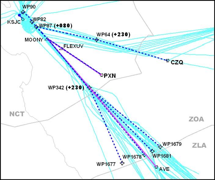
40 The figure below illustrates the mitigation of the level-offs seen in current tracks (blue) in the proposed procedure (dashed red). RAIDR Sample Arrival Profile Projected annual savings are estimated in the table below. Distance savings are associated with a reduction in excess fuel loading due to flight planning for legacy procedures. Profile savings are associated with fuel burn reduction due to the removal of level segments along the flight path. (Gallons) Carbon Savings (Metric Tons) Distance $0 Profile $640,000 - $1.92M Distance 0 Profile 231, ,000 Distance 0 Profile 2,310-6, Panoche (PXN) STAR The published PXN STAR is an arrival procedure from the southeast to OAK, with 49% of all OAK arrivals using it. The lateral path of the proposed RNAV OPD STAR closely follows historical track data. The procedure as flown today has an inefficient vertical profile with costly level-offs. 36
41 The following figure illustrates the published procedure (solid red) and the proposed routes (dashed blue), as well as current tracks (pink). The proposed PXN RNAV STAR overlays the lateral path of the conventional STAR from the Gorman (GMN) VOR and alters slightly the path from Avenal (AVE). This STAR terminates at a waypoint which accommodates multiple transitions to OAK. The RNAV STAR does not impact the Lemoore SAA. 37
42 The figure below illustrates the mitigation of the level-offs seen in current tracks (blue) in the proposed procedure (dashed red). PXN Sample Arrival Profile Projected annual savings are estimated in the table below. Distance savings are associated with a reduction in excess fuel loading due to flight planning for legacy procedures. Profile savings are associated with fuel burn reduction due to the removal of level segments along the flight path. (Gallons) Carbon Savings (Metric Tons) Distance $0 Profile $784,000 - $2.35M Distance 0 Profile 283, ,000 Distance 0 Profile 2,830-8, Manteca (ECA) STAR The published Manteca (ECA) STAR is used when OAK is in a Runways 11 and 09 configuration and is utilized less than 1% of the time. The procedure shares a competing flight path with the SFO LOCKE STAR and conflicts with the Sacramento (SMF) WRAPS STAR and FROGO SID. This causes the procedure to have an inefficient vertical profile and numerous level segments that increase fuel burn. 38
43 The following figure illustrates the published procedure (solid red) and the proposed routes (dashed blue), as well as current tracks (coral). FMG NCT MVA TATOO BIFFY OAL ZOA KENNO The proposed ECA RNAV STAR overlies the lateral path of the proposed MADN STAR until it reaches ECA. At ECA, the STAR then proceeds west to position the arrivals on a downwind for the east complex at OAK. The procedure will terminate with a flyover waypoint that will allow multiple RNP approaches to be designed at OAK. The proposed transition from ECA will deconflict arrivals from the SFO LOCKE STAR. The lateral path does not overlay historical flight data which will be a concern when environmental issues are considered. The transition also overflies Mt. Diablo by less than 2000 ft. which may cause excessive Terrain Awareness Warning System (TAWS) alerts to the user. The Design and Implementation Team will need to evaluate possible environmental and terrain issues surrounding this proposal. 39
44 The figure below illustrates the mitigation of the level-offs seen in current tracks (blue) in the proposed procedure (dashed red). Projected annual savings are estimated in the table below. Distance savings are associated with a reduction in excess fuel loading due to flight planning for legacy procedures. Profile savings are associated with fuel burn reduction due to the removal of level segments along the flight path. (Gallons) Carbon Savings (Metric Tons) Distance $11,000 Profile $35,000 - $104,000 Distance 4,000 Profile 12,000-37,000 Distance 40 Profile San Jose (SJC) Arrivals SJC arrivals were analyzed largely in the West Plan configuration. Eighty-five percent of SJC operations occur in this configuration. End waypoints of the STARs were designed with common points to join published approaches. One arrival procedure (JAWWS STAR) used during East Plan was evaluated for enhancements. The assumption from the Study Team is that the Development and Implementation Team will attempt to redesign approaches to merge with all proposed STARs. 40
45 4.7.1 Identified Issues The Study Team identified several operational issues related to all published STARs at SJC. Current SJC STAR procedures are outdated; actual flight tracks do not overfly the published procedures The STARs encompass inefficient vertical profiles and level segments Issues that were identified in particular STARs will be addressed in the specific descriptions of the procedures Study Team Recommendations SJC RNAV STARs The Study Team has made the following recommendations based upon these assumptions that SJC STARs will: Have a predictable repeatable path Include OPD benefits Align with current flight paths Accommodate multiple approach transitions into SJC Recommendations specific to particular procedures will be addressed in the individual descriptions of the procedures Golden Gate (GOLDN) STAR The GOLDN STAR is an arrival procedure from the north, used by 13% of all SJC jet arrivals. The published STAR is outdated with multiple transitions unused. The lateral path of the published procedure is not flown by current arrivals. The current GOLDN STAR is shared by both SFO and SJC arrivals. The Study Team identified a long level-off at LOZIT intersection. 41
46 The following figure illustrates the published procedure (solid red) and the proposed routes (dashed blue), as well as current tracks (pink). The lateral path of the proposed RNAV STAR closely follows the current arrival tracks and will provide more direct routing which will define a predictable, repeatable path. Unused transitions are eliminated in the proposed STAR which also has OPD benefits. Arrival windows were used in the vicinity of LOZIT to reduce level-offs. The proposed SJC STAR prior to LOZIT has been shifted east to laterally deconflict from the SFO arrival procedure. The Study Team developed a separate STAR for this arrival, thus procedurally deconflicting SFO and SJC arrivals. Both procedures will have optimized lateral and vertical profiles. 42
47 The figure below illustrates the mitigation of the level-offs seen in current tracks (blue) in the proposed procedure (dashed red). GOLDN Sample Arrival Profile Projected annual savings are estimated in the table below. Distance savings are associated with a reduction in excess fuel loading due to flight planning for legacy procedures. Profile savings are associated with fuel burn reduction due to the removal of level segments along the flight path. (Gallons) Carbon Savings (Metric Tons) Distance $34,000 Profile $76,000 - $228,000 Distance 12,000 Profile 28,000-83,000 Distance 130 Profile El Nido (HYP) STAR The HYP STAR is an east arrival procedure for SJC, with 35% of all SJC jet arrivals using this procedure. The current SJC HYP STAR shares the same east entry point of OAL with the OAK MADN STAR and the SFO MOD STAR. 43

48 The following figure illustrates the published procedure (solid red) and the proposed routes (dashed blue), as well as current tracks (light orange). This proposed SJC RNAV STAR overlies the lateral path of the current traffic flows. The unused OAL and FMG transitions are eliminated. New transitions have been added at KICHI intersection, HAROL intersection, and at a waypoint that accommodates BTY corridor traffic on this arrival. The result of these new entry points will be to procedurally segregate this arrival from the SFO MOD STAR and the OAK MADN STAR. Altitudes proposed on this OPD arrival vertically deconflict this procedure from the OAK PXN STAR. Convergence with northbound/southbound routes will be a factor at the initial entry points to this STAR. The STAR terminates at KLIDE intersection which serves to accommodate multiple approach transitions into SJC. 44
49 The figure below illustrates the mitigation of the level-offs seen in current tracks (blue) in the proposed procedure (dashed red). HYP Sample Arrival Profile HYP Projected annual savings are estimated in the table below. Distance savings are associated with a reduction in excess fuel loading due to flight planning for legacy procedures. Profile savings are associated with fuel burn reduction due to the removal of level segments along the flight path. (Gallons) Carbon Savings (Metric Tons) Distance $0 Profile $467,000-$1.4M Distance 0 Profile 171, ,000 Distance 0 Profile 1,680-5, ROBIE STAR The SJC ROBIE STAR is a southern arrival procedure used by 48% of all SJC jet arrivals. This procedure has an unused transition from AVE. The Study Team identified several level-offs in an evaluation of current traffic. 45
50 The following figure illustrates the published procedure (solid red) and the proposed routes (dashed blue), as well as current tracks (light orange). SJC GOALI ROBIE AVE TO RZS MAKRS This proposed SJC RNAV STAR overlies the lateral path of the current traffic flows. The unused AVE transition is eliminated. A new transition has been added at MAKRS intersection, which more closely aligns this arrival with current tracks. MAKRS transition intersects with ROBIE intersection, as requested by the facilities. This proposed STAR also employs a lateral route reduction from GOALI intersection to GILRO intersection over the published STAR. The STAR terminates at KLIDE intersection, which serves to accommodate multiple approach transitions into SJC. 46
51 The figure below illustrates the mitigation of the level-offs seen in current tracks (blue) in the proposed procedure (dashed red). ROBIE Sample Arrival Profile Projected annual savings are estimated in the table below. Distance savings are associated with a reduction in excess fuel loading due to flight planning for legacy procedures. Profile savings are associated with fuel burn reduction due to the removal of level segments along the flight path. (Gallons) Carbon Savings (Metric Tons) Distance $0 Profile $602,000-$1.8M Distance 0 Profile 217, ,000 Distance 0 Profile 2,170-6, JAWWS STAR The JAWWS STAR is a procedure used in east configuration plan at SJC, with 3% of all jet arrivals using this STAR. The published SJC STAR shares the same east entry point of OAL with other OAK and the SFO STARs. The Study Team identified several level-offs an unused transitions in an evaluation of current traffic. 47
52 The following figure illustrates the published procedure (solid red) and the proposed routes (dashed blue), as well as current tracks (light orange). FMG HAROL OAL KICHI AVE New transition from ZLA RZS This proposed SJC RNAV STAR overlays the lateral path of current traffic flows. The unused OAL, AVE and FMG transitions have been eliminated. New transitions have been added to this STAR at KICHI, MAKRS, HAROL intersections, and at a waypoint that accommodates BTY corridor. Altitudes proposed on this arrival vertically deconflict this procedure from other area STARs and incorporate OPD benefits. The proposed STAR terminates at JESEN intersection which serves to accommodate multiple RNP approach transitions into SJC Runway 12. JESEN will be the ending fix on the STAR for other approach options to SJC Runway12. A new transition from the south has been added at MAKRS intersection, which closely aligns this arrival with current tracks. The MAKRS transition intersects with the ROBIE intersection as requested by the facilities. This proposed STAR also employs a lateral route reduction from the TORCH intersection for traffic entering from the east. 48
53 The figure below illustrates the mitigation of the level-offs seen in current tracks (blue) in the proposed procedure (dashed red). JAWWS Sample Arrival Profile Projected annual savings are estimated in the table below. Distance savings are associated with a reduction in excess fuel loading due to flight planning for legacy procedures. Profile savings are associated with fuel burn reduction due to the removal of level segments along the flight path. (Gallons) Carbon Savings (Metric Tons) Distance $0 Profile $21,000-$62,000 Distance 0 Profile 8,000 23,000 Distance 0 Profile
54 4.8 Sacramento (SMF) Arrival One SMF arrival procedure was identified as a candidate for operational enhancements. The end waypoint of the STAR was designed with a common point to join published approaches. The assumption from the Study Team is that the Development and Implementation Team will attempt to redesign approaches to merge with the proposed STAR. The Study Team identified operational issues related to the WRAPS STAR at SMF: Current SMF STAR procedures are outdated; actual flight tracks do not overfly the published procedures The STAR encompasses inefficient vertical profiles and level-offs SMF WRAPS STAR has competing paths with other STARs Study Team Recommendations SMF RNAV STAR The Study Team designed the proposed SMF WRAPS STAR to: Have a predictable repeatable path Include OPD benefits Align with current flight paths Accommodate multiple approach transitions into SMF Procedurally deconflict from other area STARs WRAPS STAR The published WRAPS STAR has an inefficient vertical profile and level segments due to crossing traffic with SFO, OAK, and SJC arrivals. Actual flight tracks do not overfly the current procedure. Approximately 47% of the SMF arrivals utilize the WRAPS STAR. The WRAPS conflicts with west arrival flows to SJC, SFO and OAK airports. 50
55 The following figure illustrates the published procedure (solid purple) and the proposed routes (dashed red), as well as current tracks (pink). SMF Proposed WRAPS less than 1.2 NM difference than current procedure OPD from FL190 Current Procedure WRAPS STAR alternatives were considered, including swapping the FROGO and the WRAPS, adjusting the location east and procedurally deconflicting it from the MOD/MADN. The Study Team concluded that the proposed STAR will be procedurally deconflicted from these other area STARs. This modified STAR will provide a more predictable, repeatable path with OPD benefits. The STAR was moved east approximately seven miles to allow optimization of these Northern California STARs. 51
56 The figure below illustrates the mitigation of the level-offs seen in current tracks (blue) in the proposed procedure (dashed red). WRAPS Sample Arrival Profile Projected annual savings are estimated in the table below. Distance savings are associated with a reduction in excess fuel loading due to flight planning for legacy procedures. Profile savings are associated with fuel burn reduction due to the removal of level segments along the flight path. (Gallons) Carbon Savings (Metric Tons) Distance ($79,000) Profile $101,000-$303,000 Distance (29,000) Profile 36, ,000 Distance (290) Profile 360-1,090 52
57 4.9 Initial Concepts and Recommendations Terminal GROAN Holding NCT does extensive low-altitude delay vectoring close to SFO for sequencing in Instrument Meteorological Conditions (IMC). Excessive fuel consumption is associated with low-altitude delay vectoring. Industry has indicated that it would be preferable to hold at higher altitudes than to be vectored low and slow into the airport. 54 NM flying distance GROAN-SFO SFO GROAN MOD CEDES 53
58 The graph below demonstrates increase in vector distance relative to aircraft count and time of day on the MOD arrival flow. On October 1, 2010, from Z, 21 aircraft were vectored 1,286 NM total (approximately 61 NM per aircraft) Vector Distance/Counts vs Time Count Avg Vector Dist 1,286 NM of vectoring Vector Distance Aircraft Count :00 12:00 13:00 14:00 15:00 16:00 17:00 18:00 19:00 20:00 21:00 22:00 23:00 00:00 01:00 02:00 03:00 04:00 05:00 06:00 07:00 10/01/ /02/2010 Date/Time (UTC) The creation of holding at GROAN intersection would potentially reduce delay vectoring, provide more efficient delivery to SFO, reduce fuel costs associated with delay vectoring, and have a predictable holding pattern. The Study Team recommendation is to publish a GROAN holding pattern and establish a conditional use airspace agreement between NCT and ZOA to help alleviate the extensive delay vectoring. 54
59 Projected annual savings are estimated in the table below. The Study Team assumed that the same amount of time in holding would occur, but would occur at higher altitudes and at a faster speed. Total $949,000 - $1.3M (Gallons) Carbon Savings (Metric Tons) Total 343, ,000 Total 3,430-4, Enhance San Jose Runway 12 Operations Aircraft flying the SJC ILS or RNP AR Runway 12 approaches are constrained by SFO s Runway 28 arrivals and Runway 10 departures. NCT asked the Study Team to investigate moving the SJC Runway 12 Final Approach Fix (FAF) closer to SJC. The Study Team requested that AeroNav Products (TERPS Division) at OKC conduct a preliminary analysis of this issue; AeroNav Products determined the SJC Runway 12 FAF could be moved 0.94 NM closer to the runway. NCT was provided this information and will determine if this enhancement is necessary. 55
60 A depiction of the traffic flows between SJC and SFO is shown below: * Graphic depicts two individual days of traffic Prop (T/P) RNAV STAR to OAK Runway 27 NCT vectors turbo prop aircraft off the published OAK PXN/MADN STARs to separate them from the OAK turbo jet arrivals. NCT controllers requested the Study Team design a parallel OAK RNAV STAR that would segregate turbo prop aircraft arriving Runway 27 from Runway 29 jet arrivals. The proposed OAK turbo prop STAR segregates props from jets, reducing off-route vectoring and speed restrictions, accommodating multiple approach transitions to Runway 27, and potentially increasing throughput. 56
61 The following figure illustrates the proposed turbo prop STAR (dashed teal) and the proposed turbo jet STAR (solid blue), as well as current tracks (coral) San Francisco CUIT and Oakland SLNT The SFO CUIT and OAK SLNT SIDs are noise-abatement procedures that are used for departures between 2200 and 0700 local over the San Francisco Bay. These departures join a common path between 5.5 and 7.5 NM from the departure end of the runways. These two routes are procedurally conflicted and do not support independent operations. The heaviest demand for departures is between the hours 0600 and 0700 local time, resulting in ground holds for conflicting traffic. The Study Team investigated lateral and vertical resolutions in an attempt to deconflict these routes. Due to local noise abatement requirements, the Study Team was unable to determine a way to laterally deconflict the routes. Significant time was spent attempting to deconflict these as RNAV routes with vertical assignments (at or above vs. at or below altitudes). However, due to obstacle clearance requirements, RNAV leg length/climb gradient criteria, and separation minima, the Study Team determined the limits of this design to be outside of safe tolerances. The Study Team recommends developing both of these routes as RNAV SIDs with vertical profiles. These routes will offer repeatable and predictable paths but will not be procedurally deconflicted. These RNAV SIDs will require coordination between OAK and SFO. 57
62 OAK SFO 58
63 4.10 Initial Concepts and Recommendations En Route Proposed Study Team Q-Route No published route exists on the north side of R-2508 (Edwards Range Complex). Although J110, a jet route, is defined through R-2508 from CZQ to FUZZY, this route is often unavailable due to military activity within the Special Activity Airspace (SAA). ZOA has little insight into the scheduling of military activity in R When J110 is unavailable, departure aircraft from San Francisco Bay Area airports are vectored around the north side of R-2508 via LIDAT intersection and J92 to BTY as shown in the graphic below. Alternate Study Team Q Route LIDAT Proposed Q Route J110 The Study Team has proposed the creation of a Q-Route from west to east that proceeds around the north side of R This Q-Route would provide a predictable, repeatable flight path around R-2508 when J110 is unavailable due to military activity. The benefits of a Q-Route around R-2508 are: Reduction in ATC complexity (vectoring and communications) Accommodation of last minute route changes if J110 becomes unavailable Alignment of current flight tracks to a defined routing Provision for a shorter route than current operations Facilitation of better fuel planning 59
64 Projected annual savings are estimated in the table below. (Gallons) Carbon Savings (Metric Tons) Total $380,000 Total 138,000 Total 1, Dual Arrival Routes There is only one jet arrival route to SFO from the north. Consequently, throughput can be restricted; it is difficult to maintain arrival pressure on the airport. From the east, the MOD STAR is the primary arrival route. The YOSEM STAR, an ATCassigned offload route, is used sparingly to relieve pressure on the MOD STAR. 60
 and current departure tracks (light orange). GOLDN MOD YOSEM Proposed dual route to parallel GOLDN STAR No solution was proposed for dual arrival routes to SFO from the north.")
65 The image below depicts the Study Team-proposed GOLDN and MOD (dashed green), a hypothetical northern arrival route (solid purple), and the published YOSEM (solid red), as well as current arrival tracks (light green) and current departure tracks (light orange). GOLDN MOD YOSEM Proposed dual route to parallel GOLDN STAR No solution was proposed for dual arrival routes to SFO from the north. Due to numerous issues such as route length and environmental concerns, the Study Team did not pursue any solution Los Angeles Arrivals from the Far East LAX arrivals from the Far East are vectored inland over AVE VOR for sequencing with other LAX arrivals departing from within ZOA and points farther north. Mixing both the Far East and ZOA internal LAX arrivals creates sequencing complexity within some ZOA high altitude en route sectors, having a causal effect on volume and congestion over AVE. 61
66 The graphic below depicts current oceanic routes to AVE (solid purple), current oceanic tracks (light blue), and proposed routes to San Marcus (RZS) and Ventura (VTU) (dashed red). AVE RZS LAX The Study Team proposes development of an ATC assigned offshore route from the ZOA Oceanic Control Boundary (OCB) to LAX via VTU VOR and the SADDE 6 arrival. This route would join the published SADDE 6 STAR transition at RZS VOR. This offshore route may provide for aircraft arriving from the Far East to remain at higher cruise altitudes for a longer period of time and may afford OPD-like benefits prior to RZS or VTU VORs. Potential benefits from the development of an offshore route to LAX from the Far East are: Efficient use of offshore airspace over Pacific Ocean Reduction of congestion and complexity over AVE Potential additional slots over AVE for LAX arrivals Potential reduction of vectoring/holding/ground delays for LAX arrivals Aircraft could receive OPD-like benefits from cruise altitude to RZS/VTU 62
67 Projected annual savings are estimated in the table below. Distance savings are associated with a reduction in excess fuel loading due to flight planning for legacy procedures. (Gallons) Carbon Savings (Metric Tons) Total $366,000 Total 132,000 Total 1, Traffic Management Advisor Issues The National TMA Program Office visited Northern California in December 2010 with the dual purposes to assist ZOA and NCT with the adaptation of TMA and to identify possible enhancements to improve efficiency at SFO. ACM was identified as an enhancement that would enable first-tier En Route facilities to meter traffic more efficiently. ZOA sectors adjust spacing between SFO arrivals using a combination of airborne holding, radar vectors, and speed control. TMA without ACM is not sufficient to effectively manage arrival volume, and ZOA must implement Miles-in-Trail (MIT) to adjacent facilities to accommodate flow control. MIT restrictions make it difficult for the ZOA Traffic Management Unit (TMU) to accurately meet the Airport Arrival Rate (AAR). TMA with ACM enables a more dynamic and accurate picture of Traffic Flow Management (TFM). The TMA Program Office has prioritized the introduction of ACM to ZOA and surrounding centers. The Study Team agrees that the introduction of ACM is necessary to increase the efficiency of SFO operations Lack of Radar Coverage at Truckee, Tahoe Valley, Mammoth, and Bishop Radar coverage below 18,000 feet mean sea level (MSL) is limited at TRK, TVL, MMH, and BIH, which are all located within the Sierra Nevada Mountain range. An en route surveillance radar located at Fallon, NV, generally provides the most optimal surveillance for these four airports; however, the Fallon radar cannot be used to provide terminal-like radar services for arriving and departing aircraft. Procedures for aircraft arriving and departing from these four airports are limited to one in, one out for aircraft on instrument flight plans. 63


68 TRK TVL MMH BIH No solution was proposed for addressing the lack of surveillance at TRK, TVL, MMH, and BIH as this would entail projected costs outside the scope of OAPM for the installation of new surveillance equipment. Current technology to address the lack of surveillance would require that one of three types of surveillance would be required which costs over and above the scope of OAPM. The Study Team recommends that when prioritization decisions are being made for Automatic Dependent Surveillance Broadcast (ADS-B) and Wide-Area Multilateration (WAM), considerations be given to these airports for potential benefits. 64
69 4.11 Issues Tracked and Recorded San Francisco SOIA The Study Team received input regarding Simultaneous Offset Instrument Approaches (SOIA) at SFO from NCT facility personnel. Specifically, the current SFO SOIA minimums are stated as at least a ceiling of 2,100 feet and visibility of 4 NM at SFO. NCT personnel would like to see a RNP-like SOIA approach developed with lower minimums. Currently a national task force within the FAA is addressing improving capacity at SFO, including optimizing SOIA at SFO. Below is a depiction of the lateral and vertical components of the SFO SOIA procedure. Example graphic only 65

70 Class B Excursions Twelve percent of aircraft exited and re-entered the SFO Class B Airspace in As an example, during Runway 10 operations on January 21, 2010, 30% of aircraft exited the Class B airspace. Resolving this issue would enhance operational safety and reduce controller workload. A side depiction of the SFO Class B with Runway 10 arrivals to SFO on January 21, 2010 is shown below. While a potential solution of re-evaluating the Class B structure could mitigate this issue, this issue is considered outside the scope of OAPM. Another solution would be amending the procedures to ensure containment within the current Class B structure. The Northern California TRACON has recently amended the current Runway 10 approach to stay inside the Class B airspace Mather RNAV STAR There is a proposed RNAV STAR that had been previously developed for Mather (MHR) airport. The Study Team was asked to look into the timeline for the publication of the procedure. As of April 2011, the Study Team was advised that the publication date for this procedure is January Reid-Hillview and San Jose Airport Interactions Reid-Hillview (RHV) and San Jose (SJC) simultaneous IFR operations are interconnected due to the proximity of the airports. The airports are located less than 3 NM apart. Due to current regulations, these airports must be treated as a single airport in IFR operations. 66
Optimization of Airspace and Procedures in the Metroplex
 Optimization of Airspace and Procedures in the Metroplex Administration SoCal Metroplex Project Overview Brief To: By: Los Angeles World Airport Rob Henry, Manager SoCal Metroplex Jose Gonzalez, SoCal
Federal Aviation Administration. Optimization of Airspace and Procedures in the Metroplex (OAPM) Study Team Final Report Charlotte Metroplex
 Study Team Final Report Charlotte Metroplex") Administration Optimization of Airspace and Procedures in the Metroplex (OAPM) Study Team Final Report Charlotte Metroplex Table of Contents 1 Background 1 2 Purpose of the Charlotte OST Effort 1 3 OST
Administration Optimization of Airspace and Procedures in the Metroplex (OAPM) Study Team Final Report Charlotte Metroplex Table of Contents 1 Background 1 2 Purpose of the Charlotte OST Effort 1 3 OST
Cleveland/Detroit Metroplex
 Federal Aviation Administration Cleveland/Detroit Metroplex Optimization of Airspace and Procedures Study Team Final Report May 2014 By Cleveland/Detroit Metroplex Study Team Table of Contents 1 Background
Federal Aviation Administration. Optimization of Airspace and Procedures in the Metroplex (OAPM) Study Team Final Report Atlanta Metroplex
 Study Team Final Report Atlanta Metroplex") Federal Aviation Administration Optimization of Airspace and Procedures in the Metroplex (OAPM) Study Team Final Report Atlanta Metroplex Table of Contents 1 Background 1 2 Purpose of Atlanta Team Effort
Federal Aviation Administration Optimization of Airspace and Procedures in the Metroplex (OAPM) Study Team Final Report Atlanta Metroplex Table of Contents 1 Background 1 2 Purpose of Atlanta Team Effort
PBN AIRSPACE CONCEPT WORKSHOP. SIDs/STARs/HOLDS. Continuous Descent Operations (CDO) ICAO Doc 9931
 ICAO Doc 9931") International Civil Aviation Organization PBN AIRSPACE CONCEPT WORKSHOP SIDs/STARs/HOLDS Continuous Descent Operations (CDO) ICAO Doc 9931 Design in context Methodology STEPS TFC Where does the traffic
International Civil Aviation Organization PBN AIRSPACE CONCEPT WORKSHOP SIDs/STARs/HOLDS Continuous Descent Operations (CDO) ICAO Doc 9931 Design in context Methodology STEPS TFC Where does the traffic
Have Descents Really Become More Efficient? Presented by: Dan Howell and Rob Dean Date: 6/29/2017
 Have Descents Really Become More Efficient? Presented by: Dan Howell and Rob Dean Date: 6/29/2017 Outline Introduction Airport Initiative Categories Methodology Results Comparison with NextGen Performance
2 Purpose and Need. 2.1 The Need for the CLT OAPM Project Description of the Problem
 2 Purpose and Need Under NEPA, an Environmental Assessment (EA) must describe the purpose and need for the Proposed Action. The following sections discuss the need for the Proposed Action and provide specific
Name of Customer Representative: Bruce DeCleene, AFS-400 Division Manager Phone Number:
 Phase I Submission Name of Program: Equivalent Lateral Spacing Operation (ELSO) Name of Program Leader: Dr. Ralf Mayer Phone Number: 703-983-2755 Email: rmayer@mitre.org Postage Address: The MITRE Corporation,
Appendix B Ultimate Airport Capacity and Delay Simulation Modeling Analysis
 Appendix B ULTIMATE AIRPORT CAPACITY & DELAY SIMULATION MODELING ANALYSIS B TABLE OF CONTENTS EXHIBITS TABLES B.1 Introduction... 1 B.2 Simulation Modeling Assumption and Methodology... 4 B.2.1 Runway
(Presented by the United States)
") International Civil Aviation Organization 31/07/09 North American, Central American and Caribbean Office (NACC) Tenth Meeting of Directors of Civil Aviation of the Central Caribbean (C/CAR/DCA/10) Grand
International Civil Aviation Organization 31/07/09 North American, Central American and Caribbean Office (NACC) Tenth Meeting of Directors of Civil Aviation of the Central Caribbean (C/CAR/DCA/10) Grand
Analysis of Operational Impacts of Continuous Descent Arrivals (CDA) using runwaysimulator
 using runwaysimulator") Analysis of Operational Impacts of Continuous Descent Arrivals (CDA) using runwaysimulator Camille Shiotsuki Dr. Gene C. Lin Ed Hahn December 5, 2007 Outline Background Objective and Scope Study Approach
Analysis of Operational Impacts of Continuous Descent Arrivals (CDA) using runwaysimulator Camille Shiotsuki Dr. Gene C. Lin Ed Hahn December 5, 2007 Outline Background Objective and Scope Study Approach
Design Airspace (Routes, Approaches and Holds) Module 11 Activity 7. European Airspace Concept Workshops for PBN Implementation
 Module 11 Activity 7. European Airspace Concept Workshops for PBN Implementation") Design Airspace (Routes, Approaches and Holds) Module 11 Activity 7 European Airspace Concept Workshops for PBN Implementation Design in Context TFC Where does the traffic come from? And when? RWY Which
Design Airspace (Routes, Approaches and Holds) Module 11 Activity 7 European Airspace Concept Workshops for PBN Implementation Design in Context TFC Where does the traffic come from? And when? RWY Which
Air Navigation Bureau ICAO Headquarters, Montreal
 Performance Based Navigation Introduction to PBN Air Navigation Bureau ICAO Headquarters, Montreal 1 Performance Based Navigation Aviation Challenges Navigation in Context Transition to PBN Implementation
Optimized Profile Descents A.K.A. CDA A New Concept RTCA Airspace Working Group
 Optimized Profile Descents A.K.A. CDA A New Concept RTCA Presented to Environmental Working Group December 05, 2007 Outline RTCA Charter and Terms of Reference Objectives Membership and Organization Activities
Continuous Descent? And RNAV Arrivals
 Continuous Descent? And RNAV Arrivals From an ATC Perspective Presentation to: CDA Workshop GA Tech Name: Don Porter RNP Project Lead FAA, RNAV RNP Group Date: 18 April 2006 My Background 22 years Terminal
Federal Aviation. Administration. FAA Overview. Federal Aviation. Administration
 Presented to: AFCEA International Los Angeles By: William C. Withycombe Regional Administrator, Western-Pacific Region Date: Overview! Major Safety Initiatives! Organizational Structure! Destination 2025!
Optimization of Airspace and Procedures in the Metroplex (OAPM) Study Team Final Report Southern California Metroplex
 Study Team Final Report Southern California Metroplex") Federal Aviation Administration Optimization of Airspace and Procedures in the Metroplex (OAPM) Study Team Final Report Southern California Metroplex Table of Contents 1 Background 1 2 Purpose of Southern
Federal Aviation Administration Optimization of Airspace and Procedures in the Metroplex (OAPM) Study Team Final Report Southern California Metroplex Table of Contents 1 Background 1 2 Purpose of Southern
Updates to Procedures at St. John s International Airport
 October 10, 2017 Updates to Procedures at St. John s International Airport This document provides notice of upcoming changes to instrument procedures being implemented by NAV CANADA at the St. John s International
LAX Community Noise Roundtable Work Program A1 Review of SoCal Metroplex Proposed Procedures and Suggestions for Comment Letter.
 LAX Community Noise Roundtable Work Program A1 Review of SoCal Metroplex Proposed Procedures and Suggestions for Comment Letter July 8, 2015 Southern California Metroplex Environmental Assessment Presentation
Interim Response to Oakland Airport-Community Noise Management Forum s Recommendations
 Interim Response to Oakland Airport-Community Noise Management Forum s s Page 1 Executive Summary The Northern California airspace is very complex, with traffic arriving and departing from several major
International Civil Aviation Organization. PBN Airspace Concept. Victor Hernandez
 International Civil Aviation Organization PBN Airspace Concept Victor Hernandez Overview Learning Objective: at the end of this presentation you should Understand principles of PBN Airspace Concept 2 Gate
THE NATIONAL ACADEMIES PRESS
 THE NATIONAL ACADEMIES PRESS This PDF is available at http://nap.edu/23574 SHARE NextGen for Airports, Volume 1: Understanding the Airport s Role in Performance-Based Navigation: Resource Guide DETAILS
NextGen Priorities: Multiple Runway Operations & RECAT
 NextGen Priorities: Multiple Runway Operations & RECAT May 2018 Presented by Paul Strande & Jeffrey Tittsworth Federal Aviation Administration National Airspace System Today Air traffic services for the
2 Purpose and Need. 2.1 The Need for the Proposed Action Description of the Problem
 2 Purpose and Need The FAA is preparing this EA to evaluate the potential environmental impacts associated with implementation of new RNAV-defined IFPs for the Atlanta Metroplex (Proposed Action). According
Surveillance and Broadcast Services
 Surveillance and Broadcast Services Benefits Analysis Overview August 2007 Final Investment Decision Baseline January 3, 2012 Program Status: Investment Decisions September 9, 2005 initial investment decision:
RNP AR APCH Approvals: An Operator s Perspective
 RNP AR APCH Approvals: An Operator s Perspective Presented to: ICAO Introduction to Performance Based Navigation Seminar The statements contained herein are based on good faith assumptions and provided
Final Environmental Assessment for Northern California Optimization of Airspace and Procedures in the Metroplex
 Final Environmental Assessment for Northern California Optimization of Airspace and Procedures in the Metroplex July 2014 Prepared by: United States Department of Transportation Federal Aviation Administration
NextGen: New Technology for Improved Noise Mitigation Efforts: DFW RNAV Departure Procedures
 NextGen: New Technology for Improved Noise Mitigation Efforts: DFW RNAV Departure Procedures DFW International Airport Sandy Lancaster, Manager Noise Compatibility October 13, 2008 OUTLINE About DFW Airport
GREENER SKIES OVER SEATTLE INITIATIVE
 WRITTEN SUBMISSION OF AIR LINE PILOTS ASSOCIATION, INTERNATIONAL TO THE SUBCOMMITTEE ON AVIATION COMMITTEE ON TRANSPORTATION AND INFRASTRUCTURE UNITED STATES HOUSE OF REPRESENTATIVES ON NEXTGEN SUCCESS
POST-IMPLEMENTATION COMMUNITY IMPACT REVIEW
 POST-IMPLEMENTATION COMMUNITY IMPACT REVIEW RNAV STAR updates and RNP AR approaches at Edmonton International Airport NAV CANADA 77 Metcalfe Street Ottawa, Ontario K1P 5L6 January 2018 The information
POST-IMPLEMENTATION COMMUNITY IMPACT REVIEW
 POST-IMPLEMENTATION COMMUNITY IMPACT REVIEW RNAV STAR updates and RNP AR approaches at Winnipeg James Armstrong Richardson International Airport NAV CANADA 77 Metcalfe Street Ottawa, Ontario K1P 5L6 November
POST-IMPLEMENTATION COMMUNITY IMPACT REVIEW
 POST-IMPLEMENTATION COMMUNITY IMPACT REVIEW RNAV STAR updates and RNP AR approaches at Halifax Stanfield International Airport NAV CANADA 77 Metcalfe Street Ottawa, Ontario K1P 5L6 November 2017 The information
COMMUNITY NOISE MITIGATION SUGGESTIONS
 COMMUNITY NOISE MITIGATION SUGGESTIONS Toronto Pearson is one of North America's fastest growing global hub airports, handling nearly 40 million passengers today, and well on its way to reaching greater
2012 Performance Framework AFI
 2012 Performance Framework AFI Nairobi, 14-16 February 2011 Seboseso Machobane Regional Officer ATM, ESAF 1 Discussion Intro Objectives, Metrics & Outcomes ICAO Process Framework Summary 2 Global ATM Physical
PBN and airspace concept
 PBN and airspace concept 07 10 April 2015 Global Concepts Global ATM Operational Concept Provides the ICAO vision of seamless, global ATM system Endorsed by AN Conf 11 Aircraft operate as close as possible
Nav Specs and Procedure Design Module 12 Activities 8 and 10. European Airspace Concept Workshops for PBN Implementation
 Nav Specs and Procedure Design Module 12 Activities 8 and 10 European Airspace Concept Workshops for PBN Implementation Learning Objectives By the end of this presentation you should understand: The different
System Oriented Runway Management: A Research Update
 National Aeronautics and Space Administration System Oriented Runway Management: A Research Update Gary W. Lohr gary.lohr@nasa.gov Senior Research Engineer NASA-Langley Research Center ATM 2011 Ninth USA/EUROPE
Learning Objectives. By the end of this presentation you should understand:
 Designing Routes 1 Learning Objectives By the end of this presentation you should understand: Benefits of RNAV Considerations when designing airspace routes The basic principles behind route spacing The
FLIGHT OPERATIONS PANEL (FLTOPSP)
") International Civil Aviation Organization FLTOPSP/1-WP/3 7/10/14 WORKING PAPER FLIGHT OPERATIONS PANEL (FLTOPSP) FIRST MEETING Montréal, 27 to 31 October 2014 Agenda Item 4: Active work programme items
International Civil Aviation Organization FLTOPSP/1-WP/3 7/10/14 WORKING PAPER FLIGHT OPERATIONS PANEL (FLTOPSP) FIRST MEETING Montréal, 27 to 31 October 2014 Agenda Item 4: Active work programme items
Mr. Chairman, Members of the Committee, I am Chet Fuller, President GE Aviation
 Mr. Chairman, Members of the Committee, I am Chet Fuller, President GE Aviation Systems, Civil. Thank you for the opportunity to testify before the Subcommittee today on the issue of Area Navigation (RNAV)
Washington Dulles International Airport (IAD) Aircraft Noise Contour Map Update
 Aircraft Noise Contour Map Update") Washington Dulles International Airport (IAD) Aircraft Noise Contour Map Update Ultimate ASV, Runway Use and Flight Tracks 4th Working Group Briefing 8/13/18 Meeting Purpose Discuss Public Workshop input
Washington Dulles International Airport (IAD) Aircraft Noise Contour Map Update Ultimate ASV, Runway Use and Flight Tracks 4th Working Group Briefing 8/13/18 Meeting Purpose Discuss Public Workshop input
TWELFTH AIR NAVIGATION CONFERENCE
 International Civil Aviation Organization 19/3/12 WORKING PAPER TWELFTH AIR NAVIGATION CONFERENCE Montréal, 19 to 30 November 2012 (Presented by the Secretariat) EXPLANATORY NOTES ON THE AGENDA ITEMS The
Making the World A better place to live SFO
 Making the World A better place to live SFO August 2016 Emissions Reduction Roadmap Industry is strongly committed to achieve the targets Only with several lines of actions it is possible to reach 2020
UPDATE ON THE 6 IDEAS (1-4) NAV CANADA
 NAV CANADA") UPDATE ON THE 6 IDEAS (1-4) THE 6 INITIATIVES 1. New approaches for night-time operations - Implemented 2. New departure procedures for night-time operations - Implemented 3. Increased downwind arrival
UPDATE ON THE 6 IDEAS (1-4) THE 6 INITIATIVES 1. New approaches for night-time operations - Implemented 2. New departure procedures for night-time operations - Implemented 3. Increased downwind arrival
NextGen AeroSciences, LLC Seattle, Washington Williamsburg, Virginia Palo Alto, Santa Cruz, California
 NextGen AeroSciences, LLC Seattle, Washington Williamsburg, Virginia Palo Alto, Santa Cruz, California All Rights Reserved 1 Topics Innovation Objective Scientific & Mathematical Framework Distinctions
Supplemental Proposals to Revising the
 Presentation Summary of the Supplemental Proposals to Revising the Northern California Metroplex For Alameda County/Contra Costa County NEXTGEN SUBCOMMITTEE FOR THE OAKLAND AIRPORT/COMMUNITY NOISE FORUM
Honeywell.com PBN Concepts Krakow, Poland
 PBN Concepts Krakow, Poland EPKK (KRK) Current Operational Environment Current Operational Environment : Runways: 07/25 8,366 ft (2550m) Approaches: ILS or LOC 25 RNAV (GNSS) 07, 25 VOR 07, 25 NDB 25 Departure
VATUSA-VATNZ-VATPAC OCEANIC PARTNERSHIP OAKLAND OCEANIC FSS GENERAL SOP 1 OCT 2012
 VATUSA-VATNZ-VATPAC OCEANIC PARTNERSHIP EFFECTIVE OAKLAND OCEANIC FSS GENERAL SOP 1 OCT 2012 I. PURPOSE With the establishment of the VATNZ division of the Oceania Region on 1 January 2007, the Oakland
Naples Airport Authority Board of Commissioners and Noise Compatibility Committee Special Meeting on Central/South Florida Metroplex
 Naples Airport Authority Board of Commissioners and Noise Compatibility Committee Special Meeting on Central/South Florida Metroplex March 16, 2017 Ted Baldwin and Robert Mentzer Metroplex Overview: From
SJC North and South Flow
 SJC North and South Flow Pre and Post OAPM Date: January 2018 Phases of Flight ATCC ARTCC ATCC 2 AviationTerms VFR- Visual Flight Rules. Pilots must maneuver to avoid clouds and are responsible for their
Project Consultant (PC) Alternative 5 Runway 22R/L RNAV Departures
 Alternative 5 Runway 22R/L RNAV Departures") VIA E-MAIL Date: To: From: Subject: Boston Technical Advisory Committee (BOS/TAC) Project Consultant (PC) Alternative 5 Runway 22R/L RNAV Departures At the February 17, 2006 BOS/TAC meeting several issues
VIA E-MAIL Date: To: From: Subject: Boston Technical Advisory Committee (BOS/TAC) Project Consultant (PC) Alternative 5 Runway 22R/L RNAV Departures At the February 17, 2006 BOS/TAC meeting several issues
Saint Petersburg-Clearwater International Airport. Airspace & Instrument Approach Analysis
 Saint Petersburg-Clearwater International Airport Airspace & Instrument Approach Analysis February 23, 2005 Jeppesen Boeing Jeppesen Government / Military Services Group Airspace Services Division AIRSPACE
New York Aviation Management Association Conference
 New York Aviation Management Association Conference Presented by: Carmine W. Gallo Federal Aviation Administration Eastern Region Regional Administrator September 14, 2016 1 The What is and Benefits of
Operators may need to retrofit their airplanes to ensure existing fleets are properly equipped for RNP operations. aero quarterly qtr_04 11
 Operators may need to retrofit their airplanes to ensure existing fleets are properly equipped for RNP operations. 24 equipping a Fleet for required Navigation Performance required navigation performance
Trajectory Based Operations
 Trajectory Based Operations Far-Term Concept Proposed Trade-Space Activities Environmental Working Group Operations Standing Committee July 29, 2009 Rose.Ashford@nasa.gov Purpose for this Presentation
Don-Jacques OULD FERHAT VP Airspace and Airlines Services. Airbus. PBN Safety programs
 Don-Jacques OULD FERHAT VP Airspace and Airlines Services Airbus PBN Safety programs Long term cooperation with China Complex projects in China RNP AR at Kathmandu airport Cochin : First RNP APCH in India
NextGen Trajectory-Based Operations Status Update Environmental Working Group Operations Standing Committee
 NextGen Trajectory-Based Operations Status Update Environmental Working Group Operations Standing Committee May 17, 2010 Rose Ashford Rose.Ashford@nasa.gov 1 Outline Key Technical Concepts in TBO Current
ICAO Big Data Project ADS-B Data as a source for analytical solutions for traffic behaviour in airspace
 ICAO Big Data Project ADS-B Data as a source for analytical solutions for traffic behaviour in airspace ICAO/IATA/CANSO PBN/2 San Jose December 8, 2016 Big Data process Quantitative Quantitative / Qualitative
Safety / Performance Criteria Agreeing Assumptions Module 10 - Activities 5 & 6
 Safety / Performance Criteria Agreeing Assumptions Module 10 - Activities 5 & 6 European Airspace Concept Workshops for PBN Implementation Why have safety and performance criteria? Measure performance
ENRI International Workshop on ATM/CNS
 NextGen Next Generation Air Transportation System ENRI International Workshop on ATM/CNS Presented by: Jay Merkle Manager, System Engineering Integration, NextGen and Operations Planning Date: 12 November
LONG BEACH, CALIFORNIA
 LONG BEACH, CALIFORNIA 1 LONG BEACH, CALIFORNIA Airport Capacity Session Kent Duffy Senior Airport Planner Federal Aviation Administration kent.duffy@faa.gov 2 Agenda FAA Airport Capacity Guidance Airport
4.1 This document outlines when a proposal for a SID Truncation may be submitted and details the submission requirements.
 Safety and Airspace Regulation Group 13 May 2014 Policy Statement STANDARD INSTRUMENT DEPARTURE TRUNCATION POLICY 1 Introduction 1.1 This Policy Statement (PS) is intended to provide guidance to ANSPs
Atlantic Interoperability Initiative to Reduce Emissions AIRE
 ICAO Colloquium on Aviation and Climate Change ICAO ICAO Colloquium Colloquium on Aviation Aviation and and Climate Climate Change Change Atlantic Interoperability Initiative to Reduce Emissions AIRE Célia
Colombian PBN implementation: El Dorado case study
 Colombian PBN implementation: El Dorado case study SDM WORKSHOP ON PBN 19.10.2017 XAVIER OUTTERS SME & PROJECT MANAGER NAVBLUE SAS Electronic Flight Bag Dispatch Pre-flight Airport Databases - FlySmart+
TWELFTH WORKING PAPER. AN-Conf/12-WP/137. International ICAO. developing RNAV 1.1. efficiency. and terminal In line.
 International Civil Aviation Organization WORKING PAPER 31/10/12 English only TWELFTH AIR NAVIGATION CONFERENCE Montréal, 19 to 30 November 2012 Agenda Item 5: Efficient flight paths through trajectory-based
IRISH AVIATION AUTHORITY DUBLIN POINT MERGE. Presented by James O Sullivan PANS-OPS & AIRSPACE INSPECTOR Irish Aviation Authority
 IRISH AVIATION AUTHORITY DUBLIN POINT MERGE Presented by James O Sullivan PANS-OPS & AIRSPACE INSPECTOR Irish Aviation Authority 2012 Holding Holding Before Point Merge No Pilot anticipation of distance
Doncaster Sheffield Airport Airspace Change Proposal for the Introduction of RNAV (GNSS) Departure and Approach Procedures ANNEX B TO PART B
 Departure and Approach Procedures ANNEX B TO PART B") Doncaster Sheffield Airport Airspace Change Proposal for the Introduction of RNAV (GNSS) Departure and Approach Procedures ANNEX B TO PART B ANNEX B TO PART B: Runway 20 Westerly Departure UPTON 2B 2 Contents
Doncaster Sheffield Airport Airspace Change Proposal for the Introduction of RNAV (GNSS) Departure and Approach Procedures ANNEX B TO PART B ANNEX B TO PART B: Runway 20 Westerly Departure UPTON 2B 2 Contents
Required Navigation Performance (RNP) in the United States
 in the United States") Required Navigation Performance (RNP) in the United States Overview FAA Roadmap for Performance-Based Navigation Moving to Performance-Based Navigation (RNAV and RNP) Definitions Operational attributes
Required Navigation Performance (RNP) in the United States Overview FAA Roadmap for Performance-Based Navigation Moving to Performance-Based Navigation (RNAV and RNP) Definitions Operational attributes
Global ATM System. ~ Performance framework ~ H.V. SUDARSHAN, Technical Officer International Civil Aviation Organization
 SIP/2009-WP/8 Business case Global ATM System ~ Performance framework ~ H.V. SUDARSHAN, Technical Officer International Civil Aviation Organization Workshop on the Development of Business Case for the
AERONAUTICAL SERVICES ADVISORY MEMORANDUM (ASAM) Focal Point: Gen
 Focal Point: Gen") Page 1 of 6 1 INTRODUCTION Each route shall be assigned a designator that is unique for that aerodrome. The designator shall be defined in accordance with Annex 11, Appendix 3. In addition, the first 4
Page 1 of 6 1 INTRODUCTION Each route shall be assigned a designator that is unique for that aerodrome. The designator shall be defined in accordance with Annex 11, Appendix 3. In addition, the first 4
Efficiency and Automation
 Efficiency and Automation Towards higher levels of automation in Air Traffic Management HALA! Summer School Cursos de Verano Politécnica de Madrid La Granja, July 2011 Guest Lecturer: Rosa Arnaldo Universidad
Redesign Traffic Routes Review the Present Route Structure and Procedures for Inefficiencies
 AIRSPACE DESIGN 7 AIRSPACE DESIGN 7 7 AIRSPACE DESIGN This chapter describes the FAA s initiatives to increase airspace capacity by restructuring airspace. Airspace issues may be identified from within
Safety Enhancement RNAV Safe Operating and Design Practices for STARs and RNAV Departures
 Safety Enhancement Action: Implementers: Statement of Work: Safety Enhancement 213.5 RNAV Safe Operating and Design Practices for STARs and RNAV Departures To mitigate errors on Standard Terminal Arrival
LAMP 2 - FASI(S) Network
 Network") Future Airspace Strategy Implementation South: ATS Route Network managed by NERL under London Airspace Management Programme 2 LAMP 2 - FASI(S) Network Stage 1 Assessment Meeting Friday 23 rd February 2018
Future Airspace Strategy Implementation South: ATS Route Network managed by NERL under London Airspace Management Programme 2 LAMP 2 - FASI(S) Network Stage 1 Assessment Meeting Friday 23 rd February 2018
July 20, To Whom It May Concern,
 July 20, 2016 To Whom It May Concern, Please find attached the Towns of Portola Valley, Los Altos Hills and Woodside s response to the May 2016 FAA report entitled Northern California Initiative Executive
MONTEREY REGIONAL AIRPORT MASTER PLAN TOPICAL QUESTIONS FROM THE PLANNING ADVISORY COMMITTEE AND TOPICAL RESPONSES
 MONTEREY REGIONAL AIRPORT MASTER PLAN TOPICAL QUESTIONS FROM THE PLANNING ADVISORY COMMITTEE AND TOPICAL RESPONSES Recurring topics emerged in some of the comments and questions raised by members of the
Phase 1 PROJECT CONSULTANT SCOPE OF SERVICES AMENDMENT #1 FOR BOS/TAC REVIEW
 Phase 1 PROJECT CONSULTANT SCOPE OF SERVICES AMENDMENT #1 FOR BOS/TAC REVIEW September 30, 2005 Project Consultant Amendment #1 DRAFT FOR BOS/TAC REVIEW 9/30/2005 TABLE OF CONTENTS 1 STUDY DESIGN... 3
Considerations for Facility Consolidation
 Considerations for Facility Consolidation ATC Guild, New Delhi, India October 21, 2010 Mimi Dobbs Overview Why consider consolidation? Co location vs Consolidation Consolidating Methodologies Areas to
Airport Characterization for the Adaptation of Surface Congestion Management Approaches*
 MIT Lincoln Laboratory Partnership for AiR Transportation Noise and Emissions Reduction MIT International Center for Air Transportation Airport Characterization for the Adaptation of Surface Congestion
Feasibility Study into increasing the altitude of the Noise Preferential Routes (NPRs) from 3000 to 4000 feet
 from 3000 to 4000 feet") Feasibility Study into increasing the altitude of the Noise Preferential Routes (NPRs) from 3000 to 4000 feet Presented by: Tom Redfern Environmental Specialist 20 th January 2016 Agenda What is a Noise
Feasibility Study into increasing the altitude of the Noise Preferential Routes (NPRs) from 3000 to 4000 feet Presented by: Tom Redfern Environmental Specialist 20 th January 2016 Agenda What is a Noise
AERONAUTICAL INFORMATION CIRCULAR 18/18
 NAV CANADA 19 JUL 18 AERONAUTICAL INFORMATION CIRCULAR 18/18 GUIDANCE FOR STANDARD TERMINAL ARRIVAL (STAR) PROCEDURES The guidance currently published in the Transport Canada Aeronautical Information Manual
Federal Aviation Administration. Air Traffic 101. By: Michael Valencia & Dianna Johnston Date: Feb. 26, 2017
 Presented to: UC Davis Aviation Symposium By: Michael Valencia & Dianna Johnston Date: Overview Part 1 Air Traffic Controllers History Safety and Navigation Terminology Air Traffic Facility Types Equipment
USE OF RADAR IN THE APPROACH CONTROL SERVICE
 USE OF RADAR IN THE APPROACH CONTROL SERVICE 1. Introduction The indications presented on the ATS surveillance system named radar may be used to perform the aerodrome, approach and en-route control service:
Aviation Safety Information Analysis and Sharing ASIAS Overview PA-RAST Meeting March 2016 ASIAS Proprietary Do Not Distribute
 Aviation Safety Information Analysis and Sharing ASIAS Overview PA-RAST Meeting March 2016 ASIAS Proprietary Do Not Distribute Updated: March 2016 2 12 How can safety be improved in an environment of near-zero
AIR TRAFFIC FLOW MANAGEMENT INDIA S PERSPECTIVE. Vineet Gulati GM(ATM-IPG), AAI
, AAI") AIR TRAFFIC FLOW MANAGEMENT INDIA S PERSPECTIVE Vineet Gulati GM(ATM-IPG), AAI AIR TRAFFIC FLOW MANAGEMENT ATFM is a service provided with the objective to enhance the efficiency of the ATM system by,
AIR TRAFFIC FLOW MANAGEMENT INDIA S PERSPECTIVE Vineet Gulati GM(ATM-IPG), AAI AIR TRAFFIC FLOW MANAGEMENT ATFM is a service provided with the objective to enhance the efficiency of the ATM system by,
The purpose of this Demand/Capacity. The airfield configuration for SPG. Methods for determining airport AIRPORT DEMAND CAPACITY. Runway Configuration
 Chapter 4 Page 65 AIRPORT DEMAND CAPACITY The purpose of this Demand/Capacity Analysis is to examine the capability of the Albert Whitted Airport (SPG) to meet the needs of its users. In doing so, this
APPENDIX D MSP Airfield Simulation Analysis
 APPENDIX D MSP Airfield Simulation Analysis This page is left intentionally blank. MSP Airfield Simulation Analysis Technical Report Prepared by: HNTB November 2011 2020 Improvements Environmental Assessment/
Atlanta NextGen PBN Activities
 Atlanta NextGen PBN Activities Presentation to: Name: Date: EWG Ops SC Meeting Jim Arrighi RNAV/RNP Group Jim Allerdice A80 May 18, 2010 0 0 Atlanta Performance Based Navigation Project Planning Seven
Captain Jeff Martin Senior Director Flight Operations Southwest Airlines
 Captain Jeff Martin Senior Director Flight Operations Southwest Airlines Southwest s Fleet Southwest achieves one of its primary competitive strengths low operating costs by operating only one aircraft
Measurement of environmental benefits from the implementation of operational improvements
 Measurement of environmental benefits from the implementation of operational improvements ICAO International Aviation and Environment Seminar 18 19 March 2015, Warsaw, Poland Sven Halle Overview KPA ASSEMBLY
Thursday, November 8, :15 p.m. 2:30 p.m. David Chetcuti Community Room Millbrae City Hall 450 Poplar Avenue Millbrae, CA 94030
 Meeting Announcement Technical Working Group Thursday, November 8, 2018 12:15 p.m. 2:30 p.m. David Chetcuti Community Room Millbrae City Hall 450 Poplar Avenue Millbrae, CA 94030 Note: To arrange an accommodation
SoCal Metroplex Study Area
 An Update on Southern California Airspace Modernization November 10, 2016 Chart Publication Date Long Beach Daugherty, John Wayne Orange County, Los Alamitos, Fullerton Municipal and Zamperini Field Airports
RNAV Departures and STAR Operations Joint Safety Analysis and Implementation Team
 and STAR Operations Joint Safety Analysis and Implementation Team Final Report Analysis and Recommendations February 12, 2015 and STAR Operations Joint Safety Analysis and Implementation Team Final Report
CONTROLLED AIRSPACE CONTAINMENT POLICY
 Safety and Airspace Regulation Group (SARG) 17 January 2014 Policy Statement 1 Overview CONTROLLED AIRSPACE CONTAINMENT POLICY 1.1 UK airspace design policy for ATS Routes, SIDs and STARs is based upon
Traffic Flow Management
 Traffic Flow Management Traffic Flow Management The mission of traffic management is to balance air traffic demand with system capacity to ensure the maximum efficient utilization of the NAS 2 Traffic
Appendix A. Meeting Coordination. Appendix A
 Appendix A Meeting Coordination Appendix A Philadelphia International Airport Noise Compatibility Program Update FAR Part 150 Noise Compatibility Program Update Report Prepared by: DMJM Aviation AECOM
Framework Brief. Edinburgh SIDs
 Framework Brief 11-Nov-2015 CAA House Edinburgh SIDs 2 Security Statement Unclassified This presentation has been approved for public distribution and publication on the CAA website. Copyright 2015 NATS/
WEST ATLANTIC ROUTE SYSTEM (WATRS) PLUS AIRSPACE REDESIGN AND SEPARATION REDUCTION INITIATIVE. (Presented by United States of America) SUMMARY
 PLUS AIRSPACE REDESIGN AND SEPARATION REDUCTION INITIATIVE. (Presented by United States of America) SUMMARY") International Civil Aviation Organization 16/10/06 CAR/SAM Regional Planning and Implementation Group (GREPECAS) Fifth Meeting of the Air Traffic Management / Communications, Navigation and Surveillance
International Civil Aviation Organization 16/10/06 CAR/SAM Regional Planning and Implementation Group (GREPECAS) Fifth Meeting of the Air Traffic Management / Communications, Navigation and Surveillance
SIMMOD Simulation Airfield and Airspace Simulation Report. Oakland International Airport Master Plan Preparation Report. Revised: January 6, 2006
 Table of Contents SIMMOD Simulation Airfield and Airspace Simulation Report Oakland International Airport Master Plan Preparation Report Revised: January 6, 2006 Produced For: 1. Simmod PRO! Description...
RNP AR and Air Traffic Management
 RNP AR and Air Traffic Management BOEING is a trademark of Boeing Management Company. Copyright 2009 Boeing. All rights reserved. Expanding the Utility of RNP AR Sheila Conway RNP AR User s Forum Wellington,