10.3 TRAIL DESIGN STANDARDS
|
|
|
- Delilah Owen
- 5 years ago
- Views:
Transcription


1 10.3 TRAIL DESIGN STANDARDS BICYCLE AND PEDESTRIAN MASTER PLAN Introduction This chapter provides guidelines to both public and private entities for the future development of various types of trails. The guidelines noted herein are based on the best practices in use throughout the United States, as well as accepted national standards for greenway facilities. The guidelines should be used with the understanding that each trail project is unique and that design adjustments will be necessary in certain situations in order to achieve the best results. Each segment shouldjuly be evaluated on a case-by-case basis, in consultation with local or state bicycle and pedestrian coordinators, a qualified engineer and a landscape architect. Should these national standards be revised in the future and result in discrepancies with this chapter, the national standards should prevail for all design decisions. Facility design is a broad topic that covers many issues. This section provides guidelines for typical greenway facilities and is not a substitute for more thorough design and engineering work. For more in-depth information and design development standards, the following publications should be consulted: Greenways: A Guide to Planning, Design and Development Island Press, Authors: Charles A. Flink and Robert Searns Trails for the Twenty-First Century Island Press, 2nd ed Authors: Charles A. Flink, Robert Searns, Kristine Olka Guide to the Development of Bicycle Facilities American Association of State Highway Transportation Officials (AASHTO), Manual on Uniform Traffic Control Devices (MUTCD) U. S. Department of Transportation, Washington, DC, Universal Access to Outdoor Recreation: A Design Guide PLAE, Inc., Berkeley, CA, North Carolina Bicycle Facilities Planning and Design Guidelines NCDOT Office of Bicycle and Pedestrian Transportation, Raleigh, NC, 1994 Chapter Ten: Design Guidelines 233
2 SPARTANBURG, SOUTH CAROLINA ADA Requirements The Americans with Disabilities Act requires that portions of greenways be accessible to persons with varying motor skills and abilities. Perhaps the best way to comprehend the importance of ADA is to understand that most of us, at some time in our life, will experience a temporary disability which will affect the way in which we make use of outdoor resources. ADA benefits all Americans by making the outdoor environment more accessible. Sustainable Design The consultant recommends the use of recycled materials and products in the construction of trails and trail facilities. Recycled materials offer design versatility, often have a long life span, and require less long-term maintenance than similar products constructed from natural materials. Recycled plastic lumber and or concrete can be used for the construction of posts and poles, and recycled aluminum can be used for signs. Whenever possible, local materials should be used for construction. Trail Details & Standards The graphics on the following pages depict greenway trail details, on-road guidelines, and typical trail amenities. They are provided as examples only, and are not intended as substitutes for professional, site-specific design and engineering work. Require hard paved surfaces of concrete to withstand high-velocity stream 234 Chapter Ten: Design Guidelines


3 BICYCLE AND PEDESTRIAN MASTER PLAN Creekside Trail (Urban Areas Only) Located only in urban areas, where right-of-way constraints and channelized streams restrict trail development to the floodway. Typically positioned directly adjacent to the stream channel and are therefore subject to frequent flooding. Parking areas near urban creeks can also be retrofitted to accommodate this type of trail. When box culverts are built along creeks on planned trail routes, they should be designed to meet with this trail type, and should have sufficient space for trail users. flows. Retaining walls or other structural elements may also be required for stable construction and to protect the trail from erosion and flood damage. The installation of railings, benches, signage, and trash receptacles, that could obstruct flow during storm events, should be carefully considered. The use of retaining walls as seat walls is one way in which nonobtrusive amenities can be included. Special consideration should be paid to the mitigation of impacts from trail construction on the natural environment. Minimum 10 wide for multi-use trails. Chapter Ten: Design Guidelines 235


4 SPARTANBURG, SOUTH CAROLINA Floodway Trail (Limited Areas) Typically positioned within the floodway, but not directly adjacent to streams; some vegetative buffer between the stream and trail should be left intact. Subject to infrequent, periodic flooding. Require paved surfaces of either asphalt or concrete depending on frequency of flooding and expected velocity of flow. Proper trail foundation (see details) will increase the longevity of the trail. No soft shoulder should be constructed due to flood considerations. All elements of the trail, including the trail tread, railings, benches, and trash receptacles, will be periodically flooded; design and materials should be carefully selected and sited accordingly. Special consideration should be paid to the mitigation of impacts from trail construction on the natural environment. Minimum 10 wide for multi-use trails. Creek Paving Details [3-0 ] TYP [12 ] SURFACE FINISH AS SPECIFIED 4 CONC. SLAB REINFORCED WITH WWM 6 SAND AGGREGATE BASE [3-0 ] TYP GAB ON [12 ] [12 ] SURFACE FINISH AS SPECIFIED AGGREGATE FILL GALVANIZED STEEL WIRE MESH GABIONS WIRED TOGETHER PREPARED SUBGRADE [2-0 ] STONE VARIES FROM GRADATION 2-12 PREPARED SUBGRADE CONCRETE PAVING ON AGGREGATE 236 Chapter Ten: Design Guidelines GABION WALL WITH STEPPED FACE


5 BICYCLE AND PEDESTRIAN MASTER PLAN Floodplain Trail Typically positioned outside the floodway, within the floodplain; significant vegetative buffer between the stream and trail should be left intact. Subject to occasional flooding, during large storm events. Paved asphalt recommended, though an aggregate stone surface may be adequate in some locations. Proper trail foundation (see details) will increase the longevity of the trail. Minimum 2 graded shoulder recommended. Minimum 10 wide for multi-use trails. Creek Paving Details LOW VELOCITY HIGH VELOCITY SURFACE FINISH AS SPECIFIED 2 ASPHALT CONCRETE SURFACE 6 AGGREGATE BASE FABRIC SEPARATOR PREPARED SUBGRADE 4 CONC. SLAB REINFORCED WITH WWM 6 SAND AGGREGATE BASE PREPARED SUBGRADE ASPHALT PAVING ON AGGREGATE BASE CONCRETE PAVING ON AGGREGATE Chapter Ten: Design Guidelines 237


6 SPARTANBURG, SOUTH CAROLINA Water Trail and Water Trail Access Sites Also known as water-based trails, paddle trails, blueways or blue trails. Typically defined as sections of rivers, creeks, wetlands, and other water bodies that are designated as routes for canoeing, kayaking, and tubing. Clearly marked access points and/or trailheads should be provided. Educational signs, directional signs, and regulatory signs should inform users of their surroundings and how to navigate the watercourse safely. Improved rapids are increasingly popular along water trails; they should only be used in areas where high usage is expected and a demand for such a facility has been established. The provision of designated picnic areas and camp sites along water trails can reduce the problem of trespassing private property along the watercourse. If a pathway from parking area to water access exceeds 1500 feet, a permanently affixed canoe or kayak stand should be positioned every 1000 feet. Informational signs containing emergency contact numbers, as well as contact numbers for the managing partner, must be displayed at the parking space area and/or within 150 feet of the access site. Access to waterway must be firm, compacted, and permanently delineated Minimum construction for facilities Lights in parking and picnic areas are recommended Maps should be provided to guide users along the watercourse and to access sites for drop-in and take-out. Natural but well maintained pathway from parking to water access: - Pathway at least 6 wide - Grass not higher that 5 - Tree overhang not lower than 14 - Grade must not exceed 20% 238 Chapter Ten: Design Guidelines (An example water trail map and guide for Shuylkill River, PA)


7 BICYCLE AND PEDESTRIAN MASTER PLAN Natural Surface Trail Also known as footpaths or hiking trails Designed to accommodate pedestrians on foot; not intended for cyclists or other wheeled users. Trail surface typically made of dirt, rock, soil, forest litter, snow, ice, pine mulch, leaf mulch, or other native materials. Preparation varies from machine-worked surfaces to those worn only by usage. May be more appropriate for ecologically sensitive areas. Provide positive drainage for trail tread without extensive removal of existing vegetation. Varies in width from 1-6 to 5. Vertical clearance should be maintained at 9. Chapter Ten: Design Guidelines 239


8 SPARTANBURG, SOUTH CAROLINA Equestrian Trail Vertical clearance for equestrians is at least 10 feet, with 12 feet preferred. A horizontal clearance should be at least five feet. Dirt or stabilized dirt is a preferred surface. Crushed granite screenings are also acceptable. Hard surfaces like asphalt and concrete are undesirable for equestrians because they can injure horses hooves. Granular stone may also present problems because loose aggregate can get stuck in hooves. Within the tread, large rocks, stumps, and other debris should be cleared. Sight distances for equestrians, who usually travel between 4 and 6 miles per hour, should be at least 100 feet. Hitching posts should be installed at rest stops, picnic areas, and rest rooms. For horseback riders, a water crossing is preferred to a high and narrow bridge. If erosion is a concern, or if water crossing is for some reason undesirable, then provide mounting blocks at the bridge, so riders can dismount and lead their horses. Equestrians should be expected to remove their horse s manure from trail surfaces. Many riders are not comfortable dismounting and taking care of this as it occurs. Therefore, equestrians should be strongly encouraged (or possibly required in exchange for use of the trail) to join fellow riders on manure clean-up days. 240 Chapter Ten: Design Guidelines


9 BICYCLE AND PEDESTRIAN MASTER PLAN Multi Use Equestrian Trail Standards from Equestrian Trail on preceding page also apply here. Although equestrians prefer a separate tread, a cleared shoulder could suffice if necessary. If a single tread is used to accommodate numerous users, including equestrians, extra effort should be used to ensure the sub-base and sub-grade of the trail are firm and properly prepared. Signs indicating that equestrians have the right-of-way on a multi-use trail should be included in the design plan and posted on the trial. Signs that can quickly and clearly indicate trail protocol can help educate trail users about equestrians. Maps should be provided to guide users along the watercourse and to access sites for drop-in and take-out. Natural but well maintained pathwayfrom parking to water access: - Pathway at least 6 wide - Grass not higher that 5 - Tree overhang not lower than 14 - Grade must not exceed 20% Signs indicating that equestrians have the right-of-way should be posted on the trail, as seen in these examples. Chapter Ten: Design Guidelines 241
 Potential materials used to surface an unpaved, multi-use trail include natural materials, soil cement, graded aggregate stone, and shredded wood fiber.")


10 SPARTANBURG, SOUTH CAROLINA Unpaved Multi Use Trail (10 wide typ.) Potential materials used to surface an unpaved, multi-use trail include natural materials, soil cement, graded aggregate stone, and shredded wood fiber. The soft surface materials are less expensive to install and compatible with the natural environment, however, they do not accommodate certain users, such as roller-bladers and the physically disabled. Soft surface trails are preferred, however, by some runners and mountain bicyclists. While soil cement will accommodate most users, bicyclist should have only restricted use to prevent premature degradation of the surface. Gradded aggregate may need to be kept in place with wood or metal edging, and is limited to flatter slopes. If properly compacted and constructed, granular stone surface trails can support bicycles and wheel-chairs. Shredded wood fiber blends with the natural environment, but decays rapidly and must be installed on flat subgrades. 4 CRUSHED GRADED AGGREGATE BASE 4 AGGREGATE BASE FABRIC SEPARATOR, IF REQUIRED PREPARED SUBGRADE GRAVEL PAVING ON AGGREGATE 242 Chapter Ten: Design Guidelines
 BICYCLE AND PEDESTRIAN MASTER PLAN Typically composed of asphalt or concrete, paved multi-use trails should be")


11 Paved Multi Use Trail (10 wide typ.) BICYCLE AND PEDESTRIAN MASTER PLAN Typically composed of asphalt or concrete, paved multi-use trails should be designed to withstand the loading requirements of occasional maintenance and emergency vehicles. In areas prone to frequent flooding, it is recommended that concrete be used for its excellent durability. As a flexible pavement, asphalt should be considered when installing a paved multi-use trail on slopes. A concern for the use of asphalt is the deterioration of trail edges. Installation of geotextile fabric beneath a layer of aggregate base course (ABC) can help to maintain the edge of the trail. It is also important to provide a 2 foot wide graded shoulder to prevent edges from crumbling. Most often, concrete is used for intensive urban applications. It is the strongest surface type and has the lowest maintenance requirement if it is installed properly. Centerline stripes should be considered for trails that generate substantial amounts of traffic. Centerline stripes are particularly useful along curving sections of trail. Chapter Ten: Design Guidelines 243

12 SPARTANBURG, SOUTH CAROLINA Neighborhood Entrance Trail In any instance that an access trail is developed in a residential area to link to a greenway the following standards shall be applied: Trail pavement shall be 8 wide to accommodate emergency and maintenance vehicles, meet ADA requirements and be considered suitable for multi-use. Trail widths should be designed to be less than 8 wide only when necessary to protect large mature native trees over 18 in caliper, wetlands or other ecologically sensitive areas. Trail pavement shall not encroach within the sideyard set back to a distance equal to the sideyard setback of the adjacent property. No access trail shall be less than 5 wide. Access trails should meander whenever possible. All landscape materials shall be installed during the appropriate planting season for the particular species. Other ornamental landscape shall be included at the street frontage of the access trail based upon input from the residents of the cul-de-sac. If the access is not in a cul-de-sac the adjacent property owners and property owners directly across from the access trail will be invited to provide landscape design input. Annuals may be provided when there is a commitment from at least 3 neighbors or a Home Owners Association to install and maintain these plants. Two sections of diamond rail fencing shall be included on each side of the trail near the street frontage. Diamond rail will not be included if the respective neighborhood deeds and covenants do not permit it. 8 WIDE ASPHALT OR CONCRETE TRAIL PROPERTY LINE 244 Chapter Ten: Design Guidelines


13 Trail Intersections Site the crossing area at a logical and visible location. Warn motorists of the upcoming trail crossing and trail users of the upcoming intersections. Maintain visibility between trail users and motorists. Intersection approaches should be made at relatively flat grades so that cyclists are not riding down hill into intersections. If the intersection is more than 75 feet from curb to curb, it is preferable to provide a center median refuge area. BICYCLE AND PEDESTRIAN MASTER PLAN MIDBLOCK CROSSING Chapter Ten: Design Guidelines 245


14 SPARTANBURG, SOUTH CAROLINA Street Based Trail: Sidewalks and Bikeways 246 Chapter Ten: Design Guidelines

 roadway with")


15 Street Based Trail: Signed/Shared Roadway BICYCLE AND PEDESTRIAN MASTER PLAN May either be a low volume (less than 3000 cars per day) roadway with traffic calming and signage to create a safe shared use environment, OR a higher volume roadway with wide (14 ) outside lanes. Chapter Ten: Design Guidelines 247


16 SPARTANBURG, SOUTH CAROLINA Street Based Trail: Wide Outside Lane For skilled bicyclist who are capable of sharing the road with motor vehicles. Provide smooth pavement, free of debris. Provide compatible storm grates (so that grate openings do not run parallel to the roadway) 248 Chapter Ten: Design Guidelines


17 BICYCLE AND PEDESTRIAN MASTER PLAN Street Based Trail: Wide Outside Lane with Parking Refer to Wide Outside Lane standards on preceding page. Chapter Ten: Design Guidelines 249


. 250 Chapter Ten:")
18 SPARTANBURG, SOUTH CAROLINA Street Based Trail: Bicycle Lane Should be used on roadways with 3,000 or more ADT. Recommended width of 5-6. Minimum width is 4 (ASHTO national standard is 5 ). 250 Chapter Ten: Design Guidelines


19 BICYCLE AND PEDESTRIAN MASTER PLAN Street Based Trail: Bicycle Lane with Parking On moderate volume roadways, such as minor collectors, where onstreet parking is permitted and a bike lane is provided, the bike lane must be between parking and the travel lane. Appropriate space must be allocated to allow passing cyclists room to avoid open car doors. Chapter Ten: Design Guidelines 251


20 SPARTANBURG, SOUTH CAROLINA Street Based Trail: Side Path This type of trail works best in corridors where there are limited driveway/intersection crossings and more desirable destinations along one side of the roadway, or where no roadway space is available to provide bike lanes. The trail should be at least 10 wide (preferable 12 ) with a 3-5 (preferable 6 ) vegetated buffer where possible. Side paths are the preferred facility when the primary trail is a street-based. 252 Chapter Ten: Design Guidelines


21 BICYCLE AND PEDESTRIAN MASTER PLAN Trail Underpass Typically utilize existing overhead roadway bridges adjacent to steams or culverts under the roadway that are large enough to accommodate trail users Vertical clearance of the underpass must be at least 8, preferably 10. Width of the underpass must be at least 12 Proper drainage must be established to avoid pooling of stormwater. Lighting is recommended for safety. Chapter Ten: Design Guidelines 253


22 SPARTANBURG, SOUTH CAROLINA Trail Overpass Safety should be the primary consideration in bridge/overpass design. Specific design and construction specifications will vary for each bridge and can be determined only after all site-specific criteria are known. Always consult a structural engineer before completing bridge design plans, before making alterations or additions to an existing bridge, and prior to installing a new bridge. A signature bridge should be considered in areas of high visibility, such as over major roadways. While often more expensive, a more artistic overpass will draw more attention to the trail system in general, and could serve as a regional landmark. 254 Chapter Ten: Design Guidelines
23 BICYCLE AND PEDESTRIAN MASTER PLAN The Signage Design Standards A comprehensive system of signage should be created to ensure that information is provided to trail users regarding wayfinding and the safe use of all greenway facilities. The trail network should be signed seamlessly with other alternative transportation routes, such as designated bicycle routes, historic and/or cultural walking tours, and wherever possible the local transit system. Below: Example images from a Signage Design Standards Book, prepared by Corbin Design and DAWA Environmental Graphic Design & Signage 4" 2" Top View Mecklenburg County Park & Recreation 5" 2 1/2" 4" Mecklenburg County Park & Recreation Huntingtowne Farms Park T7 T1 4 1/2" 1/2" Example of how the header band can be modified to accomodate a new Park and Recreation identity. Molded acrylic plug to cover end of post, or aluminum plate welded and ground smooth. 4'-9" LAYOUT NOTES: Rule lines are 1/4 Greenway/Park name is to be centered vertically between header band and top of symbol circles, or, in the case of signs without symbols, between header band and bottom of sign. 2" 5" 2 1/2" 1/2" Little Sugar Creek Greenway Mecklenburg County Park & Recreation T7 P2 2" 9" 1 1/4" 2" 2 1/2" 1 3/4" 3'-2" 5" 2 1/2" 4" 45 Mecklenburg County Park & Recreation Lower T7 McAlpine Creek Greenway T3 T7 T1 P2 P3 P1 4" square post. Top cut at a 45 degree angle and filled with molded resin cap, glued into opening Sign faces to be 1/8" aluminum sheets affixed to 2" center structure, leaving 3/4" reveal along both edges. 5" 2 1/2" 4" 4 1/2" 2" Mallard Creek Greenway 4 1/2" 2" 1 3/4" Sign accomodates 8 symbols P2 Sign may be double or single sided Rule lines are 1/4 All white copy and graphics to be white reflective vinyl. V2 Mecklenburg County Park & Recreation 2'-0" Fabricated footer cap to fit over footer plate. 5" 2 1/2" 4" Six-Mile Creek Greenway Footings to be determined by fabricator, per local code. Footing will be either direct burial or J-bolt construction. To be determined by conditions at each sign location. Layout Variation Examples Chapter Ten: Design Guidelines 255


24 SPARTANBURG, SOUTH CAROLINA Trailheads and Support Facilities Major access point should be established near commercial developments and transportation nodes, making them highly accessible to the surrounding communities. Minor trailheads should be simple pedestrian and bicycle entrances at locally known spots, such as parks and residential developments. A minor trailhead could include facilities such as parking, drinking fountains, benches, a bicycle rack, trash receptacles, and an information kiosk and/or signage. Major trailheads could include all of the above plus additional facilities, such as rest rooms, shelters, picnic areas, a fitness course, an emergency telephone, and a larger parking area. Example layouts for a minor trailhead (top) and a major trailhead (bottom). 256 Chapter Ten: Design Guidelines


, allow 4 feet between them.")


25 Benches Trail Amenities BICYCLE AND PEDESTRIAN MASTER PLAN Description: There are a wide variety of benches to choose from in terms of style and materials. The illustrated bench is a custom design that reflects the industrial feel of the warehouse district it is found in. Material selection should be based on the desired design theme as well as cost. Recommendations: Due to a wide range of users, all benches should have a back rest. A bench should normally be above ground with sturdy handrails on either side. The seating depth should be and the length should vary between Provide wheelchair access alongside benches, at least a 30-by-48-inch area for adequate maneuvering. If benches are next to each other (either side by side or face to face), allow 4 feet between them. Other Seating Description: Other more informal seating opportunities may exist along a trail or near a parking area where other furniture like a picnic table may be appropriate. Recommendations: This type of furniture can be triangulated with cooking facilities, and a trash receptacle. Wheelchair access spacing recommendations, as noted in the preceding section on benches, also applies to other seating. Lighting Description: There are two basic types of suggested lighting illustrated: Pole lighting and Bollard lighting. Pole lighting is typically employed in high use areas such as an esplanade or where a trail meets a parking lot or other urbanized area. The bollards can be used to guide individuals along a trail to a specific location. Recommendations: In general lighting is not appropriate for off-road trails where there is little or no development. A licensed and qualified lighting expert should be consulted before making any lighting design decisions. Doing so should reduce up-front fixed costs as well as long-term energy costs. Pole Lighting Bollard Lighting Chapter Ten: Design Guidelines 257


26 SPARTANBURG, SOUTH CAROLINA Trash Receptacles Description: Trash receptacles should be constructed of a suitable material to withstand the harsh elements of the outdoor environment. Additionally trash receptacles should ensure that litter is contained securely preventing contamination or spillage into the surrounding environment. Recommendations: Trash receptacles should be placed along the trail and at all trailheads. Adequate trash receptacles will combat littering and preserve the natural environment for all trail users. Bicycle Racks Description: There are many types of bike racks available however the two recommended methods are to secure a bike in an enclosed storage, or to lock it to a rack as illustrated here. Recommendations: A bike rack is recommended as the most inexpensive way to secure a bicycle. An enclosed structure with rented keys is appropriate only in very high bicycle use situations. As illustrated, bike racks can be designed to reinforce a particular design theme. See Bicycle Parking Design Guidelines for more info: Boardwalk and Bridges Boardwalk Railing should be 33-36" for pedesrian only boardwalks and 54" or multi-use. Wetland plants and overall ecological function to remain undisturbed Boardwalks are used in environmentally sensitive areas where they function as mini-bridges 1. When the height of a boardwalk exceeds 30, railings are required 2. The thickness of the decking should be a minimum of 2 3. Decking should be either non-toxic treated wood or recycled plastic. 3. The foundation normally consists of wooden posts or auger piers (screw anchors). Screw anchors provide greater support and last much longer. 4. Opportunities exist to build seating and signage into boardwalks. 5. In general, building in wetlands should be avoided. Pile driven wooden piers or auger piers. 9.0' ' 258 Chapter Ten: Design Guidelines
 features. 1.")


27 BICYCLE AND PEDESTRIAN MASTER PLAN Bicycle/Pedestrian Bridge The function of a bridge in an off-road, multi-use trail situation is to provided access to the user over certain natural (i.e. streams) or man-made (i.e. roadways) features. 1. If a corridor already contains a bridge such as an abandoned rail bridge, an engineer should be consulted to assess the structural integrity before deciding to remove or reuse it. 2. A trail bridge should support 6.25 tons. 3. Information about the load bearing capacity of bridges can be found in the American Association of State Highways and Transportation Officials (AASHTO) Standard Specifications for Highway Bridges. 4. There are many options in terms of high quality, prefabricated pedestrian bridges available. Railings Railings are important safety features on bridges, some boardwalks or in any areas where there may be a hazardous drop-off. 1. At a minimum, railings should consist of a vertical top, bottom, and middle rail. Picket style fencing should be avoided as it may present a safety hazard for bicyclists. 2. A pedestrian railing should be 42 above the surface. 3. The middle railing functions as a rub rail for bicyclists and should be located between 33 and 36 above the surface. 4. Local, state, and/or federal regulations and building codes should be consulted to determine when it is appropriate to install a railing. 54" to top of rail 33-36" for bicycle rub rail or top of rail for pedestrians 15" max 15" max 15" max Surface Chapter Ten: Design Guidelines 259


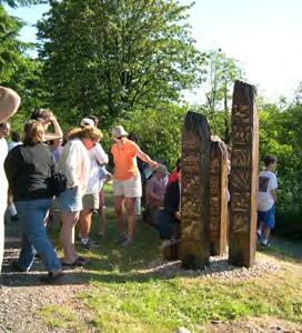
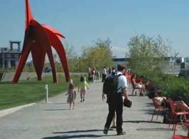
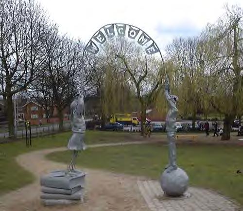
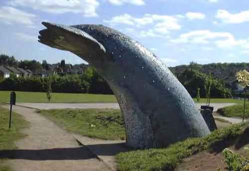
28 SPARTANBURG, SOUTH CAROLINA Public Art Explore opportunities to include public art within the overall design of the trail system. Below are examples of public art along trails. According to American Trails, Art is one of the best ways to strengthen the connection between people and trails. Across America and elsewhere, artists are employing a remarkably wide range of creative strategies to support all phases of trail activities, from design and development to stewardship and interpretation. In particular, art can be an effective tool for telling a trail s story compellingly and memorably. Example art programs for trails can be found at: Chapter Ten: Design Guidelines


29 BICYCLE AND PEDESTRIAN MASTER PLAN Chapter Ten: Design Guidelines 261
30 SPARTANBURG, SOUTH CAROLINA 262 Chapter Ten: Design Guidelines
Understanding user expectations And planning for long term sustainability 1
 Understanding user expectations And planning for long term sustainability 1 What is a natural surface trail? It can be as simple has a mineral soil, mulched or graveled pathway, or as developed as elevated
Appendix 3. Greenway Design Standards. The Whitemarsh Township Greenway Plan
 Appendix 3 Greenway Design Standards This chapter discusses two design standards for the greenway types discussed above. First, trail design standards are presented together with trailhead facilities and
Lake Apopka Trail Loop Design Guidelines
 November 2002 Prepared for 14908 Tilden Road Winter Garden, FL 34787 Prepared by 140 North Orlando Avenue Suite 295 Winter Park, FL 32789 November, 2002 I. INTRODUCTION...1 II. DESIGN GUIDELINES FOR TRAILS...3
MORGAN CREEK GREENWAY Final Report APPENDICES
 APPENDICES MORGAN CREEK GREENWAY Appendix A Photos of Existing Conditions in Trail Corridor Photos of existing conditions Main trail corridor - February 2009 Photos of existing conditions south bank Morgan
City of Durango 5.8 FUNDING TRAILS DEVELOPMENT
 5.8 FUNDING TRAILS DEVELOPMENT The City has been successful in establishing dedicated local funding sources as well as applying for grants to develop the City s trail system, having received nearly $2.4
FEASIBILITY CRITERIA
 This chapter describes the methodology and criteria used to evaluate the feasibility of developing trails throughout the study areas. Land availability, habitat sensitivity, roadway crossings and on-street
The Baker/Carver Regional Trail is intended to
 Section V Design Guidance The Baker/Carver Regional Trail is intended to safely accommodate 183,000 annual visits, an array of non-motorized uses, a variety of skill levels, and persons with special needs.
Port Gamble Shoreline Area Conceptual Trail Proposal
 The North Kitsap Trails Association is pleased to be a partner to the Kitsap Forest and Bay Project and assist Kitsap County, Forterra, Olympic Property Group, Great Peninsula Conservancy and the Port
Blue River Trail Master Plan JSA to Town Hall June 2004
 Blue River Trail Master Plan JSA to Town Hall June 2004 Prepared for: Silverthorne Town Council Silverthorne SPORT Committee Department of Recreation and Culture Silverthorne Public Works Silverthorne
CHAPTER III: TRAIL DESIGN STANDARDS, SPECIFICATIONS & PERMITS
 CHAPTER III Trail Design Standards, Specifications & Permits This chapter discusses trail standards, preferred surface types for different activities, permits, and other requirements one must consider
K SIGNAGE & TRAFFIC CONTROL. Table of Contents
 Table of Contents K1. ACCOMMODATION OF TRAFFIC... 1 K2. MINIMUM CONSTRUCTION SIGNING... 1 K3. SUBDIVISION SIGNS... 2 K4. TRAFFIC CONTROL DEVICES... 2 K4.1 Traffic Signs Regulations... 2 K4.2 Materials...
DATE: 23 March, 2011 TO: Communities FROM: BlazeSports America. RE: Accessible Trails Checklist 1
 M E M O R A N D U M DATE: 23 March, 2011 TO: Communities FROM: BlazeSports America RE: Accessible Trails Checklist 1 The purpose of the Accessible Trails Checklist (below) is to help the community review
METROPOLITAN COUNCIL 390 North Robert Street, St. Paul, MN Phone (651) TDD (651)
 TDD (651)") METROPOLITAN COUNCIL 390 North Robert Street, St. Paul, MN 55101 Phone (651) 602 1000 TDD (651) 291 0904 DATE: June 19, 2007 TO: Metropolitan Parks and Open Space Commission FROM: Jan Youngquist, Senior
METROPOLITAN COUNCIL 390 North Robert Street, St. Paul, MN 55101 Phone (651) 602 1000 TDD (651) 291 0904 DATE: June 19, 2007 TO: Metropolitan Parks and Open Space Commission FROM: Jan Youngquist, Senior
Permeable RECREATIONAL TRAILS
 SMART EARTH SOLUTIONS Permeable RECREATIONAL TRAILS GEOWEB GEOPAVE GEOTERRA Innovative Solutions for Designing & Building Trails. Trail Surface Stabilization The key to planning and building trails into
Assessing Your Trails, Keeping Them Safe and Enjoyable
 Jon Wood, PLA, ASLA Associate Vice President Stewart Bert Lynn, PLA, ASLA, LEED AP Project Manager Mecklenburg County Asset and Facility Management Assessing Your Trails, Keeping Them Safe and Enjoyable
Outdoor Developed Areas
 The United States Access Board is an independent federal agency that promotes equality for people with disabilities through leadership in accessible design and the development of accessibility guidelines
What s covered. What s not covered. Options for those not covered. ABA Coverage
 The United States Access Board is an independent federal agency that promotes equality for people with disabilities through leadership in accessible design and the development of accessibility guidelines
Railroad Safety Trail
 2.1 INTRODUCTION AND PROJECT SETTING 2.1 Introduction & Project Setting Introduction This study is the result of a directed effort on the part of the City of San Luis Obispo to carry out previously established
Blueways: Rivers, lakes, or streams with public access for recreation that includes fishing, nature observation, and opportunities for boating.
 Parks, Open Space and Trails PRINCE WILLIAM COUNTY 2008 COMPREHENSIVE PLAN TRAILS PLAN CONTENTS The components of the trails plan are: Intent Definitions Goals, Policies, and Action Strategies Trails Map
National Recreation Trail Application for Designation
 National Recreation Trail Application for Designation Introduction Thank you for your interest in the National Recreation Trail (NRT) program. Completed NRT application packages must be submitted by December
Citrus Heights Creek Corridor Trail Project Trail Advisory Group Field Trip #2 September 11, :00 11:00 am Trellis Hall, Citrus Heights
 September 11, 2013 9:00 11:00 am Trellis Hall, Citrus Heights Project Overview The City of Citrus Heights is studying the feasibility of establishing a multi use trail system within the City s 26 miles
Buena Vista Community Trails Plan
 Buena Vista Community Trails Plan Prepared by the Buena Vista Trails Advisory Board For the Buena Vista Board of Trustees May 2008 Table of Contents Acknowledgments 1 Introduction 1 I. Trails and the Town
National Recreation Trail Update Form
 National Recreation Trail Update Form Introduction Thank you for taking the time to complete this form. Your assistance will help ensure that the National Recreation Trail (NRT) database is complete and
Trail Feasibility Study
 VOLUSIA COUNTY MPO CITY OF NEW SMYRNA BEACH FINAL REPORT JUNE 30, 2009 Trail Feasibility Study What s inside? 1 Introduction 2 Project Purpose & Scope 3 Physical Inventory & Assessment of Right-of- Way
Chapter 6: POLICY AND PROCEDURE RECOMMENDATIONS
 Chapter 6 POLICY AND PROCEDURE RECOMMENDATIONS FOR SRRA Below are seven policy elements that should be considered for adoption by the Southwest Regional Recreation Authority of Virginia: 1. Develop strategies
River Parks Trail: Tulsa, Oklahoma
 River Parks Trail: Tulsa, Oklahoma Purpose: The purpose of the River Parks Trail is to maintain, preserve, develop, and promote the Arkansas River for the economic and cultural benefit of the community.
Becker County Trail Routing Feasibility Study
 2016 Becker County Trail Routing Feasibility Study CONNECTING DETROIT MOUNTAIN AND MOUNTAIN VIEW RECREATIONAL AREA TO THE HEARTLAND TRAIL BECKER COUNTY ULTEIG ENGINEERS Contents Acknowledgements...2 INTRODUCTION...3
2. Goals and Policies. The following are the adopted Parks and Trails Goals for Stillwater Township:
 D. PARKS AND TRAILS 1. Introduction Stillwater Township s population is relatively low, with most residents living on rural residences on large lots. The need for active park space has been minimal in
Aspen Skiing Company Policy for Use of Other Power-Driven Mobility Devices And Service Animals
 Aspen Skiing Company Policy for Use of Other Power-Driven Mobility Devices And Service Animals Introduction New rules under the Americans with Disabilities Act (ADA), Titles II and III, went into effect
APPENDIX D: SUSTAINABLE TRAIL DESIGN. APPENDICES Town of Chili Parks and Recreation Master Plan Update
 APPENDIX D: SUSTAINABLE TRAIL DESIGN APPENDICES Town of Chili Parks and Recreation Master Plan Update Sustainable Trail Construction Sustainable trails are defined by the US Forest Service as trails having
Design Considerations For Accessible Parks & Trails
 Design Considerations For Accessible Parks & Trails Measuring Up: Campbell River 2008 Dave Calver Consulting City of Campbell River Legacies Now: Measuring Up Design Guidelines Design Considerations for
Snowmobile GUIDELINES FOR TRAIL SIGNING
 STATE OF NEW HAMPSHIRE BUREAU OF TRAILS Snowmobile GUIDELINES FOR TRAIL SIGNING TRAIL FUNDED BY REGISTRATION FEES Table of Contents Introduction... Some Things to Take Into Consideration... BOT Provided
Longmont to Boulder Regional Trail Jay Road Connection DRAFT FINAL REPORT
 Longmont to Boulder Regional Trail Jay Road Connection DRAFT FINAL REPORT December 2018 Project Summary Boulder County, Colorado, in partnership with the City of Boulder, is evaluating options for multi-use
Jefferson County Non-Motorized Transportation and Recreational Trails Plan 2010
 Chapter 8: Goals and objectives Plan Update: The following update presents general principles, goals, and objectives related to non-motorized transportation facilities as a component of the overall transportation
Georgetown-Lewes Rail/Trail Study. Rail/Trail Study: Cool Spring to Cape Henlopen State Park New Road Extension (House Resolution No.
 Georgetown-Lewes Rail/Trail Study Rail/Trail Study: Cool Spring to Cape Henlopen State Park New Road Extension (House Resolution No. 47) August 22, 2011 Presentation Outline Background Benefits Statewide
Attachment No. 20 RRLRT No. 1. Committee. Busway Grade Crossings STATUS/DATE OF ACTION
 Attachment No. 20 RRLRT No. 1 TECHNICAL COMMITTEE: Railroad / Light Rail Transit Technical Committee TOPIC: Busway Grade Crossings STATUS/DATE OF ACTION RRLRT TC Draft: 06/23/2011 RRLRT TC Approval: 06/27/2014
Proposed Architectural Barriers Act Accessibility Guidelines for Outdoor Developed Areas
 Proposed Architectural Barriers Act Accessibility Guidelines for Outdoor Developed Areas Outdoor Developed Areas Homepage Guidelines and Standards Published in the Federal Register on June 20, 2007. PDF
Peter Axelson. Beneficial Designs, Inc. Minden, NV
 Peter Axelson Beneficial Designs, Inc. Minden, NV Arroya Sit Ski Mono Ski Dynamic Seating Spring Assist Cross Country Ski Hand Bike Adaptive Canoe Seating Available from Chosen Valley Canoe Accessories
TRAILS INTERSECTION SIGNS
 TRAILS INTERSECTION SIGNS Intersection signs shall be placed at all trail intersections and located a minimum of 3 from the edge of trail. The top of the post shall pitch away from the sign and trail.
University Region Non-Motorized Plan 2015
 Non-Motorized Transportation Non-motorized facilities are important components to the transportation system. They provide an environmentally-friendly, low-cost mode of travel. Some of the facilities can
Non-Motorized Transportation
 Non-Motorized Transportation Non-motorized facilities are important components to the transportation system. They provide an environmentally-friendly, low-cost mode of travel. Some of the facilities can
Lafourche Parish Government REQUEST FOR QUALIFICATIONS. Landscape Architectural Services
 Lafourche Parish Government REQUEST FOR QUALIFICATIONS Landscape Architectural Services Bayou Lafourche Parish Multi-Use Path Feasibility Study Phase 1 And Bayou Lafourche Parish Multi-Use Path Feasibility
INTRODUCTION. Mailing address: Burke County Community Development Attn: Tim Johnson P. O. Box 219 Morganton, NC
 REQUEST FOR QUALIFICATIONS: PROFESSIONAL, EXPERIENCED TRAIL BUILDERS FOR THE CONSTRUCTION OF THE FONTA FLORA STATE TRAIL LAKE JAMES SECTION BURKE COUNTY COMMUNITY DEVELOPMENT INTRODUCTION Burke County
DRAFT FINAL ACCESSIBILITY GUIDELINES FOR OUTDOOR DEVELOPED AREAS
 Date: October 19, 2009 DRAFT FINAL ACCESSIBILITY GUIDELINES FOR OUTDOOR DEVELOPED AREAS Introduction Background Whom Guidelines Apply To How to Submit Comments Contact for Further Information General Issues:
DRAFT. Dorabelle Campground Rehabilitation
 DRAFT Dorabelle Campground Rehabilitation September 2012 1.1 REGIONAL SETTING AND PROJECT LOCATION The Dorabelle Campground is located on the western shore of Shaver Lake in Fresno County, California (Section
Regional Wayfinding Sign Strategy Thurston County Trails 2017
 Regional Wayfinding Sign Strategy Thurston County Trails 2017 Partners: Members and partnering organizations of the Thurston Thrives Community Design Action Team City of Lacey, City of Olympia, City of
Section 61 Recreational Vehicle Park / Campground (Bylaw No. 2012/10)
") Part 7 General Regulations Section 61 Recreational Vehicle Park / Campground (Bylaw No. 2012/10) 61.1 A comprehensive site plan shall be provided to the satisfaction of the Development Authority that shows
Part 7 General Regulations Section 61 Recreational Vehicle Park / Campground (Bylaw No. 2012/10) 61.1 A comprehensive site plan shall be provided to the satisfaction of the Development Authority that shows
FINCH HYDRO CORRIDOR TRAIL PROJECT
 FINCH HYDRO CORRIDOR TRAIL PROJECT Pharmacy Avenue to Birchmount Road January 29 th, 2018 L Amoreaux Community Centre (2000 McNicoll Avenue) 1 Purpose of Drop In Event The purpose of today s drop-in event
SELF RE-ERECTING MARKER POSTS
 ONE OF A KIND TECHNOLOGY FOR OUR TIMES MULTI APPLICATIONS SELF RE-ERECTING MARKER POSTS TEMPORARY OR PERMANENT BICYCLE LANES CROSSWALKS CHANALIZATION BRIDGES CITY US REFLECTOR WORK ZONES ALL-ROUND RUGGEDNESS
AGENDA ITEM 5 D WAKULLA ENVIRONMENTAL INSTITUTE (WEI) TRAIL FEASIBILITY STUDY
 TRAIL FEASIBILITY STUDY") March 19, 2018 AGENDA ITEM 5 D WAKULLA ENVIRONMENTAL INSTITUTE (WEI) TRAIL FEASIBILITY STUDY TYPE OF ITEM: Action STATEMENT OF ISSUE The Wakulla Environmental Institute (WEI) Trail is one of several trails
March 19, 2018 AGENDA ITEM 5 D WAKULLA ENVIRONMENTAL INSTITUTE (WEI) TRAIL FEASIBILITY STUDY TYPE OF ITEM: Action STATEMENT OF ISSUE The Wakulla Environmental Institute (WEI) Trail is one of several trails
Location: Cariboo, Williams Lake, Cariboo Chilcotin Coast - Recreation : Site (Heritage Discovery Circle Route)
") Mt Robson Visitors Centre Information Date of Audit: 2016-07-28 Park Name: Dugan Lake Key Features: View_Point,Camping,Picnic_Site,Playground,Fishing Location: Cariboo, Williams Lake, Cariboo Chilcotin
Mt Robson Visitors Centre Information Date of Audit: 2016-07-28 Park Name: Dugan Lake Key Features: View_Point,Camping,Picnic_Site,Playground,Fishing Location: Cariboo, Williams Lake, Cariboo Chilcotin
4. Improvement Plan Elements
 4. Improvement Plan Elements Detailed description of all elements Leigh Creekside Park Improvement Plan Preliminary Conceptual Time Zone Layout Caveat: in the following plans and descriptions, specific
If we make accessibility an up-front consideration that guides our planning & design efforts.
 Cindy Burkhour, MA, CTRS, CPRP AccessRecreationGroup@juno.com 616-560-2378 Accessibility invites more trail users & their $$ to your community! If we make accessibility an up-front consideration that guides
Draft proposed amendments. Chapter Terminology
 Draft proposed amendments Chapter 20.100 - Terminology 20.100.010 - General Terms The words and terms expressly defined in this chapter have the specific meanings assigned, unless the context expressly
FINAL. Bicycle/Pedestrian Feasibility Study City of DeBary Dirksen Drive Trail. Prepared For: Volusia County MPO
 City of DeBary Dirksen Drive Trail FINAL Prepared By: Reynolds, Smith and Hills, Inc. Prepared For: Volusia County MPO September 2007 Table of Contents INTRODUCTION...1 PROJECT PURPOSE AND SCOPE...2 PHYSICAL
3. COLTA / HUGA CONNECTIONS - PRELIMINARY
 9 3. COLTA / HUGA CONNECTIONS - PRELIMINARY 3.1 COLTA The Chain of Lakes Trail Association (COLTA) trail, formerly identified as the Chester Spur Line, was completed and opened for use in June 2011. The
No 30 x 48 space is provided for a wheelchair under the picnic table.
 ITEM: LLOYD PARK PICNIC TABLE ADA GUIDELINE: 305, 902.2 No 30 x 48 space is provided for a wheelchair under the picnic table. Remove one of the picnic table arms. Photo of Picnic Table on the bluff PARK:
COMMUNITY MEETING NOVEMBER 1, Wheaton Regional Park Pine Lake Trail
 COMMUNITY MEETING NOVEMBER 1, 2012 MEETING AGENDA I. Introduction of Project Team II. Trail Renovation Process III. Wheaton Regional Park IV. Pine Lake Trail Renovation Project V. Comments and Questions
Provincial Railway Technical Standards
 GENERAL: INDEX: The standards and requirements listed in this document are intended for use on provincially regulated railway public grade crossings. These standards are considered the minimum requirements
Rural Rustic Road Program
 Virginia Department of Transportation s Rural Rustic Road Program Prepared by the Local Assistance Division Virginia Department of Transportation 1401 East Broad Street Richmond, Virginia 23219 Michael
Mt. Hood National Forest
 United States Department of Agriculture Forest Service Mt. Hood National Forest Zigzag Ranger District 70220 E. Highway 26 Zigzag, OR 97049 503-622-3191 Fax: 503-622-5622 File Code: 1950-1 Date: June 29,
Rule Governing the Designation and Establishment of All-Terrain Vehicle Use Trails on State Land
 Rule Governing the Designation and Establishment of All-Terrain Vehicle Use Trails on State Land 1.0 Authority 1.1 This rule is promulgated pursuant to 23 V.S.A. 3506. Section 3506 (b)(4) states that an
Section 3-04 Cross Sectional Elements TABLE OF CONTENTS. INTRODUCTION...3 General...3 Exhibit 1-Cross-Sectional Elements...3
 Section 3-04 Cross Sectional Elements TABLE OF CONTENTS INTRODUCTION...3 General...3 Exhibit 1-Cross-Sectional Elements...3 CROSS-SECTIONAL ELEMENTS...3 Traveled Way...3 Shoulder...3 Surfacing Taper...3
Sandbag Barrier. Suitable Applications Sandbag barriers may be suitable: As a linear sediment control measure:
 Categories EC Erosion Control SE Sediment Control TC Tracking Control WE Wind Erosion Control Non-Stormwater NS Management Control Waste Management and WM Materials Pollution Control Legend: Primary Category
esigning Camp and Picnic Units
 Chapter D esigning Camp and Picnic Units Camp units are designed for overnight use and may include a parking pad. Picnic units generally are for day use only. Equestrian camp and picnic units do not have
Procedure for the Use of Power-Driven Mobility Devices on Mass Audubon Sanctuaries 1 September 17, 2012
 Procedure for the Use of Power-Driven Mobility Devices on Mass Audubon Sanctuaries 1 September 17, 2012 Background As part of Mass Audubon s mission to preserve the nature of Massachusetts for people and
APPENDIX F List of Commitments
 APPENDIX F List of Commitments s Table F.1 Standard Mitigation Measures Mitigation Measure MnDOT Specification Number Status Update Description Status Update Utilities Provide early notice to utility operators
Welcome to the future of Terwillegar Park a Unique Natural Park
 Welcome to the future of Terwillegar Park a Unique Natural Park 1 Introduction The Terwillegar Park Concept Plan study will develop an overall concept plan, management objectives and development guidelines
ATTACHMENT B. Page 1 of 49
 Page 1 of 49 Page 2 of 49 Page 3 of 49 Page 4 of 49 Page 5 of 49 Page 6 of 49 Page 7 of 49 Page 8 of 49 Page 9 of 49 Page 10 of 49 Page 11 of 49 Page 12 of 49 Page 13 of 49 MA-012-16011742 Attachment A
Auburn Trail / Ontario Pathways Trail Connector Feasibility Study Public Information Meeting Wednesday, August 22, 2012
 Auburn Trail / Ontario Pathways Trail Connector Feasibility Study Public Information Meeting Wednesday, August 22, 2012 Purpose of Feasibility Study Purpose Evaluate the feasibility of constructing a multiuse
Welcome to the Cross County Trail Public Input Session!
 Welcome to the Cross County Trail Public Input Session! Please sign in on the table below! What are we doing here? Camden County has proposed a bicycle and pedestrian trail spanning across the entire county.
Uniform Interjurisdictional Trail Design, Use, and Management Guidelines
 Uniform Interjurisdictional Trail Design, Use, and Management Guidelines In Fulfillment of County General Plan Policy PR-TS(i) 6A) Santa Clara County Interjurisdictional Trails Committee A Program of the
WASHINGTON STATE PARKS AND RECREATION COMMISSION POLICY/PROCEDURE
 WASHINGTON STATE PARKS AND RECREATION COMMISSION POLICY/PROCEDURE 65-13-1 Use of Other Power-Driven Mobility Devices by Persons with Mobility Disabilities at State Park Facilities See Also: 28 CFR 35 Title
City of Redding Airports
 City of Redding Airports Benton Airpark Redding Municipal Airport DEVELOPMENT AND USE GUIDELINES FOR GENERAL AVIATION HANGARS April 7, 2009 PREFACE The City of Redding, as owner of federally obligated
Appendix A Appendix A (Project Specifications) Auk Auk / Black Diamond (Trail 44) Reroute
 Auk Auk / Black Diamond (Trail 44) Reroute") Appendix A (Project Specifications) Auk Auk / Black Diamond (Trail 44) Reroute I. Proposed Action: This project proposes to reroute approximately 1,800 feet of a 50 inch wide trail, off of private property
Appendix A (Project Specifications) Auk Auk / Black Diamond (Trail 44) Reroute I. Proposed Action: This project proposes to reroute approximately 1,800 feet of a 50 inch wide trail, off of private property
ARTICLE 7 MOBILE HOME AND RECREATIONAL VEHICLE PARKS AND CAMPGROUNDS
 ARTICLE 7 MOBILE HOME AND RECREATIONAL VEHICLE PARKS AND CAMPGROUNDS Section 701. APPLICABILITY Where a municipality has no subdivision or land development ordinance the provisions of this article shall
The following criteria shall be applied within the boundaries of the AO District:
 Sec. 419 (a) Purpose AIRPORT OVERLAY DISTRICT (AO) The purpose of the Airport Overlay District is to regulate and restrict the height of structures, objects, or natural growth, regulate the locations of
Permit Application Requirements For Temporary Tents, and Membrane Structures
 CTY OF PAM DESERT Building & Safety Department Permit Application Requirements For Temporary Tents, and Membrane Structures F O R M A T O A B U E T Revised 1-30-14 73510 Fred Waring Drive Palm Desert,
Lake Myra County Park. Wake County, North Carolina Community Forum #2 June 12, 2008
 Lake Myra County Park Wake County, North Carolina Community Forum #2 June 12, 2008 Welcome and Introduction Meeting Agenda Welcome Introductions of Project Team Master Plan Process Community Forum #1 Updates
CHAPTER 4 -- THE LAND USE PLAN: DESCRIPTIONS AND POLICIES FOR THIRTEEN PLANNING AREAS
 CHAPTER 4 -- THE LAND USE PLAN: DESCRIPTIONS AND POLICIES FOR THIRTEEN PLANNING AREAS NORTH CENTRAL CAC AREA LITTLE VALLEY ROAD TO JUG HANDLE CREEK PLANNING AREA This planning area includes Cleone, Noyo,
NEWBORO AND PORTLAND HARBOUR REDVELOPMENT PLANS
 INTRODUCTION The Municipal docks in both Newboro and Portland were transferred to the Township of Rideau Lakes by Parks Canada in 2002. Little has been done to improve the docks physical condition or role
TRAFFIC CONTROL DEVICES MANUAL FOR WORK ZONES
 TRAFFIC CONTROL DEVICES MANUAL FOR WORK ZONES SUMMARY Work zone activities often create conditions on the travelled way that are hazardous particularly at night when the ability of motorists to see is
GUIDELINES FOR SNOWMOBILE TRAIL SIGNING & PLACEMENT
 GUIDELINES FOR SNOWMOBILE TRAIL SIGNING & PLACEMENT Vermont Association of Snow Travelers 26 VAST Lane Barre, VT 05641 802-229-0005 www.vtvast.org Revised 4/12 TABLE OF CONTENTS 1.0 INTRODUCTION... 1 2.0
ROAD AND TRAIL PROJECT APPROVAL
 ROAD AND TRAIL PROJECT APPROVAL www.marincountyparks.org Marin County Parks, 3501 Civic Center Dr, Suite 260, San Rafael, CA 94903 DATE: July 12, 2017 PRESERVE: Gary Giacomini Open Space Preserve PROJECT:
Flow Stand Up Paddle Board Parkway Plan Analysis
 Regional Parks Department Jeffrey R. Leatherman, Director County of Sacramento Divisions Administration Golf Leisure Services Maintenance Rangers Therapeutic Recreation Services Flow Stand Up Paddle Board
Freestanding Litter Bins
 Freestanding Litter Bins We have a huge selection of bins for every location. If you are looking for bins for outdoor use in Ireland we would recommend the Heavy Duty 100L Litter Bin. This bin has been
Building Permit Application
 Building Permit Application Co-Owner Name Lot # Address City State Zip Phone (home) (cell) Contractor (if applicable) The above named co-owner hereby makes application to Cedar Shores Campground Condominium
COASTAL CONSERVANCY. Staff Recommendation September 22, 2011 BAY AREA RIDGE TRAIL: HOOD MOUNTAIN TO HIGHWAY 12
 COASTAL CONSERVANCY Staff Recommendation September 22, 2011 BAY AREA RIDGE TRAIL: HOOD MOUNTAIN TO HIGHWAY 12 File No. 11-039-001 Project Manager: Betsy Wilson RECOMMENDED ACTION: Authorization to disburse
Members of the York Region Accessibility Advisory Committee. Accessibility Design Guidelines for York Regional Forest Trails
 Environmental Services Department Environmental Promotion and Protection Branch MEMORANDUM TO: FROM: Members of the York Region Accessibility Advisory Committee Ian Buchanan, Manager, Natural Heritage
Who is Beneficial Designs?
 Who is Beneficial Designs? Beneficial Designs works towards universal access through research, design, and education. We believe all individuals should have access to the physical, intellectual, and spiritual
Chapter 4.0 Alternatives Analysis
 Chapter 4.0 Alternatives Analysis Chapter 1 accumulated the baseline of existing airport data, Chapter 2 presented the outlook for the future in terms of operational activity, Chapter 3 defined the facilities
Lake Wissota Access Locations within the LaFayette Township. By Chad Martin
 Lake Wissota Access Locations within the LaFayette Township By Chad Martin Anson/ Wissota Access Point # 1 Road: 195 th St. Associated Fire Numbers: 13294 Defining Characteristics: Forested from road
Trail # NW Tuesday, June DESIGN. Provide an Review the Provide an. Project Goals: System system. wayfinding
 I. Welcome / Introductions Bethany Creek Trail #2 Segment 3 Neighborhood Meeting #1 Bethany Presbyterian Church 15505 NW Springville Road, Portland, OR 97229 Tuesday, June 26, 2018 @ 6:00PM Meeting Minutes
Great Pond Mountain Conservation Trust Request for Bids Wildlands Hillside Trail Relocation and Restoration Project
 Great Pond Mountain Conservation Trust Request for Bids Wildlands Hillside Trail Relocation and Restoration Project Project Description: Great Pond Mountain Conservation Trust (GPMCT), a nonprofit land
Business Item No
 Metropolitan Parks and Open Space Commission Meeting date: February 6, 2018 For the Community Development Committee meeting of February 20, 2018 For the Metropolitan Council meeting of February 28, 2018
Tallahassee-St. Marks Historic Railroad Trail
 Revitalizing a Historic Trail Designated as a National Recreation Trail, the 16-mile Tallahassee-St. Marks Historic Railroad Trail has been enjoyed by countless bicyclists, runners, and outdoor enthusiasts
Guidelines for Snowmobile Trail Signing and Placement STOP SLOW
 Guidelines for Snowmobile Trail Signing and Placement STOP SLOW Table of Contents 1.0 Introduction... 2 6.0 Examples of Sign Use...7 2.0 Purpose of this Document... 2 3.0 Trail Signing Guidelines... 2
Waukee Trailhead Public Art and Amenities Project
 Waukee - Trailhead Public Art and Amenities Project Sponsor Waukee Project Title Waukee Trailhead Public Art and Amenities Project Termini Description ( i.e. Park Avenue to 19th Street) NE Intersection
Little River Trail Feasibility Study
 Final April, 2014 Prepared for the State Coastal Conservancy By the Natural Resources Services Division of Redwood Community Action Agency Table of Contents Executive Summary... 1 1. Project Purpose and
DD FORM 3009, FEB 2016 REPLACES DA FORM 1247, WHICH IS OBSOLETE. Page 1 of 6 Pages Adobe Professional X
 ROUTE CLASSIFICATION For use of this form, see ATP 3-34.81/MCWP 3-17.4; the proponent agency is TRADOC. SECTION I 1. SERIAL NUMBER 2. TO 3. FOR INFORMATION 4. DATE/TIME GROUP 5. NUMBER OF SHEETS OR ENCLOSURES