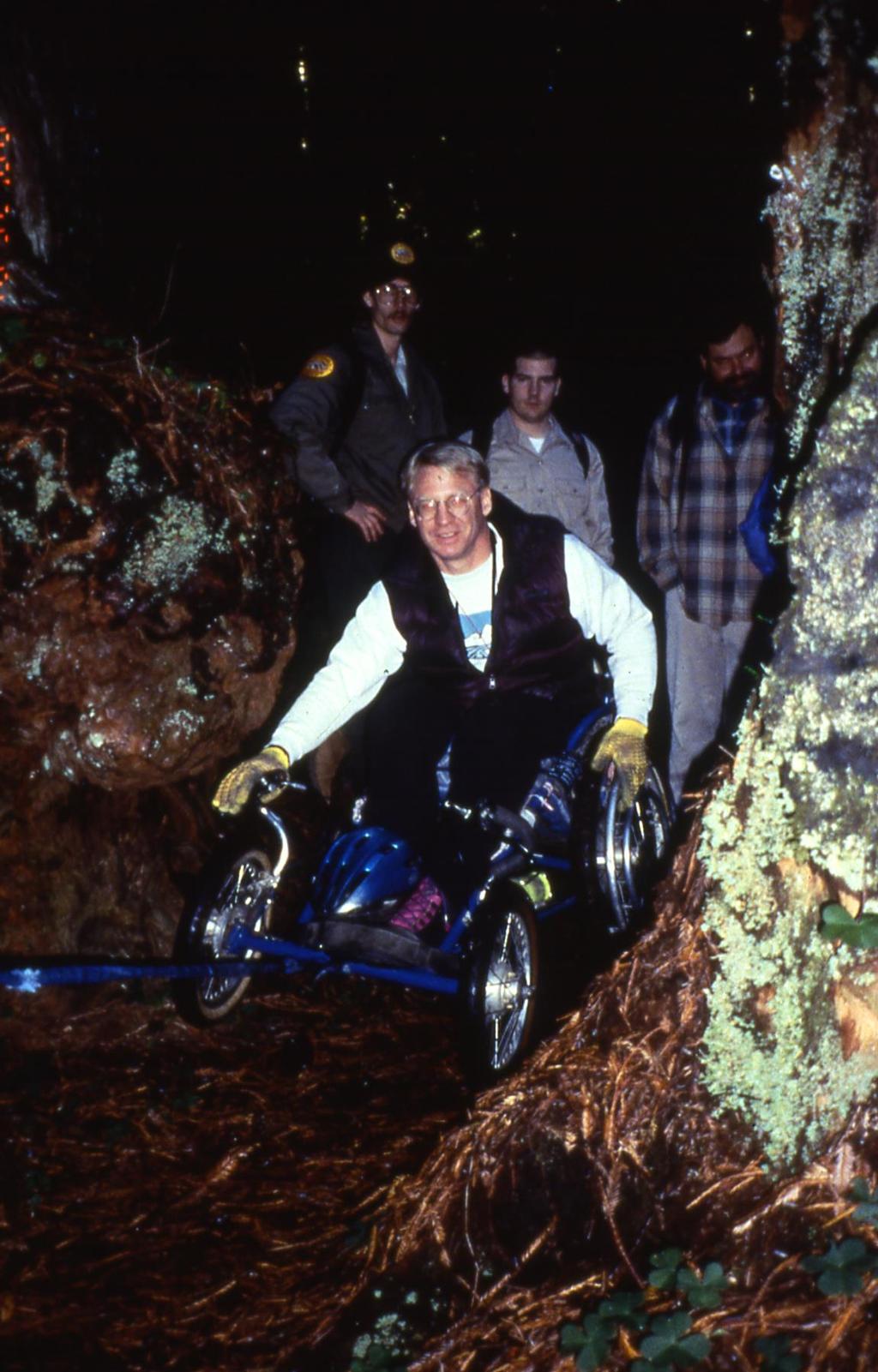
If we make accessibility an up-front consideration that guides our planning & design efforts.
|
|
|
- David McBride
- 5 years ago
- Views:
Transcription
1 Cindy Burkhour, MA, CTRS, CPRP Accessibility invites more trail users & their $$ to your community! If we make accessibility an up-front consideration that guides our planning & design efforts.
2 TWENTY PERCENT OF AMERICANS HAVE SOME TYPE OF DISABILITY CHARACTERISTIC THAT MAY AFFECT THEIR ABILITY TO USE YOUR LAND AND WATER TRAILS... IF YOU DON'T MAKE YOUR TRAILS AND THE SUPPORTING AMENITIES ACCESSIBLE YOU NOT ONLY MISS SERVING THAT 20%, BUT YOU MISS SERVING THEIR FRIENDS AND FAMILIES AS WELL, AND THAT TRANSLATES INTO 35% - 50% OF YOUR POTENTIAL VISITORS WON'T COME TO HIKE OR PADDLE OR SPEND MONEY IN YOUR COMMUNITY... SO IMPROVING ACCESSIBILITY IS GOOD FOR BUSINESS $$$!
3 COMPLYING WITH THE MINIMUM ADA ACCESSIBILITY DESIGN GUIDELINES IS THE LAW, BUT UNDERSTAND. It s the worst you are allowed to do by law for accessibility It makes your design as hard to use as legally allowable by law Going above and beyond these minimums to embrace inclusive universally accessible designs is allowed and encouraged!

4 ALWAYS STRIVE FOR INCLUSIVE UNIVERSALLY ACCESSIBLE DESIGN FOR ALL TYPES OF TRAILS Easier to use by everyone together All people of all abilities All ages All skills Independent use Safe Intuitive
 Firm and stable")

5 Accessible route to the launch from parking Gentle slopes (under5%) Firm and stable seasonal and permanent surface GOOD INCLUSIVE UNIVERSAL DESIGN WATER TRAIL EXAMPLES Greilickville Midland

6 Good clear space for moving around on the dock and at transfer boarding bench

7 Frequently Asked Questions What is a Blueway? A blueway is a water path or trail that is developed with launch points, camping locations and points of interest for canoeists and kayakers. SIGNED IDENTIFIED ON MAPS & WEBSITES Where can I rent a canoe or kayak in St. Clair County? The St. Clair City Marina, located at 902 S. 2 nd Street, St. Clair, MI Rentals: Canoes/kayaks $10 per hour, $35 4 hours, $60 8 hours. Where are the Wheelchair accessible launches? There are four at this time. River Front Park off North River Road in Fort Gratiot Township, the City of St. Clair Marina, and the Marysville Boat Launch north of the water treatment plant, all offer ADA accessible kayak launches. The newest one is at Baker's Field Park in Port Huron Township.

8 INCLUSIVE UNIVERSALLY ACCESSIBLE LAUNCH SYSTEM EZ-Launch by EZ-Dock is the only inclusive universal design on the market to date and is a good example that goes above and beyond minimum ADA design guidelines

9 ACCESS TO TRAILS WHY SHOULD WE DO IT?

10 ANY QUESTIONS ABOUT WHY?

11 SO HOW DO WE CREATE INCLUSIVE AND UNIVERSALLY ACCESSIBLE TRAILS for everyone?
12 WE CREATE ACCESSIBLE AND USER FRIENDLY DESIGNATED TRAILHEADS designated accessible parking accessible routes to amenities & trails information kiosks identifying trail accessibility features on signs & trail maps accessible single user restrooms water hydrants that are one hand operable with ample clear space & on an accessible route


13
14 WE DESIGN TRAILS WITH INCLUSIVE & UNIVERSALLY ACCESSIBLE TREAD WIDTHS Wide enough for side by side walking or passing so no one has to step off the trail into the bush to pass by Wide enough so encroaching vegetation doesn t grow into/over the trail tread between seasonal maintenance efforts Wide enough to accommodate trail tread maintenance equipment Wide enough so it s easy to turn around pushing a stroller or using a wheelchair

15 CLEAR TREAD WIDTH
16 WE MAKE TRAIL SURFACES UNIVERSALLY ACCESSIBLE by making them firm and stable in all kinds of weather and over the course of the season Stabilized natural soils Crushed aggregate Board walk Asphalt Concrete EZ-Trail floating trail We can use surface treatments to direct human behavior and to better protect sensitive environments

17


18 WELL DONE SURFACES

19 PROTECT USERS FROM PROTRUDING OBJECTS


20 REMOVE TRAIL TREAD OBSTACLES

21 REDUCE SLOPES Running slope less than 5% when ever possible Cross slope less than 2% when ever possible
22 PROVIDE THOUGHTFULLY POSITIONED RESTING INTERVALS Level and larger than the minimum size allowed 60 X 60 Located at the top and bottom of all steep sections and more often on longer sloped runs Positioned thoughtfully at beautiful turn outs and lovely viewing spots Add a bench for companions to sit and rest as well Located off the main trail tread so others may pass by


23

24 PROVIDE EDGE PROTECTION WHEN NEEDED Use natural materials when possible Use to direct human behavior to protect sensitive environments

25 ACCESSIBILITY INFORMATION ON SIGNS AND MAPS Length of the trail or trail segment Surface type Typical and minimum tread width Typical and maximum running slope Typical and maximum cross slope Benches & resting areas

26 TRAILS IN REVIEW Signed with access information firm and stable surface two people wide free of encroaching vegetation, tread obstacles, and openings Resting spaces Reasonable slopes
27 INCLUSIVE UNIVERSALLY ACCESSIBLE SITE DESIGN AND AMENITIES All that are easier to use by everyone together!

28 SITE DESIGN & AMENITIES Accessible Restrooms Including a single-user/unisex family friendly design (so opposite sex care givers can assist & parents of little ones can too!)
, & may have a water bottle filler tap as")
29 SITE DESIGN & AMENITIES Accessible potable water located on an accessible route with accessible operating mechanism that is easily operated with one hand (and that doesn t require tight pinch grasp or twist motions or two hands to work), & may have a water bottle filler tap as well!
 located on accessible route from the water landing or trail head and from the parking")
30 SITE DESIGN & AMENITIES universally accessible picnic tables (like the Spyder table by Wabash Valley) located on accessible route from the water landing or trail head and from the parking lot

31 SITE DESIGN & AMENITIES Accessible parking for cars (& boat trailers at water trail launches) located nearest the route to the waters edge or the trail head and the accessible routes to all the amenities


32 SITE DESIGN & AMENITIES ACCESSIBLE ROUTES WITH GENTLE SLOPES (AT LESS THAN 5% SLOPE) FROM PARKING TO ALL AMENITIES, TO THE TRAIL HEAD OR TO THE WATERS EDGE LAUNCH AREA
33 IN REVIEW A GOOD INCLUSIVE UNIVERSALLY ACCESSIBLE HIKING TRAILS OR WATER TRAILS INCLUDES: Accessible parking for cars (& boat trailers located nearest the route to the waters edge) and the accessible routes to all the amenities Accessible restrooms including a single-user/unisex family friendly design (so opposite sex care givers can assist & parents of little ones can too!) Accessible potable water located on an accessible route with accessible operating mechanism that is easily operated with one hand (and that doesn t require tight pinch grasp or twist motions or two hand to work), & may have a water bottle filler tap as well, universally accessible picnic tables (like the Spider table by Wabash valley) located on accessible route from the water landing or trail head and from the parking lot accessible routes with Gentle slopes (at less than 5% slope) to all amenities Universally Accessible launch system (EZ-Launch by EZ-Dock is one example that goes above and beyond min ADA design guidelines) Accessibility feature information on kiosks, trail maps, web-sites
34 MAKING IT HAPPEN Engage the community in planning, including people with disabilities Connect all trail heads, via accessible route, to community assets Be welcoming in your images and your words Host events to draw people off the trail and into town Make it easy for your citizens to enjoy your trails Create trail stewardship opportunities reward trail users with discounts or community tokens (stickers, key fobs ) reward businesses that embrace trail visitors with recognition & free media Become a trail town!
35 QUESTIONS?? Cindy Burkhour, MA, CTRS, CPRP cell:
Outdoor Developed Areas
 The United States Access Board is an independent federal agency that promotes equality for people with disabilities through leadership in accessible design and the development of accessibility guidelines
What s covered. What s not covered. Options for those not covered. ABA Coverage
 The United States Access Board is an independent federal agency that promotes equality for people with disabilities through leadership in accessible design and the development of accessibility guidelines
DATE: 23 March, 2011 TO: Communities FROM: BlazeSports America. RE: Accessible Trails Checklist 1
 M E M O R A N D U M DATE: 23 March, 2011 TO: Communities FROM: BlazeSports America RE: Accessible Trails Checklist 1 The purpose of the Accessible Trails Checklist (below) is to help the community review
Location: Central Coast, Bella Coola, Cariboo Chilcotin Coast - Provincial : Campground (Discovery Coast Circle Route)
") Mt Robson Visitors Centre Information Date of Audit: 2016-08-26 Park Name: Fisheries Pool Campground Key Features: Camping,Picnic_Site,Beach,Fishing Location: Central Coast, Bella Coola, Cariboo Chilcotin
Mt Robson Visitors Centre Information Date of Audit: 2016-08-26 Park Name: Fisheries Pool Campground Key Features: Camping,Picnic_Site,Beach,Fishing Location: Central Coast, Bella Coola, Cariboo Chilcotin
Welcome to the AccessibilityOnline Webinar Series. Listening to the Webinar. Listening to the Webinar, continued
 Welcome to the AccessibilityOnline Webinar Series A collaborative program between the ADA National Network and the U.S. Access Board The Session is Scheduled to begin at 2:30pm Eastern Time We will be
Port Gamble Shoreline Area Conceptual Trail Proposal
 The North Kitsap Trails Association is pleased to be a partner to the Kitsap Forest and Bay Project and assist Kitsap County, Forterra, Olympic Property Group, Great Peninsula Conservancy and the Port
National Recreation Trail Application for Designation
 National Recreation Trail Application for Designation Introduction Thank you for your interest in the National Recreation Trail (NRT) program. Completed NRT application packages must be submitted by December
Camping (Primitive) Camping (RV) Electrical Potable Water Grill Established Fire Pit Picnic Table
 Camping (RV) Electrical Potable Water Grill Established Fire Pit Picnic Table") Alden - 9th Road River Mile 777 Map: 38.20833, -98.32031 Managing Agency: Kansas Department of Wildlife, Parks & Tourism Nearest Community: Alden, Rice County Kansas Developed Amenities Provided Parking
Alden - 9th Road River Mile 777 Map: 38.20833, -98.32031 Managing Agency: Kansas Department of Wildlife, Parks & Tourism Nearest Community: Alden, Rice County Kansas Developed Amenities Provided Parking
Forest Service Outdoor Recreation Accessibility Guidelines (FSORAG)
") United States Department of Agriculture Forest Service Outdoor Recreation Accessibility Guidelines (FSORAG) Pocket Version Forest Service National Technology & Development Program 1523 2811 MTDC Recreation
United States Department of Agriculture Forest Service Outdoor Recreation Accessibility Guidelines (FSORAG) Pocket Version Forest Service National Technology & Development Program 1523 2811 MTDC Recreation
Location: Cariboo, Williams Lake, Cariboo Chilcotin Coast - Recreation : Site (Heritage Discovery Circle Route)
") Mt Robson Visitors Centre Information Date of Audit: 2016-07-28 Park Name: Dugan Lake Key Features: View_Point,Camping,Picnic_Site,Playground,Fishing Location: Cariboo, Williams Lake, Cariboo Chilcotin
Mt Robson Visitors Centre Information Date of Audit: 2016-07-28 Park Name: Dugan Lake Key Features: View_Point,Camping,Picnic_Site,Playground,Fishing Location: Cariboo, Williams Lake, Cariboo Chilcotin
Who is Beneficial Designs?
 Who is Beneficial Designs? Beneficial Designs works towards universal access through research, design, and education. We believe all individuals should have access to the physical, intellectual, and spiritual
National Recreation Trail Update Form
 National Recreation Trail Update Form Introduction Thank you for taking the time to complete this form. Your assistance will help ensure that the National Recreation Trail (NRT) database is complete and
DRAFT FINAL ACCESSIBILITY GUIDELINES FOR OUTDOOR DEVELOPED AREAS
 Date: October 19, 2009 DRAFT FINAL ACCESSIBILITY GUIDELINES FOR OUTDOOR DEVELOPED AREAS Introduction Background Whom Guidelines Apply To How to Submit Comments Contact for Further Information General Issues:
Appendix 3. Greenway Design Standards. The Whitemarsh Township Greenway Plan
 Appendix 3 Greenway Design Standards This chapter discusses two design standards for the greenway types discussed above. First, trail design standards are presented together with trailhead facilities and
Location: Kitimat-Stikine, Terrace, Northern BC - Provincial : Park (Heritage Discovery Circle Route)
") Mt Robson Visitors Centre Information Date of Audit: 2016-08-09 Park Name: Lakelse Lake Provincial Group Camping Key Features: Camping,Picnic_Site,Beach,Trails Location: Kitimat-Stikine, Terrace, Northern
Mt Robson Visitors Centre Information Date of Audit: 2016-08-09 Park Name: Lakelse Lake Provincial Group Camping Key Features: Camping,Picnic_Site,Beach,Trails Location: Kitimat-Stikine, Terrace, Northern
Logo Department Name Agency Organization Organization Address Information 5700 North Sabino Canyon Road
 Logo Department Name Agency Organization Organization Address Information United States Forest Coronado National Forest 5700 North Sabino Canyon Road Department of Service Santa Catalina Ranger District
The Whitefish Trail
 The Trail - 2017 Trail Construction Specifications & Scope of Services The Lower Haskill section of Trail construction will take place on two different land ownerships: City of and Iron Horse. This section
How to Build Shelters Along the Appalachian National Scenic Trail to Meet Accessibility Guidelines
 ATC LMPG-Appendix I How to Build Shelters Along the Appalachian National Scenic Trail to Meet Accessibility Guidelines Simple shelter designs are very easy to make accessible it only takes a little extra
WASHINGTON STATE PARKS AND RECREATION COMMISSION POLICY/PROCEDURE
 WASHINGTON STATE PARKS AND RECREATION COMMISSION POLICY/PROCEDURE 65-13-1 Use of Other Power-Driven Mobility Devices by Persons with Mobility Disabilities at State Park Facilities See Also: 28 CFR 35 Title
Lower Eau Claire River Water Trail
 Lower Eau Claire River Water Trail The Adventure in Our Own Backyard Our Vision Our vision is for an enhancement of a Lower Eau Claire River Water Trail that Expands opportunities for safe and fun paddling
The Baker/Carver Regional Trail is intended to
 Section V Design Guidance The Baker/Carver Regional Trail is intended to safely accommodate 183,000 annual visits, an array of non-motorized uses, a variety of skill levels, and persons with special needs.
SAXON HARBOR REDEVELOPMENT SURVEY
 SAXON HARBOR REDEVELOPMENT SURVEY SEPTEMBER, 2016 1,173 RESPONSES 1 BACKGROUND 1. WHAT TYPES OF ACTIVITIES DO YOU ENGAGE IN AT SAXON HARBOR Sightseeing Swimming Picnicing Fishing Camping Photography Motorized
No 30 x 48 space is provided for a wheelchair under the picnic table.
 ITEM: LLOYD PARK PICNIC TABLE ADA GUIDELINE: 305, 902.2 No 30 x 48 space is provided for a wheelchair under the picnic table. Remove one of the picnic table arms. Photo of Picnic Table on the bluff PARK:
Picnic Units A picnic unit is a part of a picnic area
 Grab Bars Grab bars are usually provided in buildings to provide stability and allow a person to use his or her arms to assist in movement over short distances. The most common location for grab bars is
Crystal Lake Area Trails
 Lake Area Trails Welcome to the Lake area of the Big Snowy Mountains! This island mountain range in central Montana features peaks reaching to 8,600 feet and long, high ridges from which vistas of the
Design Considerations For Accessible Parks & Trails
 Design Considerations For Accessible Parks & Trails Measuring Up: Campbell River 2008 Dave Calver Consulting City of Campbell River Legacies Now: Measuring Up Design Guidelines Design Considerations for
P Parking Lot. Shiawassee River Water Trail Development Plan. Site 2 - Potential Site - Fish Lake Road. 8 Chapter X - Chapter Title
 Shiawassee iver Water Trail Development lan Site 2 - otential Site - Fish Lake oad it/grill ack estroom Launch Signage Windsock Foot ath arallel arking arking otentially Description: An off-road, unmarked
Topsham Trail Guide.
 Topsham Trail Guide A guide to the walking, hiking, biking, water and ATV trails of Topsham, Maine and surrounding towns $4.95 Developed by the www.greatertopshamtrailalliance.org The Greater Topsham Trail
City of Durango 5.8 FUNDING TRAILS DEVELOPMENT
 5.8 FUNDING TRAILS DEVELOPMENT The City has been successful in establishing dedicated local funding sources as well as applying for grants to develop the City s trail system, having received nearly $2.4
Proposed Architectural Barriers Act Accessibility Guidelines for Outdoor Developed Areas
 Proposed Architectural Barriers Act Accessibility Guidelines for Outdoor Developed Areas Outdoor Developed Areas Homepage Guidelines and Standards Published in the Federal Register on June 20, 2007. PDF
Peter Axelson. Beneficial Designs, Inc. Minden, NV
 Peter Axelson Beneficial Designs, Inc. Minden, NV Arroya Sit Ski Mono Ski Dynamic Seating Spring Assist Cross Country Ski Hand Bike Adaptive Canoe Seating Available from Chosen Valley Canoe Accessories
Chorley Park Trail Connection New Design Options. Information Booklet Prepared for June 9, 2014 Public Meeting
 Chorley Park Trail Connection New Design Options Information Booklet Prepared for June 9, 2014 Public Meeting Chorley Park Trail Booklet June 9, 2014 Page 1 of 12 Our Goals for the Chorley Park Trail Connection
Androscoggin River Trail Access Sites. North Woods. 168 miles from its source at Lake Umbagog to Merrymeeting Bay
 Androscoggin River Trail Access Sites North Woods 168 miles from its source at Lake Umbagog to Merrymeeting Bay Trail Under Construction More than 40 Public Access Sites Available Androscoggin River Watershed
APPENDIX D: SUSTAINABLE TRAIL DESIGN. APPENDICES Town of Chili Parks and Recreation Master Plan Update
 APPENDIX D: SUSTAINABLE TRAIL DESIGN APPENDICES Town of Chili Parks and Recreation Master Plan Update Sustainable Trail Construction Sustainable trails are defined by the US Forest Service as trails having
Access Statement for RHS Garden Rosemoor
 RHS Garden Rosemoor T 01805 626 810 Great Torrington, Devon EX38 8PH F 01805 624 717 This access statement does not contain personal opinions as to our suitability for those with access needs, but aims
MORGAN CREEK GREENWAY Final Report APPENDICES
 APPENDICES MORGAN CREEK GREENWAY Appendix A Photos of Existing Conditions in Trail Corridor Photos of existing conditions Main trail corridor - February 2009 Photos of existing conditions south bank Morgan
Header i
 Header i 048285014.10 Header Sub Title Body Text here. Body text here. Body text here. Section 1... 1 Executive Summary... 1 Opportunities and Constraints... 3 Overall Opportunities and Constraints Map
Detailed Accessibility Guide for visitors with disabilities
 Detailed Accessibility Guide for visitors with disabilities 1. Introduction & Distances 2. Arrival & Car Parking; Wheelchair Loan 3. Visitor Centre Restaurants; Wheelchair Loan 4. Visitor Centre Shops
Hubbard Park - Montpelier, VT
 Montpelier, VT ADA Transition Plan September 28 2 Portland Street, Boston, MA 24 www.ihcdesign.org info@ihcdesign.org 67695225 voice/tty Montpelier, VT Background is located at 4 Parkway St, Montpelier
Willow Cottage on beach 10 minutes from Traverse City
 Willow Cottage on beach 10 minutes from Traverse City Summary Willow Cottage is one of 3 cottages that make up our small lakeside resort. It is located on 1.2 acres of land, with 70 ft of sandy Silver
Maple Grove, beach home 10 min. to Traverse City, 20 min. to Sleeping Bear
 Maple Grove, beach home 10 min. to Traverse City, 20 min. to Sleeping Bear Summary Sandy beach, 3 bdrm, 2 bath, fireplace, central air, WiFi, 10 minutes to Traverse City, 20 minutes from Sleeping Bear
Lake Myra County Park. Wake County, North Carolina Community Forum #2 June 12, 2008
 Lake Myra County Park Wake County, North Carolina Community Forum #2 June 12, 2008 Welcome and Introduction Meeting Agenda Welcome Introductions of Project Team Master Plan Process Community Forum #1 Updates
A Vision for South Skunk River and Chichaqua Bottoms Greenbelt
 A Vision for South Skunk River and Chichaqua Bottoms Greenbelt Photo: Jim Pease Chichaqua Bottoms Booklet 7 of 8 Greater Des Moines Water Trails and Greenways 1 2016 Table of Contents Booklet 1: Water
Lake Apopka Trail Loop Design Guidelines
 November 2002 Prepared for 14908 Tilden Road Winter Garden, FL 34787 Prepared by 140 North Orlando Avenue Suite 295 Winter Park, FL 32789 November, 2002 I. INTRODUCTION...1 II. DESIGN GUIDELINES FOR TRAILS...3
Wicken Fen Nature Reserve Access Statement The country s oldest nature reserve,
 Wicken Fen Nature Reserve Access Statement The country s oldest nature reserve, Contact details Wicken Fen, Lode Lane, Wicken, Ely CB7 5XP T: 01353 720274 E: wickenfen@nationaltrust.org.uk Points to note
June-December TBD, to be coordinated with Accessibility Ramps Project
 TTC Updates St. Clair Coordinated Projects TTC is coordinating various accessibility and infrastructure improvement projects along the St. Clair streetcar route which are expected to begin this summer.
Fossil Creek Wild & Scenic River Comprehensive River Management Plan Forest Service Proposed Action - details March 28, 2011
 Fossil Creek Wild & Scenic River Comprehensive River Management Plan Forest Service Proposed Action - details March 28, 2011 Primary Goals of the Proposed Action 1. Maintain or enhance ORVs primarily by
Recreation and Facilities
 Summary of listening sessions and equity outreach Harriet- Calhoun Master Plan Several listening sessions were held with various groups between September and December of 2015. The Calhoun Harriet Master
METROPOLITAN COUNCIL 390 North Robert Street, St. Paul, MN Phone (651) TDD (651)
 TDD (651)") METROPOLITAN COUNCIL 390 North Robert Street, St. Paul, MN 55101 Phone (651) 602 1000 TDD (651) 291 0904 DATE: June 19, 2007 TO: Metropolitan Parks and Open Space Commission FROM: Jan Youngquist, Senior
METROPOLITAN COUNCIL 390 North Robert Street, St. Paul, MN 55101 Phone (651) 602 1000 TDD (651) 291 0904 DATE: June 19, 2007 TO: Metropolitan Parks and Open Space Commission FROM: Jan Youngquist, Senior
Schoolcraft Township is located in northeast Houghton County. A portion of the township borders Keweenaw County and Lake Superior.
 COMMUNITY DESCRIPTION Schoolcraft Township is located in northeast Houghton County. A portion of the township borders Keweenaw County and Lake Superior. The township is largely rural but has one main population
Frequently Asked Questions (FAQs)
") Frequently Asked Questions (FAQs) 1. WHEELCHAIR SERVICE I will need a wheelchair when I arrive at the airport for my departing flight. How do I get one? Wheelchair service is provided through the airlines.
Frequently Asked Questions (FAQs) 1. WHEELCHAIR SERVICE I will need a wheelchair when I arrive at the airport for my departing flight. How do I get one? Wheelchair service is provided through the airlines.
ADA Checklist for Emergency Shelters
 U.S. Department of Justice Civil Rights Division Disability Rights Section Americans with Disabilities Act ADA Checklist for Emergency Shelters July 26, 2007 Reproduction Reproduction of this document
Members of the York Region Accessibility Advisory Committee. Accessibility Design Guidelines for York Regional Forest Trails
 Environmental Services Department Environmental Promotion and Protection Branch MEMORANDUM TO: FROM: Members of the York Region Accessibility Advisory Committee Ian Buchanan, Manager, Natural Heritage
PARKS & BEACHES PROJECTS
 #18 72ND STREET PARK, LIBRARY, #19 BLUEWAYS & AQUATIC CENTER $1.1 MILLION $60 MILLION New facility to include: Create Kayak Launches with All Wheels Skate Park Floating Docks and Seating at: Library/Media
Blueways: Rivers, lakes, or streams with public access for recreation that includes fishing, nature observation, and opportunities for boating.
 Parks, Open Space and Trails PRINCE WILLIAM COUNTY 2008 COMPREHENSIVE PLAN TRAILS PLAN CONTENTS The components of the trails plan are: Intent Definitions Goals, Policies, and Action Strategies Trails Map
East Carolina Council Facility Study East Carolina Scout Reservation Camp Boddie Pamlico Sea Base
 East Carolina Council Facility Study East Carolina Scout Reservation Camp Boddie Pamlico Sea Base 1 VISION OF CAMP BODDIE EAST CAROLINA SCOUT RESERVATION 1. Attract Out Of Council Troops Use our natural
ADA Checklist for Emergency Shelters
 U.S. Department of Justice Civil Rights Division Disability Rights Section Americans with Disabilities Act ADA Checklist for Emergency Shelters July 26, 2007 Reproduction Reproduction of this document
San Francisco Bay Area Water Trail Site Description for. Suisun City Marina. Launch ramps and docks Suisun Channel Parking Lot
 1 San Francisco Bay Area Water Trail Site Description for Suisun City Marina Location, Ownership, and Management: Suisun City Marina is located on Kellogg St., approimately a half mile from Suisun City's
Group similar facilities together separate dissimilar facilities.
 Park design Principle #1 Group similar facilities together separate dissimilar facilities. Why do we do this? Safety Differences in admission fees Differences in seasonal use Reduce user conflicts Principle
Access Board Cost Analysis of Outdoor Developed Areas
 Access Board Cost Analysis of Outdoor Developed Areas A Research Report Studying the Cost Implications of Proposed Americans with Disability Act Accessibility Guidelines on Trails, Picnic Areas, Camping
PARTY UNITS. The basic unit is the standard portable toilet. Perfect for fairs, fire department events, sporting events and of course
 631.954.1031 PARTY UNITS Basic Unit The basic unit is the standard portable toilet. Perfect for fairs, fire department events, sporting events and of course The basic is a non-flush unit. the backyard
Lake Wissota Access Locations within the LaFayette Township. By Chad Martin
 Lake Wissota Access Locations within the LaFayette Township By Chad Martin Anson/ Wissota Access Point # 1 Road: 195 th St. Associated Fire Numbers: 13294 Defining Characteristics: Forested from road
Permeable RECREATIONAL TRAILS
 SMART EARTH SOLUTIONS Permeable RECREATIONAL TRAILS GEOWEB GEOPAVE GEOTERRA Innovative Solutions for Designing & Building Trails. Trail Surface Stabilization The key to planning and building trails into
Tools and Technology for Accessible Trails
 Tools and Technology for Accessible Trails Peter Axelson Jeremy Vlcan Beneficial Designs, Inc. Minden, Nevada What makes a trail accessible? Providing trail access information Preventing access barriers
Lena Beach Recreation Area Renovation. Dear National Forest User:
 United States Department of Agriculture Forest Service Alaska Region Tongass National Forest Juneau Ranger District 8510 Mendenhall Loop Juneau, AK 99801 Phone: (907) 586-8800 Fax: (907) 586-8808 File
Franklin Falls. NFCT Waterway Work Trip July Introduction: Driving directions and meeting location: Camping and lodging: Food:
 Franklin Falls NFCT Waterway Work Trip July 16-18 Introduction: Last year the NFCT Stewardship Interns and Volunteers installed approximately 20 stone steps on the Permanent Rapids Carry. We also planted
Non-Motorized Transportation
 Non-Motorized Transportation Non-motorized facilities are important components to the transportation system. They provide an environmentally-friendly, low-cost mode of travel. Some of the facilities can
2018 Paint Creek Trail News
 2018 Paint Creek Trail News Message from Trail Manager Kristen Myers. Welcome to our first Paint Creek Trail Newsletter! We have a lot going on this year, and we wanted to reach out to our Friends and
Chapter 6: POLICY AND PROCEDURE RECOMMENDATIONS
 Chapter 6 POLICY AND PROCEDURE RECOMMENDATIONS FOR SRRA Below are seven policy elements that should be considered for adoption by the Southwest Regional Recreation Authority of Virginia: 1. Develop strategies
esigning Camp and Picnic Units
 Chapter D esigning Camp and Picnic Units Camp units are designed for overnight use and may include a parking pad. Picnic units generally are for day use only. Equestrian camp and picnic units do not have
Calgary River Access Strategy Priority Sites and Proposed Funding
 Calgary River Access Strategy Priority Sites and Proposed Funding CPS2017-0103 ATTACHMENT 2 A total of $7,660,000 (Class 5 estimate) is required to implement all sites within the Calgary River Access Strategy;
Universal Access Trails and Shared Use Paths
 Universal Access Trails and Shared Use Paths Design, Management, Ethical, and Legal Considerations Edition of November 4, 2014 Debra Wolf Goldstein, Esq. Larry Knutson Find the most recent edition of this
Staff Report. Re: National Park Service Ferry Landing Facilities at Piers 31, 31½ and 33 Joint Meeting with BCDC Design Review Board
 Port of San Francisco Waterfront Design Advisory Committee Agenda Item No. 1 Meeting Date: Staff Report To: From: Waterfront Design Advisory Committee: Laura Crescimano Jeff Joslin Marsha Maytum Kathrin
Alviso Marina County Park
 1 San Francisco Bay Area Water Trail Site Description for Alviso Marina County Park Location, Ownership, and Management: Alviso Marina County Park is owned by the County of Santa Clara and operated by
Jefferson County Non-Motorized Transportation and Recreational Trails Plan 2010
 Chapter 8: Goals and objectives Plan Update: The following update presents general principles, goals, and objectives related to non-motorized transportation facilities as a component of the overall transportation
WATER PETALUMA TRAIL WATER WAYS PROJECT PORTFOLIO. petalumawaterways.org OVERVIEW
 WATER TRAIL PROJECT PORTFOLIO OVERVIEW Thirteen miles upstream of San Pablo Bay, Petaluma is the northern point on the San Francisco Bay Water Trail, a network of access points throughout the region. Most
CHAPTER III: TRAIL DESIGN STANDARDS, SPECIFICATIONS & PERMITS
 CHAPTER III Trail Design Standards, Specifications & Permits This chapter discusses trail standards, preferred surface types for different activities, permits, and other requirements one must consider
10.3 TRAIL DESIGN STANDARDS
 10.3 TRAIL DESIGN STANDARDS BICYCLE AND PEDESTRIAN MASTER PLAN Introduction This chapter provides guidelines to both public and private entities for the future development of various types of trails. The
BRACEVILLE NATURE PRESERVE Introductions History Present Conditions Future Development Plans Implementation Strategies Statistics
 BRACEVILLE NATURE PRESERVE Introductions History Present Conditions Future Development Plans Implementation Strategies Statistics Introduction Braceville Nature Preserve is one of MetroParks largest preserves.
New ADA Accessibility Standards for the Attractions Industry
 New ADA Accessibility Standards for the Attractions Industry 1 New ADA Accessibility Standards for the Attractions Industry 2 INTERNATIONAL ASSOCIATION OF AMUSEMENT PARKS AND ATTRACTIONS WEBINAR DISCLAIMER
Wilds. Headwaters. Lakes. Oxbows. Falls
 56 5 4 3 Wilds Headwaters Lakes Oxbows Falls 57 Zones It could be said the on-the-ground essence of this master plan appears within the next 6 pages of this report. As we learned in the preceding Cultural
University Region Non-Motorized Plan 2015
 Non-Motorized Transportation Non-motorized facilities are important components to the transportation system. They provide an environmentally-friendly, low-cost mode of travel. Some of the facilities can
General Design Guidelines & Schedule of Design Elements For the Haw River Trail
 General Design Guidelines & Schedule of Design Elements For the Haw River Trail Conceptual Greenway Master Plan From the Indian Valley Golf Course to Glencoe Mill Village August 2007 Prepared for The City
TRAIL DATABASE SCHEMA (8/26/2014)
") Trail Data Model for LINES Source Data Source Agency dataagency Agency or entity that created the dataset where the original line was sourced from. Source Date of Last Data Used to Update sourcedate Publication
Trail Data Model for LINES Source Data Source Agency dataagency Agency or entity that created the dataset where the original line was sourced from. Source Date of Last Data Used to Update sourcedate Publication
2012 Homewood Suites WorkStyles Study
 2012 Homewood Suites WorkStyles Study June, 2012 Shawn Yan Market Research Department Executive Summary Overall, many business travelers spent 3 to 10 nights on the road in the past year. The average length
just call us at
 just call us at. 788-8410 Table of Contents Page What is Reserve-A-Ride?... 2 When is Reserve-A-Ride available?... 2 Passenger Responsibilities 3-4 Americans with Disabilities Paratransit Priority Reservations..,,,,,
Non-motorized Trail Plan & Proposal. August 8, 2014
 Town of Star Valley Ranch, Wyoming and the Star Valley Ranch Association in partnership with the USDA Forest Service, Bridger-Teton National Forest, Greys River Ranger District Non-motorized Trail Plan
Understanding user expectations And planning for long term sustainability 1
 Understanding user expectations And planning for long term sustainability 1 What is a natural surface trail? It can be as simple has a mineral soil, mulched or graveled pathway, or as developed as elevated
Winnebago County Community Park
 Directions to Community Park From Interstate Hwy. 41 to Oshkosh exit 124, which is Hwy. 76/Jackson Street. East on Hwy 76/ Jackson Street to left on County Road Y, 1/4 mile. Winnebago County Park is on
Hiawatha National Forest St. Ignace Ranger District. File Code: 1950 Date: August 5, 2011
 United States Department of Agriculture Forest Service Hiawatha National Forest St. Ignace Ranger District W1900 West US-2 St. Ignace, MI 49781 906-643-7900 File Code: 1950 Date: August 5, 2011 Dear National
9/8/2016. Transition Planning. One Agency s Ongoing Experience
 Transition Planning One Agency s Ongoing Experience 1 Background per the Fairfax County Park Authority The Fairfax County Park Authority owns approximately 23,000 acres and maintains 425 park facilities
Highlights of the 2008 Virginia Equestrian Tourism Survey Results
 Highlights of the 2008 Virginia Equestrian Tourism Survey Results Conducted by Carol Kline, Ph.D., Assistant Professor, Hospitality and Tourism Administration, North Carolina Central University Sally Aungier,
Summary of Recreation Sites Development Name:
 Development Name: Eau Pleine Site Number: 1 Owner: WVIC Eau Pleine Tailwater Boat Launch Lanes 1 Concrete plank landing, access to Eau Pleine tailwater & Lake DuBay. (45 planks long, 62.5') Picnic Tables
ACCESS STATEMENT FOR SEVENOAKS
 ACCESS STATEMENT FOR SEVENOAKS WELCOME TO SEVENOAKS WILDLIFE RESERVE The Reserve is situated on the A25 between Bat & Ball and Riverhead. It is a site of Special Scientific Interest consisting of five
200' to Beach,Wi-Fi,AC,Hot Tub,Golf Cart,Lakeviews,2000sf,3BR,2 Bth
 200' to Beach,Wi-Fi,AC,Hot Tub,Golf Cart,Lakeviews,2000sf,3BR,2 Bth Summary We call our home our Kidcatcher. Description We call our home our Kidcatcher. The kids love to come back to this house to catch
Columbus Township Board
 Columbus Township Recreation Plan 2018-2022 Prepared by: Adopted by: Assisted by: Adopted: Columbus Township Planning Commission Columbus Township Board Giffels Webster Columbus Township Michigan Recreation
Procedure for the Use of Power-Driven Mobility Devices on Mass Audubon Sanctuaries 1 September 17, 2012
 Procedure for the Use of Power-Driven Mobility Devices on Mass Audubon Sanctuaries 1 September 17, 2012 Background As part of Mass Audubon s mission to preserve the nature of Massachusetts for people and
(No. 186) (Approved August 17, 2011) AN ACT
 (Approved August 17, 2011) AN ACT") (H. B. 1210) (No. 186) (Approved August 17, 2011) AN ACT To add a Section 1(B) to Act No. 168 of May 4, 1949, as amended, in order to require enclosed shopping malls with retail space greater than one
(H. B. 1210) (No. 186) (Approved August 17, 2011) AN ACT To add a Section 1(B) to Act No. 168 of May 4, 1949, as amended, in order to require enclosed shopping malls with retail space greater than one
By Chris Patton. A take-away deli, the main restaurant and outside restaurant deck overlooking the river,
 Skukuza Camp, Kruger National Park Access for Guests with Mobility Challenges Skukuza is the largest rest camp in Kruger National Park and is located on the southern bank of the Sabie River. The camp can
Mt. Hood National Forest
 United States Department of Agriculture Forest Service Mt. Hood National Forest Zigzag Ranger District 70220 E. Highway 26 Zigzag, OR 97049 503-622-3191 Fax: 503-622-5622 File Code: 1950-1 Date: June 29,