Uniform Interjurisdictional Trail Design, Use, and Management Guidelines
|
|
|
- Marion Reeves
- 6 years ago
- Views:
Transcription


1 Uniform Interjurisdictional Trail Design, Use, and Management Guidelines In Fulfillment of County General Plan Policy PR-TS(i) 6A) Santa Clara County Interjurisdictional Trails Committee A Program of the Santa Clara County Trails Master Plan April 15, 1999
2 Table of Contents PAGE INTRODUCTION...1 Background and Relationship to the 1995 Santa Clara Countywide Trails Master Plan Update...1 Purpose...1 Application...2 Who Uses These Guidelines...2 Relationship to Environmental Review and Permitting Considerations...3 TRAIL EXPERIENCE LEVELS...4 What is an Urban Trail...4 GUIDELINES...8 Organization...8 Cross-referencing with the 1995 Santa Clara Countywide Trails Master Plan Update...8 Relationship to Environmental Review Considerations...9 Metric Conversions...9 Optimum Distances and Frequency of Management...10 General Sign Philosophy...10 DESIGN GUIDELINES...11 UD-1.0 OPTIMUM LOCATION...11 UD-1.1 Trails and Land Use Compatibility...11 UD-1.2 Staging Areas and Land Use Compatibility...13 UD-1.3 Trails and Environmental Protection...13 UD-1.4 Hillside Scenic / Aesthetic Resources...17 UD-1.5 Areas of Geologic Instability...17 UD-1.6 Emergency Access...17 UD-2.0 TRAIL DESIGN...17 UD-2.1 Trail Setting...17 UD-2.2 Tread Width...18 UD-2.3 Trail Grades...19 UD-2.4 Accessible Trails...19 UD-2.5 Sight Distance...20 UD-2.6 Trail Undercrossings...21 UD-3.0 MATERIALS AND CONSTRUCTION PRACTICES...21 UD-3.1 General...21 UD-3.2 Construction Limits...21 UD-3.3 Clearing Width...21 UD-3.4 Trail Surfaces...22 UD-3.5 Grading and Drainage...22 UD-3.6 Planting of Disturbed Areas...23 Final: April 15, 1999 Page i
3 T ABLE OF C ONTENTS UD-3.7 Cultural Resource Protection...23 UD-3.8 Air Quality...24 UD-4.0 RELATED TRAIL FEATURES...24 UD-4.1 Trail Structures...24 UD-4.2 Access Controls and Safety Barriers...25 UD-4.3 Signs...25 UD-4.4 Potable Water...29 UD-4.5 Non-Potable Water...29 UD-4.6 Sanitary Facilities...29 UD-4.7 Benches...29 UD-4.8 Stream and Shoreline Access Points...29 UD-4.9 Fire Suppression...30 UD-4.10 Emergency Telephones / Call Boxes...30 UD-4.11 Pavement Markings...30 UD-4.12 Curb Cuts...31 UD-4.13 Drainage Grates and Utility Covers...31 UD-4.14 At-grade Railroad Crossings...32 UD-4.15 Lighting...32 UD-4.16 Traffic Signals...32 UD-4.17 Traffic Calming...33 UD-4.18 Trash Receptacles...33 USE AND MANAGEMENT GUIDELINES...34 UM-1.0 GENERAL USE CONDITIONS...34 UM-1.1 Day-use Management...34 UM-1.2 Trails and Trail Users...34 UM-1.3 Trail Use Restrictions...34 UM-1.4 Trail Closure...35 UM-2.0 PRIVATE ACCESS TO PUBLIC TRAILS...36 UM-3.0 TRAIL MONITORING AND MAINTENANCE...37 UM-3.1 Annual Maintenance...37 UM-3.2 Trail Closures...37 UM-3.3 Clearing the Trail...37 UM-3.4 Clearing Inspections...38 UM-3.5 Corrective Erosion Control...38 UM-3.6 Sweeping and Regrading...38 UM-3.7 Casual Trails...38 UM-3.8 Monitoring Habitat Areas...38 UM-4.0 TRAIL RECLAMATION...39 UM-5.0 TRAIL PATROL AND INFORMATION...39 UM-6.0 STAFFING RECOMMENDED USE ORDINANCES...44 Final: April 15, 1999 Page ii
4 T ABLE OF C ONTENTS GENERALIZED COSTS...46 BIBLIOGRAPHY...50 APPENDIX A: PARTICIPANTS AND REPORT PREPARATION List of Tables List of Figures Trail Guidelines Table 1: Trail Experience Levels...5 Table UD-1: Trail Setbacks...11 Table UD-2: Trail Settings...18 Table UD-3: Ranking Access Conditions by Topography...19 Table UD-4: Summary of Accessible Design Guidelines for Trails...20 Table UM -1: Guideline for Establishing Level of Service for Inspections and Maintenance...42 Table C-1: Items to be Included in Development Cost Projections for Urban Trails...47 Table C-2: Basic Urban Trail Construction Costs Maintenance Costs...47 Table C-1: Guideline for Establishing Trail Operation and... Maintenance Costs...47 Figure T-1: Urban Shared-Use Trail Sections Figure T-2: Trail Edge Details Figure T-3: Urban Trail with Adjacent Landscaping Figure T-4 Trail Adjacent to Street with Landscaping Figure T-5A: Trail Adjacent to Creek, Park, or Open Space Figure T-5B: Plan: Trail Adjacent to Creek, Park, or Open Space Figure T-6: Trail and Adjacent Parking Figure T-7: Bicycle Parking Adjacent to Trail Figure T-8: Trail Intersections Figure T-9: Trail Ending at Parking Area or Cul-de-sac Figure T-10: Trail Barrier Posts Figure T-11: Trail Maintenance Gate Figure T-12A: Major Street / Signalized Street Intersection Figure T-12B: Major Street / Signalized Street Intersection Figure T-13A: Trail / Major Street Intersection - Signalized Figure T-13B: Trail / Minor Street Intersection - Not Signalized Figure T-14: Pavement Markings Figure T-15: Plan: Trail on Top of Levee Figure T-16: Plan and Section: Levee Trail Undercrossing Figure T-17: Creek Crossings & Water Quality Figure T-18 Trail Placement Adjacent to Streams Figure T-19: Pavement Striping Adjacent to Walls and Barriers Final: April 15, 1999 Page iii
5 T ABLE OF C ONTENTS List of Figures Sign Guidelines Figure S-1: Figure S-2: Figure S-3 Figure S-4: Figure S-5: Figure S-6: Figure S-7 Figure S-8: Figure S-9: Figure S-10: Figure S-11 Typical Sign Colors Regional Trail Identity Signs Sub-Regional Trail Logos Trail Entrance Sign Trail Entrance Bollards and Use Control Signs Trail Mile Marker and Direction Signs Trail Management Sign Posts Trail Regulatory Signs Trail Safety Signs Roadway Regulatory and Safety Signs Temporary Signs Final: April 15, 1999 Page iv
6 INTRODUCTION Background and Relationship to the 1995 Santa Clara Countywide Trails Master Plan Update The 1995 Countywide Trails Master Plan Update is an element of the Santa Clara County General Plan. One strategy of the Trails Master Plan recognizes the need for interjurisdictional coordination between the County, its fifteen Cities, and the other various special districts and agencies that provide trails within the County (Strategy #6 of the Trails Master Plan). Because a number of the proposed trails in the Trails Master Plan pass through multiple jurisdictions, many of the General Plan policies call for interjurisdictional cooperation. One set of policies in particular calls for an interjurisdictional committee to coordinate and establish trail guidelines that provide consistency for the benefit of both the trail user and affected properties on or adjacent to the countywide trails 1. The participants are listed in Appendix A. Purpose These guidelines provide a common frame of reference for the various jurisdictions and private developers who design and manage trails in the urban areas of Santa Clara County. These guidelines complement, rather than replace, the design, use, and management guidelines contained in the 1995 Santa Clara Countywide Trails Master Plan Update that are generally directed to rural areas in the County. Because some of the Cities within the County do retain relatively rural land use patterns, both sets of guidelines might be referenced when designing certain trails. 1 County Policy PR-TS 6.1: Trail planning, acquisition, development, and management of trail routes shown on the Countywide Trails Master Plan Map should be coordinated among the various local, regional, state and federal agencies which provide trails or funding for trails. County Policy PR-TS (I) 6A: Establish a Countywide Trails Technical Staff Group overseen by the County Parks and Recreation Department, with representation from participating county, city, special districts, and other agencies, for the purpose of coordinating the implementation of the County's trails plan and policies in a manner that is compatible with each participating jurisdiction's needs and desires and is reflective of the guidelines for implementing the countywide trail system. (see Design and Management Guidelines). Among other duties, the Staff Group should be charged with the following: 1) establishment of consistent trail designs that benefit the user and affected properties; 2) coordination of specific trail routes' siting and design; 3) recommendations to appropriate agencies for creation of joint powers agreements for the acquisition, development and maintenance of specific trail routes; 4) development of implementation and management plans for interjurisdictional trail routes; and 5) prioritization of trail routes for funding purposes. Final: April 15, 1999 Page 1
7 I NTRODUCTION The guidelines in this document generally identify: how a specific trail route should be sited and designed based on a series of common trail conditions and landscape circumstances found in Santa Clara County; and once constructed, how a specific trail within the jurisdiction of Santa Clara County should be managed to provide appropriate levels of maintenance and user safety, as well as offer security and privacy to properties either adjacent to the trail or through which the trail crosses. It is not the intent that these guidelines be applied retroactively to existing trails within the countywide trail system. However, when warranted, upgrading of existing trail features, such as signs, trail width, and the like should be considered, either as independent projects or as part of larger projects. Application These guidelines are to be used when preparing detailed design and management plans for new trail routes indicated on the Santa Clara County General Plan - Countywide Trails Policies and Map as adopted by the Santa Clara County Board of Supervisors on November 14, These guidelines are not to be construed as standards nor to dictate any specific trail design or management practices. Each new trail route should be evaluated on a case-by-case basis, taking into account actual field conditions and trail route / land use relationships. WHO USES THESE GUIDELINES These guidelines are intended to be a model and point-of-reference for each of the fifteen Cities within the County, as well as other special districts, and State and Federal Agencies who develop and manage trails within Santa Clara County. These jurisdictions are encouraged to reference and/or adopt these guidelines, where appropriate, as part of their own general plans. RELATIONSHIP TO ENVIRONMENTAL REVIEW AND PERMITTING CONSIDERATIONS Final: April 15, 1999 Page 2
8 I NTRODUCTION The design, use, or management guidelines outlined below were not developed specifically to mitigate potential environmental impacts. These guidelines do not substitute or replace any existing codes, rules or regulations of land managing and permitting agencies that may govern trail development, but are in addition to them. For example, the California Department of Fish and Game has jurisdiction over the bed and banks of creeks, streams, rivers and seasonal drainages that have a defined channel. The U.S. Army Corps of Engineers has jurisdiction over creek channels and wetlands. Permits required from these and other agencies must be obtained when trail alignments result in impacts to their jurisdictional areas. Final: April 15, 1999 Page 3
9 I NTRODUCTION TRAIL EXPERIENCE LEVELS What is an Urban Trail? One way of designing and managing trails is to define them in terms of the user s experience. For both the trail manager and the user, trail opportunities may be expressed in terms of three principal components: the activities, the setting, and the experience. Table 1 presents an overview of design and management characteristics for three different trail experiences. The 1995 Santa Clara Countywide Trails Master Plan Update routes, in their entirety, provide for the full spectrum of the trail experiences identified in Table 1. The Uniform Interjurisdictional Trail Design, Use, and Management Guidelines are directed towards the High Volume /Urban Experience column of the table. Conversely, the trail design, use and management guidelines provided in the 1995 Santa Clara Countywide Trails Master Plan Update generally apply to the Low Volume/Isolated Experience and the Moderate Volume /Natural Experience columns of the table. Final: April 15, 1999 Page 4
10 E XPERIENCE L EVELS TABLE 1: TRAIL EXPERIENCE LEVELS LEVEL 1 LEVEL 2 LEVEL 3 Design and Management Characteristic General Setting Manipulation of surrounding environment Low Volume / Remote Experience Few, if any, structures and cultural improvements evident; surrounding drainages natural in character Moderate Volume / Rural Area or Natural Experience Some structures and cultural improvements evident High Volume / Incorporated Urban Experience Structures and other cultural improvements (parks, plazas, streets) nearby and readily evident; surrounding drainages typically channeled with levees Street crossings Few, if any Occasional Occasional to Frequent Physical Parameters Tread width and design Optimum width varies Optimum width varies; 8 (2.4 m.) minimum for paved trails 12 to 14 (3.7m. to 4.7m.) optimum width; designed with turning radii to accommodate multiple use as fire lane. Tread surface and materials Natural Surface Natural, reinforced, or paved surface Paved surface with some use of natural surfaces in special circumstances Shoulder width, surface and materials None 2 (0.6 m.) free area minimum on either side of trail 2 (0.6m.) free area minimum on either side of trail; 5 (1.5 m.) optimum width to accommodate varied uses Shoulder materials None Natural materials Natural materials, turf, compacted Striping None On paved trails, centerline striping around blind curves and marking for all posts and bollards located in trails; otherwise none Signing Access barriers decomposed granite Centerline striping around blind curves and along trail if use warrants; marking for all posts and bollards located in trails Limited to trail name, regulation and safety; wood signs and standards Trail identity regulations and safety signs; wood signs and metal standards Full sign program; metal signs and standards Gates and bollards as needed; wood Gates and bollards; wood and metal Gates and bollards; metal or composite standards standards plastic standards 12.5% maximum 10% maximum 8.33 % maximum Trail grades (ADA requirements) Curbs / mow strips None None Separating turf areas from trail tread Walls and fences As needed As needed As needed Final: April 15, 1999 Page 5
11 E XPERIENCE L EVELS TABLE 1: TRAIL EXPERIENCE LEVELS LEVEL 1 LEVEL 2 LEVEL 3 Design and Management Characteristic Low Volume/ Remote Experience Moderate Volume / Natural Experience High Volume / Urban Experience Physical Parameters (continued) Benches None Near staging areas At regular intervals where feasible Emergency call boxes Along trails that pass through more remote areas or private lands Along trails that pass through remote / isolated areas or private lands Along trails that pass through isolated areas Lights None At trail undercrossings and access points At trail undercrossings, access points, and areas with related nighttime activity Trash receptacles Near staging areas Near staging areas At staging areas and along the trail as needed and practical to maintain Drainage / erosion control Minimum improvements May include some drainage and slope improvements, water bars, and culverts Drainage and slope improvements, catch basins, culverts typical Drainage crossings Open crossing except for blue-line streams that require bridges for safety / environmental protection Combination of open crossings, backfilled culverts, and bridges Backfilled culverts, and bridges typical Planting Irrigation Potable Water Non-potable Water Sanitary Facilities Typically no planting except for environmental mitigation requirements None except to establish environmental mitigation plantings Limited to staging areas and park camping areas Limited to staging areas and park camping areas for irrigation and pets Limited to staging areas and park camping areas Some planting for shade, screening, and other amenity values at specific areas along trail; environmental mitigation requirements None except to establish environmental mitigation plantings Limited to staging areas and park camping/ picnic areas Limited to staging areas and park camping/ picnic areas for irrigation and pets Limited to staging areas and park camping/ picnic areas May involve significant plantings for shade, screening and other amenity values along long trail segments; environmental mitigation requirements and habitat enhancement Permanent irrigation typical Readily available at regular intervals Limited to water for irrigation areas At staging areas and areas with high activity (e.g. adjacent recreation areas, commercial areas, or entertainment zones) Final: April 15, 1999 Page 6
12 E XPERIENCE L EVELS TABLE 1: TRAIL EXPERIENCE LEVELS LEVEL 1 LEVEL 2 LEVEL 3 Design and Management Characteristic Management Parameters Speeds Limits Maintenance Low Volume/ Remote Experience 15 MPH with lower speeds on narrow trails Emphasis on seasonal maintenance activities; maintained for low volume of use and intermediate to expert user Moderate Volume / Natural Experience High Volume / Urban Experience 15 MPH 15 MPH with lower limits in congested areas Monthly maintenance activities typical; Regularly maintained for high use maintained for moderate use volumes and levels including families, seniors and intermediate users individuals with special needs Trail Route Inspection Annual inspection and repair of unsafe conditions; specific repairs as necessary based on user reports of unsafe conditions Seasonal inspection and repair; trail tread and sides maintained for public safety and user convenience; specific repairs as necessary based on user reports of unsafe conditions Regular inspection; tread re-paved and patched as needed; specific repairs as necessary based on presence of unsafe conditions Mowing / clearing Annual brushing Seasonal mowing /brushing of shoulders and other areas Regular mowing / brushing of shoulders and other areas Final: April 15, 1999 Page 7
13 G UIDELINES GUIDELINES Organization The guidelines that follow are divided into three general sections that are the same as found in the 1995 Santa Clara Countywide Trails Master Plan Update. These are: Urban Trail Design Guidelines: summarizing physical parameters for siting, designing, and constructing a new trail and the immediate trail setting. Urban design guideline reference numbers begin with the letters UD. Urban Trail Management Guidelines: summarizing the managerial parameters for siting and constructing a new trail including parameters for: - managing general use along the trail; - recommended use ordinances; - frequency of maintenance, inspections, and repairs; - frequency of patrols; and - generalized costs to be considered in inter-agency management agreements. Urban management guideline reference numbers begin with the letters UM. Urban Trail Plans and Sections: illustrating the physical characteristics of trails and dimensional relationships of a trail to its setting. Plan and section reference numbers begin with the letter T for trail guidelines and S for sign guidelines. Cross-referencing with the 1995 Santa Clara Countywide Trails Master Plan Update For most urban trail scenarios, these guidelines are self-standing, and can be used independently from the trail guidelines contained in the 1995 Santa Clara Countywide Trails Master Plan Update. For ease of cross-referencing, the numbering system is essentially same between the two sets of guidelines. For example, an urban trail design guideline provided below keyed as UD-1.2 generally complements the guideline found in the 1995 Santa Clara Countywide Trails Master Plan Update keyed as D-1.2. Because there is not a new complementary urban trail guideline for every guideline in the 1995 Countywide Final: April 15, 1999 Page 8
14 G UIDELINES Trails Master Plan, some gaps may appear in the guideline numbers provided below. Where there are differences between the two sets of guidelines, they are indicated as such using a reference system of symbols as follows: No symbol: a guideline derived from the 1995 Santa Clara Countywide Trails Master Plan Update and directly applicable to urban trails One cross ( ): a guideline that is substantially the same in the 1995 Santa Clara Countywide Trails Master Plan Update, but modified or amended for urban trail conditions Two crosses ( ): a new guideline not contained in the 1995 Santa Clara Countywide Trails Master Plan Update. Relationship to Environmental Review Considerations Metric Conversions Many of the trail design and management action policies found in the 1995 Countywide Trails Master Plan Update were developed specifically to mitigate a potential environmental impact. Where this is the case, the design or management guideline coding is followed by an asterisk such as "3.5.2* Cut and Fill". Where there is no title involved, an asterisk is used after the coding such as "3.5.2*". Also in instances where a guideline has been developed specifically to mitigate a potentially significant environmental impact, use of the words "shall" or "will" is made. The California State Department of Transportation guidelines for trails now use the International System (metric). However, for convenience, measurements indicated in these guidelines are provided using the U.S. Customary System of feet and inches with metric equivalents shown in parentheses. Where State guidelines for trails, such as the case for the minimum paved width of a two-way bike path, might be indicated as 2.4 meters (m), these guidelines show a converted width of 8 feet, which technically is 2.43 meters, or slightly greater than the metric equivalent. In no case is the converted distance indicated in these guidelines less than the metric equivalent. Therefore, if the measurement indicated in feet and inches is used, the designer will satisfy the State s guidelines. Final: April 15, 1999 Page 9
15 G UIDELINES Optimum Distances and Frequency of Management General Sign Philosophy In referencing distance, widths, and the frequency at which certain management activities should take place, these guidelines make frequent use of the word optimum. In these cases, optimum means the best or most favorable condition for a particular trail situation from the perspective of responsible management. There are literally thousands of messages that can be presented to the trail user through signs. A common goal within a trail environment is to limit signs to only those necessary to: provide for the safety of the trail user; protect the surrounding environment; and enhance the trail and open space experience. The sign guidelines provided represent the more common signs that should be considered for placement along a trail. Final: April 15, 1999 Page 10
16 DESIGN GUIDELINES UD OPTIMUM LOCATION UD Trails and Land Use Compatibility Should a situation be encountered where the optimum measurements indicated cannot be achieved, mitigation measures should be used to provide for trail user safety. Such measures could include, but are not limited to: vegetation removal; trail pull-outs at regular intervals; signage; or dismounting requirements. UD ( )* Locate trails along property lines where feasible and appropriate in conjunction with the use of the land, to avoid unnecessarily crossing private properties. Exceptions may include commercial centers and transit stations where the trail alignment would avoid adversely impacting the feasibility of development.(see also: Figures T-4, T-5A, T-5B, T-6, and T-18). UD ( )* Trails shall generally be sited as far away from occupied dwellings as practical. Where trails are developed in conjunction with high-density residential areas, it may be appropriate to incorporate the trail or access to the trail into the overall circulation of the housing complex. In these situations, the trail alignment should be developed to avoid the creation of alleys and should take into consideration the privacy of residents using setbacks as indicated in Table UD-1. (See also: Figure T-4). Table UD-1: Trail Setbacks Land Use Category (1) Trail Setback (2) Residential 25 feet (7.6 m) Commercial 10 feet (3.0 m) Research / Light Industrial 10 feet (3.0 m) Industrial Distance Varies (1) Generalized; may vary between jurisdictions; Open space buffers adjacent to all land uses should be maximized to the extent feasible. (2) Optimum distance as measured from the edge of the trail tread UD * In areas where trails would pass adjacent land uses such as mining, railroads, and defense research and testing facilities, trail structures such as fences, barriers and signing shall be used to deter trail users from leaving the trail and The following symbols relate these guidelines to the 1995 Santa Clara Countywide Trails Master Plan Update as follows: No Additional Symbol: Guideline the same ( ) Guideline is substantially the same but modified or amended for urban trail conditions ( ) New guideline not in the 1995 Santa Clara Countywide Trails Master Plan Update * Guideline serves as a mitigation measure to reduce an environmental impact. Final: April 15, 1999 Page 11
17 G UIDELINES encountering unsafe conditions. When requested by the adjacent property owner, temporary trail closures shall be employed during intermittent operations that would jeopardize the safety of an otherwise safe trail. Appropriate safety and trail closure signs should be used in such circumstances with a temporary, alternative route identified and signed if possible. (See also: Figures S-9). UD ( )* In areas where trail routes are adjacent to private property, visible fencing shall be employed, if requested by the adjacent property owner, to deter users from leaving the trail. Type of fencing should be determined in consultation with the property owner(s). Security fencing or walls should be no closer to the trail than 3-6 (1 m) and no lower than 4-8 (1.4 m). (See also: Guideline UD , Figures T-4, T-5A, and T-5B). UD Trail alignments should be selected that minimize intersections with motorized vehicles. Where feasible, trail grades should be separated from roadway grades at crossings. Where separated crossings are not possible, at-grade crossings must be designed to equally consider vehicular and trail user safety. (See also: Figures T-12A, T-12B, T-13A and T-13B). UD Trail Crossings of Streets UD ( ) At the intersections of Shared-use Trails there should ideally be a 15' turning radius or greater and 100' sight clearance between the two trail routes. (See also: Figure T-8). UD ( ) At-grade trail crossings of streets should be developed with appropriate safety and regulatory signs for both trail users and motorists where either: a trail route crosses the street; or where a trail terminates at a street designated as an on-street bicycle route. (See also: Guideline UD ; Figures T-13A and T-13B). UD ( )* Safety is a major consideration whenever new trails are developed within a rail line corridor. In such circumstances, the trail alignment should be coordinated with local and regional transportation agencies and located The following symbols relate these guidelines to the 1995 Santa Clara Countywide Trails Master Plan Update as follows: No Additional Symbol: Guideline the same ( ) Guideline is substantially the same but modified or amended for urban trail conditions ( ) New guideline not in the 1995 Santa Clara Countywide Trails Master Plan Update * Guideline serves as a mitigation measure to reduce an environmental impact. Final: Arpil 15, 1999 Page 12
18 G UIDELINES UD Staging Areas and Land Use Compatibility UD Trails and Environmental Protection so as not to preclude future multiple-use of the corridor for public mass-transit facilities if such facilities are included in City or County General Plans. UD *( ) Staging areas for countywide trails should ideally be located within community-wide parks or provided as a cooperative joint-use project with land uses that require large parking areas (such as schools, shopping centers, corporate office complexes, and hotels). Landscape designs need to take into account security in urban areas. Space will be provided for berms and landscaping as necessary to reduce noise and screen views to the staging area from surrounding sensitive receptors such as residences. D Regional Staging Areas shall be designed to adequately accommodate and manage anticipated use levels to prevent overflow parking onto local neighborhood streets. Ideally, Regional Staging Areas should be located on or near a public transit route. UD General UD ( )* Trail alignments and their associated facilities shall be sited and designed to be in harmony with surrounding natural and cultural settings and to retain natural appearances and values. UD * Existing native vegetation shall be retained by removing only as much vegetation as necessary to accommodate the trail clearing width. Maintenance roads should be used if possible to avoid effects on riparian corridors. UD * Trail design shall include barriers to control trail use and prevent environmental damage; barriers may include fences, vegetation, stiles, and/or fallen trees or branches as appropriate. UD ( )* Biological resource assessments shall be conducted as specific trail routes along streams, creeks, or Bayside settings are implemented. These assessments will include mitigation recommendations as appropriate. UD Special Status Species Habitats The following symbols relate these guidelines to the 1995 Santa Clara Countywide Trails Master Plan Update as follows: No Additional Symbol: Guideline the same ( ) Guideline is substantially the same but modified or amended for urban trail conditions ( ) New guideline not in the 1995 Santa Clara Countywide Trails Master Plan Update * Guideline serves as a mitigation measure to reduce an environmental impact. Final: Arpil 15, 1999 Page 13
19 G UIDELINES UD ( )* To the maximum extent feasible, trail alignments shall avoid impacts to known special status plant and animal habitats. Trail alignments shall be evaluated on a case-by-case basis by a professional biologist to identify impact avoidance measures or mitigation measures for biotic impacts. Consideration shall be given to: rerouting the trail; periodic closures; revegetation prescriptions including replacement vegetation based on habitat acreage or plant quantity; buffer plantings; and other appropriate measures. Removal of mature native vegetation shall be avoided as much as possible to protect the productivity of the landscape and the aesthetic quality of the trail. The appropriate resource agencies will be contacted for consultation regarding any trail alignments that are identified as having potential significant impacts to special status species or their habitat. UD * In special status species habitat areas, trail use levels shall be limited as appropriate to ensure protection of resources. Techniques for limiting use may include, but are not limited to: - physical access controls - seasonal or intermittent closures - restricted use permits - exclusion of domestic pets - signs (See also: Figures S-5 and S-11).. UD * Existing access routes and levees shall be used wherever possible to minimize impacts of new construction in special status species habitats and riparian zones. (See also: Figure T-15). UD Washes, Freshwater Streams, Riparian Zones, and Wetlands UD ( )* When parallel to a stream or riparian zone and not located on top of a levee, new trails shall be located behind the top of bank or at the back or outside edge of the riparian zone except where topographic, resource management, or other constraints or management objectives make this not feasible or undesirable. Examples of possible exceptions to this requirement include drainage The following symbols relate these guidelines to the 1995 Santa Clara Countywide Trails Master Plan Update as follows: No Additional Symbol: Guideline the same ( ) Guideline is substantially the same but modified or amended for urban trail conditions ( ) New guideline not in the 1995 Santa Clara Countywide Trails Master Plan Update * Guideline serves as a mitigation measure to reduce an environmental impact. Final: Arpil 15, 1999 Page 14
20 G UIDELINES crossings, passing under bridges, or where the trails are on an existing floodcontrol structure (e.g., levee or filled bank). Based upon advice of a professional biologist and concurrence of reviewing agencies, riparian setbacks may be required on a case-by-case basis. (See also: Figures T-17 and T-18). UD ( )* Trails in areas of moderate or difficult terrain and adjacent to a riparian zone shall be composed of natural materials or shall be designed (e.g. a bridge or boardwalk) to minimize disturbance and need for drainage structures, and to protect water quality (See also: Table UD-3 and Figures T-17 and T-18). UD * Trail crossings of freshwater stream zones and drainages shall be designed to minimize disturbance, through the use of bridges or culverts, whichever is least environmentally damaging. Bridges and culverts shall be designed so that they visually and functionally blend with the environment. (See also: Figure T-17). UD ( ) New native riparian vegetation should be planted in the setback zone, where practical, to complement existing riparian growth. UD * Trails will avoid wetlands, including seasonal wetlands, wherever possible. Use of existing levees and levee maintenance roads is to be emphasized. A wetlands biologist will conduct reconnaissance level surveys of all trail alignments in areas with potential wetlands. Trails adjacent to wetland areas will be constructed so that trail fills avoid wetland impacts. A formal wetland delineation will be required along trails that may impact wetlands. UD ( )* Revegetation and/or enhancement will be undertaken where any sensitive habitat or special status species habitat will be disturbed or destroyed by trail construction. The design of an appropriate revegetation program shall fully compensate for the lost habitat, with no net loss of habitat functions and values. The revegetation program should be designed by a qualified biologist, submitted to the appropriate regulatory or trustee agency (usually the Department of Fish and Game and the Santa Clara Valley Water District) for approval, and The following symbols relate these guidelines to the 1995 Santa Clara Countywide Trails Master Plan Update as follows: No Additional Symbol: Guideline the same ( ) Guideline is substantially the same but modified or amended for urban trail conditions ( ) New guideline not in the 1995 Santa Clara Countywide Trails Master Plan Update * Guideline serves as a mitigation measure to reduce an environmental impact. Final: Arpil 15, 1999 Page 15
21 G UIDELINES implemented prior to or concurrently with the trail development. At a minimum, the revegetation program will include a description of project impacts, mitigation calculations, the mitigation site, revegetation techniques, maintenance measures, a long-term monitoring program, and contingency measures. Riparian and wetland habitat impacts will typically be mitigated at a 3:1 ratio for high quality habitat areas, and at lower ratios where lower habitat quality justifies a lower ratio. A lower ratio may also be justified if habitat mitigation is implemented prior to the occurrence of impacts. Mitigation will be based on in-kind replacement of impacted habitat with habitat of equal or better biotic value. Locally native plant materials will be utilized in all mitigation work. UD Other Habitat Areas: In other areas no specific setbacks are required. However, at a minimum, all trail alignments should be reviewed in the field by a professional biologist prior to construction. UD - 1.4* Hillside Scenic / Aesthetic Resources UD - 1.5* Areas of Geologic Instability UD - 1.6* Emergency Access Trail alignments across the face of open hillsides and near the top of ridgelines shall be sited to avoid creating permanent, noticeably visible lines on the existing landscape when viewed from points looking up at or perpendicular to the trail. Criteria to be used in siting the trail include, but are not limited to: avoidance of excessive cuts in slopes that can not be effectively revegetated; presence of native soil to support revegetation; and placement of trail alignments on cross-slopes less than 45%. Appropriate surveys shall be conducted as part of trail route site planning to identify the occurrence of any potentially hazardous geologic conditions. Such areas shall be avoided or necessary construction design measures will be incorporated into the design of the trail to assure that users will not be exposed to the identified hazard. During trail implementation, planners should locate final trail alignments and access points to allow the trails to also serve as emergency access routes (for patrol or emergency medical transport). The following symbols relate these guidelines to the 1995 Santa Clara Countywide Trails Master Plan Update as follows: No Additional Symbol: Guideline the same ( ) Guideline is substantially the same but modified or amended for urban trail conditions ( ) New guideline not in the 1995 Santa Clara Countywide Trails Master Plan Update * Guideline serves as a mitigation measure to reduce an environmental impact. Final: Arpil 15, 1999 Page 16
22 G UIDELINES UD TRAIL DESIGN UD ( ) Trail Setting UD Tread Width The public lands or easements that comprise the trail setting should not preclude the viability of adjacent uses. The trail setting should allow sufficient width for management activities and/or buffer space from adjacent uses. Table UD-2 lists optimum widths for trail settings based on generic urban land use designations. Table UD-2: Trail Settings Optimum Trail Route Land Use (1) Easement / Right-of-way (2) \Low Density Residential 30 feet (9.1 m) High Density Residential 30 feet (9.1 m) (apartment, condominium, townhouse) Commercial 30 feet (9.1 m) Light Industrial / Office Research 50 feet (15.2 m) Transportation 30 feet (9.1 m) Industrial 30 feet (9.1 m) Parks / Open Space 50 feet (15.2 m) Schools / Institutional 50 feet (15.2 m) (1) Land use designations are generic and may vary based on local General Plan designations (2) UD ( ) Trail tread width should be determined by amount and intensity of trail use and field conditions such as topography, vegetation and sensitivity of environmental resources. Where treads are narrower than 8 feet (2.4 m), such as on access routes to levee trails, they should be signed and wider turn-out / passing areas should be provided at regular intervals. In most cases these trails should not be narrower than 6 feet (1.8 m) in order to allow two wheelchairs to pass easily. Safety and regulatory signs should be used to notify the trail user of a transition of trail widths or of other conditions that may exist. (See also: Figures S-7, S-8 and S-9). UD ( ) Shared-use trails should be designed as paved two-way paths and should have an optimum width of 12 feet (3.7 m) with a center stripe (See also: Guideline UD ) and minimal 2-foot (0.6 m), flush graded shoulders or clear The following symbols relate these guidelines to the 1995 Santa Clara Countywide Trails Master Plan Update as follows: No Additional Symbol: Guideline the same ( ) Guideline is substantially the same but modified or amended for urban trail conditions ( ) New guideline not in the 1995 Santa Clara Countywide Trails Master Plan Update * Guideline serves as a mitigation measure to reduce an environmental impact. Final: Arpil 15, 1999 Page 17
23 G UIDELINES UD - 2.3( ) Trail Grades UD Accessible Trails space on each side of the trail. A 2-foot (0.6 m) minimum vegetation clearance should be maintained on each side of the trail. All brush over 12" in height and 1/2" diameter that extends into the trailway should be pruned. (See also: Figures T-1, T-3, T-4, T-5A, and T-5B). Grades along trail treads should be held to a minimum. Longitudinal grades of 5% or less are desirable. Longitudinal grades should not exceed 8.33%. (See also: Guideline UD and Figure T-1). UD ( ) Where feasible, the design of countywide trails should recognize the intent of the American With Disabilities Act (ADA) and should emphasize accessibility for everyone. (See also Guideline 4.2). To determine feasibility and the degree to which trails should be designed for whole-access, the overall terrain conditions of the area surrounding the trail route should be referenced. As an initial reference, three general accessibility zones are: Valley Floors; Foothills; and Mountains. Table UD-3 defines the general slope characteristics of each of these zones. The final definition of each zone as it pertains to a particular trail alignment should be made only after detailed site investigations have been conducted. Table UD-3: Ranking Access Conditions by Topography Accessibility Criteria Easy Level of Access (e.g. Valley Floor ) Zone Moderate Level of Access (e.g. Foothills) Difficult Level of Access (e.g. Mountains) Average slope conditions * < 10% 11% - 20% > 20% * Average slope applies to entire landscape surrounding the trail and is not limited to the trail alignment. Landscapes with an average slope of less than 10% should be designed to accommodate ADA requirements. UD ( ) Table UD-4 summarizes trail design criteria to be used for the three general accessibility zones described in Table UD-3. All countywide trail routes within the Valley Floor zone should be designed to meet guidelines The following symbols relate these guidelines to the 1995 Santa Clara Countywide Trails Master Plan Update as follows: No Additional Symbol: Guideline the same ( ) Guideline is substantially the same but modified or amended for urban trail conditions ( ) New guideline not in the 1995 Santa Clara Countywide Trails Master Plan Update * Guideline serves as a mitigation measure to reduce an environmental impact. Final: Arpil 15, 1999 Page 18
24 G UIDELINES presented in Table UD-4. Trails within Foothills and Mountain zones should be evaluated on a case-by-case basis. Table UD-4: Summary of Accessible Design Guidelines for Trails (1) Accessibility Design Component Easy Level of Access (e.g. Valley Floor ) Zone (2) Moderate Level of Access (e.g. Foothills) Difficult level of Access (e.g. Mountains) Maximum 8.33% 10% 12.5% running slope Maximum 200 ' (60.0 m.) 300 ' (99.0 m.) 400 ' (122.0 m.) interval of 5' by 5' passing areas Optimum trail 12'-0" (3.7 m.) 6'-0" (1.8m.) 4'-0" (1.2 m.) tread Rest area interval 600' (180.0 m.) 900' (275 m.) optional Maximum ramp 8.33% 12.5% 15% gradient Maximum ramp 2' (0.6m.) 5' (1.5m.) 6' (1.8m.) rise to landing Maximum ramp 40' (182.0 m.) 40' (182.0 m.) 40' (182.0 m.) run to landing Maximum tread 2% 5% 5% cross-slope Minimum vertical clearance (3) 12' (3.7 m.) 12' (3.7 m.) 12' (3.7 m.) (1) Based on guidelines developed in cooperation with Federal agencies by PLEA inc. (2) An Accessibility Zone Map should be developed for each urban service area jurisdiction (3) Also provides clearance for bicycles. UD ( ) Sight Distance Clearing widths and trail curvature design should be provided to assure an optimum 100-foot (30.4 m) average sight distance where possible. If sight distances on curves, around hills or through densely vegetated areas are less than 100 feet (30.4 m), safety signs and reduced speed limits should be considered. (See also: Figures S-7 and S-8). The following symbols relate these guidelines to the 1995 Santa Clara Countywide Trails Master Plan Update as follows: No Additional Symbol: Guideline the same ( ) Guideline is substantially the same but modified or amended for urban trail conditions ( ) New guideline not in the 1995 Santa Clara Countywide Trails Master Plan Update * Guideline serves as a mitigation measure to reduce an environmental impact. Final: Arpil 15, 1999 Page 19
25 G UIDELINES UD ( ) Trail Undercrossings UD MATERIALS AND CONSTRUCTION PRACTICES UD General UD Construction Limits UD ( ) Clearing Width UD Trail Surfaces Where a countywide trail must pass under a highway bridge, sufficient vertical clear-space and security lighting should be provided to accommodate trail use. Where practical, optimum horizontal dimensions as shown in Figure T-16 should be provided. Where the provision of such spaces is not possible, alternative pavement textures should be provided and safety signs placed on either side of the undercrossing involved to inform trail users of such conditions and the appropriate use conditions to follow, such as reducing speeds or dismounting. UD ( ) Machine construction of trails is the most cost-effective in the majority of cases. Hand construction of trails may be necessary where potential impacts to land or habitat resources, and subsequent mitigation costs, would be exacerbated by machine construction. UD Trail development should require the minimum construction necessary to provide for public safety and protect natural and cultural resources. Visible evidence of trail construction should be confined to the trail clearing limit. The minimum horizontal clearing width from physical obstructions varies based on the type of trail but should be no less than 3 feet-6 inches (1.0 m) from the outer limits of the trail tread. Minimum vertical distance from overhanging branches or bridge undercrossings should be 12 feet (3.7 m). (See also: Figure T- 3 and T-16). UD ( )* Where feasible, trail treads should be of materials that are stable, firm, slip-resistant. Surface materials should be of concrete, asphalt, pavers set on concrete, or well-maintained crushed stone. The following symbols relate these guidelines to the 1995 Santa Clara Countywide Trails Master Plan Update as follows: No Additional Symbol: Guideline the same ( ) Guideline is substantially the same but modified or amended for urban trail conditions ( ) New guideline not in the 1995 Santa Clara Countywide Trails Master Plan Update * Guideline serves as a mitigation measure to reduce an environmental impact. Final: Arpil 15, 1999 Page 20
26 G UIDELINES UD Grading and Drainage UD ( )* Trail surface appropriate to intended use shall be selected so as to minimize runoff and erosion problems. UD * Extent of Grading: No significant grading as defined by local ordinances shall be used for trail construction unless in conjunction with a development project where large-scale grading has been found acceptable by the permitting agencies. UD ( )* Cut and Fill: The degree of cut allowed on a slope depends on the soil type, hardness, and surrounding natural resources. Ultimate cuts shall be contoured to blend with the natural slopes. Berms of earth, rocks or wood on the outside of the trail may be necessary. Steep areas where shall be handled by limited terracing or building steps to avoid large-scale grading. Steps must be reinforced with stone or wood. UD ( )* Soil Disturbance: In order to reduce erosion and maintenance problems during construction, disturbance of the soil surface shall be kept to a minimum. UD ( )* Drainage: Surface water shall be diverted from trails by outsloping the trail tread between 2% and 3%. (See also: Figure T-1). UD ( )* Erosion Control Plans: Where a potential for significant soil erosion exists along a new trail alignment, specific erosion control plans shall be developed by a Registered Civil or Soils Engineer as part of the trail construction documentation. Criteria to be used in determining the erosion potential include: slope; soil type; soil composition and permeability; and the relative stability of the underlying geologic unit as identified on local General Plans or other adopted planning documents. UD ( )* Irrigation Systems: Irrigation systems should not be located within 2 (0.6 m) of the edge of the trail. Irrigation systems for turf areas around a trail should use only a pop-up variety of irrigation head and should be located The following symbols relate these guidelines to the 1995 Santa Clara Countywide Trails Master Plan Update as follows: No Additional Symbol: Guideline the same ( ) Guideline is substantially the same but modified or amended for urban trail conditions ( ) New guideline not in the 1995 Santa Clara Countywide Trails Master Plan Update * Guideline serves as a mitigation measure to reduce an environmental impact. Final: Arpil 15, 1999 Page 21
27 G UIDELINES and controlled so that only incidental spray might reach the trail surface and edge to avoid erosion and undercutting of the trail surface (See also: Figures T-4 and T-6). UD - 3.6*( ) Planting of Disturbed Areas UD - 3.7* Cultural Resource Protection UD ( )* Air Quality UD RELATED TRAIL FEATURES UD Trail Structures Any cut or fill slopes adjacent to the trail shall be immediately reseeded or replanted. Vegetation palettes will vary by location and surrounding landscape context. Within or immediately adjacent to stream zones and Bay waters, criteria that would be used in selecting plant materials include, but are not limited to: indigenous species to the area; habitat value; rate of growth; ultimate size; fire resistance; strength of root system; resistance to pests and diseases; aesthetic characteristics; ability to provide shade; and ease of maintenance. Noxious plants (e.g. Yellow Star Thistle, Giant Reed, and the like) shall be controlled within the trail setting. Trail design shall minimize negative impacts on cultural resources by avoiding grading where such resources are known to exist. Prior to construction, a cultural resource survey by a qualified professional will be made of the trail alignment. Where it is deemed appropriate and use-related impacts can be avoided, trails may be designed to provide access to resources, such as historic sites. Parking surfaces and trail materials that reduce dust shall be used. Dust suppression techniques, including watering of disturbed lands, should be used to reduce dust during trail construction. UD * Drainage Crossings: Trails crossing creeks and drainages may require a bridge or culvert. Structures over water courses shall be carefully placed to minimize disturbance. Erosion control measures shall be taken to prevent erosion at the outfalls of drainage structures. (See also: Figure T-17). UD ( ) Trail Bridges: Bridges should be a minimum of 12 feet (3.7 m) wide and structurally capable of carrying maintenance vehicles. All bridges The following symbols relate these guidelines to the 1995 Santa Clara Countywide Trails Master Plan Update as follows: No Additional Symbol: Guideline the same ( ) Guideline is substantially the same but modified or amended for urban trail conditions ( ) New guideline not in the 1995 Santa Clara Countywide Trails Master Plan Update * Guideline serves as a mitigation measure to reduce an environmental impact. Final: Arpil 15, 1999 Page 22
28 G UIDELINES should have minimum 4-8 (1.4 m) high railings when necessary. Fill over culverts, at a minimum, should equal the trail and shoulder widths combined. Bridge footings should be constructed outside of the stream's top of bank whenever possible. (See also: Figures T-17). UD Hardware: All trail structures should be designed to be as vandalproof as possible. Rounded framing members and recessed bolt heads and other hardware should be used for safety. UD ( ) Retaining Walls: Retaining walls parallel to trails are generally discouraged. Where necessary, they should be signed as a hazard. If the trail is located on top of the retaining wall, a railing and pavement safety striping should be provided. If the trail is located below the retaining wall, pavement safety striping should be provided (See also: Guideline UD and Figure T-19). UD Access Controls and Safety Barriers UD ( )* Where it is demonstrated that it is necessary to prevent motor vehicles from entering the trail, bollards and/or metal gates shall be used at any trail crossing of a public road right-of-way or at any trail staging area. Otherwise, even if gates may be present, gates should remain open. The design of gates and barriers should recognize the intent of the American With Disabilities Act (ADA). If sight distance to barrier posts or gates is limited, warning signs should be provided an optimum of 100 feet (30.4 m) before the post or gate. (See also: Figures T-9, T-10, T-11 and S-9). UD ( )* Safety barriers, grade separations, and/or barrier plantings shall be provided to separate trail routes located parallel to streets and roads. Provide an optimum of at least 8 feet (2.4 m) clearance between trails and motorized travel lanes. If a 5 feet (1.5 m) minimum clearance it is not possible then safety barriers should be installed between the motorized travel lands and the trail. (See also: Figures T-4, T-5A, T-5B and T-18). UD ( ) If used, gates installed for trail users should be a minimum of 5 feet (1.5 m) in width, 4 feet-6 inches (1.4m) high, and able to be easily closed or The following symbols relate these guidelines to the 1995 Santa Clara Countywide Trails Master Plan Update as follows: No Additional Symbol: Guideline the same ( ) Guideline is substantially the same but modified or amended for urban trail conditions ( ) New guideline not in the 1995 Santa Clara Countywide Trails Master Plan Update * Guideline serves as a mitigation measure to reduce an environmental impact. Final: Arpil 15, 1999 Page 23
29 G UIDELINES self-closing. Reflectors should be installed on gates. The design of should recognize the intent of the American With Disabilities Act (ADA). UD ( ) Where electronic controls are not used, combination locks should be used on gates. UD - 4.3** Signs UD ( ) Sign Types: Six types of signs should be considered in design and management plans for each countywide trail. These include: UD ( )* Regional Trail Entrance Signs: Signs that announce the trail and that are visible from nearby parking/staging areas. Regional Trail Entrance signs are placed at the beginning or entrance to the trail an optimum of 10 feet (3.0 m) away from the trail shoulder. Pedestrian access to the sign should be provided to accommodate all users. (See also: Figures S-1 and S-4). Information presented on Regional Trail Entrance signs can include: applicable use and management regulations with references to appropriate governing ordinances; accessibility conditions and other ADA-related information; water availability along the trail, litter control; the presence of private property along the trail route and/or any special land use considerations; restrictions on smoking and/or use of matches or lighters during high fire season and other rules and regulations. UD ( )* Trail Entrance Bollards and Use Control Signs: Signs that portray the name of the trail and the types of trail use that are not appropriate for the trail. All countywide trails are intended to be shared-use trails, accommodating all types of trail users. Where a local jurisdiction determines that this is not the case, use signs should indicate the type of trail user that is not permitted on the trail. Use signs should generally be placed within 25 feet (7.6 m) of a trail intersection with another trail, intersections with roads and sidewalk access points, or near parking areas (See also: Figures S-1 and S-5).Other signs that could be included near to trail entrances include information about neighborhood The following symbols relate these guidelines to the 1995 Santa Clara Countywide Trails Master Plan Update as follows: No Additional Symbol: Guideline the same ( ) Guideline is substantially the same but modified or amended for urban trail conditions ( ) New guideline not in the 1995 Santa Clara Countywide Trails Master Plan Update * Guideline serves as a mitigation measure to reduce an environmental impact. Final: Arpil 15, 1999 Page 24
30 G UIDELINES programs that are working to discourage criminal behavior such as Neighborhood Watch and Adopt-A-Trail signs. UD ( ) Trail Mile Marker and Directional Signs: Signs that provide information to the trail user about trail names, distances along the trail, and distances to points of interest. Mile markers can be provided independently from information about points of interest. It may not be appropriate to use mile markers on all trails. If used, mile marker signs should be placed at regular intervals, such as every 1/2 mile (0.8 km), and be based on distinct beginning and ending points of the trail. (See also: Figures S-1 and S-6). UD ( ) Trail Regulatory Signs: Signs that provide information to trail users about rules and regulations that affect trail use such as: the need to stop; reduce speed; dismount and walk bicycles; trail endings; use restrictions during the fire season; and the hierarchy of yielding among trail users. If sight distances on curves, around hills or buildings or through densely vegetated areas are less than 100 feet (30.4 m), reduced speed limits should be considered. Where a trail must pass under a bridge and optimum horizontal dimensions of 12 feet (3.7 m) is not possible, safety / regulatory signs should be used to reduce speeds or dismount if necessary. (See also: Figures S-1 and S-8). UD ( ) Trail Safety Signs: Signs that display warnings of such items as upcoming obstacles, street intersections, blind curves, vertical clearances and special wildlife conditions. If sight distances on curves, around hills or buildings or through densely vegetated areas are less than 100 feet (30.4 m), safety signs should be considered. Where a trail must pass under a bridge and optimum horizontal dimensions (See also: Figure T-16) are not possible, safety signs should be placed on either side of the undercrossing involved to inform trail users of such conditions. (See also: Figures S-1 and S-9). The following symbols relate these guidelines to the 1995 Santa Clara Countywide Trails Master Plan Update as follows: No Additional Symbol: Guideline the same ( ) Guideline is substantially the same but modified or amended for urban trail conditions ( ) New guideline not in the 1995 Santa Clara Countywide Trails Master Plan Update * Guideline serves as a mitigation measure to reduce an environmental impact. Final: Arpil 15, 1999 Page 25
31 G UIDELINES UD ( ) Roadway Regulatory or Safety Signs: Signs that serve as caution signs used to alert vehicles on the street system about an upcoming trail crossing or regulatory signs used at intersections where typical crosswalks or signal controls are not sufficient to safely manage traffic/trail conflicts (See also: Figure S-10). Roadway regulatory or safety signs generally are placed erect in the standard position on the right of road; 250 feet to 750 feet (76.2 m to m), dependent upon traffic speeds, in advance of a trail crossing. UD ( ) Private Property Signs: Signs that are posted at regular intervals in conformance with legal requirements to remind the trail user not to trespass. UD ( )* Interpretive and Protective Signs: Signs indicating natural resource or historical points of interest or sensitive areas. Signs would be designed to identify specimen habitat types and to be educational by briefly describing resource characteristics and values. UD ( ) Regional Signs: Signs posted at strategic locations along the local freeway and street system to direct regional traffic to staging areas and away from neighborhoods which may have trail access points but do not have sufficient parking to accommodate regional use. UD ( ) Sign Placement: Specific location of signs should be determined in the field and should, where applicable, reference the following standards: California State Department of Transportation. Highway Design Manual (HDM); Chapter Bikeway Planning and Design; Topic Uniform Signs, Markings and Traffic Control Devices. U.S. Department of Transportation, Federal Highway Administration, Office of Highway Safety. Manual on Uniform Traffic Control Devices (MUTCD) for Streets and Highways. The following symbols relate these guidelines to the 1995 Santa Clara Countywide Trails Master Plan Update as follows: No Additional Symbol: Guideline the same ( ) Guideline is substantially the same but modified or amended for urban trail conditions ( ) New guideline not in the 1995 Santa Clara Countywide Trails Master Plan Update * Guideline serves as a mitigation measure to reduce an environmental impact. Final: Arpil 15, 1999 Page 26
32 G UIDELINES UD ( ) Sight Distance to Signs: Trail signs should be located such that they are in clear view for an optimum distance of 100 feet (30.4 m). If sight distances on curves, around hills or buildings, or through densely vegetated areas are less than 100 feet (30.4 m), safety signs and reduced speed signs should be considered. UD - 4.4* Potable Water UD Non-Potable Water UD - 4.6* Sanitary Facilities UD - 4.7( ) Benches UD - 4.8( ) Stream and Shoreline Access Points UD ( )* Fire Suppression Potable water for trail users will be provided at regional staging areas (vs. neighborhood access points) and, ideally, at least every 5 miles (8.0 km) along Regional Trails. Trail routes where no potable water is available for a interval greater than 5 miles (8.0 km) will be posted with safety signs indicating such conditions. Water for domestic animals permitted on the trail should be provided at staging areas and, where possible, at an optimum of 5-mile (8.0 km) intervals. Sanitary facilities shall be located at all trail-specific staging areas. Where necessary, based on anticipated types and volumes of use, sanitary facilities shall be located along trails where they can be easily accessed and maintained. Benches for resting should be provided at regular intervals within 1/2 mile (0.8 km) of staging areas and intermittently along all trail routes at places with aesthetic qualities, viewpoints, and particularly at the end of any long uphill stretches. In the detail design of any trail alignment parallel to a freshwater stream zone or the Bay shoreline, access points should be identified for environmental education and interpretive programs. Such access points should be sited in coordination with the California Department of Fish and Game, the U.S. Army Corps of Engineers, SCVWD, and other jurisdictional agencies as appropriate. During preparation of design plans for specific trail alignments, the implementing agency should: The following symbols relate these guidelines to the 1995 Santa Clara Countywide Trails Master Plan Update as follows: No Additional Symbol: Guideline the same ( ) Guideline is substantially the same but modified or amended for urban trail conditions ( ) New guideline not in the 1995 Santa Clara Countywide Trails Master Plan Update * Guideline serves as a mitigation measure to reduce an environmental impact. Final: Arpil 15, 1999 Page 27
33 G UIDELINES UD * Emergency Telephones / Call Boxes UD Pavement Markings review, in conjunction with the local fire protection services, available water sources at staging areas and/or along the trail, and provide for "draft" systems to allow fire suppression equipment access to emergency water supplies; and to the maximum extent feasible, select plant materials and/or seed mixes utilized at staging areas or along trails for their low maintenance and drought and fire resistant characteristics to minimize additional fuel available. Along trails located outside of public parks and along trails that pass through relatively isolated areas or private lands, consider installing solar-powered emergency telephones at regular intervals that generally do not exceed one mile (1.6 km) in distance. Where practical, locations should coincide with emergency access points and/or helicopter landing sites. UD ( ) Centerline Striping: Painted, 4-inch-wide (100 mm) yellow centerline stripes should be used along paved trails. Solid centerline stripes should be used where there is heavy use, on curves greater than 100 feet long (30.4 m) with restricted sight distances, and where the path is unlighted and nighttime riding is expected. Dashed stripes should be used where there is heavy use and where sight distances are greater than 100 feet (30.4 m). Dashed stripes to be an optimum length of 3 feet (0.9 m) with 9-foot (2.7 m) spacing. (See also: Figure T- 19). UD ( ) Edge Striping: If a paved trail is contiguous with a continuous fixed object (e.g. retaining wall, fence, building facade), a 4-inch-wide (100 mm) white edge stripe, 1 foot (0.3 m) from the fixed object, shall be provided to minimize the likelihood of a bicyclist or skater hitting it. (See also: Figure T-19) D ( ) Pavement Markings / Signing: Pavement signing is generally discouraged for maintenance reasons. Exceptions include: providing safety markings around bollards The following symbols relate these guidelines to the 1995 Santa Clara Countywide Trails Master Plan Update as follows: No Additional Symbol: Guideline the same ( ) Guideline is substantially the same but modified or amended for urban trail conditions ( ) New guideline not in the 1995 Santa Clara Countywide Trails Master Plan Update * Guideline serves as a mitigation measure to reduce an environmental impact. Final: Arpil 15, 1999 Page 28
34 G UIDELINES identifying locations along the trail where users should stop (See also: Figures T-10 and T-14) D ( ) Trail / Street Crossings: Where a countywide trail route crosses a road or street, trail crossing markings should be painted on the street. Trail crossings should be a minimum of 18 feet (5.5 m) wide and painted in two colors to clearly separate them from a typical pedestrian crosswalk. UD ( ) Curb Cuts UD ( ) Drainage Grates and Utility Covers UD ( ) At-grade Railroad Crossings Where a countywide trail route enters a road or street, curb cuts should be provided that are at least as wide as the width of the trail. A vertical lip from the trail to the street gutter should be avoided. If a lip is deemed necessary, the height should be limited to 1/2 inch (15 mm). Drainage inlet grates, manhole covers, etc., on countywide trails should be designed and installed outside the trail tread wherever possible. Where this is not feasible, warning signs should be posted to warn skaters and wheelchair users of impending hazard. The grates should be maintained flush with the surface when resurfacing. Drainage inlet grates should have openings narrow enough and short enough to assure bicycle tires should not drop into the grates (e.g. reticuline type), regardless of the direction of bicycle travel. Where it is not immediately feasible to replace existing grates with standard grates designed for trail uses, 1 inch x 1/8 inch (25 mm x 6 mm) steel cross straps should be welded to the grates at a spacing of 6 inch x 8 inch (150 mm x 200 mm) on centers to reduce the size of the openings. Whenever it is necessary to cross railroad tracks, the crossing should be at least as wide as the trail. Wherever possible, the crossing should be straight and at right angles to the rails. Trail pavement at rail crossings should optimally be concrete or synthetic rubberized materials and should be maintained so ridge buildup does not occur next to the rails. All railroad crossings are regulated by the California Public Utilities Commission (CPUC). All new bike path railroad crossings must be approved by the CPUC. Necessary railroad protection should be determined The following symbols relate these guidelines to the 1995 Santa Clara Countywide Trails Master Plan Update as follows: No Additional Symbol: Guideline the same ( ) Guideline is substantially the same but modified or amended for urban trail conditions ( ) New guideline not in the 1995 Santa Clara Countywide Trails Master Plan Update * Guideline serves as a mitigation measure to reduce an environmental impact. Final: Arpil 15, 1999 Page 29
35 G UIDELINES based on a joint field review involving the applicant, the railroad company, and the CPUC. UD ( ) Lighting UD ( ) Traffic Signals UD ( ) Traffic Calming UD ( ) Trash Receptacles Lighting along countywide trails is discouraged with the following exceptions: where required as part of commuter corridors (e.g. light trail during winter months from 5 AM to 7 AM and 4:30 PM to 8 PM); at trail undercrossings of streets; (See also: Figure T-16) where the trail use could be anticipated to be significant at night, such as passing through downtown commercial and entertainment areas; where the trail parallels lighted streets and roads; and at street intersections and street crossings. For safety, trail crossings of streets may be signalized. This would consist of either a normal traffic signal or a lighted, flashing caution sign that would be activated by the trail user using pedestrian push buttons, bicycle loop detectors, or other means as appropriate. Based on traffic flows, consideration should be given to sequencing traffic lights to stop all vehicular traffic for trail users, or to allow for movement by trail users prior to movement by vehicular traffic. (See also: Figures T-12A, T-12B, T-13A and T-14) For safety, where a trail crosses a street or street intersection, consideration should be given to street designs that incorporate traffic calming techniques including, but not limited to, right-turn slip lanes and curb bulb-outs as well as mid-street crossing refuge islands for trail users. (See also: Figures T-12A, T-12B, T-13A and T-14) Trash receptacles should be provided at all staging areas beyond the beginning point of a trail where they are accessible to maintenance vehicles but not accessible to public vehicular access. Where determined as necessary from a management perspective, trash receptacles should be placed along a trail at regular intervals of 1/8 mile (0.2 km). The following symbols relate these guidelines to the 1995 Santa Clara Countywide Trails Master Plan Update as follows: No Additional Symbol: Guideline the same ( ) Guideline is substantially the same but modified or amended for urban trail conditions ( ) New guideline not in the 1995 Santa Clara Countywide Trails Master Plan Update * Guideline serves as a mitigation measure to reduce an environmental impact. Final: Arpil 15, 1999 Page 30
36 USE AND MANAGEMENT GUIDELINES UM GENERAL USE CONDITIONS UM Day-use Management ( ) UM Countywide trails in urban areas are intended for day-use only except when within a public road right-of-way or located within lighted, urban commercial and entertainment areas. UM ( )* Staging Areas shall be managed as day-use facilities. If necessary, access gates or removable bollards to Staging Areas shall be secured during nighttime hours by the managing agency. Where Staging Areas are outside of public parks, such as associated with Community Colleges or private lands, individual management agreements shall be developed for joint operations of facilities. Specific management plans shall be prepared for individual countywide trail staging areas and reviewed periodically. UM Trails and Trail Users ( ) UM Trail Use Restrictions Shared use on trails is encouraged (See also: Figure T-1). Trail uses should be consolidated where safe within the same trailway, depending on the steepness, available right-of-way, user frequencies, and other conditions. Where it is appropriate and/or necessary to limit use on one trail bed, limited-use and singleuse trails should be kept separate and clearly signed. UM User Types: Where a trail is restricted to a particular type of user(s), the trail should be clearly designated as such and shall be equipped with use signs and barriers, as appropriate, to discourage unauthorized use. (See also: Figure S-5). UM Use Conditions: Where a trail, surrounding habitat, or adjacent land use condition warrants special notice limiting trail use, the trail should be clearly designated and should be equipped with use signs and appropriate barriers to The following symbols relate these guidelines to the 1995 Santa Clara Countywide Trails Master Plan Update as follows: No Additional Symbol: Guideline the same ( ) Guideline is substantially the same but modified or amended for urban trail conditions ( ) New guideline not in the 1995 Santa Clara Countywide Trails Master Plan Update * Guideline serves as a mitigation measure to reduce an environmental impact. Final: April 15, 1999 Page 31
37 G UIDELINES discourage unauthorized use. Examples of limited use conditions include, but are not restricted to: seasonal, daily, or hourly use periods; and requirements for special-use permits. (See also: Figures S-9 and S-11) UM Trail Closure UM ( )* Reasons for trail closure include, but are not limited to: trail construction, major repair, or seasonal maintenance; seasonal periods critical to special status species; high fire season; hazardous conditions (e.g. landslide or washout); periods of flooding or extremely wet weather where such weather renders the trail dangerous or where use would damage the trail; where overuse threatens resource values; special events; or where adjacent land uses may present unsafe conditions that could affect the trail user. Trail closures may be for all uses or for specific types of trail use based on the circumstances present at the time, including failure to properly maintain the trail. (See also: Figures S-9 and S-11) UM ( )* In incorporated urban areas, the local managing agency shall decide whether or not to close segments of countywide trails. If the affected trail or trail segment remains closed for longer than ninety days, the disposition of the trail will be reviewed with other participating agencies, Commissions, Councils and Boards. UM ( )* Notice of trail closure shall be posted at all trail entrances and staging areas. Barriers shall be placed at strategic points where feasible. Trail closure notices should include the reason(s) for the closure. Where possible, alternate travel routes to the trail should be posted. UM ( ) If a trail is closed for an extended period of time (beyond two weeks) trail closure notices should include: the reason(s) for the closure; what steps should be taken to correct the problem; an estimate of how long the trail should be closed; and a telephone number to call for further information. The following symbols relate these guidelines to the 1995 Santa Clara Countywide Trails Master Plan Update as follows: No Additional Symbol: Guideline the same ( ) Guideline is substantially the same but modified or amended for urban trail conditions ( ) New guideline not in the 1995 Santa Clara Countywide Trails Master Plan Update * Guideline serves as a mitigation measure to reduce an environmental impact. Final: April 15, 1999 Page 32
38 G UIDELINES UM ( ) Trail closures should be as short in duration as possible. Where there is construction along trails or a trail is being repaired, such activities should, where possible, be timed to permit use of the trail during normal commute hours, on holidays, and on weekends. Prior to opening a trail that is either closed or associated with construction/repair activities, the local managing agency should make a determination that there is no danger to public safety or potential long-term adverse effects on the trail setting before noticing the trail as reopened. UM ( )* The local managing agency shall collaborate with local fire departments on the specific criteria used for procedures to temporarily close trails during high fire conditions and with the Santa Clara Valley Water District during flooding periods. UM PRIVATE ACCESS TO PUBLIC TRAILS UM ( ) TRAIL MONITORING AND MAINTENANCE UM - 2.1* Except where trail routes cross driveways and front entry walks, no private access to countywide trails or gates within continuous fencing/walls along the property line or trail easement shall be permitted without prior written authorization from the appropriate jurisdiction. A bond may be required by the jurisdiction in the amount of the actual costs to reclaim the private access in the event the access is abandoned. UM - 2.2* Criteria that shall be used to evaluate the appropriateness of private access to public trails includes: visibility of access points; self-closing and selflocking features of gates; route alignment between the entry point and the actual trail tread; and maintenance costs and responsibilities. A level-of-service approach should be used by the managing agency to operate and maintain trails. Table UM -1 provides a general management framework for normal trail-related stewardship activities. The following symbols relate these guidelines to the 1995 Santa Clara Countywide Trails Master Plan Update as follows: No Additional Symbol: Guideline the same ( ) Guideline is substantially the same but modified or amended for urban trail conditions ( ) New guideline not in the 1995 Santa Clara Countywide Trails Master Plan Update * Guideline serves as a mitigation measure to reduce an environmental impact. Final: April 15, 1999 Page 33
39 G UIDELINES UM - 3.1* Annual Maintenance UM ( )* Trail Closures UM Clearing the Trail UM - 3.4* Clearing Inspections UM - 3.5* Corrective Erosion Control A yearly inventory of all trail maintenance, including drainage, vegetation clearing, signing, surfacing, need for graffiti removal, and repair of structures, gates, fences, and barriers shall be done in early spring, prior to the heavy summer use period. Based on maintenance reports, trails shall be subject to closure or repair as warranted. Short segments of trails may require permanent re-routing, due to landslides, washouts, or other problems. The managing agency should determine when such re-routing is necessary. Temporary closure, and appropriate safety signs should be posted. If a new permanent route is constructed, the original route should be closed to use and reclaimed. Vegetation growth should be cleared and obstacles should be removed where necessary on an as-needed basis. Good pruning practices along trails should be followed. (See also: Figures T-3; T-4; and S-4). Noxious plants (e.g. Yellow Star Thistle) should be controlled along the trail in a timely manner. Within the trail clearing limit, understory grasses and herbaceous annuals shall be inspected annually during the early summer months and prior to the fire season and, where appropriate, mowed. (See also: Figures T-1, T-4 and T-6). Corrective work for drainage or erosion problems shall be performed within a reasonable period of time. Where necessary, barriers to prevent further erosion shall be erected until problems are corrected. Missing or damaged signs shall be replaced as soon as possible. Damaged structures shall be repaired as soon as possible. Damaged gates, fences and barriers shall be replaced as soon as possible. Trails shall be closed if corrective work can not be accomplished within a reasonable time frame. If monitoring reveals that undesirable soil compaction is occurring in sensitive habitats adjacent to trails, erection of barriers or other appropriate measures will be employed as needed to discourage off-trail use. The following symbols relate these guidelines to the 1995 Santa Clara Countywide Trails Master Plan Update as follows: No Additional Symbol: Guideline the same ( ) Guideline is substantially the same but modified or amended for urban trail conditions ( ) New guideline not in the 1995 Santa Clara Countywide Trails Master Plan Update * Guideline serves as a mitigation measure to reduce an environmental impact. Final: April 15, 1999 Page 34
40 G UIDELINES UM ( ) Sweeping and Regrading UM ( ) Casual Trails UM - 3.8* ( ) Monitoring Habitat Areas UM ( )* TRAIL RECLAMATION UM TRAIL PATROL AND INFORMATION Paved trails should be swept periodically to keep them free of loose gravel, debris, broken glass and other litter. Damaged pavement should be replaced as soon as possible. Unpaved shared-use trails should be graded as necessary to maintain smooth surfaces. Casual trails and trail shortcuts that present ongoing unsafe conditions to the trail user or cause other management problems, such as affecting habitat areas, should be barricaded from access and, if appropriate, covered with natural materials to visually camouflage the path. Periodic monitoring of known sensitive habitats near trails will be conducted to determine if unacceptable soil compaction is occurring and remedial action should be initiated. Sensitive habitats include: Salt/Brackish Marsh; Riparian; Wetlands; Serpentine; and Oak Woodland. Should there be an event that necessitates the permanent closure of a countywide trail, a management program to rehabilitate the trailway will be developed. Along rivers and streams, a reclamation program shall include disking and replanting the former trail to a natural condition, and/or sufficiently blocking the trail with barriers to effectively prohibit use. Best management practices shall be used for all grading activities to keep silt from entering a stream channel. UM - 5.1( ) The local managing agency has responsibility for revising existing sign information to show up-to-date trail information. If trail maps are developed about countywide trails within the jurisdiction they should include trail use rules, emergency information, trail accessibility, and other pertinent information. UM - 5.2( ) The local managing agency has responsibility for patrolling portions of countywide trails within that agency s jurisdiction whether by staff, by contract with related agencies, or approved volunteer groups. On trails which The following symbols relate these guidelines to the 1995 Santa Clara Countywide Trails Master Plan Update as follows: No Additional Symbol: Guideline the same ( ) Guideline is substantially the same but modified or amended for urban trail conditions ( ) New guideline not in the 1995 Santa Clara Countywide Trails Master Plan Update * Guideline serves as a mitigation measure to reduce an environmental impact. Final: April 15, 1999 Page 35
41 G UIDELINES extend through more than one jurisdiction, cooperative agreements with appropriate agencies should be formed for trail patrol and maintenance activities. UM - 5.3( )* Where shared-use trails pass through multiple jurisdictions, trailspecific bicycle patrols by the participating agencies or by contract with the other agencies are encouraged. UM - 5.4( )* Along heavily-used trails, traffic counters should be installed to determine needed changes in patrols based on usage. Information gained from traffic counters should be shared with local police departments, the County Sheriff s office and other participating agencies. UM-5.8( ) Trail Supervision: A level-of-service approach should be used by the managing agency to patrol and supervise trails and provide security. Table UM -1 provides a general management framework defining typical levels of service for normal trail-related oversight activities. UM ( )* Minimum Presence: All countywide trails shall be patrolled to assure that they are safe and usable. A level-of-service approach shall be used by the managing agency, such that trails receive routine attention commensurate with that provided to that agency s public parks. Objectives of trail inspections shall be trail safety and security, adjacent private property security, code enforcement, visitor information and education, litter control, and minor maintenance. (See also: Table UM -1). UM ( )* Use of Volunteers: To the extent feasible, certain aspects of trail supervision, such as trail safety and security, litter control, and information and education should be accomplished by volunteers. In any event, local managing agency personnel shall inspect the trails as outlined above. UM - 6.0* STAFFING Prior to developing and opening a countywide trail to public use, a trail management plan that identifies the level of personnel needed to operate and The following symbols relate these guidelines to the 1995 Santa Clara Countywide Trails Master Plan Update as follows: No Additional Symbol: Guideline the same ( ) Guideline is substantially the same but modified or amended for urban trail conditions ( ) New guideline not in the 1995 Santa Clara Countywide Trails Master Plan Update * Guideline serves as a mitigation measure to reduce an environmental impact. Final: April 15, 1999 Page 36
42 G UIDELINES maintain the trail relative to the above guidelines shall be prepared by the lead agency(ies). Criteria to be included in the trail management plan include, but are not limited to: anticipated types and levels of use availability of police and fire protection trail patrols annual maintenance requirements emergency management allotments management agreements with other agencies anticipated use of volunteers or contract services Prior to opening for public use, funding for a trail's maintenance in terms of staffing and equipment should be identified and obtained for the first fiscal year of a new trail's operations. (See also Table UM-1 and Generalized Cost Section: Table C-3) The following symbols relate these guidelines to the 1995 Santa Clara Countywide Trails Master Plan Update as follows: No Additional Symbol: Guideline the same ( ) Guideline is substantially the same but modified or amended for urban trail conditions ( ) New guideline not in the 1995 Santa Clara Countywide Trails Master Plan Update * Guideline serves as a mitigation measure to reduce an environmental impact. Final: April 15, 1999 Page 37
43 G UIDELINES TABLE UM-1: INSPECTIONS AND GUIDELINE FOR ESTABLISHING LEVEL OF SERVICE FOR MAINTENANCE TRAIL TYPE OPTIMUM FREQUENCY OF INSPECTION (1) High Volume Use / Seasonally Quarterly Regularly (2) Special Urban Experience (See Table 1) Summer / Fall Spring Condition General Inspection Empty trash; remove graffiti (within two days of discovery); collect litter; service restrooms; refill pet pooper-scooper dispensers Repair and clean lights; remove fallen as needed for trees, limbs, and debris on trail hazard Repair trail furniture (benches, trail drinking fountains, telephones, etc.) abatement as needed for hazard abatement Sweep trail as needed for hazard abatement Clean, repair culverts and drains (3) Perform drainage and ditch work (3) Perform major storm damage, washout, erosion repairs; and annual grading Clear / brush vegetation adjacent to trail to provide needed horizontal and vertical clearance and to improve sight lines (3) as needed for hazard abatement as needed for hazard abatement Mow turf / vegetation adjacent to trail Weed control in trail tread as needed for hazard abatement Repair pavement (cracks and potholes) as needed for hazard abatement (1) Indications are general guidelines regarding timing of inspection and maintenance activities; use of the word optimum means the best or most favorable condition for a particular trail situation from the perspective of responsible management; should any reports by trail users be made about unsafe conditions, these should be responded to immediately. Typical dates for inspections are: Seasonally - Summer / Fall: to be conducted during the dry season before October 15 Seasonally - Spring: to be conducted after seasonal rains have diminished (2) Regularly means on a routine basis as needed to provide a safe, clean environment similar to local public parks. (3) As needed during seasonal rain period Final: April 15, 1999 Page 38 Note: All information outlined herein are for planning purposes only and is e subject to change.
44 G UIDELINES TABLE UM-1: GUIDELINE FOR ESTABLISHING LEVEL OF SERVICE FOR INSPECTIONS AND MAINTENANCE TRAIL TYPE OPTIMUM FREQUENCY OF INSPECTION (1) High Volume Use / Seasonally Quarterly Regularly (2) Special Urban Experience (See Table 1) Summer / Fall Spring Condition Repair /replace fences, gates, bollards as needed for hazard abatement Test / repair traffic signal controls; emergency call boxes Monitor habitat areas (riparian zones and Bay marshes) relative to user impacts / provide protective fencing if necessary Monitor unauthorized encroachments as needed for hazard abatement Signs / Pavement Markings: Upkeep of centerline stripes / other pavement markings Repair / replace regulatory and safety signs Update information panels Post / Remove Storm Damage Signs (3) Post / Remove No Fireworks Signs mid June / mid July 1) Indications are general guidelines regarding timing of inspection and maintenance activities; use of the word optimum means the best or most favorable condition for a particular trail situation from the perspective of responsible management; should any reports by trail users be made about unsafe conditions, these should be responded to immediately. Typical dates for inspections are: Seasonally - Summer / Fall: to be conducted during the dry season before October 15 Seasonally - Spring: to be conducted after seasonal rains have diminished (2) Regularly means on an as needed basis (3) As needed during seasonal rain period Final: April 15, 1999 Page 39 Note: All information outlined herein are for planning purposes only and is e subject to change.
45 RECOMMENDED USE ORDINANCES In order to provide the trail user with consistent expectations and a sense of trail rules continuity about countywide trails, the following ordinances are recommended for incorporation into local codes by all implementing agencies. TRAIL USE SPEED LIMITS AVOIDANCE OF TRAIL USE CONFLICTS PERSONAL SAFETY Use of motorized vehicles on countywide trails shall be prohibited, except for wheelchairs, maintenance vehicles, and emergency vehicles. Use of countywide trails, except for maintenance and emergency vehicles, shall be limited to the prepared trails, bridges, boardwalks or other surfaces designated for such purposes. Restricting particular trail use from a countywide trail shall be accompanied with readily evident signs or other public information posted at all major trail entrances. Use of countywide trails, except in the case of emergency vehicles, shall be restricted to a maximum speed of 15 mph or less as otherwise clearly posted at all entrances and/or along an individual trail. No person shall operate a bicycle or other wheeled apparatus on a countywide trail: 1. In a negligent, unsafe or reckless manner or in any way that endangers any person or property; 2. At a speed that is greater than is reasonable or prudent, having due regard for weather, visibility, the traffic volume, and the trail surface and width; or at a speed that endangers the safety of persons or property. No person shall operate a bicycle on a countywide trail in violation of any applicable provision of the California Vehicle Code. A person on skates, operating a bicycle or other wheeled apparatus on a countywide trail (except wheelchairs) shall yield to all equestrians and hikers who are crossing the trail. When approaching equestrians or hikers from the rear, the person on wheels shall audibly warn of his or her presence and, when passing, exercise due care. All persons operating a bicycle or traveling on roller-skates or in-line skates on a countywide trail must wear an ANSI, Snell, or other State-approved helmet for head protection. Final: April 15, 1999 Page 40
46 U SE O RDINANCES PETS Unless otherwise posted at entrances or along a countywide trail: Dogs or other pets allowed on countywide trails shall be controlled by a leash which is not more than six feet (9.7 m) in length. It is the pet owner s responsibility or the individual who has the custody or care of the dog or other animal to ensure that the animal does not interfere with, bother, or harass trail users, other animals, wildlife or trail resources; such conduct constitutes a public nuisance. Each pet shall be properly licensed and proof of such license shall be present on the animal or with the animal s attendee. A person shall, in the event that his or her dog or other animal defecates on the trail property, remove the defecation from the trail and place it in a proper receptacle. Designated employees of the (insert jurisdiction) may require the owner or caretaker to remove the animal from the trail if the animal poses a threat to public safety and welfare or creates a public nuisance. If the owner or caretaker does not remove the animal, then the designated employee: (1) may issue a citation to the owner or caretaker; and (2) may remove or cause removal of the animal from the trail area. Final: April 15, 1999 Page 41
47 GENERALIZED COSTS DEVELOPMENT COSTS BASIC TRAIL FEATURES Costs of constructing trails in urban areas are widely disparate. Construction costs vary, in large part based on the level of design sophistication involved. A parallel should be drawn between the costs of constructing a paved trail and the costs of constructing a one-lane roadway. Table C-1 outlines features that should typically be included in a projection of development costs for constructing a trail. Also shown are additional items that may need to be included in cost projections based on the circumstances involved with a particular trail alignment. Basic costs for urban, shared-use trails as outlined on Figure T-1 are outlined in Table C-2. MANAGEMENT COSTS Costs of trail operations and maintenance include a variety of functions in addition to the routine maintenance activities listed in Table UM -1. Table C-3 identifies a series of activities in addition to routine maintenance that should be taken into consideration when authorizing and funding a countywide trail or segment of countywide trail. Final: April 15, 1999 Page 42
48 COSTS TABLE C-1: ITEMS TO BE INCLUDED IN DEVELOPMENT COST PROJECTIONS FOR URBAN TRAILS BASIC URBAN TRAIL RELATED ITEMS DEVELOPMENT ITEMS Planning fees Fences and walls Environmental Analysis and Potable water and drinking Documentation fees fountains Engineer / Property line survey Non-potable water Soils analysis Emergency call boxes Design fees Lights Construction administration fees Bridges Contractor start-up and clean-up Undercrossings costs Restrooms Trail Habitat Mitigation Grading and drainage Land acquisition Paved trail tread Design fees Shoulder materials Planting and irrigation Striping Monitoring / maintenance Signing Interpretive displays and specialty Entrance signing Identity Trail / street intersection Mile markers modification Management / Safety Staging / parking areas Gates / Access barriers Benches Trash receptacles Drainage / Erosion control Drainage crossings Planting and irrigation Specialty features (1) (1) Specialty features would include such items as retaining walls, sound or barrier walls, fences, bridges, freeway overcrossings and undercrossings, street intersection modifications, or habitat mitigation Final: April 15, 1999 Page 43
49 COSTS TABLE C-2: BASIC URBAN TRAIL CONSTRUCTION COSTS (1) COST PROJECTION 1-MILE SEGMENT (2) TRAIL TYPE LOW HIGH Paved Trail w/o landscaping (see Figure T-1, Section A) $ 350,000 / mile $ 450,000 / mile Paved Trail w/ turf or landscaping within surrounding corridor (see Figure T-1, Section B) Combination Paved Trail and Unpaved Jogging Trail w/o landscaping (see Figure T-1, Section C) $900,000 / mile $1,000,000 / mile $ 450,000 / mile $ 550,000 / mile (1) See Table 1, Column 1: Basic Trail Development Items March, 1999 costs. This projection is preliminary and for planning purposes only and is subject to change. This projection uses normal trail construction costs based on industry standards and is not based on such considerations as might be discovered through detailed engineering/topographic surveys, soil analysis, title reports, or unusual habitat or sub-surface conditions. Costs may also vary based on regional fluctuations in the construction industry in terms of labor availability and labor rates (2) Costs shown do not include Specialty Items as shown in Table 1. Such items could significantly increase the cost of constructing an urban trail. For example, bridges over streams that could be used for maintenance vehicles could range from $150,000 to $350,000 depending on the length, width and structural requirements. Freeway overcrossings for a trail could cost from between $1,000,000 to $1,500,000 or more depending on the design employed. Modification of a signalized intersection to accommodate a trail crossing could be between $40,000 and $80,000 per intersection. Final: April 15, 1999 Page 44
50 C OSTS TABLE C-3: GUIDELINE FOR ESTABLISHING TRAIL OPERATIONS AND MAINTENANCE COSTS (1) GENERALIZED JOB DESCRIPTION TYPICAL SALARY RANGE (1) Administrat or & Professional Office Assistant Ranger / Police $65,000 to $95,000 Maintenan ce Superviso r $ 40,000 to $ 60,000 Maint. Worker II $ 35,000 to $ 50,000 Maint. Worker 1 $ 30,000 to $ 50,000 Groundskee per $ 30,000 to $ 40,000 Seasonal Temporary $ 20,000 to $ 25,000 Volunteer ACTIVITY Routine Patrol And Surveillance (See Table UM-1) General Maintenance (See Table UM-1) General Administration Special Event Programming Public Outreach Purchasing Budgeting / Account Management Volunteer Coordination User Surveys Monitoring Encroachments (Authorized And Unauthorized) Interagency Meetings And Agreements Final: April 15, 1999 Page 45
51 E XPERIENCE L EVELS TABLE 1: TRAIL EXPERIENCE LEVELS (1) Typical salary ranges shown represent average costs experienced in 1999 in Santa Clara County. Actual salaries will vary depending upon jurisdiction. Final: April 15, 1999 Page 46
52 BIBLIOGRAPHY American Association of State Highway and Transportation Officials Task Force on Geometric Design. Guide for the Development of Bicycle Facilities. August, Burden, Dan and Wallwork, Michael. Handbook for Walkable Communities. City of San Jose. Riparian Corridor Policy. May, City of Milpitas. Draft Milpitas Trails Master Plan. April 22, 1997 City of Mountain View. Stevens Creek Trail and Wildlife Corridor Fact Sheet. February 7, East Bay Regional Park District. Trail Manual for the Maintenance and Operation of Trails in the East Bay Regional Park District. February 21, Metropolitan Transportation Commission. Moving Toward More Community- Oriented Transportation for the San Francisco Bay Area: A Resource Guide. December, National Conferences of the Bicycle Federation of America. Pro Bike Pro Walk 98: Creating Bicycle-Friendly and Walkable Communities PLEA inc. Universal Access to Outdoor Recreation: A Design Guide Ryan, Karen-Lee and the Rails-to-Trails Conservancy. Trails for the Twenty First Century: Planning, Design, Management Manual for Multi-Use Trails Santa Clara County. Countywide Trails Master Plan Update. November 14, Santa Clara County, Parks and Recreation Department. Sign Manual. October 2, Sokale Landry Collaborative. San Tomas Aquino / Saratoga Creek Trail Master Plan, Draft Report. October 30, State of California, Department of Parks and Recreation. Sign Handbook. July, U.S. Department of Transportation, Federal Highway Administration, Office of Highway Safety. Manual on Uniform Traffic Control Devices (MUTCD) for Streets and Highways Final: April 15, 1999 Page 47
53 B IBLIOGRAPHY U.S. Department of Transportation, Federal Highway Administration, National Highway Traffic Safety Administration, and the National Highway Institute. Pedestrian and Bicyclist Safety and Accommodation: Participants Workbook May, 1998 Wallace, Roberts and Todd. City of Saratoga: Parks and Trails Master Plan. November 5, Final: April 15, 1999 Page 48
54 APPENDIX A PARTICIPANTS AND REPORT PREPARATION These guidelines were prepared for the Santa Clara County Interjurisdictional Trails Committee that included participation from the following agencies: Municipal Agencies City of Campbell City of Cupertino City of Gilroy City of Los Altos Town of Los Altos Hills Town of Los Gatos City of Milpitas City of Monte Sereno City of Mountain View City of Morgan Hill City of Palo Alto City of San Jose City of Santa Clara City of Saratoga City of Sunnyvale County and Regional Agencies Midpeninsula Regional Open Space District San Francisco Bay National Wildlife Refuge Santa Clara Valley Water District Santa Clara County, Parks and Recreation Santa Clara County, Roads and Airports Santa Clara Open Space Authority State of California, Department of Fish and Game State of California, Coe State Park State of California, Department of Transportation State of California, Portola Redwoods and Castle Rock State Parks Valley Transportation Authority Final: April 15, 1999 Page A- 1
55 A PPENDIX A Other Agencies and Organizations Association of Bay Area Governments, The Bay Trail Project Bay Area Ridge Trail Council National Park Service, San Juan Bautista de Anza Trail San Jose Water Co. Committee coordination and report preparation was provided by the following: Julie Bondurant, Park Planner Santa Clara County Parks & Recreation Department 298 Garden Hill Drive Los Gatos, California Patrick T. Miller, Partner 2M Associates, Landscape Architecture and Planning Box 7036 Landscape Station Berkeley, California Questions about these guidelines should be directed to the Santa Clara County Parks & Recreation Department at (408) Final: April 15, 1999 Page A- 2
56
57
58
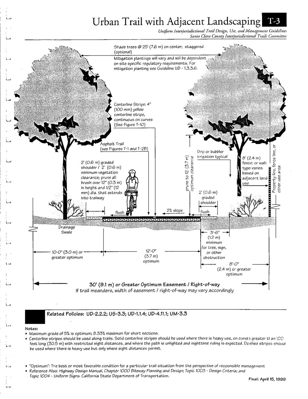
59
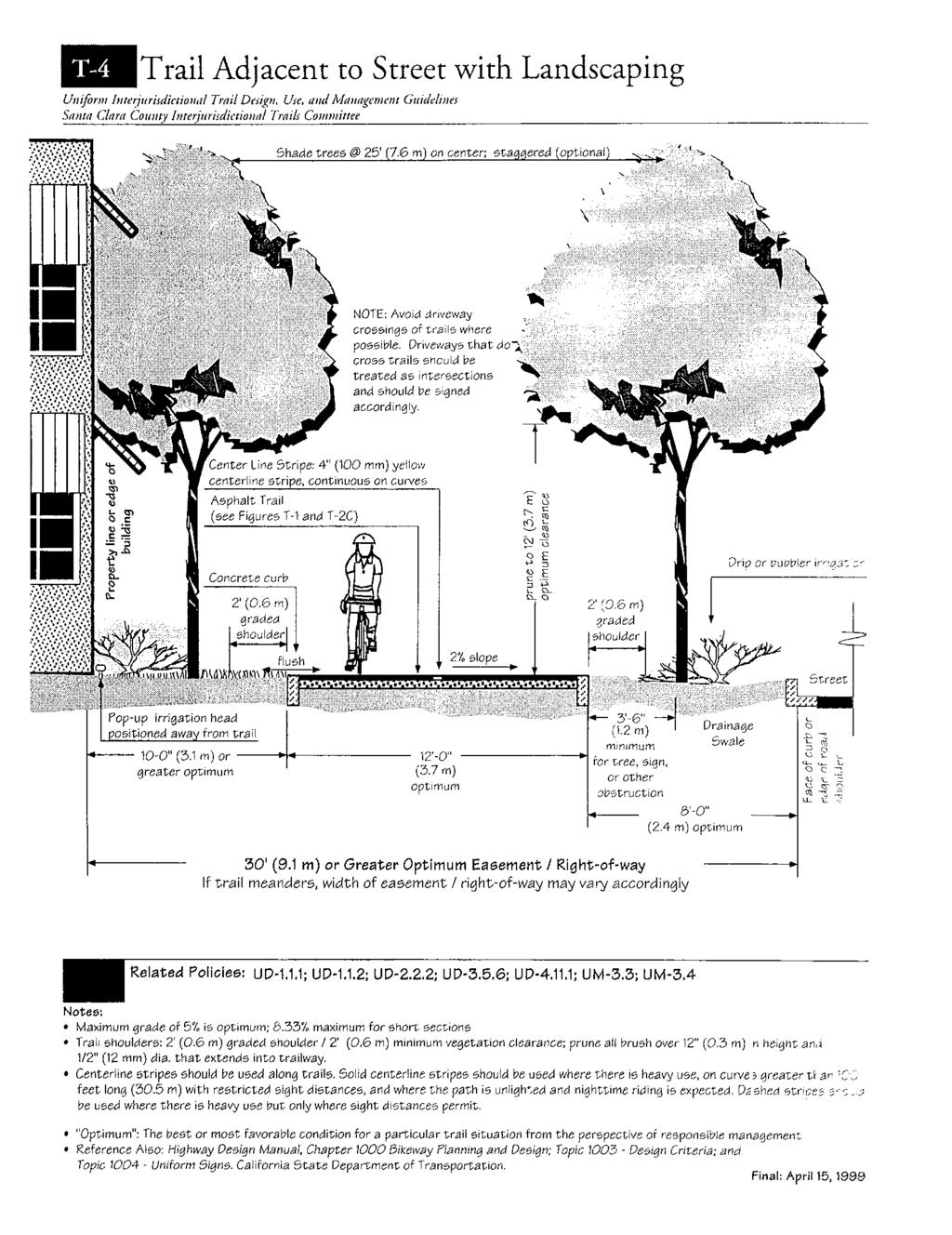
60
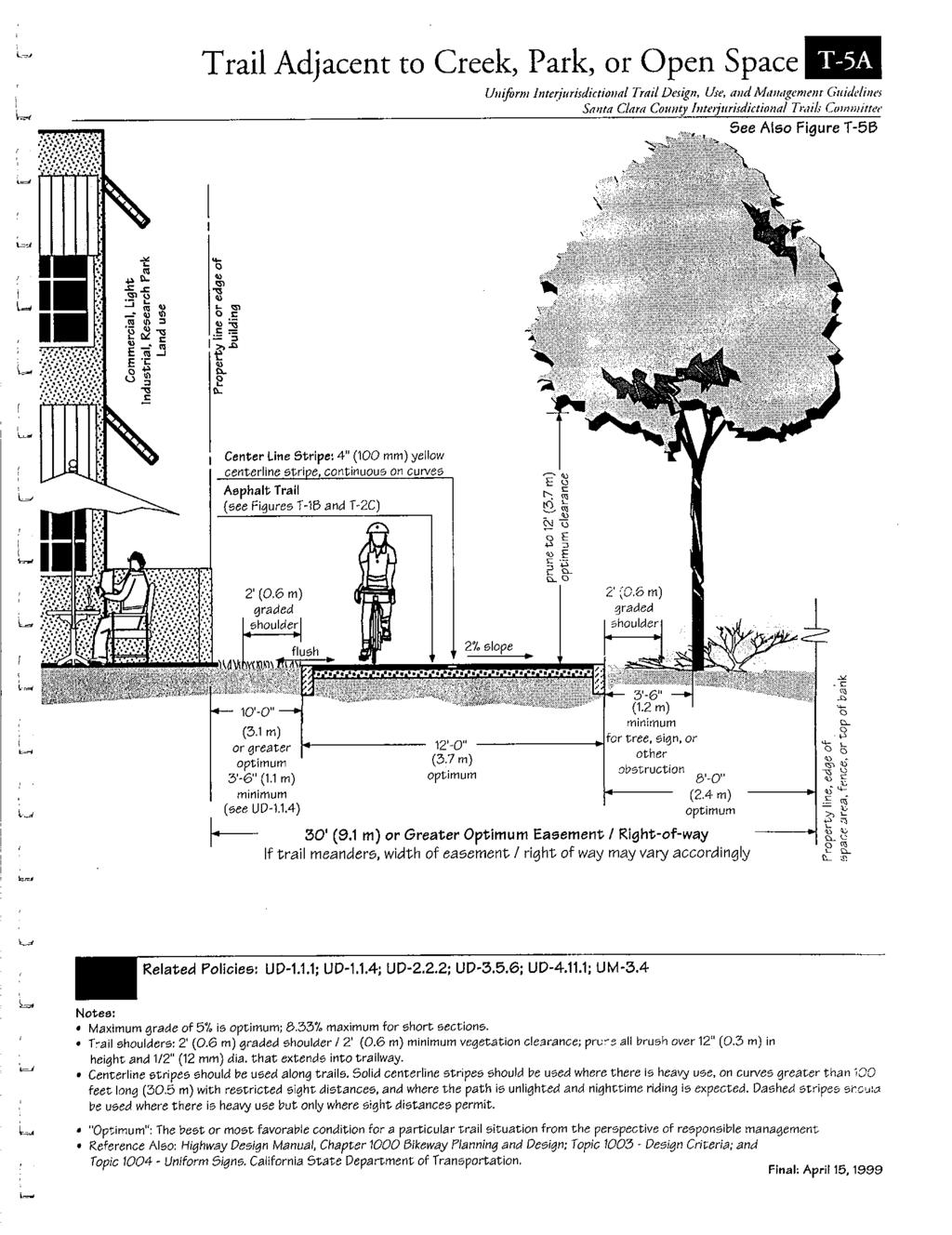
61
62
63
64
65
66
67
68
69
70
71
72
73
74
75
76
77
78
79
80
81
82
83
84
85
86
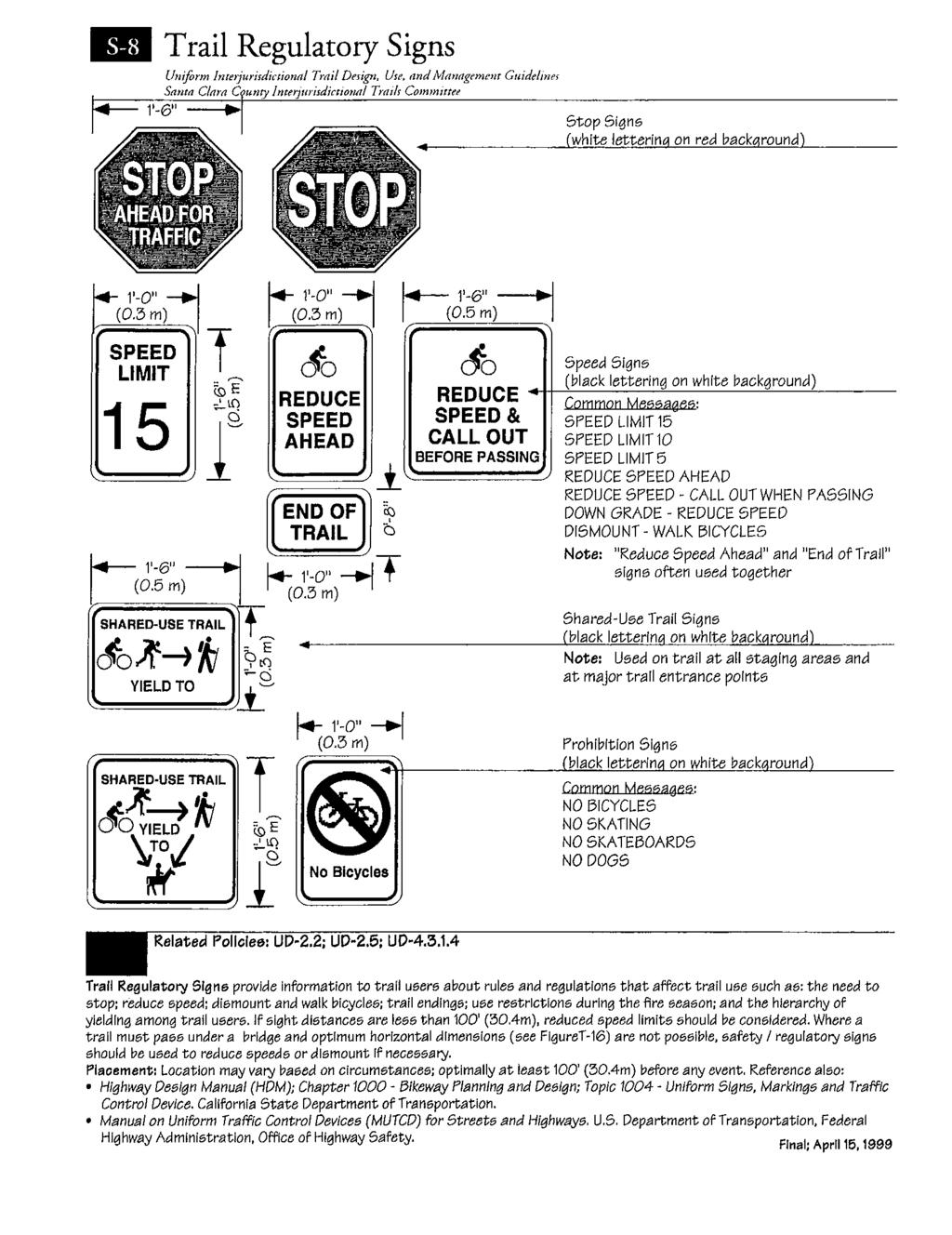
87
FEASIBILITY CRITERIA
 This chapter describes the methodology and criteria used to evaluate the feasibility of developing trails throughout the study areas. Land availability, habitat sensitivity, roadway crossings and on-street
City of Durango 5.8 FUNDING TRAILS DEVELOPMENT
 5.8 FUNDING TRAILS DEVELOPMENT The City has been successful in establishing dedicated local funding sources as well as applying for grants to develop the City s trail system, having received nearly $2.4
Rule Governing the Designation and Establishment of All-Terrain Vehicle Use Trails on State Land
 Rule Governing the Designation and Establishment of All-Terrain Vehicle Use Trails on State Land 1.0 Authority 1.1 This rule is promulgated pursuant to 23 V.S.A. 3506. Section 3506 (b)(4) states that an
MORGAN CREEK GREENWAY Final Report APPENDICES
 APPENDICES MORGAN CREEK GREENWAY Appendix A Photos of Existing Conditions in Trail Corridor Photos of existing conditions Main trail corridor - February 2009 Photos of existing conditions south bank Morgan
The Baker/Carver Regional Trail is intended to
 Section V Design Guidance The Baker/Carver Regional Trail is intended to safely accommodate 183,000 annual visits, an array of non-motorized uses, a variety of skill levels, and persons with special needs.
K SIGNAGE & TRAFFIC CONTROL. Table of Contents
 Table of Contents K1. ACCOMMODATION OF TRAFFIC... 1 K2. MINIMUM CONSTRUCTION SIGNING... 1 K3. SUBDIVISION SIGNS... 2 K4. TRAFFIC CONTROL DEVICES... 2 K4.1 Traffic Signs Regulations... 2 K4.2 Materials...
Blueways: Rivers, lakes, or streams with public access for recreation that includes fishing, nature observation, and opportunities for boating.
 Parks, Open Space and Trails PRINCE WILLIAM COUNTY 2008 COMPREHENSIVE PLAN TRAILS PLAN CONTENTS The components of the trails plan are: Intent Definitions Goals, Policies, and Action Strategies Trails Map
Appendix 3. Greenway Design Standards. The Whitemarsh Township Greenway Plan
 Appendix 3 Greenway Design Standards This chapter discusses two design standards for the greenway types discussed above. First, trail design standards are presented together with trailhead facilities and
CHAPTER III: TRAIL DESIGN STANDARDS, SPECIFICATIONS & PERMITS
 CHAPTER III Trail Design Standards, Specifications & Permits This chapter discusses trail standards, preferred surface types for different activities, permits, and other requirements one must consider
DATE: 23 March, 2011 TO: Communities FROM: BlazeSports America. RE: Accessible Trails Checklist 1
 M E M O R A N D U M DATE: 23 March, 2011 TO: Communities FROM: BlazeSports America RE: Accessible Trails Checklist 1 The purpose of the Accessible Trails Checklist (below) is to help the community review
INTRODUCTION. Mailing address: Burke County Community Development Attn: Tim Johnson P. O. Box 219 Morganton, NC
 REQUEST FOR QUALIFICATIONS: PROFESSIONAL, EXPERIENCED TRAIL BUILDERS FOR THE CONSTRUCTION OF THE FONTA FLORA STATE TRAIL LAKE JAMES SECTION BURKE COUNTY COMMUNITY DEVELOPMENT INTRODUCTION Burke County
Understanding user expectations And planning for long term sustainability 1
 Understanding user expectations And planning for long term sustainability 1 What is a natural surface trail? It can be as simple has a mineral soil, mulched or graveled pathway, or as developed as elevated
Design Considerations For Accessible Parks & Trails
 Design Considerations For Accessible Parks & Trails Measuring Up: Campbell River 2008 Dave Calver Consulting City of Campbell River Legacies Now: Measuring Up Design Guidelines Design Considerations for
Section 61 Recreational Vehicle Park / Campground (Bylaw No. 2012/10)
") Part 7 General Regulations Section 61 Recreational Vehicle Park / Campground (Bylaw No. 2012/10) 61.1 A comprehensive site plan shall be provided to the satisfaction of the Development Authority that shows
Part 7 General Regulations Section 61 Recreational Vehicle Park / Campground (Bylaw No. 2012/10) 61.1 A comprehensive site plan shall be provided to the satisfaction of the Development Authority that shows
EAST DON TRAIL ENVIRONMENTAL ASSESSMENT. Community Liaison Committee Meeting #3 July 15, :30 to 8:30 pm Flemingdon Park Library
 EAST DON TRAIL ENVIRONMENTAL ASSESSMENT Community Liaison Committee Meeting #3 July 15, 2013 6:30 to 8:30 pm Flemingdon Park Library Agenda 1. Welcome 2. Housekeeping and Updates a) Housekeeping b) CLC
Longmont to Boulder Regional Trail Jay Road Connection DRAFT FINAL REPORT
 Longmont to Boulder Regional Trail Jay Road Connection DRAFT FINAL REPORT December 2018 Project Summary Boulder County, Colorado, in partnership with the City of Boulder, is evaluating options for multi-use
SUMMER VILLAGE OF SILVER SANDS. Municipal Development Plan
 SUMMER VILLAGE OF SILVER SANDS Municipal Development Plan Bylaw 253-2014 Adopted August 22, 2014 Summer Village of Silver Sands Municipal Development Plan Bylaw No. 253-2014 Page 2 1 INTRODUCTION 1.1 SETTING
Citrus Heights Creek Corridor Trail Project. Trail Advisory Group Meeting #3 July 8, 2013
 Citrus Heights Creek Corridor Trail Project Trail Advisory Group Meeting #3 July 8, 2013 Agenda Introductions Recap: Community Workshop, Survey Findings, and TAG Field Trip Community Concern Discussion:
At the time, the portion of the line through Eagle County remains wholly under the ownership of Union Pacific Railroad (UP).
.") Chapter 5 The Railroad Corridor as a Trail Corridor The intent of this chapter is to identify how the rail corridor, if available for lease or purchase in all or part, could be incorporated into the core
Chapter 5 The Railroad Corridor as a Trail Corridor The intent of this chapter is to identify how the rail corridor, if available for lease or purchase in all or part, could be incorporated into the core
Chapter 6: POLICY AND PROCEDURE RECOMMENDATIONS
 Chapter 6 POLICY AND PROCEDURE RECOMMENDATIONS FOR SRRA Below are seven policy elements that should be considered for adoption by the Southwest Regional Recreation Authority of Virginia: 1. Develop strategies
2. STAKEHOLDER FEEDBACK // What We Heard
 1. QUARRY ROAD TRAIL // Welcome to the Information Session PROJECT DESCRIPTION WHY WE ARE HERE Quarry Road Trail is a popular commuter trail and recreational area for Calgarians. 1. To report citizen feedback
AGENDA ITEM 5 D WAKULLA ENVIRONMENTAL INSTITUTE (WEI) TRAIL FEASIBILITY STUDY
 TRAIL FEASIBILITY STUDY") March 19, 2018 AGENDA ITEM 5 D WAKULLA ENVIRONMENTAL INSTITUTE (WEI) TRAIL FEASIBILITY STUDY TYPE OF ITEM: Action STATEMENT OF ISSUE The Wakulla Environmental Institute (WEI) Trail is one of several trails
March 19, 2018 AGENDA ITEM 5 D WAKULLA ENVIRONMENTAL INSTITUTE (WEI) TRAIL FEASIBILITY STUDY TYPE OF ITEM: Action STATEMENT OF ISSUE The Wakulla Environmental Institute (WEI) Trail is one of several trails
Theme: Predominately natural/natural appearing; rustic improvements to protect resources. Size*: 2,500 + acres Infrastructure**:
 Recreation Opportunity Spectrum (ROS) Classes The Recreation Opportunity Spectrum (ROS) provides a way to describe the variations in the degree of isolation from the sounds and influences of people, and
Procedure for the Use of Power-Driven Mobility Devices on Mass Audubon Sanctuaries 1 September 17, 2012
 Procedure for the Use of Power-Driven Mobility Devices on Mass Audubon Sanctuaries 1 September 17, 2012 Background As part of Mass Audubon s mission to preserve the nature of Massachusetts for people and
Becker County Trail Routing Feasibility Study
 2016 Becker County Trail Routing Feasibility Study CONNECTING DETROIT MOUNTAIN AND MOUNTAIN VIEW RECREATIONAL AREA TO THE HEARTLAND TRAIL BECKER COUNTY ULTEIG ENGINEERS Contents Acknowledgements...2 INTRODUCTION...3
Railroad Safety Trail
 2.1 INTRODUCTION AND PROJECT SETTING 2.1 Introduction & Project Setting Introduction This study is the result of a directed effort on the part of the City of San Luis Obispo to carry out previously established
COASTAL CONSERVANCY. Staff Recommendation December 2, 2004 COYOTE HELLYER COUNTY PARK BAY AREA RIDGE TRAIL
 COASTAL CONSERVANCY Staff Recommendation December 2, 2004 COYOTE HELLYER COUNTY PARK BAY AREA RIDGE TRAIL File No. 04-057 Project Manager: Amy Hutzel RECOMMENDED ACTION: Authorization to disburse up to
Provincial Railway Technical Standards
 GENERAL: INDEX: The standards and requirements listed in this document are intended for use on provincially regulated railway public grade crossings. These standards are considered the minimum requirements
Outdoor Developed Areas
 The United States Access Board is an independent federal agency that promotes equality for people with disabilities through leadership in accessible design and the development of accessibility guidelines
What s covered. What s not covered. Options for those not covered. ABA Coverage
 The United States Access Board is an independent federal agency that promotes equality for people with disabilities through leadership in accessible design and the development of accessibility guidelines
URBAN DESIGN REPORT. Proposed Residential Development, Old Church Road, Caledon East
 Proposed Residential Development, Old Church Road, Caledon East TABLE CONTENTS: 1.0 DEVELOPMENT 1.1 Introduction-Analysis of Guiding Principles and Documents 1.2 Community Design and Architectural Design
b. Minimum Site Area. Recreational vehicle parks shall be located on a parcel of land not less than 3 acres in area.
 6450 RECREATIONAL VEHICLE PARK REGULATIONS 6450 TITLE AND PURPOSE. The provisions of Section 6450 through 6499, inclusive, shall be known as the Recreational Vehicle Park Regulations. The purpose of these
Mt. Hood National Forest
 United States Department of Agriculture Forest Service Mt. Hood National Forest Zigzag Ranger District 70220 E. Highway 26 Zigzag, OR 97049 503-622-3191 Fax: 503-622-5622 File Code: 1950-1 Date: June 29,
Aspen Skiing Company Policy for Use of Other Power-Driven Mobility Devices And Service Animals
 Aspen Skiing Company Policy for Use of Other Power-Driven Mobility Devices And Service Animals Introduction New rules under the Americans with Disabilities Act (ADA), Titles II and III, went into effect
Snowmobile Trail Signing REF: DNR Trail Signing Handbook
 AWSC FALL WORKSHOP TRAIL SIGNING & MAINTENANCE NOVEMBER 5, 2011 Workshop presenters: Larry Erickson, AWSC Trails Committee Chairman, Iron County Director Dave Peterson, Langlade County Director Snowmobile
The following criteria shall be applied within the boundaries of the AO District:
 Sec. 419 (a) Purpose AIRPORT OVERLAY DISTRICT (AO) The purpose of the Airport Overlay District is to regulate and restrict the height of structures, objects, or natural growth, regulate the locations of
Continental Divide National Scenic Trail Legislative History and Planning Guidance
 Continental Divide National Scenic Trail Legislative History and Planning Guidance Legislation, Policy, and Direction Regarding National Scenic Trails The National Trails System Act, P.L. 90-543, was passed
Appendix A Appendix A (Project Specifications) Auk Auk / Black Diamond (Trail 44) Reroute
 Auk Auk / Black Diamond (Trail 44) Reroute") Appendix A (Project Specifications) Auk Auk / Black Diamond (Trail 44) Reroute I. Proposed Action: This project proposes to reroute approximately 1,800 feet of a 50 inch wide trail, off of private property
Appendix A (Project Specifications) Auk Auk / Black Diamond (Trail 44) Reroute I. Proposed Action: This project proposes to reroute approximately 1,800 feet of a 50 inch wide trail, off of private property
Parkland County Municipal Development Plan Amendment Acheson Industrial Area Structure Plan
 Parkland County Municipal Development Plan Amendment Acheson Industrial Area Structure Plan New Plan Acheson Industrial Area Structure Plan Amendment Parkland County Municipal Development Plan Board Reference
Recreation Opportunity Spectrum for River Management v
 Recreation Opportunity Spectrum for Management v. 120803 Introduction The following Recreation Opportunity Spectrum (ROS) characterizations and matrices mirror the presentation in the ROS Primer and Field
Logo Department Name Agency Organization Organization Address Information 5700 North Sabino Canyon Road
 Logo Department Name Agency Organization Organization Address Information United States Forest Coronado National Forest 5700 North Sabino Canyon Road Department of Service Santa Catalina Ranger District
Lake Apopka Trail Loop Design Guidelines
 November 2002 Prepared for 14908 Tilden Road Winter Garden, FL 34787 Prepared by 140 North Orlando Avenue Suite 295 Winter Park, FL 32789 November, 2002 I. INTRODUCTION...1 II. DESIGN GUIDELINES FOR TRAILS...3
Cultural Resource Management Report Deer Valley 4wd Restoration and Blue Lakes Road Maintenance Project R
 Cultural Resource Management Report R2015-05-03-10005 Undertaking Description: The proposes to perform road maintenance and meadow restoration on the Deer Valley 4wd trail and road maintenance on the Blue
Madison Metro Transit System
 Madison Metro Transit System 1101 East Washington Avenue Madison, Wisconsin, 53703 Administrative Office: 608 266 4904 Fax: 608 267 8778 TO: FROM: SUBJECT: Plan Commission Timothy Sobota, Transit Planner,
Blue River Trail Master Plan JSA to Town Hall June 2004
 Blue River Trail Master Plan JSA to Town Hall June 2004 Prepared for: Silverthorne Town Council Silverthorne SPORT Committee Department of Recreation and Culture Silverthorne Public Works Silverthorne
METROPOLITAN COUNCIL 390 North Robert Street, St. Paul, MN Phone (651) TDD (651)
 TDD (651)") METROPOLITAN COUNCIL 390 North Robert Street, St. Paul, MN 55101 Phone (651) 602 1000 TDD (651) 291 0904 DATE: June 19, 2007 TO: Metropolitan Parks and Open Space Commission FROM: Jan Youngquist, Senior
METROPOLITAN COUNCIL 390 North Robert Street, St. Paul, MN 55101 Phone (651) 602 1000 TDD (651) 291 0904 DATE: June 19, 2007 TO: Metropolitan Parks and Open Space Commission FROM: Jan Youngquist, Senior
ROAD AND TRAIL PROJECT APPROVAL
 ROAD AND TRAIL PROJECT APPROVAL www.marincountyparks.org Marin County Parks, 3501 Civic Center Dr, Suite 260, San Rafael, CA 94903 DATE: July 12, 2017 PRESERVE: Gary Giacomini Open Space Preserve PROJECT:
Flying Cloud Airport (FCM) Zoning Process: Informing a Mn/DOT Path Forward
 Zoning Process: Informing a Mn/DOT Path Forward") : Informing a Mn/DOT Path Forward A Review of the Flying Cloud Airport (FCM) Joint Airport Zoning Board (JAZB) Process and the Draft Airport Zoning Ordinance B A RPZ RPZ A B C Zone Chad E. Leqve Director
: Informing a Mn/DOT Path Forward A Review of the Flying Cloud Airport (FCM) Joint Airport Zoning Board (JAZB) Process and the Draft Airport Zoning Ordinance B A RPZ RPZ A B C Zone Chad E. Leqve Director
APPENDIX D: SUSTAINABLE TRAIL DESIGN. APPENDICES Town of Chili Parks and Recreation Master Plan Update
 APPENDIX D: SUSTAINABLE TRAIL DESIGN APPENDICES Town of Chili Parks and Recreation Master Plan Update Sustainable Trail Construction Sustainable trails are defined by the US Forest Service as trails having
ORDINANCE NO. _2013-
 ORDINANCE NO. _2013- AN ORDINANCE OF THE TOWNSHIP OF CONEWAGO, DAUPHIN COUNTY, PENNSYLVANIA, PROVIDING FOR AIRPORT ZONING REGULATIONS WITHIN THE AIRPORT ZONING OVERLAY DISTRICT CREATED BY THIS ORDINANCE
Appendix C AIRPORT LAYOUT PLANS
 Appendix C AIRPORT LAYOUT PLANS Appendix C AIRPORT LAYOUT PLANS Airport Master Plan Santa Barbara Airport As part of this Airport Master Plan, the Federal Aviation Administration (FAA) requires the development
RULES OF TENNESSEE DEPARTMENT OF TRANSPORTATION AERONAUTICS DIVISION CHAPTER LICENSING AND REGISTRATION OF AIRPORTS TABLE OF CONTENTS
 RULES OF TENNESSEE DEPARTMENT OF TRANSPORTATION AERONAUTICS DIVISION CHAPTER 1680-1-2 LICENSING AND REGISTRATION OF AIRPORTS TABLE OF CONTENTS 1680-1-2-.01 Purpose 1680-1-2-.06 Repealed 1680-1-2-.02 Definitions
DRAFT. Dorabelle Campground Rehabilitation
 DRAFT Dorabelle Campground Rehabilitation September 2012 1.1 REGIONAL SETTING AND PROJECT LOCATION The Dorabelle Campground is located on the western shore of Shaver Lake in Fresno County, California (Section
MPRB: Southwest LRT Community Advisory Committee Issues and Outcomes by Location Current to: 12 November 2010
 MPRB: Southwest LRT Community Advisory Committee Issues and Outcomes by Location Current to: 12 November 2010 This is a compilation of issues and outcomes identified by the CAC. It is a work in progress,
VAR-501-WECC-3 Power System Stabilizer. A. Introduction
 A. Introduction 1. Title: Power System Stabilizer (PSS) 2. Number: VAR-501-WECC-3 3. Purpose: To ensure the Western Interconnection is operated in a coordinated manner under normal and abnormal conditions
NATIONAL PARK SERVICE CERTIFICATION OF COMPLETED SEGMENTS OF THE NORTH COUNTRY NATIONAL SCENIC TRAIL
 NATIONAL PARK SERVICE CERTIFICATION OF COMPLETED SEGMENTS OF THE NORTH COUNTRY NATIONAL SCENIC TRAIL Completed trail segments that (1) follow the route identified in the 1982 National Park Service (NPS)
Park Design and Location Criteria
 Park Design and Location Criteria This section is presented in the interest of assisting park and recreation agencies in the development of a system of parks and recreation areas. A recreation system is
National Forests and Grasslands in Texas
 United States Department of Agriculture Forest Service National Forests and Grasslands in Texas Sam Houston NF 394 FM 1375 West New Waverly, Texas 77358 Phone 936-344-6205 Dear Friends, File Code: 1950
Permeable RECREATIONAL TRAILS
 SMART EARTH SOLUTIONS Permeable RECREATIONAL TRAILS GEOWEB GEOPAVE GEOTERRA Innovative Solutions for Designing & Building Trails. Trail Surface Stabilization The key to planning and building trails into
Chapter 4.0 Alternatives Analysis
 Chapter 4.0 Alternatives Analysis Chapter 1 accumulated the baseline of existing airport data, Chapter 2 presented the outlook for the future in terms of operational activity, Chapter 3 defined the facilities
Northeast Stoney Trail In Calgary, Alberta
 aci Acoustical Consultants Inc. 5031 210 Street Edmonton, Alberta, Canada T6M 0A8 Phone: (780) 414-6373, Fax: (780) 414-6376 www.aciacoustical.com Environmental Noise Computer Modelling For Northeast Stoney
4. Safety Concerns Potential Short and Medium-Term Improvements
 NH Route 104 Access Management Study Page 19 4. Safety Concerns Potential Short and Medium-Term Improvements Potential safety improvement strategies are listed by priority based on field observations by
Georgetown-Lewes Rail/Trail Study. Rail/Trail Study: Cool Spring to Cape Henlopen State Park New Road Extension (House Resolution No.
 Georgetown-Lewes Rail/Trail Study Rail/Trail Study: Cool Spring to Cape Henlopen State Park New Road Extension (House Resolution No. 47) August 22, 2011 Presentation Outline Background Benefits Statewide
THRESHOLD GUIDELINES FOR AVALANCHE SAFETY MEASURES
 BRITISH COLUMBIA MINISTRY OF TRANSPORTATION & INFRASTRUCTURE AVALANCHE & WEATHER PROGRAMS THRESHOLD GUIDELINES FOR AVALANCHE SAFETY MEASURES British Columbia Ministry of Transportation & Infrastructure
PURPOSE AND NEED (CONCURRENCE POINT 1) NEW CANADA ROAD PROJECT FROM STATE ROUTE 1 (U.S. HIGHWAY 70) TO U.S. INTERSTATE 40
 NEW CANADA ROAD PROJECT FROM STATE ROUTE 1 (U.S. HIGHWAY 70) TO U.S. INTERSTATE 40") PURPOSE AND NEED (CONCURRENCE POINT 1) NEW CANADA ROAD PROJECT FROM STATE ROUTE 1 (U.S. HIGHWAY 70) TO U.S. INTERSTATE 40 Project Description The primary purpose of this project is to improve the major
PURPOSE AND NEED (CONCURRENCE POINT 1) NEW CANADA ROAD PROJECT FROM STATE ROUTE 1 (U.S. HIGHWAY 70) TO U.S. INTERSTATE 40 Project Description The primary purpose of this project is to improve the major
Bradley Brook Relocation Project. Scoping Notice. Saco Ranger District. United States Department of Agriculture Forest Service
 Bradley Brook Relocation Project United States Department of Agriculture Forest Service Scoping Notice White Mountain National Forest February 2011 For Information Contact: Jenny Burnett White Mountain
WELCOME to the Iditarod Dog Sledding Historic District (IDSHD) Workshop. January 11, Houston Middle School Houston, Alaska
 Workshop. January 11, Houston Middle School Houston, Alaska") WELCOME to the Iditarod Dog Sledding Historic District (IDSHD) Workshop January 11, 2012 Houston Middle School Houston, Alaska Workshop Purpose: Present/discuss proposed resolutions to comments received
WELCOME to the Iditarod Dog Sledding Historic District (IDSHD) Workshop January 11, 2012 Houston Middle School Houston, Alaska Workshop Purpose: Present/discuss proposed resolutions to comments received
Draft Concept Alternatives Analysis for the Inaugural Airport Program September 2005
 Section 10 Preferred Inaugural Airport Concept 10.0 Introduction The Preferred Inaugural Airport Concept for SSA was developed by adding the preferred support/ancillary facilities selected in Section 9
Daisy Dean Trail 628/619 ATV Trail Construction
 Background and Purpose and Need The Daisy Dean ATV Trail Construction Project is located in the Little Belt Mountains, Musselshell Ranger District, Lewis and Clark National Forest approximately 32 miles
Airport Design-3 Geometric Design
 Airport Design-3 Geometric Design When designing airport runways, engineers and other planners have many factors to consider. These include the type and volume of air traffic, the impact of noise, and
LYNDHURST NEW URBAN DEVELOPMENT AREA STRUCTURE PLAN. Lyndhurst New Urban Development Area Structure Plan OUTCOMES AND PERFORMANCE STANDARDS
 APPENDIX 15.1-3 LYNDHURST NEW URBAN DEVELOPMENT AREA STRUCTURE PLAN Purpose of the Structure Plan Lyndhurst New Urban Development Area Structure Plan OUTCOMES AND PERFORMANCE STANDARDS LSP-P1 The District
Flow Stand Up Paddle Board Parkway Plan Analysis
 Regional Parks Department Jeffrey R. Leatherman, Director County of Sacramento Divisions Administration Golf Leisure Services Maintenance Rangers Therapeutic Recreation Services Flow Stand Up Paddle Board
City of Redding Airports
 City of Redding Airports Benton Airpark Redding Municipal Airport DEVELOPMENT AND USE GUIDELINES FOR GENERAL AVIATION HANGARS April 7, 2009 PREFACE The City of Redding, as owner of federally obligated
APPLICATION FOR SITE DEVELOPMENT PLAN LETTER OF INTENT Amended
 Est. 1982 Est. 1982 Urban Planning Community Design Landscape Architecture 731 North Weber Street, Suite 10, Colorado Springs, CO 80903, 719 633-9700 http://www.gumanltd.com/ Members American society of
PIONEER PARK. City of Des Peres Parks Master Plan. SWT Design 46 INTRODUCTION
 PIONEER PARK INTRODUCTION Pioneer Park is a 7 acre neighborhood park located east of Interstate 270 and south of Manchester Road along Tallie Road. The park is situated in a residential neighborhood with
Section 3-04 Cross Sectional Elements TABLE OF CONTENTS. INTRODUCTION...3 General...3 Exhibit 1-Cross-Sectional Elements...3
 Section 3-04 Cross Sectional Elements TABLE OF CONTENTS INTRODUCTION...3 General...3 Exhibit 1-Cross-Sectional Elements...3 CROSS-SECTIONAL ELEMENTS...3 Traveled Way...3 Shoulder...3 Surfacing Taper...3
St. Paul Downtown Airport (STP)
") Reliever Airports: NOISE ABATEMENT PLAN St. Paul Downtown Airport (STP) 1 INTRODUCTION The noise abatement plan for the St. Paul Downtown Airport (STP) was prepared in recognition of the need to make the
Reliever Airports: NOISE ABATEMENT PLAN St. Paul Downtown Airport (STP) 1 INTRODUCTION The noise abatement plan for the St. Paul Downtown Airport (STP) was prepared in recognition of the need to make the
NEWBORO AND PORTLAND HARBOUR REDVELOPMENT PLANS
 INTRODUCTION The Municipal docks in both Newboro and Portland were transferred to the Township of Rideau Lakes by Parks Canada in 2002. Little has been done to improve the docks physical condition or role
Chapter Six ALP Drawings. Tacoma Narrows Airport. Master Plan Update
 Chapter Six ALP Drawings Master Plan Update The master planning process for the (Airport) has evolved through efforts in the previous chapters to analyze future aviation demand, establish airside and landside
Public Notice ISSUED: December 10, 2018 EXPIRES: January 9, 2019
 APPLICANT: REFER TO: St. Louis and Lake Counties Regional Rail Authority 2018-01942-ARC Public Notice ISSUED: December 10, 2018 EXPIRES: January 9, 2019 SECTION:404 - Clean Water Act 1. APPLICATION FOR
Rural Rustic Road Program
 Virginia Department of Transportation s Rural Rustic Road Program Prepared by the Local Assistance Division Virginia Department of Transportation 1401 East Broad Street Richmond, Virginia 23219 Michael
WASHINGTON STATE PARKS AND RECREATION COMMISSION POLICY/PROCEDURE
 WASHINGTON STATE PARKS AND RECREATION COMMISSION POLICY/PROCEDURE 65-13-1 Use of Other Power-Driven Mobility Devices by Persons with Mobility Disabilities at State Park Facilities See Also: 28 CFR 35 Title
COASTAL CONSERVANCY. Staff Recommendation September 22, 2011 BAY AREA RIDGE TRAIL: HOOD MOUNTAIN TO HIGHWAY 12
 COASTAL CONSERVANCY Staff Recommendation September 22, 2011 BAY AREA RIDGE TRAIL: HOOD MOUNTAIN TO HIGHWAY 12 File No. 11-039-001 Project Manager: Betsy Wilson RECOMMENDED ACTION: Authorization to disburse
AIRPORT LAND USE COMPATILIBILTY AIRPORT LAND USE COMPATIBILIITY
 CHAPTER 7 AIRPORT LAND USE COMPATILIBILTY CHAPTER 7 AIRPORT LAND USE COMPATIBILIITY 7.0 INTRODUCTION On airport aviation related development is typically compatible with aircraft operations. On airport
Consideration will be given to other methods of compliance which may be presented to the Authority.
 Advisory Circular AC 139-10 Revision 1 Control of Obstacles 27 April 2007 General Civil Aviation Authority advisory circulars (AC) contain information about standards, practices and procedures that the
Committee Report. Community Development Committee For the Metropolitan Council meeting of April 13, Business Item No.
 Committee Report Business Item No. 2016-48 Community Development Committee For the Metropolitan Council meeting of April 13, 2016 Subject: Harriet Island-South St. Paul Regional Trail Master Plan, Saint
Auburn Trail / Ontario Pathways Trail Connector Feasibility Study Public Information Meeting Wednesday, August 22, 2012
 Auburn Trail / Ontario Pathways Trail Connector Feasibility Study Public Information Meeting Wednesday, August 22, 2012 Purpose of Feasibility Study Purpose Evaluate the feasibility of constructing a multiuse
Other Principle Arterials Minor Arterial Major Collector Minor Collector Local
 CHAPTER 10 TRANSPORTATION Introduction The system of public roads in East Pikeland Township is decidedly rural in character. Since the 1984, the road network has remained much the same, with the addition
Trail # NW Tuesday, June DESIGN. Provide an Review the Provide an. Project Goals: System system. wayfinding
 I. Welcome / Introductions Bethany Creek Trail #2 Segment 3 Neighborhood Meeting #1 Bethany Presbyterian Church 15505 NW Springville Road, Portland, OR 97229 Tuesday, June 26, 2018 @ 6:00PM Meeting Minutes
3. COLTA / HUGA CONNECTIONS - PRELIMINARY
 9 3. COLTA / HUGA CONNECTIONS - PRELIMINARY 3.1 COLTA The Chain of Lakes Trail Association (COLTA) trail, formerly identified as the Chester Spur Line, was completed and opened for use in June 2011. The
Trails Design and Management Handbook
 Trails Design and Management Handbook OPEN SPACE PITKIN AND TRAILS COUNTY Open Space and Tr ails Progr am Pitkin County, Color ado Pitkin County Open Space and Trails Program Trails Design and Management
EXECUTIVE SUMMARY PROGRAM DEVELOPMENT REPORT PURPOSE EXISTING SETTING EXPANDING PARKLAND
 EXECUTIVE SUMMARY PROGRAM DEVELOPMENT REPORT PURPOSE As the culmination of the first phase of the master planning process, this Program Development Report creates the framework to develop the Calero County
DRAFT FINAL ACCESSIBILITY GUIDELINES FOR OUTDOOR DEVELOPED AREAS
 Date: October 19, 2009 DRAFT FINAL ACCESSIBILITY GUIDELINES FOR OUTDOOR DEVELOPED AREAS Introduction Background Whom Guidelines Apply To How to Submit Comments Contact for Further Information General Issues:
I507 Devonport Naval Base Precinct
 I507. Devonport Naval Base I507.1. Precinct Description The Devonport Naval Base precinct covers most of the land held by the Crown for the HMNZ Naval Base (south yard) in Devonport. It incorporates the
D1 January 8, 2014 Public Hearing APPLICANT: HUNT CLUB FARM
 D1 January 8, 2014 Public Hearing APPLICANT: HUNT CLUB FARM PROPERTY OWNER: HUNT CLUB A-1- A, LLC. STAFF PLANNER: Kevin Kemp REQUEST: Modification of a Conditional Use Permit approved by the City Council
Interstate 90 and Mercer Island Mobility Study APRIL Commissioned by. Prepared by
 Interstate 90 and Mercer Island Mobility Study APRIL 2017 Commissioned by Prepared by Interstate 90 and Mercer Island Mobility Study Commissioned by: Sound Transit Prepared by: April 2017 Contents Section
Welcome to the future of Terwillegar Park a Unique Natural Park
 Welcome to the future of Terwillegar Park a Unique Natural Park 1 Introduction The Terwillegar Park Concept Plan study will develop an overall concept plan, management objectives and development guidelines
River Parks Trail: Tulsa, Oklahoma
 River Parks Trail: Tulsa, Oklahoma Purpose: The purpose of the River Parks Trail is to maintain, preserve, develop, and promote the Arkansas River for the economic and cultural benefit of the community.
Non-Motorized Transportation
 Non-Motorized Transportation Non-motorized facilities are important components to the transportation system. They provide an environmentally-friendly, low-cost mode of travel. Some of the facilities can
Lafourche Parish Government REQUEST FOR QUALIFICATIONS. Landscape Architectural Services
 Lafourche Parish Government REQUEST FOR QUALIFICATIONS Landscape Architectural Services Bayou Lafourche Parish Multi-Use Path Feasibility Study Phase 1 And Bayou Lafourche Parish Multi-Use Path Feasibility