This Passport: Revised October 20, 2017, EAM # Discovering the Trails of Webster, NY
|
|
|
- Richard Andrews
- 6 years ago
- Views:
Transcription


1 This Passport: Revised October 20, 2017, EAM # Discovering the Trails of Webster, NY
2 The Town of Webster invites you to explore and experience our diverse outdoor adventures! Here s your opportunity to discover the beauty and solitude of nature, a variety of wildlife, the magnificence of natural settings, and the health benefits of being more active all in your own backyard! Share the wonders of the great outdoors with family and friends and get to know your region up close and personal. The Wegmans Hit the Trail Passport program runs from March 1 October 31. If you d like to enter your completed passport for a chance to win a $ Wegmans gift card and a free rental of Liberty Lodge at Finn Park (M Th only), please bring it to the Webster Recreation Center, 1350 Chiyoda Drive, by November 1. Any questions? Stop in or give the Webster Recreation Center a call at ext.0. Disclaimer: The producers and sponsors of the maps and texts in this booklet have made every effort to present accurate, up-to-date information. However, trail and access conditions may vary because of weather, property ownership, management and maintenance practices, or other factors. Due to re-sizing, the maps are not to scale. The producers and sponsors of this booklet and the PASSPORT program are in no way responsible for personal injury, damage to property, or violation of law in connection with the use of this booklet. Remember to only use open and designated trails. When in doubt, ask for permission. Visit


3 The Town of Webster is fortunate to have a wide variety of natural resources which make for many unique and picturesque trails. We hope you will enjoy and protect our environment. Always be safe and please leave the trails the same way you found them. The Friends of Webster Trails is a volunteer group and functions as part of the Town of Webster. Their trail stewardship is widely recognized and greatly appreciated. Please see our website ( if you are interested in volunteering or would like more information about this dedicated group.
4 Join the Friends of Webster Trails, Webster Health and Education Network, the Town of Webster and Wegmans to get moving more and enjoy area trails. Ron Nesbitt Webster Town Supervisor Visit: The Wegmans Passport to Family Wellness is an on-going program sponsored by Wegmans. For more information on trail maps, contact Friends of Webster Trails at 1
5 Playground Parking Kodak Run 2

6 Webster Arboretum Location: on Schlegel Road, between Salt & Basket Difficulty: Very Easy Length: 1.3 miles Features: The Webster Arboretum is a place to see a unique garden of natural beauty. The site is multi-use to include leisure, educational and cultural activities in a natural setting. It also enhances awareness of the value, beauty and need for protection of our botanical resources. It offers quiet reflection, beauty, sight, smell and sounds of nature. *Walking, Hiking, Jogging, Snowshoeing, Cross Country Skiing MAKE TRAIL MARKER RUBBING HERE indicates TRAIL MARKER. 3
7 4 Hojack Trail

8 Bird Sanctuary Trail Location: off Orchard Street, north of North Ponds Park Difficulty: Very Easy Length: approximately 0.80 miles Features: The Bird Sanctuary Trail is a linear trail between the North Ponds Park walking path, Hojack Trail, State Route 250 and the Chiyoda Trail. *Walking, Jogging, Hiking, Biking, Snowshoeing, Cross Country Skiing MAKE TRAIL MARKER RUBBING HERE indicates TRAIL MARKER. 5
9 Phillips Road Chiyoda Drive Chiyoda Trail Parking Webster Parks & Recreation Office To Bird Sanctuary Trail on east side of Rt Webster Road Rt. 250
10 Chiyoda Trail Location: 1350 Chiyoda Drive (Webster Recreation Center) off Phillips Road, across from Xerox Difficulty: Easy Length: 1.27 miles (One mile is paved loop, remaining 0.27 miles are in the woods.) Features: This is a paved loop trail located on the Webster Recreation Property. The trail winds through trees and loops back to the fitness facility. The trail (.27 miles) connects to the Bird Sanctuary Trail on the east side of State Route 250. *Walking, Hiking, Jogging, Biking, Snowshoeing, Cross Country Skiing MAKE TRAIL MARKER RUBBING HERE indicates TRAIL MARKER. 7
11 8

12 Finn Park Nature Trail Location: off Maple Drive, north of Route 104 Difficulty: Easy Length: 1.25 miles Features: Finn Park consists of 50 acres of land located just north of Route 104 between Maple Road and Gravel Road. Parking can be found at Liberty Lodge, off Maple Drive. The trail begins in the woodlot behind Liberty Lodge. Start at the southeast corner of the Liberty Lodge lawn. The trail travels 0.25 mile, over a small stream, through a mature beech forest, to a perimeter trail around a meadow. This meadow trail circles 0.75 mile around ideal monarch butterfly habitat. The footpath parallels Shipbuilder s Creek before finally looping back. Follow the wooded trail back to Liberty Lodge. *Walking, Hiking, Jogging, Snowshoeing, Cross Country Skiing MAKE TRAIL MARKER RUBBING HERE indicates TRAIL MARKER. 9
13 10 Fishing is permitted (license required) in Four Mile Creek and Salt Creek. Please refer to for specific details on obtaining a fishing license. Special Great Lakes Tributary regulations apply on Four Mile Creek. See
14 Four Mile Creek Preserve Location: The parking lot is at the corner of Phillips and Lake Roads, 160 Phillips Rd (N ', W '). Difficulty: Easy Length: Blue Loop Trail.75 miles Red Loop Trail 1.4 miles Features: The park consists of 72 acres purchased in 2004 by the Town of Webster under the open space referendum. The preserve features sections of Four Mile Creek and its major tributary, Salt Creek. Both are prime fishing waters. There are a variety of ecosystems such as old growth forest, succession forest, and wetlands. Fishing is permitted (license required) in Four Mile Creek and Salt Creek. Hunting will be by special Town permit only. Motorized vehicles, fires, camping, firearms and trapping are prohibited. *Walking, Biking, Snowshoeing, Cross Country Skiing MAKE TRAIL MARKER RUBBING HERE indicates TRAIL MARKER. 11
15 12
16 Gosnell Big Woods Preserve GO TO BACK PAGE OF BOOK TO MAKE TRAIL MARKER RUBBINGS Location: parking lot is at the corner of Vosburg and Drumm Roads. Big Field Trail is an easy 1.2 mile trail that follows the perimeter of the field. The trailhead is at the parking lot at the corner of Vosburg Road and Drumm Road. This trail provides beautiful views of the grassland field and wildflowers. Walks on this trail may include seeing turkeys, deer and a variety of birds. This trail is great for cross country skiing. Big Woods Trail is a moderate 0.8 mile trail that starts from the Big Field Trail 0.2 mile north of the parking lot. In an effort to not disturb the natural character of the woods, there are no blazes to mark the trail and minimal trail clearing. The trail is easy to follow and the reward is the spectacular beauty of the Big Woods. Meadow Trail is an easy 0.5 mile trail that starts from the Big Field Trail 0.1 mile north of the parking lot. It goes east into a small meadow and then loops back to the west through woods connecting to the Big Woods Trail between the Big Field Trail and the Overlook Trail. *Walking, Hiking, Jogging, Snowshoeing, Cross Country Skiing NO BIKES ALLOWED. indicates TRAIL MARKER. 13
17 14
18 Hojak Trail Location: follows rail bed from Lake Road to Phillips Road Difficulty: Very Easy Length: 4.95 miles Features: The Hojack Trail is a walking and biking trail from Lake Road, past North Ponds Park, to Phillips Road on the railbed of the abandoned Hojack Line. Parking is available at Vosburg Hollow Nature Preserve, North Ponds and the cross roads. *Walking, Hiking, Jogging, Snowshoeing, Cross Country Skiing, Biking MAKE TRAIL MARKER RUBBING HERE indicates TRAIL MARKER. 15
19 16 250
20 North Ponds Park Location: off Rt. 104, between Holt Road & Rt. 250 Difficulty: Very Easy Length: 1 mile Features: Paved loop path. The park offers 8 handicap fitness stations and a sledding hill at the north end of the park. Parking is available just off Route 104 and in a lot on Orchard Street. The ponds are also open for fishing. *Walking, Hiking, Jogging, Biking, Snowshoeing, Cross Country Skiing MAKE TRAIL MARKER RUBBING HERE * Don t forget the Rt. 104 Bike Path GO TO BACK PAGE OF BOOK TO MAKE TRAIL MARKER RUBBING Location: Runs between Salt and Bay Roads. Start at Bay Road to mile marker at Hard Road, (2.6 miles) or start at Salt Road to mile marker (3.5 miles). Length: 6.1 miles total indicates TRAIL MARKER. 17
21 Hojack Trail Parking To Gosnell Big Woods 18

22 Vosburg Hollow Nature Trail Location: Park in the area behind the pumping station and take the Hojack Trail 1/8 mile to the trail on the left. Difficulty: Easy Length:.25 miles southwest of Vosburg Road Features: It leads north along a stand of red pines and descends to a boardwalk across a marshy area. It ends in a glade of flowers and ground cover next to Shipbuilders Creek. Take the bridge over Shipbuilders Creek and climb the stairs up to the parking area. *Walking, Hiking, Jogging, Snowshoeing MAKE TRAIL MARKER RUBBING HERE indicates TRAIL MARKER. 19
23 20
24 Whiting Road Nature Preserve -- GO TO BACK PAGE OF BOOK TO MAKE TRAIL MARKER RUBBINGS -- Location: between Pellett and Whiting Roads, south of Lake Rd. Park at the parking area on Whiting Rd. Trail/Difficulty/Length/Features: Blue Trail, very easy, level walk,.70 mile provides access through the shrub-seedling and sapling-pole forest adjacent to Whiting Road. Brown Trail, easy, level trail,.40 mile through a grassy field. Green Trail, moderate walk, 1.20 miles through young to mature forest north of the red trail. Orange Trail, easy, mostly level walk with a couple of moderate slopes, 1.40 mile provides access to the primarily grass-forb and shrub-seedling areas and some mature woods. Red Trail, moderate with long slopes, 1.40 mile provides access to the mature to climax beech forest on the western part of the preserve. Yellow Trail, moderate walk: a rolling terrain with a couple of short, steep slopes,.55 mile provides access through the young to mature growth forest west of the blue trail. *Walking, Hiking, Biking, Jogging, Snowshoeing, Cross Country Skiing indicates TRAIL MARKER. 21
25 22 Connecting Trail to Whiting Road Nature Preserve parking lot.64 mile

26 Webster Park Location: off Holt and Lake Roads Difficulty: Easy Length: Valley View Trail is.6 miles Length: West Trail is 1.6 miles Features: Discover 550 acres of beautiful, evergreenplanted slopes, rolling lakeshore breakers and cool green valleys. The East Trail passes through a former orchard that is filled with seckle pear, apple, crabapple, and cherry trees. This trail is full of birds in the spring and summer months. The West Trail features wooded areas which are a great habitat for wild turkey. Additional information on Trails at Webster Park: *Walking, Hiking, Jogging, Snowshoeing, Cross Country Skiing Biking prohibited on Webster Park trails. MAKE TRAIL MARKER RUBBING HERE indicates TRAIL MARKERS. ROOM FOR ADDITIONAL RUBBING AT BACK OF PASSPORT. 23
27 Midnight Trail Location: Entrance to Midnight Trail is via Webster Park at 999 Lake Rd. Trail is south of the Webster camp sites and the Mohawk Lodge. You can also park at the Whiting Road Nature Preserve, 403 Whiting Rd (N ', W '), and walk east on the trail that connects from Whiting Road to Webster Park s West Loop and the Mohawk Lodge. Signs are posted to assist you. Difficulty: Easy, with a couple moderate slopes. Length:.67 miles Features: Wide paths that meander in a loop around primarily old beech trees. There are several interior trails that bring you to a picnic area (please, carryin/carry-out your picnic trash). These multi-use trails are great for walking, running, cross country skiing, and snowshoeing. Cyclists should access the Midnight Trail via the road which starts at 999 Lake Rd and goes south to the Mohawk Lodge and the Midnight Trail. Biking prohibited on Webster Park trails. indicates TRAIL MARKERS. ROOM FOR ADDITIONAL RUBBING AT BACK OF PASSPORT. 25

28 MAKE TRAIL MARKER RUBBING HERE MAKE TRAIL MARKER RUBBING HERE MAKE TRAIL MARKER RUBBING HERE MAKE TRAIL MARKER RUBBING HERE 29
29 24
30 MAKE TRAIL MARKER RUBBING HERE MAKE TRAIL MARKER RUBBING HERE MAKE TRAIL MARKER RUBBING HERE MAKE TRAIL MARKER RUBBING HERE 30
31 MAKE TRAIL MARKER RUBBING HERE This Passport Belongs to: Name Age Address Phone Field Notes: 31
32 TRAIL RECORD Date Trail Page 32
33 Please look for a trail marker like the one illustrated below on each trail. Trail markers are mounted on 4x4 posts. When you locate a trail marker, use a pencil or crayon to rub the name of the trail on the corresponding page of your passport. To record your visit to this trail, find the page for this trail in your Wegmans Passport to Family Wellness and make a rubbing of the box below using a pencil or crayon. WEBSTER ARBORETUM PASSPORT to family wellness Discovering the Trails of Webster, NY Visit
34
PASSPORT. Discovering the Trails of Webster, NY
 PASSPORT to family wellness Discovering the Trails of Webster, NY Join the Friends of Webster Trails, Webster Health and Education Network, The Town of Webster and Wegmans to get moving more and enjoy
This Passport: Revised October 20, 2017, EAM # Discovering the Trails of Penfield, NY
 This Passport: Revised October 20, 2017, EAM #161922 Discovering the Trails of Penfield, NY The Town of Penfield is fortunate to have a wide variety of natural resources which make for many unique and
This Passport: Revised March 20, 2017, EAM # Discover the Trails of Perinton, NY
 This Passport: Revised March 20, 2017, EAM #161921 Discover the Trails of Perinton, NY The Town of Perinton invites you to explore and experience our diverse outdoor adventures! Here s your opportunity
BOOK 2. Discover Wayne County Trails. Trail Works, Inc. is a volunteer group dedicated to trail development and use.
 Trail Works, Inc. is a volunteer group dedicated to trail development and use. Your membership in Trail Works insures that healthy programs like this continue to thrive. Join today at www.trailworks.org
Discovering the Trails of Henrietta, NY
 This Passport: Revised June 8, 2017, EAM #161919 The Town of Henrietta is fortunate to have many wonderful trails to explore. We hope you will enjoy and protect our environment. Always be safe and please
A Publication of Friends of Sleeping Bear Dunes
 A Publication of Friends of Sleeping Bear Dunes 2014, Friends of Sleeping Bear Dunes, P.O. Box 545, Empire, MI 49630 www.friendsofsleepingbear.org info@friendsofsleepingbear.org Learn more about the Friends
MONTGOMERY TOWNSHIP OPEN SPACE & PATHWAYS COMMITTEE
 MONTGOMERY TOWNSHIP OPEN SPACE & PATHWAYS COMMITTEE Meetings: 2 nd Wednesday of each month @ 6:30 PM in the Municipal Building Questions? Call the Open Space Coordinator, Lauren Wasilauski, at (908) 359-8211
proof Northwest District
 1 Northwest District The Northwest Florida Water Management District is the most rural of all five water management districts. From just east of Tallahassee west to the Florida/Alabama line, and from the
CRAZY HORSE TRAIL GUIDE
 CRAZY HORSE TRAIL GUIDE Abridged Version: July 2016 This is a short form of our interpretive trail guide for the Crazy Horse Trail. The full version of the guide has a more detailed description of the
IOWA ORNITHOLOGISTS' UNION - Birding Sites in Dallas County
 IOWA ORNITHOLOGISTS' UNION - Birding Sites in Dallas County Printed on 7/19/2018 Beaver Bottoms Wetland (restricted) (Important Bird Area) GPS Coordinates:, Ownership: Private (see directions for access)
Explore your Town With The Kingston Area Trail Passport
 Explore your Town With The Kingston Area Trail Passport Don t forget to stop at the children's room in the library for your prize when you collect 5 Passport Stamps! For more natural resource related information,
To Wellness. To Wellness PASSPORT PASSPORT. Partners. Partners. Ashland County Health & Human Services 630 Sanborn Avenue, Ashland, WI
 Partners Ashland County Health & Human Services 630 Sanborn Avenue, Ashland, WI Ashland Bretting Center 320 4th Avenue W., Ashland, WI PASSPORT Bayfield County Health Department 117 E. 6th Street, Washburn,
Stephens State Park Trails
 TRAILS OF ALLAMUCHY MOUNTAIN & STEPHENS STATE PARKS Allamuchy Mountain and Stephens State Parks contain 28 marked trails providing access to diverse landscapes for walking, hiking, biking, bird-watching,
Calvert Regional Park - Tari Moore Recreational Trail. Calvert Regional Park - Woodland Trail. miles from Rising Sun
 Calvert Regional Park - Tari Moore Recreational Trail 304 Brick Meeting House Road, North East, MD 21901 5.2 about 1.1 mile Paved parking lot, plentiful Easy, paved path with slight incline. Easy, paved
Walking Tips. Locations. Good luck on your journey to better health! Earleigh Heights Ranger Station
 Walking Tips Dress in Layers The weather and even your own body temperature can fluctuate as you walk or hike. Layering allows you to comfortably add or remove clothing as needed during your activity.
Beaver Creek State Park
 GENERAL INFORMATION Name of Park/Forest/Facility: Beaver Creek State Park County: Columbiana (St. Clair Township) Address: 12816 Sprucevale Road (ie County Rd 428) (street #, city) East Liverpool, Ohio
Bangor Land Trust & Girl Scouts
 Bangor Land Trust & Girl Scouts This collection of fact sheets will walk you through many activities for Brownie, Junior, Cadette and Senior Girl Scouts and how Bangor Land Trust can help you do them!
Friends of Webster Trails
 Friends of Webster Trails advocates for the preservation of the natural character of Webster s open space lands. We promote this through sensible management, education and lowimpact access. We advise the
Asheville & WNC Hikes
 Asheville & WNC Hikes Amazingly, we have 3,000+ miles of free public hiking trails near Asheville, including 1,600 miles in the Pisgah and Nantahala National Forests, 850 miles in Great Smokey Mountains
Baltimore County Nature Quest NEW TRAILS 2014
 Baltimore County Nature Quest NEW TRAILS 2014 Nature Quest Park Locations Robert E. Lee Park Cromwell Valley Park Agricultural Ctr. & Farm Park Honeygo Regional Park Marshy Point Park and Nature Center
Trail Phasing Plan. Note: Trails in the Clear Creek Canyon area (Segments will be finalized in the future to minimize wildlife impacts
 Note: Trails in the Clear Creek Canyon area (Segments 2 5 and a future JCOS connection) will be finalized in the future to minimize wildlife impacts Trail Phasing Plan P Parking 3 Easy Trail Intermediate
Municipal Park Descriptions: 1. Bear Hollow Park 4100 Bear Hollow Park Court, Murrysville, PA acres
 MUNICIPAL PARK DESCRIPTIONS Murrysville has a wide variety of parks and recreational facilities including sports fields, neighborhood parks, community parks, a Community Center, and extensive natural areas
Lewis and Clark Recreation Area
 Lewis and Clark Recreation Area Bicycle/Pedestrian Trail Also part of the Pierson Ranch Recreation Area trail Type of trail: Walking, biking and rollerblading Trail surface: Asphalt Rated: Mostly flat.
RATTLESNAKE HILL PHILLIPS, HARRIS FARM, LIME KILN & QUARRY
 Town of, MA Trails Map 6a SPLIT ROCK PRIMARY SECONDARY PRIVATE PRIVATE PROPERY STAY ON HEAD FUTURE TO SKINNER (NOT MARKED) 0 miles 0.25 0.250 0.5 Mapbox, Data Odbl, OpenStreetMap contributors primary use
F.O.K.O.S. Friends of Kingston Open Space A GUIDE TO KINGSTON OPEN SPACE
 F.O.K.O.S. Friends of Kingston Open Space A GUIDE TO KINGSTON OPEN SPACE Friends of Kingston Open Space (FOKOS) was formed when a handful of concerned citizens joined together to learn what could be done
TAYLOR CANYON RANCH COLORADO - ROUTT COUNTY - STEAMBOAT SPRINGS
 TAYLOR CANYON RANCH COLORADO - ROUTT COUNTY - STEAMBOAT SPRINGS Tucked up against the steep valley shaped by Mt. Pau and rising to the Routt National Forest, Taylor Canyon Ranch is an easily accessible,
Centred Outdoors is an open invitation for people of all ages and fitness levels to explore ten outdoor destinations in Centre County, Pennsylvania,
 Centred Outdoors is an open invitation for people of all ages and fitness levels to explore ten outdoor destinations in Centre County, Pennsylvania, throughout the summer of 2018. Together, we ll stress
Segment 2: La Crescent to Miller s Corner
 goal of the USFWS refuges is to conserve, protect and enhance fish, wildlife and plants and their habitats for the continuing benefit of the American people. Refuge lands are used largely for fishing,
Discovering the Trails of Prince George s County
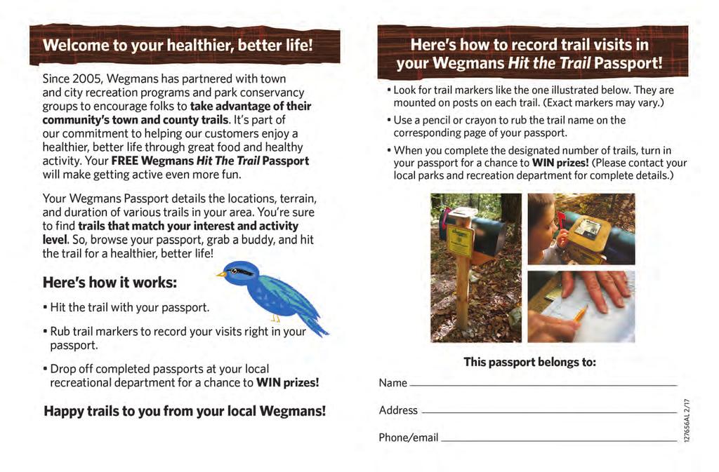
 Discovering the Trails of Prince George s County Happy Trails! Since 2005, Wegmans has been partnering with town and city recreation programs and park conservancy groups to encourage folks to get moving
Mountain Biking and Off Road Trails in Warren County, New York
 Mountain Biking and Off Road Trails in Warren County, New York Warren County Safe and Quality Bicycling Organization 96 Country Club Road Queensbury, NY 12804 www.bikewarrenco.org Warren County Safe and
Acquisition in fee simple of approximately one-half acre of property on the shore of Spring Lake to expand the Lakeside Beach Park.
 Lakeside Beach TF00-136 $122,550.00 in fee simple of approximately one-half acre of property on the shore of Spring Lake to exp the Lakeside Beach. 2000 River Ravines TF00-150 $910,000.00 in fee simple
Trail Accessibility Guide
 Trail Accessibility Guide Programs and Events The s will make every effort, with two weeks advance notice, to provide reasonable accommodations so that people with disabilities may participate in special
CAMP ROCK RANCH JACK KAVANAUGH RMABROKERS.COM
 CAMP ROCK RANCH JACK KAVANAUGH 303.909.1706 JACK@RMABROKERS.COM RMABROKERS.COM CAMP ROCK RANCH COLORADO - CLEAR CREEK COUNTY - UPPER BEAR CREEK ROAD, EVERGREEN The 162±-acre Camp Rock Ranch is surprisingly
National Recreation Trail Update Form
 National Recreation Trail Update Form Introduction Thank you for taking the time to complete this form. Your assistance will help ensure that the National Recreation Trail (NRT) database is complete and
Field Guide. Nature Nearby. Traverse City
 Field Guide Nature Nearby Traverse City FEATURED PROPERTIES 1 DEEPWATER POINT NATURAL AREA 2 HICKORY MEADOWS NATURAL AREA KALKASKA 3 MAPLE BAY NATURAL AREA E as t A rm G r a n d Tr a v er s e B ay 4 PELIZZARI
Delaware Wildlife Area
 Delaware Wildlife Area 8 miles away from Delaware 4,670 acre Wildlife Area 1) Take Rt. 36/East Williams Street eastward 2) Take left onto Rt. 42/Lake Street 3) Slight left onto Horseshoe Rd./CR. 220 4)
Crystal Lake Area Trails
 Lake Area Trails Welcome to the Lake area of the Big Snowy Mountains! This island mountain range in central Montana features peaks reaching to 8,600 feet and long, high ridges from which vistas of the
Sunrise Ranch 6890 acres, Jeff Davis County, Texas On the Fort Davis Scenic Loop
 Sunrise Ranch 6890 acres, Jeff Davis County, Texas On the Fort Davis Scenic Loop 432-386-2821 Cell 432-426-2024 Office james@kinglandwater.com King Land & Water LLC P.O. Box 109, 600 State Street, Fort
Trail Etiquette. Hours of Operation. Trail Accessibility
 Trail Guide The Elmhurst Park District, with 28 parks and over 460 acres of land, offers nearly six miles of paved or asphalt park trails and maintains an additional 3.6 miles of trails within Elmhurst.
A Vision for South Skunk River and Chichaqua Bottoms Greenbelt
 A Vision for South Skunk River and Chichaqua Bottoms Greenbelt Photo: Jim Pease Chichaqua Bottoms Booklet 7 of 8 Greater Des Moines Water Trails and Greenways 1 2016 Table of Contents Booklet 1: Water
Hiking Trail Descriptions
 Hiking Trail Descriptions For ye shall go out with joy. And be led forth with peace. The mountains and the hills shall break forth before you in singing. And all the trees of the fields shall clap their
Pinellas County Environmental Lands
 Pinellas County Environmental Lands In addition to traditional parks and recreation facilities, Pinellas County owns and manages a system of environmental lands that provides specialized resource-based
Park Activity Book. Start your adventure with Buddy Bison. Explore outdoors, the parks are yours!
 Park Activity Book Start your adventure with Buddy Bison. Explore outdoors, the parks are yours! National Park Trust www.parktrust.org Park Adventure Booklet Visit www.buddybison.org to get your own Buddy
Southern Utah University Hike Brochure
 Southern Utah University Hike Brochure Taylor Creek Trail Twenty minutes from Cedar City Red Hollow An hour and a half from Cedar City Fees: Entrance fee to Kolb Canyon Length: 5 miles round trip Length:
Parks & Recreation Areas Program
 PARKS & RECREATION Parks & Recreation Areas Program As part of its mission to conserve and protect natural resources, the Upper Big Blue Natural Resources District (NRD) has been involved in several large-scale
Ragged Mountain Natural Area. Public Planning Meeting #1 February 29 th, 2016
 Ragged Mountain Natural Area Public Planning Meeting #1 February 29 th, 2016 Planning During dam construction P&R approached by various groups asking if the rules would be changed once the dam was complete
SEP MAY 2018 ADVENTURE PASSPORT. FREE Family Outdoor Activity
 FREE Family Outdoor Activity SEP. 2017 MAY 2018 ADVENTURE PASSPORT ADVENTURE CURIOSITY EXPLORATION DISCOVERY SHARING LEARNING Otay Valley Regional Park Multi-Jurisdictional Park County of San Diego City
NORTH GEORGIA MOUNTAINS, USA. Knights Mill Farm
 NORTH GEORGIA MOUNTAINS, USA Knights Mill Farm Knights Mill Farm NORTH GEORGIA MOUNTAINS, USA Introduction: This historically significant property is perfect for development into a family compound with
Children's Discovery Trail Guide - Lost Creek
 Children's Discovery Trail Guide - Lost Creek Thank you for spending time learning and observing some of the secrets of Red Rock Canyon Conservation Area has to offer. Feel free to talk to a ranger if
West Trails Trek Guide. Chief Pontiac Trail Credential Hikes
 West Trails Trek Guide Kensington Start Edition Chief Pontiac Trail Credential Hikes RDS.WTW.110609 WP# Dist. Accum. Dist. Accum. Feet Miles Meters Meters 1 0 0.0 0 0 2 410 0.1 125 125 3 164 0.1 150 275
beach. Make the ford and follow the trail out to the junction with Red Creek Tr in an open grassy area.
 Description: This is a moderate to slightly strenuous 22.8 mile backpack (add 2.6 miles if you do the packless out and back to the Lion s Head) that will have you exploring nearly every thing that is The
THOMAS A. SWIFT METROPARK Introductions History Present Conditions Future Development Plans Implementation Strategies Statistics
 THOMAS A. SWIFT METROPARK Introductions History Present Conditions Future Development Plans Implementation Strategies Statistics Introduction As an open meadow park positioned along the Mahoning River,
Proposed Scotchman Peaks Wilderness Act 2016 (S.3531)
") 1 Proposed Scotchman Peaks Wilderness Act 2016 (S.3531) Frequently Asked Questions PLACE Where is the area that would be designated as Wilderness? The lands outlined in S.3531 lie within Idaho along its
1 Proposed Scotchman Peaks Wilderness Act 2016 (S.3531) Frequently Asked Questions PLACE Where is the area that would be designated as Wilderness? The lands outlined in S.3531 lie within Idaho along its
SDTrucksprings. Arkansas Off-roading/4x4 Guide Copyright 2015 We Specialize In:
 SDTrucksprings Arkansas Off-roading/4x4 Guide Copyright 2015 We Specialize In: Helper Springs Air Bags Leaf Springs Body Lift Kits Coil Springs Timbren Kits Hellwig Springs Lift Blocks And More! Visit
Rating: 5.0 (scale of 1-10)
") 95 Community Trail System Groundcover: 2-metre paved path, 1- metre grass buffer on either side. Location: Fort St. John Ownership: City of Fort St. John Rating: 5.0 (scale of 1-10) Strategic value: Linear
95 Community Trail System Groundcover: 2-metre paved path, 1- metre grass buffer on either side. Location: Fort St. John Ownership: City of Fort St. John Rating: 5.0 (scale of 1-10) Strategic value: Linear
Yuba Creek Natural Area Acquisition. Acme Township. Acme Township. TF Acquisition $1,576, Grand Traverse
 Yuba Creek Natural Area TF00-162 $1,576,021.00 in fee simple of 403 acres of critical wetls upl habitat with over 5,000 feet of frontage on Yuba Creek, a tributary to the east arm of Bay. 2000 Petobago
Preferred Recreation Recommendations Stemilt-Squilchuck Recreation Plan March 2018
 Preferred Recreation Recommendations Stemilt-Squilchuck Recreation Plan March 2018 Below are the recommended recreation ideas and strategies that package together the various recreation concepts compiled
Ortiz River Ranch Pagosa Springs, Colorado
 Ortiz River Ranch Pagosa Springs, Colorado This ranch provides an exceptional opportunity to own a property with frontage on the San Juan and Navajo Rivers, lush irrigated pastures, and beautiful rolling
W E L C OM E TO BAC K Y AR D N AT U R E C E N TER S SITE R E SOURCE PAC K E T S!
 LITTLE HOUSE OF GLENCOE Last updated September 7, 2011 W E L C OM E TO BAC K Y AR D N AT U R E C E N TER S SITE R E SOURCE PAC K E T S! BackYard Nature Center (BYNC) has selected and described six nature
Woodland Mountain Property
 Woodland Mountain Property So Close, Yet So Far Away Summit County, Utah 5 Acres $79,000 3616 Elmwood Street, Salt Lake City, UT 84106 801-870-1801 info@landrancher.com Welcome to Woodland Mountain Enjoy
Silver Lake Park An Environmental Jewel for the Citizens of Prince William County
 Silver Lake Park An Environmental Jewel for the Citizens of Prince William County The Prince William Park Authority Mission Statement states: The Prince William County Park Authority will create quality
ASRA 2018 Hike Schedule
 ASRA 2018 Hike Schedule Date/Day Destination Hike Info Meeting Info Leader Feb 10, Saturday Stagecoach and 9:00 at the Confluence kiosk. Manzanita trails Parking fee required. We ll hike along the trail
throu Booth Hill Green Belt
 s k r a p s l l u b m u r T Explore gh Geocaching throu Booth Hill Green Belt This was originally a concept to try and preserve some of the land in our town, without hurting the developers that are creating
Wilds. Headwaters. Lakes. Oxbows. Falls
 56 5 4 3 Wilds Headwaters Lakes Oxbows Falls 57 Zones It could be said the on-the-ground essence of this master plan appears within the next 6 pages of this report. As we learned in the preceding Cultural
System Group Meeting #1. March 2014
 System Group Meeting #1 March 2014 Meeting #1 Outcomes 1. Understand Your Role 2. List of Revisions to Existing Conditions 3. Information Sources Study Area The Purpose of Mountain Accord is to Preserve
Little Grand Canyon near Pomona, Illinois
 Little Grand Canyon near Pomona, Illinois Below: View of the trail and the terrain created using the Map My Hike app Below: Summary of the hike created using the Map My Hike app Presented by: Jennifer
2. Goals and Policies. The following are the adopted Parks and Trails Goals for Stillwater Township:
 D. PARKS AND TRAILS 1. Introduction Stillwater Township s population is relatively low, with most residents living on rural residences on large lots. The need for active park space has been minimal in
Best Hikes on Orcas Island
 Published on San Juan Islands Washington Visitors Bureau Orcas Island Lopez Island Friday Harbor San Juan Island (https://www.visitsanjuans.com) Best Hikes on Orcas Island The Emerald Isle offers big trees,
Maya s Creek Crossing Hwy 17 N acres $185,000 Fort Davis, Texas
 Maya s Creek Crossing Hwy 17 N 14.98 acres $185,000 Fort Davis, Texas James King, Agent Office 432-426-2024 Cell 432-386-2821 James@KingLandWater.com King Land & Water LLC P.O. Box 109, 600 State Street,
Cuyahoga Valley National Park Ohio
 Cuyahoga Valley National Park Ohio Brandywine Falls The Ledges The Beaver Marsh Temperate Deciduous Forest How To Get There... Located between Cleveland & Akron, Ohio Cuyahoga Valley National Park can
APPENDIX 5: JUNEAU NORDIC SKI CLUB MEMO
 APPENDIX 5: JUNEAU NORDIC SKI CLUB MEMO To all participants in the McDowell Eaglecrest nordic long-range planning meeting: It was good to meet with all of you last month and talk about our vision for the
CELEBRATE WEST GREENWICH GEOCACHING THROUGHOUT WEST GREENWICH
 CELEBRATE WEST GREENWICH GEOCACHING THROUGHOUT WEST GREENWICH The West Greenwich Land Trust (WGLT) is sponsoring Celebrate West Greenwich, an event designed to celebrate the beauty and history of scenic
BRYCE CANYON COUNTRY Boulder Mountain Scenic backways itinerary
 BRYCE CANYON COUNTRY Boulder Mountain Scenic backways itinerary Boulder Mountain Area The high plateaus of the Aquarius Plateau (Boulder Mountain), are heavily forested and covered in countless winding
The striking colours of the setting sun reflecting on the waters is how Crimson Lake received its name. Crimson Lake Provincial Park is a meeting
 The striking colours of the setting sun reflecting on the waters is how Crimson Lake received its name. Crimson Lake Provincial Park is a meeting place of foothills forests in the west, bog and muskeg
GATEWAY PHASE 2. U.S. Forest Service and the Mount Shasta Trails Association
 GATEWAY PHASE 2 U.S. Forest Service and the Mount Shasta Trails Association PROJECT DEVELOPMENT Brief history - Gateway Phase 1 - IMBA conceptual plan - BikeShasta: concert series - USFS & MSTA partnered
S H A W A N G U N K R I D G E T R A I L
 214 Shawangunk Ridge Trail The Shawangunk Ridge Trail was originally conceived as a relocation of the Long Path from Harriman State Park to Minnewaska State Park. Now part of the Long Path system, the
The following criteria were used to identify Benchmark Areas:
 7.0 BENCHMARK AREAS The Churn Creek Protected Area offers a significant opportunity to learn more about how grassland ecosystems function. One of the key tools that will be used to monitor larger grassland
The Quest begins Welcome to Frederick County s Docs in the Park Quest and the Wegmans Passport to Family Wellness. This booklet provides an opportunit
 The Quest begins Welcome to Frederick County s Docs in the Park Quest and the Wegmans Passport to Family Wellness. This booklet provides an opportunity to experience nature, the outdoors and be active
City of Keller Parks and Facilities Inventory
 City of Keller Parks and Facilities Inventory April 2013 1. BEAR CREEK PARK 44 ACRES 1 Basketball Court with 2 goals 4 Drinking Fountains 1 Large Pavilion with 4 picnic tables, electricity and fireplace
PROPOSED PARK ALTERNATIVES
 8 Chimne y Rock State Park M a ster Pl an 2011 PROPOSED PARK ALTERNATIVES Introduction Three different park development concepts were prepared and presented to the citizens of North Carolina through a
Black Hill Regional Park, Little Seneca Lake
 Black Hill Regional Park, ittle Seneca ake ittle Seneca ake, in Black Hill Regional Park, is a reservoir created after a previous drought struck the Washington area. The park is under Maryland-National
CHAPTER 5. Chapter 5 Recreation Element
 CHAPTER 5 Recreation Element Chapter 5 Recreation Element The Recreation Element of the Meyers Area Plan is a supplement to the Recreation Element of the TRPA Regional Plan and the El Dorado County General
Hit the Trails. First Day Hikes. Membership. trailworks.org
 Hit the Trails First Day Hikes Membership trailworks.org Over 30 people took part in our Wayne County First Day Hikes, ringing in the New Year at one of three locations: Casey Park, Black Brook Park, and
3.0 EXISTING PARK & RECREATION SPACE
 3.0 EXISTING PARK & RECREATION SPACE TOWN PARK & RECREATION SPACE An inventory of current parks and recreation area in the Town of Cedarburg is shown in Table 3. These areas total roughly 381.89 acres.
Conservation Area Management Statement
 Conservation Area Management Statement Miller Creek Wildlife Area Resolution #: Approval: Issue Date: Date of Last Revision: Table of Contents 1. Purpose....... 1 2. Property Description...... 1 2.1. Legal
NATIONAL ATV / UTV JAMBOREE RIDES
 NATIONAL ATV / UTV JAMBOREE RIDES Note: Rides range from Beginner to Advanced and will last from 2 to 3 hours or an entire day of riding. 1. DESERT RIDE (CLEAR LAKE BIRD REFUGE & LACE CURTAINS/LAVA TUBES)
Brinker Creek Ranch. Colorado - Routt County - Yampa
 Located at the base of the Flattops Range in the Steamboat/Vail corridor, Brinker Creek Ranch consists of 1,451 acres ideally suited for high country grazing and native grass hay production. Traditionally
Non-motorized Trail Plan & Proposal. August 8, 2014
 Town of Star Valley Ranch, Wyoming and the Star Valley Ranch Association in partnership with the USDA Forest Service, Bridger-Teton National Forest, Greys River Ranger District Non-motorized Trail Plan
Vienna. Getting There
 Vienna Like its famous and older German namesake, but on a smaller scale, Vienna, Virginia has a charm to it. Becoming increasingly more cosmopolitan, foreign restaurants, bagle and coffee shops line Maple
C E N T R A L C A T S K I L L S
 120 C E N T R A L C A T S K I L L S Central Catskills Once out of the southern parts of the Catskills, the Long Path enters the more well traveled and civilized regions. The trail joins the Devil s Path,
Understanding user expectations And planning for long term sustainability 1
 Understanding user expectations And planning for long term sustainability 1 What is a natural surface trail? It can be as simple has a mineral soil, mulched or graveled pathway, or as developed as elevated
TENNESSEE MOUNTAIN LIVING
 NOVEMBER 2016 Featuring Jasper Highlands TNLand.com END of the YEAR December 26th to Land Sale December 31st See back cover for more info... TENNESSEE MOUNTAIN LIVING JASPER HIGHLANDS - TENNESSEE'S MOST
155 acres on Tyaughton Lake 900 feet of Pristine Waterfront Private & Secluded Property
 155 acres on Tyaughton Lake 900 feet of Pristine Waterfront Private & Secluded Property 946 Tyaughton Lake Road Gold Bridge BC V0K1P0 900 ft of waterfront with 155 acres of south facing easy access. This
Chapter 9 Recreation
 Chapter 9 Chapter 9 1.0 INTRODUCTION The Town of Littleton is within one of New England s most important recreation areas. More than three million people live within 100 miles of the area. Local residents
This Passport: Revised November 28, 2017, EAM # Discover Wayne County Trails
 This Passport: Revised November 28, 2017, EAM #161924 Discover Wayne County Trails Wayne County invites you to explore and experience our region s diverse outdoor adventures! Here s your opportunity to
Welcome to North Harpersfield NY Pg 1. General Information Directions Map of Property.Lodging.Area Attractions. General Information
 Welcome to North Harpersfield NY Pg 1 General Information Directions Map of Property.Lodging.Area Attractions General Information Welcome to North Harpersfield. George Rand and Pamela Ryder invite Fyke
FINAL TESTIMONY 1 COMMITTEE ON RESOURCES UNITED STATES HOUSE OF REPRESENTATIVES. July 13, 2005 CONCERNING. Motorized Recreational Use of Federal Lands
 FINAL TESTIMONY 1 STATEMENT OF DALE BOSWORTH CHIEF Of the FOREST SERVICE UNITED STATES DEPARTMENT OF AGRICULTURE Before the SUBCOMMITTEE ON FORESTS AND FOREST HEALTH And the SUBCOMMITTEE ON NATIONAL PARKS,
Friends of Webster Trails
 Friends of Webster Trails FWT Newsletter Fall 2016 Yellow Trail at Four Mile Creek Preserve is Open Bridge Project Leader and Eagle Scout Taran Bauer Cutting the Yellow Trail Ribbon (H. Von Gehlen photo)
Trail Beginning Elevation: 7553 ft The Poison Creek Trailhead is located at the end of National Forest Road 646E (NF-646E).
.") West Mountain Trails Poison Creek Trail #134 Length: 2.9 miles (4.7 km) Difficulty Horseback: A good trail for the first time west mountain rider, some steep sections Hiking: Most Difficult USGS Maps:
West Mountain Trails Poison Creek Trail #134 Length: 2.9 miles (4.7 km) Difficulty Horseback: A good trail for the first time west mountain rider, some steep sections Hiking: Most Difficult USGS Maps:
Weston County, Wyoming
 The Sweet 200-Acre Property Weston County, Wyoming A unique opportunity to own a little piece of the old West, where one can experience unparalleled scenery, adventure and history walk in the footsteps