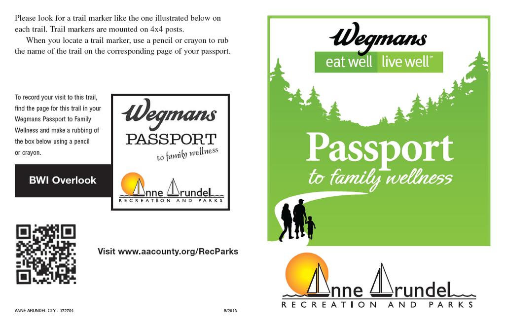
Walking Tips. Locations. Good luck on your journey to better health! Earleigh Heights Ranger Station
|
|
|
- Jessie Barker
- 6 years ago
- Views:
Transcription
1
2
3
4 Walking Tips Dress in Layers The weather and even your own body temperature can fluctuate as you walk or hike. Layering allows you to comfortably add or remove clothing as needed during your activity. Stay Hydrated If you plan to be active for an hour or less, plain water is typically the best option to keep you hydrated. If your activity will last for more than 1 hour (or the outside temperature is high) a sports drink, juice or milk provide important nutrients and electrolytes to prevent dehydration. Pack a Snack Keeping a healthy snack on hand is a good idea just in case your walk goes a little longer than planned. Snacks that travel well include an apple, banana, granola bar or a small snack bag filled with nuts, trail mix or pretzels. Wear Sunscreen Anytime you are out in the sun no matter what time of year it is, it is important to protect your skin by wearing sunscreen. Bring a Buddy Having someone to walk with makes the journey safer and more enjoyable. Good luck on your journey to better health! 68 Locations Earleigh Heights Ranger Station 51 West Earleigh Heights Rd, Severna Park Hours: Monday - Sunday, 8:00am - 4:00pm Jug Bay Wetlands Sanctuary 1361 Wrighton Rd, Lothian Trails are located in the Glendening Nature Preserve Hours: Monday - Sunday, 9:00am - 5:00pm. No entrance fee. All Parks listed below are open 7:00am Dusk. Closed Thanksgiving Day and Christmas Day. Regional Parks have a $6 daily entrance fee. Annual passes for all Regional Parks are available at Park Visitor Centers for $40. Downs Park 8311 John Downs Loop, Pasadena Closed Tuesday Fort Smallwood Park 9500 Fort Smallwood Rd, Pasadena Closed Wednesday Kinder Farms Park 1001 Kinder Farm Park Rd, Millersville Closed Tuesday Quiet Waters Park 600 Quiet Waters Park Rd, Annapolis Closed Tuesday 3
5


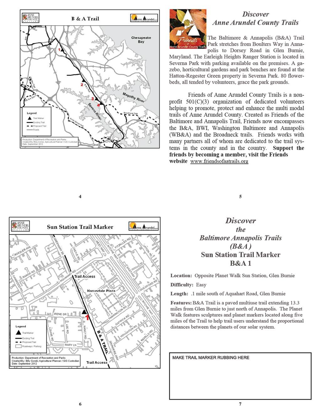
6 B&A Trail Earleigh Heights Ranger Station B&A 2 Location: Earleigh Heights Ranger Station Difficulty: Easy Length: South side of Earleigh Heights Road, Severna Park Features: Earleigh Heights was a rural stop on the Baltimore and Annapolis Short Line Railroad. The general store and post office, which also sold railroad tickets, today serves as a ranger station for the B&A Trail. Local truck farms shipped canned and fresh produce by rail to Baltimore from this location. 8 9 B&A Trail Round Bay Station B&A 3 Location: Round Bay Station, Severna Park Difficulty: Easy Length:.6 mile south of Evergreen Road, Severna Park Features: In 1885, the Baltimore and Annapolis Short Line Railroad purchased 210 acres on the Severn River at Round Bay to serve as a seasonal resort which would increase passenger traffic on the line. A half-mile spur brought crowds from Baltimore to the hotel, pavilion and other attractions
7


8 BWI Trail BWI Linthicum Station Trail Marker BWI 1 Location: Linthicum Station, Linthicum Difficulty: Easy Length: South side of W. Maple Road at BWI Trail spur Features: Linthicum Station, across W. Maple Road, was the junction where WB&A railroad routes to Washington, DC and Annapolis diverged. Today s BWI Trail spur follows the high speed Baltimore-Washington mainline as far as Andover Road, while the MTA Light Rail follows the Baltimore and Annapolis route BWI Trail BWI Overlook BWI 2 Location: Claudia Woods Memorial, Linthicum Difficulty: Moderate Length:.5 miles west of intersection of Andover Road and Hammonds Ferry Road, Linthicum Features: Outstanding location to overlook the operations of the entire Baltimore Washington International Thurgood Marshall Airport. Benches and picnic tables make this an attractive rest stop on the 12.5 mile BWI Trail which encircles the airport
9


10 WB&A Trail Little Patuxent River Bridge WB&A 2 Location: WB&A Trail Little Patuxent River Bridge, Odenton Difficulty: Easy Length:.3 miles south of intersection of WB&A Trail and Strawberry Lake Way Features: This nearly 200 foot long bridge provides wonderful vistas upstream and downstream of protected natural areas which flank the WB&A Trail on what was, until 1935, a high speed electric railway extending from Baltimore to Washington DC. Francis Station was formerly located.1 miles north of the bridge Discover Downs Park in Pasadena Situated on the Chesapeake Bay, Downs Park offers a variety of natural and recreational activities. There are more than five miles of paved and natural trails, a children s playground, 4 handball courts, 2 ball fields and 3 basketball courts. The park property has a rich history which has been preserved by the Downs Park Historical Society. The Friends of Downs Park supports many programs and projects in the park. Through their volunteers, fundraising and advocacy efforts the Friends of Downs Park is a non-profit (501c3) organization whose prime purpose is the support, enhancement and improvement of the park. For more information about the Friends of Downs Park or to become a member contact Downs Park at


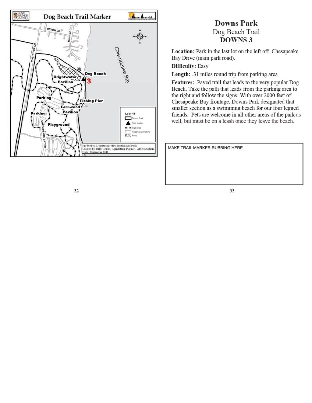
11 Downs Park Locust Cove Trail DOWNS 1 Location: After entering the West side of the park, take a right on Locust Cove Rd. Park in the last lot on the left Difficulty: Easy Length:.41 miles round trip from parking area. Features: Follow the path to the left from the parking lot. Where trail intersects, take another left. Level, paved trail that winds through a forest of mature hardwood and coniferous trees, and leads to the mouth of Locust Cove. This tidal area is a haven for wading birds. The tributary leads first to Bodkin Creek and then on to the Chesapeake Bay Downs Park South Overlook Trail DOWNS 2 Location: Park in main lot near Information Center. Difficulty: Easy Length:.25 miles round trip from parking area. Features: Paved, level trail that leads to expansive views of the Chesapeake Bay. The handicap accessible, shaded pavilion offers seating and bay breezes in a picturesque setting. Use the viewfinder for a closer look at the Ospreys that nest from mid March through early September
12
13 Discover Fort Smallwood Park in Pasadena Battery Hartshorne FSP 1 Location: Park in the lot near the battery. Difficulty: Easy Length: 1/16 mile round trip from parking area Features: Battery Hartshorne dates from 1896 and is the crowning landmark of Fort Smallwood Park. It was constructed with Portland cement, sand and gravel. The battery was created as part of a network of five artillery forts in response to the Spanish American War. It once provided protection to the City of Baltimore from incoming naval threats and now silently overlooks the Patapsco River, a reminder of its place in history Fort Smallwood Park Bill Burton Fishing Pier FSP 2 Location: Park in the lot near the old concession building. Difficulty: Easy Length:.45 of a mile round trip from the parking area to the end of the pier. Features: Named in memory of famed local fisherman and writer Bill Burton, this 380 foot pier sits on Rock Creek. The pier provides excellent opportunities for fishing, crabbing and sightseeing. The waters around the pier also provide habitat for Rockfish, White Perch and Blue Crabs to breed and grow. From the pier s end one can see the Francis Scott Key Bridge as well as the ships that pass as they head to port
14
15 Jug Bay Glendening Nature Preserve Cliff Trail Jug Bay 2 Location: North region of sanctuary Difficulty: Medium, small hills, surfaces vary. No motorized vehicles allowed. Length: 0.6 miles. Features: The trail begins at the parking lot on Wrighton Rd. Cliff Trail runs along the west edge of the Preserve, atop the Bluff above the Patuxent wetlands. Good views, especially in winter, of the broad marshes and river Jug Bay Glendening Nature Preserve Sand Barrens Jug Bay 3 Location: Use Cliff trail until it hooks back up with Red Oak and take the trail up into the Barrens. Difficulty: Medium, small hills, surfaces vary. No motorized vehicles allowed. Length: 1.4 miles from parking lot. Features: The trails begin at the parking lot on Wrighton Rd. At the north end of the Red Oak trail, the trail drops down to a low area that was a former gravel pit, now filled with Virginia Pine and Opuntia cactus. We call this area the Sand Barrens. A picnic table is located here
16
17
18
19
20
21
BOOK 2. Discover Wayne County Trails. Trail Works, Inc. is a volunteer group dedicated to trail development and use.
 Trail Works, Inc. is a volunteer group dedicated to trail development and use. Your membership in Trail Works insures that healthy programs like this continue to thrive. Join today at www.trailworks.org
Discovering the Trails of Henrietta, NY
 This Passport: Revised June 8, 2017, EAM #161919 The Town of Henrietta is fortunate to have many wonderful trails to explore. We hope you will enjoy and protect our environment. Always be safe and please
The Quest begins Welcome to Frederick County s Docs in the Park Quest and the Wegmans Passport to Family Wellness. This booklet provides an opportunit
 The Quest begins Welcome to Frederick County s Docs in the Park Quest and the Wegmans Passport to Family Wellness. This booklet provides an opportunity to experience nature, the outdoors and be active
This Passport: Revised October 20, 2017, EAM # Discovering the Trails of Webster, NY
 This Passport: Revised October 20, 2017, EAM #161923 Discovering the Trails of Webster, NY The Town of Webster invites you to explore and experience our diverse outdoor adventures! Here s your opportunity
A Publication of Friends of Sleeping Bear Dunes
 A Publication of Friends of Sleeping Bear Dunes 2014, Friends of Sleeping Bear Dunes, P.O. Box 545, Empire, MI 49630 www.friendsofsleepingbear.org info@friendsofsleepingbear.org Learn more about the Friends
PASSPORT. Discovering the Trails of Webster, NY
 PASSPORT to family wellness Discovering the Trails of Webster, NY Join the Friends of Webster Trails, Webster Health and Education Network, The Town of Webster and Wegmans to get moving more and enjoy
MARYLAND RV PARKS & CAMPGROUNDS RECOMMENDED BY THE NRVOA
 2019 MARYLAND RV PARKS & CAMPGROUNDS RECOMMENDED BY THE NRVOA Maryland Maryland, one of the original 13 states of the USA, was founded by Lord Baltimore in 1634. Its Atlantic Plain, divided by Chesapeake
This Passport: Revised March 20, 2017, EAM # Discover the Trails of Perinton, NY
 This Passport: Revised March 20, 2017, EAM #161921 Discover the Trails of Perinton, NY The Town of Perinton invites you to explore and experience our diverse outdoor adventures! Here s your opportunity
Baltimore County Nature Quest NEW TRAILS 2014
 Baltimore County Nature Quest NEW TRAILS 2014 Nature Quest Park Locations Robert E. Lee Park Cromwell Valley Park Agricultural Ctr. & Farm Park Honeygo Regional Park Marshy Point Park and Nature Center
Rating: 5.0 (scale of 1-10)
") 95 Community Trail System Groundcover: 2-metre paved path, 1- metre grass buffer on either side. Location: Fort St. John Ownership: City of Fort St. John Rating: 5.0 (scale of 1-10) Strategic value: Linear
95 Community Trail System Groundcover: 2-metre paved path, 1- metre grass buffer on either side. Location: Fort St. John Ownership: City of Fort St. John Rating: 5.0 (scale of 1-10) Strategic value: Linear
This Passport: Revised October 20, 2017, EAM # Discovering the Trails of Penfield, NY
 This Passport: Revised October 20, 2017, EAM #161922 Discovering the Trails of Penfield, NY The Town of Penfield is fortunate to have a wide variety of natural resources which make for many unique and
Discovering the Trails of Prince George s County
 Discovering the Trails of Prince George s County Happy Trails! Since 2005, Wegmans has been partnering with town and city recreation programs and park conservancy groups to encourage folks to get moving
PIKESVILLE SENIOR CENTER 1301 REISTERSTOWN ROAD PIKESVILLE, MARYLAND 21208
 PIKESVILLE SENIOR CENTER 1301 REISTERSTOWN ROAD PIKESVILLE, MARYLAND 21208 EASY RIDERS SCHEDULE -2006 Contact Person: Karen Bowling (410) 887-1245 Pikesville Senior Center Staff The Pikesville Senior Center
Guide to. Suffolk. Walking. Trails. Lake Meade Park
 Walking Lake Meade Park Guide to Suffolk Trails Lake Meade Park Lonestar Lake Regional Park Walking Safety Tips Avoid walking alone on trails. Walking with friends is recommended. Tell someone where you
2018 Trip Dates Spectacle Island July 17, 18, 19 July 31, August 1, 2 August 14, 15, 16 August 21, 22, 23 August 28, 29, 30
 Dear Youth Program Partner: June 2018 2018 Trip Dates Spectacle Island July 17, 18, 19 July 31, August 1, 2 August 14, 15, 16 August 21, 22, 23 August 28, 29, 30 Island Highlights 5 miles of trails Lifeguarded
Mazatzal Wilderness Trail Maintenance and Exploration
 Mazatzal Wilderness Trail Maintenance and Exploration March 15-19 (Wednesday - Sunday) Difficulty: Beginner Camping: Car Camping Mileage: Wednesday ~4 miles Thursday ~4-6 miles Friday ~4-6 miles Saturday
WATER PETALUMA TRAIL WATER WAYS PROJECT PORTFOLIO. petalumawaterways.org OVERVIEW
 WATER TRAIL PROJECT PORTFOLIO OVERVIEW Thirteen miles upstream of San Pablo Bay, Petaluma is the northern point on the San Francisco Bay Water Trail, a network of access points throughout the region. Most
KETTLE CREEK CONSERVATION AUTHORITY TRAIL GUIDE.
 KETTLE CREEK CONSERVATION AUTHORITY TRAIL GUIDE www.kettlecreekconservation.on.ca EXPLORE OUR TRAILS HIKE OUR TRAILS Kettle Creek Conservation Authority (KCCA) proudly supports and promotes an active lifestyle
Stephens State Park Trails
 TRAILS OF ALLAMUCHY MOUNTAIN & STEPHENS STATE PARKS Allamuchy Mountain and Stephens State Parks contain 28 marked trails providing access to diverse landscapes for walking, hiking, biking, bird-watching,
PIKESVILLE SENIOR CENTER 1301 REISTERSTOWN ROAD PIKESVILLE, MARYLAND EASY RIDERS SCHEDULE -2009
 PIKESVILLE SENIOR CENTER 1301 REISTERSTOWN ROAD PIKESVILLE, MARYLAND 21208 EASY RIDERS SCHEDULE -2009 Contact Person: Karen Bowling (410) 887-1245 Pikesville Senior Center Staff The Pikesville Senior Center
Phone Listing. Camping at NAS Patuxent River. Eligible Patrons. Reservations
 Camping at NAS Patuxent River A wide variety of recreational programs and facilities await you and your family at NAS Patuxent River, located approximately 65 miles south of Washington, DC on Maryland
Lewis and Clark Recreation Area
 Lewis and Clark Recreation Area Bicycle/Pedestrian Trail Also part of the Pierson Ranch Recreation Area trail Type of trail: Walking, biking and rollerblading Trail surface: Asphalt Rated: Mostly flat.
Hiking. Lesson 4.1. Fitness. Hiking
 Lesson 4.1 By Carone Fitness If you enjoy walking, you will probably enjoy hiking. The main difference between hiking and fitness walking is the change in terrain. is typically done in a forest, wilderness,
Hikes Away. Staged activity badge leader s notes. scouts.org.uk cotswoldoutdoor.com. In partnership with
 Hikes Away Staged activity badge leader s notes In partnership with scouts.org.uk The hikes away staged activity badge is a fantastic opportunity to equip beaver scouts with the knowledge and experience
throu Booth Hill Green Belt
 s k r a p s l l u b m u r T Explore gh Geocaching throu Booth Hill Green Belt This was originally a concept to try and preserve some of the land in our town, without hurting the developers that are creating
Aloha to Parents and Participants
 Aloha to Parents and Participants August 10-15, 2018 ISLE Project Expedition Overview WHEN: August 10-15, 2018 WHERE: Big Island, Hawai I Volcanoes National Park Kilauea Camp - A family based camp facility
beach. Make the ford and follow the trail out to the junction with Red Creek Tr in an open grassy area.
 Description: This is a moderate to slightly strenuous 22.8 mile backpack (add 2.6 miles if you do the packless out and back to the Lion s Head) that will have you exploring nearly every thing that is The
Little Grand Canyon near Pomona, Illinois
 Little Grand Canyon near Pomona, Illinois Below: View of the trail and the terrain created using the Map My Hike app Below: Summary of the hike created using the Map My Hike app Presented by: Jennifer
First Day Hikes. January 1, 2012
 First Day Hikes January 1, 2012 All hikes are different in length and difficulty. Please read the descriptions below and check out our website at www.southcarolinaparks.com for more information. Charles
7. Plan Implementation
 7. Plan Implementation 7.1 Implementation Timeline This section includes a list of achievable park and recreation actions. In the Implementation Action Matrix that follows, the implementation actions have
In partnership with. scouts.org.uk cotswoldoutdoor.com
 y a w A Hikes s e t o n s r e d a e l ge d a b y t i v i t c a d e Stag In partnership with scouts.org.uk The hikes away staged activity badge is a fantastic opportunity to equip cubs with the knowledge
Camping (Primitive) Camping (RV) Electrical Potable Water Grill Established Fire Pit Picnic Table
 Camping (RV) Electrical Potable Water Grill Established Fire Pit Picnic Table") Alden - 9th Road River Mile 777 Map: 38.20833, -98.32031 Managing Agency: Kansas Department of Wildlife, Parks & Tourism Nearest Community: Alden, Rice County Kansas Developed Amenities Provided Parking
Alden - 9th Road River Mile 777 Map: 38.20833, -98.32031 Managing Agency: Kansas Department of Wildlife, Parks & Tourism Nearest Community: Alden, Rice County Kansas Developed Amenities Provided Parking
Priority Trail Projects
 R I V E R P Priority Projects 2018 System Area-wide Projects 3-A: Addressing System for Emergency Responce 3-B: Anacostia Tributary System - Wayfinding Signage 3-D: Develop deploy pilot trail ranger program
City of Keller Parks and Facilities Inventory
 City of Keller Parks and Facilities Inventory April 2013 1. BEAR CREEK PARK 44 ACRES 1 Basketball Court with 2 goals 4 Drinking Fountains 1 Large Pavilion with 4 picnic tables, electricity and fireplace
SEP MAY 2018 ADVENTURE PASSPORT. FREE Family Outdoor Activity
 FREE Family Outdoor Activity SEP. 2017 MAY 2018 ADVENTURE PASSPORT ADVENTURE CURIOSITY EXPLORATION DISCOVERY SHARING LEARNING Otay Valley Regional Park Multi-Jurisdictional Park County of San Diego City
proof Northwest District
 1 Northwest District The Northwest Florida Water Management District is the most rural of all five water management districts. From just east of Tallahassee west to the Florida/Alabama line, and from the
Pinellas County Environmental Lands
 Pinellas County Environmental Lands In addition to traditional parks and recreation facilities, Pinellas County owns and manages a system of environmental lands that provides specialized resource-based
Walking is great exercise for the entire family. Take part in area walks that earn money for various causes:
 Get Active! Take a Walk As a physical activity, walking is hard to beat. It s free. It requires no special skills. Most people of any age can do it. It s an activity a family can easily do together. But
Clearwater Lake Provincial Park. Draft Management Plan
 Clearwater Lake Provincial Park Draft Management Plan Clearwater Lake Provincial Park Draft Management Plan Table of Contents 1. Introduction... 3 2. Park History... 4 3. Park Attributes... 4 3.1 Location/Access...4
APPENDIX 19-II. Ontario Trail Network Trailheads EAST-WEST TIE TRANSMISSION PROJECT AMENDED ENVIRONMENTAL ASSESSMENT REPORT
 EAST-WEST TIE TRANSMISSION PROJECT AMENDED ENVIRONMENTAL ASSESSMENT REPORT APPENDIX 19-II Ontario Network heads Report. 1536607/2000/2219 Ontario Network heads in the n-commercial Land and Resource Use
The beautiful Chesapeake Bay, with its
 15 Harbor View Circle Colonial Beach, VA 22443 Ranger Station: (804) 224-8164 General Delivery, Colonial Beach, VA 22443. The beautiful Chesapeake Bay, with its many historic towns, is at your doorstep
INFO FOR GROUP LEADERS
 INFO FOR GROUP LEADERS COMMUNICATE EARLY & OFTEN: Let us know ahead of time if your group size has changed or the ages within your group have changed. Also, let us know in advance if your group has any
Silver Lake Park An Environmental Jewel for the Citizens of Prince William County
 Silver Lake Park An Environmental Jewel for the Citizens of Prince William County The Prince William Park Authority Mission Statement states: The Prince William County Park Authority will create quality
Tiger Mountain State Forest:
 98 60 hikes within 60 miles: SEATTLE 20 Tiger Mountain State Forest: West Tiger Mountain Three Loop i KEY AT-A-GLANCE INFORMATION Length: 5.1 miles round-trip Configuration: Loop Difficulty: Moderate difficult
Calvert Regional Park - Tari Moore Recreational Trail. Calvert Regional Park - Woodland Trail. miles from Rising Sun
 Calvert Regional Park - Tari Moore Recreational Trail 304 Brick Meeting House Road, North East, MD 21901 5.2 about 1.1 mile Paved parking lot, plentiful Easy, paved path with slight incline. Easy, paved
A Publication of Friends of Sleeping Bear Dunes
 2019, Friends of Sleeping Bear Dunes, P.O. Box 545, Empire, MI 49630 www.friendsofsleepingbear.org info@friendsofsleepingbear.org Learn more about the Friends of Sleeping Bear Dunes, our mission, projects,
BEAVER LAKE ACCESS AREA SUMMARY 2017 Edition
 BEAVER LAKE ACCESS AREA SUMMARY 2017 Edition DEVELOPED BY THE BEAVER LAKE PROPERTY and SAFETY COMMITTEE 2 October 2017 1 NOTICE: This document supersedes and nullifies all previous versions of Beaver Lake
Hiking Trail Descriptions
 Hiking Trail Descriptions For ye shall go out with joy. And be led forth with peace. The mountains and the hills shall break forth before you in singing. And all the trees of the fields shall clap their
Welcome! Good luck to you on your adventures! Do you enjoy the outdoors? Do you and your family visit parks and use trails?
 Welcome! Do you enjoy the outdoors? Do you and your family visit parks and use trails? What can you do to promote stewardship of our streams and other natural areas? Would you like to be a Junior Ranger?
Explore your Town With The Kingston Area Trail Passport
 Explore your Town With The Kingston Area Trail Passport Don t forget to stop at the children's room in the library for your prize when you collect 5 Passport Stamps! For more natural resource related information,
Field Guide. Nature Nearby. Traverse City
 Field Guide Nature Nearby Traverse City FEATURED PROPERTIES 1 DEEPWATER POINT NATURAL AREA 2 HICKORY MEADOWS NATURAL AREA KALKASKA 3 MAPLE BAY NATURAL AREA E as t A rm G r a n d Tr a v er s e B ay 4 PELIZZARI
Summary of Recreation Sites Development Name:
 Development Name: Eau Pleine Site Number: 1 Owner: WVIC Eau Pleine Tailwater Boat Launch Lanes 1 Concrete plank landing, access to Eau Pleine tailwater & Lake DuBay. (45 planks long, 62.5') Picnic Tables
SUMMER CAMP BEST ADVENTURES EVER! YMCA CAMP ZEHNDER. Imagine, Discover and Experience Your
 YMCA CAMP ZEHNDER SUMMER CAMP Imagine, Discover and Experience Your BEST ADVENTURES EVER! SAVE 10% when you register for 6 or more camp weeks by APRIL 27, 2019. June 17 - August 30, 2019 2019 WEEKLY FEES
City of Oak Harbor Parks & Descriptions
 City of Oak Harbor Parks & Descriptions North West Section Koetje Park - NE 7 th Avenue (3.5 acres) Neighborhood and Community Park with playgrounds on one tot lot, one soccer/practice field, picnic tables,
To Wellness. To Wellness PASSPORT PASSPORT. Partners. Partners. Ashland County Health & Human Services 630 Sanborn Avenue, Ashland, WI
 Partners Ashland County Health & Human Services 630 Sanborn Avenue, Ashland, WI Ashland Bretting Center 320 4th Avenue W., Ashland, WI PASSPORT Bayfield County Health Department 117 E. 6th Street, Washburn,
PIONEER PARK. City of Des Peres Parks Master Plan. SWT Design 46 INTRODUCTION
 PIONEER PARK INTRODUCTION Pioneer Park is a 7 acre neighborhood park located east of Interstate 270 and south of Manchester Road along Tallie Road. The park is situated in a residential neighborhood with
Beaver Creek State Park
 GENERAL INFORMATION Name of Park/Forest/Facility: Beaver Creek State Park County: Columbiana (St. Clair Township) Address: 12816 Sprucevale Road (ie County Rd 428) (street #, city) East Liverpool, Ohio
Courtesy of. Upon The Mikâna Miigwetch
 Courtesy of Upon The Mikâna Miigwetch Welcome to the Skywalk Trail at Calabogie Peaks Resort Rooted in the natural and cultural history of our beautiful area, you are about to experience the highest hiking
Park Activity Book. Start your adventure with Buddy Bison. Explore outdoors, the parks are yours!
 Park Activity Book Start your adventure with Buddy Bison. Explore outdoors, the parks are yours! National Park Trust www.parktrust.org Park Adventure Booklet Visit www.buddybison.org to get your own Buddy
Field Trips General Information
 Field Trips General Information Individuals planning to participate in a field trip are encouraged to contact the trip leader in advance so the leader knows who is planning to come. Please do not call
City of Haslett. City of East Lansing. City of East Lansing
 Central Park North (Nancy L. Moore Park) Lake Park North Expansion White Park Expansion #2 White Park Expansion #1 County East East Haslett East East TF87-212 Acquisition $90,000.00 Park. TF08-138 Acquisition
West Orange Trail. Clean, Green, Fun!
 West Orange Trail Clean, Green, Fun! The West Orange Trail - when completed - will be a 36-mile, multipurpose recreational greenway containing a 14-foot wide paved surface to be enjoyed by walkers, joggers,
Matthiessen State Park Dells Area Hike
 90 Easy Hikes Close to Home At the south end of the hike, you ll climb on top of a mound left over from a former coal-mining operation in the park. Not far from Goose Lake Prairie, the town of Morris hosts
Family Hiking Day on the Appalachian Trail
 Family Hiking Day on the Appalachian Trail September 30, 2017 Guided Hikes and Trail Celebrations In celebration of National Public Lands Day, September 30th is Family Hiking Day on the Appalachian Trail!
Best Hikes on Orcas Island
 Published on San Juan Islands Washington Visitors Bureau Orcas Island Lopez Island Friday Harbor San Juan Island (https://www.visitsanjuans.com) Best Hikes on Orcas Island The Emerald Isle offers big trees,
Rail Trail Walking Challenge!
 Included with these routes is the Municipality of the District of Lunenburg s trail brochure. This map gives a rough estimate of the locations of our 6 rail trails, all managed by volunteer associations!
Share the wonders of the great outdoors with family and friends and get to know your region up close and personal.
 The Adventure Begins Baltimore County invites you to explore and experience our region s diverse outdoor adventures with Nature Quest! Here s your opportunity to discover the beauty and solitude of nature,
UNF Wildlife Sanctuary. Eco Camp 2017
 UNF Wildlife Sanctuary (904) 620-5952 rectrail@unf.edu 1 UNF Drive Building 54 Jacksonville, Fl 32224 Eco Camp 2017 Parent Packet and Information Hello Eco Campers and Parents! You are about to experience
M E S T I Z O C U R T I S P A R K
 ARAPAHOE CONNECTION TO BUS ROUTE AT ND AND LAWRENCE, FUTURE LIGHT RAIL STATION LEGEND SOCIAL TRAIL FLAGSTONE PAVING TO RESTORE/MAINTAIN CONCRETE PAVING DIAGONAL CURVILINEAR SOCIAL ROUTE IS OUT OF HISTORIC
2009 RIVER TOWN OF THE YEAR AWARD APPLICATION Supplemental Material Images
 2009 RIVER TOWN OF THE YEAR AWARD APPLICATION Supplemental Material Images Our History The earliest record of settlement along the river is in 1854; one of the earliest in Carroll County. About this time
in the St. Croix Valley
 in the Parks Your Guide to in the St. Croix Valley Our parks and trails are fun places to PowerUp! Explore the amazing, family-friendly parks and trails, right here in the St. Croix River Valley. Use this
THURSDAY 9 - THORNTON STREET CIRCUIT
 FEBRUARY THURSDAY 1 st 9 am - THORNTON STREET CIRCUIT Walk beside the Kangaroo Point Cliffs and continue through South Bank returning along the top of the cliffs. Meet Thornton Street Ferry Terminal UBD
Chapter eight. Parks and Recreation. Introduction. Crystal Lake Park District
 Chapter eight Parks and Recreation Introduction One of the indicators of quality of life in a city is the parks and recreation system. The City of Crystal Lake is fortunate to have an excellent parks and
Trail Guide To The Body 4th Edition File Type
 We have made it easy for you to find a PDF Ebooks without any digging. And by having access to our ebooks online or by storing it on your computer, you have convenient answers with trail guide to the body
GIFFORD PINCHOT NATIONAL FOREST
 GIFFORD PINCHOT NATIONAL FOREST 9341 Wright Meadow 93 Spencer Meadow Spencer Butte 4247' 30 30A 19 24 80 31C Lewis River Lower Falls 5 Quartz Creek 90 Taidnapam Falls Upper Falls 31 Spencer Peak 3861'
HISTORIC AMERICAN ENGINEERING RECORD COVE CREEK SPILLWAY BRIDGE. HAER No. AR-83
 HISTORIC AMERICAN ENGINEERING RECORD COVE CREEK SPILLWAY BRIDGE LOCATION: Spanning Cove Creek Spillway at State Highway 309 (formerly Paris-Mt. Magazine Road), Corley vicinity, Logan County, Arkansas UTM:
Crystal Lake Area Trails
 Lake Area Trails Welcome to the Lake area of the Big Snowy Mountains! This island mountain range in central Montana features peaks reaching to 8,600 feet and long, high ridges from which vistas of the
Schoolcraft Township is located in northeast Houghton County. A portion of the township borders Keweenaw County and Lake Superior.
 COMMUNITY DESCRIPTION Schoolcraft Township is located in northeast Houghton County. A portion of the township borders Keweenaw County and Lake Superior. The township is largely rural but has one main population
Segment 2: La Crescent to Miller s Corner
 goal of the USFWS refuges is to conserve, protect and enhance fish, wildlife and plants and their habitats for the continuing benefit of the American people. Refuge lands are used largely for fishing,
September Ride Schedule
 September Ride Schedule Please note that the times specified for each ride are the ride start times. You should arrive at least 15 minutes prior to the ride start time to sign in and prepare for the ride.
GREENBELT-BWI THURGOOD MARSHALL AIRPORT EXPRESS LINE ROUTE B30
 MARYLAND GREENBELT-BWI THURGOOD MARSHALL AIRPORT EXPRESS LINE ROUTE B30 BUDGET Cost neutral Option 1 Serve Arundel Mills Mall PROPOSED CHANGE Add service to Arundel Mills Mall on all trips. The time between
for lease annapolis towne centre Office/medical/retail 1910 Towne Centre Boulevard annapolis, maryland Visit us at:
 for lease annapolis towne centre Office/medical/retail 1910 Towne Centre Boulevard annapolis, maryland 21401 available Up to 5,652 sf rental rate $37.50/sf Plus utilities and janitorial website www.officesatatc.com
VOLUME II APPENDIX F DETAILED PHYSICAL DESCRIPTION OF PROJECT RESERVOIRS AND LANDS
 VOLUME II APPENDIX F DETAILED PHYSICAL DESCRIPTION OF PROJECT RESERVOIRS AND LANDS THE CENTRAL NEBRASKA PUBLIC POWER AND IRRIGATION DISTRICT FERC PROJECT NO. 1417 PHYSICAL DESCRIPTION OF PROJECT LANDS
HOW TO SURVIVE WHEN LOST IN THE DESERT
 HOW TO SURVIVE WHEN LOST IN THE DESERT Do not panic, especially if people know where you are and when you are scheduled to return. If you have a vehicle, stay with it do not wander! If you are on foot,
4.0 FACILITIES INVENTORY
 4.0 FACILITIES INVENTORY 4.1 PARK LEVEL OF SERVICE STANDARDS (LOS) Based on current City of Longview Parks and Recreation Level of Service (LOS) Standards (Figure G), the City currently has a deficiency
Non-motorized Trail Plan & Proposal. August 8, 2014
 Town of Star Valley Ranch, Wyoming and the Star Valley Ranch Association in partnership with the USDA Forest Service, Bridger-Teton National Forest, Greys River Ranger District Non-motorized Trail Plan
MONTGOMERY TOWNSHIP OPEN SPACE & PATHWAYS COMMITTEE
 MONTGOMERY TOWNSHIP OPEN SPACE & PATHWAYS COMMITTEE Meetings: 2 nd Wednesday of each month @ 6:30 PM in the Municipal Building Questions? Call the Open Space Coordinator, Lauren Wasilauski, at (908) 359-8211
Walk-On Waterfront Executive Home Qualicum Beach, BC
 Walk-On Waterfront Executive Home Qualicum Beach, BC Jamie Zroback jamie@landquest.com 1 (604) 483-1605 Jason Zroback jason@landquest.com 1 (604) 414-5577 Marketing British Columbia to the World The Source
(/ 12 (/ 18 (/ 18 (/ 12 (/ 51 (/ 14 Æ%106 Æ% 106 Æ% 213 Æ% 104 Æ% 89 Æ% 26 Æ% 73 Æ% 59 Æ% 138 Æ% 92 Æ% 26 Æ% 67 Æ% 11 Æ% 11 Æ% 11. Æÿ H Æÿ Z.
 WAUKESHA Existing Ice Age Trail, subject to change as it evolves toward completion Glacial Drumlin Rail-Trail 94 Ice Age Trail Rock, Walworth and Jefferson Counties Other Trail Unofficial Connecting Route
NORTH HEMPSTEAD BEACH PARK MASTER PLAN
 NORTH HEMPSTEAD BEACH PARK MASTER PLAN COMMUNITY DESIGN CHARRETTE Supervisor Judi Bosworth Viviana L. Russell Peter J. Zuckerman Angelo P. Ferrara Anna M. Kaplan Lee R. Seeman Dina M. De Giorgio VISIONING
Where the Sidewalk [Literally] Ends
![Where the Sidewalk [Literally] Ends](/thumbs/74/71371935.jpg "Where the Sidewalk [Literally] Ends") Where the Sidewalk [Literally] Ends by Edie Creter May 1, 2017, another perfect biking day. In the spring of 2013 I wrote a pictorial Breeze article (Where the Sidewalk Begins... ) after my first visit
Where the Sidewalk [Literally] Ends by Edie Creter May 1, 2017, another perfect biking day. In the spring of 2013 I wrote a pictorial Breeze article (Where the Sidewalk Begins... ) after my first visit
Sacramento Placerville Transportation Corridor Alternatives Analysis
 Sacramento Placerville Transportation Corridor Alternatives Analysis EL DORADO COUNTY TRANSPORTATION COMMISSION 1 Sacramento Placerville Transportation Corridor 2 Goal of the Project To give public officials
Sunday, June 17 at 11:00 am worship. Sunday, June 17 following 11:00 am worship. Thursday, June 21 to Friday, June 29. Sunday, June 24 5:00 7:00 pm
 Sunday, June 17 at 11:00 am worship Sunday, June 17 following 11:00 am worship Thursday, June 21 Friday, June 29 Sunday, June 24 5:00 7:00 pm Sunday, July 1 2:00 4:00 pm WoodsWork Commissioning Sanctuary,
Cincinnati Nature Center s
 120 60 hikes within 60 miles: cincinnati 24 Cincinnati Nature Center s Rowe Woods i KEY AT-A-GLANCE INFORMATION Length: 8.9 miles Configuration: Loop Difficulty: Difficult Scenery: Forest, ponds, prairie,
Municipal Park Descriptions: 1. Bear Hollow Park 4100 Bear Hollow Park Court, Murrysville, PA acres
 MUNICIPAL PARK DESCRIPTIONS Murrysville has a wide variety of parks and recreational facilities including sports fields, neighborhood parks, community parks, a Community Center, and extensive natural areas
YOU are Invited!! Who? Yes, You! Parents, Parishioners, Friends, Family, and all who want to help support our school.
 YOU are Invited!! Who? Yes, You! Parents, Parishioners, Friends, Family, and all who want to help support our school. What is the Spring Fling? We have live and silent auctions, raffles, dancing, music,
U.S. National Forest Campground Guide
 U.S. National Forest Campground Guide Southwestern Region Arizona, New Mexico, Oklahoma and Texas National Forests and Grasslands in the Southwestern Region NF = National Forest NG = National Grassland
CHAPTER 4 -- THE LAND USE PLAN: DESCRIPTIONS AND POLICIES FOR THIRTEEN PLANNING AREAS
 CHAPTER 4 -- THE LAND USE PLAN: DESCRIPTIONS AND POLICIES FOR THIRTEEN PLANNING AREAS SOUTH COAST CAC PLANNING AREA 4.10 NAVARRO RIVER TO MALLO PASS CREEK PLANNING AREA (Includes Greenwood/Elk) This planning
Yuba Creek Natural Area Acquisition. Acme Township. Acme Township. TF Acquisition $1,576, Grand Traverse
 Yuba Creek Natural Area TF00-162 $1,576,021.00 in fee simple of 403 acres of critical wetls upl habitat with over 5,000 feet of frontage on Yuba Creek, a tributary to the east arm of Bay. 2000 Petobago
December 2015 Eco-Buggy Tour in Lyonia Preserve from 9:00-11:00 a.m. December 5.
 December 2015 Eco-Buggy Tour in Lyonia Preserve from 9:00-11:00 a.m. December 5. Nature lovers can get a different perspective of Lyonia Preserve during this fun program. Participants will board the county