Vienna. Getting There
|
|
|
- Linda O’Connor’
- 6 years ago
- Views:
Transcription
1 Vienna Like its famous and older German namesake, but on a smaller scale, Vienna, Virginia has a charm to it. Becoming increasingly more cosmopolitan, foreign restaurants, bagle and coffee shops line Maple Avenue, the main street through the town. Of course, good-old American restaurants are healthily represented too. The town s is a nice size. It s not too big to have a personable Forth of July celebration on school grounds. unning east-west, the Washington and Old Dominion Trail (W&OD), runs through the center of town. At Maple Avenue, the distance east to osslyn on the trail is 11.4 miles. Going the other direction Purcellville is 33.2 miles away. Nearby however, is one of the nicer sections of the whole W&OD Trail. For the almost three miles from Ayr Hill Ave. to Hunter Mill d. the trail is uninterrupted by auto traffic as it parallels Piney Branch, a tributary to Difficult un. The park land also runs wider through this area than is in most of the rest of the places that the W&OD Trail passes through. Getting There From the Capital Beltway, I-495 Take Exit 9, for I-66, west. After 2.5 miles, exit onto Nutley Street, headed toward Vienna. Go 1.2 miles, then turn right on Maple Ave. You ll cross the W&OD Trail after 0.75 miles. Another tenth of a mile ahead, turn right on the aptly named Park St. A quarter mile ahead, turn right, into the Vienna Community Center and park next to the W&OD Trail. Area outes Clarks Crossing (6.7 or 8.4 miles, VI, or IX) Go right to the nicest of the nearby trails by heading west on the W&OD Trail. The most popular thing to do is to go out and back to Hunter Mill d. After getting out of Vienna, the trail gradually descends while paralleling the Piney Branch. At Difficulty un, almost to Hunter Mill d, the trail starts climbing again gradually. That s it for the obstacles. There s just nice park land to watch as you go. The route is measured on the paved trail, however beginning after leaving Vienna, a gravel horse trail parallels very closely and can be used for variety. The horse trail is more hilly but is a little quieter. Cyclists and in-line skaters tend to get-up goods speeds on the paved downhill sloping W&OD Trail. An option for those looking for something with much more variety, is to turn off the W&OD Trail at Clarks Crossing d. By going through suburban streets for a way you can make a lollipop route to and around Meadowlark Gardens. The loop is hilly however. Part of the loop is on street sidewalks, and part is on a wide gravel trail. This loop circles the gardens. To really see them however, you must pay an entrance fee. Vienna (11.3 miles, X) With Vienna being on the W&OD Trail, and it being close enough to the Accotink Stream Valley and City of Fairfax Connector Trails you can make a grand loop if you re in shape for the distance. First head east on the W&OD. There s a slight uphill grade and the paved W&OD is partly shady at first. After two miles and reaching Gallows d. turn right, passing Dunn Loring
2 Park, crossing I-66, and passing the Dunn Loring metro station. The next two miles (the worst is really one mile long) through Merrifield is the least palatable part of the route. The industrially zoned section still has sidewalks to get through on, but the close-by traffic including bridges over Lee Hwy, te. 29, and Arlington Blvd., te. 50, can start you wondering what you re doing there. The bright side of reaching rock-bottom aesthetically is that things only get better. Turning off Gallows d. at Woodburn d. go another mile on much nicer suburban streets. Upon entering Eakin Park, one and a half miles of quiet woods that gradually climb to Arlington Blvd, te 50, are your reward.. The next half mile isn t very nice, being on the shoulder of the road, but soon you can cross over and start up the City of Fairfax Connector Trail. Paved at first, the trail rises, then falls to Lee Hwy, te 29. Cross over it, then continue the trail climbing again through the woods on a partially paved trail toward the Vienna Metro station. End the connector trail in Nottoway Park, then use roads and sidewalks getting back to the community center. Nearby and Connecting Zones Eakin Community Park Idlwood Park eston What to do Afterward Food and Drink Nizam s estaurant - Turkish food Marco Polo s estaurant, Inc Aarathi Indian Cuisine Bertucci s Brick Oven Pizzeria Paya-Thai Phillips Seafood Grill Narita Japanese estaurant Entertainment and Edification Hunter House at Nottoway Park - built in / Meadowlark Gardens egional Park Wolf Trap Barns - indoor music and performance arts Wolf Trap Farm Park - outdoor music and performance arts
3 Clarks Crossing Distance: ating: 6.7 or 8.4 miles VI or IX; paved trail on the shorter route; roads and hill on the longer one; sunny 6.7 Mile oute 0.0 from the community center parking, head west on the W&OD 0.1 trail X on L to school 0.25 Maple Ave (TL) 0.4 Vienna station (water) 0.95 Mile Marker 12.5 and leave Vienna <* 2.0 Clarks Crossing d & park on 2.3 wooden bridge over Piney Branch 3.0 end of wooden bridge over Difficult U >* un 3.35 Hunter Mill d 3.75 end of wooden bridge over Difficult un 4.4 wooden bridge over Piney Branch 4.75 Clarks Crossing d & park on L 5.75 Mile Marker 12.5 and enter Vienna 6.3 Vienna station (water) 6.5 Maple Ave (TL) 6.7 community center parking *8.4 Mile oute 2.0 Clarks Crossing d & park on L 2.05 Batten Hollow d 2.65 trail X on L 2.7 Abbey Oak Dr 3.0 Meadowlark d 3.4 trail X on ; paved at first then bluestone 3.5 cross creek /L 4.35 Perimeter Trail (gravel) 4.6 Meadowlark Gardens entrance 4.75 gate on L 5.15 gate on to gardens 5.3 gate on trail B 5.35 end of trail; bear on Meadowlark d (unmarked) L 5.4 Abbey Oak Dr 5.65 Batten Hollow d 5.75 trail X on L S 3.65 trail ends; S on Asoleado La 6.35 at T; Clarks Crossing d L 3.85 Lozano Dr; up steep hill 4.3 Beulah d; (use shoulder) L 6.4 on W&OD Trail at end of road (pickup cues at mile 5.75 on 6.7 mile route)

4 Carks Crossing
5 Vienna Distance: ating: 11.3 miles X; paved and unpaved trails, sidewalks; some rolling hills L 0.0 from the community center parking lot; head east on W&OD Trail 0.05 Park St 0.45 trail X on to Talahi d 0.95 trail X on to Adahi d 1.7 trail X on to Jackson Pkwy 9.5 Virginia Center Blvd 9.75 CFCT head at end of Vaden Dr S trail ends at parking lot onto park road toward exit (water) 2.05 Gallows d 2.3 trail X on into Dunn Loring Park 2.4 trail X on into Dunn Loring Park 2.6 begin bridge over I Dunn Loring Metro station on 3.25 Lee Hwy, te begin bridge over Arl Blvd, te Fairfax Hospital on 4.65 Woodburn d 5.05 Tobin d asphalt trail along Courthouse d XS10.65 at Nutley St Locust St S 11.5 at Center St; trail goes along the side of the school W&OD Trail parking at Vienna Community Center L/ 5.95 into Eakin Community Park L/ 6.0 gravel trail on L; take fork 6.1 Accotink Stream Valley Trail 6.4 Prosperity Ave 7.0 Barkley Dr L 7.65 Arl Blvd, te 50; use sidewalk, then shoulder (!) 8.1 cross Arl Blvd at Pickett d to City of Fairfax Connector Trail (CFCT) 8.3 road X (unmarked) 8.35 trail X (paved) /L 8.6 at Circle Woods Dr to cross Lee Hwy, te 29 /L 9.25 at Saintsbury Dr; follow CFCT along Vaden Dr; cross I-66 ahead
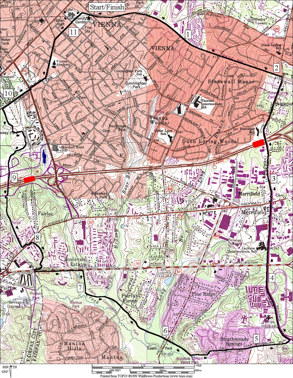
6 Vienna
Eakin Community Park. Getting There
 Eakin Community Park Quiet woods along the Accotink Creek are the hallmark of Eakin Community Park. Actually a string of smaller parks, Eakin is made-up of Mantua Park, Kern Drive Park, Eakin Park, Woodburn
Trailside Park, Herndon
 Trailside Park, Herndon Herndon is not the little rail stop it used to be. Like many of the smaller towns around Washington, D.C. Herndon has grown and changed. It even installed it s own little beltway,
Jackson Miles Abbott Wetlands Refuge/Fort Belvoir
 Jackson Miles Abbott Wetlands efuge/fort Belvoir Over the course of millions of years the Potomac iver has gradually shifted its course and sediments have filled-in its old river bed. The main river once
Columbia, Maryland - Village of Owen Brown
 Columbia, Maryland - Village of Owen Brown From the Village of Owen Brown, good trails stretch to other neighboring Columbia villages. Mostly following stream valleys, the trails go to and from schools
Trailside Park, Ashburn
 Trailside Park, Ashburn For an outsider, Ashburn might seem like a follow-up act to eston. It s a large planned community built at the time, outside the known limits of civilization... Vast farm fields
Aurora Hills. Getting There
 Aurora Hills Aurora Hills is neighborhood near Crystal City and Pentagon City. Ball fields, ball courts, a very short trail, and a combination ibrary/fire Station are the central pieces of a recreation
Lake Artemesia. Getting There
 Lake Artemesia Lake Artemesia is a man-made lake and park located near the confluence of the Indian un, and Paint Branch creeks. A flat 1.3 mile paved path around the lake is popular with walkers, runners
Black Hill Regional Park, Little Seneca Lake
 Black Hill Regional Park, ittle Seneca ake ittle Seneca ake, in Black Hill Regional Park, is a reservoir created after a previous drought struck the Washington area. The park is under Maryland-National
Leesburg. Getting There
 eesburg eesburg embodies the historic nature of oudoun County better than does Ashburn. As of 1999, it is on the boundary line of suburbia and the country. It s not only the largest town in oudoun County,
Difficult Run Stream Valley Park
 Difficult Run Stream Valley Park The more intense mountain bikers have known about for Difficult Run for some time. Equestrians have known it longer. Eight miles of unpaved trail, the Rails to River Trail
Rock Creek Park, MD - Lake Needwood
 ock Creek Park, MD - Lake Needwood Lake Needwood, is a reservoir located at the end of the north end of the ock Creek hiker-biker trail. At the other end, ock Creek empties into the Potomac iver near Thompson
Foxhill Park, Bowie, Maryland
 Foxhill Park, Bowie, Maryland The approximately 50,000 residents of the city of Bowie, Maryland are proud of the trails that link the city. Many trails exist and many are planned. Bowie is a changing city.
Great Falls National Park, Virginia
 Great Falls National Park, Virginia Despite having grown-up in the area, I had not seen Great Falls until I was near an adult. I used to think places like Great Falls only existed someplace else that you
Airport Terminal Services Inc 1 Aviation Cir, DC 20001
 Airport Terminal Services Inc 1 Aviation Cir, DC 20001 Continue to George Washington Memorial Pkwy 1. Head southwest 2. Turn right toward George Washington Memorial Pkwy 3. Turn right toward George Washington
Skiing and Snowshoes on Un-groomed Fernan Saddle Terrain
 Skiing and Snowshoes on Un-groomed Fernan Saddle Terrain Three ski or snowshoe routes are available from the Fernan Saddle Parking Lot which either do not cover routes ordinarily groomed for snow machine
TETRA TECH AMT 1515 Wilson Blvd. Suite 1100 Arlington, VA USA (703)
") DIRECTIONS TO HEADQUARTERS Included in this Guide: Directions to Tetra Tech 1 AMT Headquarters Parking Information 1 FAA National 2 Headquarter Locations Shuttle Schedule 2 Service to FAA Buildings Closest
DIRECTIONS TO HEADQUARTERS Included in this Guide: Directions to Tetra Tech 1 AMT Headquarters Parking Information 1 FAA National 2 Headquarter Locations Shuttle Schedule 2 Service to FAA Buildings Closest
This Passport: Revised October 20, 2017, EAM # Discovering the Trails of Webster, NY
 This Passport: Revised October 20, 2017, EAM #161923 Discovering the Trails of Webster, NY The Town of Webster invites you to explore and experience our diverse outdoor adventures! Here s your opportunity
2018 Resource & Relocation Guide
 County - Virginia 2018 Resource & Relocation Guide 1 CONTENTS Published By: In association with Sales Coordinator: Lee Crew Ad Designer: Teri Burkitt Book Designer: Asha Bohannon www.skylinepub.net 5 Welcome
Understanding Your I-66 Trip
 Understanding Your I-66 Trip DETERMINING YOUR TRIP Identify the location of your most convenient entrance and then follow the map to your exit. Pricing is tracked by four gantries along the corridor. Traffic
BRR Leg 1 (3.9 miles, Easy)
") BRR Leg 1 (3.9 miles, Easy) Min 3901 Max 4919 Ascent +21 Descent -1031 0.0 Start (Grayson Highlands State Park Visitor Center) 3.9 Grayson Highlands State Park Office & Gate, on R (EZ 1) Leg Notes: Minimal
BRR Leg 1 (3.9 miles, Easy) Min 3901 Max 4919 Ascent +21 Descent -1031 0.0 Start (Grayson Highlands State Park Visitor Center) 3.9 Grayson Highlands State Park Office & Gate, on R (EZ 1) Leg Notes: Minimal
Slad over to Pitchcombe and back
 The walk climbs up from Slad over Wickridge Hill, descends to near Pitchcombe, then climbs back over Wickridge hill and round the back of Slad. Page 1 Start Point: SO 8718 0732 The Woolpack, Slad Length:
C E N T R A L C A T S K I L L S
 120 C E N T R A L C A T S K I L L S Central Catskills Once out of the southern parts of the Catskills, the Long Path enters the more well traveled and civilized regions. The trail joins the Devil s Path,
WAGS Tournament Field Directions (October 8-10, 2016)
") WAGS Tournament Field Directions (October 8-10, 2016) Arrowbrook Park (Herndon) 2330 Centreville Rd, Herndon, VA 20171 From the Dulles Toll Road: Take the Herndon/Chantilly exit onto Centreville Road and
WAGS Tournament Field Directions (October 8-10, 2016) Arrowbrook Park (Herndon) 2330 Centreville Rd, Herndon, VA 20171 From the Dulles Toll Road: Take the Herndon/Chantilly exit onto Centreville Road and
A Publication of Friends of Sleeping Bear Dunes
 A Publication of Friends of Sleeping Bear Dunes 2014, Friends of Sleeping Bear Dunes, P.O. Box 545, Empire, MI 49630 www.friendsofsleepingbear.org info@friendsofsleepingbear.org Learn more about the Friends
Inova Fairfax Medical Campus Hotel Guide
 Extended Stay America 8281 Willow Oaks Corporate Dr. Fairfax, VA 22031 703-204-0088 Walking distance 0.5 miles https://www.extendedstayamerica.com/hotels/dc/ washington-dc/washington-dc-falls-church-merrifield
Cumberland County Hiking Marathon Trail Descriptions
 Cumberland County Hiking Marathon Trail Descriptions 8/28/2017 Welcome to the 2017 Cumberland County Hiking Marathon. As you hike these trails you will enjoy a wide variety of terrain and geographical
PASSPORT. Discovering the Trails of Webster, NY
 PASSPORT to family wellness Discovering the Trails of Webster, NY Join the Friends of Webster Trails, Webster Health and Education Network, The Town of Webster and Wegmans to get moving more and enjoy
Section 7: Pick Up Where You Left Off! S-Tree Road over the Todd Road
 2018 TRACE NOTES Helpful information for your adventure on Section 7 of the Hiker Challenge. Start Point S-Tree Rd. End Point Intersection Todd Rd. / Hale Ridge Rd. WEATHER DECISION Weather Alert!!!! Potential
CONTACT: Michelle T. Holland
 FOR IMMEDIATE RELEASE Thursday, December 7, 2017 CONTACT: Michelle T. Holland 703-586-0487 (C) Michelle.Holland@vdot.virginia.gov Jennifer McCord 571-230-2926 Jennifer.McCord@vdot.virginia.gov 66 EXPRESS
Tiger Mountain State Forest:
 98 60 hikes within 60 miles: SEATTLE 20 Tiger Mountain State Forest: West Tiger Mountain Three Loop i KEY AT-A-GLANCE INFORMATION Length: 5.1 miles round-trip Configuration: Loop Difficulty: Moderate difficult
BRR Leg 1 (4.0 miles, Easy)
") BRR Leg 1 (4.0 miles, Easy) Min 3881 Max 4948 Ascent +36 Descent -1027 0.0 Start (Grayson Highlands State Park Visitor Center) 4.0 Grayson Highlands State Park Office & Gate, on L (EZ 1) Leg Notes: Minimal
BRR Leg 1 (4.0 miles, Easy) Min 3881 Max 4948 Ascent +36 Descent -1027 0.0 Start (Grayson Highlands State Park Visitor Center) 4.0 Grayson Highlands State Park Office & Gate, on L (EZ 1) Leg Notes: Minimal
Leaden Boot Challenge ROUTE INSTRUCTIONS
 Leaden Boot Challenge ROUTE INSTRUCTIONS Section 1 Alstonefield to Ilam From the village hall car park turn R then L and pass through the village keeping to the R to enter Church Street. Pass the Church
BEGINNER. mayorsmtbchallenge.org
 mayorsmtbchallenge.org Redding s second local Mountain Bike Challenge uniting current and new bicyclists in a friendly self-competition highlighting our diverse trail system. BEGINNER N Churn Creek Greenway
43 STONE MOUNTAIN LOOP
 204 60 hikes within 60 miles: atlanta 43 STONE MOUNTAIN LOO i KEY AT-A-GLANCE INFORMATION LENGTH: 5.5 miles CONFIGURATION: Loop DIFFICULTY: Easy SCENERY: Views of Stone Mountain and Confederate Memorial;
Leaden Boot Challenge 2016 ROUTE INSTRUCTIONS
 Leaden Boot Challenge 2016 ROUTE INSTRUCTIONS Section 1 Alstonefield to Ilam (CP2) From the village hall car park turn R then L and pass through the village keeping to the R to enter Church Street. Pass
beach. Make the ford and follow the trail out to the junction with Red Creek Tr in an open grassy area.
 Description: This is a moderate to slightly strenuous 22.8 mile backpack (add 2.6 miles if you do the packless out and back to the Lion s Head) that will have you exploring nearly every thing that is The
Figure 2: Public Transit Systems Operating in Northern Virginia Operating Statistics and Performance Indicators, FY 2004
 Figure 2: Public Transit Systems Operating in Northern Virginia Operating Statistics and Performance Indicators, FY 24 Potomac and Rappahannock Transportation Commission Fairfax Connector Omni Ride Omni
Much of the information which follows is included by kind permission of the Tynedale Council (now defunct) and is based on its brochure.
 and is based on its brochure.") The Tyne Green Trail This easy going circular walk is on level ground throughout. It follows the course of the River Tyne between Hexham Bridge and the turning point just past Watersmeet. The return is
The Tyne Green Trail This easy going circular walk is on level ground throughout. It follows the course of the River Tyne between Hexham Bridge and the turning point just past Watersmeet. The return is
l McConnell Public Safety and Transportation Operations Center
 How to use this timetable Use the map to find the stops closest to where you will get on and off the bus. Select the schedule (Weekday, Surday, Sunday) for when you will travel. Along the top of the schedule,
DAY 1: Circular Quay to Greenwich Wharf
 DAY 1: Circular Quay to Greenwich Wharf Total Distance: 14km Time: Approximately 5 hours Walk Notes in Six Sections Section Name Length Time 1:1 Circular Quay to Milsons Point Station 2.5km 50mins 1:2
The TransAm Eastern Express - Westbound Map Set #23 Watkins Mill State Park, MO to Atchison, KS 66.0 Miles / Cumulative Climbing: 2,955
 The TransAm Eastern Express - Westbound Map Set #23 Watkins Mill State Park, MO to Atchison, KS 66.0 Miles / Cumulative Climbing: 2,955 PART #1 WATKINS MILL STATE PARK TO PARADISE, MO PARADISE CYCLING
Baltimore County Nature Quest NEW TRAILS 2014
 Baltimore County Nature Quest NEW TRAILS 2014 Nature Quest Park Locations Robert E. Lee Park Cromwell Valley Park Agricultural Ctr. & Farm Park Honeygo Regional Park Marshy Point Park and Nature Center
Telluride-to-Moab Alternative Singletrack Options
 Telluride-to-Moab Alternative Singletrack Options Day 1 Day 1 Alternate 1: Galloping Goose to Deep Creek. 18.4 miles, ascent 3,530ft, descent 1,388ft. This is fun, flowey, moderate to intermediate singletrack
Drive and Stop Routes
 Drive and Stop Routes Limantour Road 1 - easy and likely productive. From Bear Valley Visitor Center drive back out and turn left onto Bear Valley Rd. Turn left at Limantour Road (the first road). Drive
Leg 1 (4.0 miles, Easy)
") Leg 1 (4.0 miles, Easy) Leg Description: Steady, but controlled downhill (paved). Leg Notes: Great views of the Grayson Highlands balds and mountains. Watch for wild ponies. 0.0 Grayson Highlands State
Leg 1 (4.0 miles, Easy) Leg Description: Steady, but controlled downhill (paved). Leg Notes: Great views of the Grayson Highlands balds and mountains. Watch for wild ponies. 0.0 Grayson Highlands State
BG Peter D. Hidalgo (Retired) Internment at Arlington National Cemetery, Virginia
 Internment at Arlington National Cemetery, Virginia") BG Peter D. Hidalgo (Retired) Internment at Arlington National Cemetery, Virginia SERVICE Date: Tuesday, February 17, 2009 Time: 1100 Please arrive at Arlington National Cemetery by 10:30 and proceed to
BG Peter D. Hidalgo (Retired) Internment at Arlington National Cemetery, Virginia SERVICE Date: Tuesday, February 17, 2009 Time: 1100 Please arrive at Arlington National Cemetery by 10:30 and proceed to
Rogue Gorge (Mt. Stella) Roadless Area-- T30S R3E (primarily in portions of Sections 23, 26, 33, 34 & 35)
 Roadless Area-- T30S R3E (primarily in portions of Sections 23, 26, 33, 34 & 35)") Rogue Gorge (Mt. Stella) Roadless Area-- T30S R3E (primarily in portions of Sections 23, 26, 33, 34 & 35) Rogue River-Siskiyou National Forest--High Cascades Ranger District Upper, higher elevation trail
Rogue Gorge (Mt. Stella) Roadless Area-- T30S R3E (primarily in portions of Sections 23, 26, 33, 34 & 35) Rogue River-Siskiyou National Forest--High Cascades Ranger District Upper, higher elevation trail
This Passport: Revised October 20, 2017, EAM # Discovering the Trails of Penfield, NY
 This Passport: Revised October 20, 2017, EAM #161922 Discovering the Trails of Penfield, NY The Town of Penfield is fortunate to have a wide variety of natural resources which make for many unique and
Which was your favorite Exchange Point & why? Your Team s favorite part of the KT82?
 1 1 Which was your favorite Exchange Point & why? Your Team s favorite part of the KT82? Did any Volunteer or Security Person go above and beyond to assist your team? Any Additional Comments you wish
YOSEMITE ON HORSEBACK: THREE RIDES ALONG TIOGA ROAD Cindy Casey White Wolf Area, May Lake Loop, Ragged Peak Loop
 YOSEMITE ON HORSEBACK: THREE RIDES ALONG TIOGA ROAD Cindy Casey White Wolf Area, May Lake Loop, Ragged Peak Loop The high country along Tioga Road presents us with some of the most dramatic scenery in
Potato Chip Grinder. Sheet1
 Potato Chip Grinder MILE DIRECTIONS FOR 0 START: Albertsons 5 Woodland Pkwy San Marcos, CA. (OPEN:00:00 CLOSE:+0:00) Obtain proof of start from local business with time & date stamp. Exit parking lot toward
Cataloochee. Fishing Species Rainbow Trout and Brook Trout. Recreation
 Cataloochee River Information The Cataloochee River is located in the historic Cataloochee Valley--a relatively remote part of Smoky Mountain National Park. The campground is a secluded setting and offers
Frederick County, MD Rural Roads Tour # 3
 Frederick County, MD Rural Roads Tour # 3 Unionville Loop Tour mileage: Approx. 63 miles Driving time: about 3 ½ hours (not including stops) There are 5 separate tours of Frederick County s Rural Roads.
Lava Mountain Trail Distance: Elevation Range: Trail Type: Difficulty: Season: Driving Distance: Driving Time: USGS Maps: Pros Cons
 Lava Mountain Trail Distance: 13.4 miles (including the side trip to North Star Lake) Elevation Range: 5900'-8330' Trail Type: singletrack Difficulty: moderate Season: late June-October Driving Distance:
H U D S O N P A L I S A D E S
 14 H U D S O N P A L I S A D E S Hudson Palisades The southernmost sections of the Long Path follow the Hudson River and the Hudson Palisades north, staying close to the river and to civilization. Although
Cincinnati Nature Center s
 120 60 hikes within 60 miles: cincinnati 24 Cincinnati Nature Center s Rowe Woods i KEY AT-A-GLANCE INFORMATION Length: 8.9 miles Configuration: Loop Difficulty: Difficult Scenery: Forest, ponds, prairie,
Lost River Retreat Center 2015 Mill Gap Road Lost City, WV (304)
") Lost River Retreat Center 2015 Mill Gap Road Lost City, WV 26810 (304) 897-5935 To make a reservation contact: Hank Dunn 703-869-0376 hank@hankdunn.com The Vienna Baptist Church 541 Marshall Road, SW Vienna,
Lost River Retreat Center 2015 Mill Gap Road Lost City, WV 26810 (304) 897-5935 To make a reservation contact: Hank Dunn 703-869-0376 hank@hankdunn.com The Vienna Baptist Church 541 Marshall Road, SW Vienna,
Asheville & WNC Hikes
 Asheville & WNC Hikes Amazingly, we have 3,000+ miles of free public hiking trails near Asheville, including 1,600 miles in the Pisgah and Nantahala National Forests, 850 miles in Great Smokey Mountains
START - UPHILL BEACH. (tidal!) The West Mendip Way is route-marked with these round blue signs
 The West Mendip Way is route-marked with these round blue signs") START - UPHILL BEACH Start Times: 10:30 11:15 12:00 Please allow sufficient time to check in with the marshals Start on the beach at the high water line (tidal!) The West Mendip Way is route-marked with
START - UPHILL BEACH Start Times: 10:30 11:15 12:00 Please allow sufficient time to check in with the marshals Start on the beach at the high water line (tidal!) The West Mendip Way is route-marked with
throu Booth Hill Green Belt
 s k r a p s l l u b m u r T Explore gh Geocaching throu Booth Hill Green Belt This was originally a concept to try and preserve some of the land in our town, without hurting the developers that are creating
Abbotts Falls Walking Track
 Abbotts Falls Walking Track 3 hrs 7.3 km Circuit Hard track 329m This circuit takes you through both dry and moist forest, using a combination of walking trails and wider tracks. The side trip to the dammed
Calvert Regional Park - Tari Moore Recreational Trail. Calvert Regional Park - Woodland Trail. miles from Rising Sun
 Calvert Regional Park - Tari Moore Recreational Trail 304 Brick Meeting House Road, North East, MD 21901 5.2 about 1.1 mile Paved parking lot, plentiful Easy, paved path with slight incline. Easy, paved
Weekly East Tennessee Construction Report for May 31-June 6, 2018
 Weekly East Tennessee Construction Report for May 31-June 6, 2018 Thursday, May 31, 2018 01:30pm ANDERSON COUNTY, SR 62 between Union Valley Road and SR 162: Motorists should be alert for possible lane
Central Overland Trail Utah & Nevada Driving Guide, First Edition, 2016
 Central Overland Trail Utah & Nevada Driving Guide, First Edition, 2016 Page 51 In the third paragraph, second sentence, change 0.4 miles to 0.1 miles. In the fourth paragraph, second sentence, change
Introduction to Topographic Maps
 Introduction to Topographic Maps DIRECTIONS: Read all of the following content. READ EVERYTHING!! At the end of the packet, you will find two topographic maps. Your task is to indentify each of the elevations
Oregon Section B - Page m
 Oregon Section B - Page 1 5 35000m 5 36000m 5 37000m 5 38000m 46 57000m 46 58000m Hwy5B - Interstate Highway 5 - mi 1716.4-4271 ft RD1717 - PCT departs paved Old Highway 99 - mi 1716.8-4357 ft PL1717 -
HIKING/BIKING IN MERRITT AREA
 HIKING/BIKING IN MERRITT AREA Coquihalla Lakes: Just inside the southern boundary of BC Park's Coquihalla Summit Park, a nice little twin lakes paddle with a private campground & lodge is the Coquihalla
A retrospective look at work program counting activities since 2001 is found in Table 8, on the last page of this document. Hours of Operation
 Page 2 of 20 Background TPB staff has been managing data collection along the region s HOV facilities since the late 1990's, and documenting the results, which include counts of auto occupants, vehicles
ANV HOME TOUR COURTESY GUIDELINES. Please respect our current homeowners, and please use the following guidelines:
 ANV HOME TOUR COURTESY GUIDELINES Please respect our current homeowners, and please use the following guidelines: 1. Please do not enter the properties listed. This includes driveways and lawns. 2. Do
Guide to. Suffolk. Walking. Trails. Lake Meade Park
 Walking Lake Meade Park Guide to Suffolk Trails Lake Meade Park Lonestar Lake Regional Park Walking Safety Tips Avoid walking alone on trails. Walking with friends is recommended. Tell someone where you
COURSE DESCRIPTION AND DIRECTIONS
 COURSE DESCRIPTION AND DIRECTIONS START TO BOUNTIFUL B (MILE 0 to MILE 17.05) From the start at East Mountain Wilderness Park, go past the green metal gate of East Mountain Wilderness Park and follow the
LIHTC Properties in Virginia's 10th District (Barbara Comstock
 LIHTC Properties in Virginia's 10th District (Barbara Comstock LIHTC (1997 to - R) 2016) Source: HUD LIHTC Through 2016 nprofit CEDAR CREEK I 7601 MAIN ST MIDDLETOWN VA 22645 Insufficient Data Insufficient
Project Delays in the FY09-14 Six-Year Improvement Program
 Project Delays in the FY09-14 Six-Year Improvement Program ROUTE 58 58 Abingdon Big Stone Gap Bluefield Bristol Lebanon Marion Norton Saltville Tazewell Wise Wytheville Widening from two to four lanes
playwinterpark.com Off The Beaten Path Hikes Hiking Recommendations for the Adventurous Hiker
 playwinterpark.com Off The Beaten Path Hikes Hiking Recommendations for the Adventurous Hiker Hike: Devil s Thumb (difficult) Length: 3.93 miles one-way Elevation: Trailhead 9609 Destination 12,236 Trailhead
Great Eastern Trail Newsletter
 Great Eastern Trail Newsletter Volume 1, Number 1, January 2011 By Timothy A. Hupp Please feel free to print out or copy and distribute this newsletter Note this is the first newsletter of the Great Eastern
Hiking Las Vegas.com
 Hike: Mt. Wilson via First Creek Canyon route Trailhead: First Creek marked Distance: 10 miles up and back Elevation gain: 3,400 feet Elevation of Peak: 7,070 feet Time: 7 to 9 hours (up and back) Difficulty:
BISHOPSTONE CIRCULAR WALK
 BISHOPSTONE CIRCULAR WALK 4½ miles (7¼ km) - allow 2 hours (see maps on final pages) Introduction This walk is within the North Wessex Downs Area of Outstanding Natural Beauty and starts from the small,
Capital Beltway HOT Lanes Project
 New Travel Choices Ahead Some things can t wait for traffic Capital Beltway HOT Lanes Project Project Update August 16, 2011 Major Milestones Reached Some things can t wait for traffic Project over 75%
Pontfadog. Walk A. Walk A
 Walk A A Bird s eye view of the village 2km. (1 1 /2 miles); height gain 45m. (150ft) about 45 minutes. Six minutes walk along the main road towards Glyn Ceiriog reach a signpost to Llwynmawr. Take the
Guide for 2018 Jackson Brigade Reunion Tour Written by Nancy Jackson, Last update July 24, 2018
 Guide for 2018 Jackson Brigade Reunion Tour Written by Nancy Jackson, Last update July 24, 2018 We will start from the "Super 8 by Wyndham Weston" motel parking lot Saturday August 4, 2018. Be there by
CIEC 9 PEAKS AWARD SUPPLEMENT POSSIBLE ROUTES FOR THE 9 PEAKS AWARD TRIP
 CIEC 9 PEAKS AWARD SUPPLEMENT POSSIBLE ROUTES FOR THE 9 PEAKS AWARD TRIP As you plan your trip, be aware of 3 regulations in this wilderness: 1. Camp only in designated campsites. 2. No campfires allowed.
(/ 12 (/ 18 (/ 18 (/ 12 (/ 51 (/ 14 Æ%106 Æ% 106 Æ% 213 Æ% 104 Æ% 89 Æ% 26 Æ% 73 Æ% 59 Æ% 138 Æ% 92 Æ% 26 Æ% 67 Æ% 11 Æ% 11 Æ% 11. Æÿ H Æÿ Z.
 WAUKESHA Existing Ice Age Trail, subject to change as it evolves toward completion Glacial Drumlin Rail-Trail 94 Ice Age Trail Rock, Walworth and Jefferson Counties Other Trail Unofficial Connecting Route
Massanutten Mountain Cluster
 Massanutten Mountain Cluster Signal Knob Catback Mountain Southern Massanutten Mountain Five areas of almost 49,000 acres on the Lee Ranger District compose the Massanutten Mountain Cluster of Mountain
Piestewa Peak/Dreamy Draw Trail Guide
 Piestewa Peak/Dreamy Draw Trail Guide Trail #1A - Perl Charles Memorial Trail Length: 4.8 miles Elevation: 2,200 ft. - 1,340 ft. Difficulty: Moderate to difficult The Perl Charles trailhead is located
VDOT HOT SPOTS IN THE FREDERICKSBURG DISTRICT June 12 June 18, 2016
 RELEASE: IMMEDIATE June 10, 2016 CONTACT: Kelly Hannon 540-374-3344 (office) 540-656-0321 (cell) Kelly.Hannon@VDOT.Virginia.Gov Tina Bundy 540-899-4560 (office) 540-907-8325 (cell) Tina.Bundy@VDOT.Virginia.Gov
Transform66 Transportation Management Plan: Transit & TDM Strategies
 Transform66 Transportation Management Plan: Transit & TDM Strategies Commuter Connections Committee November 15, 2016 1 Transforming I-66 A short introduction. http://outside.transform66.org/meetings/video_recordings.asp
Discover Historic Burlington A 10-mile self-guided tour
 Discover Historic Burlington A 10-mile self-guided tour 12 Colchester Causeway 10 Leddy Park NORTH AVE. LEDDY PARK ROAD 11 Ethan Allen Park Winooski River 13 17 Ethan Allen Homestead 9 North Beach NORTH
PART #1 LaCYGNE TO GARNETT, KS
 The TransAm Eastern Express Connector - Westbound Map Set #4 LaCygne, KS to Iola, KS 58.5 Miles / Cumulative Climbing: 1,420 PART #1 LaCYGNE TO, KS CYCLING NARRATIVE: BE AWARE: There are no services in
RELEASE: IMMEDIATE September 14, 2012 CONTACT: Sandy Myers (office) STA (cell)
 STA (cell)") RELEASE: IMMEDIATE September 14, 2012 CONTACT: Sandy Myers 540-332-9201 (office) STA12-130 540-292-2500 (cell) Sandy.Myers@VDOT.Virginia.gov Marshall Barnhill 540-332-9264 (office) 540-414-5670 (cell)
RELEASE: IMMEDIATE September 14, 2012 CONTACT: Sandy Myers 540-332-9201 (office) STA12-130 540-292-2500 (cell) Sandy.Myers@VDOT.Virginia.gov Marshall Barnhill 540-332-9264 (office) 540-414-5670 (cell)
Milwaukee River (Washington County) Segment. Kewaskum. Æÿ B. Æÿ D Southern. Kewaskum. Segment.
 Segment. Kewaskum. Æÿ B. Æÿ D Southern. Kewaskum. Segment.") Ice Age Trail Washington County Washington County FOND DU LAC WASHINGTON Æ% 28 Æÿ H Milwaukee River (Washington County) Æÿ B Æÿ S State Forest Northern Kettle Moraine Æÿ H Æ% 28 Ice Age Trail Alliance
Ice Age Trail Washington County Washington County FOND DU LAC WASHINGTON Æ% 28 Æÿ H Milwaukee River (Washington County) Æÿ B Æÿ S State Forest Northern Kettle Moraine Æÿ H Æ% 28 Ice Age Trail Alliance
San Luis Obispo. Bishop Peak Felsman Loop Eagle Rock Maino Open Space Poly Canyon Poly P Other Areas
 San Luis Obispo Bishop Peak Felsman Loop Eagle Rock Maino Open Space Poly Canyon Poly P Other Areas 1 JCT. ELEV. 72 400 00 0 FELSMAN LOOP GATE LOOP RIDGE 600 FENCE JCT. ELEV. 860 1000 1200 BISHOP PEAK
Appendix 1: Phase I Strategies
 Washington Metropolitan Area Transit Authority RTSP Presentation to the Technical Advisory Group January 19, 2012 Appendix 1: Phase I Strategies Base Case Definition MWCOG 2009 Adopted CLRP (2009-2030
Marilla Reservoir to Chestnut Ridge via Marilla Trails and Bullis Hollow Trail east to west
 USGS topographic maps useful to this hike are the Bradford and Stickney 7.5 minute sectionals. These notes are designed to assist in identifying distance and location using geophysical and man-made characteristics
2014 PERFORMANCE OF HIGH-OCCUPANCY VEHICLE FACILITIES ON FREEWAYS IN THE WASHINGTON REGION
 2014 PERFORMANCE OF HIGH-OCCUPANCY VEHICLE FACILITIES ON FREEWAYS IN THE WASHINGTON REGION Travel Forecasting Subcommittee Friday, May 22, 2015 C. Patrick Zilliacus Figure 1 HOV System Overview Montgomery
INTERMEDIATE. mayorsmtbchallenge.org
 mayorsmtbchallenge.org Redding s second local Mountain Bike Challenge uniting current and new bicyclists in a friendly self-competition highlighting our diverse trail system. INTERMEDIATE Mule Ridge Cosmos
Performance Measure Summary
 Performance Measure Summary Congestion Duration = reduction in the number of hours of the day auto and transit passengers experience heavily congested travel conditions. of Delay = reduction in the number
TRANSPORTATION. Reston Market Profile
 Reston Market Profile TRANSPORTATION Fairfax County Background A recent TIME Magazine featured rapidly growing Fairfax County as one of four "megacounties" in the nation-suburban counties that have outgrown
HARDMOORS 55 RACE ROUTE 2018 HELMSLEY - GUISBOROUGH
 HARDMOORS 55 RACE ROUTE 2018 HELMSLEY - GUISBOROUGH HELMSLEY - CHECKPOINT 1 (WHITE HORSE) 1. Leave RACE START, continue ahead on road (Baxtons Sprunt) At crossroads turn right down Canons Garth eventualy
BACKROADS BICYCLE/AUTOMOBILE TOUR OF MIDDLESEX, VERMONT
 BACKROADS BICYCLE/AUTOMOBILE TOUR OF MIDDLESEX, VERMONT (created and published by the Middlesex Historical Society) Welcome to a 25-mile self-guided historical tour of the backroads of Middlesex. You may
WALDORF (METRO WASHINGTON, D.C.), MARYLAND
, MARYLAND") WALDORF (METRO WASHINGTON, D.C.), MARYLAND A GROWING DESTINATION Located in Charles County, St. Charles Towne Center serves an affluent, fast-growing market in Southern Maryland, outside of Washington
WALDORF (METRO WASHINGTON, D.C.), MARYLAND A GROWING DESTINATION Located in Charles County, St. Charles Towne Center serves an affluent, fast-growing market in Southern Maryland, outside of Washington