This Passport: Revised November 28, 2017, EAM # Discover Wayne County Trails
|
|
|
- Garey Stafford
- 5 years ago
- Views:
Transcription


1 This Passport: Revised November 28, 2017, EAM # Discover Wayne County Trails
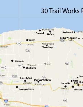
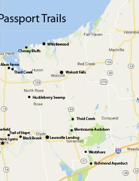
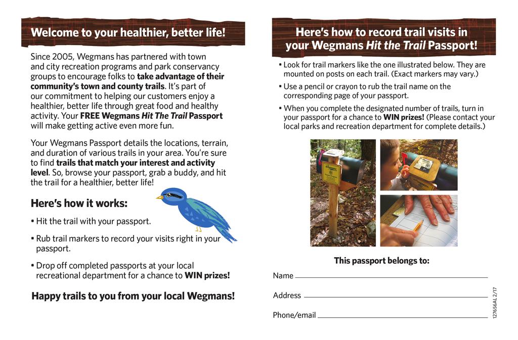
2 Wayne County invites you to explore and experience our region s diverse outdoor adventures! Here s your opportunity to discover the beauty and solitude of nature, a variety of wildlife, the magnificence of natural settings and the health benefits of being more active all in your own backyard! Share the wonders of the great outdoors with family and friends and get to know your region up close and personal. The Wayne County Wegmans Hit the Trail Passport program runs continuously. In order to enter for the chance to win a $250 Wegmans gift card, you need to complete 15 of the 30 trails in the booklet and bring it to Cornell Cooperative Extension on Rt. 88 in Newark. If you complete all 30 trails, you will have 2 entries in the drawing. The drawing will be held annually in the Fall and your entry remains in the pool. Any questions: contact us through our website Hiking tips: Please observe posted regulations on all pathways Bring a buddy or tell someone of your plans Bring bug repellent and water (stay hydrated) Wear weather appropriate clothing and footwear Bring your Wayne County Wegmans Hit the Trail Passport and a pencil or crayon for the rubbing.


 receiver or mobile device and other navigational techniques to hide and seek")
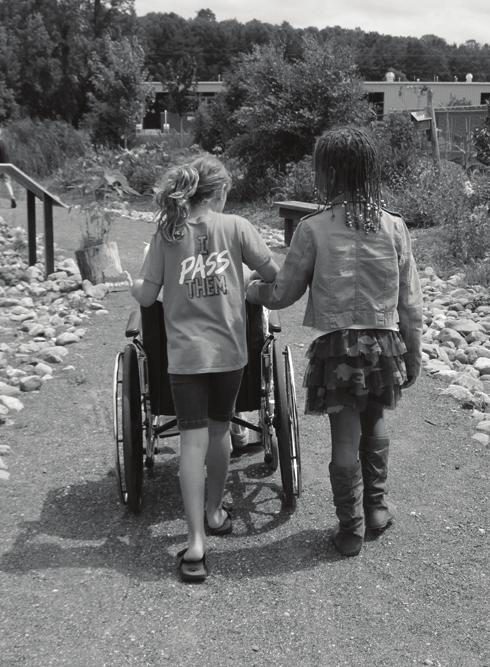
3 Forever Wild for Everyone Accessible Trails We believe that all people should have the opportunity to enjoy nature and its many benefits, regardless of their abilities. We hope to facilitate the development and/or designation of nature trails without barriers that everyone can enjoy. Geocaching is an outdoor recreational activity, in which participants use a Global Positioning System (GPS) receiver or mobile device and other navigational techniques to hide and seek containers, called "geocaches" or "caches", at specific locations marked by coordinates all over the world.
4
5
6
7
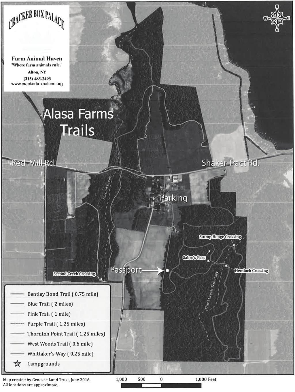
8 Alasa Farm Trails at Cracker Box Palace Farm Animal Haven Location: 6450 Shaker Road in Sodus. Parking is in the field at the junction of Shaker and Red Mills Roads (seasonal) and behind the bunkhouse at the main Farm entrance on the east side of Shaker Road Hiking Distance: 6.5 miles total Difficulty: Easy to moderate. Terrain ranges through open field edges to steep slopes and narrow trails in the woods. Second Creek crossing is not bridged and must be forded by walking in the creek on the bedrock stream-bed. Features: Hiking, skiing and equestrian use, wildlife habitat conservation, natural and agrarian areas, friendly farm animals, historic Shaker farm site. Self-guiding Farm Tour Booklets available on site. Alasa Farm is preserved in partnership with Genesee Land Trust. MAKE TRAIL RUBBING MARKER HERE
9
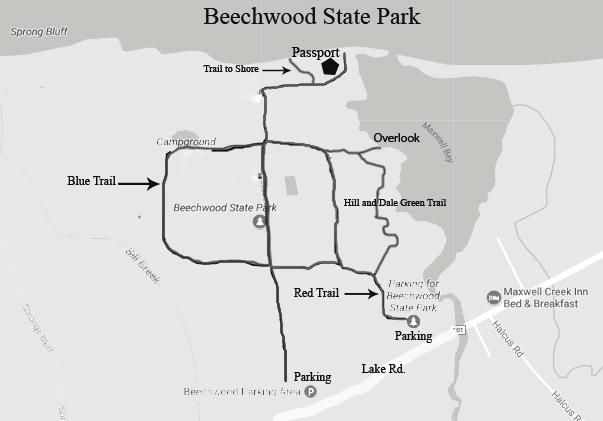
10 Beechwood State Park Location: Beechwood State Park is located in the town of Sodus on the shore of Lake Ontario. 2 miles west of Sodus Pt. (Rt. 14) and 8.5 miles east of Pultneyville. Hiking Distance: 3.1 miles of trails. Difficulty: All trails are easy to moderate. Features: Beechwood State Park offers numerous trails that wind through an old Girl Scout Camp. The trails feature an oldgrowth hardwood forest, White Pine and Larch Pine plantation, a meadow, and a young growth hardwood forest. There are many beautiful views of Lake Ontario and Maxwell Bay. Bald Eagles, Red-Tailed Hawks, and numerous species of song birds and water fowl are common sights in the park. Check in with caretaker for Carry-in/Carry-out camping. MAKE TRAIL RUBBING MARKER HERE
11
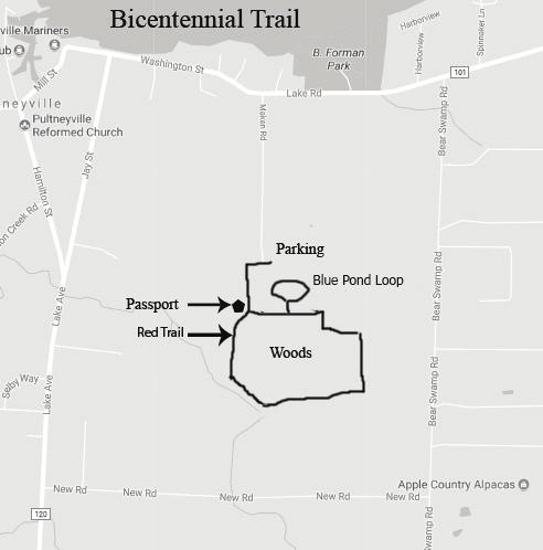
12 Bicentennial Trail Location: In Pultneyville, off Lake Rd. onto Maken Rd. Parking at the Water Treatment Facility Hiking Distance: Approximately 1.2 miles Difficulty: Gentle trail through mixed hardwood forest; some boardwalks. Accessible to walkers, bikes, equestrian. Features: Wooded area with added pond loop. MAKE TRAIL RUBBING MARKER HERE
13
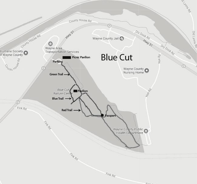
14 Blue Cut Nature Center Location: This County Park is located between the villages of Newark and Lyons south off Route 31. Hiking Distance: approx. 1.5 miles Difficulty: Moderate. There are a few steep but short hills to climb on the main loop. Features: The name Blue Cut dates back to 1853 when a cut was made through a drumlin while building the railroad. The Vernon Shale had a bluish cast when exposed. Today this nature center and wildlife refuge covers over 40 acres of open land with marsh and pond, mixed hardwoods and red pine plantation. Surface: Dirt, mowed-grass, and pine needle trails. There are 3 trails and multiple end points in the trail system. End points on the map, should be thought of as dead ends. The outer loop of the trail system, which includes sections of each trail, will bring you right back to the parking area. A new picnic pavilion has been added to the Nature Center. MAKE TRAIL RUBBING MARKER HERE
15

16 Black Brook Park on the Enlarged Erie Canal Location: West of the Village of Clyde on Old Rt. 31 Parking at Lock Berlin Park, Peters Road or Black Brook Park, off Old Rt. 31 Hiking Distance: 2.75 Miles Linear, 5.5 miles round trip. This is a designated Forever Wild for Everyone Trail for.6 miles from Gansz Rd. to the Passport Marker. Features:. A historic site of the Enlarged Erie Canal on over 20 acres. Wooded trail parallels Clinton s Ditch and the Enlarged Erie Canal, crossing old foundations and locks. This trail features Clinton s Ditch Lock 65 and Enlarged Lock 54. MAKE TRAIL RUBBING MARKER HERE
17
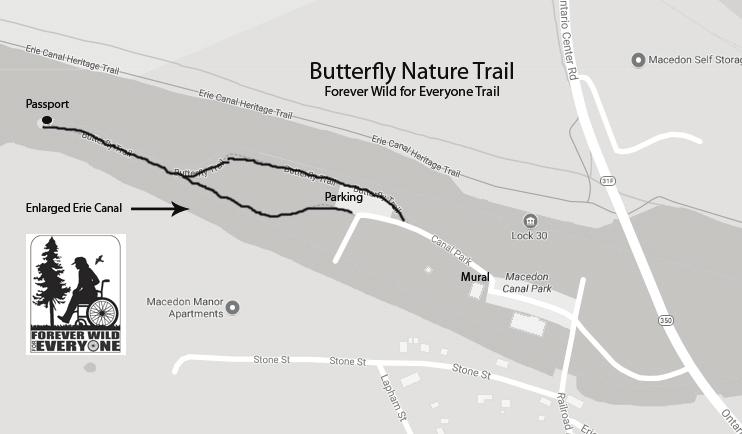
18 Butterfly Nature Trail Location: The Butterfly Nature Trail is located in the Village of Macedon at Canal Park-Lock 30 on the south side of the Erie Canal. From Route 31, head north on Route 350, take a left at the Butterfly Nature Trail sign, go past the Elmer Clark Mural Pavilion to the end of the parking lot. Park your mode of transportation and walk through the unique wooden arbor. Hiking Distance: minutes or more depending on stops to read the educational signs. ¼ mile trail. Difficulty: Easy, level, stone-dusted, accessible trail. Features: It provides a place for all people to enjoy the beauty of nature. The trail is a great educational tool for butterflies, birds and the history of the Erie Canal. From one vantage point all three eras of the canal system can be viewed. The trail is next to free picnic areas, camping and launching for boats, kayaks and canoes. The trail is a minute walk from/to the Main Street Business area with unique shops, easily accessed from the Erie Canalway National Heritage Trail Corridor. Come enjoy this hidden treasure. MAKE TRAIL RUBBING MARKER HERE
19
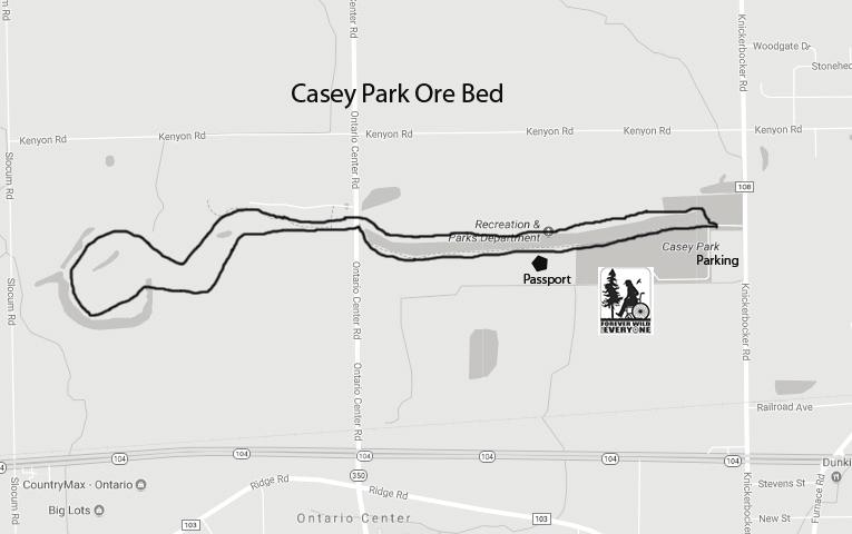
20 Casey Park Ore Beds Location: Parking is available at Casey Park off Knickerbocker Rd., north of Rt. 104 in Ontario. There is additional parking on Ontario Center Rd. near the new loop trail. Hiking Distance: 2+ miles. Hiking times will vary. An additional loop extends another 2 miles. Access is across Ontario Center Rd. Difficulty: South side of trail is wide dirt path, but north side of trail traverses a narrow ridge. Care must be taken (no bicycles). This is a designated Forever Wild For Everyone Trail on the south side. Features: The abandoned iron ore bed is a narrow waterway. Hiking along the southern shore begins at the swimming area. The wide path is packed dirt. At the west edge of the ore bed, the path narrows and climbs to return on the north shore, high on a narrow ridge. MAKE TRAIL RUBBING MARKER HERE
21
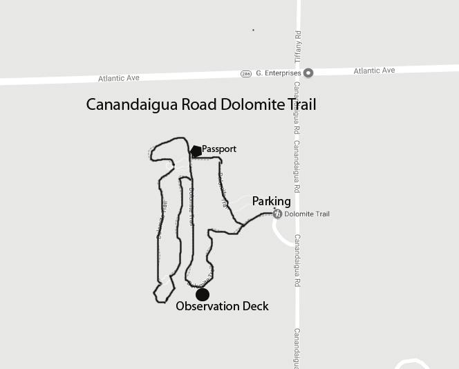
22 Canandaigua Road Dolomite Trail Walworth Location: Parking is off Canandaigua Rd. south of Atlantic Avenue and opposite the Walworth Town Barns, near Freewill Elementary School. Hiking Distance: approximately 1.0 miles Features: Trail entrance begins in parking lot by entering into the woods. Trail marker, maps and directional posts guide you along the trail through brush, pine trees, and wooded areas. Follow the trail to the marsh overlook/observation deck. Return to parking lot via winding wooded trail. A new trail spur begins directly behind map marker at the south end near the marsh. It travels along the west border of marsh then turns right (uphill) and circles back through wooded area to main trail. MAKE TRAIL RUBBING MARKER HERE
23
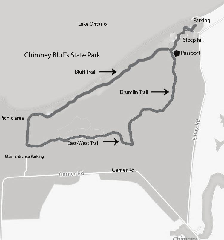
24 Chimney Bluffs State Park Location: Main parking area is off Garner Road, Town of Huron Hiking Distance: 2+ miles. Top trail is about 1 mile and continues down a steep hill to the east parking lot and beach. There is also a North/South trail call the Drumlin Hill trail that starts at the passport marker. This trail intersects with the East/West trail about a half mile from the passport. Take this trail west to go back to the main parking lot. Caution should be exercised when near the Bluff s edge. Recent erosion of lake properties have caused some trails to be re-routed Features: Land and water clash at Chimney Bluffs, sculpting the most dramatic landscape on the Lake Ontario shore. You can experience massive earthen spires from above or along the lakeshore. A wonderful place to view sunsets. MAKE TRAIL RUBBING MARKER HERE
25
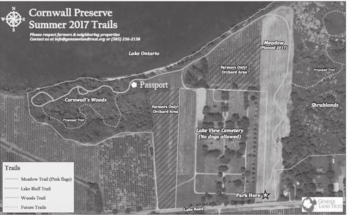
26 Cornwall Preserve Location: Located just west of the Hamlet of Pultneyville, on Lake Road. There is a small parking lot and an information kiosk. The preserve surrounds Lakeview Cemetery. Hiking Distance: Allow at least an hour. Established trails approximately 1.5 miles each way. Difficulty: The Meadow Trail and Lake Bluff Trail are rolling grassy trails through a wildflower meadow and along Lake Ontario. The Woods Trail is an enclosed trail through 13 acres of woodlands with occasional roots and stones in the trail. Features: The 74 acre Cornwall Preserve was purchased by Genesee Land Trust in This unique property encompasses 2/3 mile of natural lakefront on Lake Ontario, mature woodlands, a wildflower meadow, and important migratory bird habitat. The property surrounds the Historic Lakeview Cemetery and also includes active fruit farmland. The Preserve is open to the public dawn to dusk, every day of the week, but closed on Wednesdays for agricultural management. Contact Genesee Land Trust at (585) with questions or visit MAKE TRAIL RUBBING MARKER HERE
27
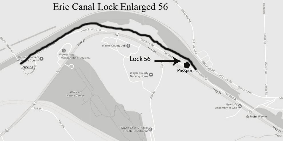
28 Enlarged Erie Canal Lock 56 Location: Parking on County House Rd. NW of Route 31 in Lyons Hiking Distance: Linear 1.44 miles with a lot of history, so hiking time will vary with interest Features: Enlarged Erie Canal Lock No. 56 (also called the Poor House Lock) is located in the Town of Lyons, Wayne County, N.Y., approximately 2.5 miles west of the village of Lyons, N.Y. It is a double-chamber lock, with the north chamber featuring a miter gate and tumble gate. The eastern end of the trail features a working dry dock, winter home to the Colonial Belle and the Tugboat Urger. MAKE TRAIL RUBBING MARKER HERE
29
30 Ganargua Creek Meadow Preserve Location: From Rte. 31 in Macedon, turn south on Rte 306 (Wayneport Road). Turn east onto Wilkinson Road. At the crest of the hill turn south onto Bunker Hill Dr. Near the end of Bunker Hill Drive there is a small parking area. Walk up the gravel road towards the water tower and an entrance kiosk will be on the left. A larger parking area is located off of Wilkinson Rd where it meets Victor Rd. Hiking Distance: West side of Ganargua Creek: approximately 1.3 miles, with various spur trails throughout the meadow. East Side: 0.76 miles Features: This Preserve, donated to Genesee Land Trust in 1996 by the Kesselring Family to honor Tim Johnson, and adjacent Wayne ARC land, is made up of an upland area of hardwoods, wildflowers and shrubs, the winding Ganargua Creek, and an open meadow where food and cover for birds and other animals is abundant. There is exceptional butterfly habitat in the meadow. Meadow is often wet. Dress for poison ivy. MAKE TRAIL RUBBING MARKER HERE

31 Historic Lyons Trail Location: Begin at Abbey Park, on Old Lyons Rd. and end at the Little League Field on Elm Street. East of Rt. 14. Hiking Distance: Approx. 1-1/2 mile. Difficulty: Easy walking paths and sidewalks. Features: Canal Locks, historic buildings/museums, parks, and murals of historic Lyons. Lyons Historic Trail Map Legend 1. Abby Park- Former site of the Lyons Aqueduct on the Erie Canal 2. Former site of the Vinegar and bed of the Enlarged Erie Canal and
32 Clinton s Ditch 3. Winston Dobbins Park and site of the Winston Dream mural Hotchkiss Peppermint Building (1839) and site of the Peppermint Mural 5. Battle Square, canal boat captains would often fight for the right to be the first through former Lock Site of current Fire house 7. Mural Canal Town (1990) on the east side of Santelli s Lumber and McDonalds 8. Lyons Post Office, inside - Mural Wall 9. Maitre D' at Trombino's /Former Park Hotel/Regent Theater/Livery10. Livery Stable (1885) 11. Wayne County Museum of History/Former Wayne County Jail (1855) 12. First Lutheran Church (1849) 13. Myron Taylor House (1840 s) 14. Wayne County Court House (1854) 15. Central Park/Fountains (1920 s)/ Bandstand (1890 s) Passport Marker 16. Lyons National Bank (1829) 17. Mural Street of Dreams (2007) Generations of Smiles mural ( Generations of Smiles Mural (2007) 19. Generations Mural (2007) Dobbins Drugs and Former Parshall House (1883) 20. The House Block Bottling Company (1893) 21. The Ohmann Theater (1915) 22. Lyons Methodist Church Clock (1850) 23. Lyons Elementary School former Union School 24. Lyons Village Hall (1851) former Fire Department Building th Century Row Building Canal Street 26. Mural Believe You Can Achieve (2008) 27. Former Trolley Station (1906) Firetruck Mural (2009) 29. Stepping Back Time Mural (2016) 30. Taylor Park 31. Site of the first settlers to Lyons near the Elm tree MAKE TRAIL RUBBING MARKER HERE
33
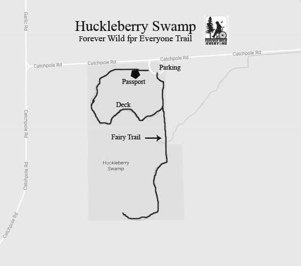
34 Huckleberry Swamp Location: Huckleberry Swamp is located outside the Town of North Rose. From Route 104, turn south on Brick Schoolhouse Road. Take Brick Schoolhouse Road until it ends at Catchpole Road then turn right. Huckleberry Swamp is just ahead on the left Hiking Distance: 1.4 mi. Note: Closed on Mondays and winters Difficulty: Easy with some boardwalks. Features: 79 acres of diverse, high quality wetlands for bird and wildlife habitat conservation. A wildlife observation deck and boardwalk meanders through a variety of wetland habitats including emergent marsh, Green Ash Wetland, and Red Maple Wetland. Huckleberry Swamp provides significant functions including storm water retention, groundwater recharge, wildlife habitat, and possibly rare plant habitat. Springtime heron rookery. A new feature at Huckleberry Swamp is the Fairy House Trail. MAKE TRAIL RUBBING MARKER HERE
35
36
37
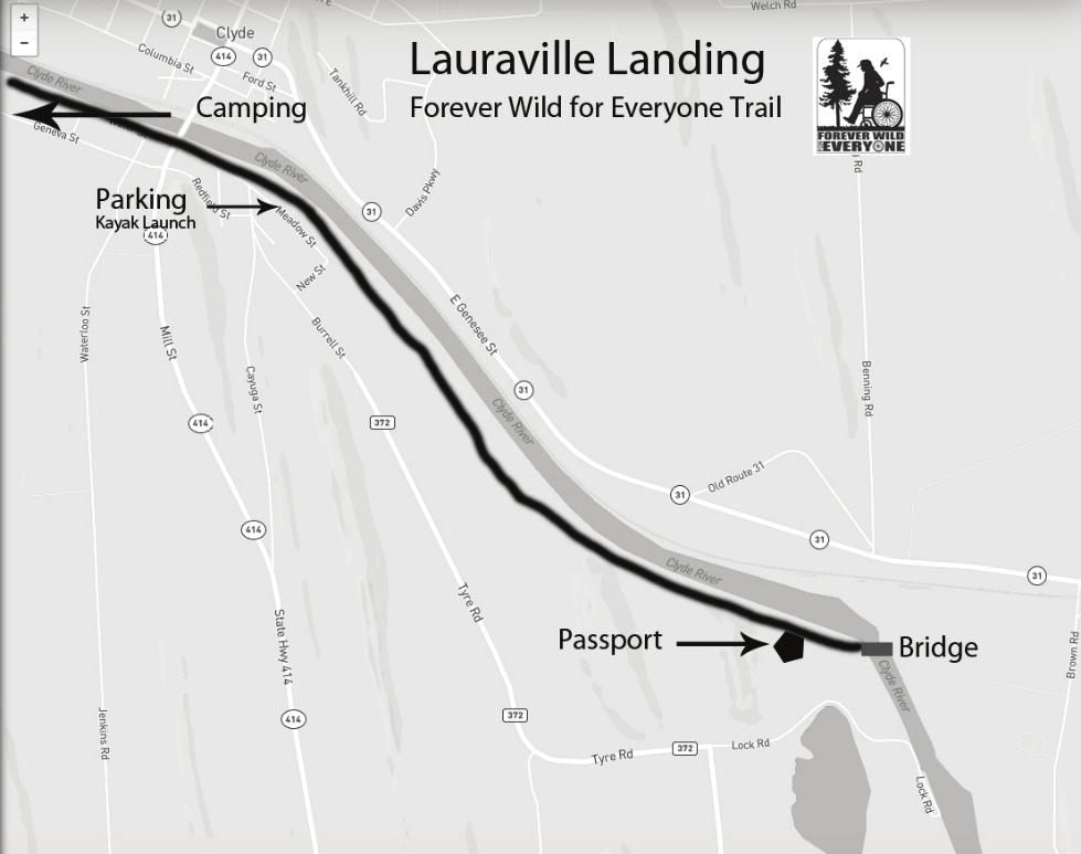
38 Lauraville Landing Trail Location: Located in the of Town of Galen, in the Village of Clyde. Leave the Village of Clyde heading south Rt. 414 cross Erie Canal bridge and make 1 st left onto Redfield St. Turn left onto Orchard Street which will intersect with Water Street. You will see one parking lot ahead of you. There is another to the east where boats can enter the Canal. Hiking Distance: 1.75 miles Difficulty: Easy. This trail is on an old railroad grade. Features: This trail offers a campground to the west of the parking lot by following the trail under the Rt. 414 bridge and walking a quarter mile. At the park there is a playground, picnic pavilion and boat launch for kayaks and canoes. Lauraville Landing Trail was the old West Shore Railroad and is now a stone dust trail through a mix of hardwoods. This trail will eventually cross a bridge over the Erie Canal at 1.75 miles and will be part of the Erie Canal trail system which crosses New York State. When the trail is finished further east of the old railroad bridge, there will be views of the Erie Canal and of Clinton s Ditch. One more note: the old railroad bridge is currently the Low Bridge in this section of the Erie Canal. It is scheduled to be raised in the future. Floor boards will be added to allow pedestrian traffic. MAKE TRAIL RUBBING MARKER HERE
39
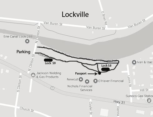
40 Lockville, Newark Location: Access is on North Clinton St. in the Village of Newark. The trail runs between N. Clinton and Lyons St., just north of Rt. 31 and south of the present Erie Canal. Hiking Distance: 1/2 mile Features: Path winds besides and through structures of Old Enlarged Erie Locks 58 and 59. Lock 58 served as a Victory Garden during World War 2. Clinton Ditch Lock 67, 68, and 69 were once also in this area. MAKE TRAIL RUBBING MARKER HERE
41
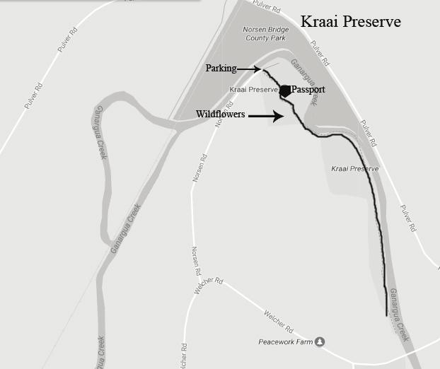
42 Kraai Preserve, Newark Location: The Preserve is located at 2428 Norsen Rd. between Newark and Sodus. From Rt. 88 turn East onto Welcher Rd. At the bend turn north on Norsen Rd., the parking area is at the end of the road. Hiking Distance: 1.5 miles round trip Features: The trail at Kraai Preserve offers a beautiful walk through woodlands and wildflowers along Ganargua Creek. The trail offers views of the Creek, majestic oak trees, and fantastic wildflowers each spring. Adjacent to the Preserve is an Organic Farm which adds beautiful farmland vistas to your walk. MAKE TRAIL RUBBING MARKER HERE
43
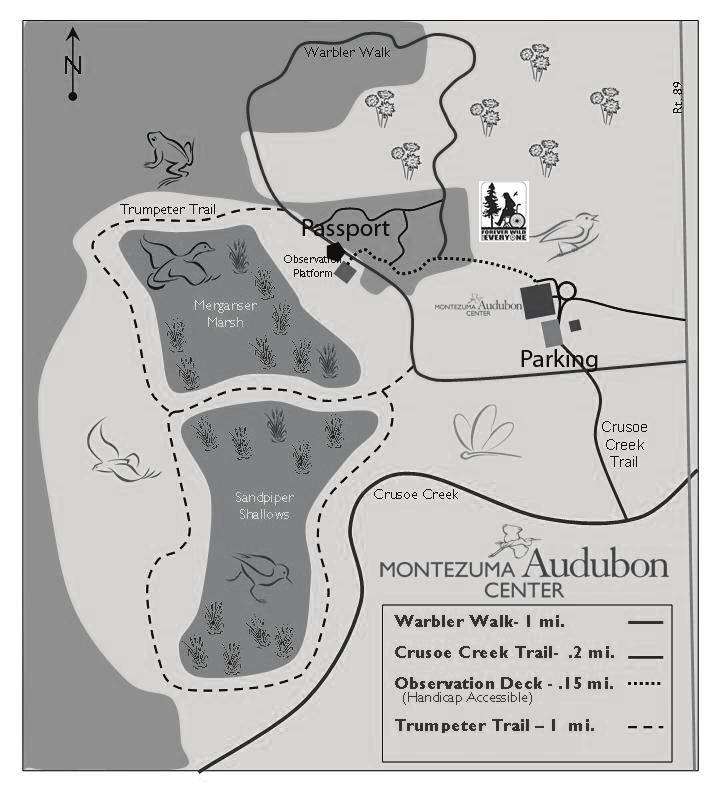
44 Montezuma Audubon Trail, Savannah Location: From the intersection of Route 89 and 31 in the hamlet of Savannah, take 89 north approximately 2 miles. The Montezuma Audubon Center is on the left. Parking is available in the lot. The trail system starts at the north end of the Center. Hiking Distance: 1 mile. Difficultly: Easy. Features: The Warbler Loop Walk begins at the Montezuma Audubon Center and passes by an observation platform that overlooks a restored marsh where you can often see raptors such as red-tailed hawks and osprey, red-winged blackbirds and swallows. The path takes hikers through a diverse forest of hemlock, aspen and maple and then winds through grasslands, home to Northern Harriers and Savannah Sparrows. MAKE TRAIL RUBBING MARKER HERE
45
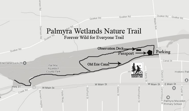
46 Palmyra Wetland Nature Trail Location: On Maple Avenue, 1/4 mile north of the Four Church corner in the center of the Village of Palmyra. Parking in town lot on Canal Street. Hiking Distance: One mile, connected to Erie Canalway Difficulty: Gentle trail, with some narrow points. This is a designated Forever Wild For Everyone Trail along Canal path. Features: Rich in both natural and historical interest. Wetlands formed in excavations of the original Erie Canal. Self-guided Trail Booklet describes flora and fauna at each of the 14 sites along the trail. Good for interest in hiking, birding, jogging, mountain biking, and history of the Erie Canal. Easy access to Aqueduct Park, Aldrich Change Bridge and Lock 29. MAKE TRAIL RUBBING MARKER HERE
47
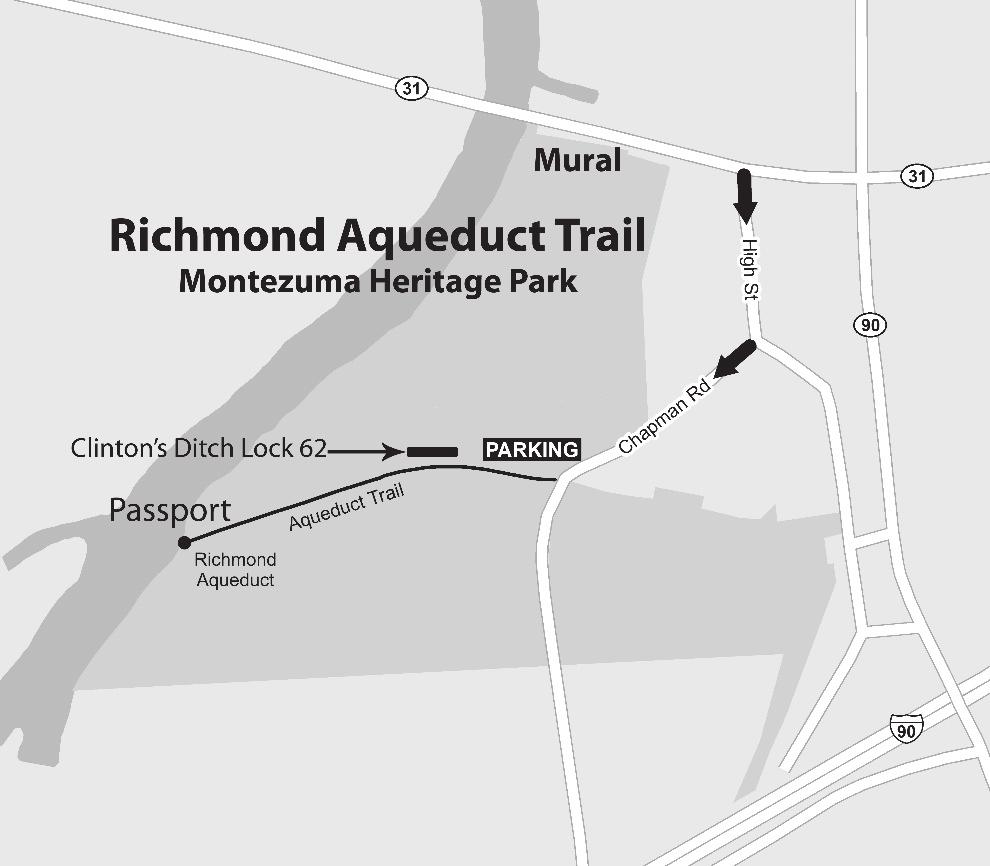
48 Richmond Aqueduct Trail, Montezuma Location: The Aqueduct Trail is located in Montezuma Heritage Park in the Town of Montezuma. On Route 31, take High Street southeast of the Seneca River Bridge. Enter the Montezuma Heritage Park on Chapman Road at a parking lot and kiosk where the Aqueduct Trail #2 starts by an identifying historic roadside marker sign going west to the Seneca River. Hiking Distance: 1/2-mile trail. Difficulty: Easy; hard-ground, well packed and mowed trail where the mules once walked. Description: The trail is one of eleven nature trails in Montezuma Heritage Park that also includes several historic canal sites including Clinton's Ditch Lock 62. The former towpath trail leads to the remains of the second largest aqueduct along the Enlarged Erie Canal. Work began on the water bridge in 1849 consisting of building 31 arches spanning 894-1/2 feet long built to replace the hazards of crossing directly through the Seneca River by lifting the canal over it. Van Rensselaer Richmond, American Civil Engineer and politician from Lyons, NY, designed it. It was dismantled in 1917, to make way for the new Barge Canal. Today seven arches remain on the east side of Seneca River and three on the west side. MAKE TRAIL RUBBING MARKER HERE
49
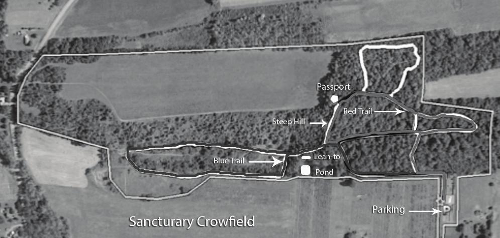
50 Sanctuary at Crowfield Farm Location: Sanctuary at Crowfield Farm is located just off Route 88 north of Newark. From Route 88 turn east onto Pulver Road, turn north on Arcadia Zurich Norris Road. Sanctuary at Crowfield Farm is located ½ mile on the east. Hiking Distance: 3.5 miles of trails. Difficulty: All trails are easy to moderate Features: Nature trails wind through different types of ecosystems, which include a wetland, a meadow, and a beautiful deciduous hardwood forest. Signage for species identification is located along sections of the trails. So, enjoy your hike and keep your eyes open for songbirds, mammals, wildflowers, and other signs of Mother Nature. Great trails for X-country skiing. MAKE TRAIL RUBBING MARKER HERE
51
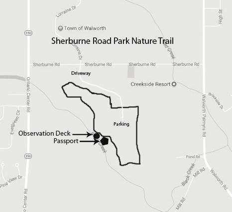
52 Sherburne Park Nature Trail Location: Parking is available on the park access road, which is located on Sherburne Rd. directly across from Lorraine Drive in Walworth. Difficulty: Easy Hiking Distance: Approximately 1 mile Features: The trail is an easy walk around and through Sherburne Road Park. The park and trail feature birding, an observation deck of local wetlands, various native plants, trees, and don t forget the snake boards! Park and trail are dog friendly. MAKE TRAIL RUBBING MARKER HERE
53
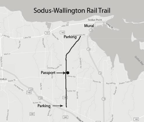
54 Sodus-Wallington Rail Trail Location: This linear trail can be accessed from the North via Margaretta Rd. or from the South at the junction of Ridge Rd. and North Geneva Rd. Hiking Distance: 3-mile Linear Trail, 6 mile round trip. Time will vary. Rubbing post is located midway on the trail. Difficulty: Easy suitable for hiking, skiing or bikes; motorized ATVs and snowmobiles welcome. A wonderful multi-use trail. Features: Abandoned rail bed follows wooded path. Access to Sodus Point Business area is at the north end of trail. There is a mural featuring this railroad in Sodus Point now. MAKE TRAIL RUBBING MARKER HERE
55
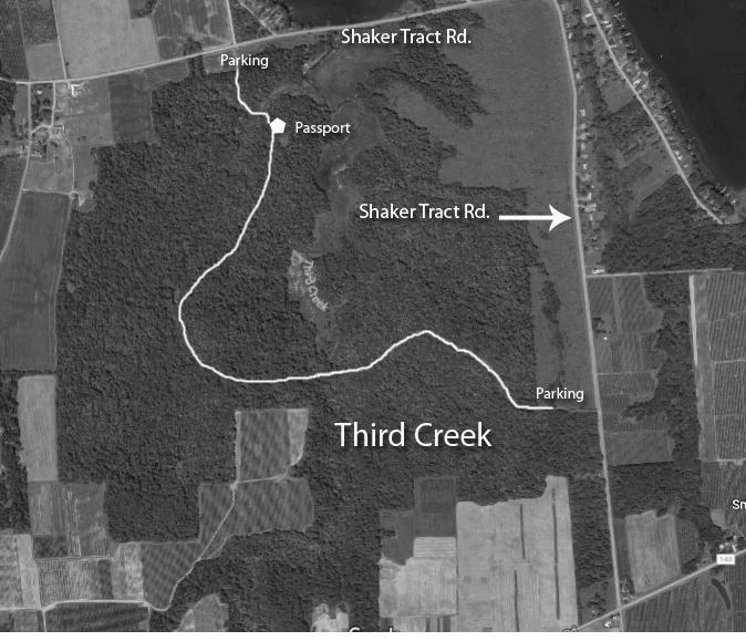
56 Third Creek Location: Third Creek is located in the Town of Huron, north of Ridge Road between Shaker Tract Road and Route 14. From Route 104 turn north on Brick Schoolhouse Road (Shaker Heights sign). Continue across Ridge Road. Parking is available at Southeast Entrance and North Entrance at the mouth of Third Creek on Sodus Bay. See map for details. Hiking Distance: Southeast Trail is approximately 2+ miles long round trip. North Trail is approximately 3+ miles round trip Difficulty: Easy to moderate, following rugged logging trails with elevation changes. Some shallow water hazards during wet periods. Features: The Third Creek land on the south shore of Sodus Bay offers over 500 acres including: mature woodlands, secondary growth, fields, wetlands, and water access to Third Creek, a major tributary to Sodus Bay. The creek itself meanders through the center of the property bordered by bluffs. Sightings of several rare, endangered plants and animals are possible. Spring and fall are exciting for bird watching and raptor identification, including bald eagles. This is truly a wilderness property that feels like the Adirondacks! MAKE TRAIL RUBBING MARKER HERE
57
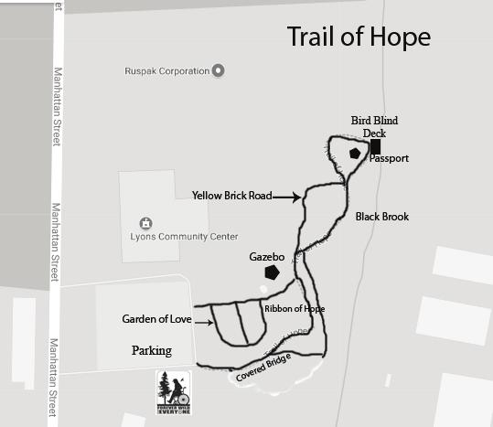
58 Trail of Hope Location: The Trail of Hope is located to the east off the parking at the Lyons Community Center. The location is at the Lyons Community Center turn off of Clyde Road turn onto Manhattan Rd. The LCC is the first right turn, the address is 9 Manhattan St. Hiking Distance: ¼ of a mile. Features: Trail was honored with the Erie Canalway Award of Excellence, Honorable Mention and PTNY Out-of-the-Box Award. The trail meanders through planned theme gardens and into a natural wooded area where native plants dominate. A viewing platform overlooks Black Brook. A covered bridge invites you to explore the special features among which are a willow tunnel, a Conifer Cove, a Therapeutic Pond and Waterfalls, and the Native Way. Birds and butterflies have found new homes at the Trail of Hope. It s more than a garden, it s a healing experience. New features include the Yellow Brick Rd. and the Ribbon of Hope. Allow time to view all the wonderful gardens. MAKE TRAIL RUBBING MARKER HERE
59
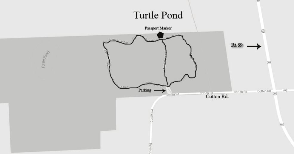
60 Turtle Pond Location: Savannah, NY - Take Cotton Road west from Route 89, just north of the Montezuma Audubon Center. The parking area is on the north side of the road near a sharp turn. Hiking Distance: Approximately 1 mile Description: A unique mix of forested wetland and upland hardwoods border this one-mile, packed dirt trail. Visitor should watch for the many species of wildflowers that grow in this area. In the spring, calls of singing frogs can be heard echoing through the wet woods. Activities: Hiking, Bird Watching, Cross-Country Skiing MAKE TRAIL RUBBING MARKER HERE

61 West Shore Trail Location: Located in the Town of Savannah, the West Shore Trail is a Rail-to-Trail project, on 26 acres of land with approximately 2 miles of trail on the abandoned West Shore Railroad. The trail extends from the Rt. 31/89 bridge in Savannah, crosses VanDyne Spoor Rd and then heads east to the Old Seneca River, which flows into the Erie Canal. The trail is partially surrounded by New York State Department of Environmental Conservation and U.S. Fish and Wildlife Service wetlands. Hiking Distance: 2 miles Difficulty: Easy. This trail is on an old railroad grade.
62 Features: The trail goes through forested wetlands and marshes which provide important habitat for waterfowl, songbirds and birds of prey that migrate thousands of miles along the Atlantic Flyway. Throughout the year, millions of birds and 300 species rest, breed and overwinter here including birds that are threatened, endangered, and species of concern such as the Bald Eagle, Northern Harrier, Short-eared Owl, Cerulean Warbler, American Black Duck and Pied-billed Grebe. There is a picnic area with tables, grills and a fire pit at the east end and a nature and wildlife mural on the concrete railroad trestle abutment. Parking is available at the picnic area and off-street parking is available at the VanDyne Spoor Rd intersection. This trail is also good for biking and skiing. MAKE TRAIL RUBBING MARKER HERE
63
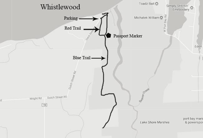
64 Whistlewood Location: Parking lot is at the end of Dutch Street Rd. in Huron, NY. From Rt. 104, Turn North on Lasher Rd. which will become Dutch Street Rd. after crossing Old Ridge Rd. Hiking Distance: There is an extensive trail system offering hikes of varying distances. Over 4 miles of trails. Difficulty: Moderate. Rain/ice causes the first section of the trail to become slippery; use caution. Features: Whistlewood is a former Girl Scout Camp that is now part of the NYS Lakeshore Marshes Wildlife Management Area and managed by the New York State DEC. From the top of the hill, views of Beaver Creek and Lake Ontario are spectacular. Note: Seasonal Hunting is allowed on the property, so hikers should use caution and avoid during hunting season. Great place to cross-country ski. MAKE TRAIL RUBBING MARKER HERE
65
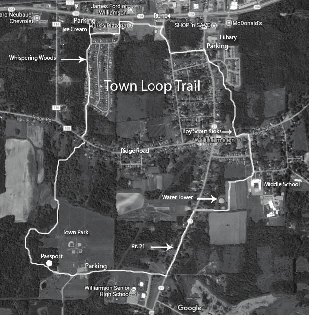
66 Williamson Town Loop Trail Location: Trail access and parking is available at Town Park on Eddy Rd; Route 104 by Ice Cream Shop; or at the Town Hall/Library Complex on Rt. 21. Hiking Distance: 4.2 miles Difficulty: A few steep hills with great views. Much is easy walking. Features: The loop traverses woods, fields, and village streets. There are wonderful views of Lake Ontario on a clear day and rolling farmlands from the top of Herbert s Hill. Access to town, services, and restaurants is available at several points. MAKE TRAIL RUBBING MARKER HERE
67
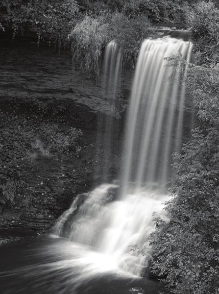
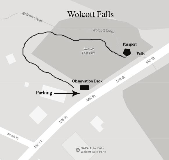
68 Wolcott Falls Hiking Trail Location: From Route 104 in Wolcott, head north on Whiskey Hill Road. Entering the Village of Wolcott, Whiskey Hill Road becomes New Hartford Street. The first traffic light is located by the iconic Venus Rising from the Sea fountain, turn right onto East Main Street. Turn left onto Mill Street. Wolcott Falls Park will be on your left. To find the hiking trail to Wolcott Falls, park and then walk past the pavilion and playground. On the far side of the park and in the wooded area, look for an opening. This is the start of a trail which descends steeply and curves back towards the glen and waterfalls. Hiking Distance: 0.4 miles round trip Difficulty: Moderate. Rain/ice causes the first section of the trail to become slippery; use caution. Features: Wolcott Falls has an attractive 50 foot drop, freefalling in a wide ribbon for half its length and then tumbling down steep shale the rest of the way. About 20 feet from the parking area there exists a handicap-accessible observation deck from which to view the falls, as well as an informational kiosk highlighting the history of Wolcott and the falls itself. MAKE TRAIL RUBBING MARKER HERE
69 PASSPORT FINISH -15 TRAIL NAME ADDRESS PHONE This ticket will enter you in the annual drawing for $250 Wegmans Gift card. Submit to Cornell Cooperative Extension, Rt. 88 in Newark PASSPORT FINISH -30 TRAIL NAME ADDRESS PHONE This ticket will enter you in the annual drawing for $250 Wegmans Gift card. Submit to Cornell Cooperative Extension, Rt. 88 in Newark. Passport Finish - 15 Trails Passport Finish
70
BOOK 2. Discover Wayne County Trails. Trail Works, Inc. is a volunteer group dedicated to trail development and use.
 Trail Works, Inc. is a volunteer group dedicated to trail development and use. Your membership in Trail Works insures that healthy programs like this continue to thrive. Join today at www.trailworks.org
This Passport: Revised October 20, 2017, EAM # Discovering the Trails of Webster, NY
 This Passport: Revised October 20, 2017, EAM #161923 Discovering the Trails of Webster, NY The Town of Webster invites you to explore and experience our diverse outdoor adventures! Here s your opportunity
This Passport: Revised October 20, 2017, EAM # Discovering the Trails of Penfield, NY
 This Passport: Revised October 20, 2017, EAM #161922 Discovering the Trails of Penfield, NY The Town of Penfield is fortunate to have a wide variety of natural resources which make for many unique and
PASSPORT. Discovering the Trails of Webster, NY
 PASSPORT to family wellness Discovering the Trails of Webster, NY Join the Friends of Webster Trails, Webster Health and Education Network, The Town of Webster and Wegmans to get moving more and enjoy
beach. Make the ford and follow the trail out to the junction with Red Creek Tr in an open grassy area.
 Description: This is a moderate to slightly strenuous 22.8 mile backpack (add 2.6 miles if you do the packless out and back to the Lion s Head) that will have you exploring nearly every thing that is The
Hit the Trails. First Day Hikes. Membership. trailworks.org
 Hit the Trails First Day Hikes Membership trailworks.org Over 30 people took part in our Wayne County First Day Hikes, ringing in the New Year at one of three locations: Casey Park, Black Brook Park, and
KETTLE CREEK CONSERVATION AUTHORITY TRAIL GUIDE.
 KETTLE CREEK CONSERVATION AUTHORITY TRAIL GUIDE www.kettlecreekconservation.on.ca EXPLORE OUR TRAILS HIKE OUR TRAILS Kettle Creek Conservation Authority (KCCA) proudly supports and promotes an active lifestyle
This Passport: Revised March 20, 2017, EAM # Discover the Trails of Perinton, NY
 This Passport: Revised March 20, 2017, EAM #161921 Discover the Trails of Perinton, NY The Town of Perinton invites you to explore and experience our diverse outdoor adventures! Here s your opportunity
Stephens State Park Trails
 TRAILS OF ALLAMUCHY MOUNTAIN & STEPHENS STATE PARKS Allamuchy Mountain and Stephens State Parks contain 28 marked trails providing access to diverse landscapes for walking, hiking, biking, bird-watching,
Hiking Trail Descriptions
 Hiking Trail Descriptions For ye shall go out with joy. And be led forth with peace. The mountains and the hills shall break forth before you in singing. And all the trees of the fields shall clap their
Baltimore County Nature Quest NEW TRAILS 2014
 Baltimore County Nature Quest NEW TRAILS 2014 Nature Quest Park Locations Robert E. Lee Park Cromwell Valley Park Agricultural Ctr. & Farm Park Honeygo Regional Park Marshy Point Park and Nature Center
Explore your Town With The Kingston Area Trail Passport
 Explore your Town With The Kingston Area Trail Passport Don t forget to stop at the children's room in the library for your prize when you collect 5 Passport Stamps! For more natural resource related information,
Discovering the Trails of Henrietta, NY
 This Passport: Revised June 8, 2017, EAM #161919 The Town of Henrietta is fortunate to have many wonderful trails to explore. We hope you will enjoy and protect our environment. Always be safe and please
To Wellness. To Wellness PASSPORT PASSPORT. Partners. Partners. Ashland County Health & Human Services 630 Sanborn Avenue, Ashland, WI
 Partners Ashland County Health & Human Services 630 Sanborn Avenue, Ashland, WI Ashland Bretting Center 320 4th Avenue W., Ashland, WI PASSPORT Bayfield County Health Department 117 E. 6th Street, Washburn,
MONTGOMERY TOWNSHIP OPEN SPACE & PATHWAYS COMMITTEE
 MONTGOMERY TOWNSHIP OPEN SPACE & PATHWAYS COMMITTEE Meetings: 2 nd Wednesday of each month @ 6:30 PM in the Municipal Building Questions? Call the Open Space Coordinator, Lauren Wasilauski, at (908) 359-8211
Delaware Wildlife Area
 Delaware Wildlife Area 8 miles away from Delaware 4,670 acre Wildlife Area 1) Take Rt. 36/East Williams Street eastward 2) Take left onto Rt. 42/Lake Street 3) Slight left onto Horseshoe Rd./CR. 220 4)
IOWA ORNITHOLOGISTS' UNION - Birding Sites in Dallas County
 IOWA ORNITHOLOGISTS' UNION - Birding Sites in Dallas County Printed on 7/19/2018 Beaver Bottoms Wetland (restricted) (Important Bird Area) GPS Coordinates:, Ownership: Private (see directions for access)
F.O.K.O.S. Friends of Kingston Open Space A GUIDE TO KINGSTON OPEN SPACE
 F.O.K.O.S. Friends of Kingston Open Space A GUIDE TO KINGSTON OPEN SPACE Friends of Kingston Open Space (FOKOS) was formed when a handful of concerned citizens joined together to learn what could be done
A Publication of Friends of Sleeping Bear Dunes
 A Publication of Friends of Sleeping Bear Dunes 2014, Friends of Sleeping Bear Dunes, P.O. Box 545, Empire, MI 49630 www.friendsofsleepingbear.org info@friendsofsleepingbear.org Learn more about the Friends
Segment 2: La Crescent to Miller s Corner
 goal of the USFWS refuges is to conserve, protect and enhance fish, wildlife and plants and their habitats for the continuing benefit of the American people. Refuge lands are used largely for fishing,
CELEBRATE WEST GREENWICH GEOCACHING THROUGHOUT WEST GREENWICH
 CELEBRATE WEST GREENWICH GEOCACHING THROUGHOUT WEST GREENWICH The West Greenwich Land Trust (WGLT) is sponsoring Celebrate West Greenwich, an event designed to celebrate the beauty and history of scenic
Cuyahoga Valley National Park Ohio
 Cuyahoga Valley National Park Ohio Brandywine Falls The Ledges The Beaver Marsh Temperate Deciduous Forest How To Get There... Located between Cleveland & Akron, Ohio Cuyahoga Valley National Park can
Pinellas County Environmental Lands
 Pinellas County Environmental Lands In addition to traditional parks and recreation facilities, Pinellas County owns and manages a system of environmental lands that provides specialized resource-based
Centred Outdoors is an open invitation for people of all ages and fitness levels to explore ten outdoor destinations in Centre County, Pennsylvania,
 Centred Outdoors is an open invitation for people of all ages and fitness levels to explore ten outdoor destinations in Centre County, Pennsylvania, throughout the summer of 2018. Together, we ll stress
Discover. Ashhurst Domain. Nature s Playground
 Discover Ashhurst Domain Nature s Playground Discover Step back into New Zealand, Aotearoa, of generations long gone. Discover lush natural surrounds echoing with rich birdsong in one of the Manawatu s
Acquisition in fee simple of approximately one-half acre of property on the shore of Spring Lake to expand the Lakeside Beach Park.
 Lakeside Beach TF00-136 $122,550.00 in fee simple of approximately one-half acre of property on the shore of Spring Lake to exp the Lakeside Beach. 2000 River Ravines TF00-150 $910,000.00 in fee simple
Walking Tips. Locations. Good luck on your journey to better health! Earleigh Heights Ranger Station
 Walking Tips Dress in Layers The weather and even your own body temperature can fluctuate as you walk or hike. Layering allows you to comfortably add or remove clothing as needed during your activity.
C E N T R A L C A T S K I L L S
 120 C E N T R A L C A T S K I L L S Central Catskills Once out of the southern parts of the Catskills, the Long Path enters the more well traveled and civilized regions. The trail joins the Devil s Path,
throu Booth Hill Green Belt
 s k r a p s l l u b m u r T Explore gh Geocaching throu Booth Hill Green Belt This was originally a concept to try and preserve some of the land in our town, without hurting the developers that are creating
CRAZY HORSE TRAIL GUIDE
 CRAZY HORSE TRAIL GUIDE Abridged Version: July 2016 This is a short form of our interpretive trail guide for the Crazy Horse Trail. The full version of the guide has a more detailed description of the
Guide to. Suffolk. Walking. Trails. Lake Meade Park
 Walking Lake Meade Park Guide to Suffolk Trails Lake Meade Park Lonestar Lake Regional Park Walking Safety Tips Avoid walking alone on trails. Walking with friends is recommended. Tell someone where you
Beaver Creek State Park
 GENERAL INFORMATION Name of Park/Forest/Facility: Beaver Creek State Park County: Columbiana (St. Clair Township) Address: 12816 Sprucevale Road (ie County Rd 428) (street #, city) East Liverpool, Ohio
Calvert Regional Park - Tari Moore Recreational Trail. Calvert Regional Park - Woodland Trail. miles from Rising Sun
 Calvert Regional Park - Tari Moore Recreational Trail 304 Brick Meeting House Road, North East, MD 21901 5.2 about 1.1 mile Paved parking lot, plentiful Easy, paved path with slight incline. Easy, paved
proof Northwest District
 1 Northwest District The Northwest Florida Water Management District is the most rural of all five water management districts. From just east of Tallahassee west to the Florida/Alabama line, and from the
(/ 12 (/ 18 (/ 18 (/ 12 (/ 51 (/ 14 Æ%106 Æ% 106 Æ% 213 Æ% 104 Æ% 89 Æ% 26 Æ% 73 Æ% 59 Æ% 138 Æ% 92 Æ% 26 Æ% 67 Æ% 11 Æ% 11 Æ% 11. Æÿ H Æÿ Z.
 WAUKESHA Existing Ice Age Trail, subject to change as it evolves toward completion Glacial Drumlin Rail-Trail 94 Ice Age Trail Rock, Walworth and Jefferson Counties Other Trail Unofficial Connecting Route
Marilla Reservoir to Chestnut Ridge via Marilla Trails and Bullis Hollow Trail east to west
 USGS topographic maps useful to this hike are the Bradford and Stickney 7.5 minute sectionals. These notes are designed to assist in identifying distance and location using geophysical and man-made characteristics
Trail Phasing Plan. Note: Trails in the Clear Creek Canyon area (Segments will be finalized in the future to minimize wildlife impacts
 Note: Trails in the Clear Creek Canyon area (Segments 2 5 and a future JCOS connection) will be finalized in the future to minimize wildlife impacts Trail Phasing Plan P Parking 3 Easy Trail Intermediate
3.0 EXISTING PARK & RECREATION SPACE
 3.0 EXISTING PARK & RECREATION SPACE TOWN PARK & RECREATION SPACE An inventory of current parks and recreation area in the Town of Cedarburg is shown in Table 3. These areas total roughly 381.89 acres.
Crystal Lake Area Trails
 Lake Area Trails Welcome to the Lake area of the Big Snowy Mountains! This island mountain range in central Montana features peaks reaching to 8,600 feet and long, high ridges from which vistas of the
Topsham Trail Guide.
 Topsham Trail Guide A guide to the walking, hiking, biking, water and ATV trails of Topsham, Maine and surrounding towns $4.95 Developed by the www.greatertopshamtrailalliance.org The Greater Topsham Trail
Self-guided Tours Tour 4: Warden Woods and The Goulding Estate
 THE TAYLOR MASSEY PROJECT Celebrating and Protecting Taylor Massey Creek Self-guided Tours Tour 4: Warden Woods and The Goulding Estate Reach Partners: The J. Walton House Clairlea Neighbourhood Association
Langton Lake Park Implementation Planning Session One 6 June Attendees signed in
 27 Attendees signed in Meeting summary Following an overview of the Parks and Recreation Renewal Program and the key directions of the Parks and Recreation System Master Plan, meeting participants were
Columbia, Maryland - Village of Owen Brown
 Columbia, Maryland - Village of Owen Brown From the Village of Owen Brown, good trails stretch to other neighboring Columbia villages. Mostly following stream valleys, the trails go to and from schools
Northeast Quadrant Distinctive Features
 NORTHEAST QUADRANT Northeast Quadrant Distinctive Features LAND USE The Northeast Quadrant includes all the area within the planning area that is east of Interstate 5 and to the north of State Route 44.
GOLDEN EARS PROVINCIAL PARK
 GOLDEN EARS PROVINCIAL PARK Trail Information as of October 10 th 2015 Do not underestimate the mountainous wilderness of Golden Ears Provincial Park. The combination of rugged terrain and rapidly changing
PLACES TO WALK IN PORT COQUITLAM
 Places to Walk in Port Coquitlam Port Coquitlam is a walker s paradise, whether you re looking for a leisurely stroll or a challenging trek. Lace up your sneakers and try out these 18 walks submitted by
ABOUT THE PARKS NANTAHALA NATIONAL FOREST MOUNTAINS NATIONAL PARK CHEROKEE NATIONAL FOREST PISGAH NATIONAL FOREST GREAT SMOKY HIKING TRAILS
 ABOUT THE PARKS GREAT SMOKY MOUNTAINS NATIONAL PARK NANTAHALA NATIONAL FOREST CHEROKEE NATIONAL FOREST PISGAH NATIONAL FOREST GREAT SMOKY MOUNTAINS NATIONAL PARK Straddling the border between North Carolina
Driving Time: 3 hours (allow extra time for stops)
") Scenic Byways loop This journey takes visitors through the eastern edge of Mt. Rainier National Park and along two of Washington s most beloved scenic byways, the Chinook Byway and the White Pass Scenic
Scenic Byways loop This journey takes visitors through the eastern edge of Mt. Rainier National Park and along two of Washington s most beloved scenic byways, the Chinook Byway and the White Pass Scenic
Asheville & WNC Hikes
 Asheville & WNC Hikes Amazingly, we have 3,000+ miles of free public hiking trails near Asheville, including 1,600 miles in the Pisgah and Nantahala National Forests, 850 miles in Great Smokey Mountains
Municipal Park Descriptions: 1. Bear Hollow Park 4100 Bear Hollow Park Court, Murrysville, PA acres
 MUNICIPAL PARK DESCRIPTIONS Murrysville has a wide variety of parks and recreational facilities including sports fields, neighborhood parks, community parks, a Community Center, and extensive natural areas
Nature is for everyone to enjoy, so let your followers experience the beauty.
 POCKET GUIDE WHILE YOU RE HIKING For your safety, please watch for loose rocks, tree roots, and other obstacles along the trails. Please park in designated parking areas only. Stay on the marked trail;
PRIEST LAKE TRAILS. More information contact: Priest Lake Ranger District
 PRIEST LAKE TRAILS The varying terrain in the Priest Lake area ranges from river bottoms with an elevation of 2,600 to 7,500 ft. Valley bottoms, dense forests, meadows and occasional clearings and barren
APPENDIX 19-II. Ontario Trail Network Trailheads EAST-WEST TIE TRANSMISSION PROJECT AMENDED ENVIRONMENTAL ASSESSMENT REPORT
 EAST-WEST TIE TRANSMISSION PROJECT AMENDED ENVIRONMENTAL ASSESSMENT REPORT APPENDIX 19-II Ontario Network heads Report. 1536607/2000/2219 Ontario Network heads in the n-commercial Land and Resource Use
Lake Wissota Access Locations within the LaFayette Township. By Chad Martin
 Lake Wissota Access Locations within the LaFayette Township By Chad Martin Anson/ Wissota Access Point # 1 Road: 195 th St. Associated Fire Numbers: 13294 Defining Characteristics: Forested from road
Niagara Natural Heritage Park
 A Future Proposal For the Niagara-on-the-Lake DND Lands....... Parks Canada Lakeshore Road Property 1 May, 2016 The Harmony Residents Group We are proposing a Natural Heritage Park be established on the
Blue Ridge Hiking Club - First Quarter 2018 Hikes
 Blue Ridge Hiking Club - First Quarter 2018 Hikes Monday, Jan 1: Trout Lake to Manor House & Figure 8 Trail: Meet at Trout Lake parking lot, at 9:30. (1st exit left off Parkway just south of Cone Manor
Difficult Run Stream Valley Park
 Difficult Run Stream Valley Park The more intense mountain bikers have known about for Difficult Run for some time. Equestrians have known it longer. Eight miles of unpaved trail, the Rails to River Trail
Camping (Primitive) Camping (RV) Electrical Potable Water Grill Established Fire Pit Picnic Table
 Camping (RV) Electrical Potable Water Grill Established Fire Pit Picnic Table") Alden - 9th Road River Mile 777 Map: 38.20833, -98.32031 Managing Agency: Kansas Department of Wildlife, Parks & Tourism Nearest Community: Alden, Rice County Kansas Developed Amenities Provided Parking
Alden - 9th Road River Mile 777 Map: 38.20833, -98.32031 Managing Agency: Kansas Department of Wildlife, Parks & Tourism Nearest Community: Alden, Rice County Kansas Developed Amenities Provided Parking
UMASS CROSS-COUNTRY Trails
 UMASS CROSS-COUNTRY Trails 1) EGG (43 min) (A) From Cage proceed to North Pleasant street (by campus pond). Make left and head toward LGRT and pass School of Education. Pass Puffton Apt complex (on left)
The Croatan MST Segment 16B
 1 Mountains-to-Sea Trail Last Updated 1/1/2017 A sandy road through longleaf pine savanna in the Croatan National Forest Photo by PJ Wetzel, www.pjwetzel.com The Croatan MST Segment 16B STELLA TO THE NEUSIOK
OTZINACHSON REGIONAL GROUP OF THE SIERRA CLUB Edward Abbey Hiking Society Spring- Summer 2013 Outings Schedule
 For more information contact: Paul Shaw, Outings Chair 155 Mowery Lane Sunbury PA 17801 717-215- 8339 pshaw@ptd.net Saturday, March 23: Switchback Railroad, Carbon County 11 miles, moderate to strenuous.
Field Guide. Nature Nearby. Traverse City
 Field Guide Nature Nearby Traverse City FEATURED PROPERTIES 1 DEEPWATER POINT NATURAL AREA 2 HICKORY MEADOWS NATURAL AREA KALKASKA 3 MAPLE BAY NATURAL AREA E as t A rm G r a n d Tr a v er s e B ay 4 PELIZZARI
Conservation Area Management Statement
 Conservation Area Management Statement Miller Creek Wildlife Area Resolution #: Approval: Issue Date: Date of Last Revision: Table of Contents 1. Purpose....... 1 2. Property Description...... 1 2.1. Legal
Auburn Trail / Ontario Pathways Trail Connector Feasibility Study Public Information Meeting Wednesday, August 22, 2012
 Auburn Trail / Ontario Pathways Trail Connector Feasibility Study Public Information Meeting Wednesday, August 22, 2012 Purpose of Feasibility Study Purpose Evaluate the feasibility of constructing a multiuse
Vermont Cows by Peter Salmon
 Vermont Cows by Peter Salmon SUSTAINABLE FOREST & PROPERTY MANAGEMENT: At current the Dorset Town Forest includes the 30 acre parcel that sits atop Owl s Head peak in Dorset. By acquiring this property
ISLAND PARK MANAGEMENT PLAN AND GUIDELINES
 ISLAND PARK MANAGEMENT PLAN AND GUIDELINES - 2015 Introduction Island Park was a sand dune on the edge of Lake Huron 12,000 years ago. As the lake receded, it left a river channel, the Thunder Bay River.
Understanding user expectations And planning for long term sustainability 1
 Understanding user expectations And planning for long term sustainability 1 What is a natural surface trail? It can be as simple has a mineral soil, mulched or graveled pathway, or as developed as elevated
Sunrise Ranch 6890 acres, Jeff Davis County, Texas On the Fort Davis Scenic Loop
 Sunrise Ranch 6890 acres, Jeff Davis County, Texas On the Fort Davis Scenic Loop 432-386-2821 Cell 432-426-2024 Office james@kinglandwater.com King Land & Water LLC P.O. Box 109, 600 State Street, Fort
West Trails Trek Guide. Chief Pontiac Trail Credential Hikes
 West Trails Trek Guide Kensington Start Edition Chief Pontiac Trail Credential Hikes RDS.WTW.110609 WP# Dist. Accum. Dist. Accum. Feet Miles Meters Meters 1 0 0.0 0 0 2 410 0.1 125 125 3 164 0.1 150 275
TRAILS WHERE TO FIND TRAILS IN NOVA SCOTIA
 TRAILs SIGNAGE Know the Signs............................ 44 WHERE YOU CAN RIDE Roads and Highways........................ 46 Designated Trails........................... 47 Established Trails...........................
San Luis Obispo. Bishop Peak Felsman Loop Eagle Rock Maino Open Space Poly Canyon Poly P Other Areas
 San Luis Obispo Bishop Peak Felsman Loop Eagle Rock Maino Open Space Poly Canyon Poly P Other Areas 1 JCT. ELEV. 72 400 00 0 FELSMAN LOOP GATE LOOP RIDGE 600 FENCE JCT. ELEV. 860 1000 1200 BISHOP PEAK
Little Grand Canyon near Pomona, Illinois
 Little Grand Canyon near Pomona, Illinois Below: View of the trail and the terrain created using the Map My Hike app Below: Summary of the hike created using the Map My Hike app Presented by: Jennifer
S H A W A N G U N K R I D G E T R A I L
 214 Shawangunk Ridge Trail The Shawangunk Ridge Trail was originally conceived as a relocation of the Long Path from Harriman State Park to Minnewaska State Park. Now part of the Long Path system, the
DRAFT - APRIL 13, 2007 ROUTING STUDY FOR TRAIL CONNECTIONS BETWEEN CALAIS AND AYERS JUNCTION
 DRAFT - APRIL 13, 2007 ROUTING STUDY FOR TRAIL CONNECTIONS BETWEEN CALAIS AND AYERS JUNCTION Abstract The vision for the East Coast Greenway is an off-road urban trail system running from Calais, Maine
Androscoggin River Trail Access Sites. North Woods. 168 miles from its source at Lake Umbagog to Merrymeeting Bay
 Androscoggin River Trail Access Sites North Woods 168 miles from its source at Lake Umbagog to Merrymeeting Bay Trail Under Construction More than 40 Public Access Sites Available Androscoggin River Watershed
See Explorer Camp Brochure/ for Ages Ages 4-9
 www.tinmountain.org See Explorer Camp Brochure/ www.tinmountain.org for Ages 10-16 Ages 4-9 SUMMER CAMP 2011 CELEBRATING 27 YEARS OF SUMMER CAMP FOR CHILDREN AGES 4-16 YEARS Tin Mountain s mission is to
H U D S O N P A L I S A D E S
 14 H U D S O N P A L I S A D E S Hudson Palisades The southernmost sections of the Long Path follow the Hudson River and the Hudson Palisades north, staying close to the river and to civilization. Although
B10. Agate Beach State Recreation Site
 B10. Agate Beach State Recreation Site Location Within the City of Newport, just south of the Yaquina Head Outstanding Natural Area. The park is located along the west side of Highway 101 at the mouth
Trail Guide. The Nunckatessett Greenway. Wildlands Trust. AmeriCorps MassLIFT. Bridgewater, MA & West Bridgewater, MA
 This trail guide was compiled by Allison Gillum, Regional Conservationist, and Sarah Kugel, Community Outreach Coordinator, serving at Wildlands Trust through the AmeriCorps MassLIFT program. Wildlands
Cincinnati Nature Center s
 120 60 hikes within 60 miles: cincinnati 24 Cincinnati Nature Center s Rowe Woods i KEY AT-A-GLANCE INFORMATION Length: 8.9 miles Configuration: Loop Difficulty: Difficult Scenery: Forest, ponds, prairie,
FEASIBILITY CRITERIA
 This chapter describes the methodology and criteria used to evaluate the feasibility of developing trails throughout the study areas. Land availability, habitat sensitivity, roadway crossings and on-street
TENNESSEE MOUNTAIN LIVING
 NOVEMBER 2016 Featuring Jasper Highlands TNLand.com END of the YEAR December 26th to Land Sale December 31st See back cover for more info... TENNESSEE MOUNTAIN LIVING JASPER HIGHLANDS - TENNESSEE'S MOST
MISSISSIPPI RIVER VISITOR CENTER
 MISSISSIPPI RIVER VISITOR CENTER Program Guide Page 2 Visiting Us? While visiting our facility your group can experience navigation up close! We offer the best view of the mighty Mississippi River and
GREAT SMOKY MOUNTAINS FAMILY CAMP!
 GREAT SMOKY MOUNTAINS FAMILY CAMP! July 10-15, 2017 SCHEDULE OF EVENTS Monday PM 3:00-5:00 EVE 5:45 WELCOME! Arrival, registration and move in to the dorm. Supper 6:45 Welcome & Orientation & Sign Up for
Mountain Biking and Off Road Trails in Warren County, New York
 Mountain Biking and Off Road Trails in Warren County, New York Warren County Safe and Quality Bicycling Organization 96 Country Club Road Queensbury, NY 12804 www.bikewarrenco.org Warren County Safe and
IOWA ORNITHOLOGISTS' UNION - Birding Sites in Cerro Gordo County
 IOWA ORNITHOLOGISTS' UNION - Birding Sites in Cerro Gordo County Printed on 11/17/2018 Blue-wing Marsh GPS Coordinates: 43.0834956379463,-93.4430980682373 Pure natural area primarily used for hunting.
Listing of Campsites on the Manigotagan River
 Listing of Campsites on the Manigotagan River This document lists and describes the campsites along the Manigotagan River between Highway #314 and the government dock in the community of Manigotagan. The
National Recreation Trail Update Form
 National Recreation Trail Update Form Introduction Thank you for taking the time to complete this form. Your assistance will help ensure that the National Recreation Trail (NRT) database is complete and
BIRDING Lake Fayetteville
 BIRDING Lake Fayetteville Lake Fayetteville is an impoundment of Clear Creek, created as a water supply for Fayetteville in 1949. With development of other water supplies, especially Beaver Lake, Lake
ROAD SCHOLAR SPRING HIKING ADVENTURE Tentative Schedule April 8-13, 2018
 Sunday, April 8 ROAD SCHOLAR SPRING HIKING ADVENTURE Tentative Schedule April 8-13, 2018 PM 3:00-5:00 Arrival, registration and move in to the dorm. 6:00 Supper EVE 7:00 Welcome & Orientation, Sign Ups
Guide to Your Adventure Walk
 Guide to Your Adventure Walk 7 Are you ready to search for some Michigan plants and animals? Grab your backpack, or borrow one from the garden store, and let s get started! On this hike you will see many
Section 7: Pick Up Where You Left Off! S-Tree Road over the Todd Road
 2018 TRACE NOTES Helpful information for your adventure on Section 7 of the Hiker Challenge. Start Point S-Tree Rd. End Point Intersection Todd Rd. / Hale Ridge Rd. WEATHER DECISION Weather Alert!!!! Potential
ASRA 2018 Hike Schedule
 ASRA 2018 Hike Schedule Date/Day Destination Hike Info Meeting Info Leader Feb 10, Saturday Stagecoach and 9:00 at the Confluence kiosk. Manzanita trails Parking fee required. We ll hike along the trail
National Recreation Trail Application for Designation
 National Recreation Trail Application for Designation Introduction Thank you for your interest in the National Recreation Trail (NRT) program. Completed NRT application packages must be submitted by December
ONTARIO TRAILS COUNCIL FAQ
 Trail Facts Ontario has some of the most treasured and protected outdoor areas in the world with: 329 Provincial Parks 400 Conservation Areas 292 Conservation Reserves Many people link trails with recreation
Non-motorized Trail Plan & Proposal. August 8, 2014
 Town of Star Valley Ranch, Wyoming and the Star Valley Ranch Association in partnership with the USDA Forest Service, Bridger-Teton National Forest, Greys River Ranger District Non-motorized Trail Plan
THOMAS A. SWIFT METROPARK Introductions History Present Conditions Future Development Plans Implementation Strategies Statistics
 THOMAS A. SWIFT METROPARK Introductions History Present Conditions Future Development Plans Implementation Strategies Statistics Introduction As an open meadow park positioned along the Mahoning River,
LAS VARAS RANCH CA COASTAL TRAIL PROPOSED ALIGNMENT
 LAS VARAS RANCH CA COASTAL TRAIL PROPOSED ALIGNMENT Santa Barbara Trails Council * Prepared by Ray Ford February 1,2012 The following notes accompany the Santa Barbara Trails Council map for the Las Varas
16.5 Mile Trek Guide. Chief Pontiac Trail Credential Hikes RDS.H
 16.5 Mile Trek Guide Chief Pontiac Trail Credential Hikes RDS.H.110609 WP# Dist. Feet Accum. Miles Dist. Meters Accum. Meters 1 0 0.0 0 0 2 961 0.2 293 293 3 820 0.3 250 543 4 866 0.5 264 807 4a 407 0.6
ADVENTURE. Activities Offerings ADVENTURE
 Activities Offerings ADVENTURE ADVENTURE Situated on 4,200 acres with 5,000 additional acres of private wilderness, Blackberry Farm is its own unique piece of private wilderness, but surrounding the farm