PRIEST LAKE TRAILS. More information contact: Priest Lake Ranger District
|
|
|
- Brian Chambers
- 5 years ago
- Views:
Transcription
1 PRIEST LAKE TRAILS The varying terrain in the Priest Lake area ranges from river bottoms with an elevation of 2,600 to 7,500 ft. Valley bottoms, dense forests, meadows and occasional clearings and barren ridges are harmoniously mixed with streams, rivers and lakes. Because of the wide variety of plant communities, there is a great diversity of animal and bird life. White tail and mule deer, mountain caribou, grizzly bear, black bear, moose, mountain lion are found in the forest along with mink, marten, weasel, porcupine, beaver, bobcat, lynx, coyote, squirrel, chipmunks and other small animals. Bird species include many blue and ruffed grouse, jays, ravens and songbirds. Osprey, bald eagles, and golden eagles are found because of the water and fisheries resource. The Aleutian Low dominates North Idaho's weather from late September to late June. Cool, moist storm systems are borne eastward from the Pacific by prevailing westerly winds. Contact of these maritime air masses with the cold, dry air of the plains can result in short bursts of heavy precipitation, but most spring, fall and winter storms are of low intensity and long duration. At last, as July approaches, the subtropical Pacific High moves northward and summer arrives in North Idaho. This is the period of thunderstorms, the worst of which are triggered when cool northern Pacific air meets warm, moist California coast air. Late August often sees a brief but intense invasion of this cool northern air that leaves snow on the higher mountains. September 20, is the average time for the abrupt transition back to cool, wet weather. Many trails on the Priest Lake District offer the opportunity for dispersed camping. Be sure to choose a site wisely. Trenching and leveling for a tent leaves scars on the area that takes years to heal. Pick a spot where digging is unnecessary. Your site should be at least 100 feet away from the lakeshore and away from the main trail to give yourself and other travelers the solitude you are seeking. Remember "Leave No Trace"! There may be hazard associated with drinking untreated "natural" water. It is an intestinal disorder called GIARDIASIS (gee-ar-dye-a-sis). It can cause severe discomfort. Play it safe and carry a supply of water from home or other domestic source. Exploring our trails can be an adventure in discovery for you and your family or friends. We hope you enjoy your time on the Priest Lake Ranger District. More information contact: Priest Lake Ranger District
2 Trail # Elev. Begin Elev.Ending TRAIL INFORMATION Length in Miles Use Level Difficulty Level Trails Open to: ft ft. 6.0 H E F H E F M D F,P,M,MB L M F,P,M,MB M M to D F,P,M,MB,A M M to D F,P,M,MB M M to D F,P,M,MB,A M M to D F,P,M,MB M E to M F,P,MB H E F,P,MB H E F,P,MB L to M D F,P,MB M E F,P,MB H E F,P,MB H D F,P,MB M D *F Use Level Difficulty Level Key Trails Open to: * L - low E - easy F - foot Not Recommended for M - M - horses P - pack/saddle medium moderate H - high D - difficult M - motorcycle MB - mtn. bike A - ATV Last updated: 05/23/05

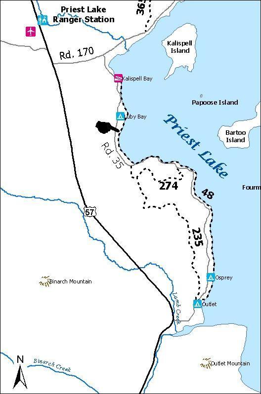
3 BEACH TRAIL (#48) Access: (two access points and may have a small fee for parking) 1) Off of Highway 57, turn onto (milepost 31¼) Kalispell Bay Road. Travel approx. 1 mile and turn right onto the West Lakeshore Road towards the Priest Lake Marina. Just past the marina, turn left at the Kalispell Bay Boat Launch. Trail access is south of the parking area. View of Priest Lake from the Beach Trail. 2) Off of Highway 57 turn (milepost 26) onto Outlet Bay Road. Travel approx. ¼ mile, turn left onto Lakeshore Rd. approx. ½ mile turn right at the Outlet Bay campground. Trail access is at the campground. Route length: 6.0 miles Difficulty: Easy Useage: High Restrictions: Open to foot traffic only Comments: This trail is an easy hike which follows along the lakeshore and passes in front of several summer homes. Twice the trail leads out to the Lakeshore Road and one must follow the road until the trail takes off into the woods again which is marked by a white diamond on a tree. This trail goes to Hill's Resort and also passes by Luby Bay Campground. More information contact: Priest Lake Ranger District
4

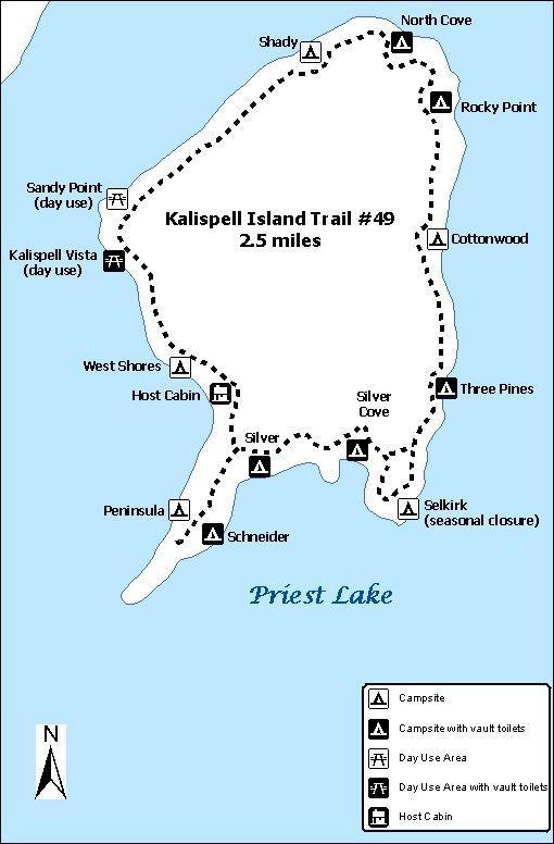
5 KALISPELL ISLAND TRAIL (#49) Access: (direction to the Kalispell public boat launch) Off of Highway 57, turn (milepost 31¼) onto Kalispell Bay Road. Travel approx. 1 mile and turn right onto the West Lakeshore Road towards the Priest Lake Marina. Just past the marina turn left at the Kalispell Bay Boat Launch. Beach area on Kalispell Island. This trail is only accessible by boat. Boaters can access the island by going to Kalispell Vista or Sandy Point Day Use areas. Once on the island, the trail can be accessed from any point. Route length: 2.5 miles Difficulty: Easy Useage: High Restrictions: Open to foot traffic only Comments: This trail is an extremely easy hike around Kalispell Island. The trail runs along the back of campsites, so staying on the trail is important. More information contact: Priest Lake Ranger District
6
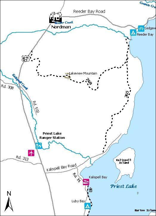
7 LAKEVIEW MTN TRAIL (#269) Access: Located on Hwy 57, between milepost 35 and 36 across from Bismark Meadows. Parking limited to about 4 vehicles or 2 stock trailers. Back in parking. Other access is at the intersection with Trail #365. Route length: 5.3 miles Difficulty: Difficult Useage: Low Comments: Takes off from Hwy 57 and starts to switchback up Lakeview Mountain. The first views of the lake and its surrounding area is offered 2 miles from the start where one may take a short hike to an open hillside. If one continues on the trail, several more views of Priest Lake are offered until the trail starts to gradually switchback down the east side of the mountain. This passes through stands of alder, pine, young cedar and open hillsides of brush. Trail is narrow and steep in places. More information contact: Priest Lake Ranger District Click on a trail or trail number for information about the other trails on this map
8
9 KALISPELL-REEDER BAY TRAIL (#365) Access: (trail has two access points) South trailhead #365: Parking is located on the south side of Kalispell Bay Road at the day use area. The trail is located on the north side of Kalispell Bay Rd. Follow the road behind the gate for approximately 1 mile until you see a sign for the Lakeview Trail #365 to the right. North trailhead #365: Located at the southern end of Elkins Resort parking lot, near the lodge. Cross bridge across Reeder Creek and follow trail from that point. Route length: 4.2 miles Difficulty: Moderate Useage: Low Comments: Trail #365: Has several scenic views of the lake along the trail. The trail crosses an old ski hill on the southern end and passes through private land on the north end. This trail is an ideal day's trip for parties with two vehicles who can leave a vehicle at either end of the trail. Tread is narrow & steep in places. More information contact: Priest Lake Ranger District Click on a trail or trail number for information about the other trails on this map
10
11 JOHN WAYNE (#176) TRAIL Access: Hwy 57, across from the Falls Inn Travern 8.7 miles up turn onto the Peterson Road and travel approx. 2 miles. Trailhead is located on the left hand side, with limited parking available on the opposite side of the road in a pullout. Route length: 2.9 miles Difficulty: Moderate to Difficult Useage: Moderate Comments: Open to ATVs. Part of the Peewee/Steep Creek trail system. Trail system is a series of interconnected loops and each trail can be accessed from several different points. Some loops gain elevations that view the Priest & Pend'Orielle River Valley's. Some sections are located on the old road bed while others are steep and rocky. More information contact: Priest Lake Ranger District Click on a trail or trail number for information about the other trails on this map
12
13 STEEP CREEK (#177) TRAIL Access: Approx. 3.5 miles up Hwy 57 turn onto the Pennisula Road. Travel approx. 4 miles. Turn left on Forest Service Rd. #334 (Gleason-McAbee Falls Rd.), which is right before the Green Owl Tavern and continue 2.2 miles and turn left on road #416 and go approx. 2 miles. Trailhead is located on the left. Route length: 2.5 miles Difficulty: Moderate to Difficult Useage: Moderate Comments: Part of the Peewee/Steep Creek trail system. Trail system is a series of interconnected loops and each trail can be accessed from several different points. Some loops gain elevations that view the Priest & Pend'Orielle River Valley's. Some sections are located on the old road bed while others are steep and rocky. More information contact: Priest Lake Ranger District Click on a trail or trail number for information about the other trails on this map
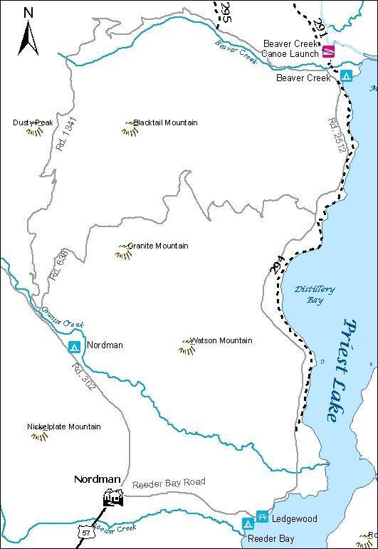
14 PEEWEE TRAIL (#178)
15 Access: Approx. 3.5 miles up Hwy 57 turn onto the Pennisula Road. Travel approx. 4 miles. Turn left on Forest Service Rd. #334 (Gleason-McAbee Falls Rd.), which is right before the Green Owl Tavern and continue 1 mile. Trailhead is located past the gravel pit on the left. Route length: 6.0 miles Difficulty: Moderate to Difficult Useage: Moderate Comments: Open to ATVs. Part of the Peewee/Steep Creek trail system. Trail system is a series of interconnected loops and each trail can be accessed from several different points. Some loops gain elevations that view the Priest & Pend'Orielle River Valley's. Some sections are located on the old road bed while others are steep and rocky. More information contact: Priest Lake Ranger District Click on a trail or trail number for information about the other trails on this map
16
17 QUARTZ VIEW TRAIL (#179) Access: Approx. 3.5 miles up Hwy 57 turn onto the Pennisula Road. Travel approx. 4 miles. Turn left on Forest Service Rd. #334 (Gleason-McAbee Falls Rd.), which is right before the Green Owl Tavern and continue 1 mile. Trailhead is located past the gravel pit on the left. Route length: 6.0 miles Difficulty: Moderate to Difficult Useage: Moderate Comments: Part of the Peewee/Steep Creek trail system. Trail system is a series of interconnected loops and each trail can be accessed from several different points. Some loops gain elevations that view the Priest & Pend'Orielle River Valley's. Some sections are located on the old road bed while others are steep and rocky. More information contact: Priest Lake Ranger District Click on a trail or trail number for information about the other trails on this map
18

19 CHIPMUNK RAPIDS TRAIL (#192) Access: From Priest River, Idaho, go north 22.3 miles on Highway 57 to the Priest Lake Information Center. The trail is located behind the kiosks to the east. Stock trailer parking is at the gravel pit about 0.2 miles north of the Information Center. There you will find trail access behind the locked gate. Route length: 10.4 miles Difficulty: Easy to Moderate Rafters on Chipmunk Rapids. Useage: Moderate Comments: This trail utilizes, for the most part, an old road system so the trail is quite wide. High points along the trail is the Kaniksu Marsh, Priest River and Chipmunk Rapids. Watch for moose, deer, and waterfowl that frequently use the marsh. A long loop can be done utilizing road 2244A but be aware that this road is open to vehicles. More information contact: Priest Lake Ranger District
20
21 LAKESHORE TRAIL (#294) Access: (several access points) 1) At Nordman, turn onto Reeder Bay Road. Approx. 4¼ miles Reeder Bay Rd. turns into Forest Service Rd. #2512. The first trailhead is located approx. ½ mile on your right marked "Lakeshore Trail". Two additional access points can be found along the #2512 Rd. 2) Trail can also be accessed at the Beaver Creek Campground located approx. 12 miles north of Nordman. Trailhead is located south of the parking area. Parking is limited for stock trailers at all trailheads. First trailhead for parking is best. Beaver Creek has no parking for stock trailers. Route length: 7.0 miles Difficulty: Easy Useage: High Comments: This is a popular and well used trail on this district. Easy hiking parallels Priest Lake and crosses five streams. Many views of the lake are offered. This trail passes through dog hair stands of timber and also upon hillsides of brush. There are numerous campsites along the trail offering beaches, isolation and wind protection. More information contact: Priest Lake Ranger District Click on a trail or trail number for information about the other trails on this map
22
23 NAVIGATION TRAIL (#291) Access: (several access points) 1) At Nordman turn east onto Reeder Bay Road. Stay on the main road approx. 14 miles to Beaver Creek Campground. Turn right toward the campground then left uphill to the trailhead. Pull-through park available for trailers. 2) North on Hwy 57, Hwy 57 turns into graveled Forest Service Rd #302 approx. 4 miles past Nordman. Travel north on Rd. #302 approx. 14 miles until it turns into Rd. #1013 at the Granite Pass junction. The road to the trailhead is on the right side, located 5.5 miles up Rd. #1013. (1 mile past the Hughes Meadows turnoff.) Stock trailer parking available. 3) Trail can also be reached via Plowboy Mtn. Trail #295. Route length: 8.1 miles Difficulty: Easy Useage: High Comments: This is an excellent trail. Developed campgrounds located at the north end of Upper Priest Lake (Navigation Campground) and the south end of Upper Priest Lake (Plowboy Campground). The trail passes through valley and sidehill terrain. Along the trail there is an old trappers cabin, beaver ponds, abundant wildlife and scenic views. More information contact: Priest Lake Ranger District Click on a trail or trail number for information about the other trails on this map
24 PLOWBOY MTN TRAIL (#295)
25 Access: (several access points) 1) At Nordman turn east onto Reeder Bay Road. Stay on the main road approx. 14 miles to Beaver Creek Campground. veer left on Forest Service Rd. #1341. Trailhead is approx. 2½ miles on your right. 2) Trail can also be reached via Navigation Trail #291. Route length: 6.0 miles Difficulty: Difficult Useage: Low to Moderate Comments: This trail offers so much beauty in terrain and scenic views of Upper Priest Lake. This trail is very steep. More information contact: Priest Lake Ranger District Click on a trail or trail number for information about the other trails on this map
26 UPPER PRIEST LAKE TRAIL (#302)
27 Access: North on Hwy 57, Hwy 57 turns into graveled Forest Service Rd #302 approx. 4 miles past Nordman. Travel north on Rd. #302 approx. 11 miles until it turns into Rd. #1013 at the Granite Pass junction. Travel Rd. #1013 north approx. 9 miles. and turn onto Rd. #655. Trailhead is approx. ½ mile in on Rd. #655 on the left, trail is on the right. Stock trailer parking available but limited. Route length: 5.0 miles Difficulty: Easy Useage: Moderate Comments: Grizzly bear/caribou Habitat This trail offers a pleasant, easy hike to Upper Priest Lake. The first four miles of the trail are in timber cover until you reach the lake where it then opens up and follows the shoreline until reaching Trapper Creek Campground. The trail passes by an old mine shaft and also Coolin's cabin. More information contact: Priest Lake Ranger District Click on a trail or trail number for information about the other trails on this map
28 UPPER PRIEST RIVER TRAIL (#308)
29 Access: North on Hwy 57, Hwy 57 turns into graveled Forest Service Rd. #302 approx. 4 miles past Nordman. Travel north on Rd. #302 approx. 11 miles, until it turns to Rd. #1013 at the Granite Pass junction. Travel Rd. #1013 north approx. 11½ miles. Trailhead is located on the left side. Ample stock trailer parking is available on both sides of the road. Route length: 8.1 miles Difficulty: Easy Useage: High Comments: Grizzly bear/caribou Habitat This is a very scenic trail and receives heavy use. It is an easy hike and offers excellent views of old growth cedar and lush river bottom vegetation. The length of this trail follows along the Upper Priest River and ends at the junction of Continental Creek Trail, #28 which continues on to the Upper Priest River Falls also know as the American Falls. The trail has been reworked with new puncheon bridges and crossings. More information contact: Priest Lake Ranger District Click on a trail or trail number for information about the other trails on this map
30
31 CONTINENTAL CREEK TRAIL (#28) Access: North on Hwy 57, Hwy 57 turns into graveled Forest Service Rd. #302, approx. 4 miles past Nordman. Travel north on Rd. #302 approx. 11 miles until it turns into Rd. #1013 at the Granite Pass junction. Continue north approx. 25 miles. Trailhead is near the end of road on your left and just before the locked gate. Trail ends up at Upper Priest River Falls, also known as the American Falls. Road past 308 trialhead not recommended to stock trailers due to rough road and tight switchbacks. Route length: 2.3 miles Difficulty: Difficult Useage: High Comments: Grizzly bear/caribou Habitat This is one of the most scenic trails on the district. It switchbacks down from Rd. #1013 through an old growth cedar stand to the river bottom. Huckleberries, thimbleberries, devils club and ferns grow thick along the trail. Once to the river, the trail leads to an open flat area which offers an excellent camping spot. The trail then crosses a fork of the Upper Priest River and follows it to the falls near the Canadian Border. A short section of the trail near the falls, which climbs above the river, is steep and lacks tread. This may cause difficulty for some to hike the full distance to the falls. Use caution. More information contact: Priest Lake Ranger District Click on a trail or trail number for information about the other trails on this map
32
33 LITTLE SNOWY TOP TRAIL (#349) Access: From the Granite Pass junction Rd #1013 travel north approx. 11½ miles to trail #308, which is on the left. Trailhead #349 is 4½ miles north on trail #308. Trail ends at junction #512. Route length: 4.7 miles Difficulty: Difficult Useage: Moderate Comments: Grizzly bear/caribou Habitat This trail is the most difficult hike on this district, but it is well worth the effort. It begins at the junction of Trail #308, Upper Priest River Trail and almost immediately the Upper Priest River has to be forded. Once across, the trail starts to gradually climb through an old growth stand until you reach the switchbacks. A sign on a tree states there are 72 switchbacks to the Shedroof Divide Trail #512. Sections of the trail are sloughing off due to steep hillsides. This trail is recommend for only those who want to hike an arduous trail and are in good physical shape. Not recommended for stock. More information contact: Priest Lake Ranger District Click on a trail or trail number for information about the other trails on this map
34
Trail Beginning Elevation: 7553 ft The Poison Creek Trailhead is located at the end of National Forest Road 646E (NF-646E).
.") West Mountain Trails Poison Creek Trail #134 Length: 2.9 miles (4.7 km) Difficulty Horseback: A good trail for the first time west mountain rider, some steep sections Hiking: Most Difficult USGS Maps:
West Mountain Trails Poison Creek Trail #134 Length: 2.9 miles (4.7 km) Difficulty Horseback: A good trail for the first time west mountain rider, some steep sections Hiking: Most Difficult USGS Maps:
playwinterpark.com Off The Beaten Path Hikes Hiking Recommendations for the Adventurous Hiker
 playwinterpark.com Off The Beaten Path Hikes Hiking Recommendations for the Adventurous Hiker Hike: Devil s Thumb (difficult) Length: 3.93 miles one-way Elevation: Trailhead 9609 Destination 12,236 Trailhead
B HALL RANCH FISHTAIL, MONTANA
 Brochure Courtesy of: B HALL RANCH FISHTAIL, MONTANA w w w. m c c a s l i n l a n d. c o m Page 1 LOCATION The Hall Ranch is ideally located in the foothills of the Beartooth Mountains, approximately 5
TRAILS SANDPOINT RANGER DISTRICT IDAHO PANHANDLE NATIONAL FORESTS. Sandpoint Ranger District 1602 Ontario Street Sandpoint, Idaho (208)
") USDA Forest Service Northern Region IDAHO PANHANDLE NATIONAL FORESTS SANDPOINT RANGER DISTRICT TRAILS Sandpoint Ranger District 1602 Ontario Street Sandpoint, Idaho 83864 (208) 263-5111 HTTP://WWW.FS.USDA.GOV/IPNF
USDA Forest Service Northern Region IDAHO PANHANDLE NATIONAL FORESTS SANDPOINT RANGER DISTRICT TRAILS Sandpoint Ranger District 1602 Ontario Street Sandpoint, Idaho 83864 (208) 263-5111 HTTP://WWW.FS.USDA.GOV/IPNF
Trail Phasing Plan. Note: Trails in the Clear Creek Canyon area (Segments will be finalized in the future to minimize wildlife impacts
 Note: Trails in the Clear Creek Canyon area (Segments 2 5 and a future JCOS connection) will be finalized in the future to minimize wildlife impacts Trail Phasing Plan P Parking 3 Easy Trail Intermediate
Non-motorized Trail Plan & Proposal. August 8, 2014
 Town of Star Valley Ranch, Wyoming and the Star Valley Ranch Association in partnership with the USDA Forest Service, Bridger-Teton National Forest, Greys River Ranger District Non-motorized Trail Plan
Hiking Trail Descriptions
 Hiking Trail Descriptions For ye shall go out with joy. And be led forth with peace. The mountains and the hills shall break forth before you in singing. And all the trees of the fields shall clap their
PAUL S PLACE ELK, DEER AND VIEWS FISHTAIL, MONTANA
 McCaslin Land 2010 PAUL S PLACE ELK, DEER AND VIEWS FISHTAIL, MONTANA LOCATION Paul s Place is ideally located in the foothills of the Beartooth Mountains, approximately 5 to 5-1/2 miles west of Fishtail,
Crystal Lake Area Trails
 Lake Area Trails Welcome to the Lake area of the Big Snowy Mountains! This island mountain range in central Montana features peaks reaching to 8,600 feet and long, high ridges from which vistas of the
Section 7: Pick Up Where You Left Off! S-Tree Road over the Todd Road
 2018 TRACE NOTES Helpful information for your adventure on Section 7 of the Hiker Challenge. Start Point S-Tree Rd. End Point Intersection Todd Rd. / Hale Ridge Rd. WEATHER DECISION Weather Alert!!!! Potential
Lava Mountain Trail Distance: Elevation Range: Trail Type: Difficulty: Season: Driving Distance: Driving Time: USGS Maps: Pros Cons
 Lava Mountain Trail Distance: 13.4 miles (including the side trip to North Star Lake) Elevation Range: 5900'-8330' Trail Type: singletrack Difficulty: moderate Season: late June-October Driving Distance:
YOSEMITE ON HORSEBACK: THREE RIDES ALONG TIOGA ROAD Cindy Casey White Wolf Area, May Lake Loop, Ragged Peak Loop
 YOSEMITE ON HORSEBACK: THREE RIDES ALONG TIOGA ROAD Cindy Casey White Wolf Area, May Lake Loop, Ragged Peak Loop The high country along Tioga Road presents us with some of the most dramatic scenery in
beach. Make the ford and follow the trail out to the junction with Red Creek Tr in an open grassy area.
 Description: This is a moderate to slightly strenuous 22.8 mile backpack (add 2.6 miles if you do the packless out and back to the Lion s Head) that will have you exploring nearly every thing that is The
APPENDIX 19-II. Ontario Trail Network Trailheads EAST-WEST TIE TRANSMISSION PROJECT AMENDED ENVIRONMENTAL ASSESSMENT REPORT
 EAST-WEST TIE TRANSMISSION PROJECT AMENDED ENVIRONMENTAL ASSESSMENT REPORT APPENDIX 19-II Ontario Network heads Report. 1536607/2000/2219 Ontario Network heads in the n-commercial Land and Resource Use
A Publication of Friends of Sleeping Bear Dunes
 A Publication of Friends of Sleeping Bear Dunes 2014, Friends of Sleeping Bear Dunes, P.O. Box 545, Empire, MI 49630 www.friendsofsleepingbear.org info@friendsofsleepingbear.org Learn more about the Friends
Stein Valley Nlaka pamux Heritage Park
 Stein Valley Nlaka pamux Heritage Park - Trail Information Update and Winter Advisory November 2017 March 2018 Welcome to Stein Valley Nlaka pamux Heritage Park! **This trail update is to inform park users
Rogue Gorge (Mt. Stella) Roadless Area-- T30S R3E (primarily in portions of Sections 23, 26, 33, 34 & 35)
 Roadless Area-- T30S R3E (primarily in portions of Sections 23, 26, 33, 34 & 35)") Rogue Gorge (Mt. Stella) Roadless Area-- T30S R3E (primarily in portions of Sections 23, 26, 33, 34 & 35) Rogue River-Siskiyou National Forest--High Cascades Ranger District Upper, higher elevation trail
Rogue Gorge (Mt. Stella) Roadless Area-- T30S R3E (primarily in portions of Sections 23, 26, 33, 34 & 35) Rogue River-Siskiyou National Forest--High Cascades Ranger District Upper, higher elevation trail
Garibaldi Provincial Park Trail Conditions
 Garibaldi Provincial Park s August 2, 2018 Garibaldi Park is located in the coast mountain wilderness and the weather can be severe and unforgiving. Be well prepared, properly equipped and informed before
GOLDEN EARS PROVINCIAL PARK
 GOLDEN EARS PROVINCIAL PARK Trail Information as of October 10 th 2015 Do not underestimate the mountainous wilderness of Golden Ears Provincial Park. The combination of rugged terrain and rapidly changing
Stephens State Park Trails
 TRAILS OF ALLAMUCHY MOUNTAIN & STEPHENS STATE PARKS Allamuchy Mountain and Stephens State Parks contain 28 marked trails providing access to diverse landscapes for walking, hiking, biking, bird-watching,
Your Guide to Mountainbiking around Atlin (yes, you can hike these trails as well)
") Your Guide to Mountainbiking around Atlin (yes, you can hike these trails as well) Foreword Thanks to the rich mining history in Atlin, the historic mining roads have become the perfect trails for recreational
Your Guide to Mountainbiking around Atlin (yes, you can hike these trails as well) Foreword Thanks to the rich mining history in Atlin, the historic mining roads have become the perfect trails for recreational
TAYLOR CANYON RANCH COLORADO - ROUTT COUNTY - STEAMBOAT SPRINGS
 TAYLOR CANYON RANCH COLORADO - ROUTT COUNTY - STEAMBOAT SPRINGS Tucked up against the steep valley shaped by Mt. Pau and rising to the Routt National Forest, Taylor Canyon Ranch is an easily accessible,
Photo Credit: Travel Alberta
 Located roughly three hours northeast of Edmonton, just 3 kilometres northeast of the beautiful City of, Cold Lake is situated in a transition zone between parkland to the south and true boreal forest
Weston County, Wyoming
 The Sweet 200-Acre Property Weston County, Wyoming A unique opportunity to own a little piece of the old West, where one can experience unparalleled scenery, adventure and history walk in the footsteps
HIKING/BIKING IN MERRITT AREA
 HIKING/BIKING IN MERRITT AREA Coquihalla Lakes: Just inside the southern boundary of BC Park's Coquihalla Summit Park, a nice little twin lakes paddle with a private campground & lodge is the Coquihalla
Colorado Life Zone Scavenger Hunt
 Colorado Life Zone Scavenger Hunt Below are worksheets created for all the habitats or life zones. They were designed with the intention of breaking the class up into small groups, and having students
HAVE A GREAT HIKE AND ENJOY!
 BAKER LAKE HIKE #5634 & #234 (Moderate to Strenuous walking sticks recommended) DIRECTIONS TO TRAILHEAD: From Triple Creek s driveway, turn left on West Fork Road and drive about 1.3 miles (just past mile
The striking colours of the setting sun reflecting on the waters is how Crimson Lake received its name. Crimson Lake Provincial Park is a meeting
 The striking colours of the setting sun reflecting on the waters is how Crimson Lake received its name. Crimson Lake Provincial Park is a meeting place of foothills forests in the west, bog and muskeg
Trail Notes Palouse Region Hikes
 Trail Notes Palouse Region Hikes Campus Recreation 875 Perimeter Drive MS 1230 Moscow, Idaho 83844-1230 Ph: 208.885.6810 Rentals: 208.885.6170 Fax: 208.885.6879 uidaho.edu/outdoorprogram 0 PALOUSE REGION
Southern Utah University Hike Brochure
 Southern Utah University Hike Brochure Taylor Creek Trail Twenty minutes from Cedar City Red Hollow An hour and a half from Cedar City Fees: Entrance fee to Kolb Canyon Length: 5 miles round trip Length:
Trail Report for KOKANEE GLACIER PROVINCIAL PARK and other Kootenay Lake Area parks (including west side of Purcell Wilderness Conservancy)
") Updated: October 23, 2017 Please call 250-354-6333 if you have new trail conditions to report. PARK AREA ROADS TRAILS ADDITIONAL INFORMATION Kokanee Creek SPECIAL NOTICE: Trail from Gibson Lake to drainage
Updated: October 23, 2017 Please call 250-354-6333 if you have new trail conditions to report. PARK AREA ROADS TRAILS ADDITIONAL INFORMATION Kokanee Creek SPECIAL NOTICE: Trail from Gibson Lake to drainage
Beaver Country Trails ATV Jamboree
 Beaver Country Trails ATV Jamboree #1 Lincoln Mine Intermediate (Open to all ATVs/UTVs) 34 Miles Highlights: This ride will highlight the historic Lincoln Mining District, the first lead mine in Utah,
Telluride-to-Moab Alternative Singletrack Options
 Telluride-to-Moab Alternative Singletrack Options Day 1 Day 1 Alternate 1: Galloping Goose to Deep Creek. 18.4 miles, ascent 3,530ft, descent 1,388ft. This is fun, flowey, moderate to intermediate singletrack
CRAZY HORSE TRAIL GUIDE
 CRAZY HORSE TRAIL GUIDE Abridged Version: July 2016 This is a short form of our interpretive trail guide for the Crazy Horse Trail. The full version of the guide has a more detailed description of the
Driving Time: 3 hours (allow extra time for stops)
") Scenic Byways loop This journey takes visitors through the eastern edge of Mt. Rainier National Park and along two of Washington s most beloved scenic byways, the Chinook Byway and the White Pass Scenic
Scenic Byways loop This journey takes visitors through the eastern edge of Mt. Rainier National Park and along two of Washington s most beloved scenic byways, the Chinook Byway and the White Pass Scenic
Blue Ridge Hiking Club Hike List July- September 2016
 Blue Ridge Hiking Club Hike List July- September 2016 Saturday, July 2, Elk Knob: 3.8 mile round trip with 900 ft. gain in elevation. Spectacular views at the summit. The trails are mostly moderate, but
Ortiz River Ranch Pagosa Springs, Colorado
 Ortiz River Ranch Pagosa Springs, Colorado This ranch provides an exceptional opportunity to own a property with frontage on the San Juan and Navajo Rivers, lush irrigated pastures, and beautiful rolling
U.S.D.A. FOREST SERVICE KETCHUM RANGER DISTRICT 206 SUN VALLEY ROAD P.O. BOX 2356 KETCHUM, ID (208)
") U.S.D.A. FOREST SERVICE KETCHUM RANGER DISTRICT 206 SUN VALLEY ROAD P.O. BOX 2356 KETCHUM, ID 83340 (208) 622-5371 Road and Trail Report 05/8/2015 More trails opened in Greenhorn this week. Only high elevation
U.S.D.A. FOREST SERVICE KETCHUM RANGER DISTRICT 206 SUN VALLEY ROAD P.O. BOX 2356 KETCHUM, ID 83340 (208) 622-5371 Road and Trail Report 05/8/2015 More trails opened in Greenhorn this week. Only high elevation
Richmond Centre for Disability
 Richmond Centre for Disability Duke of Edinburgh Challenge Gold Medal Level Expedition Information & Planning May 21 24, 2010 Overall Schedule Time Location Activity May 21, 2010, Friday 9 a.m. RCD To
Recreation Areas (2010)
") AREA 1 - PIT RIVER / HAT CREEK / BATTLE CREEK BAUM LAKE FISHING ACCESS 1 $0 OPEN ALL YEAR OPEN ALL YEAR BIG LAKE FISHING ACCESS 1 $0 OPEN ALL YEAR OPEN ALL YEAR CASSEL CAMPGROUND 1 $22 04/02/10 11/15/10;
AREA 1 - PIT RIVER / HAT CREEK / BATTLE CREEK BAUM LAKE FISHING ACCESS 1 $0 OPEN ALL YEAR OPEN ALL YEAR BIG LAKE FISHING ACCESS 1 $0 OPEN ALL YEAR OPEN ALL YEAR CASSEL CAMPGROUND 1 $22 04/02/10 11/15/10;
Hiking Las Vegas.com
 Hike: Juniper Peak up and back Trailhead: Oak Creek Canyon marked Distance: 5.5 miles round trip Elevation gain: 2,200 feet Elevation peak: 6,109 feet Time: 4 to 5 hours - Up and back Difficulty: 3 Danger
Androscoggin River Trail Access Sites. North Woods. 168 miles from its source at Lake Umbagog to Merrymeeting Bay
 Androscoggin River Trail Access Sites North Woods 168 miles from its source at Lake Umbagog to Merrymeeting Bay Trail Under Construction More than 40 Public Access Sites Available Androscoggin River Watershed
Drive and Stop Routes
 Drive and Stop Routes Limantour Road 1 - easy and likely productive. From Bear Valley Visitor Center drive back out and turn left onto Bear Valley Rd. Turn left at Limantour Road (the first road). Drive
Other Agencies and Organizations
 Daniel Boone National Forest 1700 Bypass Road WInchester, KY 40391 859-745-3100 Location Northern terminus is near Morehead, Kentucky. Southern terminus is located in the Big South Fork NRRA in Tennessee.
Adventures in the Rockies. 6 Days
 Adventures in the Rockies 6 Days Adventures in the Rockies On this action-filled adventure, experience two different sides to the Rockies on the western side, discover hidden gems that few visitors get
Oregon Section C - Page 1 WGS84 Zone 10T m
 00 N. 99 N. 98 N. 97 N. 96 N. 557000m Oregon Section C - 74.4 miles Start - Hwy 140, mile 1773.4 (near Fish Lake) End - Hwy 138, mile 1847.8 (near Cascade crest) Elevation Gain +8,111' Elevation Loss -7,145'
C E N T R A L C A T S K I L L S
 120 C E N T R A L C A T S K I L L S Central Catskills Once out of the southern parts of the Catskills, the Long Path enters the more well traveled and civilized regions. The trail joins the Devil s Path,
Skiing and Snowshoes on Un-groomed Fernan Saddle Terrain
 Skiing and Snowshoes on Un-groomed Fernan Saddle Terrain Three ski or snowshoe routes are available from the Fernan Saddle Parking Lot which either do not cover routes ordinarily groomed for snow machine
ASRA 2018 Hike Schedule
 ASRA 2018 Hike Schedule Date/Day Destination Hike Info Meeting Info Leader Feb 10, Saturday Stagecoach and 9:00 at the Confluence kiosk. Manzanita trails Parking fee required. We ll hike along the trail
SIMON CANYON AREA OF CRITICAL ENVIRONMENTAL CONCERN (ACEC)
") SIMON CANYON AREA OF CRITICAL ENVIRONMENTAL CONCERN (ACEC) Activities: Facilities: Season / Hours: Description: Hiking, backpacking, fishing, picnicking, watchable wildlife. A graveled parking area, picnic
SIMON CANYON AREA OF CRITICAL ENVIRONMENTAL CONCERN (ACEC) Activities: Facilities: Season / Hours: Description: Hiking, backpacking, fishing, picnicking, watchable wildlife. A graveled parking area, picnic
GATEWAY PHASE 2. U.S. Forest Service and the Mount Shasta Trails Association
 GATEWAY PHASE 2 U.S. Forest Service and the Mount Shasta Trails Association PROJECT DEVELOPMENT Brief history - Gateway Phase 1 - IMBA conceptual plan - BikeShasta: concert series - USFS & MSTA partnered
Logan Canyon Hiking Trail Guide
 C a c h e V a l l e y V i s i t o r s B u r e a u Logan Canyon Hiking Trail Guide Monique Beeley Legend Trail Location Guide WASATCH CACHE NATIONAL FOREST WILDERNESS PAVED WATER TRAILHEAD 9 Logan River
NATIONAL ATV / UTV JAMBOREE RIDES
 NATIONAL ATV / UTV JAMBOREE RIDES Note: Rides range from Beginner to Advanced and will last from 2 to 3 hours or an entire day of riding. 1. DESERT RIDE (CLEAR LAKE BIRD REFUGE & LACE CURTAINS/LAVA TUBES)
ABOUT THE PARKS NANTAHALA NATIONAL FOREST MOUNTAINS NATIONAL PARK CHEROKEE NATIONAL FOREST PISGAH NATIONAL FOREST GREAT SMOKY HIKING TRAILS
 ABOUT THE PARKS GREAT SMOKY MOUNTAINS NATIONAL PARK NANTAHALA NATIONAL FOREST CHEROKEE NATIONAL FOREST PISGAH NATIONAL FOREST GREAT SMOKY MOUNTAINS NATIONAL PARK Straddling the border between North Carolina
Garibaldi Provincial Park Trail Conditions
 Garibaldi Provincial Park s November 20, 2018 Garibaldi Park is located in the coast mountain wilderness and the weather can be severe and unforgiving. Be well prepared, properly equipped and informed
Bryce Canyon Country ATV Multi-Day Itinerary
 Bryce Canyon Country ATV Multi-Day Itinerary Look for more trail information and maps on these web-sites listed below. www. Casto Canyon Kick off your ATV adventure with this 36 mile round-trip ride through
Mazatzal Wilderness Trail Maintenance and Exploration
 Mazatzal Wilderness Trail Maintenance and Exploration March 15-19 (Wednesday - Sunday) Difficulty: Beginner Camping: Car Camping Mileage: Wednesday ~4 miles Thursday ~4-6 miles Friday ~4-6 miles Saturday
Griffith Park Trail Run Trail Guide Click for
 The Griffith Park Trail Run by Hike- LosAngeles.com Griffith Park Trail Run Trail Guide Click for downloadable cell phone guide and map from EveryTrail. DISTANCE: 4.55 Miles ELEVATION: 1280' ELEVATION
The gorges of Mohican Park in Ohio create a hiker's paradise Sunday, May 22, 2011 By Bob Downing, Akron Beacon Journal
 Pittsburgh Post-Gazette The gorges of Mohican Park in Ohio create a hiker's paradise Sunday, May 22, 2011 By Bob Downing, Akron Beacon Journal Bob Downing Big Lyons Falls drops 80 feet into a shady U-shaped
Camping (Primitive) Camping (RV) Electrical Potable Water Grill Established Fire Pit Picnic Table
 Camping (RV) Electrical Potable Water Grill Established Fire Pit Picnic Table") Alden - 9th Road River Mile 777 Map: 38.20833, -98.32031 Managing Agency: Kansas Department of Wildlife, Parks & Tourism Nearest Community: Alden, Rice County Kansas Developed Amenities Provided Parking
Alden - 9th Road River Mile 777 Map: 38.20833, -98.32031 Managing Agency: Kansas Department of Wildlife, Parks & Tourism Nearest Community: Alden, Rice County Kansas Developed Amenities Provided Parking
BROCHURE. APPLE HILL WOODS 118 +/- Acres Camino, California. Presented by Jim Copeland
 BROCHURE APPLE HILL WOODS 118 +/- Acres Camino, California Presented by Jim Copeland 1 The Property This 118 acre is a rare gem in the Sierra Nevada foothills. Covered with lush forestland and scattered
BANFF NATIONAL PARK, ALBERTA, CANADA LYC ADVENTURE TRIP ITINERARY 2016
 BANFF NATIONAL PARK, ALBERTA, CANADA LYC ADVENTURE TRIP ITINERARY 2016 Tuesday, July 5, 2016 Anytime prior to 5:00pm Staff & Camper Arrival (Airport pick-up Calgary International Airport Calgary, Alberta,
Route #1) Mt. of the Holy Cross - North Ridge
 Mt. of the Holy Cross - North Ridge") Climbing 14ers can be very dangerous, please read the Mountaineering Safety Page and make sure you have a map+compass and can use them effectively, without the help of electronic devices. Route #1) Mt.
Climbing 14ers can be very dangerous, please read the Mountaineering Safety Page and make sure you have a map+compass and can use them effectively, without the help of electronic devices. Route #1) Mt.
Swan Valley Farms. 523 acres for sale in Bonneville County, ID JIMMY ROUMANIS. JOHN STARR
 Swan Valley Farms JOHN STARR 208 472 2838 john.starr@colliers.com 523 acres for sale in Bonneville County, ID JIMMY ROUMANIS 208 472 2840 jimmy.roumanis@colliers.com Swan Valley Farms- 523 acres for sale
Cherokee Hiking Club Trail Blurb
 Cherokee National Forest Trail #164 Distance: 6.2 miles Elevation Change: 2280 feet High Point: 3692 feet (Waucheesi Mountain) Low Point: 1412 feet (Wildcat Creek) Trail Rating: Moderately Strenuous (NW
Visitor s Center 110 E. Meeting Street Morganton, NC
 5 unique trails worth checking out! Cross-Country skiing! No snakes! Don t sweat it! www.discoverburkecounty.com Visitor s Center 110 E. Meeting Street Morganton, NC Photo of Table Rock by Justin Costner
CIEC 9 PEAKS AWARD SUPPLEMENT POSSIBLE ROUTES FOR THE 9 PEAKS AWARD TRIP
 CIEC 9 PEAKS AWARD SUPPLEMENT POSSIBLE ROUTES FOR THE 9 PEAKS AWARD TRIP As you plan your trip, be aware of 3 regulations in this wilderness: 1. Camp only in designated campsites. 2. No campfires allowed.
F.O.K.O.S. Friends of Kingston Open Space A GUIDE TO KINGSTON OPEN SPACE
 F.O.K.O.S. Friends of Kingston Open Space A GUIDE TO KINGSTON OPEN SPACE Friends of Kingston Open Space (FOKOS) was formed when a handful of concerned citizens joined together to learn what could be done
Location: Height: Access: Distance: Elevation: Season: Difficulty: Lat/Long: Directions:
 Upper Eagle Falls Upper Eagle Falls (~20 ft.) is a short hike up from the roadside at the Eagle Falls picnic area. It is very difficult to get a parking spot here during the day, so it is recommended to
Double Bar Z Ranch 8,690 ± California. Mariposa County Exclusive Agents Allen Alsobrook Jim Watson. Sierra Foothills. La Grange
 Double Bar Z Ranch 8,690 ± California. Mariposa County Exclusive Agents Allen Alsobrook Jim Watson Sierra Foothills. La Grange The Double Bar Z Ranch is a spectacular working cattle ranch. It has been
Route #2) Mt. Massive - Southwest Slopes
 Mt. Massive - Southwest Slopes") Route #2) Mt. Massive - Southwest Slopes Difficulty: Class 2 Ski: Advanced, D6 / R2 / III Exposure: Summit Elevation: Trailhead Elevation: Elevation Gain: Round-trip Length: Trailhead: County Sheriff:
Route #2) Mt. Massive - Southwest Slopes Difficulty: Class 2 Ski: Advanced, D6 / R2 / III Exposure: Summit Elevation: Trailhead Elevation: Elevation Gain: Round-trip Length: Trailhead: County Sheriff:
Bradshaw Trails Series
 Bradshaw Trails Series Curtis James Troop 7014 Curtis.James@erau.edu My Motto: Never get lost! Hiking Rules Bradshaw Hiking Patch Series Hiking Tools Hiking Rules Hiking Merit Badge* Take five 10-mile
Proposal to Redevelop Lower Kananaskis River-Barrier Lake. Bow Valley Provincial Park
 Frequently Asked Questions Proposal to Redevelop Lower Kananaskis River-Barrier Lake Bow Valley Provincial Park Frequently Asked Questions What has been decided? What are the details of the plan? What
AOTA ArtTrek Locations
 AOTA ArtTrek Locations ArtTrek is a summer-long Grand County, CO art adventure. Highlighted by snow-covered mountain vistas and rolling meadows threaded with sparkling streams and rivers, numerous sites
Date Name Trail Segment Conditions, Hazards and General Notes on Trails
 Trail Reports for Sawtooth NRA ***Unless otherwise reported-expect high creeks, snow levels at 7900 ft. and trees on trails. Due to high winds in the area, if trees were previously reported removed there
Lake Wissota Access Locations within the LaFayette Township. By Chad Martin
 Lake Wissota Access Locations within the LaFayette Township By Chad Martin Anson/ Wissota Access Point # 1 Road: 195 th St. Associated Fire Numbers: 13294 Defining Characteristics: Forested from road
Trail Assessment Report
 Trail Assessment Report Trail Options for the Bear Creek Canyon located in Pikes Peak Ranger District, Pike National Forest and on Colorado Springs Utility Lands Due to the presence of a unique species
NATIONAL ATV / UTV JAMBOREE RIDES
 NATIONAL ATV / UTV JAMBOREE RIDES Note: Rides range from Beginner to Advanced and will last from 2 to 3 hours or an entire day of riding. 1. DESERT RIDE (CLEAR LAKE BIRD REFUGE & LACE CURTAINS/LAVA TUBES)
Date Name Trail Segment Conditions, Hazards and General Notes on Trails
 Trail Reports for Sawtooth NRA ***Unless otherwise reported-expect high creeks, snow levels at 7900 ft. and trees on trails. Due to high winds in the area, if trees were previously reported removed there
Frizzell Creek Ranch Summerville, OR $1,400, ± Acres
 Frizzell Creek Ranch Summerville, OR $1,400,000 165± Acres 1 Introduction The Frizzell Creek Ranch is a beautiful 165± acre ranch located in northeast Oregon at the base of the Wallowa Whitman National
TENKILLER STATE PARK -An Overview-
 TENKILLER STATE PARK -An Overview- - 0 - TENKILLER STATE PARK Region: Northeast (Green Country) Cherokee & Sequoyah Counties CONTENTS General Information. 2 Addresses Driving Directions Phone Numbers Email
Piestewa Peak/Dreamy Draw Trail Guide
 Piestewa Peak/Dreamy Draw Trail Guide Trail #1A - Perl Charles Memorial Trail Length: 4.8 miles Elevation: 2,200 ft. - 1,340 ft. Difficulty: Moderate to difficult The Perl Charles trailhead is located
C a c h e V a l l e y V i s i t o r s B u r e a u. Cache Valley. Cache valley biking guide. Photo by Monique Beeley
 C a c h e V a l l e y V i s i t o r s B u r e a u Cache Valley Cache valley biking guide Photo by Monique Beeley Legend # 18 7 17 16 6 5 4 1 15 3 2 10 9 11 8 12 13 14 Cache Valley road bike routes 1 LOGAN
Lake Acreage Mcleese Lake, BC
 Lake Acreage Mcleese Lake, BC Jason Zroback jason@landquest.com 1 (604) 414-5577 Jamie Zroback jamie@landquest.com 1 (604) 483-1605 The Source for Oceanfront, Lakefront, Islands, Ranches, Resorts & Land
Theme: Predominately natural/natural appearing; rustic improvements to protect resources. Size*: 2,500 + acres Infrastructure**:
 Recreation Opportunity Spectrum (ROS) Classes The Recreation Opportunity Spectrum (ROS) provides a way to describe the variations in the degree of isolation from the sounds and influences of people, and
RECREATION. Seven issues were identified that pertain to the effects of travel management on outdoor recreation within portions of the project area.
 RECREATION Seven issues were identified that pertain to the effects of travel management on outdoor recreation within portions of the project area. OPPORTUNITIES FOR SOLITUDE / QUIET TRAILS. One attraction
BRYCE CANYON COUNTRY. A twisted tree endures rugged life on the rim of the Paunsaugunt Plateau.
 BRYCE CANYON COUNTRY Grand Staircase - Paunsaugunt Plateau Scenic backways itinerary A twisted tree endures rugged life on the rim of the Paunsaugunt Plateau. Travel to Bryce Canyon Country. Lodging check-in,
Asheville & WNC Hikes
 Asheville & WNC Hikes Amazingly, we have 3,000+ miles of free public hiking trails near Asheville, including 1,600 miles in the Pisgah and Nantahala National Forests, 850 miles in Great Smokey Mountains
Note: Coordinates are provided as Universal Transverse Mercator UTM Zone U21, North American Datum 1983 (NAD 83).
.") Northern Traverse Route Description The Northern Traverse (formerly the North Rim Traverse) is an unmarked and rugged backcountry hiking route. It is known be a demanding hike, because of its terrain and
Northern Traverse Route Description The Northern Traverse (formerly the North Rim Traverse) is an unmarked and rugged backcountry hiking route. It is known be a demanding hike, because of its terrain and
HIKING IN THE CANADIAN ROCKIES
 HIKING IN THE CANADIAN ROCKIES Distance Time Elevation y MORAINE LAKE TRAILS THE ROCKPILE 0.8 km (0.5 mi) 20 min 30 m (98 ft) Located adjacent to the Lodge, the short interpretive trail up the Rock Pile
GIFFORD PINCHOT NATIONAL FOREST
 GIFFORD PINCHOT NATIONAL FOREST 9341 Wright Meadow 93 Spencer Meadow Spencer Butte 4247' 30 30A 19 24 80 31C Lewis River Lower Falls 5 Quartz Creek 90 Taidnapam Falls Upper Falls 31 Spencer Peak 3861'
Lakeview-Reeder Fuel Reduction Project
 Lakeview-Reeder Fuel Reduction Project Recreation Resource Report Prepared by: Dale Schrempp Recreation Manager Priest Lake Ranger District Report completed: March 25, 2008 Abstract In summary, this report
BRYCE CANYON COUNTRY Boulder Mountain Scenic backways itinerary
 BRYCE CANYON COUNTRY Boulder Mountain Scenic backways itinerary Boulder Mountain Area The high plateaus of the Aquarius Plateau (Boulder Mountain), are heavily forested and covered in countless winding
Physical Regions of the U.S.
 Physical Regions of the U.S. Quickly use this map to label the map on your paper Pacific Coast The coast from southern California to Alaska The region of the Pacific Northwest has a long history that was
Oregon Equestrian Trails Mt. Hood Chapter
 Oregon Equestrian Trails Mt. Hood Chapter November 17, 2010 To: Michelle Lombardo, Mt. Hood National Forest From: Barb Adams, Oregon Equestrian Trail, Mt. Hood Chapter Re: Barlow and Hood River Ranger
Listing of Campsites on the Manigotagan River
 Listing of Campsites on the Manigotagan River This document lists and describes the campsites along the Manigotagan River between Highway #314 and the government dock in the community of Manigotagan. The
Little Grand Canyon near Pomona, Illinois
 Little Grand Canyon near Pomona, Illinois Below: View of the trail and the terrain created using the Map My Hike app Below: Summary of the hike created using the Map My Hike app Presented by: Jennifer
Maya s Creek Crossing Hwy 17 N acres $185,000 Fort Davis, Texas
 Maya s Creek Crossing Hwy 17 N 14.98 acres $185,000 Fort Davis, Texas James King, Agent Office 432-426-2024 Cell 432-386-2821 James@KingLandWater.com King Land & Water LLC P.O. Box 109, 600 State Street,
Henry s Fork Angler Access. Above Mesa Falls
 Henry s Fork Angler Access Above Mesa Falls Table of Contents 1. Frome Park 2. Henry s Lake Fish Hatchery 3. Henry s Lake State Park 4. Highway 20 Bridge 5. Flat Ranch 6. Big Springs 7. Big Springs Water
Date Name Trail Segment Conditions, Hazards and General Notes on Trails
 Trail Reports for Sawtooth NRA ***Unless otherwise reported-expect high creeks, snow levels at 7900 ft. and trees on trails. Due to high winds in the area, if trees were previously reported removed there