International Specification for Control Descriptions
|
|
|
- Tyler Greer
- 6 years ago
- Views:
Transcription
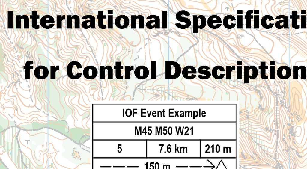


1 International Specification for Control Descriptions INTERNATIONAL ORIENTEERING FEDERATION 2018
2 INTERNATIONAL ORIENTEERING FEDERATION International Orienteering Federation Drottninggatan 47, 3 1/2 tr. SE Karlstad Sweden IOF RULES COMMISSION: David Rosen (chairman), Barry McCrae, Felix Büchi Editor: Barry Elkington Artwork based on the 1990 edition with additional drawings by Matthew Cook (2004, 2018). Map sections by Jukka Liikari. Layout: Pirjo Valjanen. IOF Control Descriptions Major Changes to the 2004 version: 1) Optional extra line showing the distance to the start triangle from the timed start. 2) New symbols introduced for Trench, Out of Bounds Area. 3) Changed symbols for Boulder, Boulder Cluster, Dot Knoll. 4) Bend moved from Column G to Column F. 5) Removal of symbol for Radio or TV control. 6) Names and descriptions brought into line with the ISOM 2017 terminology where appropriate. 7) Renumbering of symbols to cater for additions and deletions. 8) A number of minor changes throughout the text in order to provide further clarifi cation as to the use of specifi c symbols. 2 International Specifi cation for Control Descriptions
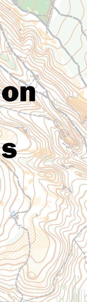
3 Introduction Orienteering is a worldwide sport. It is the aim of the IOF control description symbols to provide a standard means for orienteers from all countries to be able to understand control descriptions without ambiguity or the need for language translation. This booklet shows how the symbols can be used to do this. How IOF control descriptions work The purpose of a control description is to give greater precision to the picture given by the map of the control feature, and to indicate the location of the control fl ag in relation to this feature, thereby helping the competitor to better visualise the control site. However, a good control is found primarily by map reading. Descriptions and codes can assist in this task, but should be kept as short and simple as is necessary to locate the control. Note: Control descriptions should not be used to correct map errors. Sample control description sheet IOF Event Example Classes M45 M50 W21 Course number 5 Length 7.6 km Height climb 210 m Distance to Start Triangle 150 m Start Road, wall junction Narrow marsh bend North western boulder, 1m high, east side Between thickets Middle depression, east part Eastern ruin, west side Follow taped route 120 m away from control Stone wall, ruined, south east corner (outside) Spur, north west foot Upper cliff, 2m high Path crossing Follow taped route 250 m from last control to fi nish International Specifi cation for Control Descriptions
4 Control description sheet format The control description sheet for an orienteering course contains the following information: Heading. Start Location, including details of the distance to the start triangle from the point of the timed start if these are not within a few metres of each other. Description of individual controls, incorporating any special instructions such as the length and nature of any marked route during the course. Nature of route from the last control to the fi nish. When printed, the description sheet boxes should be square, with a side dimension of between 5mm and 7mm. When control descriptions are provided in a written form the overall presentation should be similar to that of the pictorial version, and the description of the individual controls written, as far as possible, in the same order as for the pictorial version. Heading Event title. Classes (optional line). Course code; Course length in kilometres to the nearest 0.1km, measured from the point at which the timing starts; Height climb in metres to the nearest 5m. Start location Shown in the fi rst line of descriptions, using the description as if it were a control feature. Optionally this may be preceded by a line showing the distance to the start triangle from the timed start if these are not within a few metres of each other. Description of individual controls These are normally in the order in which they are to be visited, and may incorporate special instructions such as the length and nature of any marked route during the course. A thicker horizontal line should be used after every third description and on either side of any special instruction. A B C D E F G H A B C D E F G H Control number Control code Which of any similar feature Control feature Appearance Dimensions / Combinations / Bend Location of the control flag Other information 4 International Specifi cation for Control Descriptions
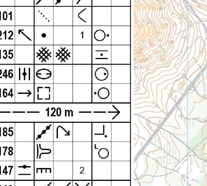
5 Explanation of Columns Each control is described in the following manner: Column A - Control number Numbering of controls is in the sequence they are to be visited, unless the description is for a Score competition in which case this column is usually either left blank or indicates the control value. Column B - Control code The control code should be a number greater than 30. Column C - Which of any similar feature This column may be used when there is more than one similar feature within the control circle; e.g. south eastern. Column D - Control feature The feature, as shown on the map, at the centre of the circle defi ning the control site; e.g. clearing; boulder. Most of these are cross referenced to the ISOM 2017 (International Specifi cation for Orienteering Maps) symbol used to represent them. Column E - Appearance Further information on the nature of the feature if it is required; e.g. overgrown; ruined. In certain circumstances also used for a second control feature where the description requires this i.e. crossing; junction; between. Column F - Dimensions / Combinations / Bend Dimensions of the feature should be given where the size of the control feature on the map is symbolic rather than to scale. Also used for the two combination symbols (crossing; junction), and the Bend symbol. Column G - Location of the control flag Position of the control fl ag with respect to the feature; e.g. west corner (outside); south foot. Column H - Other information Other information that may be of importance to the competitor; e.g. fi rst aid; refreshments. Special Instructions These lines go in the body of the descriptions and give specifi c information about the nature of the route that must be followed at that point; e.g. follow taped route for 50m away from the control; use mandatory crossing point. Nature of route from the last control to the Finish This line shows the distance from the last control to the fi nish, and the nature of any taped route at the fi nish. International Specifi cation for Control Descriptions


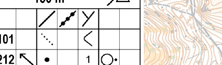
 Ref. Symbol Name Description ISOM 1.1 Terrace A level area on a slope. 101 1.2 Spur 1.")

6 Explanation of Symbols Where an ISOM reference number is given this shows the relationship to the map symbol as defi ned in the ISOM 2017 specifi cations. Column C - Which of any similar feature These symbols need only be used when required to clarify on which of several similar features the control banner is placed i.e. the features are close enough on the map such that the intended feature is not obvious. They are not required if, for example, a second feature lies near the edge of the control circle. Ref. Symbol Name Description 0.1 Northern 0.2 South Eastern 0.3 Upper 0.4 Lower 0.5 Middle Column D The Control Feature The more northern of two similar features, or the northern-most of several similar features. The more south eastern of two similar features, or the south-eastern-most of several similar features. Where the control feature is directly above a similar feature. Where the control feature is directly below a similar feature. Where the control feature is the middle one of a number of similar features. Column D indicates the feature on which the control banner is placed. If a second control feature is required (i.e. for crossing; junction; between) then this must go in column E. It is not permitted to place two symbols in Column D. Land forms (ISOM section 3.1) Ref. Symbol Name Description ISOM 1.1 Terrace A level area on a slope Spur 1.3 Re-entrant 1.4 Earth bank 1.5 Quarry A contour projection or nose rising from the surrounding ground. A contour indentation; a valley; the opposite of a spur. An abrupt change in ground level which can clearly be distinguished from its surroundings. Gravel, sand or stone working in fl at or inclined ground International Specifi cation for Control Descriptions

 A depression or hollow from which the ground rises on all sides. Shown on the map with contour lines.")

7 1.6 Earth wall 1.7 Erosion gully Hill 1.10 Knoll 1.11 Saddle Small erosion gully A narrow wall of earth projecting above the surrounding terrain; may be partially stone faced, usually man-made An erosion gully or trench, normally dry. 107 A small erosion gully or trench, normally dry. A high point. Shown on the map with contour lines A small obvious mound The low point between two higher points Depression Pit Small depression 1.15 Broken ground 1.16 Ant hill (termite mound) A depression or hollow from which the ground rises on all sides. Shown on the map with contour lines. A small, shallow, natural depression or hollow from which the ground rises on all sides. A pit or hole with distinct steep-sides. Usually man made. Used with symbol 8.6 to indicate a rocky pit. Clearly disturbed ground with features too small or too numerous to be mapped individually; including animal earths. The mound made by ants or termites Rock and boulders (ISOM section 3.2) Ref. Symbol Name Description ISOM 2.1 Cliff, Crag 2.2 Rock Pillar A cliff or rock face. May be passable or impassable A high, natural rock projection Cave 2.4 Boulder A hole in a rock face or hill side, often leading to underground workings. A prominent free-standing block of rock or stone International Specifi cation for Control Descriptions

 Ref. Symbol Name Description ISOM 3.1 3.2 3.3 Lake Pond A large area of water, normally mapped as uncrossable.")
8 2.5 Boulder fi eld 2.6 Boulder cluster 2.7 Stony ground 2.8 Bare rock 2.9 Narrow passage 2.10 Trench An area covered by so many boulders that they cannot be individually mapped. A small distinct group of boulders so closely clustered together that they cannot be individually mapped. An area covered with many small stones or rocks. A runnable area of rock with no earth or vegetation cover. A gap between two cliffs or rock faces that face each other A rocky or artifi cial trench. 215 Water and marsh (ISOM section 3.3) Ref. Symbol Name Description ISOM Lake Pond A large area of water, normally mapped as uncrossable. A small area of water, may be shallow or seasonable Waterhole A water-fi lled pit or depression River, Stream, Watercourse A natural or artifi cial watercourse with either moving or standing water Minor water channel, Ditch A natural or man made minor water channel which may contain water only intermittently Narrow marsh A narrow marsh or trickle of water, too narrow to be shown on the map with the marsh symbol Marsh A permanently wet area with marsh vegetation Firm ground in marsh A non-marshy area within a marsh, or between two marshes Well A shaft containing water or a captive spring, clearly visible on the ground. Often with some form of man-made surround International Specifi cation for Control Descriptions

9 Spring Water tank, Water trough The source of a watercourse with a distinct outfl ow. 312 A man made water container. 311 Vegetation (ISOM section 3.4) Ref. Symbol Name Description ISOM Open land Semi-open land Forest corner Clearing Thicket Linear thicket Vegetation boundary An area with no trees. Grassland, a meadow or a fi eld. Also heath or moorland. An area of open land with scattered trees or bushes. The corner or tip of a forested area projecting into open land. A small area of land free from trees within the forest. A small area of forest where the tree cover or undergrowth is so dense that it is diffi cult to pass. May also be used for an individual bush (typically in Sprint competitions). A man-made line of trees or bushes that is diffi cult to cross. May also be used for a hedge (typically in Sprint competitions). A distinct boundary between different types of trees or vegetation Copse A small area of trees in open ground Prominent tree Root stock, Tree stump An unusual or prominent tree in either open land or forest; frequently information is also given as to its type. The upturned root of a fallen tree, with or without the trunk. The stump of a tree International Specifi cation for Control Descriptions

10 Man-made features (ISOM section 3.5) Ref. Symbol Name Description ISOM Road Track / Path Ride Bridge Power line Power line pylon A metalled/asphalt surfaced or dirt road, suitable for vehicles in normal weather conditions. A visible route made by people or animals. Tracks may be driven by rugged vehicles. A clearly visible linear break in the forest which does not have a distinct path along it. A crossing point over a watercourse or other linear feature. A power or telephone line, cableway or ski lift. A support for power or telephone line, cableway or ski lift Tunnel A way under roads, railways, etc Stone wall Fence Crossing point A stone boundary wall or stone faced bank. Used with symbol 8.11 to indicate a ruined stone wall. A wire or wooden boundary. Used with symbol 8.11 to indicate a ruined fence. A way through or over a wall, fence, or other linear feature, including a gate or stile Building A standing brick, wood or stone structure Paved area An area of hard standing used for parking or other purposes Ruin The remains of a building that has fallen down Pipeline A prominent line feature such as a pipeline (gas, water, oil, etc.) above ground level Tower A tall metal, wooden or brick structure, usually built for forest observation Shooting platform A structure attached to a tree where a marksman or observer can sit International Specifi cation for Control Descriptions
11 Boundary stone, Cairn A man made stone or pile of stones. A cairn, memorial stone, boundary stone or trigonometric point. 526 Fodder rack A construction for holding feed for animals Charcoal burning ground Platform Monument or Statue Canopy Stairway The clear remains of an area where charcoal was burned. A small level man made area on a slope. (A platform) A monument, memorial or statue An accessible area with a roof. A canopy or a covered passageway through a building. A stairway of at least two steps Out of Bounds area Out of Bounds area. Typically a fl ower bed or similar feature. 520 Special features Ref. Symbol Name Description ISOM Special item Special item If used, an explanation of its meaning must be supplied to competitors in the pre-race information. If used, an explanation of its meaning must be supplied to competitors in the pre-race information. Country Specific features It is not generally recommended to introduce local symbols. At events likely to attract an international entry, if local symbols are used then information about them must be supplied to competitors in the pre-race details. Ref. Symbol Name Description ISOM 7.n Name Description of feature. International Specifi cation for Control Descriptions


12 Column E - Appearance These symbols can be used when required to add clarity to the map in order to allow the competitor to better visualise the control site. Ref. Symbol Name Description Low Shallow Deep Overgrown Open Rocky, Stony Marshy Sandy Needle leaved Broad leaved Ruined Where the control feature is particularly low or fl at but this is not indicated on the map; e.g. Hill, low. Where the control feature is particularly shallow but this is not indicated on the map; e.g. Re-entrant, shallow. Where the control feature is particularly deep but this is not indicated on the map; e.g. Pit, deep. Where the feature is partially covered in undergrowth or bushes that are not indicated on the map; e.g. Ruin, overgrown. Where the feature is in an area where the tree cover is less than the surroundings but this is not indicated on the map; e.g. Marsh, open. Where the feature is in an area of rocky or stony ground not indicated on the map; e.g. Pit, rocky. Where the feature is in an area of marshy ground not indicated on the map; e.g. Re-entrant, marshy. Where the feature is in an area of sandy ground not indicated on the map; e.g. Spur, sandy. Where the tree or trees associated with the control feature have needle shaped leaves; e.g. Distinctive tree, needle leaved. Where the tree or trees associated with the control feature are broad-leaved; e.g. Copse, broad leaved. Where the feature has fallen to ground level; e.g. Fence, ruined. 12 International Specifi cation for Control Descriptions
13 Column F Dimensions / Combinations / Bend Dimensions Note: The dimension(s) of the feature(s) must be given when they add add clarity to the map in order to allow the competitor to better visualise the control site. e.g. from a visibility point of view it is important to know if a boulder is 1m high or 3m high. Ref. Symbol Name Description x 4 Height or Depth Size Height or Depth of the feature in metres. Horizontal dimensions of the feature in metres Height on slope Height of the feature on a slope in metres Heights of two features Heights of two features with the control between them. Combinations Ref. Symbol Name Description 10.1 Crossing The point at which two linear features cross Junction The point at which two linear features meet; or where a linear feature meets the side of an areal feature. When either of these symbols are used in Column F the two features which either cross or meet must be shown in columns D and E. For example: D E F Path crossing Ride / Stream crossing Road junction Stream / Narrow marsh junction Fence / Buidling junction The point at which two similar linear features cross. The point at which two different linear features cross. The point at which two similar linear features meet. The point at which two different linear features meet. The point at which a linear feature meets the side of an areal feature. International Specifi cation for Control Descriptions
14 Bend Ref. Symbol Name Description 11.1 Bend Used where a linear feature makes a smooth change of direction; e.g. Path bend; River bend. Column G - Location of the control flag Note: No symbol is required to describe the location of the control fl ag in relation to the feature if the control fl ag is positioned at, or as near as possible to, the centre of the feature (or the centre of the foot in the case of the cliff). Ref. Symbol Name Description North east Side South east Edge West Part East Corner (inside) South Corner (outside) South west Tip Used where the feature extends above the surface of the ground; e.g. Boulder, north east side; Ruin, west side. A control on the side of a feature will not usually be visible from the opposite side. Used where: a) The feature extends down from the surface of the surrounding ground and the control is situated on the edge at ground level; e.g. Depression, south east edge. b) The feature extends over a signifi cant area and the control is situated on the border of that area; e.g. Marsh, west edge; Clearing, north west edge. Used where the feature extends over a signifi cant area and the control is located neither at the centre, nor on any of the edges; e.g. Marsh, west part; Depression, south east part. Used where: a) The edge of a feature turns through an angle of degrees; e.g. Open land, east corner (inside); Ruin, north west corner (outside). b) A linear feature turns a corner; e.g. Fence, south corner (inside); Stone wall, south west corner (outside). Note: The side of a building may be treated as a linear feature and hence building, east corner (inside) does not mean inside the building. The orientation of the symbol indicates the direction in which the corner points. Used where the edge of a feature turns through an angle of less than 45 degrees; e.g. Marsh, south west tip. 14 International Specifi cation for Control Descriptions


15 North west End Upper Part Lower Part Top Foot (no direction) North east Foot Beneath Between The point at which a linear feature ends or starts; e.g. Ride, north west end; Stone wall, south end. Where the feature extends over two or more contours and the control is located near the top; e.g. Erosion Gully, upper part. Where the feature extends over two or more contours and the control is located near the bottom; e.g. Re-entrant, lower part. Where the control is located at the highest point of the feature and this is not the default location; e.g. Cliff, top; Stairway, top. Where the control is located at the lower junction of the slope of the feature and the surface of the surrounding area and this is not the default location; e.g. Earth bank, foot; Stairway, foot. As above, but where the feature is large enough for the control to be placed in more than one location around it; e.g. Hill, north east foot. Where the control is located underneath the feature; e.g. Pipeline, beneath. Where the control is located between two features; e.g. Between thickets; Between boulder and knoll. When symbol Between is used in Column G, the two features which the control is between must be shown separately in columns D and E. For example: D E F G Column H - Other information Between thickets Between boulder and knoll Ref. Symbol Name Description 13.1 First aid post The point between two similar features. The point between two different features. Control site where First aid is available Refreshment point Manned control Control site where Refreshments are available. Manned control site. International Specifi cation for Control Descriptions
16 Distance from Timed Start to the Start Triangle This is an optional line showing the distance to the start triangle from the point of the timed start. This will typically be required for an arena start. Ref Name/Description Distance to the start triangle from the point of the timed start. Special Instructions Special instructions may be given to the competitors within the body of the description sheet. These should be used to re-emphasise what is shown on the map. If a marked route is to be followed away from a particular control, or between controls: Ref Name/Description Follow Taped Route, 60m away from control. Follow Taped Route, 300m between controls. If there are mandatory crossing points or routes between two controls: Ref Name/Description Mandatory crossing point or points. Mandatory passage through out of bounds area. At a map exchange, or if a marked route is to be followed from a control to a map exchange, it should follow the last control description of the fi rst part of the course as follows: Ref Name/Description Follow Taped Route, 50m to Map Exchange. 16 International Specifi cation for Control Descriptions
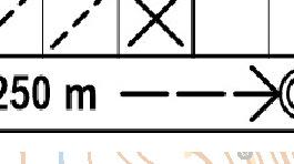
17 Nature of route from the last control to the Finish Following the fi nal description, the nature of the route from the last control to the fi nish is indicated by one of the following: Ref. Name/Description m from last control to Finish. Follow taped route. 150m from last control to Finish. Navigate to fi nish funnel, then follow tapes. 380m from last control to Finish. Navigate to fi nish. No tapes. International Specifi cation for Control Descriptions


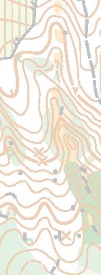
18 Examples Map Terrain Control Descriptions Text Description 1 Terrace 2 Terrace, west part 3 Spur 4 Spur, upper part 5 Spur 6 Re-entrant 7 Re-entrant, upper part 8 Re-entrant, shallow 18 International Specifi cation for Control Descriptions


19 Map Terrain Control Descriptions Text Description 9 Eastern re-entrant 10 Earth bank, foot 11 5x5 Quarry, 5m x 5m 12 Quarry, east edge 13 Quarry, east part 14 Earth wall, east end 15 Gully, lower part 16 Small gully, north-east end 17 Hill International Specifi cation for Control Descriptions


20 Map Terrain Control Descriptions Text Description 18 Hill, north-west part 19 West Hill, East side 20 Between hill and knoll 21 1 Knoll, 1m 22 1 Knoll, 1m, east foot 23 Saddle 24 Depression 25 Depression, east part 26 Middle small depression, east edge 27 Pit, west edge 20 International Specifi cation for Control Descriptions


21 Map Terrain Control Descriptions Text Description 28 Ant hill 29 2 Cliff, 2m 30 Cliff, north foot 31 2 Upper cliff, 2m 32 3 Cliff, 3m, top 33 Between cliffs 34 Rock pillar, south foot 35 Cave Boulder, 1.5m, west side International Specifi cation for Control Descriptions


22 Map Terrain Control Descriptions Text Description 37 2 South-eastern boulder, 2m, east side Between boulders 1m and 1.5m Boulder, 0.5m/3m, west side 40 Boulder fi eld, south-east edge 41 Boulder cluster, south side 42 Stony ground, north edge 43 Bare rock 44 Bare rock, west part 45 Narrow passage 22 International Specifi cation for Control Descriptions


23 Map Terrain Control Descriptions Text Description 46 Lake, east tip 47 Pond, east edge 48 Waterhole, east edge 49 Stream bend 50 Southern stream bend 51 Stream junction 52 Ditch, north-east end 53 Ditch bend 54 Northern ditch bend 55 Ditch junction International Specifi cation for Control Descriptions


24 Map Terrain Control Descriptions Text Description 56 Ditch crossing 57 Narrow marsh, south-east end 58 Marsh, north-west part 59 Marsh, south tip 60 Marsh, east edge 61 8x8 Marsh, 8m x 8m 62 Between marshes 63 Firm ground in marsh, north-west tip 64 Well, east side 24 International Specifi cation for Control Descriptions


 68")


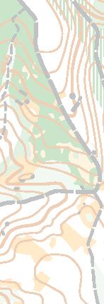
25 Map Terrain Control Descriptions Text Description 65 Spring, west edge 66 Water tank, east side 67 Open land, east corner (inside) 68 Open land, sandy west edge 69 Semi-open land, east edge 70 Forest corner, south tip 71 Clearing 72 Thicket, east side 73 Linear thicket, east corner (outside) International Specifi cation for Control Descriptions


26 Map Terrain Control Descriptions Text Description 74 Vegetation boundary, east corner outside) 75 Copse, west tip 76 Distinctive tree, broad leaved 77 Root stock, east side 78 Road, south-east end 79 Road junction 80 Road/path crossing 81 Path bend 82 Western path bend 26 International Specifi cation for Control Descriptions


27 Map Terrain Control Descriptions Text Description 83 Path junction 84 Path crossing 85 Path/stream crossing 86 Path/ditch crossing 87 Ride bend 88 Bridge, north end 89 Power line, pylon 90 Tunnel, south-west end 91 Wall, east corner (inside) International Specifi cation for Control Descriptions


28 Map Terrain Control Descriptions Text Description 92 Wall, ruined, west end 93 Stream/wall crossing 94 Path/wall crossing 95 Fence, south corner (outside) 96 Crossing point, south side 97 Building, east side 98 Ruin, west side 99 Pipeline, beneath 100 Tower, south side 28 International Specifi cation for Control Descriptions


29 Map Terrain Control Descriptions Text Description 101 Shooting platform 102 Cairn, east side 103 Fodder rock, west side 104 Charcoal burning ground 105 Statue 106 Canopy, southwest end 107 Stairway, foot Add two drawings for Trench and Flower Bed (Out of Bounds) International Specifi cation for Control Descriptions
30 Specifications for Trail Orienteering There are two variations in the use of the columns when using IOF Control Descriptions for Trail Orienteering. Column B - Number of control flags This column is used to denote the number of control fl ags visible at this control; e.g. A-C equals three control fl ags to choose from; A-D equals four control fl ags to choose from. Column H - Direction of observation This column is used to denote the direction in which to view a feature. For example an arrow pointing north indicates that the competitor should be on a path/track to the south of the control circle. Example A B C D E F G H 1 A-D 30 International Specifi cation for Control Descriptions
31 International Specifi cation for Control Descriptions
32 INTERNATIONAL ORIENTEERING FEDERATION INTERNATIONAL ORIENTEERING FEDERATION Drottninggatan 47, 3 1/2 tr. SE Karlstad Sweden Tel: +46 xxxxxxxxxxx Fax: +46 xxxxxxxxxxx iof@orienteering.org
Control Description Sheet 1
 Control Description Sheet 1 Headings I0A Example M20 M21 M35 1 8.8km 250m Event Title Classes (optional) Course Code; Course length, Height climb Start location as if it was a control. First Control Description
4.1 Landforms. Note: dimensions are specified in mm at the scale of 1: All drawings are at 1:7 500 for clarity only.
 4.1 Landforms Note: dimensions are specified in mm at the scale of 1:15 000. All drawings are at 1:7 500 for clarity only. OM = Outside measure IM = Inside measure CC = Centre to centre 0.2 0.4 OM 0.4
5 MAP SPECIFICATION FOR SKI-ORIENTEERING
 5 MAP SPECIFICATION FOR SKI-ORIENTEERING 5.1 General Maps for ski orienteering are based on the specifications for foot-orienteering maps. However in order to meet the specific requirements put on the
ISOM & ISSOM forbidden symbol comparison
 & forbidden symbol comparison Forbidden symbols and their relatives Symbol 2000 (Long, Middle) 2007 (Sprint) 201 Impassable cliff An impassable cliff, quarry or earth bank (see 106) is shown with a 0.35
International SpeciÞcation for Control Descriptions
 International SpeciÞcation for Control Descriptions INTERNATIONAL ORIENTEERING FEDERATION 2004 INTERNATIONAL ORIENTEERING FEDERATION Radiokatu 20, FIN-00093 SLU, Finland http://www.orienteering.org IOF
INTERNATIONAL ORIENTEERING FEDERATION 2010
 INTERNATIONAL ORIENTEERING FEDERATION 2010 Valid from 15 May 2010 1 INTRODUCTION Orienteering is a world-wide sport. A common approach to the interpretation and drawing of orienteering maps is essential
Camp Jack Wright PERMANENT ORIENTEERING COURSE (2004)
") Camp Jack Wright PERMANENT ORIENTEERING COURSE (2004) WHAT IS ORIENTEERING? The skill which enables a person to navigate with a map. In the competitive sport, the winner is the person who finishes in the
Camp Jack Wright PERMANENT ORIENTEERING COURSE (2004) WHAT IS ORIENTEERING? The skill which enables a person to navigate with a map. In the competitive sport, the winner is the person who finishes in the
International Specification for Sprint Orienteering Maps (ISSOM) Final draft IOF Map Commission 2004 FOREWORD
 Final draft IOF Map Commission 2004 FOREWORD") International Specification for Sprint Orienteering Maps (ISSOM) Final draft 004 FOREWORD The Map Commission within the International Orienteering Federation is responsible for all matters related to orienteering
International Specification for Sprint Orienteering Maps (ISSOM) Final draft 004 FOREWORD The Map Commission within the International Orienteering Federation is responsible for all matters related to orienteering
International Specification for Sprint Orienteering Maps (ISSOM) Final draft. IOF Map Commission 2003 FOREWORD
 Final draft. IOF Map Commission 2003 FOREWORD") FOREWORD International Specification for Sprint Orienteering Maps (ISSOM) Final draft The Map Commission within the International Orienteering Federation is responsible for all matters related to orienteering
FOREWORD International Specification for Sprint Orienteering Maps (ISSOM) Final draft The Map Commission within the International Orienteering Federation is responsible for all matters related to orienteering
MAPPING OF ROCK FEATURES 2.9
 MAPPING OF ROCK FEATURES 2.9 Introduction 1 The mapping of rock in recent years has been one of the strengths of orienteering in Australia. This has been largely because our granite terrain has presented
BURGHCLERE PARISH RIGHTS OF WAY
 BURGHCLERE PARISH RIGHTS OF WAY Full descriptions compiled by Neill & Miggie Bruce All photos Miggie Bruce FP23 on Ridgemoor, looking south, with FP22 crossing by the bush FP1. From C183 Aldern Bridge
Trail Phasing Plan. Note: Trails in the Clear Creek Canyon area (Segments will be finalized in the future to minimize wildlife impacts
 Note: Trails in the Clear Creek Canyon area (Segments 2 5 and a future JCOS connection) will be finalized in the future to minimize wildlife impacts Trail Phasing Plan P Parking 3 Easy Trail Intermediate
Below is an example of a well laid-out template of a route card used by the Sionnach Team which is a good format to begin with.
 Route Card A route card is used as a navigational aid to hill walkers by setting out a step by step plan for an intended hike. It is good practice to make out a route card before every hike you or your
OA Sprint mapping workshop Ballarat, 1 Oct Andrew Lumsden
 OA Sprint mapping workshop Ballarat, 1 Oct 2015 Andrew Lumsden Choosing an area Look at aerial photos (Google maps or better) Walk or jog around Look for potential problems: traffic, access issues Assess
Orienteering. The fundamental outdoors skill!
 The fundamental outdoors skill! Orienteering Nothing will make you feel more confident in the out of doors like knowing how to find your way in the woods. Orienteering Prepared by: Jeffrey Lybarger Assistant
LAKE NEEDWOOD ORIENTEERING MEET QUANTICO ORIENTEERING CLUB SEPTEMBER 18, 2011
 NATIONAL ORIENTEERING DAY LAKE NEEDWOOD ORIENTEERING MEET QUANTICO ORIENTEERING CLUB SEPTEMBER 18, 2011 COMBINED EVENT NOTES, including: National Orienteering Day Course Designer s Notes Super String-O
Wicklow Mountains Path Survey
 Wicklow Mountains Path Survey Glenmacnass Tonelagee Start to Finish: O 114 030 to O 085 016 Altitude (lowest highest): 370m 817m Weather: Sunny day, hot Access: Military Road, Glenmacnass Surveyed by:
CWMGIEDD FROM ABERCRAVE
 Abercrave to Cwmgiedd Walk Page 1 Starting from The Abercrave Inn. Grid Ref: SN 824128 From the Abercrave Inn, an 11.3km (7 miles) walk to the foothills of the Cribarth Mountain, then through forest to
The Atlas of Hillforts of Britain and Ireland. Hillfort survey notes for guidance
 The Atlas of Hillforts of Britain and Ireland Hillfort survey notes for guidance The collection of surveys for the Atlas is now finished but you can use this form and the accompanying Notes for Guidance
FOUNDATIONS OF ARCHAEOLOGY A WALK IN VERNDITCH CHASE
 FOUNDATIONS OF ARCHAEOLOGY A WALK IN VERNDITCH CHASE 1. A Tale of two Long Barrows Long barrows were constructed as earthen or drystone mounds with flanking ditches and acted as funerary monuments during
K SIGNAGE & TRAFFIC CONTROL. Table of Contents
 Table of Contents K1. ACCOMMODATION OF TRAFFIC... 1 K2. MINIMUM CONSTRUCTION SIGNING... 1 K3. SUBDIVISION SIGNS... 2 K4. TRAFFIC CONTROL DEVICES... 2 K4.1 Traffic Signs Regulations... 2 K4.2 Materials...
Leaden Boot Challenge ROUTE INSTRUCTIONS
 Leaden Boot Challenge ROUTE INSTRUCTIONS Section 1 Alstonefield to Ilam From the village hall car park turn R then L and pass through the village keeping to the R to enter Church Street. Pass the Church
General Considerations For Cross Country Orienteering Courses: Design and Set Guidelines
 General Considerations For Cross Country Orienteering Courses: Design and Set Guidelines Objective Orienteering's slogan is that it is "the thinking sport." Doing well requires a combination of physical
Erskine Creek via Pisgah Rock and Jack Evans
 Erskine Creek via Pisgah Rock and Jack Evans 4 hrs 30 mins 7.1 km Circuit Very experienced only 6 421m This walk visits some great lookouts and explores the lower section of Erskine Creek. Most of the
Leaden Boot Challenge 2016 ROUTE INSTRUCTIONS
 Leaden Boot Challenge 2016 ROUTE INSTRUCTIONS Section 1 Alstonefield to Ilam (CP2) From the village hall car park turn R then L and pass through the village keeping to the R to enter Church Street. Pass
Introduction to Topographic Maps
 Introduction to Topographic Maps DIRECTIONS: Read all of the following content. READ EVERYTHING!! At the end of the packet, you will find two topographic maps. Your task is to indentify each of the elevations
HARDMOORS 55 RACE ROUTE 2018 HELMSLEY - GUISBOROUGH
 HARDMOORS 55 RACE ROUTE 2018 HELMSLEY - GUISBOROUGH HELMSLEY - CHECKPOINT 1 (WHITE HORSE) 1. Leave RACE START, continue ahead on road (Baxtons Sprunt) At crossroads turn right down Canons Garth eventualy
APPENDIX D: SUSTAINABLE TRAIL DESIGN. APPENDICES Town of Chili Parks and Recreation Master Plan Update
 APPENDIX D: SUSTAINABLE TRAIL DESIGN APPENDICES Town of Chili Parks and Recreation Master Plan Update Sustainable Trail Construction Sustainable trails are defined by the US Forest Service as trails having
IMPORTANT DEFINITIONS DEFINITIONS FROM TOPO MAPS
 IMPORTANT DEFINITIONS DEFINITIONS FROM TOPO MAPS 1. REPRESENTATIVE FRACTION (RF): It is the ratio between the distances on the map to its corresponding distance on actual ground. The RF on this map is
Girrakool to Wondabyne station via Pindar caves
 Girrakool to Wondabyne station via Pindar caves 7 hrs 30 mins 18.1 km One way Experienced only 5 741m This walk starts from the Girrakool picnic area and winds south, following Piles creek into the Brisbane
KP Lasnaya 1 River
 KP 370.2 Lasnaya 1 River The Lasnaya 1 River crossing is protected by Reno mattings and a gabion wall on the north bank (Photo 1). The south bank consists of natural river gravel deposits on top of Reno
Dadder Cave and Jack Evans track
 Dadder Cave and Jack Evans track 2 Days 10.3 km Circuit Very experienced only 535m This fairly short overnight walk is a great way to explore Erskine Creek. The walking along Erskine creek is mostly off
Looking north from the SW shieling site with Lub na Luachrach in the foreground
 Looking north from the SW shieling site with Lub na Luachrach in the foreground Upper Gleann Goibhre - Shieling sites Two shieling sites in the upper reaches of the Allt Goibhre were visited and recorded
Self-Guided Walk Langdale Pikes. Start & Finish: NT car park (free to members) at Sticklebarn - on the right just beyond the New Dungeon Ghyll hotel.
 at Sticklebarn - on the right just beyond the New Dungeon Ghyll hotel.") Self-Guided Walk Langdale Pikes Key Information These mountains form a collection of spires and cliffs on the north side of Langdale. This walk visits four of the main tops Pavey Ark, Harrison Stickle,
Self-Guided Walk Langdale Pikes Key Information These mountains form a collection of spires and cliffs on the north side of Langdale. This walk visits four of the main tops Pavey Ark, Harrison Stickle,
European Youth Orienteering Championships June 1 July Bulletin 2.
 European Youth Orienteering Championships 2018 28 June 1 July 2018 Bulletin 2 Sponsors Partners Become a sponsor or a partner for EYOC 2018 Write to us for more information Organizers 2 Organizers Contacts
TRIP PARTICIPANT LIST
 TRIP LEADER FORMS TRIP PARTICIPANT LIST Complete this form for all advertised club trips with copies to the club Trip Coordinator prior to the trip. Trip Name Location(s) Date(s) Trip Leader Ground Charlie
Property access tracks
 Property access tracks Planning, location, construction and maintenance The need for farm roads and tracks The efficient running of a property depends on, among other things, ready access to various locations
BUS 2 1. Introduction 2. Structural systems
 BUS 2 1. Introduction 2. Structural systems 3. Staircases terminology, requirements 4. Staircases structures, historic review 5. Staircases 6. Expansion joints 7. Foundations terminology 8. Foundations
Girrakool to Wondabyne station
 Girrakool to Wondabyne station 4 hrs Hard track 9.5 km One way 4 438m This walk starts from the Girrakool picnic area and winds south, through the Brisbane Waters National Park. The walk crosses some long
Congewai Track Head (East) to Watagan Headquarters
 to Watagan Headquarters") Congewai Track Head (East) to Watagan Headquarters 7 hrs Hard track 17.2 km One way 4 973m This full day walk starts from the Congewai valley trackhead (east) and follows the Great North Walk up into the
Congewai Track Head (East) to Watagan Headquarters 7 hrs Hard track 17.2 km One way 4 973m This full day walk starts from the Congewai valley trackhead (east) and follows the Great North Walk up into the
The Mendip Way. Route Directions and Maps Uphill to Wells
 The Mendip Way Route Directions and Maps Uphill to Wells Website: www.mendiphillsaonb.org.uk Email: mendip@mendiphillsaonb.org.uk Facebook & Twitter: @MendipHillsAONB Phone: 01761462338 1 Uphill to Loxton
10 th World Rogaining Championships 2012 Organizers' Report
 10 th World Rogaining Championships 2012 Organizers' Report August 2012 Our WRC 2012 course is virtually planned; all the checkpoints have been marked and inspected by vetters. All of them say everything
The Appleton Wetland; Its Decline, Cause and Recommended Action. Appendix K: Wetland Inspection
 The Appleton Wetland; Its Decline, Cause and Recommended Action Appendix K: Wetland Inspection Report prepared by Appleton Wetland Research Group of the Mississippi Valley Field Naturalists Research Group
Hindhead, Keffolds Copse and Gibbet Hill
 point your feet on a new path, Keffolds Copse and Gibbet Hill Distance: 6 km=4 miles Region: Surrey Author: Schwebefuss Refreshments: Punch Bowl Café moderate walking Date written: 14-apr-2015 Last update:
Route #2) Mt. Massive - Southwest Slopes
 Mt. Massive - Southwest Slopes") Route #2) Mt. Massive - Southwest Slopes Difficulty: Class 2 Ski: Advanced, D6 / R2 / III Exposure: Summit Elevation: Trailhead Elevation: Elevation Gain: Round-trip Length: Trailhead: County Sheriff:
Route #2) Mt. Massive - Southwest Slopes Difficulty: Class 2 Ski: Advanced, D6 / R2 / III Exposure: Summit Elevation: Trailhead Elevation: Elevation Gain: Round-trip Length: Trailhead: County Sheriff:
Wicklow Mountains Path Survey
 Wicklow Mountains Path Survey Ballinacor Croaghanmoira Fananierin Start to Finish: T 11723 86602 to T 11175 89057 Altitude (lowest highest): 385m 664m Weather: Hot Access: Coolgarrow forest entrance Surveyed
Lake Wissota Access Locations within the LaFayette Township. By Chad Martin
 Lake Wissota Access Locations within the LaFayette Township By Chad Martin Anson/ Wissota Access Point # 1 Road: 195 th St. Associated Fire Numbers: 13294 Defining Characteristics: Forested from road
Figure 1 Understanding Map Contours
 Figure 1 Understanding Map Contours The light brown lines overprinted on topographic maps are called contour lines. They indicate the elevation above sea level of land features and thus permit you to view
Orientation Booklet The New Airline Chart Series
 Orientation Booklet The New Airline Chart Series Copyright 2007 Jeppesen. All rights reserved. Table of Contents Introduction...1 Approach Chart...2 Heading...2 Plan View...2 Profile View... Minimums...
Approximate distance: 5.5 miles For this walk we ve included OS grid references should you wish to use them. Start. End
 Approximate distance: 5.5 miles For this walk we ve included OS grid references should you wish to use them. Start End 2 1 5 4 6 3 N W E 7 S Reproduced by permission of Ordnance Survey on behalf of HMSO.
Evaluation Report 569
 Printed: March 1988 Tested at: Lethbridge ISSN 0383-3445 Group Evaluation Report 569 Vern Seed Boot and Banding Knife A Co-operative Program Between ALBERTA FARM MACHINERY RESEARCH CENTRE PAMI PRAIRIE
Beautiful Walks from the Blue Ball Inn
 Walk No. 5 RIVER VALLEYS AND MOOR Countisbury, Watersmeet, Hillsford Bridge, Cheriton, Shilstone Hill, Rockford and Chiselcombe. 8.5 MILES APPROX. Walking time four and a half hours approx. OS 1;25,000
Note: Coordinates are provided as Universal Transverse Mercator UTM Zone U21, North American Datum 1983 (NAD 83).
.") Northern Traverse Route Description The Northern Traverse (formerly the North Rim Traverse) is an unmarked and rugged backcountry hiking route. It is known be a demanding hike, because of its terrain and
Northern Traverse Route Description The Northern Traverse (formerly the North Rim Traverse) is an unmarked and rugged backcountry hiking route. It is known be a demanding hike, because of its terrain and
SLOPE CALCULATION. Wilderness Trekking School 1
 SLOPE CALCULATION By Joe Griffith, February 2014 Objectives Upon completion of this chapter, you will be able to: Read the rise-over-run from a topographic map. Convert the rise-over-run into a slope angle
Prior to contacting the Whitecourt Trailblazers Snowmobile Club, applicants must:
 WHITECOURT TRAILBLAZERS Box 607 Whitecourt, AB T7S 1N7 www.whitecourttrailblazers.ca CNT AMENDMENT Restriction Code 710: See Comments Comments All applicants are required to contact: Whitecourt Trailblazers
Scenic Railway to Ruined Castle
 Scenic Railway to Ruined Castle 7 hrs 30 mins 12.4 km Return Hard track 4 963m This is a very popular, full day walk, in the Katoomba Area, offering great views of the valley. The walk follows the edge
ORIENTEERING. Allestree Park - Permanent Orienteering Course
 ORIENTEERING Allestree Park - Permanent Orienteering Course This pack consists of a map and this explanatory leaflet incorporating the control description list. The courses start at the car park on the
COWAL WAY MULTI-USE ACCESS NOTES
 COWAL WAY MULTI-USE ACCESS NOTES The Cowal Way is a 57 mile long distance path. Starting at Portavadie, it winds its way up through the Cowal peninsula via Tighnabruich, Glendaruel, Strachur, Lochgoilhead
Coast Path Survey Stretch 09 Shalfleet Mill to Thorness Bay
 Coast Path Survey Stretch 09 Shalfleet Mill to Thorness Bay Overview Map of stretch Introduction This stretch of Island coast covers several salt marsh creeks backed by grazing land and woodland on the
Attachment G STREAM IMPACTS. Ridge Road Extension Alternatives Analysis
 Attachment G STREAM IMPACTS for: Ridge Road Extension Alternatives Analysis PREPARED FOR: Pasco County Engineering Services Department PREPARED BY: NV5, INC. 6989 E. FOWLER AVENUE TAMPA, FLORIDA 33617
Baggy Point, Croyde, North Devon
 Baggy Point, Croyde, North Devon A walk using the South West Coast Path that is likely to be suitable for people with impaired mobility or with a pushchair, wheelchair, or mobility scooter. The Coast Path
Survey of Deadwater Fell and Peel Fell
 4 December 2014 Survey of Deadwater Fell and Peel Fell Team: John Barnard, Chris Crocker, Richard Cooper and Graham Jackson 1) Introduction Deadwater Fell (Hill 3542, Section 33, OS 1:50000 Map 80, OS
MUNICIPALITY OF MURRYSVILLE Policy # 20-05
 MUNICIPALITY OF MURRYSVILLE Policy # 20-05 04/11/05 SPECIFICATIONS FOR CONSTRUCTION AND MAINTENANCE MANUAL FOR HIKING, BICYCLING AND CROSS-COUNTRY SKIING TRAILS 1. INTRODUCTION This document provides guidelines
Mt Kuring-gai Track to Berowra station
 Mt Kuring-gai Track to Berowra station 4 hrs 15 mins 9.7 km One way Hard track 4 553m This walk explores three valleys, with great displays of wild flowers in spring, and some nice sandstone overhangs.
Registry Publication 15
 1. Display information The Display of Nationality and Registration Marks on Aircraft Article 10 of the Air Navigation (Isle of Man) Order 2015 requires Isle of Man registered aircraft regardless of size
User Guide. Building networks. Online application. exporeal.net
 User Guide Online application exporeal.net 22nd International Trade Fair for Property and Investment October 7 9, 2019 Messe München Building networks User Guide Simply convenient: Apply as an exhibitor
Consideration will be given to other methods of compliance which may be presented to the Authority.
 Advisory Circular AC 139-10 Revision 1 Control of Obstacles 27 April 2007 General Civil Aviation Authority advisory circulars (AC) contain information about standards, practices and procedures that the
INTERNATIONAL STANDARDS
 Annex or Recommended Practice INTERNATIONAL STANDARDS DEFINITIONS When the following terms are used in the s for Aircraft Nationality and Registration Marks, they have the following meanings: Civil Aviation
General Summer and Winter Views
 ENVIRONMENTAL INFORMATION REPORT VOLUME 4 APPENDIX 11. 2 General Summer and Winter Views Table of Contents Section APPENDIX 11.2 Page 1 General Views... 1-1 Tansy Lane, Portishead... 1-2 Galingale Way,
Victoria Falls and Grose Valley to Blackheath Station
 This walk explores a fantastic section of the Grose Valley. Starting above Victoria Falls, the walk explores the cascades before dropping into the valley for the first nights rest at Burra Korain campsite.
Lidar Imagery Reveals Maine's Land Surface in Unprecedented Detail
 Maine Geologic Facts and Localities December, 2011 Lidar Imagery Reveals Maine's Land Surface in Unprecedented Detail Text by Woodrow Thompson, Department of Agriculture, Conservation & Forestry 1 Introduction
ATVANS Trail Assessment for Five Bridge Lakes Wilderness Area Report and Recommendation. December 28, Prepared by.
 ATVANS Trail Assessment for Five Bridge Lakes Wilderness Area Report and Recommendation December 28, 2011 Prepared by Peter Bush Background This report documents the results and recommendations of an all-terrain
Staples Lookout to Mt Wondabyne loop
 Staples Lookout to Mt Wondabyne loop 4 hrs 3 mins 1.8 km Circuit Hard track 337m This walk starts and finishes at Staples Lookout, on Woy Woy Rd. The walk follows sections of the Great North Walk around
GRINDLEFORD GALLOP 2018
 GRINDLEFORD GALLOP 2018 Route Information The Grindleford Gallop follows a fixed 21 mile route through the lanes and paths of Derbyshire. All competitors must follow this route. An OS map of the area with
Pen Cerrig-calch prehistoric cairns
 Walk Information: Maps: OS Explorer OL13 Distance: 8 miles / 13 kilometres Duration: Allow at least 6 hours for the circular walk Difficulty: medium. Some narrow paths, occasionally rough underfoot Start
Ardingly Lake, Ouse Valley, Borde Hill
 point your feet on a new path Ardingly Lake, Ouse Valley, Borde Hill Distance: 14 km=9 miles or 12½ km=8 miles Region: West Sussex Author: Hautboy Refreshments: Borde Hill Map: Explorer 135 (Ashdown Forest)
beach. Make the ford and follow the trail out to the junction with Red Creek Tr in an open grassy area.
 Description: This is a moderate to slightly strenuous 22.8 mile backpack (add 2.6 miles if you do the packless out and back to the Lion s Head) that will have you exploring nearly every thing that is The
Access Statement for RSPB Lochwinnoch
 Introduction This access statement does not contain personal opinions as to our suitability for those with access needs, but aims to accurately describe the facilities and services that we offer all our
Chapter Five. Schedule 0.21: Particulars of Slum
 Schedule 0.21: Particulars of Slum 5.0 Introduction: The first nationwide survey on the economic condition of slum dwellers in urban cities was conducted by the NSSO in its 31 st round (July 1976 - June
IFR SEPARATION WITHOUT RADAR
 1. Introduction IFR SEPARATION WITHOUT RADAR When flying IFR inside controlled airspace, air traffic controllers either providing a service to an aircraft under their control or to another controller s
This path goes past an old tree nursery and sawmill. After 800m it crosses over a lane. Follow the bridleway fingerpost into the woods.
 FRENSHAM PONDS 11K CIRCULAR TRAIL 2½ HRS GU10 2DA This magnificent heathland trail starts in woodland and then brings you out onto the open heather of Frensham Common, with no roadwork! The route runs
Sponsored by. statestreet.com
 /STATESTREETISLANDWALK #ISLANDWALKJSY Sponsored by statestreet.com Important Information If you forget everything else PLEASE remember the following.» Remember to check OUT of every checkpoint» If you
Kuruwita Erathna Trail to Sri Pada (Adam s Peak)
") Kuruwita Erathna Trail to Sri Pada (Adam s Peak) Trail Difficulty: Easy Moderate Strenuous Tough Trail Head: Adevikanda, Erathna (near entrance to mini-hydro power plant) Nearest Town: Erathna Nearest
Kuruwita Erathna Trail to Sri Pada (Adam s Peak) Trail Difficulty: Easy Moderate Strenuous Tough Trail Head: Adevikanda, Erathna (near entrance to mini-hydro power plant) Nearest Town: Erathna Nearest
Bewl Water & the High Weald
 1 Bewl Water & the High Weald Stonegate station - Stonegate - Wallcrouch - Newbarn - Cousley Wood - Wood's Green - Wadhurst station Length: 9 ½ miles (15.3km) Underfoot: Large portions of this path are
A D V E R T I S I N G O P P O R T U N I T I E S W I T H IOF EVENTOR
 A D V E R T I S I N G O P P O R T U N I T I E S W I T H O IOF EVENTOR R E A C H T H E W O R L D S O R I E N T E E R I N G F A N S IOF offer its partners the best opportunity to reach the world s orienteers
Survey of Littleton Down
 Survey of Littleton Down 05 November 2014 The Team: John and Jenny Barnard 1) Introduction Littleton Down (Hill Number 2911, Section 42, OS 1:50000 Map 197, OS 1:25000 Map 121, Grid Ref. SU941150) is listed
Standard waymarked path grading system for Scotland
 Standard waymarked path grading system for Scotland Version 2 July 2015 FOR A HAPPIER, HEALTHIER SCOTLAND Contents Contents Why we need a grading system 3 A Six Part System 4 1. Path Name 5 2. Path Promotion
NAVIGATION: CHARTS, PUBLICATIONS, FLIGHT COMPUTERS (chapters 7 & 8)
") NAVIGATION: CHARTS, PUBLICATIONS, FLIGHT COMPUTERS (chapters 7 & 8) LONGITUDE AND LATITUDE 1. The location of an airport can be determined by the intersection of lines of latitude and longitude. a. Lines
NAVIGATION: CHARTS, PUBLICATIONS, FLIGHT COMPUTERS (chapters 7 & 8) LONGITUDE AND LATITUDE 1. The location of an airport can be determined by the intersection of lines of latitude and longitude. a. Lines
Flammability of Interior Materials
 TECHNICAL STANDARDS DOCUMENT No. 302, Revision 0R Flammability of Interior Materials The text of this document is based on Federal Motor Vehicle Safety Standard No. 302, Flammability of Interior Materials,
Eskdale Granite Bouldering Copyright Philip Wake
 Eskdale Granite Bouldering Copyright Philip Wake Directions (from the south) From the M6 motorway leave at junction 36 for Kendal/Lakes. Follow signs for Barrow. Before you reach Barrow, turn right to
INTRODUCTION. Mailing address: Burke County Community Development Attn: Tim Johnson P. O. Box 219 Morganton, NC
 REQUEST FOR QUALIFICATIONS: PROFESSIONAL, EXPERIENCED TRAIL BUILDERS FOR THE CONSTRUCTION OF THE FONTA FLORA STATE TRAIL LAKE JAMES SECTION BURKE COUNTY COMMUNITY DEVELOPMENT INTRODUCTION Burke County
INSTRUCTION SHEET DETHATCHER KIT. STS-422LX LPSTS-42JD Assembly Installation Operation Repair Parts L-1660-D. Visit us on the web!
 INSTRUCTION SHEET DETHATCHER KIT MODEL: DK-422LX FOR USE WITH SWEEPER MODEL: STS-422LX LPSTS-42JD Assembly Installation Operation Repair Parts For use with Riders and Lawn/Garden Tractors For the latest
CRAZY HORSE TRAIL GUIDE
 CRAZY HORSE TRAIL GUIDE Abridged Version: July 2016 This is a short form of our interpretive trail guide for the Crazy Horse Trail. The full version of the guide has a more detailed description of the
Hiking Trail Descriptions
 Hiking Trail Descriptions For ye shall go out with joy. And be led forth with peace. The mountains and the hills shall break forth before you in singing. And all the trees of the fields shall clap their
Region 1 Piney Woods
 Region 1 Piney Woods Piney Woods 1. This ecoregion is found in East Texas. 2. Climate: average annual rainfall of 36 to 50 inches is fairly uniformly distributed throughout the year, and humidity and temperatures
Victoria Falls Lookout to Blue Gum Forest
 Victoria Falls Lookout to Blue Gum Forest 8 hrs Experienced only 13.8 km One way 5 112m This long day-walk follows a remote track down from Victoria Falls lookout, passing the waterfall, and into the Grose
ADVERTISING OPPORTUNITIES WITH IOF EVENTOR R EACH THE WORLD S ORIENTEERING FANS
 ADVERTISING OPPORTUNITIES WITH O IOF EVENTOR R EACH THE WORLD S ORIENTEERING FANS IOF offer its partners the best opportunity to reach the world s orienteers and orienteering fans online Access to an exciting
Class F3K Hand Launch Gliders 5.7. CLASS F3K - HAND LAUNCH GLIDERS
 Class F3K Hand Launch Gliders 5.7. CLASS F3K - HAND LAUNCH GLIDERS 5.7.1. General This event is a multitasking contest where RC gliders must be hand-launched and accomplish specific tasks. In principle
Risk assessment for Foundation & KS1. Habitat & river activities at Rushall Farm 14 th January 2012
 Risk assessment for Foundation & KS1. Habitat & river activities at Rushall Farm 14 th January 2012 SITE NAME: Rushall farm GRID REF: SU 589 726 OWNER: W. Cumber & son (Theale) Ltd TEL. NO: 0118 9744 547
DD FORM 3009, FEB 2016 REPLACES DA FORM 1247, WHICH IS OBSOLETE. Page 1 of 6 Pages Adobe Professional X
 ROUTE CLASSIFICATION For use of this form, see ATP 3-34.81/MCWP 3-17.4; the proponent agency is TRADOC. SECTION I 1. SERIAL NUMBER 2. TO 3. FOR INFORMATION 4. DATE/TIME GROUP 5. NUMBER OF SHEETS OR ENCLOSURES