Introduction to Topographic Maps
|
|
|
- Gloria Nichols
- 6 years ago
- Views:
Transcription

 is the main distributor of topographic maps. The USGS creates several scales of maps. 7.5 minute maps (scale 1:24000) are the most detailed.")
1 Introduction to Topographic Maps DIRECTIONS: Read all of the following content. READ EVERYTHING!! At the end of the packet, you will find two topographic maps. Your task is to indentify each of the elevations at the letters A thru J. Write them in your notebook. A topographic map shows the elevation data for a certain part of the earth, in addition to other physical and man-made features. In the U.S., the United States Geological Survey (USGS) is the main distributor of topographic maps. The USGS creates several scales of maps. 7.5 minute maps (scale 1:24000) are the most detailed. All map samples shown below are from 7.5' maps. Above is a small part of a USGS map. 7.5 minute maps are so called because each covers 7.5 minutes of latitude and 7.5 minutes of longitude on the earth's surface. On the ground, this is approximately equal to eight miles (north and south) by six miles (east and west). Each 7.5' paper map (called a quadrangle, or just a quad) is about 28 inches long by 21 inches wide.

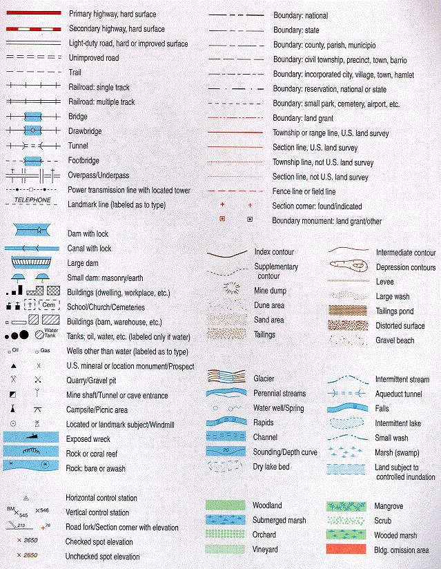
2 Reading map symbols Before getting into contours, take a look at the map above. Topographic maps also show many cultural and physical features. Some of the more common map symbols are labeled. Here are explanations for the non-contour symbols shown above: Forest: Shown in green Unforested areas: White; May be grass, sand, or some other surface Roads: Two parallel lines; Unbroken lines indicate paved roads, broken lines unpaved Trails: Dashed lines Streams and Rivers: Thin lines for streams, large blue area (actual scale size and shape) for larger rivers Marshy Area: Blue symbols enclosed by blue dashed line Buildings: Building shapes shown, may be filled or unfilled UTM Grid Lines: Especially useful for GPS, each grid square is 1 km x 1 km On the following page is a key of all of the symbols and features you will find on any USGS or other official topographic map.
3
 in the map above.")
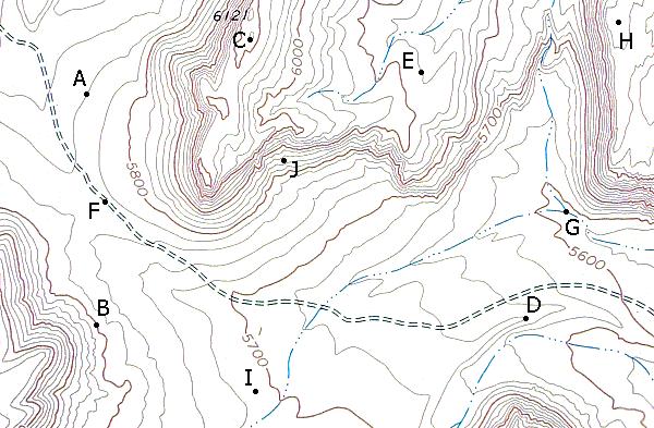
4 Intro to Contours Contour lines are the continuous brown lines found on topographic maps that give information about elevation. Each line represents a specific elevation, and all locations along that line have the exact same elevation. For example, observe the line indicted by (A) in the map above. If you were to walk along that line on the ground, your elevation would never change. Notice the words "Contour Interval 20 Feet", which are found along the bottom collar of USGS maps. This means that the elevation change between contour lines is 20 feet. The line at (D), for example, has an elevation that is 20 feet below that of (A). It follows, then, that a place on the map with many contour lines together has a large amount of elevation change-- a hillside. The area around (C) is a hillside. Likewise, places like (B) with few contour lines have little elevation change and are flat. You may have noticed that every fifth contour line is darker than the others. The darker contour lines (like (A)) are called Index Contours. If you follow an index line, you will eventually find a place where the elevation of that line is given. (E) is an example of such a place. Another way to find elevations is to use Spot Elevations, like the one shown at (F). These consist of an 'X' next to a number. The number tells the elevation at the location marked by the X. The X indicated by (F) has an elevation of 7,740 feet. There is also another spot elevation on this map. It says '7901T'. Ignore the T, and the elevation there is 7,901 feet. Using Contours to Determine Land Shape How can you tell which side of a hillside is the highest? There are several ways. For the first, look at contour lines (A) and (B) in the map above. Note that (A) is at 7500 ft. and (B) is at 7600 ft. Any line from (A) to (B), then, should be uphill. If you were to travel from east to west on line (C), for example, you would travel uphill. Since the difference between (A) and (B) is 100 feet, there would be exactly 100 vertical feet of elevation gain. A quicker way to find elevation changes is to use creeks and streams. Since water travels downhill, finding the direction that a stream travels can quickly tell you about relief along the length of the watercourse. Fortunately, it is easy to do. Look at the stream indicated by (D) above. Notice that when contour lines run into this stream, they form a 'V' shape that appears to point to the left. On all streams, the V formed by contour lines always points upstream, and therefore uphill.
 and (I)?")
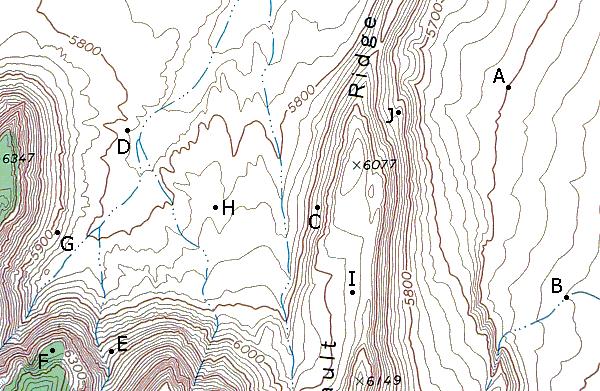
5 This tells you that the highest point along that hillside is at the left side. Also, check the V shape at point (E). Even though the stream is in a relatively flat area, the upstream-pointing V is still visible. What about the hillside between (H) and (I)? Most larger streams tend to flow at a low point between two high points-- in this case, (I) and (J). From point (H), then, you would be walking uphill if you went east or west. Also, a closed circle like the small one at (I) indicates a high point. At point (F), you can see that the contour lines form V's that point uphill. This may be a dry or intermittent stream. The land shape indicated by uphill-pointing V's, whether or not there is a stream, is a small canyon or gully. (G) is similar, except the rounded V's appear to point downhill. On the ground, this looks like a promontory that extends outward. More About Contours This map may look considerably more difficult to interpret, but don't panic. First, look at index contours (A) and (B). You can see that (A) is at 8200 feet and (B) is at Therefore, a walk from (A) to (B) would be uphill (you can examine the stream at (G) to confirm this). Now look at the line at (C). The contour interval for this map is 20 feet. This means that (C) has an elevation of 8220 feet, since it is one line uphill from (A). Line (D), then has an elevation of 8240 feet. The elevation of areas between contour lines is simple enough to approximate. Location (E) is between the 8220 and 8240 contour lines, so its elevation is somewhere between those figures. But what about the contour line surrounding (F)? If you were to walk from (E) to (F), would you go uphill or downhill? To answer that, it helps to know that every regular closed circular-shaped contour line is a high point. The contour circle at (H), for example, shows that the land inside it is higher than the surrounding land. Similiarly, (F) is a high point, and a walk from (E) to (F) would be uphill. The elevation of the contour line around (F) is actually 8240, the same as at (D). If you were to walk between (D) and (F), your elevation would drop somewhat, then increase as you crossed the 8240 contour again. Concentric circles, such as those found around (K), always have a high point at their center.
 and (J) are both at the same elevation.")

6 There is one exception to the above rule about closed contours being high points. Note the index contour at (I). There are tiny tick marks pointing to the inside of the shape. This is a depression with no outlet. The contour line is at 8200 feet, and everything inside it is less than 8200 feet. Contour lines (I) and (J) are both at the same elevation. If you were to walk from (J) to (I), you would climb slightly above 8200 feet before dropping into the depression (8199 feet). If you had some trouble with some of the tougher spots on the previous map, check this one out. It has many of the crucial non-index contours marked. In addition, all the arrows on it point from lower places to higher places. This should help you to better understand contour lines. And if you can read this topographic map, you can read just about any one.
7 Calculating Slope Angle This is a nifty trick that is especially useful for hikers who like to go cross-country and climb mountains. You can also use it to find out how steep, on average, a trail will be. Take a look at the map above. In real life, Avalanche Peak has a trail to the summit. But we'll pretend it doesn't. You want to reach the top, and you're considering two routes, (A) and (B). (A) has two separate parts that are steep, while (B) has one long, steep section. First, select a section to measure. Try to pick the steepest segment of the climb, and one that has uniform contour lines between two points. Then measure the ground distance using a ruler and scale (for paper maps) or software (for digital maps). In this example, segment (C) turns out to be 730 feet in length (on the ground). Then determine vertical rise, using the contour lines. Here, the interval is 40 feet, for a total rise of 200 feet. Now that you have Rise (elevation change) and Run (length), calculating grade is easy with a calculator. The formula is (Rise/Run)*100. In this case, it would be (200/730)*100 = 27.4% gradient. You can use this technique on places you have been to determine what the grade for a steep trail is, or for a climbable scree slope. Gradient is simply a measure of feet of rise per 100 feet of run. I prefer to get an actual measure of a route's slope in degrees from the horizontal. Unfortunately, it requires a bit of trigonometry. The formula is arctan(rise/run). You can do this using the Windows calculator by turning it to Scientific mode. First, check 'Inv' on. Divide the Rise by the Run, then select 'tan'. This is the slope's angle in degrees. It may seem surprisingly small, but keep in mind that 15 degrees is a very steep trail and 30 degrees is a steep mountain slope. Back to the example. It turns out that (C) is a 15 degree slope, (D) is 30 degrees, and (E) is 36 degrees. Both (D) and (E) would be steep, tough climbs, but (D) might be the better choice. Good luck using this method. I hope you can plan many fun trips using it.
8
9
Figure 1 Understanding Map Contours
 Figure 1 Understanding Map Contours The light brown lines overprinted on topographic maps are called contour lines. They indicate the elevation above sea level of land features and thus permit you to view
MiSP Topographic Maps Worksheet #1a SLOPE AND TOPOGRAPHIC CONTOURS
 MiSP Topographic Maps Worksheet #1a Name Date Introduction: SLOPE AND TOPOGRAPHIC CONTOURS Topographic contours are shown by lines of different widths. Each contour is a line of equal elevation; therefore,
MiSP Topographic Maps Worksheet #1a L2
 MiSP Topographic Maps Worksheet #1a L2 Name Date SLOPE AND TOPOGRAPHIC CONTOURS Introduction: Topographic contours are shown by lines of different widths. Each contour is a line of equal elevation; therefore,
A topographic map shows:,,,,
 Name: Period: Mapping the Earth Notes What is a map? Label the compass directions: What does latitude measure? What is the name of the 0 latitude line? Where is 90 north latitude? Where is 90 south latitude?
SLOPE CALCULATION. Wilderness Trekking School 1
 SLOPE CALCULATION By Joe Griffith, February 2014 Objectives Upon completion of this chapter, you will be able to: Read the rise-over-run from a topographic map. Convert the rise-over-run into a slope angle
Below is an example of a well laid-out template of a route card used by the Sionnach Team which is a good format to begin with.
 Route Card A route card is used as a navigational aid to hill walkers by setting out a step by step plan for an intended hike. It is good practice to make out a route card before every hike you or your
Road Scholar Gopher Science Olympiad Invitational January 6, Team #: Team Name: Names: Score:
 Road Scholar Gopher Science Olympiad Invitational January 6, 2018 Team #: Team Name: Names: Score: Welcome to Road Scholar! Your Science Olympiad team is planning a trip to an invitational tournament in
Topographic Maps. Practice Packet. Block: Name:
 Topographic Maps Practice Packet Name: _ Block: _ / Map Elevation Exercise Identify the elevation of each point identified on the map above. A:, D: ----- _ B: _ E: _ G: ----- B: ----- c: _ F: _ Identify
Scale Drawing of Roller Coaster
 Scale Drawing of Roller Coaster Worksheet #4 Name Directions: Below is a scale drawing of a portion of the Millennium Force, a roller coaster located in Cedar Point Amusement Park in Ohio. Answer the questions
Topo Map Explorer. Adapted from: An original Creek Connections activity. Creek Connections, Box E, Allegheny College, Meadville, Pennsylvania, 16335
 Topo Map Explorer Adapted from: An original Creek Connections activity. Creek Connections, Box E, Allegheny College, Meadville, Pennsylvania, 16335 Review of major topographic map concepts Grade Level:
CHAPTER 12: AERONAUTICAL CHARTS AND NAVIGATION
 CHAPTER 12: AERONAUTICAL CHARTS AND NAVIGATION Once you start to venture out from your home gliderport, you need to be able to figure out where you are and how to get where you want to go. Aeronautical
October 18, SWBAT identify key features on topographic maps SWBAT identify landforms on topographic maps
 October 18, 2016 Aims: SWBAT identify key features on topographic maps SWBAT identify landforms on topographic maps Agenda 1. Do Now 2. Class Notes 3. Guided Practice 4. Independent Practice 5. Practicing
GC 225 Lecture Exam #2
 GC 225 Lecture Exam #2 Direction- path along which something is moving. 3 Types; - COMPASS DIRECTIONAL NAME (32 in total) - BEARING (four 0 o - 90 o ) - AZIMUTHS (0 o - 360 o ) Compass (32 named points)
Ribbon Cliff - Ribbon Mesa text and photos by Charlie Hickenbottom
 Ribbon Cliff - Ribbon Mesa text and photos by Charlie Hickenbottom Looking for something a little different than Sage Hills or Saddlerock? Perhaps something a little wilder, a little less traveled? Look
Trail Phasing Plan. Note: Trails in the Clear Creek Canyon area (Segments will be finalized in the future to minimize wildlife impacts
 Note: Trails in the Clear Creek Canyon area (Segments 2 5 and a future JCOS connection) will be finalized in the future to minimize wildlife impacts Trail Phasing Plan P Parking 3 Easy Trail Intermediate
2012 Oregon State Science Olympiad. B-Division Road Scholar Event National Wildlife Refuge Site Selection. Student Participants:
 2012 Oregon State Science Olympiad B-Division Road Scholar Event National Wildlife Refuge Site Selection Student Participants: School/Team: To answer the questions you will need a pencil, ruler, protractor,
Trail Assessment Report
 Trail Assessment Report Trail Options for the Bear Creek Canyon located in Pikes Peak Ranger District, Pike National Forest and on Colorado Springs Utility Lands Due to the presence of a unique species
Topographic Maps. Background Sheet
 Topographic Maps History: Background heet The Articles of Confederation (1777) was ratified when western lands were yielded to the Federal Government. This yielding of land gave the Federal Government
5 MAP SPECIFICATION FOR SKI-ORIENTEERING
 5 MAP SPECIFICATION FOR SKI-ORIENTEERING 5.1 General Maps for ski orienteering are based on the specifications for foot-orienteering maps. However in order to meet the specific requirements put on the
Rogue Gorge (Mt. Stella) Roadless Area-- T30S R3E (primarily in portions of Sections 23, 26, 33, 34 & 35)
 Roadless Area-- T30S R3E (primarily in portions of Sections 23, 26, 33, 34 & 35)") Rogue Gorge (Mt. Stella) Roadless Area-- T30S R3E (primarily in portions of Sections 23, 26, 33, 34 & 35) Rogue River-Siskiyou National Forest--High Cascades Ranger District Upper, higher elevation trail
Rogue Gorge (Mt. Stella) Roadless Area-- T30S R3E (primarily in portions of Sections 23, 26, 33, 34 & 35) Rogue River-Siskiyou National Forest--High Cascades Ranger District Upper, higher elevation trail
Camp Jack Wright PERMANENT ORIENTEERING COURSE (2004)
") Camp Jack Wright PERMANENT ORIENTEERING COURSE (2004) WHAT IS ORIENTEERING? The skill which enables a person to navigate with a map. In the competitive sport, the winner is the person who finishes in the
Camp Jack Wright PERMANENT ORIENTEERING COURSE (2004) WHAT IS ORIENTEERING? The skill which enables a person to navigate with a map. In the competitive sport, the winner is the person who finishes in the
c. 1 inch = 0.6 miles e. 1:100,000 f. 1:250,000 f. 1 inch = 4.0 miles
 High School Advance Geology Map Test 2014 Name Use the information on each map to provide the best answer to the questions. Fill in the bubble of the best answer on your answer sheet. Answer questions
Route #1) Mt. of the Holy Cross - North Ridge
 Mt. of the Holy Cross - North Ridge") Climbing 14ers can be very dangerous, please read the Mountaineering Safety Page and make sure you have a map+compass and can use them effectively, without the help of electronic devices. Route #1) Mt.
Climbing 14ers can be very dangerous, please read the Mountaineering Safety Page and make sure you have a map+compass and can use them effectively, without the help of electronic devices. Route #1) Mt.
INTERPRETING TOPOGRAPHIC MAPS (MODIFIED FOR ADEED)
") INTERPRETING TOPOGRAPHIC MAPS (MODIFIED FOR ADEED) Science Concept: Topographic maps give information about the forces that shape the features of Earth. Objectives: The student will: identify land features
INTERPRETING TOPOGRAPHIC MAPS (MODIFIED FOR ADEED) Science Concept: Topographic maps give information about the forces that shape the features of Earth. Objectives: The student will: identify land features
TUPPER DESIGNATED ACCESS ROUTE
 TUPPER DESIGNATED ACCESS ROUTE 1 FOR ACCESS/EGRESS TO CONNAUGHT, LOOKOUT, STONE ARCH, PORTAL PATHS AND TUPPER TRAVERSE EGRESS Length: 2.6km Vertical Gain: +162m / -83m (Values are for access. For egress,
CIEC 9 PEAKS AWARD SUPPLEMENT POSSIBLE ROUTES FOR THE 9 PEAKS AWARD TRIP
 CIEC 9 PEAKS AWARD SUPPLEMENT POSSIBLE ROUTES FOR THE 9 PEAKS AWARD TRIP As you plan your trip, be aware of 3 regulations in this wilderness: 1. Camp only in designated campsites. 2. No campfires allowed.
Answers to Your Turn. Chapter 2. Maps and mapping
 Geog. 1 Answers to Your Turn Chapter 2. Maps and mapping Chapter 2.1 Mapping connections 1. A = Isle of Man; B = Northumberland; C = Cornwall; D = Surrey; E = Shrewsbury; F = Nigeria; G = Japan; H = China;
Guide Book Excerpts. Wham Ridge 2006
 Guide Book Excerpts Wham Ridge 2006 Approach: Molus Lake / Elk Park / Vestal Creek Roach and Roach Description Take the Durango & Silverton Narrow Gauge train from either Durango or Silverton and get off
Looking back across Emerald Lake at Wapta Mountain (on the left) and Mount Burgess (on the right):
 and Mount Burgess (on the right):") YOHO LAKE FROM EMERALD LAKE, YOHO NATIONAL PARK, BRITISH COLUMBIA, CANADA We decided to hike to Yoho Lake from Emerald Lake even though the distance is longer than the trail from Takakkaw Falls (about
YOHO LAKE FROM EMERALD LAKE, YOHO NATIONAL PARK, BRITISH COLUMBIA, CANADA We decided to hike to Yoho Lake from Emerald Lake even though the distance is longer than the trail from Takakkaw Falls (about
Note that the steepest 8 direction pour point model slope in direction 64 is: 10.0
 GIS in Water Resources Exercise #3 Solution Part 1. 1.1 Hand Calculations (i) The standard ESRI surface slope function Grid size 10 m Diagonal distance= 14.142 m 47.5 48 47.7 50.6 48.3 dz/dx= -0.125 45.1
Self-Guided Walk Langdale Pikes. Start & Finish: NT car park (free to members) at Sticklebarn - on the right just beyond the New Dungeon Ghyll hotel.
 at Sticklebarn - on the right just beyond the New Dungeon Ghyll hotel.") Self-Guided Walk Langdale Pikes Key Information These mountains form a collection of spires and cliffs on the north side of Langdale. This walk visits four of the main tops Pavey Ark, Harrison Stickle,
Self-Guided Walk Langdale Pikes Key Information These mountains form a collection of spires and cliffs on the north side of Langdale. This walk visits four of the main tops Pavey Ark, Harrison Stickle,
Learning. to Hunt. Hosting a huntingbased outdoor skills event in your community
 Learning to Hunt Hosting a huntingbased outdoor skills event in your community Mary Kay Salwey, Ph.D. Wisconsin Department of Natural Resources 2004 Project Director Learning to Hunt Credits Mary Kay Salwey,
HIKING IN THE CANADIAN ROCKIES
 HIKING IN THE CANADIAN ROCKIES Distance Time Elevation y MORAINE LAKE TRAILS THE ROCKPILE 0.8 km (0.5 mi) 20 min 30 m (98 ft) Located adjacent to the Lodge, the short interpretive trail up the Rock Pile
Beautiful Walks from the Blue Ball Inn
 Walk No. 2 WINSTONS WALK Countisbury, Wind Hill, Watersmeet, Ash Bridge and Winston s path. 5 Miles approx. Walking time- Two and a half hours approx. (Not including Breaks) OS 1:25,000 Sheet 64/74 Lynton
Datum Issues in the Red River of the North Basin ----
 Datum Issues in the Red River of the North Basin ---- Scoping Document May 1999 Russell E. Harkness, Hydrologist United States Geological Survey Water Resources Division 2 EXECUTIVE SUMMARY Two datum issues
LAB 5-2 ENERGY CONSERVATION
 NAME: PERIOD: LAB 5-2 ENERGY CONSERVATION QUESTION: What is energy and how does it behave? In this investigation, you will: 1. Discover the relationship between speed and height on a roller coaster. 2.
The Atlas of Hillforts of Britain and Ireland. Hillfort survey notes for guidance
 The Atlas of Hillforts of Britain and Ireland Hillfort survey notes for guidance The collection of surveys for the Atlas is now finished but you can use this form and the accompanying Notes for Guidance
A Rope, a Goat, a Shed, and a Silo
 A Rope, a Goat, a Shed, and a Silo by: Joshua Wood Problem: Grazing area. Farmer Jones had a goat on a tether. He tied the end of the tether not attached to the goat to a stake in a field. Over what area
IMPORTANT DEFINITIONS DEFINITIONS FROM TOPO MAPS
 IMPORTANT DEFINITIONS DEFINITIONS FROM TOPO MAPS 1. REPRESENTATIVE FRACTION (RF): It is the ratio between the distances on the map to its corresponding distance on actual ground. The RF on this map is
NAVIGATION: CHARTS, PUBLICATIONS, FLIGHT COMPUTERS (chapters 7 & 8)
") NAVIGATION: CHARTS, PUBLICATIONS, FLIGHT COMPUTERS (chapters 7 & 8) LONGITUDE AND LATITUDE 1. The location of an airport can be determined by the intersection of lines of latitude and longitude. a. Lines
NAVIGATION: CHARTS, PUBLICATIONS, FLIGHT COMPUTERS (chapters 7 & 8) LONGITUDE AND LATITUDE 1. The location of an airport can be determined by the intersection of lines of latitude and longitude. a. Lines
APPENDIX D: SUSTAINABLE TRAIL DESIGN. APPENDICES Town of Chili Parks and Recreation Master Plan Update
 APPENDIX D: SUSTAINABLE TRAIL DESIGN APPENDICES Town of Chili Parks and Recreation Master Plan Update Sustainable Trail Construction Sustainable trails are defined by the US Forest Service as trails having
Marilla Reservoir to Chestnut Ridge via Marilla Trails and Bullis Hollow Trail east to west
 USGS topographic maps useful to this hike are the Bradford and Stickney 7.5 minute sectionals. These notes are designed to assist in identifying distance and location using geophysical and man-made characteristics
Unit 7 Lesson 4 : Topographic Maps
 Unit 7 Lesson 4 : Topographic Maps Edit File Screen 1 - W elcom e PRI OR KNOWLEDGE W hy do people use m aps? People use m aps to see where they are and to find out how to get where they want to go. For
Kirigalpoththa Nature Trail Horton Plains National Park
 Kirigalpoththa Nature Trail Horton Plains National Park Trail Difficulty: Easy Moderate Strenuous Tough Trail Head: Horton Plains Visitor Centre Nearest Town: Pattipola Nearest City: Nanu-Oya Access to
MP : Headwaters of the Fraser River
 MP 236 237: Headwaters of the Fraser River The mile between these two mileage posts is often just referred to as the bottom switchback or the curve at the bottom of Berthoud Pass. For many locals this
DD FORM 3009, FEB 2016 REPLACES DA FORM 1247, WHICH IS OBSOLETE. Page 1 of 6 Pages Adobe Professional X
 ROUTE CLASSIFICATION For use of this form, see ATP 3-34.81/MCWP 3-17.4; the proponent agency is TRADOC. SECTION I 1. SERIAL NUMBER 2. TO 3. FOR INFORMATION 4. DATE/TIME GROUP 5. NUMBER OF SHEETS OR ENCLOSURES
Orienteering. The fundamental outdoors skill!
 The fundamental outdoors skill! Orienteering Nothing will make you feel more confident in the out of doors like knowing how to find your way in the woods. Orienteering Prepared by: Jeffrey Lybarger Assistant
A Basic Manual on Knife Throwing
 A Basic Manual on Knife Throwing By J. B. Wood Illustrated by Roy Pelz The author of this manual, Mr. J. B. "The Old Man of the Hills" Wood (Kentucky) is a well known writer on firearms and the outdoors.
Piestewa Peak/Dreamy Draw Trail Guide
 Piestewa Peak/Dreamy Draw Trail Guide Trail #1A - Perl Charles Memorial Trail Length: 4.8 miles Elevation: 2,200 ft. - 1,340 ft. Difficulty: Moderate to difficult The Perl Charles trailhead is located
HYDROLOGY OF GLACIAL LAKES, FORT SISSETON AREA
 PROC. S.D. ACAD. SCI., VOL. 77 (1998) 59 HYDROLOGY OF GLACIAL LAKES, FORT SISSETON AREA Perry H. Rahn Department of Geology & Geological Engineering South Dakota School of Mines and Technology Rapid City,
Time-Space Analysis Airport Runway Capacity. Dr. Antonio A. Trani. Fall 2017
 Time-Space Analysis Airport Runway Capacity Dr. Antonio A. Trani CEE 3604 Introduction to Transportation Engineering Fall 2017 Virginia Tech (A.A. Trani) Why Time Space Diagrams? To estimate the following:
Route Combo) Mt. Bierstadt - Bierstadt, Sawtooth, Evans
 Mt. Bierstadt - Bierstadt, Sawtooth, Evans") Climbing 14ers can be very dangerous, please read the Mountaineering Safety Page and make sure you have a map+compass and can use them effectively, without the help of electronic devices. Route Combo)
Climbing 14ers can be very dangerous, please read the Mountaineering Safety Page and make sure you have a map+compass and can use them effectively, without the help of electronic devices. Route Combo)
4.1 Landforms. Note: dimensions are specified in mm at the scale of 1: All drawings are at 1:7 500 for clarity only.
 4.1 Landforms Note: dimensions are specified in mm at the scale of 1:15 000. All drawings are at 1:7 500 for clarity only. OM = Outside measure IM = Inside measure CC = Centre to centre 0.2 0.4 OM 0.4
Baggy Point, Croyde, North Devon
 Baggy Point, Croyde, North Devon A walk using the South West Coast Path that is likely to be suitable for people with impaired mobility or with a pushchair, wheelchair, or mobility scooter. The Coast Path
Pontfadog. Walk A. Walk A
 Walk A A Bird s eye view of the village 2km. (1 1 /2 miles); height gain 45m. (150ft) about 45 minutes. Six minutes walk along the main road towards Glyn Ceiriog reach a signpost to Llwynmawr. Take the
Henderson Mountain Avalanche Accident Two riders caught, one partially buried, one fully buried
 Henderson Mountain Avalanche Accident Two riders caught, one partially buried, one fully buried Custer-Gallatin National Forest 28 November 2014 Synopsis A group of 6 or 7 snowmobilers (part of a larger
Advisory Circular AC61-3 Revision 11 SUPERSEDED Define and identify, on a diagram of the earth, and explain the meaning of the following:
 Subject No 6 Air Navigation and Flight Planning Each subject has been given a subject number and each topic within that subject a topic number. These reference numbers will be used on knowledge deficiency
Victoria Falls and Grose Valley to Blackheath Station
 This walk explores a fantastic section of the Grose Valley. Starting above Victoria Falls, the walk explores the cascades before dropping into the valley for the first nights rest at Burra Korain campsite.
12: MELTWATER LANDFORM IDENTIFICATION
 Glacial Geology 12. Meltwater Landform Identification 12: MELTWATER LANDFORM IDENTIFICATION 60 Points Objective: learn how to identify meltwater landforms and their characteristics in photos and on topographic
Leaden Boot Challenge ROUTE INSTRUCTIONS
 Leaden Boot Challenge ROUTE INSTRUCTIONS Section 1 Alstonefield to Ilam From the village hall car park turn R then L and pass through the village keeping to the R to enter Church Street. Pass the Church
Route #2) Mt. Massive - Southwest Slopes
 Mt. Massive - Southwest Slopes") Route #2) Mt. Massive - Southwest Slopes Difficulty: Class 2 Ski: Advanced, D6 / R2 / III Exposure: Summit Elevation: Trailhead Elevation: Elevation Gain: Round-trip Length: Trailhead: County Sheriff:
Route #2) Mt. Massive - Southwest Slopes Difficulty: Class 2 Ski: Advanced, D6 / R2 / III Exposure: Summit Elevation: Trailhead Elevation: Elevation Gain: Round-trip Length: Trailhead: County Sheriff:
Skiing and Snowshoes on Un-groomed Fernan Saddle Terrain
 Skiing and Snowshoes on Un-groomed Fernan Saddle Terrain Three ski or snowshoe routes are available from the Fernan Saddle Parking Lot which either do not cover routes ordinarily groomed for snow machine
SYNOPSIS WEATHER AND SNOWPACK
 Peak 6996 Avalanche Fatality Incident Report Glacier National Park, MT Date of Avalanche: 31 March 2010 Date of Investigation: 2 April 2010 Investigation Team: Erich Peitzsch (USGS), Ted Steiner (Chugach
ZIP LINE CHALLENGE. DESIGN CHALLENGE Build a device that can transport a ping-pong ball from the top of a zip line to the bottom in 4 seconds or less.
 Grades 3 5, 6 8 20 60 minutes ZIP LINE CHALLENGE DESIGN CHALLENGE Build a device that can transport a ping-pong ball from the top of a zip line to the bottom in 4 seconds or less. SUPPLIES AND EQUIPMENT
Little Grand Canyon near Pomona, Illinois
 Little Grand Canyon near Pomona, Illinois Below: View of the trail and the terrain created using the Map My Hike app Below: Summary of the hike created using the Map My Hike app Presented by: Jennifer
LAKE NEEDWOOD ORIENTEERING MEET QUANTICO ORIENTEERING CLUB SEPTEMBER 18, 2011
 NATIONAL ORIENTEERING DAY LAKE NEEDWOOD ORIENTEERING MEET QUANTICO ORIENTEERING CLUB SEPTEMBER 18, 2011 COMBINED EVENT NOTES, including: National Orienteering Day Course Designer s Notes Super String-O
Wicklow Mountains Path Survey
 Wicklow Mountains Path Survey Ballinacor Croaghanmoira Fananierin Start to Finish: T 11723 86602 to T 11175 89057 Altitude (lowest highest): 385m 664m Weather: Hot Access: Coolgarrow forest entrance Surveyed
The Niagara SkyWheel Teacher Resource Guide Grades 9-12
 The Niagara SkyWheel Teacher Resource Guide Grades 9-12 Welcome to The Niagara SkyWheel! Arrival and Entry Please allow ample time for parking and obtaining tickets. Safety To have the best adventure possible,
Tiger Mountain State Forest:
 98 60 hikes within 60 miles: SEATTLE 20 Tiger Mountain State Forest: West Tiger Mountain Three Loop i KEY AT-A-GLANCE INFORMATION Length: 5.1 miles round-trip Configuration: Loop Difficulty: Moderate difficult
Victoria Falls Lookout to Blue Gum Forest
 Victoria Falls Lookout to Blue Gum Forest 8 hrs Experienced only 13.8 km One way 5 112m This long day-walk follows a remote track down from Victoria Falls lookout, passing the waterfall, and into the Grose
LAS VARAS RANCH CA COASTAL TRAIL PROPOSED ALIGNMENT
 LAS VARAS RANCH CA COASTAL TRAIL PROPOSED ALIGNMENT Santa Barbara Trails Council * Prepared by Ray Ford February 1,2012 The following notes accompany the Santa Barbara Trails Council map for the Las Varas
SIX FLAGS GREAT ADVENTURE PHYSICS DAY REVIEW & SAMPLES
 DIRECTIONS: SIX FLAGS GREAT ADVENTURE PHYSICS DAY REVIEW & SAMPLES For your assignment you will answer Multiple Choice questions and Open Ended Questions. All students must do the Great American Scream
Lidar Imagery Reveals Maine's Land Surface in Unprecedented Detail
 Maine Geologic Facts and Localities December, 2011 Lidar Imagery Reveals Maine's Land Surface in Unprecedented Detail Text by Woodrow Thompson, Department of Agriculture, Conservation & Forestry 1 Introduction
Aim: What is the Height and Co-Height functions of a Ferris Wheel?
 Do Now: Suppose a Ferris wheel has a radius of 50 feet. We will measure the height of a passenger car that starts in the 3 o clock position with respect to the horizontal line through the center of the
CWMGIEDD FROM ABERCRAVE
 Abercrave to Cwmgiedd Walk Page 1 Starting from The Abercrave Inn. Grid Ref: SN 824128 From the Abercrave Inn, an 11.3km (7 miles) walk to the foothills of the Cribarth Mountain, then through forest to
Leaden Boot Challenge 2016 ROUTE INSTRUCTIONS
 Leaden Boot Challenge 2016 ROUTE INSTRUCTIONS Section 1 Alstonefield to Ilam (CP2) From the village hall car park turn R then L and pass through the village keeping to the R to enter Church Street. Pass
Kennesaw Mountain Trail Club. Trail Skills Workshop ~ Dips and Drains. Presented by: Jay M Dement
 Kennesaw Mountain Trail Club Trail Skills Workshop ~ Dips and Drains Presented by: Jay M Dement KEY CONCEPTS: Control Erosion and Users Where Do Trails Come From, and How Do They Work: Concept of trail
Oregon Section C - Page 1 WGS84 Zone 10T m
 00 N. 99 N. 98 N. 97 N. 96 N. 557000m Oregon Section C - 74.4 miles Start - Hwy 140, mile 1773.4 (near Fish Lake) End - Hwy 138, mile 1847.8 (near Cascade crest) Elevation Gain +8,111' Elevation Loss -7,145'
1. Waterfall Gully Mt Lofty. 5 Of the Best Hikes in Adelaide
 Adelaide is a beautiful city, and one of the most incredible things about Adelaide is the quality of bushwalking available on the suburban fringe. It is surrounded by the Mt Lofty Ranges, and much of the
San Luis Obispo. Bishop Peak Felsman Loop Eagle Rock Maino Open Space Poly Canyon Poly P Other Areas
 San Luis Obispo Bishop Peak Felsman Loop Eagle Rock Maino Open Space Poly Canyon Poly P Other Areas 1 JCT. ELEV. 72 400 00 0 FELSMAN LOOP GATE LOOP RIDGE 600 FENCE JCT. ELEV. 860 1000 1200 BISHOP PEAK
Preliminary Site Evaluation
 Preliminary Site Evaluation 100 Acre Site, US 72 Piperton, Tennessee Power Distributor: Chickasaw Electric Cooperative August 2010 SITE DATA SHEET PIPERTON US 72 SITE (100 ACRES): LOCATION & GENERAL DESCRIPTION
Location: Height: Access: Distance: Elevation: Season: Difficulty: Lat/Long: Directions:
 Upper Eagle Falls Upper Eagle Falls (~20 ft.) is a short hike up from the roadside at the Eagle Falls picnic area. It is very difficult to get a parking spot here during the day, so it is recommended to
Control Description Sheet 1
 Control Description Sheet 1 Headings I0A Example M20 M21 M35 1 8.8km 250m Event Title Classes (optional) Course Code; Course length, Height climb Start location as if it was a control. First Control Description
Shenandoah National Park (National Geographic Trails Illustrated Map) PDF
 PDF") Shenandoah National Park (National Geographic Trails Illustrated Map) PDF â Waterproof â Tear-Resistant â Topographic MapExpertly researched and created in partnership with local land management agencies,
Shenandoah National Park (National Geographic Trails Illustrated Map) PDF â Waterproof â Tear-Resistant â Topographic MapExpertly researched and created in partnership with local land management agencies,
Grizzly Peak A - East Ridge July 15, 2012
 Grizzly Peak A - East Ridge July 15, 2012 Difficulty: Difficult Class 2/Class 3 Upper Elevation: 13,995 feet Trailhead Elevation: 11,360 feet Elevation Gain: 3,000 feet Round-trip Length: 6.0 miles Trailhead:
2015 Cordillera Central Mountains of Peru, Sullcon and Paca climbing Expedition
 Introduction The Cordillera Central (also called the Huarochiri or Pariacacca Mountains) is the closest Andean Mountain Range to Lima the Capital of Peru (see Map 1). It is located approximately 80 to
Rediscovering the Butterfield Trail Through Satellite Imagery Interpretation: Fort Chadbourne to the Pecos River
 Rediscovering the Butterfield Trail Through Satellite Imagery Interpretation: Fort Chadbourne to the Pecos River Tom Ashmore Abstract Although the Butterfield Trail s route through West Texas is generally
Math in Motion Idlewild & SoakZone Copyright
 STUDENT PACKET MATH IN MOTION Your visit to Idlewild & SoakZone is an opportunity to not only have fun, but learn about math and the use of technology throughout the park. Use our Outdoor Classroom to
DATE: 23 March, 2011 TO: Communities FROM: BlazeSports America. RE: Accessible Trails Checklist 1
 M E M O R A N D U M DATE: 23 March, 2011 TO: Communities FROM: BlazeSports America RE: Accessible Trails Checklist 1 The purpose of the Accessible Trails Checklist (below) is to help the community review
MP : Blue Hill and the Disney Avalanche Path
 MP 252-253: Blue Hill and the Disney Avalanche Path This section of the Auto Tour includes a portion of the wagon road, one of Colorado s most famous avalanches and the remains of an old dam. Route Mile
Trail Beginning Elevation: 7553 ft The Poison Creek Trailhead is located at the end of National Forest Road 646E (NF-646E).
.") West Mountain Trails Poison Creek Trail #134 Length: 2.9 miles (4.7 km) Difficulty Horseback: A good trail for the first time west mountain rider, some steep sections Hiking: Most Difficult USGS Maps:
West Mountain Trails Poison Creek Trail #134 Length: 2.9 miles (4.7 km) Difficulty Horseback: A good trail for the first time west mountain rider, some steep sections Hiking: Most Difficult USGS Maps:
MAPPING OF ROCK FEATURES 2.9
 MAPPING OF ROCK FEATURES 2.9 Introduction 1 The mapping of rock in recent years has been one of the strengths of orienteering in Australia. This has been largely because our granite terrain has presented
HARDMOORS 55 RACE ROUTE 2018 HELMSLEY - GUISBOROUGH
 HARDMOORS 55 RACE ROUTE 2018 HELMSLEY - GUISBOROUGH HELMSLEY - CHECKPOINT 1 (WHITE HORSE) 1. Leave RACE START, continue ahead on road (Baxtons Sprunt) At crossroads turn right down Canons Garth eventualy
Telluride-to-Moab Alternative Singletrack Options
 Telluride-to-Moab Alternative Singletrack Options Day 1 Day 1 Alternate 1: Galloping Goose to Deep Creek. 18.4 miles, ascent 3,530ft, descent 1,388ft. This is fun, flowey, moderate to intermediate singletrack
Dixon Trail Construction - From the Top of the Mountain 2016 Interim Report Friends of Cheyenne Mountain State Park September 2 nd, 2016
 - Dixon Trail Construction - From the Top of the Mountain 2016 Interim Report Friends of Cheyenne Mountain State Park September 2 nd, 2016 Prepared by: Andy Riter, Program Coordinator, and Joe Lavorini,
Mt. Elbert East Ridge
 Mt. Elbert East Ridge Difficulty: Class 1 Exposure: None Summit Elev.: 14,440 feet Trailhead Elev.: 10,400 feet Elevation Gain: 4,100 feet Roundtrip Length: 8.5 miles Trailhead: South Elbert (near Twin
Beautiful Walks from the Blue Ball Inn
 Walk No. 5 RIVER VALLEYS AND MOOR Countisbury, Watersmeet, Hillsford Bridge, Cheriton, Shilstone Hill, Rockford and Chiselcombe. 8.5 MILES APPROX. Walking time four and a half hours approx. OS 1;25,000
YOSEMITE ON HORSEBACK: THREE RIDES ALONG TIOGA ROAD Cindy Casey White Wolf Area, May Lake Loop, Ragged Peak Loop
 YOSEMITE ON HORSEBACK: THREE RIDES ALONG TIOGA ROAD Cindy Casey White Wolf Area, May Lake Loop, Ragged Peak Loop The high country along Tioga Road presents us with some of the most dramatic scenery in
DATE OF AERIAL PHOTOGRAPHY:
 DESCRIPTION RUNWAY SAFETY AREA RUNWAY PROTECTION ZONE TAXIWAY OBJECT FREE AREA DATE OF AERIAL PHOTOGRAPHY: 6-17-01 RUNWAY SAFETY AREA FOR PORTION OF RUNWAY 16L-34R SOUTH OF RUNWAY BRIDGE HAS A FAA WAIVER
MP : the top of the bottom switchback
 MP 237 238: the top of the bottom switchback For reference this section of U S Highway 40 has been called the top of the bottom switchback on the Grand County side of the Pass. It is here that the proposed