ATVANS Trail Assessment for Five Bridge Lakes Wilderness Area Report and Recommendation. December 28, Prepared by.
|
|
|
- Reginald Cole
- 5 years ago
- Views:
Transcription
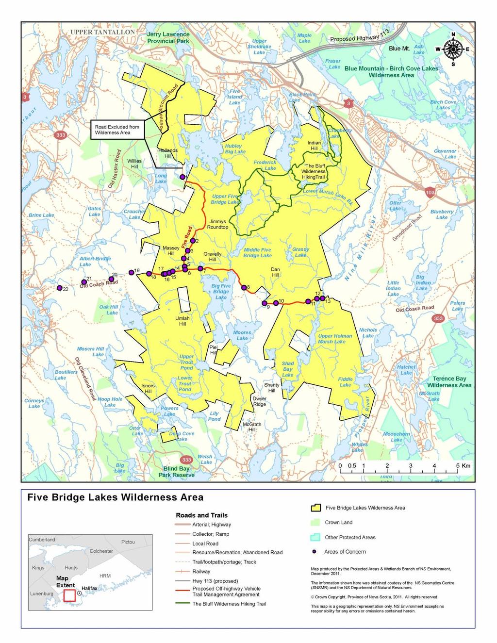
1 ATVANS Trail Assessment for Five Bridge Lakes Wilderness Area Report and Recommendation December 28, 2011 Prepared by Peter Bush Background This report documents the results and recommendations of an all-terrain vehicle (ATV) trial assessment at Five Bridge Lakes Wilderness Area, undertaken on November 25 and December 7. Jointly by: NSE, NSDNR, ATVANS, Safety Minded ATC association (see Appendix A for participants). Vehicle use in provincially-designed wilderness areas is generally prohibited; however, under S.23(4) of the Wilderness Area Protection Act, an essential trail link with a more extensive regional trail network can be authorized for new wilderness areas, such as Five Bridge Lakes Wilderness Area, provided the route will eventually be relocated outside or near the boundary of the wilderness area, and that the continued use or operation of vehicles within the wilderness area will have minimal environmental impact on the wilderness area. Authorization is provided through a trail management agreement with a group or organization, such as ATVANS. The objective of this trail assessment was to identify the most suitable ATV trail through Wilderness Area, which will link to the regional ATV trail network, and to describe which upgrades or improvements, if any, may be needed to minimize environmental impacts of ATV use on this trial.
2 Trial Assessment Findings The recommended trail route, within Five Bridge Lakes Wilderness Area, shown on the attached map was based on previous public consultation and field assessment. All of these trails, uses existing road and routes, and is approximately 13 km in length. The Fire Road route is located on the western portion of the Wilderness Area and connects to a regional trial network in the north and to The Coach Road. The Coach Road route connects communities of Greenwood (the east side of the Wilderness Area) with Seabright and Glen Margaret (on the west side of the Wilderness Area). The routes are generally in good shape with a number of exceptions. The first priority will focus on water management and hazard removal: Installing bridges or culvert structures on stream crossing, improve drainage to prevent water from running down the slopes eroding the trial, wetlands crossing, and removal submerged rocks from depressions. The second priority is infrastructure remediation: replacing heaved culverts and washouts, replacing large wooden culverts with bridges, draining and repairing the deep waterholes (Fill), bring bridges up to DNR OHV trail bridge standards. The third priority is User Management: blocking access to unauthorized side trails, reducing width of trail to 2-3 m, construction of connector trail, access control installation of bollards gates and appropriate parking at access points. The attached map identifies the routes and highlights some of the key areas of concern of the Fire Road and western portion of Old Coach Road, within the Wilderness Areas, as well as connecting routes. Other areas of concern may exist on the trail and will still be required to be repair. *Note no fieldwork has completed on the Old Coach Road East of the Nine Mile River.
3 ID Comment Sections 1-6/ These sections to be worked on in /13[phase 1]intention is to finish by end of 2012[weather/funding permitting] 1 Decking on existing Bridge 1a 24 culvert x 20 foot 1b 24 culvert x 12 foot 2 8' bridge[supervised by corey robar[atvans] 3 Water on road over of Culvert, ditching, culvert-24 x 12 foot 4 Gravel pit play-area, needs signage and restricted access, and rehabilitation 5 Water running down road, starts at T junction Dicthing/culvert. 6 Water problem at T Junction west on Coach Rd ditching and surface water diversion to downhill slope. Sections 7-13[in red] This section will be worked on in 2013[phase 2]Some road work may be done this year if first phase is completed and weather permits] 7 Long term Bridge Replacement, existing wood culvert currently working 8 Big Mud hole, build up road with fill 9 8' Bridge 10 Wetland raise platform work needed 11 Fill need 12 8' Bridge ' Bridge culvert culvert 16 Fill and ditching,24 culvert 17 8 Bridge[supervised by Corey Robar[atvans] 18 Fill needed, few loads, remove big rocks Sections 19-22[in green] This section is TIR [DOT]jurisdiction,LOA applied for by SMATVA,needed before we can apply to address work required.[pending] 19 Small stream, culvert 20 Underground streams (3) culverts or cross drains 21 8 foot Bridge 22 Broken Culvert, new Culvert needed
4 Appendix A November 25 Trail Inspection Peter Bush, NSE Mike Marriot, SMATVA Club President Sandy Anderson, NSDNR Corey Robar, ATVANS Trails Coordinator December 7, 2011 Trail Inspection Peter Bush, NSE Mike Marriot, SMATVA Club President
5
Off Highway Vehicle Infrastructure Fund Fiscal year Summary Report
 Off Highway Vehicle Infrastructure Fund Fiscal year 2014 Summary Report June 2015 Introduction The Off-highway Vehicle Infrastructure Fund (the Fund) was established as a result of recommendations of the
Off-Highway Vehicle Infrastructure Fund
 Summary Report Off-Highway Vehicle Infrastructure Fund Fiscal year 2015/2016 September 2016 Summary Report Off-Highway Vehicle Infrastructure Fund Fiscal year 2015/2016 September 2016 Crown copyright,
1. PROJECT BACKGROUND. June 25, Alberta Transportation Central Region #401, Street Red Deer, Alberta T4N 6K8
 Alberta Transportation Central Region #401, 4902 51 Street Red Deer, Alberta T4N 6K8 June 25, 2001 Mr. Melvin Mayfield, P.Eng. Construction Services Coordinator Dear Mr. Mayfield: Central Region Landslide
Prior to contacting the Whitecourt Trailblazers Snowmobile Club, applicants must:
 WHITECOURT TRAILBLAZERS Box 607 Whitecourt, AB T7S 1N7 www.whitecourttrailblazers.ca CNT AMENDMENT Restriction Code 710: See Comments Comments All applicants are required to contact: Whitecourt Trailblazers
5.0 OUTDOOR RECREATION OPPORTUNITIES AND MANAGEMENT
 5.0 OUTDOOR RECREATION OPPORTUNITIES AND MANAGEMENT 5.1 Introduction This section describes the range of recreational activities that currently take place in Marble Range and Edge Hills Parks, as well
Emily to Blind Lake Trail PROPOSED TRAIL DEVELOPMENT APPLICATION SUMMARY
 Emily to Blind Lake Trail PROPOSED TRAIL DEVELOPMENT APPLICATION SUMMARY Township 137 Range 26 (Fairfield Township) sections 2 & 3 Township 138 Range 26 (City of Emily) sections 27, 34, 35, & 36 Township
Rule Governing the Designation and Establishment of All-Terrain Vehicle Use Trails on State Land
 Rule Governing the Designation and Establishment of All-Terrain Vehicle Use Trails on State Land 1.0 Authority 1.1 This rule is promulgated pursuant to 23 V.S.A. 3506. Section 3506 (b)(4) states that an
Stein Valley Nlaka pamux Heritage Park
 Stein Valley Nlaka pamux Heritage Park - Trail Information Update and Winter Advisory November 2017 March 2018 Welcome to Stein Valley Nlaka pamux Heritage Park! **This trail update is to inform park users
DRAFT. Dorabelle Campground Rehabilitation
 DRAFT Dorabelle Campground Rehabilitation September 2012 1.1 REGIONAL SETTING AND PROJECT LOCATION The Dorabelle Campground is located on the western shore of Shaver Lake in Fresno County, California (Section
BACKCOUNTRY TRAIL FLOOD REHABILITATION PROGRAM
 BACKCOUNTRY TRAIL FLOOD REHABILITATION PROGRAM Backcountry Trail Flood Rehabilitation A June 2013 Flood Recovery Program Summary In June 2013, parts of Southern Alberta were devastated from significant
Procedure for the Use of Power-Driven Mobility Devices on Mass Audubon Sanctuaries 1 September 17, 2012
 Procedure for the Use of Power-Driven Mobility Devices on Mass Audubon Sanctuaries 1 September 17, 2012 Background As part of Mass Audubon s mission to preserve the nature of Massachusetts for people and
Bradley Brook Relocation Project. Scoping Notice. Saco Ranger District. United States Department of Agriculture Forest Service
 Bradley Brook Relocation Project United States Department of Agriculture Forest Service Scoping Notice White Mountain National Forest February 2011 For Information Contact: Jenny Burnett White Mountain
Bear Creek Habitat Improvement Project
 06/10/10 Bear Creek Habitat Improvement Project El Paso County, Colorado Pike National Forest and Colorado Springs Utilities Owned Land Report prepared by: Eric Billmeyer Executive Director Rocky Mountain
GOLDEN EARS PROVINCIAL PARK
 GOLDEN EARS PROVINCIAL PARK Trail Information as of October 10 th 2015 Do not underestimate the mountainous wilderness of Golden Ears Provincial Park. The combination of rugged terrain and rapidly changing
Walking Track Classification System Parks and Wildlife Service
 Appendix A Walking Track Classification Specifications Walking Track Classification System Parks and Wildlife Service This Walking Track Classification System is the outcome of a review of the track classifications
Non-motorized Trail Plan & Proposal. August 8, 2014
 Town of Star Valley Ranch, Wyoming and the Star Valley Ranch Association in partnership with the USDA Forest Service, Bridger-Teton National Forest, Greys River Ranger District Non-motorized Trail Plan
Understanding user expectations And planning for long term sustainability 1
 Understanding user expectations And planning for long term sustainability 1 What is a natural surface trail? It can be as simple has a mineral soil, mulched or graveled pathway, or as developed as elevated
Auburn Trail / Ontario Pathways Trail Connector Feasibility Study Public Information Meeting Wednesday, August 22, 2012
 Auburn Trail / Ontario Pathways Trail Connector Feasibility Study Public Information Meeting Wednesday, August 22, 2012 Purpose of Feasibility Study Purpose Evaluate the feasibility of constructing a multiuse
Marchand Provincial Park. Management Plan
 Marchand Provincial Park Management Plan 2 Marchand Provincial Park Table of Contents 1. Introduction... 3 2. Park History... 3 3. Park Attributes... 4 3.1 Natural... 4 3.2 Recreational... 4 3.3 Additional
National Forests and Grasslands in Texas
 United States Department of Agriculture Forest Service National Forests and Grasslands in Texas Sam Houston NF 394 FM 1375 West New Waverly, Texas 77358 Phone 936-344-6205 Dear Friends, File Code: 1950
Summary Report Off Highway Vehicle Infrastructure Fund
 Summary Report Off Highway Vehicle Infrastructure Fund 2006-2013 Introduction The Off-highway Vehicle Infrastructure Fund (the Fund) was established as a result of recommendations of the Voluntary Planning
Stephens Rd. Nature Preserve
 Stephens Rd. Nature Preserve History Stephens Road Nature Preserve (SRNP) is a 350-acre nature preserve in Huntersville that comprises nine properties purchased between 1994 and 2008. Parcels included
Photographic Log Client: Project Number: Site Location: Site Name: Photograph ID: Date: Location: Direction: Comments: Photograph ID:
 Photograph ID: 1 west View of one of the monitoring well and the large parking lot on the south side of Center Street. Photograph ID: 2 Monitoring well located in the middle of the parking lot located
Crew Chief: Start Date: Completion Date: T & A Code:
 Completed Work Data Work order # Crew Chief: Start Date: Completion Date: T & A Code: Work Complete Comments: Personnel Service: Equipment: Item ID# Hours/Miles Rental Cost Supplies & Materials: Item Invoice#
Porter Fk. #1. All unauthorized items removed as per FS & Rec Res guidelines. Footbridge may be needed for wheel chair access and for safety
 APPENDIX D Lot Specific Permit Compliance & Forest Plan (FP) Requirements Porter Fork Recreation Residence Tract (Items noted were documented in compliance letter, 8/12/2005, sent to all Rec. Residence
Project Planning, Compliance, and Funding
 Project Planning, Compliance, and Funding The plans above offer high level guidance to ensure that the A.T. is managed effectively as a whole unit in a decentralized management structure. Cooperative management
SUTTON UNDER WHITESTONECLIFFE PARISH COUNCIL
 SUTTON UNDER WHITESTONECLIFFE PARISH COUNCIL A170 Sutton Bank Application for a Permanent Traffic Regulation Order (TRO) for Prohibition of HGVs The purpose of this document is to support a request from
Attachment G STREAM IMPACTS. Ridge Road Extension Alternatives Analysis
 Attachment G STREAM IMPACTS for: Ridge Road Extension Alternatives Analysis PREPARED FOR: Pasco County Engineering Services Department PREPARED BY: NV5, INC. 6989 E. FOWLER AVENUE TAMPA, FLORIDA 33617
Daisy Dean Trail 628/619 ATV Trail Construction
 Background and Purpose and Need The Daisy Dean ATV Trail Construction Project is located in the Little Belt Mountains, Musselshell Ranger District, Lewis and Clark National Forest approximately 32 miles
Mt. Hood National Forest
 United States Department of Agriculture Forest Service Mt. Hood National Forest Zigzag Ranger District 70220 E. Highway 26 Zigzag, OR 97049 503-622-3191 Fax: 503-622-5622 File Code: 1950-1 Date: June 29,
Establishing a National Urban Park in the Rouge Valley
 STAFF REPORT ACTION REQUIRED Establishing a National Urban Park in the Rouge Valley Date: March 29, 2012 To: From: Wards: Reference Number: Executive Committee Deputy City Manager, Cluster B All p:\2012\cluster
Head Pond Connector Trail Final Report Project Area: From Head Pond in Berlin to Rt. 110B in Milan
 Milan Trail Huggers ATV Club P.O. Box 42 Milan, NH 03588 Maintaining Trails in Milan, Stark and Dummer Head Pond Connector Trail Final Report Project Area: From Head Pond in Berlin to Rt. 110B in Milan
Crook County Oregon. Natural Resources Planning Committee Draft Report
 Crook County Oregon Natural Resources Planning Committee Draft Report September 17, 2009 Ochoco Summit OHV Trail Planning field Review September 3, 2009 The Dechutes Provincial Advisory Committee invited
MORGAN CREEK GREENWAY Final Report APPENDICES
 APPENDICES MORGAN CREEK GREENWAY Appendix A Photos of Existing Conditions in Trail Corridor Photos of existing conditions Main trail corridor - February 2009 Photos of existing conditions south bank Morgan
Trail Phasing Plan. Note: Trails in the Clear Creek Canyon area (Segments will be finalized in the future to minimize wildlife impacts
 Note: Trails in the Clear Creek Canyon area (Segments 2 5 and a future JCOS connection) will be finalized in the future to minimize wildlife impacts Trail Phasing Plan P Parking 3 Easy Trail Intermediate
Stephanie Sinnott, Executive Director, Finance, Office of the City Manager
 Public Report To: From: Finance Committee Stephanie Sinnott, Executive Director, Finance, Office of the City Manager Paul D. Ralph, BES, RPP, MCIP, Commissioner, Development Services Department Report
Control Description Sheet 1
 Control Description Sheet 1 Headings I0A Example M20 M21 M35 1 8.8km 250m Event Title Classes (optional) Course Code; Course length, Height climb Start location as if it was a control. First Control Description
Snowmobile Trail Signing REF: DNR Trail Signing Handbook
 AWSC FALL WORKSHOP TRAIL SIGNING & MAINTENANCE NOVEMBER 5, 2011 Workshop presenters: Larry Erickson, AWSC Trails Committee Chairman, Iron County Director Dave Peterson, Langlade County Director Snowmobile
DEVIL CANYON PROJECT RELICENSING FERC PROJECT NUMBER TRANSPORTATION SYSTEM MANAGEMENT PLAN November 2018
 DEVIL CANYON PROJECT RELICENSING FERC PROJECT NUMBER 14797 TRANSPORTATION SYSTEM MANAGEMENT PLAN November 2018 State of California California Natural Resources Agency DEPARTMENT OF WATER RESOURCES Hydropower
The Rose Point Recreational Trail Management Plan Original Management Plan 2005
 The Original Management Plan 2005 1 Approved by Council Resolution No. 2005-421, September 12th, 2005 Revised November 7th, 2011 By Council Resolution No. 2011-381 2 Table of Contents Section 1.0 1.1 1.2
DCOB Annual General Meeting 8 November 2015 Minutes - Appendix 1
 8 November 2015 Minutes - Appendix 1 8 November 2015 Minutes - Appendix 2 Background: Proposed Change of Location for the Dufferin Club The proposed relocation of the Dufferin Club, both bowling and tennis
MEETING DATE: February 17, 2010 SUBJECT: ACTION ITEM TORONTO TRANSIT COMMISSION REPORT NO. ACCESSIBLE TRANSIT SERVICES PLAN: 2009 STATUS REPORT
 TORONTO TRANSIT COMMISSION REPORT NO. MEETING DATE: February 17, 2010 SUBJECT: ACCESSIBLE TRANSIT SERVICES PLAN: 2009 STATUS REPORT ACTION ITEM RECOMMENDATION It is recommended that the Commission forward
Paeroa Ward Committee
 Report To: From: Paeroa Ward Committee Drainage Manager and District Engineer Date: 31 August 2012 File reference & attachments: 938480 Meeting date: 11 September 2012 Subject: Netherton School request
APPENDIX D: SUSTAINABLE TRAIL DESIGN. APPENDICES Town of Chili Parks and Recreation Master Plan Update
 APPENDIX D: SUSTAINABLE TRAIL DESIGN APPENDICES Town of Chili Parks and Recreation Master Plan Update Sustainable Trail Construction Sustainable trails are defined by the US Forest Service as trails having
Woodbine Station Easier Access Project Public Open House January 27, :30 pm 8:30 pm Consultation Summary Report
 Woodbine Station Easier Access Project Public Open House January 27, 2014 6:30 pm 8:30 pm Consultation Summary Report Danforth Mennonite Church 2174 Danforth Ave Prepared by Lito Romano February 18, 2014
Arrangements for the delivery of minor highway maintenance services by Town and Parish Councils
 Arrangements for the delivery of minor highway maintenance services by Town and Parish Councils Cabinet Date of Meeting 8 March 2017 Officer Cllr Peter Finney, Cabinet Member for Environment, Infrastructure
MEETING OF THE METROPOLITAN PARKS AND OPEN SPACE COMMISSION Tuesday, April 4, 2017
 Minutes of the MEETING OF THE METROPOLITAN PARKS AND OPEN SPACE COMMISSION Tuesday, April 4, 2017 Committee Members Present: Tony Yarusso, Rick Theisen, Robert Moeller, Todd Kemery, Sarah Hietpas, Margie
Seek the Board s approval for the Donald Place kerb and channel renewal to progress to final design, tender and construction; and
 3. DONALD PLACE - KERB AND CHANNEL RENEWAL General Manager responsible: General Manager City Environment Officer responsible: Transport and City Streets Manager Author: Michelle Flanagan, Streets Capital
Abandoned Mine Sites Policy
 SUBJECT: Abandoned Mine Sites Policy Policy Number: MRE 006 2004 C. R. File Number: 565 00 0002 Effective Date: September 1, 2004 To Be Reviewed: September 1, 2008 Approval: Original signed by W. David
Calgary River Access Strategy Priority Sites and Proposed Funding
 Calgary River Access Strategy Priority Sites and Proposed Funding CPS2017-0103 ATTACHMENT 2 A total of $7,660,000 (Class 5 estimate) is required to implement all sites within the Calgary River Access Strategy;
TRAIL DATABASE SCHEMA (8/26/2014)
") Trail Data Model for LINES Source Data Source Agency dataagency Agency or entity that created the dataset where the original line was sourced from. Source Date of Last Data Used to Update sourcedate Publication
Trail Data Model for LINES Source Data Source Agency dataagency Agency or entity that created the dataset where the original line was sourced from. Source Date of Last Data Used to Update sourcedate Publication
Lake Wissota Access Locations within the LaFayette Township. By Chad Martin
 Lake Wissota Access Locations within the LaFayette Township By Chad Martin Anson/ Wissota Access Point # 1 Road: 195 th St. Associated Fire Numbers: 13294 Defining Characteristics: Forested from road
Peter Axelson. Beneficial Designs, Inc. Minden, NV
 Peter Axelson Beneficial Designs, Inc. Minden, NV Arroya Sit Ski Mono Ski Dynamic Seating Spring Assist Cross Country Ski Hand Bike Adaptive Canoe Seating Available from Chosen Valley Canoe Accessories
ATVANS NEWS. Winter 2019
 ATVANS NEWS Winter 2019 The President s Message Hello Folks It s been four months since the Share the Road pilot launched in Oct 2018. There are no reported issues at the sites and the Ship Harbour location
KP Lasnaya 1 River
 KP 370.2 Lasnaya 1 River The Lasnaya 1 River crossing is protected by Reno mattings and a gabion wall on the north bank (Photo 1). The south bank consists of natural river gravel deposits on top of Reno
Land Management Summary
 photo credit: ANGAIR Anglesea Heath Land Management Summary The Anglesea Heath (6,501 ha) was incorporated into the Great Otway National Park in January 2018. This provides an opportunity to consider the
Trails Technical Committee
 Trails Technical Committee Winter 2017 Draft Report Alignment Proposals for the Inyo National Forest and the Town of Mammoth Lakes Map ID #S18 February 08, 2017 Map ID #S18 Key Agreements As of February
TRAILS WHERE TO FIND TRAILS IN NOVA SCOTIA
 TRAILs SIGNAGE Know the Signs............................ 44 WHERE YOU CAN RIDE Roads and Highways........................ 46 Designated Trails........................... 47 Established Trails...........................
Provincial Land and Resource Management Initiative
 Provincial Land and Resource Management Initiative Esri Canada User Conference November 6, 2013 Gretchen Pohlkamp, Executive Director Land Services Department of Natural Resources The Problem Like most
Crew Chief: Start Date: Completion Date: T & A Code:
 Completed Work Data Work order # Crew Chief: Start Date: Completion Date: T & A Code: Work Complete Comments: Personnel Service: Equipment: Item ID# Hours/Miles Rental Cost Supplies & Materials: Item Invoice#
China Creek North Park Upgrades and Glen Pump Station. Park Board Committee Meeting Monday, July 10, 2017
 China Creek North Park Upgrades and Glen Pump Station Park Board Committee Meeting Monday, July 10, 2017 Purpose The purpose of this presentation is to: Share the results of the public engagement processes;
TELEMARK NORDIC 5 YEAR PLAN OCTOBER, 2014
 Page 1 of 6 TELEMARK NORDIC 5 YEAR PLAN OCTOBER, 2014 VISION At Telemark all individuals will be able to follow their passion of cross country skiing, biathlon and snowshoeing in a first class, stimulating
White Mountain National Forest. Campton Day Use Area Development Project. Scoping Report. Prepared by the Pemigewasset Ranger District May 2013
 White Mountain National Forest Campton Day Use Area Development Project United States Department of Agriculture Forest Service Eastern Region Towns of Thornton and Campton, Grafton County, NH Scoping Report
RIO VISTA MUNICIPAL AIRPORT
 DRAINAGE TECHNICAL MEMORANDUM RIO VISTA MUNICIPAL AIRPORT RIO VISTA, CALIFORNIA Prepared for: City of Rio Vista 1 Main Street Rio Vista, CA 94571 (707) 374-5337 Prepared by: August 2012 Copyright 2012
Appendix A. Tenderfoot Mountain Motorcycle Trail System. Maintenance and Construction Plan (6/13/13)
") Appendix A Tenderfoot Mountain Motorcycle Trail System Maintenance and Construction Plan (6/13/13) If the decision to implement the project as approved, grant funding would be pursued to fund construction
Appendix A Tenderfoot Mountain Motorcycle Trail System Maintenance and Construction Plan (6/13/13) If the decision to implement the project as approved, grant funding would be pursued to fund construction
ROAD AND TRAIL PROJECT APPROVAL
 ROAD AND TRAIL PROJECT APPROVAL www.marincountyparks.org Marin County Parks, 3501 Civic Center Dr, Suite 260, San Rafael, CA 94903 DATE: July 12, 2017 PRESERVE: Gary Giacomini Open Space Preserve PROJECT:
Report to the Strategic Development Committee
 Report to the Strategic Development Committee Recommendation to Approve the Request of Virginia Department of Transportation for Easements across Washington Dulles International Airport Property at Route
TRAIL DEVELOPMENT POLICY
 TRAIL DEVELOPMENT POLICY TRAIL DEVELOPMENT POLICY Policy Number: 2018- Approved by: Council Effective date: 2018 Next review due: Department: Parks & Community Development/Legislative Services 1. PURPOSE
White Mountain National Forest Saco Ranger District
 United States Department of Agriculture Forest Service White Mountain National Forest Saco Ranger District 33 Kancamagus Highway Conway, NH 03818 Comm: (603) 447-5448 TTY: (603) 447-3121 File Code: 1950
DRAFT - APRIL 13, 2007 ROUTING STUDY FOR TRAIL CONNECTIONS BETWEEN CALAIS AND AYERS JUNCTION
 DRAFT - APRIL 13, 2007 ROUTING STUDY FOR TRAIL CONNECTIONS BETWEEN CALAIS AND AYERS JUNCTION Abstract The vision for the East Coast Greenway is an off-road urban trail system running from Calais, Maine
CHAPTER 16 STREETS, SIDEWALKS AND OTHER PUBLIC PLACES*
 CHAPTER 16 STREETS, SIDEWALKS AND OTHER PUBLIC PLACES* *Cross reference(s)--drainage commission, 2-111 et seq.; drainage districts created, 2-114; planning commission shall select and recommend to the
Winona Runway Shift Project
 Winona Runway Shift Project Sandy DePottey Dakota-Minnesota ADO Fall MnDOT FAAWorkshop St Cloud, Minnesota November 5, 2014 Update on 0 0 Challenges we faced The main runway 12/30 at Winona Municipal Airport
As outlined in the Tatshenshini-Alsek Park Management Agreement, park management will:
 Management Strategy General Strategy The priority management focus for the park is to ensure that its internationally significant natural, cultural heritage and recreational values are protected and that
JUAN DE FUCA ELECTORAL AREA PARKS AND RECREATION ADVISORY COMMISSION. Notice of Meeting on Tuesday, June 26, 2018 at 3 p.m.
 JUAN DE FUCA ELECTORAL AREA PARKS AND RECREATION ADVISORY COMMISSION Notice of Meeting on Tuesday, June 26, 2018 at 3 p.m. Juan de Fuca Local Area Services Building, #3 7450 Butler Road, Otter Point, BC
COMMUNITY MEETING NOVEMBER 1, Wheaton Regional Park Pine Lake Trail
 COMMUNITY MEETING NOVEMBER 1, 2012 MEETING AGENDA I. Introduction of Project Team II. Trail Renovation Process III. Wheaton Regional Park IV. Pine Lake Trail Renovation Project V. Comments and Questions
A link to heritage by connecting the community to its history.
 In March 2015 the Board of Sentiers Chelsea Trails asked Chelsea Council to explore the feasibility of converting the winter rail corridor trail into a 4 season, non-motorized, multi-purpose trail. To
Group similar facilities together separate dissimilar facilities.
 Park design Principle #1 Group similar facilities together separate dissimilar facilities. Why do we do this? Safety Differences in admission fees Differences in seasonal use Reduce user conflicts Principle
Gravel and Rock Extraction Highway Maintenance, Recapitalization and Twinning
 Gravel and Rock Extraction Highway Maintenance, Recapitalization and Twinning Backgrounder: Mountain National Parks A Need for Change Existing supplies of aggregate (sand and gravel) for highway maintenance,
APPENDIX I STANDARD CONSULTATION PROTOCOL FOR TRAVEL MANAGEMENT ROUTE DESIGNATION
 APPENDIX I STANDARD CONSULTATION PROTOCOL FOR TRAVEL MANAGEMENT ROUTE DESIGNATION Developed Pursuant to Stipulation IV.A. of the Region 3 First Amended Programmatic Agreement Regarding Historic Property
TORONTO TRANSIT COMMISSION REPORT NO.
 Revised: March/13 TORONTO TRANSIT COMMISSION REPORT NO. MEETING DATE: November 18, 2013 SUBJECT: YONGE-EGLINTON AND EGLINTON WEST INTERCHANGE STATIONS METROLINX EGLINTON CROSSTOWN LIGHT RAIL TRANSIT PROJECT
Priority Trail Projects
 R I V E R P Priority Projects 2018 System Area-wide Projects 3-A: Addressing System for Emergency Responce 3-B: Anacostia Tributary System - Wayfinding Signage 3-D: Develop deploy pilot trail ranger program
White Mountain National Forest Saco Ranger District
 United States Department of Agriculture Forest Service White Mountain National Forest 33 Kancamagus Highway Conway, NH 03818 Comm: (603) 447-5448 TTY: (603) 447-3121 File Code: 1950 Date: February 26,
Trappist Monastery Provincial Park. Management Plan
 Trappist Monastery Provincial Park Management Plan 2 Trappist Monastery Provincial Park Table of Contents 1. Introduction... 3 2. Park History... 3 3. Park Attributes... 4 3.1 Natural... 4 3.2 Recreational...
Trail # NW Tuesday, June DESIGN. Provide an Review the Provide an. Project Goals: System system. wayfinding
 I. Welcome / Introductions Bethany Creek Trail #2 Segment 3 Neighborhood Meeting #1 Bethany Presbyterian Church 15505 NW Springville Road, Portland, OR 97229 Tuesday, June 26, 2018 @ 6:00PM Meeting Minutes
Northern Rail Extension, Phase One
 General Project and Funding 1. Where does Phase One start? The rail line for Phase One begins roughly at the northern boundary of the former Bradbury property, but also includes work along Tom Bear Trail
DECISION MEMO. Rawhide Trail #7073 Maintenance and Reconstruction
 Page 1 of 6 Background DECISION MEMO USDA Forest Service Jefferson Ranger District Jefferson County, Montana Rawhide Trail #7073 is located in the Elkhorn Mountain Range approximately 10 miles east of
TRANSMITTAL. Please contact me with any questions. 7 Spruce Road, Freeport, ME T: (207)
") BAKER DESIGN CONSULTANTS Civil, Marine and Structural Engineering To: Alex Jaegerman FAICP Director of Planning & Development Town of Yarmouth 200 Main Street PO Box 907 Yarmouth, ME 04096 From: Barney
BAKER DESIGN CONSULTANTS Civil, Marine and Structural Engineering To: Alex Jaegerman FAICP Director of Planning & Development Town of Yarmouth 200 Main Street PO Box 907 Yarmouth, ME 04096 From: Barney
LRTP Ref. Type of Work. Detailed Project Description. Cruise Terminal H Improvements C-6 $13,050 $13,050
 (All s are located at the Seaport, unless otherwise noted) Facility/ Name Detailed Description SP20000000 01 Cruise Terminal H Improv. Cruise Terminal H Improvements $13,050 $13,050 2016 Upgrade Terminal
Property access tracks
 Property access tracks Planning, location, construction and maintenance The need for farm roads and tracks The efficient running of a property depends on, among other things, ready access to various locations
beach. Make the ford and follow the trail out to the junction with Red Creek Tr in an open grassy area.
 Description: This is a moderate to slightly strenuous 22.8 mile backpack (add 2.6 miles if you do the packless out and back to the Lion s Head) that will have you exploring nearly every thing that is The
1 SUBWAY EXTENSION TO VAUGHAN CORPORATE CENTRE - OPERATING AGREEMENT UPDATE
 1 Report No. 1 of the Chief Administrative Officer Regional Council Meeting of June 21, 2007 THE REGIONAL MUNICIPALITY OF YORK REPORT NO. 1 OF THE REGIONAL CHIEF ADMINISTRATIVE OFFICER For Consideration
KANANASKIS COUNTRY PROVINCIAL RECREATION AREAS MANAGEMENT PLAN DRAFT TERMS OF REFERENCE - November 20, 2007
 KANANASKIS COUNTRY PROVINCIAL RECREATION AREAS MANAGEMENT PLAN DRAFT TERMS OF REFERENCE - November 20, 2007 BACKGROUND There are 42 Provincial Recreation Areas (PRAs) within Kananaskis Country located
Finn Creek Park. Management Direction Statement Amendment
 Finn Creek Park Management Direction Statement Amendment November 2013 Management Direction Statement Amendment Approved by: Jeff Leahy Regional Director, Thompson Cariboo BC Parks November 12, 2013 Date
Little Limestone Lake Provincial Park. Draft Management Plan
 Little Limestone Lake Provincial Park Draft Management Plan Little Limestone Lake Provincial Park Draft Management Plan Table of Contents 1. Introduction... 3 2. Background... 3 3. Planning context...
Common Ground Drainage Channel Diversion. Design Report
 Common Ground Drainage Channel Diversion Design Report Resource Management International Inc Consulting Engineers May 2017 COMMON GROUND DRAINAGE CHANNEL DIVERSION PREPARED FOR: QUILL LAKES WATERSHED NO.
Tracy Ridge Shared Use Trails and Plan Amendment Project
 Tracy Ridge Shared Use Trails and Plan Amendment Project Scoping Document Forest Service Allegheny National Forest Bradford Ranger District McKean, County, Pennsylvania In accordance with Federal civil
Wicklow Mountains Path Survey
 Wicklow Mountains Path Survey Glenmacnass Tonelagee Start to Finish: O 114 030 to O 085 016 Altitude (lowest highest): 370m 817m Weather: Sunny day, hot Access: Military Road, Glenmacnass Surveyed by:
EPPING, NH PLANNING BOARD MEETING MINUTES. THURSDAY August 11, 2016
 EPPING, NH PLANNING BOARD MEETING MINUTES THURSDAY August 11, 2016 PRESENT Joe Foley, Heather Clark, Dave Reinhold; Alternate Paul Spidle; Selectmen s Representative Susan McGeough; Planner Brittany Howard;
Welcome to the Illinois High-Speed Rail Chicago to St. Louis Construction Update Meeting. Today s meeting will provide an overview of the Program,
 Welcome to the Illinois High-Speed Rail Chicago to St. Louis Construction Update Meeting. Today s meeting will provide an overview of the Program, updates on construction to be held in this area, and how
Aviation Summit Design and Construction Services
 Aviation Summit 2017 Design and Construction Services Agenda: Terminal 3 Modernization PHX Sky Train Stage 2 Terminal 4 S1 Concourse & Apron Other Capital Program Projects Terminal 3 Modernization Processor