ORIENTEERING CHAMPIONSHIPS PRE EVENT INFORMATION
|
|
|
- Pierce Anthony
- 5 years ago
- Views:
Transcription

1

2 ORIENTEERING CHAMPIONSHIPS PRE EVENT INFORMATION DATE: Saturday 15 Sunday 16 March 2008 VENUE: Stanton Moor, Derbyshire (Derwent Valley Orienteers) - Individuals Beeley Woods, North Sheffield - Relay DIRECTIONS: From Matlock and the South: Stay on the A6 North and signposted to Bakewell until you reach Darley Dale. In Darley Dale, turn Left down Station Road and follow this for 5.5km through Winster Village to a T junction. At this T Junction turn right (heading north) and take the first right (The Mires) to Birchover Village. The event will be signposted from this junction - follow signs and the carpark is located at Barn Farm on the right. The campsite where we are parking will also be signposted from this junction. From the North: Join the A6 and follow signs to Darley Dale/ Matlock. In Darley Dale, turn right down Station Road and follow this for 5.5km through Winster Village to a T junction. At this T Junction turn right (heading north) and take the first right (The Mires) to Birchover Village. The event will be signposted from this junction - follow signs and the carpark is located at Barn Farm on the right. The campsite where we are parking will also be signposted from this junction. PARKING: MAP: This will be at Barn Farm in the centre of the village of Birchover (to the south of Stanton Moor). Grid Reference: SK238621, postcode district: DE4 2. Toilets will be available. The map is at 1:7,500 with 5m contours and has been updated by British Champion Oli Johnson in January START AND FINISH: This will be located around 600m from the parking area. The walk to the start and finish will be taped from the parking and there will be a clothing dump at the finish in the event of poor weather. The start is effectively adjacent to the finish. The finish will be the assembly point. The download will be nearby.
3 TERRAIN: Stanton Moor is a natural gem found in the south of the Peak District where over the years the area has been used for Druid worship, with numerous stone circles located on the moors. More recently, extensive quarrying has left the wooded areas scarred with many pockets of intricate contour detail. Stanton is made up of four main areas: The central area (and majority of Stanton) is an expanse of moorland with intermittent scattered trees and minimal contour detailing. To the north east there has been recent quarrying which has made a huge impact on the area. The area is separated from the central moor by a very steep 45m scarp slope. There are many boulder fields and large quarried sections to negotiate and large contour features. Please Note: This area is inhabited by protesters who campaigned to stop the continued quarrying in the area. They have succeeded and won the battle with the quarry companies but still are living in make-shift houses both on the ground and also in the trees. The houses are marked with a (X) on the map. Please be courteous to anybody you meet while using the area. To the east, the scarp slope continues all the way round to the south and hosts many large crags on its slopes. To the west and the north-west of the central moor, the area is not so steep but is still very technical due to the quarried detail both in the moorland and the surrounding woodland. START TIMES: The starts will be after and last start will be before Courses close at DECLARATION OF RELAY TEAMS: Relay teams must be declared before at the event on Saturday. Please collect a form from download for this. COURSES: Course Mens A Womens A, Mens B Womens B, Mens C Climb Distance (Subject to final controlling): 475m 9.3km 290m 6.0km 190m 3.5km Special Symbols on the Map: O Charcoal burning area/ fireplace X Tent / Protester's Housing

4 MAP EXTRACT: There are photographs of the area available on the facebook event BUSA Orienteering 2008 STONE CIRCLES: Please do not touch the stone circles, these are National Trust property. FENCE CROSSINGS: Some of the courses may involve one or more fence crossings. Please be careful to not damage the fence when using these. Any damage must be reported at download. Crossing the fence elsewhere will result in disqualification. ACKNOWLEDGEMENTS: Thanks to DVO, Haddon Estates and the National Trust for use of the area. OFFICIALS: Organiser- Gareth Little (ShUOC) Planner- Matthew Dickinson (DVO) Controller - Charlie Adams (SPOOK) Map- Oli Johnson (SYO) Results- Martin Ward (SYO)
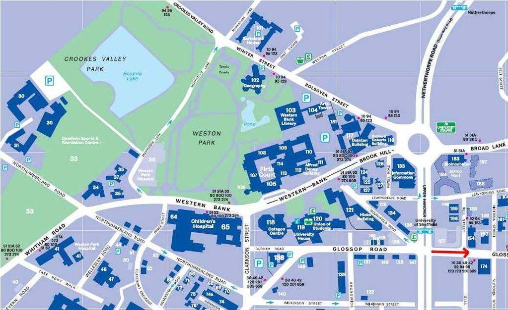
5 OTHER INFORMATION ACCOMMODATION/TRAVEL: Saturday Evening The accommodation is floor space at the sports hall at Goodwin Sports Centre, Northumberland Road, Sheffield, S10 2TY. This is marked as number 30 on the blue map below. Parking is off Northumberland Road, which can be accessed from the A57. There is some parking available next to the sports hall and this can be accessed through a barrier. Wherever you park make sure it is a busy, well lit place and that there is nothing on display in the vehicle. OPENING TIMES: We have the use of the sports hall between 5pm-8.30am. Please do not try to gain access before 5pm. In order to be in the Restaurant for the meal at 6.30pm you will need to leave the sports hall at 6pm- please shower and change quickly. FOOD: SOCIAL: The meal is at Oriental No1 Chinese Buffett (S1 2AT), at 18.30pm. Please do not be late as the restaurant will be keen to give our seats away. It is approx. 30 minutes walk from Goodwin Sports Centre. ShUOC members will be walking people from Goodwin Sports hall at 6pm. Simply follow the tram tracks down west street in the direction of the station and Oriental No1 is on the left at the bottom before the tram goes over a bridge (near ponds forge). If you get a tram, disembark at the Fitzalan Square/Ponds Forge stop. Please buy drinks in the restaurant or leave a tip as we are causing them a lot of inconvenience to book 150 seats as they would normally sell out on a Saturday. The social is in the Raynor Lounge, in the Union of Students. This is marked as number 120 on the blue map below. We will go to the social straight from the meal as we have the use of the room from 8pm. Please go to the meal dressed in your fancy dress- the theme is chavs n riot police. It would be preferable for you to deviate slightly on the theme rather than not come in fancy dress. The Raynor Lounge is accessed through a door in BarOne in the bottom of the Union. You will need a NUS card to gain access to the union else someone with a Sheffield UCard will have to sign you in. Pop Tarts for the 15 th of March this will be called O Tarts! Unfortunately the Union has put up the price of pop tarts from the advertised 3.50 to 4. Please pay the difference on collection of your tickets or you can get a refund please shuoc@shef.ac.uk by 7/3/08 if you would like a refund. DO NOT TRY TO SELL SPARE TICKETS AT THE UNION- this will get us in a lot of trouble. Please be respectful to people at the accommodation who will be asleep, and do not be rude to the staff at Goodwin. ACCOMMODATION/TRAVEL: Sunday Please tidy up after yourselves and vacate by 8.30am. Breakfast will be available upon proof of purchase (to be picked up at the individual event)
6 RELAYS: Travel Instructions The event is based at Beeley Woods, North Sheffield. This is approached from Sheffield along the A61 (Penistone Road), taking Clay Wheels Lane which leads to Beeley Wood Lane. The event will be signed from the A61 north of the junction with Leppings Lane. PARKING INFORMATION: The parking is at the end of Beeley Wood Lane. Please park on the side of the road, making sure you don t block this public road, allowing access to the factory. Please don t park in the turning circle at the bottom as this will be reserved for turning minibuses, and members of the public. For your info: Grid Reference: SK Postcode district: S6 1 Toilets - These will be available at the parking. ROUTE: In order to make this an interesting and spectator friendly event the assembly area is located in the middle of the forest. 600m from the parking area. Please follow tapes to the left of the factory building and follow the river. Turn Right uphill to cross the railway track into the assembly area. All forest except for this footpath and the assembly area is Out of Bounds.

. Spectators must not cross this line of tapes.")
7 ASSEMBLY AREA: The assembly is located in some nice open beech forest. There should be ample room for club tents and spectators. Runners will pass through the assembly area on their course and therefore tapes to the North and East will be either intermittent or placed at head height. (See map extract). Spectators must not cross this line of tapes. There are two spectator controls. The only areas that can be used for warming up are the taped off assembly area and the route to/from the parking.

8 MAPS: Steep (but fast) deciduous forest with complex mining details. Scale 1:5000, Contour Interval 5m. Drawn by Oli Johnson Courses include 2 parts and will be bagged back-to-back. These will be rolled with a sticker to seal them shut. Stickers should not be compromised before the start whistle or before you have been touched by your incoming runner. The start will be videotaped you have been warned! Control descriptions will be printed on the map. LENGTHS: Subject to final controlling: Men 6.4k, 350m climb. Women 5k, 280m climb. 1st Leg Mass Start: This will be at: 9.50 for Women for Men Please collect your map from the tent, clear your SI card and enter the waiting pen at least 5mins before your start time. You do not have to visit the start kite.
9 OUTGOING RUNNERS: Please collect your map from the tent, clear your SI card and enter the waiting pen Once inside you cannot leave, but there should be sufficient space to keep warm. INCOMING RUNNERS:1st and 2nd Legs:Touch your team mate across the tapes, punch the finish control, then download in the tent. 3rd LEGS: There will be a finish line on the ground. First to cross this line will be the winner. The adjudicator s decision is final. Then punch the finish and download in the tent. Please stay in order. PRIZE GIVING: The prize giving for the weekend will take place after the relays at the assembly area. Please return any trophies that you have long before the prize giving. OFFICIALS: Organisers- Gareth Little (ShUOC), Rach Elder (ShUOC) Planner- Neil Northrop (SYO) Controller - Charlie Adams (SYO) Map- Oli Johnson (SYO) Results- Martin Ward (SYO) ACKNOWLEDGEMENTS: Thanks to Hague Plant Ltd. for the use of Beeley Woods. SAFETY INFORMATION: Both areas contain large crags which should not be climbed down/jumped off. The nearest hospitals are Derby NHS Walk-In Centre, Entrance c, Derbyshire Royal Infirmary Site, Off Osmaston Road, Derby, Derbyshire, DE1 2RG (24 miles from the individual, not an A&E) and Northern General Hospital, Herries Road, Sheffield, South Yorkshire, S5 7AU (3 miles from the relay event, 28 miles from the Individual). It is advised that team captains should have a list of next of kin contact details in case of an emergency. People travelling alone should leave something e.g. car keys at download for safety. Please inform someone on the download team of any incidents. Please be aware that competitors take part at their own risk. ELECTRONIC PUNCHING: The electronic punching system used throughout the weekend will be SI (SportIdent). Please ask someone at download for advice if you are unsure about how to use the system. CONTACT: For any queries/questions/concerns please contact the organiser Gareth Little (between 9am- 9pm only) on

10 Map of Sheffield Google Maps- Arrow points to Goodwin Sports Centre Below is the blue map of the university campus. The red arrow shows direction to walk for Oriental No1 Chinese all you can eat Buffet.
11
INVOC Abriachan Orienteering Local Event. Sunday 10 th March 2019
 INVOC Abriachan Orienteering Local Event Sunday 10 th March 2019 Planners comments For those that are new to Abriachan the terrain is technical but physical. From a technical side of things the open hill
GRINDLEFORD GALLOP 2018
 GRINDLEFORD GALLOP 2018 Route Information The Grindleford Gallop follows a fixed 21 mile route through the lanes and paths of Derbyshire. All competitors must follow this route. An OS map of the area with
Welcome to Dale Farm Rural Campsite
 Welcome to Dale Farm Rural Campsite Thank you for booking, we are very much looking forward to welcoming you to Dale Farm and the local area. Please read the following guide as it has important information
ORIENTEERING. Allestree Park - Permanent Orienteering Course
 ORIENTEERING Allestree Park - Permanent Orienteering Course This pack consists of a map and this explanatory leaflet incorporating the control description list. The courses start at the car park on the
ISOM & ISSOM forbidden symbol comparison
 & forbidden symbol comparison Forbidden symbols and their relatives Symbol 2000 (Long, Middle) 2007 (Sprint) 201 Impassable cliff An impassable cliff, quarry or earth bank (see 106) is shown with a 0.35
IOF World Cup New Zealand January 2013 Horowhenua/Wellington/ Hawkes Bay. Bulletin 1 & 2
 IOF World Cup New Zealand 6-13 January 2013 Horowhenua/Wellington/ Hawkes Bay Bulletin 1 & 2 Welcome The New Zealand Orienteering Federation and Wellington and Hawkes Bay Orienteering Clubs invite runners
5 MAP SPECIFICATION FOR SKI-ORIENTEERING
 5 MAP SPECIFICATION FOR SKI-ORIENTEERING 5.1 General Maps for ski orienteering are based on the specifications for foot-orienteering maps. However in order to meet the specific requirements put on the
Information and Rules GMC 2016 Updated 14 th May 2016
 Information and Rules GMC 2016 Updated 14 th May 2016 Final details will be confirmed on the Grampian Orienteering Club website 1 week before the event. If the event is cancelled due to bad weather, this
HARDMOORS 55 RACE ROUTE 2018 HELMSLEY - GUISBOROUGH
 HARDMOORS 55 RACE ROUTE 2018 HELMSLEY - GUISBOROUGH HELMSLEY - CHECKPOINT 1 (WHITE HORSE) 1. Leave RACE START, continue ahead on road (Baxtons Sprunt) At crossroads turn right down Canons Garth eventualy
Below is an example of a well laid-out template of a route card used by the Sionnach Team which is a good format to begin with.
 Route Card A route card is used as a navigational aid to hill walkers by setting out a step by step plan for an intended hike. It is good practice to make out a route card before every hike you or your
HMS Unicorn. Unique Ship / Remarkable History. Access Guide for HMS Unicorn HMS Unicorn Victoria Dock Dundee DD1 3BP
 HMS Unicorn Unique Ship / Remarkable History Access Guide for HMS Unicorn 2018 HMS Unicorn Victoria Dock Dundee DD1 3BP www.frigateunicorn.org For SAT NAV directions please use our postcode 01382 200900
How to hold a bucket collection
 How to hold a bucket collection Your handy guide full of ideas and tips Bucket collections are a really simple and effective way to raise funds for Great Ormond Street Hospital Children s Charity. Take
MudCrew : The Roseland August Trail (RAT) : 2019 EVENT GUIDE
 : 2019 EVENT GUIDE") MudCrew : The Roseland August Trail (RAT) : 2019 EVENT GUIDE MudCrew presents: The Roseland August Trail (RAT) Series 2019 Thank you for interest in the 2019 Roseland August Trail (RAT) Race Series. The
MudCrew : The Roseland August Trail (RAT) : 2019 EVENT GUIDE MudCrew presents: The Roseland August Trail (RAT) Series 2019 Thank you for interest in the 2019 Roseland August Trail (RAT) Race Series. The
The 44th Annual Cambridge vs Oxford Orienteering Varsity Match
 DRONGO Orienteering Club presents The 44th Annual Cambridge vs Oxford Orienteering Varsity Match including the DRONGO vs JOK Challenge Trophy FINAL DETAILS Individual, Saturday 25th March 2017 Le rocher
The Mountains are for Everyone. Hillwalking Adventure Skill General Guidance Stages 1 to 9
 The Mountains are for Everyone Hillwalking Adventure Skill General Guidance Stages 1 to 9 Hill Walking Adventure Skills Key Elements Part of the Larger ONE programme roll out A 9 Stage Scheme from first
Control Description Sheet 1
 Control Description Sheet 1 Headings I0A Example M20 M21 M35 1 8.8km 250m Event Title Classes (optional) Course Code; Course length, Height climb Start location as if it was a control. First Control Description
Dartford Orienteering Klubb SE League and National Ranking Level B Event at Chelwood Vachery (Part of Ashdown Forest) Final Details
 Final Details") Event Date: Sunday 13 th January 2019 Dartford Orienteering Klubb SE League and National Ranking Level B Event at Chelwood Vachery (Part of Ashdown Forest) Final Details Travel : From the north at East
Event Date: Sunday 13 th January 2019 Dartford Orienteering Klubb SE League and National Ranking Level B Event at Chelwood Vachery (Part of Ashdown Forest) Final Details Travel : From the north at East
European Youth Orienteering Championships June 1 July Bulletin 2.
 European Youth Orienteering Championships 2018 28 June 1 July 2018 Bulletin 2 Sponsors Partners Become a sponsor or a partner for EYOC 2018 Write to us for more information Organizers 2 Organizers Contacts
Peak to Peak Mega Challenge FAQs
 Peak to Peak Mega Challenge FAQs Friday 27- Sunday 29 April 2018 1 The Peak District The itinerary Arrive on the Friday evening to spend the night at Losehill Youth Hostel. Your leaders will be there to
Slovenský zväz orientačných športov, Junácka 6, Bratislava. Bulletin SLOVAK PARADISE CUP 2018 GRAND PRIX SLOVAKIA 2018
 Slovenský zväz orientačných športov, Junácka 6, 832 80 Bratislava Bulletin SLOVAK PARADISE CUP 2018 GRAND PRIX SLOVAKIA 2018 National Orienteering Ranking INOV8 cup 2018 2nd and 3rd stage Date: 13. 7.
Mole Valley Orienteering Club presents. the BRITISH NIGHT CHAMPIONSHIPS. Level A Event, incorporating Round 1 of the UK Orienteering League
 Mole Valley Orienteering Club presents the BRITISH NIGHT CHAMPIONSHIPS Level A Event, incorporating Round 1 of the UK Orienteering League Saturday 22nd February 2014 FINAL DETAILS Key points: SI electronic
ID: 283 Distance: 6.2 miles Height gain: 500 Metres Map: Explore OL 19 Contributor David and Chris Stewart
 Walkingworld Wild Boar Fell ID: 283 Distance: 6.2 miles Height gain: 500 Metres Map: Explore OL 19 Contributor David and Chris Stewart Features Birds, Great Views, Hills or Fells Description: Wild Boar
Introduction to Topographic Maps
 Introduction to Topographic Maps DIRECTIONS: Read all of the following content. READ EVERYTHING!! At the end of the packet, you will find two topographic maps. Your task is to indentify each of the elevations
Property. Introduction
 This access statement does not contain personal opinions as to our suitability for those with access needs, but aims to accurately describe the facilities and services that we offer all our guests/visitors
Answers to Your Turn. Chapter 2. Maps and mapping
 Geog. 1 Answers to Your Turn Chapter 2. Maps and mapping Chapter 2.1 Mapping connections 1. A = Isle of Man; B = Northumberland; C = Cornwall; D = Surrey; E = Shrewsbury; F = Nigeria; G = Japan; H = China;
Information and Rules GMC 2018
 Information and Rules GMC 2018 Updated 3rd September 2018, following the filling of all entry spaces. New or amended information marked with Tee-Shirts We have 51 people who have registered to have an
SERBIA OPEN June 2016 Serbia BULLETIN 1-2
 SERBIA OPEN 23 26 June 2016 Serbia BULLETIN 1-2 1. Organization team SERBIAN ORIENTEERING FEDERATION Chairman: Đorđe Zagorac, president of SOF Event director: Dobrica Jelić, vice president of SOF Event
Gwynant Ltd Risk Assessment (last revision February 11 th 2013)
") Gwynant Ltd Risk Assessment (last revision February 11 th 2013) Risk Assessment Template for Llyn Gwynant Campsite Llyn Gwynant Campsite is a public campsite with toilet and shower facilities, that is
Gwynant Ltd Risk Assessment (last revision February 11 th 2013) Risk Assessment Template for Llyn Gwynant Campsite Llyn Gwynant Campsite is a public campsite with toilet and shower facilities, that is
FAQs Mill Paddock Campsite, Near Wareham, Dorset
 FAQs Mill Paddock Campsite, Near Wareham, Dorset Here is a list of FAQs about our camping trip. If you need further information, please email emma@shinecancersupport.org Has Shine done this before? Yes!
Victoria Falls Lookout to Blue Gum Forest
 Victoria Falls Lookout to Blue Gum Forest 8 hrs Experienced only 13.8 km One way 5 112m This long day-walk follows a remote track down from Victoria Falls lookout, passing the waterfall, and into the Grose
The Bridestone Rocks from Lydgate
 Print this page Back to results The Bridestone Rocks from Lydgate Ancient tracks and gritstone outcrops, with terrific views of the steepsided Cliviger Valley. Distance 5 miles (8km) Minimum time 2hrs
European Youth Orienteering Championships 2012
 Bulletin n 2 European Youth Orienteering Championships 2012 Limousin - Bugeat - FRANCE Organising Committee Orienteering Ligue of Limousin Orienteering Corrèze Club Chairman : Event Directors : Event Advisor
Access Statement for Leighton Hall
 Access Statement for Leighton Hall Introduction Leighton Hall is located 3 miles from J35 of the M6. Brown tourism signs are in situate to bring you right to the door. There is plenty of parking, with
Hindhead, Keffolds Copse and Gibbet Hill
 point your feet on a new path, Keffolds Copse and Gibbet Hill Distance: 6 km=4 miles Region: Surrey Author: Schwebefuss Refreshments: Punch Bowl Café moderate walking Date written: 14-apr-2015 Last update:
Victoria Falls and Grose Valley to Blackheath Station
 This walk explores a fantastic section of the Grose Valley. Starting above Victoria Falls, the walk explores the cascades before dropping into the valley for the first nights rest at Burra Korain campsite.
Property. Introduction. Pre-Arrival
 This access statement does not contain personal opinions as to our suitability for those with access needs, but aims to accurately describe the facilities and services that we offer all our guests/visitors
Leaden Boot Challenge ROUTE INSTRUCTIONS
 Leaden Boot Challenge ROUTE INSTRUCTIONS Section 1 Alstonefield to Ilam From the village hall car park turn R then L and pass through the village keeping to the R to enter Church Street. Pass the Church
Camp Jack Wright PERMANENT ORIENTEERING COURSE (2004)
") Camp Jack Wright PERMANENT ORIENTEERING COURSE (2004) WHAT IS ORIENTEERING? The skill which enables a person to navigate with a map. In the competitive sport, the winner is the person who finishes in the
Camp Jack Wright PERMANENT ORIENTEERING COURSE (2004) WHAT IS ORIENTEERING? The skill which enables a person to navigate with a map. In the competitive sport, the winner is the person who finishes in the
We are delighted to confirm your booking to stay overnight at Lookout Lodge, nestled at the heart of ZSL Whipsnade Zoo.
 We are delighted to confirm your booking to stay overnight at Lookout Lodge, nestled at the heart of ZSL Whipsnade Zoo. The ultimate overnight experience a once in a lifetime chance to live next door to
A GUIDE TO ORGANISING YOUR Great British Spring Clean event THE #GBSPRINGCLEAN
 A GUIDE TO ORGANISING YOUR Great British Spring Clean event THE Great British Spring Clean #GBSPRINGCLEAN 02 keepbritaintidy.org Contents Preparation 4 Got it all mapped out? 4 Who wants to get involved?
Access Guide READING FESTIVAL 2018
 Access Guide READING FESTIVAL 2018 CONTENTS WHERE TO GO WHEN YOU ARRIVE... 2 ARENA OPENING TIMES... 3 TRAVEL TO SITE... 3 DISABLED ACCESS CAMPSITE CUSTOMERS... 4 RECYCLING... 6 ARENA... 8 VIEWING PLATFORM
SEPTEMBER 25-27, OTEPÄÄ ESTONIA
 EUROMEETING 2015 BULLETIN 1 XXVII SUUNTO GAMES in Estonia 26.09. - 27.09.2015 Kirikuküla 26.09 Long distance 27.09 Shortened long distance Dear orienteering friends! It's my pleasure to welcome you to
Access Statement for Tom's Field Campsite and Shop
 This access statement does not contain personal opinions as to our suitability for those with access needs, but aims to be as describe the facilities and services that we offer to our visitors. Access
DERWENT HILL CAMPSITE
 DERWENT HILL CAMPSITE Thank you for booking the Derwent Hill Campsite. This is a simple site designed primarily for use by supervised groups of young people. We hope you enjoy your stay. This document
Measurements, Weight and Pictures Please read all of this, will take you 5 minutes. : )
") Measurements, Weight and Pictures Please read all of this, will take you 5 minutes. : ) Below is the information for how you submit your measurements to track your progress and your pictures for the 6-week
Measurements, Weight and Pictures Please read all of this, will take you 5 minutes. : ) Below is the information for how you submit your measurements to track your progress and your pictures for the 6-week
Chirk Castle is 2 miles from Chirk village, in the county of Wrexham.
 Chirk Castle is open from 3 February to 4 November in 2018. We are also open on November weekends and from 8 to 23 December. Outside of these dates Chirk Castle is closed to visitors. To check exactly
Leaden Boot Challenge 2016 ROUTE INSTRUCTIONS
 Leaden Boot Challenge 2016 ROUTE INSTRUCTIONS Section 1 Alstonefield to Ilam (CP2) From the village hall car park turn R then L and pass through the village keeping to the R to enter Church Street. Pass
Trek the highest mountain in Africa. Mt Kilimanjaro. for a trip of a life time!
 Trek the highest mountain in Africa Mt Kilimanjaro for a trip of a life time! Trip outline The expedition offers you the challenge of trekking the highest free standing mountain in the world and Africa
LAKE NEEDWOOD ORIENTEERING MEET QUANTICO ORIENTEERING CLUB SEPTEMBER 18, 2011
 NATIONAL ORIENTEERING DAY LAKE NEEDWOOD ORIENTEERING MEET QUANTICO ORIENTEERING CLUB SEPTEMBER 18, 2011 COMBINED EVENT NOTES, including: National Orienteering Day Course Designer s Notes Super String-O
First Aid. Welcome to the Walkatjurra Walkabout Induction Booklet
 Welcome to the Walkatjurra Walkabout Induction Booklet This booklet has been written to give you an idea of what to expect when you go on the walk. It s based on our experiences from previous walks. Remember
Scenic Railway to Ruined Castle
 Scenic Railway to Ruined Castle 7 hrs 30 mins 12.4 km Return Hard track 4 963m This is a very popular, full day walk, in the Katoomba Area, offering great views of the valley. The walk follows the edge
Residential - Pre-Expedition Information Pack & Kit List
 Residential - Pre-Expedition Information Pack & Kit List Location & time: The Lake, H5 Adventure Ltd, South Farm, Thornhill, Royal Wootton Bassett, SN4 7RX. ALL SAT NAVs do not take you to the venue. PLEASE
Information & Joining Instructions
 Information & Joining Instructions The following information is intended as a general guide for Conference Delegates, Dinner Guests and Exhibitors alike. If we have missed anything, please use the contact
Our Adventure Awaits Diamond Cruise March 2017
 Our Adventure Awaits Diamond Cruise 11 18 March 2017 Only 3 months to go until we board the Diamond Cruise! It s getting closer! Welcome to the second issue of our 2017 Lifeplus Diamond Cruise Newsletter.
Immediately inform a member of staff or Event Team. They will initiate the appropriate procedures.
 GROUP LEADERS Welcome to Wintercamp The Staff and Service Team welcome you to Wintercamp, and hope that you will have an enjoyable weekend. In the interests of safety please ensure that everyone in your
Welcome to Worthy View!
 Welcome to Worthy View! We hope you will really enjoy staying with us over the Festival. In order to get the most out of your stay, please have a look at the information provided in this pack and keep
Beautiful Walks from the Blue Ball Inn
 Walk No. 2 WINSTONS WALK Countisbury, Wind Hill, Watersmeet, Ash Bridge and Winston s path. 5 Miles approx. Walking time- Two and a half hours approx. (Not including Breaks) OS 1:25,000 Sheet 64/74 Lynton
WELCOME INFORMATION PACKET
 WELCOME INFORMATION PACKET For guests staying with us here at YWAM Sydney Island Breeze To see this generation transformed and mobilised into their God-given destiny. WELCOME TO YWAM SYDNEY ISLAND BREEZE!
Beautiful Walks from the Blue Ball Inn
 Walk No. 5 RIVER VALLEYS AND MOOR Countisbury, Watersmeet, Hillsford Bridge, Cheriton, Shilstone Hill, Rockford and Chiselcombe. 8.5 MILES APPROX. Walking time four and a half hours approx. OS 1;25,000
BULLETIN 2. 6 th South East European Masters Orienteering Championships ŽABLJAK-MONTENEGRO
 BULLETIN 2. 6 th South East European Masters Orienteering Championships ŽABLJAK-MONTENEGRO 23-27 th august 2017 ORGANIZER: Montenegro Orienteering Federation PARTNERS: International Orienteering Federation
Back Up s Snowdon Push Friday 30 th June Sunday 2 nd July 2017
 Back Up s Snowdon Push Friday 30 th June Sunday 2 nd July 2017 Essential information & application pack The aim of this fantastic fundraising challenge event is to raise over 50,000 (net) for Back Up.
Self-Guided Walk Malham, Gordale and Malham Tarn
 Self-Guided Walk Malham, Gordale and Malham Tarn Combine all the major geological attractions of Malham in this walk and hopefully leave enough time to enjoy the cafes, pubs and shops of the village. Malham
The Atlas of Hillforts of Britain and Ireland. Hillfort survey notes for guidance
 The Atlas of Hillforts of Britain and Ireland Hillfort survey notes for guidance The collection of surveys for the Atlas is now finished but you can use this form and the accompanying Notes for Guidance
YOUR GUIDE TO A GREAT BREAK IN MINEHEAD
 YOUR GUIDE TO A GREAT REAK IN MINEHEAD EFORE YOU ARRIVE Hello! There s not long to go until you join us in Minehead, so we thought we d get in touch with a little reminder of your booking details, as well
Airport Awareness. Travel advice for parents and carers of children on the Autistic Spectrum
 Airport Awareness Travel advice for parents and carers of children on the Autistic Spectrum Tel: 0845 070 4004 nas@nas.org.uk We have created this book in conjunction with advice from the National Austic
YHA Malham Access Statement
 YHA (England & Wales) Trevelyan House, Dimple Road, Matlock, Derbyshire, DE4 3YH Tel. +44(0)1629 592 700 www.yha.org.uk YHA Malham Access Statement Introduction walking the Pennine Way, or just looking
START - UPHILL BEACH. (tidal!) The West Mendip Way is route-marked with these round blue signs
 The West Mendip Way is route-marked with these round blue signs") START - UPHILL BEACH Start Times: 10:30 11:15 12:00 Please allow sufficient time to check in with the marshals Start on the beach at the high water line (tidal!) The West Mendip Way is route-marked with
START - UPHILL BEACH Start Times: 10:30 11:15 12:00 Please allow sufficient time to check in with the marshals Start on the beach at the high water line (tidal!) The West Mendip Way is route-marked with
SICK SCIENCE. Patuxent District Fall Camporee November 2-4, 2018 American Legion Youth Camp 9201 Surratts Road Cheltenham, Maryland 20623
 SICK SCIENCE Patuxent District Fall Camporee November 2-4, 2018 American Legion Youth Camp 9201 Surratts Road Cheltenham, Maryland 20623 Version 2.0 Updated 8-16-2018 SICK SCIENCE Join us for Science Fun
BATTLE OF BRADFIELD ROAD BOOK 2018
 BATTLE OF BRADFIELD ROAD BOOK 2018 Welcome to the Event Guide for the 2018 Battle of Bradfield on Sunday 18/3/18 which starts and finishes in Stannington, Sheffield - this guide will tell you all you need
Dear Sonisphere customer
 Dear Sonisphere customer It s only a few weeks till Sonisphere so to help grow the excitement we thought we would send you some information that we recommend you read before you set out so that you can
Basic Bushwalking Skills Certificate. Assessment Package
 Basic Bushwalking Skills Certificate Assessment Package Basic Bushwalking Skills Aligning with National Outdoor Recreation Modules E:\Contract Work\Andrew Govan\Bushwalking Leadership\2015-09-11 Basic
Lordenshaw. What are cup & ring marks?
 Lordenshaw Lordenshaw hill has one of the largest clusters of ancient cup and ring marked stones in the UK. We ve chosen four interesting spots we d like to share with you. What are cup & ring marks? The
10 th World Rogaining Championships 2012 Organizers' Report
 10 th World Rogaining Championships 2012 Organizers' Report August 2012 Our WRC 2012 course is virtually planned; all the checkpoints have been marked and inspected by vetters. All of them say everything
Terminal 3. Arrivals Guide. Preparing for travel. Travel advice for anxious passengers
 Terminal 3 Arrivals Guide Preparing for travel Travel advice for anxious passengers About this guide Sections About this guide Finding your way around Terminal 3 Sensory awareness What you can expect Information
The resignalling scheme
 & Nottingham Resignalling scheme The resignalling scheme What work is being carried out? s well as redeveloping the station, Network Rail is rebuilding the rail infrastructure around the city. The 100m
Haworth Tr T avel Plan r 10th February 2006
 Haworth Travel Plan 10th February 2006 Haworth Travel Plan has been prepared for: Contents 1 Why have Haworth Travel Plan?... 3 2 Who will benefit from Haworth Travel Plan?... 4 3 What actions will be
24 26 th October 2014
 24 26 th October 2014 Are you up for a challenge? Pen y ghent We are inviting all Coventry Explorers, together with the Jamboree contingent from Coventry, Leicester and Derby, to complete a walking challenge
ASHWORTH VALLEY SCOUT CAMP SITE
 ASHWORTH VALLEY SCOUT CAMP SITE BOOKING CONDITIONS Pricing Charges are reviewed on 1 st April each year. Any advance booking will be adjusted to prices applicable at the date of use (not the date of booking).
Templars Park Management Committee ( TPMC ) Detailed Guidelines & Rules GUIDELINES FOR USERS
 Detailed Guidelines & Rules GUIDELINES FOR USERS") ( TPMC ) GUIDELINES FOR USERS Aberdeen District Scout Council welcomes you to Templar s Park Scout Campsite. The site is run with as few restrictions as possible but there are a number of rules and guidelines
( TPMC ) GUIDELINES FOR USERS Aberdeen District Scout Council welcomes you to Templar s Park Scout Campsite. The site is run with as few restrictions as possible but there are a number of rules and guidelines
Trail Phasing Plan. Note: Trails in the Clear Creek Canyon area (Segments will be finalized in the future to minimize wildlife impacts
 Note: Trails in the Clear Creek Canyon area (Segments 2 5 and a future JCOS connection) will be finalized in the future to minimize wildlife impacts Trail Phasing Plan P Parking 3 Easy Trail Intermediate
THE CARAVAN AND MOTORHOME CLUB NORTH LANCASHIRE CENTRE GUIDANCE FOR RUNNING RALLIES FOR RALLY OFFICERS (REVISED EDITION FEBRUARY 2018)
") THE CARAVAN AND MOTORHOME CLUB NORTH LANCASHIRE CENTRE GUIDANCE FOR RUNNING RALLIES FOR RALLY OFFICERS (REVISED EDITION FEBRUARY 2018) RALLY OFFICERS The Rally Officer must be Centre Member. However, it
THE CARAVAN AND MOTORHOME CLUB NORTH LANCASHIRE CENTRE GUIDANCE FOR RUNNING RALLIES FOR RALLY OFFICERS (REVISED EDITION FEBRUARY 2018) RALLY OFFICERS The Rally Officer must be Centre Member. However, it
4 September 2016 Welcome the the last Newsletter before the event. Hope all the preparations are coming along well.
 Newsletter #4 4 September 2016 Welcome the the last Newsletter before the event. Hope all the preparations are coming along well. SECRETARIES OFFICE This will be located in the Green and Gold Caravan -
Satisfying the Need: Finding Potential Campsite Locations in Farewell Canyon, B.C. Alexis Moore
 Satisfying the Need: Finding Potential Campsite Locations in Farewell Canyon, B.C. Alexis Moore 230075923 Geog 413 Final Project Write- Up Roger Wheate April. 13, 2012 Introduction & Purpose of Study The
Terminal 4. Arrivals Guide. Preparing to travel. Travel advice for anxious passengers
 Terminal 4 Arrivals Guide Preparing to travel Travel advice for anxious passengers About this guide Sections About this guide Finding your way around Terminal 4 Sensory awareness What you can expect Information
On Board. Looking forward now to our weekend at Carsington Water and the Mystery Trip and the many more events in the pipeline.
 Friendship Cruising Club s Newsletter On Board Issue No 30 September 2016 A message from Captain Sandra Our Masquerade Summer Ball Hello Folks! This is our 30 th Edition of On Board and looking back at
4.1 Landforms. Note: dimensions are specified in mm at the scale of 1: All drawings are at 1:7 500 for clarity only.
 4.1 Landforms Note: dimensions are specified in mm at the scale of 1:15 000. All drawings are at 1:7 500 for clarity only. OM = Outside measure IM = Inside measure CC = Centre to centre 0.2 0.4 OM 0.4
Thanks for Volunteering at Run or Dye Penshurst Place, Penshurst!
 Thanks for Volunteering at Run or Dye Penshurst Place, Penshurst! We re so happy that you re going to be a volunteer with Run or Dye. This info pack will share all the details you need to make sure you
MT ARTHUR CHALLENGE SPONSORSHIP PROSPECTUS.
 MT ARTHUR CHALLENGE Promoting physical fitness, the beautiful Mt Arthur Reserve and supporting the local community. SPONSORSHIP PROSPECTUS 2018 www.mtarthurchallenge.org.au EVENT INFORMATION The Mt Arthur
3 PEAKS CHALLENGE INFO PACK
 THE THREE PEAKS CHALLENGE! This involves scaling the three highest peaks in Wales, England and Scotland - Snowdon, Scafell Pike and Ben Nevis. The attempt on these mountains is known as the three peaks
Risk Assessment. This risk assessment is fully reviewed on and annual basis. Amendments and additions are incorporated as required.
 KICC is a camping and activity centre located in Kingsdown, Nr Deal, Kent. Set in 40 acres of sloping open grassland the estate enjoys woodland boundaries and unparalleled sea views across the English
Barton on Sea. Owned by: New Forest District Council Wind Direction SW SE (135 to 225 ) Best: S (180 )
 Best: S (180 )") OS Grid Ref: SZ 242 929 (Map 195) GPS: N50:44.113 W1:39.507 Owned by: New Forest District Council Wind Direction SW SE (135 to 225 ) Best: S (180 ) Nearest Phone: Casualty Units: Junction of Marine drive
OS Grid Ref: SZ 242 929 (Map 195) GPS: N50:44.113 W1:39.507 Owned by: New Forest District Council Wind Direction SW SE (135 to 225 ) Best: S (180 ) Nearest Phone: Casualty Units: Junction of Marine drive
The Masterplan. This is our report from the first phase of consultation.
 GLEADLESS VALLEY The Masterplan We have been given funding by central Government to develop a masterplan for Gleadless Valley. A masterplan looks at everything to do with an area including housing, open
Access Statement for Rand Farm Park
 Access Statement for Rand Farm Park Introduction Rand Farm Park offers a high quality hands on fun and learning experience for all ages and abilities Large variety of animals to hold, feed, touch and cuddle
Here s a stack of useful information to help everything run smoothly for you and everyone.
 CREW ESSENTIAL GUIDE 2015 Thanks for being a part of the amazing community that Shambala is without you all we d be sitting in an empty field, roasting a rabbit for dinner. You re great! Here s a stack
ROTARY DISTRICT 1220 AUGUST 2015 ON THE MOVE! Ey Up Mi Duck
 ROTARY DISTRICT 1220 AUGUST 2015 ON THE MOVE! The Rotary clubs in District 1270 voted in June this year that District 1270 should disband. The Clubs in 1270- have until the 31 st August 2015 to make the
Joining instructions. Women s Conference th - 30 th March St Johns Hotel, Solihull
 Joining instructions Women s Conference 2017 28 th - 30 th March 2017 St Johns Hotel, Solihull Venue and arrival Name and address of venue: The St Johns Hotel 651 Warwick Road, Solihull, West Midlands,
Getting Here Our address is:
 Accessibility Guide for King Richard III Visitor Centre (October 2018) Email: info@kriii.com Telephone: 0300 300 0900 Website: www.kriii.com Contact for accessibility enquiries: Rachel Ayrton Welcome The
Bewl Water & the High Weald
 1 Bewl Water & the High Weald Stonegate station - Stonegate - Wallcrouch - Newbarn - Cousley Wood - Wood's Green - Wadhurst station Length: 9 ½ miles (15.3km) Underfoot: Large portions of this path are
Lookout Lodge Guest Information Pack 2017
 Lookout Lodge Guest Information Pack 2017 We are delighted to confirm your booking to stay overnight at Lookout Lodge, nestled at the heart of ZSL Whipsnade Zoo. The ultimate overnight experience a once
Minimum Knowledge Expected of Learner
 Unit 1 Developing outdoor leadership skills Know the roles and responsibilities of an Assistant Basic Expedition Leader. Be able to apply the skills of an Assistant Basic Expedition Leader. Know the importance