PARKS & RECREATION MASTER PLAN
|
|
|
- Derick Byrd
- 5 years ago
- Views:
Transcription


1 McKinleyville Community Services District Department of Parks & Recreation PARKS & RECREATION MASTER PLAN 2012 Adopted May 2, 2012
2 Table of Contents Acknowledgements 1 Chapter One: Introduction 3 Introduction 4 Purpose of the plan 4 Setting 4 Definitions 5 Summary of Recommendations 6 Chapter Two: Inventory of Existing Opportunities 8 Overview 9 Existing Parks and Facilities 9 Additional Recreation Facilities 11 Trails 12 Open Space 13 Undeveloped Land 14 Recreation and Cultural Programs 15 Summary 15 Chapter Three: Recreational Standards 16 Overview 17 Recreation Facility Standards 17 Chapter Four: Description of Unmet Needs 19 Overview 19 Additional Facilities Needed 20 Chapter Five: The Plan 26 Overview 27 Policies and Objectives 27 Five Year Plan 29 Twenty Year Plan 30 Chapter Six: Implementation of the Plan 32 Overview 33 One Year Program 33 Plan Update Process 34 Appendices 35 Appendix A Humboldt County Trails Plan 35 Appendix B Potential New Trail Routes 40 McKinleyville Community Services District Parks and Recreation Master Plan
3 Table of Contents Exhibits Planning Area Map Existing Recreational Opportunities Map of Existing Facility Locations Recreational Facilities Inventory Recreational Facility Standards Current Facility Requirements Projected 2021 Recreational Facility Requirements Facilities Proposed to be supported by MCSD funding Measure B Survey Results Summary Facilities Proposed to Satisfy Future Unmet Needs Humboldt County Map Organizational Chart Open Space Maintenance Zone Listing 69 McKinleyville Community Services District Parks and Recreation Master Plan
4 Chapter One: Introduction Chapter 1: Introduction McKinleyville Community Services District Parks and Recreation Master Plan
.")
5 Chapter One: Introduction Introduction The McKinleyville Community Services District (MCSD) s Parks and Recreation Master Plan is intended to be a list of priorities for and strategies by MCSD for providing recreational facilities and programs to the 12,000 acre area inside the McKinleyville Community Services District (See Exhibit 1). The Plan should provide a blueprint of what the District intends to provide in the way of recreation for McKinleyville by the year 2031 with the understanding that the needs of the community and its resources will change over time. Therefore, the plan will need to be updated at least every five years to reflect new conditions and expectations. Chapter Two describes the recreational opportunities available to McKinleyville in Chapter Three describes the expanded set of facilities and programs the community would expect of the District if funding were available. Chapter Four identifies the needs not met by the existing opportunities and Chapter Five proposes new facilities and programs to meet those needs. Chapter Six describes the actions by the District needed to realize the short-term (5 year) objectives of the plan, ending Purpose of the Plan As stated above, this plan will provide McKinleyville with a strategy for achieving MCSD s highest priority projects. This is a planning tool, (not a strict guideline) for use by the residents of McKinleyville, the MCSD Recreation Advisory Committee, and the MCSD staff and Board of Directors. For residents, the plan may serve as a catalog of recreational opportunities and as a source of information. For the MCSD Recreation Advisory Committee, the plan will focus development efforts on MCSD s high priority projects. For the MCSD staff and Board of Directors, the plan will serve as the basis for funding decisions and grant applications. Setting McKinleyville is an unincorporated community of approximately 15,000 people. Exhibit 1 illustrates the boundaries of the McKinleyville Community Services District that encompasses 12,000 acres. Most of the housing is located in the 4,000 acre rectangle formed by the Pacific Ocean, the Mad River, the foothills and the airport. Commercial activities are concentrated along Central Avenue from School Road to Murray Road. Growth in McKinleyville has been moderate since The estimated annual population growth is approximately 1.8%. According to the MCSD Urban Water McKinleyville Community Services District Parks and Recreation Master Plan

6 Chapter One: Introduction Management Plan population in McKinleyville should increase to 17,000 people by the year Demographics The 2010 United States Census reported that McKinleyville had a population of 15,177. The population density was people per square mile. The racial makeup of McKinleyville was 13,010 (85.7%) White, 103 (0.7%) African American, 700 (4.6%) Native American, 211 (1.4%) Asian, 17 (0.1%) Pacific Islander, 338 (2.2%) from other races, and 798 (5.3%) from two or more races. Hispanic or Latino of any race were 1,081 persons (7.1%). The Census reported that 15,098 people (99.5% of the population) lived in households, 79 (0.5%) lived in non-institutionalized group quarters, and 0 (0%) were institutionalized. There were 6,283 households, out of which 1,979 (31.5%) had children under the age of 18 living in them, 2,784 (44.3%) were opposite-sex married couples living together, 691 (11.0%) had a female householder with no husband present, 386 (6.1%) had a male householder with no wife present. There were 619 (9.9%) unmarried opposite-sex partnerships, and 58 (0.9%) same-sex married couples or partnerships. 1,731 households (27.6%) were made up of individuals and 515 (8.2%) had someone living alone who was 65 years of age or older. The average household size was There were 3,861 families (61.5% of all households); the average family size was The population was spread out with 3,452 people (22.7%) under the age of 18, 1,349 people (8.9%) aged 18 to 24, 4,306 people (28.4%) aged 25 to 44, 4,189 people (27.6%) aged 45 to 64, and 1,881 people (12.4%) who were 65 years of age or older. The median age was 36.3 years. For every 100 females there were 95.9 males. For every 100 females age 18 and over, there were 93.6 males. There were 6,565 housing units at an average density of per square mile, of which 3,770 (60.0%) were owner-occupied, and 2,513 (40.0%) were occupied by renters. The homeowner vacancy rate was 1.1%; the rental vacancy rate was 2.7%. 9,459 people (62.3% of the population) lived in owneroccupied housing units and 5,639 people (37.2%) lived in rental housing units. Definitions Select terms as used in this plan are defined as follows: Active Recreation: Involves organized and structured sports such as soccer, baseball and tennis. Bicycle Path: Describes a bikeway physically separated from motorized vehicular traffic, either within a road right of way or within an independent right of way. Bicycle paths should be distinguished from bicycle lanes or routes which share roadways with motorized vehicles. Bicycle Paths and Lanes are primarily established for non-motorized circulation as compared to recreation purposes. The Bicycle Lanes on the East and West side of Central Avenue from School Road to Railroad Avenue are examples. McKinleyville Community Services District Parks and Recreation Master Plan

7 Chapter One: Introduction Community Park: Describes a recreational area of six plus acres available to the entire District service area. Mini Park: Describes a recreational area of less than two acres serving the area encompassed inside a 1 mile radius. Other Park: Describes a recreational area of between 2 acres and 5 acres. Neighborhood Park: Describes a recreation area of 5 acres serving the area encompassed in a 2 mile radius. Playground: Describes a defined play area intended for use by older children (6-12 years); equipped with active play structures and fall absorbing footing material. Preservation Area: Describes a property that excludes or restricts public use to protect ecological, cultural or natural values. Open Space: Describes undeveloped or reclaimed land preserved for public use for its cultural, ecological visual, educational or recreational significance. Passive Recreation: Encompasses such unstructured, relatively quiet activities as picnicking, bird watching, kite flying and walking. Perennial Stream: Describes a stream that flows year round as compared to an intermittent stream that flows for a portion of the year or an ephemeral stream that only flows during a storm. Riparian Habitat: Describes the plant and wildlife community associated with stream-sides or wetlands. McKinleyville Community Services District Parks and Recreation Master Plan
8 Chapter One: Introduction Tot Lot: Describes a defined play area intended for use by young children (1-5 years); equipped with play equipment, make believe settings and fall absorbing footing material. Trail: Describes a route that is designated for recreational use for one or more forms of transportation other than motor vehicles. Trails are primarily established for recreational activity as compared to circulation purposes. The nature trail from Parkside Drive to Widow White Creek is an example. Undeveloped Land: Describes a vacant property held in private ownership. Useable Open Space describes a dedicated permanent play surface for recreational opportunities and/or informal sports activities. Watershed: Describes a drainage basin, the area of land from which a stream gets its water supply. McKinleyville Community Services District Parks and Recreation Master Plan
9 Chapter Two: Inventory of Existing Opportunities Chapter 2: Inventory of Existing Opportunities McKinleyville Community Services District Parks and Recreation Master Plan


10 Overview Chapter Two: Inventory of Existing Opportunities McKinleyville is blessed with abundant natural beauty given our proximity to the Pacific Ocean, the Mad River, and several types of coniferous forests. Several lovely streams cross from the foothills to the ocean and native azaleas flourish in many areas throughout the community. The State of California, the County of Humboldt and the MCSD own and operate a wide variety of parks and facilities. Additionally, MCSD, the McKinleyville Union School District, the Northern Humboldt Unified High School District, numerous non-profit organizations and a handful of businesses provide recreational access. These opportunities are summarized in Exhibit 2 and cataloged in the following sections. Existing Parks and Facilities (other agencies) McKinleyville residents have access to the several parks that are managed by other agencies, as listed below: Azalea State Reserve is operated by the State of California and consists of a 30 acre natural area located in the South East corner of McKinleyville. The Park features the native Western Azalea, and Rhododendron, which blooms during spring. Facilities at the Park include a self- guided nature trail, two picnic areas, a grass play area, seasonal restrooms and parking. Little River Beach State Park is operated by the State of California and consists of a 112 acre strip of land sandwiched between Highway 101 and the Pacific Ocean at the North End of McKinleyville. The park offers over a mile of beach for sightseeing, beachcombing, clamming, fishing and hiking. Clam Beach County Park is operated by the County and consists of the 250 Acres on the coast south of the Little River Beach State Park to Widow White Creek. With more than three miles of beach the area has historically been a popular recreational destination for McKinleyville residents. Facilities at the park include camping sites, restrooms, parking and an equestrian use area. Mad River County Park is operated by the County and occupies a triangular spit of sand formed by the Mad River on the East and the Pacific Ocean on the West. The 91 acre park is a haven for fishermen and boaters with access into both the Mad River and the Pacific Ocean. Facilities at the Park include a boat ramp, restrooms, trails, picnic McKinleyville Community Services District Parks and Recreation Master Plan
 MCSD operates Hiller Park, Hiller Sports Complex, Pierson Park, Hewitt Ranch, and Larissa Park.")
11 Chapter Two: Inventory of Existing Opportunities tables and parking. Mad River County Park is located across the Mad River (west side) from McKinleyville. Existing Parks and Facilities (MCSD) MCSD operates Hiller Park, Hiller Sports Complex, Pierson Park, Hewitt Ranch, and Larissa Park. Hiller Park is located at the west end of Hiller Road, is a 36 acre natural area with trails, meadows and woods. Adjacent to the Hammond Trail, the restrooms at Hiller Park serve the day users and the cyclists, hikers and riders using the trail. Hiller Park also has a group barbecue area including picnic tables, and two tot lots for kids ages There is a large meadow area that is a popular destination for dog owners. Hiller Sports Complex includes two little league fields, one regulation sized softball field, one minor softball field, a Babe Ruth baseball field that doubles as a regulation softball field, and two collegiate size soccer fields. Pierson Park is a 6.2 acre site with a community center located east of Central Avenue between Pickett Road and Gwin Road. Pierson Park includes two playgrounds including a climbing rock, a group barbecue complex, picnic grounds, three horseshoe pits, two bocce ball courts, a community garden, restrooms and parking. The McKinleyville Library is located in Pierson Park and maintained by the District and operated by the County. In 2010, the McKinleyville Library was expanded to include a 720 square foot conference room equipped with Wi-Fi. Azalea Hall is a 6,820 square foot Community Center located in Pierson Park. Overlooking Pierson Park, Azalea Hall includes a 2,000 square foot Hewitt Room, which features natural wood-beamed ceilings, adjustable lighting, a stage and sound system, projector screen, and a fully equipped commercial kitchen. It seats up to 200 persons for banquets and 300 in assembly. Azalea Hall also features a Meeting Room, which is an ideal place for small, quiet group meetings. It has a seating capacity of 50 persons for banquets and 75 in assembly. It is situated within our Senior Room, and is generally available after 4:00 pm each day. McKinleyville Activity Center is a gymnasium located in Pierson Park. The facility is 10,000 square feet, featuring a full-size gymnasium, bleachers, a spacious lobby, a sound system, and a variety of indoor sporting equipment (including roller skates). This facility is ideal for sporting events, birthday parties, gatherings and larger special events and fundraisers. The Law Enforcement Facility is located adjacent to the library in Pierson Park. McKinleyville Community Services District Parks and Recreation Master Plan
12 Chapter Two: Inventory of Existing Opportunities Larissa Park is a 0.17 acre mini-park located West of Central Avenue off of Reasor Road. Larissa Park has a tot lot playground for kids age 2-5, a grassy area, and picnic tables. Hewitt Ranch is a 14 acre site off Azalea Road that is currently undeveloped, but is available to the public for passive recreation. It is a beautiful forested area with a few small creeks and a few relatively small grassland areas. A 3 Acre property at School Road and Washington Avenue was purchased in This area will be developed for recreational use in the future. Added together, the parks described above total more than 540 acres of recreational opportunities. Additional Recreational Facilities In addition to the parks described above, McKinleyville residents have access to the following public and private facilities some of which afford recreational possibilities: Vista Turnout: The State of California maintains a five acre Vista Turnout between Highway 101 and Clam Beach. Roping Arena: Humboldt County leases a roping arena and gymkhana grounds at the North end of Kjer Drive to the McKinleyville Rodeo Association. Hammond Bridge River Access: Humboldt County maintains a parking area on the North bank of the Mad River adjacent to the Hammond Bridge abutment. North bank River Access Humboldt County also owns an undeveloped parcel of 3.3 acres between North Bank Road and the Mad River that is used by Fishermen to walk to the river bank. Dows Prairie School: McKinleyville Union School District (MUSD) issues permits to individuals and groups to use their playing fields and gym for active recreation including soccer, football, baseball, softball and basketball. MUSD also issues permits for use of the multi-purpose room and audiovisual center for community meetings and events. McKinleyville Middle School: MUSD issues permits to individuals and groups to use their playing fields and gym for active sports and multi-purpose room for community meetings and events. Morris School: MUSD issues permits to individuals and groups to use their playing fields and gym for active sports and multi-purpose room for community meetings and events. McKinleyville Community Services District Parks and Recreation Master Plan


13 Chapter Two: Inventory of Existing Opportunities McKinleyville High School: Northern Humboldt Union High School District occasionally contracts for use of their fields and rooms. Beau Pre Golf Course: Beau Pre is a privately owned golf course open to the public on a fee basis. Meeting Space: In addition to the schools, community meetings may be held at the MCSD Office, the Chamber Office, the Grange Hall, the Eureka/Arcata Airport, the McKinleyville Library, and the MCSD conference Room, Azalea Hall, the McKinleyville Shopping Center, Six River National Bank and at several of the churches in the community. Trails The State provides hiking opportunities at both the Azalea Reserve and at Little River State Beach. At Azalea Reserve there are two 0.3 mile looped, interpretive trails through the native azalea grove. At Little River State Beach hikers and equestrians can access over one mile of ocean frontage. The Hammond Trail is a 12 foot wide separated path running from the Arcata Bottoms to Clam Beach. From the Mad River at the Hammond Bridge to its north terminus the trail is about 3 miles long. The Hammond Trail is a very popular trail used by hikers and cyclists. Humboldt County has also constructed a river access spur trail off of the Hammond Trail just north of Murray Road. Construction of two additional miles from the north side of Widow White Creek to Clam Beach was recently completed. Humboldt County also provides hiking and equestrian access at Clam Beach County Park and Mad River County Park. See Exhibit 16 for a map of Humboldt County Parks. MCSD provides a 0.6 mile looped nature trail at Hiller Park that circles the wastewater treatment facility from the Hammond Trail. The Mid Town Trail is partially constructed from Parkside Drive to Railroad Drive, about 0.4 of a mile. The southern portion south of School Road has been constructed in the Murrish Subdivision (0.1 mile). The central section of.5 miles will be completed as McKinleyville Community Services District Parks and Recreation Master Plan

14 Chapter Two: Inventory of Existing Opportunities properties are developed. This is a paved bicycle and pedestrian path that will eventually link Murray Road to the Mill Creek Marketplace. MCSD maintains a 0.3 mile trail on the south side of School Road from Fischer Road to the Mad River Bluff. This is a paved bicycle and pedestrian trail. The County provides bike lanes along portions of Central Avenue, School Road, McKinleyville Avenue, Murray Road and Hiller Road. The McKinleyville Land Trust provides trails west of the Hiller Park Loop Trails. This trail system has recently been improved and allows for coastal access. Open Space MCSD and the McKinleyville Land Trust Land has been preserving land as open space since For MCSD s open space lands, they are available for passive recreation, but no overnight camping, and no motorized vehicles are allowed in them. This is also largely true of the McKinleyville Land Trust s lands, but readers should check with the land trust for specific rules and regulations of their properties. In 1991, the MCSD Board adopted Ordinance 42 that enabled the District to accept donations of open space land or easements predicated on the formation of an assessment district to pay for long-term maintenance of that open space. Since 1991, the following open space resources have been preserved: North Fork Wetland: MCSD holds an easement interest in the 2-acre wetland and riparian habitat adjacent to the North Fork of Widow White Creek North of Little Pond Drive. Ridgewood Wetland: MCSD holds an easement interest in the 2-acre wetland located in the North West corner of the Ridgewood Subdivision (North of Sutter Road). The wetland is related to natural springs in that area. McLund/Norton Creek Wildlife Area Wetland: MCSD owns a 1.59-acre wetland and pond located in the McLund Subdivision south of Barnett Road between Winchester and Chapparal Street. This area is also known as the Norton Creek Wildlife Area. Water to the pond is from upstream drainage of the Winchester subdivision. MCSD conducts an annual evaluation of the wetland. Basic maintenance occurs on a monthly basis to keep the trails clear and keep trash and debris out of the pond. Burtchett Wetland: MCSD holds an easement interest in the 0.26-acre wetland located in the Burtchett Subdivision at the South East corner of Bartow and Central Avenue. This wetland is McKinleyville Community Services District Parks and Recreation Master Plan

15 Chapter Two: Inventory of Existing Opportunities related to the Mill Creek riparian corridor. MCSD conducts an annual evaluation of the wetland and remediates any non-conformance with the Wetlands Management Plan. Foster-Steiner OSMZ: Just west of Norton Creek Wildlife Area, these two subdivisions have dedicated riparian property and detention basins on both sides of Norton Creek. These areas are an extension of the Norton Wildlife area and are similarly maintained. Fischer Ranch: In 1996, MCSD also purchased the 152-acre Fischer Ranch Dairy on School Road and the 58-acre Hiller East property North of Hiller Road adjacent to Hiller Park. Both of these properties front on the Hammond Trail. On the Fischer Ranch site, MCSD has constructed a trail along School Road connecting the Hammond Trail with the Mad River and upgraded the River Access at the West End of School Road. Hiller Sports Complex: The Hiller 19-acre Hiller Sports Complex that contains four ball fields, five soccer fields and a large open space perimeter. The area to the north of the sports complex was developed as a 10-acre stormwater marsh area to minimize downstream erosion and assist the County in meeting the Phase II stormwater requirements. The northern 20 acres of this area is a forest preserve of spruce and coastal pine. Chah-GAH-Cho: The McKinleyville Land Trust owns and maintains a 9.2 acre open space preserve to the south of the Mill Creek Marketplace. (Terminus of Mid-Town Trail), which is being developed with public trails and excellent vista points. Mad River Bluffs: The McKinleyville Land Trust purchased the 73-acre parcel of coastal bluff forest west of the Wastewater Management Facility and maintains this area as a preserve containing established trails and coastal access points. Mad River Bluffs has a fairly extensive trail network, two river-access locations, interpretive signs, garbage cans, and doggi-pot stations. Dogs are allowed on the property when under the control of their owners. McKinleyville also has large areas dedicated to open space including the Beach to the West, the banks of the Mad River, the Airport, the Highway 101 corridor, and the MCSD Wastewater Treatment Facility. Undeveloped Land McKinleyville still has large tracts of privately held land that are not yet developed. The County is in the process of modifying the General Plan. The McKinleyville Area Plan was adopted in 2003 and will be included as an element in the General Plan. McKinleyville is experiencing about 50% of the growth in the County due to the infrastructure being in place to accommodate new development. Substantial tracts of land existing in this area McKinleyville Community Services District Parks and Recreation Master Plan
16 Chapter Two: Inventory of Existing Opportunities will allow development for at least the next five-year planning cycle. The General Plan is focused on infill development and has established an Urban Limit Line to prevent sprawl. Densities are increasing to allow for more economical development and preservation of agricultural lands. Recreational and Cultural Programs MCSD and vendors leasing space from MCSD provide a wide range of recreational activities at the McKinleyville Activity Center. MCSD programs include roller skating, youth and adult basketball, sports training camps, kids camps, drop in programs and numerous leisure programs. Vendors provide classes such as dancing, cooking, training classes, exercise, gymnastics and specialty classes for a nominal fee. The McKinleyville Senior Center occupies a portion of Azalea Hall and staffs the office to book special events. Vendors lease portions of the Hall for cultural and social activities including child care, dancing, meetings and church services. In addition to MCSD s programs, several groups offer a variety of cultural and recreational services. McKinleyville Little League provides a baseball program for 8-12 year old boys and girls at Hiller Sports Complex. McKinleyville Babe Ruth (13-15 years old) also use Hiller Sports Complex for their program. Mad River Girls Fast Pitch Softball provides a softball program for youth at Hiller Sports Complex. The Boys & Girls club offers T Ball for youth under 9 at Dows Prairie and McKinleyville Schools. The Mad River Youth Soccer League offers organized soccer for youth under 14 at Hiller Sports Complex. The McKinleyville Summer Recreation Program offers opportunities for youth at one of the MUSD School Sites during the Summer vacation. The McKinleyville Senior Center has an active program for Seniors. The McKinleyville Rodeo Association holds gymkanas and rodeos at the roping arena. The Grange, Moose Lodge, Rotary Club, Lions Club, Federated Womens Club, 4H, Boy Scouts, Girl Scouts, Camp Fire, Chamber, Merchants Association, McKinleyville Area Fund, School Boosters, PTAs, and Friends of the Library and the McKinleyville Skate Park Organization are all active as well as numerous churches. Several businesses provide a variety of hobby and craft activities. Summary McKinleyville is located in a beautifully forested, ocean-side setting. As illustrated in Exhibit 3, the Community can enjoy a variety of parks and recreational opportunities. Exhibit 4 also summarizes the availability of recreation facilities. McKinleyville Community Services District Parks and Recreation Master Plan
17 Chapter Two: Inventory of Existing Opportunities McKinleyville Community Services District Parks and Recreation Master Plan
18 Chapter Three: Recreational Standards Chapter 3: Recreational Standards McKinleyville Community Services District Parks and Recreation Master Plan

19 Chapter Three: Recreational Standards Overview There is no ideal set of standards for recreational facilities. Each community must pick standards that match the interests of its residents with a host of factors including current and estimated future demographics, climate, setting, land use and funding. This plan establishes standards unique to McKinleyville that recognize the desires of the community as expressed through recreational surveys, the current use of existing facilities, our coastal climate, the abundance of adjacent open space, the adopted land use plan for McKinleyville, and the limited funding available to build and maintain facilities. This plan establishes standards and assesses future needs. Recreation Facility Standards Exhibit 5 summarizes three standards for the same twenty-five types of recreational facilities listed in the inventory (Exhibit 4). The left hand column of Exhibit 5 lists these facilities. Column two displays the population standards, adopted in this document, stated as the ratio of facilities needed per McKinleyville population to meet the recreational needs. The column labeled site size standard displays the minimum site size on which each facility should be located. The right hand column on Exhibit 5 - Service Area relates the maximum desirable distance from users to the facility. The facilities in the left hand column are ordered alphabetically rather than by priority. Some are Active Recreation facilities that lend themselves to quantification. Others include ocean Access, River Access, Trails and parks and are considered Passive Recreation facilities. Passive recreation by its very nature does not lend itself to quantitative standards. Chapter 5 of this plan addresses passive recreational opportunities. The Population Standard for each facility is illustrated as a fraction with the numerator listing the number of units of that facility per the community population listed in the denominator. For example, the population standard for Amphitheater reads 1/25,000, which means that McKinleyville should have one Amphitheater per twenty-five thousand people. This means that McKinleyville will not need a second amphitheater until the population exceeds 25,000 people. No population standards are proposed for Ocean Access, River Access or Trails. The Site Size standard for each facility is stated in acres. These acreages relate to the type of park at which the facility should be placed. Tot Lots can be located on sites as small as one-quarter acre. Basketball courts and other informal facilities can be located on Mini Parks with at least 1 acre. Group picnic shelters and other larger scale facilities can be located at Neighborhood Parks of at least 5 acres. Sports fields should be located together on Community Parks of at least five acres. Any facility can be built McKinleyville Community Services District Parks and Recreation Master Plan
20 Chapter Three: Recreational Standards in a larger park than the minimum size; a tot lot can be built at a Community Park. Mini Parks, Neighborhood Parks and Community Parks will usually have numerous facilities. No Site Size Standards are proposed for Ocean Access, River Access or Trails. The Service Area standard relates to the distance from users of that facility to the site. The distance provided in miles is the maximum desirable measurement in a radius around the site. Tot lots should be located such that all users are within one-half mile of safe walking distance for a pedestrian pushing a stroller. Basketball courts and other informal sports facilities should be located such that all users are within one mile of safe bike riding distance for a youth or pedestrian. Facilities listed as McK CSD, such as an Amphitheater, can be located anywhere within the District based on the assumption that they are accessible by automobile. McKinleyville Community Services District Parks and Recreation Master Plan
21 Chapter 4: Description of Unmet Needs Chapter 4: Description of Unmet Needs McKinleyville Community Services District Parks and Recreation Master Plan

22 Chapter 4: Description of Unmet Needs Overview Unmet recreational needs can be defined as the gap between the community s recreational standards and the recreational opportunities that are available. This comparison is dynamic in that the size of the gap changes over time as population grows, interests change and facilities are added. This comparison can only be partially quantified since recreational needs such as solitude cannot be measured in terms of facilities. Population standards for Trails, River and Ocean Access are not contained within this document. This plan describes McKinleyville s current and projected unmet needs for twenty recreational facilities. Exhibit 6 describes current facility requirements and Exhibit 7 describes the requirements for facilities when population in McKinleyville reaches 22,000 people (McKinleyville s assumed population in 20 years). The facility requirements for both tables are computed by comparing the standards described in Chapter III with the Inventory of facilities cataloged in Chapter 2. Exhibits 6 and 7 each have five columns. The left hand column on both Exhibits is a listing of the same 25 recreational facilities included in Exhibits 4 and 5. The second column on both Exhibits is a repeat of the Population Standard previously included in the second column of Exhibit 5. The third column on both Exhibits counts the current number of each facility in McKinleyville (See Exhibit 4 for more detailed information). The fourth column in Exhibit 6 (captioned 2012 Need ) lists the number of each facility needed to satisfy the Population Standard. The right hand column in Exhibit 6 provides the number of additional units needed in 2012 for each facility or the 2012 Deficit. It should be noted that the 2012 Deficit is sometimes greater than the difference between the fourth column and the third column where the current location of facilities fails to satisfy the Service Area Standard. The 2012 Deficit for basketball courts, for example, is one court even though the existing eleven courts satisfy the Population Standard since there are currently no courts within one mile of residents in the southwest sector of the community. The fourth column in Exhibit 7 (captioned 2032 Need ) lists the number of each facility needed to satisfy the Population Standard when population reaches 22,000 people in McKinleyville. The right hand column provides the number of additional units of each facility needed at that time or the 2032 Deficit. It should be noted that this deficit will change as new facilities are developed and as tastes change. It should be noted that growth has not been as rapid as was predicted since the 1996 projections. While the service growth has been in excess of 3% the population growth of 1.8% yields much fewer persons than was predicted. For illustration it was predicted by 2032 the District would reach a population of 22,000 persons. In fact, the population is estimated to be approximately 20,000 at the current growth rate. Population numbers in Exhibit 7 will need to be modified as time passes to more accurately assess unmet needs (i.e., we could grow slower or faster than currently predicted). Furthermore, as McKinleyville s demographics change, the needs for additional facilities will be modified. McKinleyville Community Services District Parks and Recreation Master Plan
.")
23 Chapter 4: Description of Unmet Needs That is, the generalities of facility needs per 1,000 people in a population make certain assumptions about the distribution of people among various age classes (e.g., elementary school-aged, teen agers, young adults, middle-aged persons, and retirees). If, for example McKinleyville s population continues to get, on average, older that would lead us to a different set of goals than if the population were to get, on average, younger. Additional Facilities Needed The following narrative describes both the current and projected unmet needs for the twenty-five facilities summarized in Exhibits 6 and 7: Amphitheater: One outdoor amphitheater of at least 100 seats with a stage should be built for every 22,000 people. McKinleyville has an amphitheater at Pierson Park that should satisfy the community s needs until population in McKinleyville reaches 22,000. Amphitheaters should be built in Neighborhood or Community Parks. One parking space for every two seats should be provided. Access to restrooms and bike racks should also be available. Baseball Fields: One baseball field with minimum dimensions of 350 feet by 350 feet set on four acres should be built for every 3,000 people. Each field should have a backstop with sufficient room for dugouts and spectators. Each field will need an irrigation system and access to restrooms. Bike racks should be available. McKinleyville currently has a practice field at Dows Prairie School, a regulation field at McKinleyville High School and a regulation field at Hiller Sports Complex. Public usage of the High School field, however, is restricted. Currently, McKinleyville needs two additional fields. The new fields should be located together in a Community Park with at least 10 parking spaces per field. When population in McKinleyville reaches 22,000, a total of five fields should be available. The number of new fields could be reduced if some fields are lighted. It should be noted that new softball fields will also be needed (see softball). Basketball Courts (outdoor): One full hard surface court with two standards should be available for every 1,000 people. Courts can be located on Mini Parks, or Neighborhood Parks. Dog Park: There has been much interest over the years to build a fenced in dog park at Hiller Park West so that there is a safe area for dogs to run off leash. We have received several letters over the years with complaints about dogs running off leash at Hiller Park. On the other hand, we have also had strong report from dog owners who feel it is important that we have an area for dogs to run off leash. An irrigation line to provide water to the meadow area at Hiller Park West is planned for Boat Ramp: McKinleyville Community Services District Parks and Recreation Master Plan

24 Chapter 4: Description of Unmet Needs One hard surface boat ramp into the Mad River should be available for every 22,000 people. Although the County owns a ramp at Mad River Park, it would be a huge benefit to McKinleyville residents to have access to a ramp without having to access Highway 101 and through Arcata. Thus, although close proximity (but not time), the Mad River County Park boat ramp cannot be said to effectively serve McKinleyville s residents. Community Center: Chapter IV establishes a standard of 500 square feet of multiuse community center for every 1,000 people. MCSD owns and operates Azalea Hall that has a stage, several meeting rooms and an industrial kitchen, which should meet community demands until population exceeds 22,000. Camping Sites: One camping site with a table and fire pit should be available for every 2,000 people. The sites should have parking and running water with access to restrooms. The 15 sites at Clam Beach County Park should satisfy the community s needs throughout this planning period. 22,000 people. Equestrian Center: Two horse facilities with arenas and onsite parking for trailers should be available for every Teen Center: A Teen Center should be available for every 15,000 people. The facility should include multi-purpose room, commercial kitchen, office space, classrooms, food court, outdoor area, lounge, restrooms, and storage space. Football/Soccer Fields: One Football/Soccer Field with minimum dimensions of 360 by 500 set on 5 acres should be available for every 2,000 people. Each field should have nets and goalposts. Each field will need an irrigation system and access to restrooms. Multiple fields should be located together in a Community Park with at least ten (10) parking spaces per field and bike racks. McKinleyville currently has eight (8) fields, but the two fields at the High school are restricted to the public. Currently, McKinleyville needs one extra field. When population in McKinleyville reaches 22,000 a total of 9 new fields will be needed. Golf Course: One 18 to 36 hole golf course should be available for every 22,000. Given Beau Pre, McKinleyville should not need another golf course until population exceeds 22,000 people. Gym/Multipurpose: One multi-purpose indoor sports complex should be available for every 4,000 people. Each facility should be designed to accommodate a variety of indoor sports. Each facility should be located at a Neighborhood Park or Community Park with at least 15 parking spaces per facility. Each facility should have access to restrooms and bike racks. McKinleyville Community Services District Parks and Recreation Master Plan


25 Chapter 4: Description of Unmet Needs McKinleyville currently has six (6) multi-purpose rooms but the two at the High School are not available to the public. Currently, McKinleyville needs an additional facility, which will be met once the Teen & Community Center is built. When population in McKinleyville reaches 22,000, a total of 7 facilities will be needed. Horseshoe Pits: Two sets of two horseshoe pits should be available for every 5,000 people. Each location should have two sets of two pits constructed with a throw of fifty feet. They should be located at Neighborhood Parks or Community Parks with access to restrooms and parking. Currently, McKinleyville has eight (8) sets of two pits. These pits should satisfy demand until Population exceeds 22,000 people. Ocean Access: Little River State Beach, Clam Beach County Park and Mad River County Park offer access to the Pacific Ocean from Arcata on the South to Westhaven on the North. The McKinleyville Land Trust provides access through their Mad Rever Bluffs property west of Hiller Park in McKinleyville. Parks: Chapter 3 establishes a blanket standard of 20 acres of Parks with passive recreation opportunities for each 1000 people in McKinleyville. As defined on page I - 3 passive recreation includes a broad range of unstructured relatively quiet activities. The recreational survey attached as Appendix III documents that hiking, jogging, biking, bird watching, picnicking and fishing are among the community s favorite activities. Most passive recreation activities simply require open space. Currently, McKinleyville has 525 acres of parkland with a variety of settings and topography. At 20 acres per 1000 people, 260 acres of parks should be available with McKinleyville s existing population and 500 acres should be available when population reaches 22,000. This is not to say that McKinleyville does not need more passive recreation opportunities such as trails or access points for fishing. These concepts are addressed in Chapter 5. Group Picnic Area: One group picnic facility should be available for every 5,000 people. Each facility should have at least four tables and a group barbecue pit. The group picnic facility should be located at a Neighborhood Park or a Community Park with access to restrooms and parking. Currently, McKinleyville has one group picnic area at Pierson Park and one group picnic area at Hiller Park. An additional group picnic area is planned at Pierson Park for McKinleyville should have five units when population reaches 22,000. Individual Picnic Areas: Individual picnic tables should be available at a ratio of 1 per 1000 people. Individual tables can be located in any type of park and placement is not dependent on parking or McKinleyville Community Services District Parks and Recreation Master Plan

26 Chapter 4: Description of Unmet Needs restrooms. McKinleyville now has 25 tables at the six parks and numerous tables at semi-public locations such as the senior center. Playgrounds: McKinleyville should have one playground for every 3,000 people located such that all residents live within a one half-mile radius. Each playground should provide play equipment with fall absorbing footing material and a turf play area. Benches should be provided for parents as well as bike racks. Playgrounds should be located together with a Tot lot as a unit unto themselves or included as a component of any size park. Where the playground is located on a site of less than two acres no restrooms should be provided. McKinleyville currently has six (6) playgrounds. McKinleyville should have three additional sites to satisfy the Service Area Standard of locating playgrounds within one half mile of all users. The three (3) new playgrounds should be located such that residents in the southwest, south central and northern parts of McKinleyville are served. When population in McKinleyville reaches 22,000, a total of eight playgrounds will be needed. Tot Lot: McKinleyville should have one tot lot for every 3,000 people located such that all residents live within a one half mile radius. Each tot lot should provide play equipment with fall absorbing footing material and a turf play area. Benches should be provided for parents as well as bike racks. Tot lots can be located individually or included as a component of any size park. Where the tot lot is located on a site of less than two acres no restrooms should be provided. McKinleyville currently has five (5) tot lots. McKinleyville should have three additional sites to satisfy the Service Area Standard of locating tot lots within one- half mile of all users. The three new tot lots should be located such that residents in the southwest, south central and northern parts of McKinleyville are served. When population in McKinleyville reaches 22,000, a total of eight tot lots will be needed. Restrooms: One set of public restrooms is needed for every 3,000 people and should be built at each Neighborhood Park or Community Park. Restrooms will also be needed for specific facilities as noted in this narrative. The number of stalls per side should be designed to meet the expected use for facility. Currently, McKinleyville has eight sets of restrooms. Based on the population standard, 4 would satisfy the needs of the existing community and 8 would satisfy the needs of 24,000 people. Additional restrooms will be needed, however, for facilities such as the Teen and Community center. River Access: One access to the Mad River with parking should be available at least once per mile along the Mad River. Five (5) access points are available providing access points somewhat less than one per mile along the river s frontage. Softball Fields: One softball field with minimum dimensions of 250 by 250 set on three acres should be available for every 1,000 people. Each field should have a backstop with sufficient room McKinleyville Community Services District Parks and Recreation Master Plan
 parking spaces per field. Bike racks should be provided. McKinleyville currently has ten (10) fields.")

27 Chapter 4: Description of Unmet Needs for dugouts and spectators. Each field will need an irrigation system and access to restrooms. The new fields should be located together in a community park with at least ten (10) parking spaces per field. Bike racks should be provided. McKinleyville currently has ten (10) fields. McKinleyville should have a total of thirteen (13) fields with the two (2) new fields located in the southwest sector of the community. When population reaches 22,000 a total of 25 fields will be needed. The number of new fields could be reduced if some fields have lights. Skate Park: This is a concept that has been brought before the RAC and the Board of Directors. The McKinleyville Skate Park Organization has a current plan for a skate park. Since 2002, the Organization has had a Right of Entry Agreement to use MCSD property. On October 3, 2012, the Organization submitted a letter to MCSD notifying us their decision to not sign the Right of Entry Agreement. In the letter, it states their intent to consider revisiting the Right of Entry Agreement at a future time where they have secured enough funding to build a park. Tennis Courts: One tennis court with minimum dimensions of 80 feet by 175 feet should be available for every 3,000 people. Each court should be fenced and blacktopped with a permanent net. Each field should have access to parking, bike racks and restrooms. Currently, McKinleyville has six courts at the high school. No new courts will be needed until population reaches 18,000. At 22,000 people, McKinleyville should have a total of eight courts. Trails: All residents of McKinleyville should live within one half mile of a recreational trail. Exhibit 3 illustrates the current location of trails. Additional trails are needed in central and eastern McKinleyville to satisfy this Service Area Standard. A nature trail should also be considered on the Fischer Ranch property. Volleyball Court: One volleyball court with minimum dimensions of 40 feet by 90 feet should be available for every 3,000 people. Each court surface should be sand or grass equipped with a regulation net. Volleyball Courts can be located in any size park with access to restrooms, parking and bike racks. McKinleyville currently has one asphalt court at Dows Prairie School, a grass court at Pierson Park and a sand court at Hiller Park. McKinleyville currently needs one additional court to satisfy the Population Standard. To satisfy the Service Area Standard one new court should be located in Southwest McKinleyville and another North of Murray Road. When population reaches 22,000 a total of eight courts will be needed. Community Garden: McKinleyville Community Services District Parks and Recreation Master Plan
28 Chapter 4: Description of Unmet Needs A Community Garden has been established at Pierson Park. It is anticipated that more space might be necessary to accommodate the current needs for garden plots. The School Road and Washington Avenue Property might be a good location for an additional Community Garden. BMX Bike Track This is a concept that has been brought before the RAC by a group of interested individuals. There currently is a BMX Bike Track located at Redwood Acres Fairgrounds, which is operated and maintained by Redwood Empire BMX. The group has suggested that there is a need for an additional track in the area, stating that McKinleyville would be the preferred location. At its September 20, 2012 meeting, RAC members voted unanimously add a BMX Bike Track to the Parks & Recreation Master plan so that staff and community members could look into the possibility of building a track in McKinleyville. Bird Watching Observation Deck Two (2) bird watching observation decks should be built. Although there are a variety of locations, the Fischer Ranch property and somewhere around the Wastewater Management Facility have been identified as good locations. McKinleyville Community Services District Parks and Recreation Master Plan
29 Chapter Five: The Plan Chapter 5: The Plan McKinleyville Community Services District Parks and Recreation Master Plan
 that should be completed within the next five years to satisfy the unmet recreational needs described Chapter 4.")
30 Chapter Five: The Plan Overview This chapter details the policies and objectives intended to guide development and administration of McKinleyville s recreation program. Section C proposes the set of projects (See Exhibit 8) that should be completed within the next five years to satisfy the unmet recreational needs described Chapter 4. Policies and Objectives The following list of Policies and Objectives are proposed to guide the development and administration of the recreation programs offered to McKinleyville by the District. Since this is a District plan, it has no binding effect on other governmental jurisdictions, non-profit agencies or private parties. POLICY 1 The facilities needed to satisfy currently unmet needs (See Exhibits 6 & 7 -- Chapter 4) should be provided within five years of plan adoption. OBJECTIVE 1-1. MCSD should focus its recreational funding on development of the facilities listed in Exhibit 8 needed to satisfy currently unmet needs. OBJECTIVE 1-2. MCSD should accept recreational facilities, lands or programs where development and operating costs are covered by revenue sources not otherwise available and when those facilities, lands or programs satisfy unmet needs. OBJECTIVE 1-3. MCSD should develop recreational facilities, lands or programs from Exhibit 10 prior to satisfaction of currently unmet needs only after amending this plan. Such a plan revision should include a comprehensive review of priorities by the Recreation Advisory Committee prior to adoption by the Board of Directors. POLICY 2 The facilities detailed in Exhibit 10 should be provided before the population in McKinleyville reaches 22,000. OBJECTIVE 2-1. Once the facilities listed in Exhibit 8 are developed, MCSD should focus its recreational funding on development of the facilities listed in Exhibit 10. POLICY 3 MCSD should cooperate with other recreational providers to maximize recreational opportunities available to residents of McKinleyville. OBJECTIVE 3-1. MCSD should work cooperatively with the State of California regarding the Little River State Beach; the County of Humboldt regarding Clam Beach Park, Mad River Park, the Roping Arena, the Hammond Trail, the North Bank Fishing Access and the Hammond Bridge Fishing Access; McKinleyville Union School District (MUSD) regarding the three (3) elementary schools; the McKinleyville Community Services District Parks and Recreation Master Plan
31 Chapter Five: The Plan McKinleyville Land Trust regarding Mad River Bluffs and their other properties; and Northern Humboldt Union High School District (NHUHSD) regarding the High School Site. POLICY 4 MCSD should cooperate with other recreational providers and property developers to provide new recreational opportunities and to preserve open space. OBJECTIVE 4-1. MCSD should cooperate with the State, the County and the School Districts to locate recreation facilities at existing parks and governmentally-owned open space. MCSD should also work with the school districts to jointly plan recreational facilities. OBJECTIVE 4-2. MCSD should negotiate agreements with non-profit agencies such as McKinleyville Little League, Mad River Youth Soccer League, and Mad River Girls Fast Pitch Organization. OBJECTIVE 4-3. MCSD should negotiate agreements with private parties to provide recreational opportunities on a fee basis. OBJECTIVE 4-4. MCSD shall maximize the use of Open Space Maintenance Zones to provide playgrounds and tot lots and/or undeveloped open space in new major subdivisions and apartment complexes. OBJECTIVE 4-5. MCSD shall encourage Humboldt County to include undevelopable wetlands, wildlands, slopes, riparian corridors, buffer areas and flood plains in MCSD Ordinance 42 Open Space Maintenance Zones, or easements or fee simple dedications to appropriate government or non-profit entities so as to create privately funded Preservation Areas and open space. OBJECTIVE 4-6. MCSD shall encourage Humboldt County to require developers to dedicate River and Coastal Access and boundary and lateral Corridors from existing streets/trails to the Mad River and/or Pacific Ocean to the District in Ordinance 42 Open Space Maintenance Zones or to other appropriate government or non-profit entities. OBJECTIVE 4-7. MCSD shall encourage Humboldt County to implement its trails plan and to work with developers to dedicate right of ways and to construct trails through their projects. POLICY 5 MCSD should maximize grant and donation funding for development and user fee funding for operation of facilities. OBJECTIVE 5-1. MCSD should monitor federal, state and private grant programs and submit applications for purchase, development, and/or maintenance of projects identified in this plan. OBJECTIVE 5-2. MCSD should prepare sufficient design work for grant eligible programs so that applications can be filed in a timely and competitive manner. OBJECTIVE 5-3. MCSD should monitor Quimby Parkland Dedication Funds payments by subdivisions and recommend construction of needed facilities as defined by the plan. McKinleyville Community Services District Parks and Recreation Master Plan
32 Chapter Five: The Plan OBJECTIVE 5 4. Developers choosing to dedicate lands should be required to donate 3 acres of usable Open Space per 1000 residents in their development based on a ratio of 2.5 people per dwelling unit to MCSD as an Ordinance 42 Open Space Maintenance Zone. Usable Open Space describes a relatively flat consolidated play surface, excluding buildings, streets, parking, landscape strips and setbacks; dedicated permanently for recreational opportunities and/or informal sports activities through public ownership. OBJECTIVE 5-5. MCSD should charge groups a reasonable user fee for exclusive use of facilities. POLICY 6 MCSD should develop each facility to add value for citizens in the community and surrounding neighborhoods. OBJECTIVE 6-1. MCSD should build adequate onsite parking to avoid spill over parking in the surrounding neighborhoods. OBJECTIVE 6-2. MCSD should support County or other entity construction of non-motorized transportation and public transit interconnection of facilities with neighborhoods and other facilities. OBJECTIVE 6-3. MCSD should control the size of group events at MCSD facilities through permit conditions as authorized in the MCSD Rules and Regulations. POLICY 7 MCSD should encourage the development of recreational trails on public property and on private property where the property owners are willing to cooperate. Wherever possible, new trails should be compatible with Humboldt County s trails plan, as updated. POLICY 8 MCSD should annually update this plan each spring to determine what needs have been satisfied and to recommend an action program for the upcoming budget year. This annual revision should include recommendations from the Recreation Advisory Committee prior to Board of Director s consideration. POLICY 9 MCSD should transmit each annual update of this plan to Humboldt County. POLICY 10 The recreational needs of McKinleyville residents should have higher priority than those of non-residents. POLICY 11 MCSD should develop a written set of Policies and Standards to guide decisions on the use of each facility including programs to be provided. C. FIVE YEAR PLAN Chapter IV documented McKinleyville s current unmet recreational needs (See Exhibit 6). This section details the proposed concepts and locations of facilities to satisfy these needs. Exhibit 8 is a listing of proposed facilities and Exhibit 3 is a map of facility locations where specific sites are proposed. The left hand column of Exhibit 8 lists the McKinleyville Community Services District Parks and Recreation Master Plan
33 Chapter Five: The Plan types of facilities needed. The Column labeled Site lists the specific location for the proposed facility or the area of the community where the facility should be located. The column labeled Coordinates provides the map coordinates to locate facilities on Exhibit 9. The following narrative describes the proposed concept for each facility and then the proposed combinations of facilities at the various sites. Playgrounds/Tot Lots: Major Developments - MCSD should encourage subdivision and apartment developers to donate playground equipment and tot lots on open space areas donated to MCSD as an Open Space Maintenance Zone. River Access: School Road - One access trail to the Mad River should be developed at the west end of School Road. River Access: North Bank Road One access road, trail and boat ramp should be developed south of North Bank Road near the Ramey Pump Station. Recreation facilities should also be added. River Access: North of Hiller - The McKinleyville Land Trust has purchased the 70+ acres west of Hiller Park. Trails have been established with access down to the river and beach area. MCSD has coordinated with the Land Trust to further develop trails and passive recreation in this area. River Access: Fischer Ranch: Access along School Road as well as near the Hammond Bridge. Skatepark: - A skatepark is under design and planning by the McKinleyville Skate Park Organization (MSPO). The Recreation Advisory Committee and the Board of Directors have approved a preliminary design and for the past 10 years, the MSPO has had an approved Right of Entry Agreement. On October 3, 2012, the Organization submitted a letter to MCSD notifying us their decision to not sign the Right of Entry Agreement. In the letter, it states their intent to consider revisiting the Right of Entry Agreement at a future time where they have secured enough funding to build a park. BMX Bike Track: - This is a concept that has been brought before the RAC by a group of interested individuals. There currently is a BMX Bike Track located at Redwood Acres Fairgrounds, which is operated and maintained by Redwood Empire BMX. The group has suggested that there is a need for an additional track in the area, stating that McKinleyville would be the preferred location. At its September 20, 2012 meeting, RAC members voted unanimously add a BMX Bike Track to the Parks & Recreation Master plan so that staff and community members could look into the possibility of building a track in McKinleyville. Trails: Hiller Park & Hiller Sports Facility - MCSD has constructed the loop trail at Hiller Park and added amenities such as benches, trash cans, doggie pots etc. New trails and recreational trails should be added around Hiller Sports Complex. Trails: Central McKinleyville - MCSD shall support the development of recreational trails delineated in the County Trails Plan in the areas east of Highway 101 on public properties and private lands where the property owner endorses the proposed project. MCSD shall support construction of the Midtown trail from School Road to Murray Road between Central Avenue and McKinleyville Avenue. (The Murrish portion of the trail McKinleyville Community Services District Parks and Recreation Master Plan
34 Chapter Five: The Plan south of School has been constructed; the central portion from Railroad to Parkside Drive has also been constructed.) Trails: Hammond Trail - The reach of the Hammond trail from Murray Road to the Little River has been constructed by the County. Trails: School Road Trail - MCSD constructed a trail along the South Side of School Road connecting the Hammond Trail to Ocean Avenue in Access to the Mad River required General Plan amendments and stabilization of the eroding bluff at the west end of School Road. D. TWENTY YEAR PLAN Chapter 4 documented McKinleyville s future unmet recreational needs (See Exhibit 7). This section summarizes the proposed concepts and locations of facilities to satisfy these needs. Exhibit 10 is a listing of additional facilities needed beyond those listed in Exhibit 8. The left hand column of Exhibit 10 lists the types of facilities needed. The Column labeled Site lists the specific location for the proposed facility or the area of the community where the facility should be located. The column labeled Coordinates provides the map coordinates to locate facilities on Exhibit 3. The facilities listing provided in Exhibit 10 should be updated annually to recognize new facilities. McKinleyville Community Services District Parks and Recreation Master Plan
35 Chapter Six: Implementation Chapter 6: Implementation McKinleyville Community Services District Parks and Recreation Master Plan

36 Chapter Six: Implementation Overview Implementation literally means fulfillment. In the case of this plan, implementation is the effort required to translate ideas into recreational opportunities for the residents of McKinleyville-- to fulfill McKinleyville s unmet recreational needs. Implementation requires persistent leadership, work, cooperation and community support to overcome funding limitations, social obstacles, and political constraints. This chapter proposes the initial Annual Action Program as the first steps toward implementation of the Plan. This chapter also proposes processes for plan reevaluation and for development of subsequent action programs. One Year Program (FY2012/2013) During the next year, the District should, as funding is available, focus its effort on developing the facilities listed in Exhibit 8 and implementing the Goals/Objectives in Chapter V. MCSD should continue managing existing facilities; provide quality recreation programs; maintain Hiller Sports Complex; maintain and implement the Parks and Recreation Master Plan; manage existing outdoor facilities; preserve and manage open space and natural resources; and prepare to respond to disasters. To achieve these objectives the District should complete the work described in the following narrative: Objective 1: Effort Required: Funding: Objective 2: Effort Required: Funding: Objective 3: Effort Required: Funding: Begin construction of Teen/family Center. Complete design, acquire permits. Measure B, fundraising, donations. Pierson Park Playground Area. MCSD should implement construction of a new swing set for children 5-12 years of age. Quimby Inland Park Dedication Funds. Hiller Park Playground Area MCSD should implement construction of a new swing set for toddlers. Quimby Coastal Park Dedication Funds. McKinleyville Community Services District Parks and Recreation Master Plan
37 Chapter Six: Implementation Objective 4: Effort Required: Funding: Objective 5: Effort Required: Funding: Objective 6: Effort Required: Funding: Objective 7: Effort Required: Funding: Evaluate ADA Compliance and Respond MCSD should seek additional information regarding ADA compliance, and evaluate all facilities for additional opportunities to implement Universal Design principles. None. Update Parks and Recreation Master Plan. Review, evaluate & community input. None. Develop a trails plan. Gather community input. None. Update Marketing Plan. Utilize student interns from HSU Public Relations Department to develop a plan to use videos to promote Recreation Programs. None. Plan Update Process This plan is intended to be a living document that changes over time, on an annual basis and in response to new proposals. It should be evaluated annually by the RAC regards to the process for annual revision, and at a minimum the annual action program should be updated each year. The District should revise the plan and the annual action program in the spring of each year. The RAC should develop proposed revisions to the Plan, a new Action Program, and a Recreation Department Budget and submit those items as recommendations to the Board of Directors in time for Board inclusion in the next fiscal year s budget. Proposed revisions to the Plan should reflect accomplishments during the preceding year and recommended changes for both short and long term goals in perceived community needs. The inventories of recreation opportunities, the listing of unmet needs, and the proposed five year plan should be updated every five (5) years or more frequently if needed. The Plan should be reviewed and possibly amended by the RAC anytime recreation department funding is requested for a facility not included in the current Five Year Plan. These changes are to be submitted as recommendations to the MCSD Board of Directors. Such proposals should not be funded unless the plan is revised to add the new facility to the Five Year Plan. Usually, one or more facilities in the five year plan will need to be deleted for the revised Five Year Plan to have implementation credibility. The Recreation Advisory Committee should consider such proposals and possible Five Year Plan revisions prior to action by the Board of Directors. McKinleyville Community Services District Parks and Recreation Master Plan
38 Appendix A Humboldt County Trails Plan Humboldt County Trails Plan Trinidad Coastal BikewayTrail No. 5 Bike 8.5 miles This freeway alternate route starts from Highway 101 at the Patrick s Point Drive turnoff and follows Patrick s Point Drive to Trinidad. From Trinidad, continue south along Scenic Drive until Highway 101 is reached above Moonstone-Clam Beach McKinleyville-Fieldbrook Area Of all Humboldt County communities, McKinleyville residents have expressed the need for trails, particularly equestrian trails, far more than residents in other areas. An extensive trails network was proposed in the 1973 McKinleyville Recreation Plan for equestrians, hikers, and bicyclists. In addition, McKinleyville trails or suitable trail areas have been indicated in other county documents. Hammond Trail Trail No.6 Bike/Horse/Hike 6.3 miles Following the historic Hammond Lumber Company railroad grade, the trail would begin at the Mad River Railroad Bridge and extend north along Fischer Road until the old railroad grade is reached. The trail would follow the railroad grade all the way to Clam Beach County Park. Many loop route potentials would be possible by returning on trail number 7, 9, or 11. Dows Prairie Trail Trail No. 7 Bike/Horse/Hike 4.3 miles From Little River Beach State Park cross the freeway to Little River Drive to the Crannel-Dows Prairie Road turnoff. Follow Dows Prairie Road to the junction of Norton Road. Follow Norton Road to the Central Avenue Trail (Trail No. 11). The Dows Prairie Trail also provides access to the Baird Road, Clam Beach, and Strawberry Creek Trails (Trail No. 8, 9, and 10). Baird Road Trail Trail No. 8 Bike/Horse/Hike Class IV/Permit 4.8 miles From the Dows Prairie Trail, follow Baird Road to the Anchor Tree Farm Road (Permit Trail) leading to Fieldbrook.
39 Appendix A Humboldt County Trails Plan Clam Beach Trail Trail No: 9 Bike/Horse/Hike 0.9 miles Follows Clam Beach Road from the Dows Prairie Trail to the Central Avenue Trail and Clam Beach County Park. Strawberry Creek Trail Trail No. 10 Horse/Hike 2.8 miles From the Dows Prairie Trail, follow Arthur Avenue running next to Strawberry Creek. The trail ends at the Fieldbrook Trail Corridor. Central Avenue Trail Trail No. 11 Bike/Horse/Hike 5.9 miles Clam Beach County Park to Bella Vista Hill. This major trail would provide local residents with a safe access route to forest and coastal trails, the McKinleyville shopping district, county bus stops, and local schools. Airport Road Trail Trail No. 12 Horse/Hike 0.9 miles Central Avenue Trail to the Hammond Trail via Airport and Letz Roads. North Widow White Creek Trail Trail No. 13 Horse/Hike O.9 miles Central Avenue Trail near Murray Road to the Hammond Trail. Follow North Widow White Creek until trail veers to hit the Fieldbrook Corridor/Murray Road Trail leading to the Hammond Trail. South Widow White Creek Trail Trail No. 14 Horse/Hike 2.4 miles This stream trail corridor extends from the Simpson Trails to the junction of the North Widow White Creek and Fieldbrook Corridor/Murray Road Trail. This route would serve as the only continuous non-road east-west equestrian hiking trail connecting hillside riding trails with the coast. McKinleyville Avenue Trail Trail No. 15
40 Appendix A Humboldt County Trails Plan Bike/Hike 1.0 miles Fieldbrook Corridor (Murray Road) to the Hiller Road Trail. School access route to McKinleyville High and Morris Elementary Schools. Railroad Drive Trail Trail No. 16 Bike/Hike 0.5 miles McKinleyville Avenue Bikeway to the Central Avenue Trail. School access route to McKinleyville Elementary and the Seventh-Day-Adventist Schools. Hiller Road Trail Trail No. 17 Bike/Horse/Hike 1.2 miles Central Avenue Trail to the Hammond Trail. Would serve as the major east west on street route providing access to the Hammond Trail as well as business transportation access to the McKinleyville shopping district and county bus stop. School Road Trail Trail No. 18 Bike/Horse/Hike 1.0 miles Hammond Trail at Fischer Road to the Central Avenue Trail. Mill Creek Trail Trail No. 19 Hike 0.1 miles This short trail would go from the Central Avenue Trail just slightly down Mill Creek to a small waterfall. Azalea Hill Trail Trail No.20 Bike/Horse/Hike 2.5 miles From the Central Avenue Trail, follow Sutter Road to Azalea Avenue to the Mad River where it is possible during low water to hike or ride horseback on the river bar. Provides access to a short trail in Azalea Reserve State Park. Calville Trail Trail No. 21
41 Appendix A Humboldt County Trails Plan Bike/Horse/Hike 0.6 miles Trail provides access from the Azalea Hill Trail to Simpson Trails. From the Azalea Hill Trail on Sutter Road, follow Park Street to A Avenue to the Second Road Trail. Second Road Trail Trail No. 22 Horse/Hike 0.8 miles Trail runs from Central Avenue through private land to Second Road leading to the Simpson Trails access gate. Simpson Trails Trail No. 23 Horse/Hike Permit 1.3 miles This Simpson Timber Company land has long been used for horseback riding and hiking. Trail permit required Access to these trails available from Murray - Fieldbrook Road and Second Road. From the Simpson Trails, users may take the off-road South Fork Widow White Creek Trail to the Hammond (beach access. Fieldbrook Corridor Trail No. 24 Bike/Horse/Hike 10.0 miles This trail would begin at the Hammond Trail and follow the general route of the Murray-Fieldbrook Road to its end near the Mad River. This trail would provide a trail connection to two Simpson Trail access gates and the Strawberry Creek and Baird Road Trails. During low water, it is possible to hike or ride on loop trips via the Azalea Hill Trail. Bicyclists can cross the river during summer months via the summer bridge off Glendale Road to the Warren Creek Bikeway Blue Lake Area Glendale Bikeway Trail No. 25 Bike 3.3 miles This freeway alternate route begins at the Glendale Drive exit near Fieldbrook Valley and continues to the Glendale Drive exit at Blue Lake. Sweasey Dame Trail Trail No. 26 Bike/Horse/Hike 13 miles
42 Appendix A Humboldt County Trails Plan From the Mad River Bridge on hatchery Road, follow the north levee along the river until the Simpson-Mad River Road is reached. Follow either the road (trail permit required) or the river bar to the Old Sweasey Dam.
43 Appendix B Unadopted RCAA Trail Route Proposal (For Reference Only) Recreational Trails for McKinleyville POTENTIAL NEW TRAIL ROUTES The following descriptions of potential trail routes includes those previously identified in county plans, plus additional routes identified by RCAA staff. This list by no means represents all potential routes in the community, nor do we have detailed information about the feasibility of all of the routes identified. Trails on what is now private property can only be realized as a condition of subdivision approval or if a landowner is willing to donate or sell an easement for or title to a rightof-way. Trail routes proposed in the Humboldt County Trails Plan, the McKinleyville Community Plan, and the McKinleyville Area Plan are shown in Exhibit 2. Potential routes identified in the draft McKinleyville Parks and Recreation Plan to date are the same as those in the County Trails Plan, except that routes along Widow White Creek between the coast and Highway 101, and along the North Fork, are not included in the recreation plan. Additional trail routes identified by RCAA are shown in Exhibit 3. The characteristics and status of each potential trail route are described below. The numbers next to the trail names correspond to numbers next to trails shown in Exhibits 2 and 3. Coastal Trail Alternate: Airport Road to Clam Beach This area provides an opportunity for an alternative coastal trail route that has not previously been considered. A north-south, east-of-the-freeway trail could be created, entirely on existing County-owned property. From Airport Road, just east of the freeway interchange, the trail would run along the east side of the cyclone fence along the freeway ROW. A wide trail ROW could be bordered by a similar fence on its east side to prevent conflicts with the aviation uses of this county-owned airport property. The County is currently updating the airport master plan, so this is a good time to establish Recreational Trails for McKinleyville interest in this potential trail ROW. At the spruce forest to the west of the middle of the runways, the trail route would switchback down the slope through the forest. Upon leaving the terrace, the trail would be on Clam Beach County Park property. Near the base of this slope, but just above the old ponds (now freshwater marshes) just east of the freeway, the trail would continue north along a small, sloping terrace. As the trail route approaches Central Ave. and Strawberry Creek it would climb back uphill on a gentle grade to the knoll overlooking Clam Beach. A scenic picnic area could be constructed on this knoll with panoramic views of Clam Beach and the Trinidad headlands to the north.
44 Appendix B Unadopted RCAA Trail Route Proposal From the picnic area the trail would continue around the knoll to the east, dropping down to a bridge (to be constructed) over Strawberry Creek at the existing turnout area along Central Avenue. This turnout spot is directly across from the south end of Little River Drive. Safe crossing improvements would need to be made to allow trail users to safely get onto Clam Beach Drive and to cross onto Little River Drive. Kjer Drive to Central Avenue Trail A trail could be built on county property to connect the county-owned equestrian arena area at the end of Kjer Drive to the trail described above, or to Central Avenue if the Airport trail was not constructed. Letz Avenue Coastal Overlook An Offer of a Dedicated Easement was recorded in 1978 as a condition of development of property west of Letz Avenue. The McKinieyville Area Plan recommends that this unimproved access way should be developed to provide neighborhood access to the beach to supplement access at Widow White Creek. The subsequent erosion of the bluff by the Mad River at this location makes the development of a trail down to the beach not feasible at this time. This potential trail could have value to the community as access to a small vista point, furnished with benches and railings. Construction of this trail will depend on the priorities of the community and the willingness of a public agency or private association to accept the dedication of easement. The easement offer is good for 25 years from its inception on June 16, If the offer is not accepted by the State through a public agency or a private association before 2003, then the offer can be revoked by the landowner. Hiller East Trail If the Hiller East parcel is purchased by the MCSD, the forested area at the north end could be retained as a buffer between the park and the residential area to the north. A loop trail through this area would be a pleasant addition to opportunities for walking or jogging within the park. School Road River Access/River Trail The end of School Road provides sweeping views of the coastline and the Mad River. A well-worn trail on private property leads from the end of the road, onto the cow pasture along the edge of the bluff, and down to the river. Use is heavy enough that the fence has been modified to allow pedestrian access, probably after many repeated repairs were made of damage caused by people climbing over the fence.
45 Appendix B Unadopted RCAA Trail Route Proposal The bluff face is almost vertical, and the edge of it is crumbling. If a formal public access is developed here, the trail can be designed and located so as to direct people away from the edge of the bluff. If a trail ROW is obtained, provisions will need to be made to protect the adjacent agricultural property. A fence between the trail and the pasture would probably be necessary. A trail that runs all the way along the river between School Road and the Hammond Trail would probably be very popular. It would pass through the MCSD infiltration pond property, and along the MCSD access road easement, to the Hammond Trail. Mad River Trail: Hammond Trail to North Bank Road This riverside trail would no doubt be very popular if developed, but, as much as any potential route described in this report, it would require careful consideration for the farmland and residences in the area. Compared to the area between School Road and the Hammond Trail, this area is presently less impacted by unauthorized public use (to the best of our knowledge.) Because agricultural use of the land is of both an economic and aesthetic value to the community, protecting the viability of agricultural operations is in the community s best interest. This does not preclude public trails adjacent to farms, as long as satisfactory arrangements can be made with the landowners. With the development of safe access for pedestrians, bicyclists, and hopefully equestrians, along North Bank Road, this trail could connect to the county-owned river access opposite Azalea Avenue. Patrick Creek Trail: Little River Drive to Dow s Prairie Road A trail through the forest along Patrick Creek may be feasible. This is all private property Recreational Trails for McKinleyville Strawberry Creek Trail: Dows Prairie Road to Central Avenue A very pleasant trail route through a spruce forest along the north side of the creek may be feasible here. This is private property. The west end of the trail could connect to the existing trail between Clam Beach Road and Central Avenue. Pond Trail: Halfway Avenue McKinlevville Avenue A trail between Halfway Ave. and the north end of McKinleyville Ave. could be designed with the pond (located in the former Norton Creek channel; the creek was rerouted along Central Ave. years ago) as its centerpiece. This land is all in private ownership at this time. Widow White Creek Trails: McKinleyvile Avenue to Central Avenue
46 Appendix B Unadopted RCAA Trail Route Proposal Development of this trail is in active status. The high school is interested in developing a nature trail on its streamside property, and the Pierson family has expressed a willingness to dedicate a public access easement (to MCSD) across their property immediately upstream. RCAA has received funding from the Department of Water Resources Urban Streams Program to develop and construct the trail on these two properties, starting with planning work in the summer of 1991). To continue the trail to Central Ave. would require an easement or fee title for a right-ofway across one private parcel between the Pierson property and Central Ave. Widow White Creek Trails: McKinleyville Avenue to Murray Road; and Central Avenue to Simpson Forest These routes were identified in the County Trails Plan. The area between McKinleyville Ave. and Murray Road has subsequently been developed, with no provision for public access. East of Central Avenue, Widow White Creek flows through the middle of an auto wrecking yard, and east of that it flows through an extensive marshy area. This potential trail route is not very practical at this time, however it should be kept in mind for the future as land uses in the area evolve. Widow White Creek Trails: Halfway Avenue to Murray Road A trail could run from Murray Road along the banks of Widow White Creek to its confluence with the North Fork. This route is on the privately-owned Widow White Recreational Vehicle Park property. Several bridges may be necessary. The trail could end at the confluence or it could cross the lower North Fork on a bridge and continue to the vicinity of the corner of Halfway and Gassoway Avenues. Continuing the trail would require the cooperation of one or more other private landowners. A trail from the confluence up the North Fork to McKinleyville Ave. was identified in the county trails plan. Residential development and use of several private parcels along this route make it an unlikely candidate for a public trail at this time. North Fork Widow White Creek Trail: McKinleyville Avenue to Central Avenue There are several physical location options for a pleasant trail route along this stream. A trail would have to be designed to be compatible with existing agricultural land use, or as a component of subdivision of the land should that occur. This route was identified in the county trails plan. Simpson Forest Trails Overview Almost all of the land east of residential McKinleyville and south of Murray Road is owned by Simpson Timber Company and is managed for timber production. There is
47 Appendix B Unadopted RCAA Trail Route Proposal extensive, unauthorized use of the logging roads and trails by hikers, equestrians, and dirt bike riders. Development of any of the Simpson Forest trails is dependent upon: obtaining a cooperative public/private agreement with Simpson; or obtaining easements or title to property (trail rights-of-way, or possibly as a community forest); or development of public trails as conditions of subdivision of the property. Simpson Forest Trail and Connections A trail along the existing haul road from Murray Road to Second Road was identified in the county trails plan. We have extended the potential route all the way along the road to a logging road that connects with Cochran Road. (Ultimately it may be feasible to continue a trail southeast on the haul road all the way to the Mad River, via Essex Lane.) Existing volunteer trails connect from the east ends of Sutter Road and Second Road to the haul road. Developing public trails along these routes would provide good access for the community to the Simpson Forest Trail. All connecting trails would involve negotiations with some landowners west of the Simpson property. (The county trails plan identified a trail connecting Central Avenue to Second Road. This area has subsequently been developed. The streets are public, but there is not a recreational trail route.) Railroad Trail Murray Road to Babler Road This route would provide a recreational option to traveling on Central Avenue and on Murray Road. It follows a property line which follows an old railroad grade. If the railbed is still present, it could provide a good foundation for a trail. The feasibility of this route is dependent on the willingness of the private landowners to negotiate. McKinleyvile Elementary School to Babler Road It appears that this short trail could be located entirely on school property and MCSD property on Babler Road, possibly in conjunction with development of a park on the MCSD property. Besides providing a pleasant access to the school and the park, it could serve as a southern extension of the Railroad Trail described above, providing even more of an alternative to travel on Central Avenue. Pierson Pond If the area around Pierson Pond is retained in a natural state, trails running east-west and north-south would provide for a pleasant stroll through a forest and around a pond near the middle of town, as well as providing shortcuts for pedestrian and possibly bicyclist circulation in this area. This property is owned by the Pierson family. Miller Road Corridor Trail
48 Appendix B Unadopted RCAA Trail Route Proposal If the existing strip of forest along the south side of Miller Road is preserved as open space/natural area, then a trail through the woods could provide a scenic alternate to a sidewalk on Hiller Road, and could possibly link to one or more paths through the proposed Miller Farms residential development to the south. Overlook Trail There are panoramic views of farmland, river, ocean, and sunsets from the area south of School Road and west of Central Ave. A public trail could be incorporated into development of this area, designed to provide a peaceful setting from which to admire the view, and possibly a walk along the edge of the spruce forest to the south. Mill Creek Trail: Azalea Road to Bartow Road Possible trail ROW s could be developed along the south and/or north sides of Mill Creek. One route could follow the existing sewer line ROW. All routes along the Mill Creek riparian corridor will encounter wetland habitat that will require special construction techniques to avoid unnecessary impacts to these sensitive resources. All potential routes are on private land and would require landowner cooperation to develop. Mill. Creek Falls Trail A very short trail from the south side of Turner Road would provide access to the scenic Mill Creek waterfall. This route is on one privately-owned parcel Recreational Trails for McKinleyville Turner Road has a wide public ROW due to it being the old Highway 101, and has very little traffic, making the road suitable for safe and pleasant access to the trail. There is also a good view of the falls from the road. Mill Creek Trail: Turner Road to Salmon Avenue This trail could start at the north side of Turner Road just before it crosses Mill Creek. It could traverse the north slope above Mill Creek and then follow an existing sewer line easement around the edge of the riparian vegetation along the lower Mill Creek wetlands. From there the trail could follow a sewer line easement running north along a wetland that is tributary to Mill Creek. This easement connects up with the south end of Salmon Avenue. This route is on private, agricultural property.
49
50 Exhibit 2 Existing Recreation Facilities State ENTITY PARKS TRAILS Humboldt County McKinleyville CSD McKinleyville Union School District Northern Humboldt Union High School District Non-Profits Businesses Azalea Reserve Little River Clam Beach Mad River Beach Hiller Park & Sports Complex Pierson Park Larissa Park Mad River Bluffs Chah-GAH- Cho SCHOOLS & OTHER FACILITIES OPEN SPACE ZONES Vista Hwy 101 Corridor Central Ave. Hammond Trail Hiller Loop Trails MidTown Trail Library Mad River Bluffs Roping Arena Hammond Bridge Library Dows Prairie Elementary Morris Elementary McKinleyville Middle School McKinleyville High School Churches Dows Prairie Grange Hall Chamber of Commerce McKinleyville Little League McKinleyville Babe Ruth Mad River Youth Soccer Beau Pre Golf Course Airport North Bank River Access See OSMZ List (Exhibit 13)
51 Barnett 15 Dr. Ocean School 17 Hiller Bird Ave. MAD Park 14 2 Ashdown County 14 Rd. Ave. Kelly Kelly Rd. Clam Beach 12 Boiler Ave Fischer Ave. Parks and Recreation McKinleyville Community Services District Ave. Vine Whitmire Ave. Daffodil Ave. Rd. 12 Anderson Ave. 12 Letz Ave. RIVER 101 Thiel Eureka / Arcata Airport Gassaway Rd. Adkins Hayes Forson Boss Air port Murray Bates Rd. Halfway Killdeer Rd. Rd. Rd. Ave. McKinleyville Ave. Silverado Rd. Bel Nor Rd. Haven Ln. Railroad School Washington Hiller St. Ave. Winchester Ave. McKinleyville High School Widow Morris Elementary Mill Little Pond Reasor Rd. Rd. Horrel White Rd. Ave. Rd. Ave. Avenue Rd. Central Dows Prairie Elementary Norton Creek Norton Rd. Rd. Martin Rd. Babler Pickett Rd. Holly Sutter Bartow Bella Vista Creek McKinleyville Middle School 1 Shopping 11 8 Center Hammond Bridge Shopping Center Dr. Heartwo o d Dr. Rd. Rd. Dows Prairie Rd. Gwin Rd. Creek Rd. Lime Ave 1. Hiller Sports Complex 2. Hiller Park 3. Pierson Park 4. Larissa Park 5. McKinleyville Land Trust 6. McLund - Norton Creek Wildlife Area 7. Hewitt Ranch 8. Azalea Hall 9. McKinleyville Activity Center 10. Law Enforcement Facility 11. McKinleyville Library 12. Hammond Trail 13 Mid-Town Trail 14 Hiller Loop Trail 15 Mad River Bluffs Trails 16. Interpretive Trail 17. School Road Trail Park Rd. Second St. Cochran 7 First St. Rd. Hewitt Azalea Rd. Rd. Parks Open Spaces Facilities Schools Trails North Coast Mapping Solutions P.O. Box 2247 McKinleyville Ca Arcata Feet North Bank Rd. Azalea Azalea State Reserve Ave
52 Exhibit 4 Recreation Facilities Inventory FACILITY SITE #/SIZE Amphitheater Pierson Park Stage/Slope Baseball Field Dows Prairie 3 Backstops Basketball Courts Morris Elementary McK. Middle School McK. High School Hiller Sports Complex Dows Prairie Elementary School Morris Elementary McK. Middle School 3 Backstops 1 Backstop 1 Diamond; 2 Backstops 2 Youth Diamonds; 1 Babe Ruth Diamond; 2 Softball Diamonds 3 full/1 half outdoor; 1 full indoor 2 full outdoor; 1 full indoor 6 full outdoor; 1 full indoor 3 half outdoor; 1 full indoor McK. High School Boat Ramp Mad River 1 concrete Bocce Ball Courts Pierson Park 2-80 courts Camping Sites Clam Beach 15 sites Community Ctr Azalea Hall 6820 square feet Community Garden Pierson Park 2000 square feet? Dog Park Hiller Park 2 acres, plus trails Equestrian Fac Roping Area 1 arena Central Ave Bridle Trail Clam Beach Equestrian Area Hammond Trail Trail Football/Soccer Dows Prairie Elem. 1 field Morris Elementary McK. Middle School McK. High School 1 field 2 fields 2 fields; 1 stadium Hiller Sports Site 6 Soccer fields Golf Course Beau Pre 18 hole private Gym/Multi-Purpose Dows Prairie Elem. 1 multi-purpose Gym
53 Exhibit 4 Recreation Facilities Inventory FACILITY SITE #/SIZE Morris Elementary McK. Middle School McK. High School Activity Center 1 multi-purpose Gym 1 multi-purpose Gym 2 Gyms 1 multi-purpose Gym Horseshoe Pits Pierson Park 3 sets Ocean Access Mad River 1 mile Parks Group Picnic areas Individual Picnic areas Playground Clam Beach Little River Hiller Park West Hiller Sports Complex Pierson Park Hewitt Ranch School Road Park Larissa Park Pierson Hiller Azalea Reserve Hiller Park Pierson Park Larissa Park Mad River Clam Beach Dows Prairie Morris Elementary McK. Middle School Pierson Park Larissa Park 3 miles + 1 mile 525 acres Pit BBQ, Gazebo, 6Tables BBQ/Tables 3 tables/0 BBQ 10 tables/4bbq 6 tables/2 BBQ 2 tables/0 BBQ 2 tables/0 BBQ 2 tables/0 BBQ.5 acre.25 acre.25 acre.25 acre.1 acre
54 Exhibit 4 Recreation Facilities Inventory FACILITY SITE #/SIZE Restrooms River Access Hiller Park 6 Parks Pierson Park Hiller Park Roping Arena Mad River Hammond Bridge Fischer Ranch North Bank Rd. Murray Rd..25 acre 1 set per park Men s & Women s Men s & Women s Men s & Women s 1 mile at Bridge W. End School Rd. at Turnout Sand Pointe Sub Division Mad River Bluffs Tennis Courts Mack High 6 courts Trails Azalea Reserve 1 (self guided) Beaches Hiller Park Loop trails Hammond Trail Widow White Creek area open beach 1.2 miles 5+ miles.25 mile Mad River Bluffs >1 mile Volleyball Dows Prairie 1 asphalt
55 Exhibit 5 Recreational Facilities Standards RECREATIONAL FACILITIES STANDARDS FACILITY POPULATION STANDARD SITE SIZE STANDARD SERVICE AREA Amphitheater/Stage 1/25,000 5 Acres MCSD Baseball Field 1/5, Ac MCSD Basketball Court 1/1, Ac 1 Mile Boat Ramp 1/25, Acres MCSD Camping Sites 1/2, Acres MCSD Community Center 500sf/1,000 5 Acres MCSD Equestrian Center 2/25, Ac MCSD Football/Soccer 1/2, Ac 1 Mile Golf Course 1/25, Ac MCSD Gym/Multipurpose 1/4,000 5 Acres 1 Mile Horseshoe Pits 2/5, Ac MCSD Ocean Access NA NA MCSD Parks 20ac/1,000 NA MCSD Picnic-Group 1/5,000 5 Acres MCSD Picnic- Single l Tbl/1, Ac MCSD Playground 1/3,000.5 Acres 1/2 Mile Restrooms 1/3,000 2 Acres 1 Mile River Access NA NA 1 Mile Skatepark NA.5 acre MCSD Softball Fields 1/1, Ac 1 Mile Teen Center 1/15,000 2,000 sf MCSD Tennis Courts 1/3, Ac MCSD
56 Exhibit 5 Recreational Facilities Standards FACILITY POPULATION STANDARD SITE SIZE STANDARD SERVICE AREA Tot Lot 1/3,000.5 Acres 1/2 Mile Trails NA NA 1/2 Volleyball Crts 1/3, Ac 1 Mile
57 Exhibit 6 Current Recreational Facility Requirements CURRENT RECREATIONAL FACILITIES REQUIREMENTS FACILITY POP STD 2012 STATUS 2012 NEED 2012 DEFICIT Amphitheater/Stage 1/25, Baseball Field 1/5, Basketball Court 1/1, Boat Ramp 1/25, Camping Sites 1/2, Community Center 500sf/l Equestrian Center 2/25, Football/Soccer 1/2, Golf Course 1/25, Gym/Multipurpose 1/4, Horseshoe Pits 2/5, Ocean Access NA 3 NA 0 River Access NA Community Parks 2Oac Picnic-Group 1/5, Picnic- Single 1/1, Playground (2-5 years) 1/3, Playground (5-12 years) 1/3, Restrooms 1/3, River Access NA 5 NA 0 Softball Fields 1/1, Skatepark 1/25, Tennis Courts 1/3,
58 Exhibit 6 Current Recreational Facility Requirements FACILITY POP STD STATUS NEED DEFICIT Tot Lot 1/3, Volleyball Courts 1/3,
59 Exhibit 7 Projected 2032 Recreational Facility Requirements FACILITY POP STD 2012 STATUS 2032 NEED 2032 DEF Amphitheater/Stage 1/ Baseball Field 1/ Basketball Ct. 1/ Boat Ramp 1/ Camping Sites 1/ Community Center 500df/ Equestrian Center 2/ Football/soccer 1/ Golf Course 1/ Gym/Multipurpose 1/ Horseshoe Pits 2/ Ocean Access NA 3 NA 0 Parks 20ac/1, Picnic-Group 1/ Picnic-Single 1/ Playground 1/ Restrooms 1/ River Access NA 5 NA 0 Skatepark 1/ Softball Fields 1/ Tennis Cts. 1/ Tot Lots 1/ Volleyball Cts. 1/
60 Exhibit 7 Projected 2032 Recreational Facility Requirements
61 Exhibit 8 Facilities Proposed to be Supported by MCSD funding and/or Grant Proposal Efforts to Satisfy Some of the Current Unmet Needs FACILITY Basketball Court Playgrounds Teen & Community Center SITE Hiller Park & Pierson Park Major Housing Developments Pierson Park/Addition to current Activity Center Other Areas River Access Skatepark To be Determined To be Determined Trails East of Highway 101 Hammond Trail Hiller Sports Complex perimeter Midtown Trail: Northerly extension by County Hiller Sports Site School Road to Murray Road. (Partial completion at this time in the central area and southerly portion.)

62 McKinleyville Community Services District Revenue Measure Feasibility Survey Results August 2010
63 Methodology Overview DRAFT Data Collection Universe Telephone Interviewing 2,359 voters who are homeowners and likely to vote in a mail ballot election in 2011 Fielding Dates July 7 through July 14, 2010 Interview Length Sample Size 18 minutes 200 voters Margin of Error ± 6.6% Note: The data have been weighted to reflect the actual population characteristics of likely voters in the McKinleyville Community Services District in terms of their gender, age, and political party type. Page 2 August 2010

64 Page 3 August 2010 Initial Ballot Test DRAFT To assess initial reactions to a revenue measure, the voters were read a summary of a measure to maintain park and recreation facilities and services in McKinleyville, and asked whether they would vote yes or no. In response, 83 percent indicated support for the measure with 57 percent definitely yes and 26 percent probably yes votes. Given the 7 percent margin of error, support could be as low as 76 percent, which is much higher than the simple majority required in an election. In comparison, total opposition was at 9 percent, and the remaining 7 percent were undecided (DK/NA). These results indicate that a parcel tax at the rate of $30 per year would garner adequate voter support. McKinleyville Parks and Open Space Protection Local Funding Maintenance Measure. To preserve quality of life by: Maintaining Hiller, Pierson and Larissa parks, including playfields, picnic areas, and restrooms; Preserving local open space and nature trails; Maintaining the library, Azalea Hall, and activity center; and, Establishing additional recreation facilities; shall the McKinleyville Community Services District continue but not increase its existing annual $30 per parcel levy, that can t be taken by the State, with citizen s oversight?
 or probably yes (21%).")
65 Page 4 August 2010 With Additional Information DRAFT Following the initial ballot test, the voters were informed that this measure was not a tax increase and was just an extension of the current $30 levy that has been enforced since 1992, and asked if they would vote yes or no. In response, 84 percent of the voters reported definitely yes (63%) or probably yes (21%). In contrast, 12 percent of the voters indicated opposition, and 4 percent were undecided (DK/NA). In fact, this measure is not a tax increase, but is an extension of an existing $30 levy that property owners have been paying since 1992 to fund park and recreation facilities and services in McKinleyville. Given this information, if the election were held today, would you vote yes or no on this measure?
.")
66 Potential Features of the Measure I DRAFT The voters were presented with 21 potential programs and services to be funded by the measure, and asked whether they would be more or less likely to support the measure upon hearing each. Twelve of these features, charted below and on the next page, made the average voter at least somewhat more likely to support the measure (mean score of 1.0 or above). Especially salient were the needs to maintain Azalea Hall, and keep the senior center and park restrooms open. Almost 9 out of 10 voters were more likely to support a measure that would fund these programs. In the next tier were the following (mean scores of 1.3): maintaining playgrounds in all parks; and maintaining playfields in all parks. The ballot question should feature these five top-rated priorities. Somewhat Less Likely No Effect Note: The above rating questions have been abbreviated for charting purposes. The responses were recoded to calculate mean scores: Much More Likely = +2, Somewhat More Likely = +1, No Effect = 0, Somewhat Less Likely = -1, and Much Less Likely = -2. Somewhat More Likely Much More Likely Page 5 August 2010

67 Features of the Measure II DRAFT Shown in the chart below are the 11 features of the measure that were relatively less influential on voter support. Two of these features, including maintaining grass and landscaping, and picnic and barbecuing areas, made almost 4 out of 5 voters more likely to support a measure. In comparison, the three relatively least influential features included the following: creating a new skate park; creating an additional neighborhood park; and creating a community forest. In response to these programs, approximately 43 to 55 percent of the voters were more likely to oppose the measure. It is notable that most of the features related to the creation of new facilities received lukewarm support or opposition, in comparison to the features that involved maintaining existing park and recreation facilities, which received stronger support. Somewhat Less Likely No Effect Somewhat More Likely Much More Likely Note: The above rating questions have been abbreviated for charting purposes. The responses were recoded to calculate mean scores: Much More Likely = +2, Somewhat More Likely = +1, No Effect = 0, Somewhat Less Likely = -1, and Much Less Likely = -2. Page 6 August 2010


68 Page 7 August 2010 Final Ballot Test DRAFT After simulated public information, total support for a measure to continue the $30 parcel tax was at 85 percent (68% definitely yes and 17% probably yes ), which is statistically similar to the 83 percent support observed in the initial ballot test. However, definite support for the measure in the final test showed a significant increase of 11-points from the beginning of the survey. In comparison, total opposition was at 9 percent. Additional information on the maintenance of park and recreation facilities and services, and the messages in support of the measure had the overall effect of solidifying support, particularly among those who had indicated probable support. With the 7 percent error margin, we can conservatively estimate that total informed support among all likely mail ballot 2011 voters who are also homeowners is well above the requisite simple majority threshold. McKinleyville Parks and Open Space Protection Local Funding Maintenance Measure. To preserve quality of life by: Maintaining Hiller, Pierson and Larissa parks, including playfields, picnic areas, and restrooms; Preserving local open space and nature trails; Maintaining the library, Azalea Hall, and activity center; and, Establishing additional recreation facilities; shall the McKinleyville Community Services District continue but not increase its existing annual $30 per parcel levy, that can t be taken by the State, with citizen s oversight?
69 Exhibit 10 Facilities Proposed to Satisfy Future Unmet Needs FACILITY Basketball Court Group Picnic River Access Softball (2) Playgrounds/Tot Lots Trails Mid Town Trail Volleyball Swimming pool Community forest Disc golf course Community Garden Teen & Community Center SITE Hiller Park Pierson Park Pierson Park (bocce ball courts) North Bank (Upgrade) Undetermined Major Developments/subdivisions East of Highway 101 per Co. Trails Plan Vista Point to Little River School Rd. to Murray Ave. To be determined To be determined To be determined To be determined School Road property Pierson Park
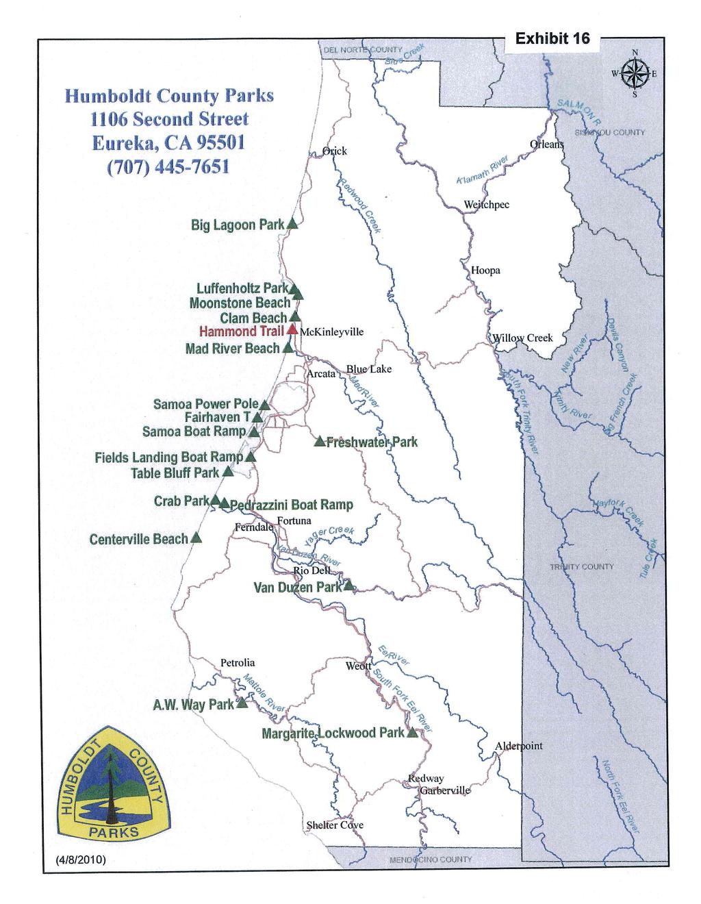
70
Northeast Quadrant Distinctive Features
 NORTHEAST QUADRANT Northeast Quadrant Distinctive Features LAND USE The Northeast Quadrant includes all the area within the planning area that is east of Interstate 5 and to the north of State Route 44.
J. Recreation Plan of Conservation and Development. The Town of Hebron. Section 2. Preservation of Unique Assets. 1 P a g e
 The Town of Hebron Section 2 2014 Plan of Conservation and Development Preservation of Unique Assets J. Recreation Open spaces, parks, sports fields, and recreational programs are considered essential
Chapter eight. Parks and Recreation. Introduction. Crystal Lake Park District
 Chapter eight Parks and Recreation Introduction One of the indicators of quality of life in a city is the parks and recreation system. The City of Crystal Lake is fortunate to have an excellent parks and
2. Goals and Policies. The following are the adopted Parks and Trails Goals for Stillwater Township:
 D. PARKS AND TRAILS 1. Introduction Stillwater Township s population is relatively low, with most residents living on rural residences on large lots. The need for active park space has been minimal in
Appendix C - Existing Developed Parks
 Appendix C - Existing Developed Parks Table of Contents Appendix C Existing Developed Parks Table of Contents... Pg. i Introduction... Pg. ii Amos P. Catlin Park... Pg. 1 Beacon Hill Park... Pg. 1 Cambridge
Park Design and Location Criteria
 Park Design and Location Criteria This section is presented in the interest of assisting park and recreation agencies in the development of a system of parks and recreation areas. A recreation system is
4MRV Parks Master Plan: Site Analysis
 4MRV Parks Master Plan: Site Analysis Lardner/Klein Landscape Architects in association with: RK&K Grimm + Parker Kittelson & Associates Partners for Economic Solutions RIB U.S.Cost Civil Engineering Architecture
The City of Durango Community Interest and Opinion Survey Executive Summary
 The City of Durango Community Interest and Opinion Survey Executive Summary Overview ETC Institute administered a community interest and opinion survey for the City of Durango between January and March
4.0 FACILITIES INVENTORY
 4.0 FACILITIES INVENTORY 4.1 PARK LEVEL OF SERVICE STANDARDS (LOS) Based on current City of Longview Parks and Recreation Level of Service (LOS) Standards (Figure G), the City currently has a deficiency
Blueways: Rivers, lakes, or streams with public access for recreation that includes fishing, nature observation, and opportunities for boating.
 Parks, Open Space and Trails PRINCE WILLIAM COUNTY 2008 COMPREHENSIVE PLAN TRAILS PLAN CONTENTS The components of the trails plan are: Intent Definitions Goals, Policies, and Action Strategies Trails Map
Classifications, Inventory and Level of Service
 Classifications, Inventory and Level of Service Section 3 Kenmore Park, Recreation and Open Space Plan 1 P a g e Classifications and Inventory Park Classifications Kenmore classifies its parks based upon
Frederickson LUAC. Community Plan Update. Parks & Recreation. September 25, 2017
 Frederickson LUAC Community Plan Update Parks & Recreation September 25, 2017 Kimberly Freeman Resource Stewardship Superintendent kimberly.freeman@co.pierce.wa.us 253-798-4261 Joseph Coppo Senior Parks
Silver Lake Park An Environmental Jewel for the Citizens of Prince William County
 Silver Lake Park An Environmental Jewel for the Citizens of Prince William County The Prince William Park Authority Mission Statement states: The Prince William County Park Authority will create quality
NORTHWEST SECTION CONTENTS: CLEVELAND PARK FOLWELL PARK RYAN LAKE PARK VICTORY PRAIRIE DOG PARK VICTORY PARK
 NORTHWEST SECTION CONTENTS: CLEVELAND PARK FOLWELL PARK RYAN LAKE PARK VICTORY PRAIRIE DOG PARK VICTORY PARK LUCY LANEY COMMUNITY SCHOOL N 33RD AVE N 33RD AVE SINGLE-FAMILY RESIDENTIAL MULTI-USE DIAMOND
Trail Etiquette. Hours of Operation. Trail Accessibility
 Trail Guide The Elmhurst Park District, with 28 parks and over 460 acres of land, offers nearly six miles of paved or asphalt park trails and maintains an additional 3.6 miles of trails within Elmhurst.
Dover Park Master Plan. Community Design Event Tuesday, May 22, 5 7 pm
 Dover Park Master Plan Community Design Event Tuesday, May 22, 5 7 pm Agenda I. Introduction / Overview 20 minutes II. Small Group Design Activity 60 minutes III. Small Group Report Out IV. Conclusion
Chapter 2: Summary of Existing Open Space System
 Chapter 2: Summary of Existing Open Space System In 1976, the Wake County Board of Commissioners established the Wake County Parks and Recreation Department in order to provide park facilities and programs
City of Keller Parks and Facilities Inventory
 City of Keller Parks and Facilities Inventory April 2013 1. BEAR CREEK PARK 44 ACRES 1 Basketball Court with 2 goals 4 Drinking Fountains 1 Large Pavilion with 4 picnic tables, electricity and fireplace
Lake Myra County Park. Wake County, North Carolina Community Forum #2 June 12, 2008
 Lake Myra County Park Wake County, North Carolina Community Forum #2 June 12, 2008 Welcome and Introduction Meeting Agenda Welcome Introductions of Project Team Master Plan Process Community Forum #1 Updates
FEASIBILITY CRITERIA
 This chapter describes the methodology and criteria used to evaluate the feasibility of developing trails throughout the study areas. Land availability, habitat sensitivity, roadway crossings and on-street
CHAPTER 4 EXISTING PARKS AND RECREATION FACILITIES INVENTORY
 CHAPTER 4 EXISTING PARKS AND RECREATION FACILITIES INVENTORY Existing park and recreation sites and facilities provide the basis upon which to build a park and recreation plan for the city. This inventory
PIONEER PARK. City of Des Peres Parks Master Plan. SWT Design 46 INTRODUCTION
 PIONEER PARK INTRODUCTION Pioneer Park is a 7 acre neighborhood park located east of Interstate 270 and south of Manchester Road along Tallie Road. The park is situated in a residential neighborhood with
Southwest Quadrant Distinctive Features
 SOUTHWEST QUADRANT Southwest Quadrant Distinctive Features LAND USE The 31.17 square mile Southwest Quadrant includes all the area within the planning area west of I-5 and south of the Sacramento River.
Appendix B - Undeveloped Parks and Existing Parks with Remaining Development Programming
 Appendix B - Undeveloped Parks and Existing Parks with Remaining Development Programming Table of Contents Appendix B - Undeveloped Parks and Existing Parks with Remaining Development Programming Table
NEW MEADOWS PARK PROPOSED MASTER PLAN
 NEW MEADOWS PARK PROPOSED MASTER PLAN A vision for your neighborhood park, the draft master plan is ready for your review. Tuesday September 12 th, 2017 5:30-7:00 PM Hellgate School District #4 middle
CHAPTER 5. Chapter 5 Recreation Element
 CHAPTER 5 Recreation Element Chapter 5 Recreation Element The Recreation Element of the Meyers Area Plan is a supplement to the Recreation Element of the TRPA Regional Plan and the El Dorado County General
MASTER PLAN EXECUTIVE SUMMARY
 Biscuit Run State Park Scottsville Road (State Route 20) Charlottesville, VA 22902 Biscuit Run State Park MASTER PLAN EXECUTIVE SUMMARY Department of Conservation and Recreation Division of Planning and
APPENDIX E: SUMMARY OF PUBLIC MEETING QUESTIONNAIRE RESULTS
 Appendices Gwinnett County 2004 Comprehensive Parks and Recreation Master Plan APPENDIX E: SUMMARY OF PUBLIC MEETING QUESTIONNAIRE RESULTS March 2004 Monteith Brown Planning Consultants & The Jaeger Company
NORTH HEMPSTEAD BEACH PARK MASTER PLAN
 NORTH HEMPSTEAD BEACH PARK MASTER PLAN COMMUNITY DESIGN CHARRETTE Supervisor Judi Bosworth Viviana L. Russell Peter J. Zuckerman Angelo P. Ferrara Anna M. Kaplan Lee R. Seeman Dina M. De Giorgio VISIONING
Wilds. Headwaters. Lakes. Oxbows. Falls
 56 5 4 3 Wilds Headwaters Lakes Oxbows Falls 57 Zones It could be said the on-the-ground essence of this master plan appears within the next 6 pages of this report. As we learned in the preceding Cultural
Chapter 6. Action Program. Heart of the Lakes Area Recreation Plan
 Heart of the Lakes Area Recreation Plan 1. Design and construct the following trails (please see the following map): a. the Speedway Trail 1) primary pathway the main trail 2) secondary pathway the proposed
CITY OF MANVEL Parks & Recreation Master Plan Community Meeting Summary
 CITY OF MANVEL Parks & Recreation Master Plan Community Meeting Summary The City of Manvel hosted a Community Meeting on June 23, 2016 at the Church of the Harvest. Over 25 community members attended and
Blue River Trail Master Plan JSA to Town Hall June 2004
 Blue River Trail Master Plan JSA to Town Hall June 2004 Prepared for: Silverthorne Town Council Silverthorne SPORT Committee Department of Recreation and Culture Silverthorne Public Works Silverthorne
WEST JORDAN PARKS, RECREATION AND TRAILS MASTER PLAN Advisory Committee Meeting #2
 WEST JORDAN PARKS, RECREATION AND TRAILS MASTER PLAN Advisory Committee Meeting #2 MONDAY, NOVEMBER 5, 2018, 6:00 P.M.; PARKS DEPT. CONFERENCE ROOM ATTENDEES: Lisa Dean Larry Gardner Duane Harding David
BRYAN REGIONAL PARK. Presented by: Burditt Consultants November 13, 2018
 BRYAN REGIONAL PARK Presented by: Burditt Consultants November 13, 2018 AGENDA 1. Project Purpose & Mission 2. Project Vision & Goals 3. Stakeholder Feedback 4. Program Overview 5. Phase A Plan Overview
BASSETTS CREEK SECTION CONTENTS: BASSETTS CREEK BRYN MAWR LUCE LINE
 BASSETTS CREEK SECTION CONTENTS: BASSETTS CREEK BRYN MAWR LUCE LINE GLENWOOD AVE MULTI-USE DIAMONDS VINCENT AVE N MORGAN AVE N PENN AVE N DOG PARK MULTI-USE FIELDS PLAYGROUND AK E RD S CHESTNUT AVE DA
Capital Prioritization
 14 Capital Prioritization 279 279 280 Park & Recreation CAPITAL PRIORITIZATION As described in Chapter 8, the recommendations presented in Chapter 9 are prioritized to provide a guide for future capital
Town of Queen Creek Park and Facility Rentals Click on each park or facility for additional information
 Town of Queen Creek Park and Facility Rentals Click on each park or facility for additional information Queen Creek Library Ocotillo Road Hawes Road Desert Mountain Park Ellsworth Loop Road Ellsworth Road
AGENDA MEMORANDUM Community Services Department. CSAB Meeting Date: April 10, 2018
 AGENDA MEMORANDUM Community Services Department CSAB Meeting Date: April 10, 2018 To: Community Services Advisory Board From: Dana A. Souza, Director Date: April 4, 2018 Legislative Quasi-Judicial SUBJECT:
City of Oak Harbor Parks & Descriptions
 City of Oak Harbor Parks & Descriptions North West Section Koetje Park - NE 7 th Avenue (3.5 acres) Neighborhood and Community Park with playgrounds on one tot lot, one soccer/practice field, picnic tables,
Chapter 9 Recreation
 Chapter 9 Chapter 9 1.0 INTRODUCTION The Town of Littleton is within one of New England s most important recreation areas. More than three million people live within 100 miles of the area. Local residents
Parks, Recreation, Trails and Open Space Master Plan Survey Results. October 2018
 Parks, Recreation, Trails and Open Space Master Plan Survey Results October 2018 Conducted by Qualtrics subconsultant 300 completed responses Random attempt to get a balanced response from all four Council
Parks Master Plan. Interim Presentation: Long Range Vision August 3, 2016
 Parks Master Plan Interim Presentation: Long Range Vision August 3, 2016 Presentation Outline 1. Overview, Schedule, Needs Assessment Summary 2. Long Range Vision 3. Next Steps 4. Questions, Discussion
CHAPTER 4 -- THE LAND USE PLAN: DESCRIPTIONS AND POLICIES FOR THIRTEEN PLANNING AREAS
 CHAPTER 4 -- THE LAND USE PLAN: DESCRIPTIONS AND POLICIES FOR THIRTEEN PLANNING AREAS NORTH CENTRAL CAC AREA LITTLE VALLEY ROAD TO JUG HANDLE CREEK PLANNING AREA This planning area includes Cleone, Noyo,
Airport Planning Area
 PLANNING AREA POLICIES l AIRPORT Airport Planning Area LOCATION AND CONTEXT The Airport Planning Area ( Airport area ) is a key part of Boise s economy and transportation network; it features a multi-purpose
NAVAJO COMMUNITY PLAN
 NAVAJO COMMUNITY PLAN Prepared by the NAVAJO COMMUNITY PLANNERS and THE CITY OF SAN DIEGO City of San Diego Planning Department 202 C Street, MS 4A San Diego, CA 92101 Printed on recycled paper. This information,
TRUCKEE TAHOE AIRPORT DISTRICT BOARD OF DIRECTOR STAFF REPORT
 AGENDA ITEM: 11 TRUCKEE TAHOE AIRPORT DISTRICT BOARD OF DIRECTOR STAFF REPORT AGENDA TITLE: MEETING DATE: January 24, 2018 PREPARED BY: NTPUD Agency Partnership Opportunity, Multi-Use Trailhead Access
4.19 Parks, Recreation, and Conservation Lands
 interchange would have on the Reed Paige Clark Homestead located on the north side of Stonehenge Road. Alternative D would also affect Palmer Homestead, E.F. Adams House, and Knapp Brothers Shoe Manufacturing
Recreation and Resource Inventories
 Heart of the Lakes Area Recreation Plan Recreation Inventory The recreation inventory for the Heart of the Lakes is comprised of all of the parks and recreation facilities and programs provided in the
Table B-1: P&RS Park and Facility Inventory by Classification 1 Outdoor Recreation Amenities Park Structures
 Appendix B: Park and Facility inventory APPENDIX B: PARK AND FACILITY INVENTORY Table B-1: P&RS Park and Facility Inventory by Classification 1 Outdoor Recreation Amenities Site Amenities Park Structures
Picture your next event in Novi!
 Picture your next event in Novi! Facility Reservation Guide Why Novi? Thank you for considering Novi as the location for your next event. We look forward to welcoming you at one of our unique venues which
Rating: 5.0 (scale of 1-10)
") 95 Community Trail System Groundcover: 2-metre paved path, 1- metre grass buffer on either side. Location: Fort St. John Ownership: City of Fort St. John Rating: 5.0 (scale of 1-10) Strategic value: Linear
95 Community Trail System Groundcover: 2-metre paved path, 1- metre grass buffer on either side. Location: Fort St. John Ownership: City of Fort St. John Rating: 5.0 (scale of 1-10) Strategic value: Linear
Welcome to the future of Terwillegar Park a Unique Natural Park
 Welcome to the future of Terwillegar Park a Unique Natural Park 1 Introduction The Terwillegar Park Concept Plan study will develop an overall concept plan, management objectives and development guidelines
COASTAL CONSERVANCY. Staff Recommendation December 2, 2004 COYOTE HELLYER COUNTY PARK BAY AREA RIDGE TRAIL
 COASTAL CONSERVANCY Staff Recommendation December 2, 2004 COYOTE HELLYER COUNTY PARK BAY AREA RIDGE TRAIL File No. 04-057 Project Manager: Amy Hutzel RECOMMENDED ACTION: Authorization to disburse up to
20 Grant s Trail. Planning Zone 3. Visit Date: September St. Louis County Parks Master Plan
 20 Grant s Trail Planning Zone 3 Visit Date: September 2016 Page 1 20 Grant s Trail Planning Zone 3 Visit Date: September 2016 Page 2 20 Grant s Trail Planning Zone 3 Visit Date: September 2016 Page 3
Contra Costa County Parks and Recreation Facilities
 Contra Costa County Parks and Recreation Facilities CONTRA COSTA COUNTY PUBLIC WORKS DEPARTMENT 255 GLACIER DRIVE MARTINEZ, CALIFORNIA 94553 Parks and Recreation Facilities 1 West County Lefty Gomez Community
M E S T I Z O C U R T I S P A R K
 ARAPAHOE CONNECTION TO BUS ROUTE AT ND AND LAWRENCE, FUTURE LIGHT RAIL STATION LEGEND SOCIAL TRAIL FLAGSTONE PAVING TO RESTORE/MAINTAIN CONCRETE PAVING DIAGONAL CURVILINEAR SOCIAL ROUTE IS OUT OF HISTORIC
Proposal to Redevelop Lower Kananaskis River-Barrier Lake. Bow Valley Provincial Park
 Frequently Asked Questions Proposal to Redevelop Lower Kananaskis River-Barrier Lake Bow Valley Provincial Park Frequently Asked Questions What has been decided? What are the details of the plan? What
APPENDIX OFFICIAL MAP ORDINANCE OF HAMILTONBAN TOWNSHIP OFFICIAL MAP NARRATIVE
 APPENDIX A OFFICIAL MAP ORDINANCE OF HAMILTONBAN TOWNSHIP OFFICIAL MAP NARRATIVE INTRODUCTION: The Official Map of Hamiltonban Township has been prepared to identify those lands and features that Hamiltonban
Webber Park Master Plan Charrette Summary
 SMALL GROUP #1 - September 29, 2011 Webber Park Master Plan Charrette Summary More trash cans, especially near picnic grounds A year round pool is very needed-physical & mental health are significantly
CITY OF FOUNTAIN INN PARKS
 CITY OF FOUNTAIN INN PARKS Country Chase Fitness Park The Country Chase Fitness Park is located in the Country Chase neighborhood at 136 Catterick Way. The park is also located adjacent to a section of
Section 5.16 Parks and Recreation Facilities
 Section 5.16 Parks and Recreation Facilities SECTION 5.16 PARKS AND RECREATION FACILITIES This section identifies existing parks and recreational facilities within the City of Buena Park and provides an
COMMUNITY LOS PRIORITIES
 Part 5. Community Priority Meetings Purpose: The purpose of holding Community Priority Meetings was two-part; (1) to gather input from community members and decision makers on specific park and trail infrastructure
10/25/2013. What is the SCORP?! 2013 Local Government Survey 2013 Statewide Public Survey Advisory Group Priority Areas Your Suggestions!
 COLORADO OUTDOOR RECREATION TRENDS RESULTS FROM THE SCORP AND STATEWIDE Colorado Outdoor Recreation Resource Partnership September 2013 PRESENTATION What is the SCORP?! 2013 Local Government Survey 2013
10 PARKS AND RECREATION ELEMENT
 10 Public parks and recreational facilities are important contributions to quality of life in Chino. Parks are prime locations for physical activity, sports, relaxation and community gatherings, which
National Forests and Grasslands in Texas
 United States Department of Agriculture Forest Service National Forests and Grasslands in Texas Sam Houston NF 394 FM 1375 West New Waverly, Texas 77358 Phone 936-344-6205 Dear Friends, File Code: 1950
Proposal to Redevelop Lower Kananaskis River-Barrier Lake. Bow Valley Provincial Park. Frequently Asked Questions
 Proposal to Redevelop Lower Kananaskis River-Barrier Lake Bow Valley Provincial Park Frequently Asked Questions What is being proposed? What are the details of the proposal? Where is the project area located?
SOAR ATHLETIC COMMITTEE
 PASCAGOULA RECREATION COMMISSION MEETING MAY 15, 2017 Mike McElhaney opened the meeting at 6:00 pm. Mike welcomed Bo Cole as a guest. A special meeting was called to review the recommendation being made
CRANE LAKE TRAILS NETWORK AND SPACES
 CRANE LAKE TRAILS NETWORK AND SPACES AREA TRAILS COMMUNITY TRAILS GOLD COAST TRAIL LAKE PARK OPTION ONE LAKE PARK OPTION TWO OVERFLOW TRAILHEAD PARKING THE GATE AREA TRAILS Trails are a major resource
Villages at Buffalo Run East
 Villages at Buffalo Run East Neighborhood Park Subhead to title page goes here. Public Design Meeting April 9, 2015 Capital Improvement Program Commerce City s $137 million CIP is the result of a 2013
Business Item No
 Metropolitan Parks and Open Space Commission Meeting date: February 6, 2018 For the Community Development Committee meeting of February 20, 2018 For the Metropolitan Council meeting of February 28, 2018
NORTH OF BROADWAY SECTION CONTENTS: COTTAGE PARK FARVIEW PARK GLEN GALE PARK IRVING TRIANGLE JORDAN PARK NEWTON PARK PERKINS HILL PARK
 NORTH OF BROADWAY SECTION CONTENTS: COTTAGE PARK FARVIEW PARK GLEN GALE PARK IRVING TRIANGLE JORDAN PARK NEWTON PARK PERKINS HILL PARK N ILIO NA VE N JAM ES AV E PLAYGROUND PAR K PRO PER TY B OUN DAR Y
Longmont to Boulder Regional Trail Jay Road Connection DRAFT FINAL REPORT
 Longmont to Boulder Regional Trail Jay Road Connection DRAFT FINAL REPORT December 2018 Project Summary Boulder County, Colorado, in partnership with the City of Boulder, is evaluating options for multi-use
Brentsville Courthouse
 46 Prince William County Proposed FY 2014-2019 Capital Improvement Program Brentsville Courthouse Existing budget will complete the jail restoration. There is no additional funding allocated to projects
Municipal Park Descriptions: 1. Bear Hollow Park 4100 Bear Hollow Park Court, Murrysville, PA acres
 MUNICIPAL PARK DESCRIPTIONS Murrysville has a wide variety of parks and recreational facilities including sports fields, neighborhood parks, community parks, a Community Center, and extensive natural areas
Tahoe Donner Association Public Scoping Meeting DUDEK
 Tahoe Donner Association Public Scoping Meeting DUDEK Introduction Purpose of this Meeting: Solicit feedback and ideas from members, and staff as we begin the Association Master Plan. Association Master
DEPARTMENT OF PARKS & RECREATION
 DEPARTMENT OF PARKS & RECREATION 2016 Budget Presentation 1 RONALD ZUBER, DIRECTOR March 7, 2016 2015 ACCOMPLISHMENTS OFFICE OF DIRECTOR Hosted the National Junior Disability Championships from July 16
Binley Woods Parish Plan - Analysis of Main Survey Responses Section D1 Sports Activities & Play Equipment
 Binley Woods Parish Plan - Analysis of Main Survey Responses Section D1 Sports Activities & Play Equipment Question D1: How often do you use the following? Binley Woods Parish Plan Main Questionnaire 1
FINAL TESTIMONY 1 COMMITTEE ON RESOURCES UNITED STATES HOUSE OF REPRESENTATIVES. July 13, 2005 CONCERNING. Motorized Recreational Use of Federal Lands
 FINAL TESTIMONY 1 STATEMENT OF DALE BOSWORTH CHIEF Of the FOREST SERVICE UNITED STATES DEPARTMENT OF AGRICULTURE Before the SUBCOMMITTEE ON FORESTS AND FOREST HEALTH And the SUBCOMMITTEE ON NATIONAL PARKS,
City of Haslett. City of East Lansing. City of East Lansing
 Central Park North (Nancy L. Moore Park) Lake Park North Expansion White Park Expansion #2 White Park Expansion #1 County East East Haslett East East TF87-212 Acquisition $90,000.00 Park. TF08-138 Acquisition
GUIDE TO FACILITY RENTAL. Canada Games Centre Takhini Arena Mount McIntyre Shipyards Park
 GUIDE TO FACILITY RENTAL Canada Games Centre Takhini Arena Mount McIntyre Shipyards Park OUR FACILITIES TA Canada Games Centre The Canada Games Centre () is a multi-use community sport, recreation, and
7. Plan Implementation
 7. Plan Implementation 7.1 Implementation Timeline This section includes a list of achievable park and recreation actions. In the Implementation Action Matrix that follows, the implementation actions have
PARKS AND RECREATION ELEMENT
 PARKS AND RECREATION ELEMENT Prepared by: Planning & Development Services Department County of Imperial 801 Main Street El Centro, California 92243 Jurg Heuberger, AICP Planning Director Approved by: Board
Flow Stand Up Paddle Board Parkway Plan Analysis
 Regional Parks Department Jeffrey R. Leatherman, Director County of Sacramento Divisions Administration Golf Leisure Services Maintenance Rangers Therapeutic Recreation Services Flow Stand Up Paddle Board
EXECUTIVE SUMMARY PROGRAM DEVELOPMENT REPORT PURPOSE EXISTING SETTING EXPANDING PARKLAND
 EXECUTIVE SUMMARY PROGRAM DEVELOPMENT REPORT PURPOSE As the culmination of the first phase of the master planning process, this Program Development Report creates the framework to develop the Calero County
AGENDA ITEM 5 D WAKULLA ENVIRONMENTAL INSTITUTE (WEI) TRAIL FEASIBILITY STUDY
 TRAIL FEASIBILITY STUDY") March 19, 2018 AGENDA ITEM 5 D WAKULLA ENVIRONMENTAL INSTITUTE (WEI) TRAIL FEASIBILITY STUDY TYPE OF ITEM: Action STATEMENT OF ISSUE The Wakulla Environmental Institute (WEI) Trail is one of several trails
March 19, 2018 AGENDA ITEM 5 D WAKULLA ENVIRONMENTAL INSTITUTE (WEI) TRAIL FEASIBILITY STUDY TYPE OF ITEM: Action STATEMENT OF ISSUE The Wakulla Environmental Institute (WEI) Trail is one of several trails
PARKING CAPACITY REQUIREMENTS
 PARKING CAPACITY REQUIREMENTS Presented to: Antaramian Development Corporation 365 5 th Avenue South Naples, Florida 34102 CONTENTS Page INTRODUCTION... 1 BACKGROUND... 2 EXISTING PARKING CONDITIONS...
New Haven-Adams Twp Parks & Recreation Dept Citizen Survey
 New Haven-Adams Twp Parks & Recreation Dept Citizen Survey Monday, October 02, 2017 281 Total Responses Date Created: Thursday, July 13, 2017 Complete Responses: 243 Q1: Do you live in New Haven-Adams
Sibley LUPA. Board Executive Committee Meeting December 7, 2017
 Sibley LUPA Board Executive Committee Meeting December 7, 2017 Project Location & Project Area 1,318-acre Robert Sibley Volcanic Regional Preserve Project Area Purpose Project Purpose & Goals Append the
Sevierville, TN. Technical Appendices
 Sevierville, TN Technical Appendices 2017 2955 Valmont Road Suite 300 777 North Capitol Street NE Suite 500 Boulder, Colorado 80301 Washington, DC 20002 n-r-c.com 303-444-7863 icma.org 800-745-8780 Contents
BACK COUNTRY UNIT PREFERRED ALTERNATIVE
 BACK COUNTRY UNIT PREFERRED ALTERNATIVE San Francisco (118 mi) Carmel-By-The-Sea Carmel River Carmel Valley Road State Beach Private Property Point Lobos State Reserve Point Lobos Ranch RUSTIC CAMPING
6.5 DURANGO EXCELS AT PARK CONNECTIVITY
 City of Durango 6.5 DURANGO EXCELS AT PARK CONNECTIVITY The City of Durango excels at park connectivity as evidenced by the success of the Animas River Trail (ART) project. While it is clear there are
CHAPTER 4 -- THE LAND USE PLAN: DESCRIPTIONS AND POLICIES FOR THIRTEEN PLANNING AREAS
 CHAPTER 4 -- THE LAND USE PLAN: DESCRIPTIONS AND POLICIES FOR THIRTEEN PLANNING AREAS SOUTH COAST CAC PLANNING AREA 4.10 NAVARRO RIVER TO MALLO PASS CREEK PLANNING AREA (Includes Greenwood/Elk) This planning
Lake Sammamish Public Meeting Comments Tibbits Creek Manor, March 29, 2018
 Lake Sammamish Public Meeting Comments Tibbits Creek Manor, March 29, 2018 Washington State Parks Mission The Washington State Parks and Recreation Commission cares for Washington s most treasured lands,
Nelson/Tasman Recreation Cross Boundary Partnerships. Presented by Richard Kempthorne Mayor Tasman District
 Nelson/Tasman Recreation Cross Boundary Partnerships Presented by Richard Kempthorne Mayor Tasman District Presentation in two parts Regional Communities Facilities Plan Regional Communities Facilities
CARMEL VALLEY PARK & RECREATION COUNCIL San Diego Park & Recreation Department Carmel Valley Rec. tlon Council
 CARMEL VALLEY PARK & RECREATION COUNCIL San Diego Park & Recreation Department Carmel Valley Rec. tlon Council October 1,2000 Park Improvements Listing: M-I Carmel Valley Area Map M-2 Carmel Valley Community
Santa Clara South Hills Recreation Park Project Development and Management Plan
 Santa Clara South Hills Recreation Park Project Application for Land for Recreation or Public Purposes, City of Santa Clara, Utah Prepared for: Bureau of Land Management, St. George Field Office 345 East
City of Durango 5.8 FUNDING TRAILS DEVELOPMENT
 5.8 FUNDING TRAILS DEVELOPMENT The City has been successful in establishing dedicated local funding sources as well as applying for grants to develop the City s trail system, having received nearly $2.4
HOST YOUR NEXT EVENT IN FIFE
 HOST YOUR NEXT EVENT IN FIFE Venue Rental Guide Host Your Next Event In Fife Weddings. Corporate Events. Parties. Sporting Events. Convenient and Flexible Spaces for Your Event From board meetings to weddings,
PALO CORONA REGIONAL PARK MPRPD BOARD MEETING AUGUST 8, 2018
 PALO CORONA REGIONAL PARK MPRPD BOARD MEETING AUGUST 8, 2018 ACKNOWLEDGEMENTS AGENCIES AND ORGANIZATIONS The Trust for Public Land Big Sur Land Trust Santa Lucia Conservancy California State Parks Point