PALO CORONA REGIONAL PARK MPRPD BOARD MEETING AUGUST 8, 2018
|
|
|
- Sharleen Watson
- 5 years ago
- Views:
Transcription


1 PALO CORONA REGIONAL PARK MPRPD BOARD MEETING AUGUST 8, 2018
2 ACKNOWLEDGEMENTS AGENCIES AND ORGANIZATIONS The Trust for Public Land Big Sur Land Trust Santa Lucia Conservancy California State Parks Point Lobos Foundation California Fish & Wildlife Wildlife Conservation Board Coastal Conservancy Ventana Wildlife Society Trout Unlimited Monterey County Local Municipalities, Representatives, and HOAs Monterey Peninsula Water Management District California Natural Resources Agency PRIVATE LAND OWNERS Hatton Family Diana Fish Tony Lombardo Alan Williams Eastwood Family PUBLIC, STAKEHOLDERS, AND NEIGHBORS

3 AGENDA Introduction Summary of Public Outreach Efforts Review of Preferred Alternative General Development Plan Document Structure Next Steps
4 PROJECT TIMELINE SITE VISIT & FOCUS GROUP MEETINGS PUBLIC OPEN HOUSE DRAF T GDP DOCUMENT SUMMARY OF PREVIOUS WORK PROJECT WEBSITE L AUNCH PUBLIC WORKSHOP 1 - OCT 5, NOV 1 & 2, 2017 EXISTING CONDITIONS AND RE-USE REPORT SITE ALTERNATIVE DEVELOPMENT PUBLIC WORKSHOP 2 - NOV 15 & 16, 2017 PREFERRED ALTERNATIVE DEVELOPMENT PUBLIC WORKSHOP 3 - FEB 7 & 8, 2018 PREFERRED ALTERNATIVE REFINEMENT MPRPD BOARD PRESENTATION - APRIL 11 DRAF T MASTER PL AN DEVELOPMENT MPRPD BOARD PRESENTATION - AUGUST 8 ADOPTION OF DRAFT GDP CEQA SPRING 2017 SUMMER FALL WINTER WINTER SPRING SUMMER 2018 WE ARE HERE PROJECT START-UP PROGRAMMING & ALTERNATIVES PCRP MASTER PLAN
5 PROJECT PURPOSE & OBJECTIVES RESTORATION Improve water quality and aquatic habitat of the Carmel River Minimize wildlife fragmentation Restore areas to natural habitat Reintroduce common, threatened and endangered flora and fauna RECREATION Community and user group access Diverse trail network for varied abilities and experiences Trail Connectivity Inclusive park-appropriate programs, facilities, and activities RE-USE Re-use or retrofit of existing facilities and infrastructure Re-use and improvement of former golf course to create more natural habitat Continued community use for meetings and gatherings Collaboration with community and agency partners

6 PROJECT AREA 185
7 PUBLIC OUTREACH PROCESS Focus Group Meetings Public Open House Information Gathering Public Workshop #1 SURVEY #1 Public Workshop #2 SURVEY #2 Public Workshop #3 Review Alternative Concepts Review Preferred Alternative Obtain Suggestions & Ideas GENERAL SPECIFIC SURVEY #3 Presentation to Board Revise Preferred Alternative Develop General Development Plan Plan Presentation to the Board


8 PROJECT WEBSITE Project website: palocorona.org View project and timeline updates Keep informed about upcoming meetings View materials and project documents Take online surveys Sign up for mailing list
9 PUBLIC OUTREACH SUMMARY CONCERNS Don t want parking to be used for Point Lobos access Traffic impact on Hwy 1 and Carmel Valley Road Overuse and crowding Adequate Funding to maintain what is improved Over-Use, especially by non-regional visitors OPPORTUNITIES Hiking and trail opportunities within Palo Corona Regional Park Fenced in Dog Park for all, especially elderly and mobility impaired. ADA/Inclusive access, facilities and programs for populations that cannot access park s rugged terrain or other parks in the region Gathering space for club meetings and events Discovery Center and Interpretive Education

10 PALO CORONA REGIONAL PARK PREFERRED ALTERNATIVE

11 PREFERRED ALTERNATIVE - BACK COUNTRY UNIT Backcountry access by permit Hiking and trail opportunities within Palo Corona Regional Park Opportunities for trail connectivity to adjacent parks and open space Limited, permit-only camping sites On-site ranger staff to patrol park full-time Mountain bike, equestrian, and multi-use trails Research and educational/ interpretive opportunities Emergency access and potential to expand cell phone coverage Point Lobos State Reserve LEGEND Existing Trails Programming Opportunities Potential Trail Connections Potential Emergency Access Routes PCRP Park Boundary Adjacent Open Space Boundaries Highway 1 Carmel-By-The-Sea Point Lobos Ranch Carmel River State Beach Corona Road Carmel Highlands Garrapata State Park Point Lobos Ranch VISTA POINT Carmel Valley Road DAY-USE IMPROVEMENTS TO BARN WITH PICNIC AREA AND YOUTH EDUCATIONAL CAMPING RUSTIC CAMPING AT WHISLER WILSON WITH RANGER STATION Santa Lucia Preserve DAY-USE OR RUSTIC CAMPING AT CORONA HOMESTEAD Mitteldorf Preserve WILDLIFE VIEWING AREA Joshua Creek Ecological Reserve Carmel Valley Rancho San Carlos Road Figure 9: Opportunities and Constraints diagram of PCRP. GIS data provided by Turf Image Geospatial Consulting.

12 PREFERRED ALTERNATIVE - FRONT RANCH UNIT Multi-use trail access to Back Country Unit with speed control measures for safety Potential multi-use trail connection to Carmel River State Beach Repurpose barn for interpretive, educational, and special events uses Exploring options for potential sites for horse trailer staging area to access Back Country Unit Continued special permits for community and non-profit events/fundraisers Closing vehicular parking on Hwy 1 (parking lot for special use only) Pedestrian access from neighborhoods to continue


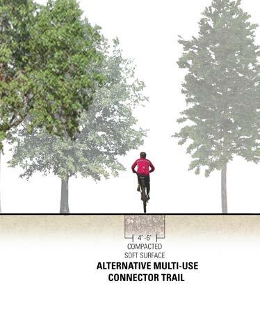
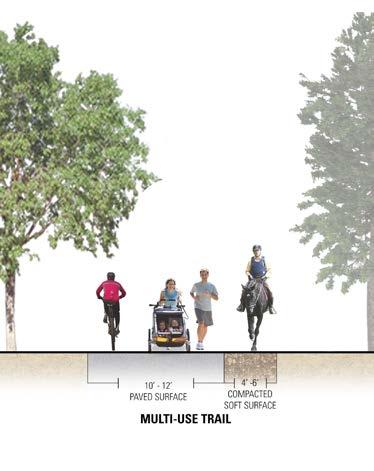
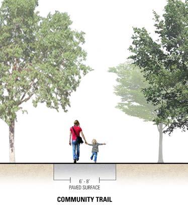
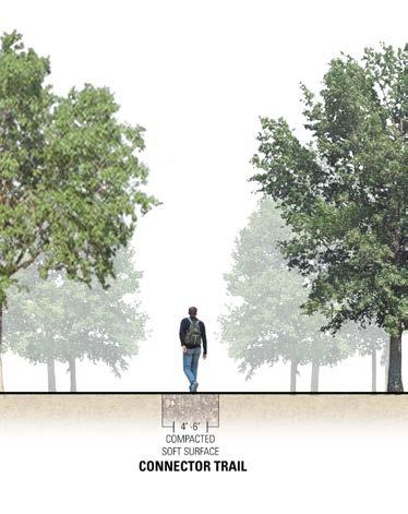
13 TYPES OF TRAIL PROPOSED FOR PALO CORONA ALTERNATIVE MULTI-USE SINGLE TRACK PAVED COMMUNITY TRAIL PAVED MULTI-USE & SOFT-SURFACE SHOULDER MULTI-USE SINGLE TRACK TRAIL
 Pedestrian Access and Vehicular Access by Special Permit Only Adaptive Re-Use of Historic Barn *Additional Trail Connection(s) to be determined by State Parks Future Carmel River FREE")
14 FRONT RANCH UNIT - PALO CORONA REGIONAL PARK LEGEND Connection to Carmel River State Beach* WEST ENTRANCE Multi-Use Trail (RC Unit - Paved) Multi-Use Trail (Unpaved) Alternative Multi-Use Route (Unpaved) Pedestrian Access and Vehicular Access by Special Permit Only Adaptive Re-Use of Historic Barn *Additional Trail Connection(s) to be determined by State Parks Future Carmel River FREE Trails Community Trails (Unpaved) Connector Trails (Unpaved) Future Carmel River FREE Trails (Unpaved) Potential Multi-Use Trail (Unpaved) Picnic * CARMEL RIVER Carmel River FREE Project Area Picnic Area Vegetated Screening Parking by Special Permit Only Community Trail Carmel River FREE Project Dispersed Picnic Interpretive Element PCRP Park Boundary Future Carmel River FREE Trails Potential Multi-Use Trail Connector Tr. Picnic Picnic Note: Future Back Country access beyond Animas Pond by permit only RANCHO CAÑADA VILLAGE Note: Dogs not allowed south of South Bank Trail Alternative Multi-use route Multi-use access to Back Cty Inspiration Point * Multi-use access to Back Country Multi-use Trail FRONT RANCH ENTRANCE

15 PREFERRED ALTERNATIVE - RANCHO CAÑADA UNIT Priority Restoration Zone CARMEL MIDDLE SCHOOL MEarth CARMEL VALLEY ROAD COMMUNITY CHURCH OF THE MONTEREY PENINSULA RE-USE ZONE SLC Future Restoration Zone Transition Zone TRANSITION ZONE Re-Use Zone RANCHO CAÑADA VILLAGE FUTURE RESTORATION ZONE Emergency event command center/ Staging Area 1000 Wildlife Corridor FRONT RANCH ENTRANCE PRIORITY RESTORATION ZONE SOUTH BANK TRAIL Note: Dogs allowed in Rancho Canada Unit, on leash Dogs not allowed south of South Bank Trail Parking at Rancho San Carlos entrance requires permit PCRP Park Boundary Non-exclusive environmental education and conservation easement
 Alternative Multi-Use Route (Unpaved) Community Trails (Paved) RANCHO CAÑADA VILLAGE POTENTIAL CONNECTION TO BEACH/RIVER Alt.")
16 PREFERRED ALTERNATIVE - RANCHO CAÑADA UNIT Multi-Use Trails (Paved) CARMEL MIDDLE SCHOOL MEarth CARMEL VALLEY ROAD COMMUNITY CHURCH OF THE MONTEREY PENINSULA Martin Canyon SLC Potential Multi-Use Trail Connection (Unpaved) Alternative Multi-Use Route (Unpaved) Community Trails (Paved) RANCHO CAÑADA VILLAGE POTENTIAL CONNECTION TO BEACH/RIVER Alt. Multi-use route Multi-Use Trail Multi-Use Trail FRONT RANCH ENTRANCE Note: Dogs not allowed south of South Bank Trail Community Trail SOUTH BANK TRAIL Co nector Trail Multi-Use Trail Connector Trails (Unpaved) Emergency event command center/ Staging Area 1000 Wildlife Corridor PCRP Park Boundary Non-exclusive environmental education and conservation easement

17 PREFERRED ALTERNATIVE - RANCHO CAÑADA UNIT LEGEND Multi-Use Trail Community Trail Connector Trail Emergency Event Staging Area 1000 Wildlife Corridor PCRP Park Boundary Easements CARMEL MIDDLE SCHOOL Potential Dog Park Area RANCHO CAÑADA VILLAGE MEarth CARMEL VALLEY ROAD COMMUNITY CHURCH OF THE MONTEREY PENINSULA Dispersed Picnic Area Picnic Pavilions Inclusive/Exploratory Play Area Amphitheater Trailhead Multi-Use Trail Restroom Building/Plaza Multi-Use Trail Trailhead Connector Trail Potential Future Trail Connection to Martin Canyon SLC Outdoor Classroom Pavilion Connector Trail Community Trail Multi-Use Trail Multi-Use Trail Community Trail Multi-Use Trail to access Back Country POTENTIAL CONNECTION TO BEACH Alternative Multi-Use Connector Trail Front Ranch Entrance SOUTH BANK TRAIL Dispersed Picnic Area River Overlook Outdoor Classroom Pavilion

18 PREFERRED ALTERNATIVE - RANCHO CAÑADA UNIT Picnic Lawn Area Picnic Gravel Parking Area Trailhead Picnic Restroom Building/Plaza Observation Dock Shop Picnic Pavilion Picnic Pavilion Trailhead Inclusive/ Exploratory Play Amphitheater Information Kiosks Discovery Center LEGEND Multi-Use Trail Community Trail Connector Trail Emergency Event Staging Area


19 PLAN ELEMENTS - CLUBHOUSE CLUBHOUSE USES Discovery Center 1 Gathering space for club meetings, and public and private events 2 Office and administrative space 3 4 Basement/lower level may become tenant space Community Meetings & Events


20 PLAN ELEMENTS - POND & COMMUNITY LAWN 1 PICNIC PAVILION 2 OBSERVATION DOCK INCLUSIVE AND EXPLORATORY PLAY 5 RESTROOM/PLAZA AMPHITHEATER


21 PLAN ELEMENTS - TRAILHEAD 1 TRAILHEAD & KIOSKS PICNIC PAVILION
 Ecology of park, highlight different habitats and ecological")
 Lessons learned from introducing non-native species (wild boar) 1 2 RIVER")
22 PLAN ELEMENTS - RIVER OVERLOOK & OUTDOOR CLASSROOM Ranch heritage history/working cattle lands Wildlife of park (enhanced habitat resulting in reintroduction of redlegged frog, condors, steelhead trout and other species) Ecology of park, highlight different habitats and ecological diversity Natural history of region Cultural history (Native Americans, literary figures, bear/ bull fights, Fish Ranch and land purchase) Watershed/Hydrology (Carmel River Restoration, Land-to-Sea connection) Lessons learned from introducing non-native species (wild boar) 1 2 RIVER OVERLOOK OUTDOOR CLASSROOM


23 PLAN ELEMENTS - CAL FIRE EMERGENCY STAGING AREA & WILDLIFE CORRIDOR WITH PASSIVE RECREATION 1 WILDLIFE CORRIDOR EMERGENCY EVENT COMMAND CENTER/ STAGING AREA CalFire, county and others use of site during emergencies Adaptive use as a dog park when not in use for emergencies Will repair/restore park after use Area to be used for passive recreation during normal park operation PASSIVE RECREATION


24 FUTURE OPPORTUNITIES Other potential activities or programming that could be introduced to the park in the future with partnerships or increased interest Flexible plan that will continue to meet the needs of the community as the community and the park evolve: Native plant nursery Art in the park Fitness course Additional opportunities Scientific research (phenology, climate change, post-fire ground cover recovery and species modification, etc.)
 Vista Lobos Trail (Existing) 1000 Wildlife Corridor PCRP Park Boundary Non-exclusive environmental education and conservation easement To be opened for public use at a")
25 INTERIM TRAILS PLAN - RANCHO CAÑADA UNIT CARMEL MIDDLE SCHOOL MEarth RANCHO CAÑADA VILLAGE CARMEL VALLEY ROAD COMMUNITY CHURCH OF THE MONTEREY PENINSULA Mowed Path SLC Interim Trails Open to the Public (Existing Cart Paths) Vista Lobos Trail (Existing) 1000 Wildlife Corridor PCRP Park Boundary Non-exclusive environmental education and conservation easement To be opened for public use at a later phase Vista Lobos Trail FRONT RANCH ENTRANCE SOUTH BANK TRAIL
26 DRAFT OUTLINE EXECUTIVE SUMMARY V INTRODUCTION 1 MONTEREY PENINSULA REGIONAL PARK DISTRICT 3 PALO CORONA RANCH AND RANCHO CAÑADA ACQUISITION 3 GENERAL DEVELOPMENT PLAN 5 SITE CONTEXT 5 PREFERRED ALTERNATIVE 59 ACQUISITION AND LAND TRANSFER 60 TRAILS AND PUBLIC ACCESS PLAN 62 RECREATIONAL USES 72 SUPPORT FACILITIES AND SPECIAL USES 92 NATURAL RESOURCE AND CONSERVATION PLAN 98 INTERPRETIVE AND EDUCATIONAL PLAN 100 SITE ASSESSMENT 7 SUMMARY OF EXISTING STUDIES 8 OFF-SITE ASSESSMENT 16 ON-SITE ASSESSMENT 20 OPPORTUNITIES AND CONSTRAINTS 35 PUBLIC OUTREACH 35 INITIAL FOCUS GROUP MEETINGS 36 OPEN HOUSE AND PUBLIC FORUM 42 ADDITIONAL FOCUS GROUP MEETINGS 46 PUBLIC WORKSHOP SUMMARIES 50 MPRPD PUBLIC BOARD MEETINGS 56 NEXT STEPS 105 INTERIM USE AND PHASING 106 FUNDING AND PARTNERSHIPS 109 CALFIRE EMERGENCY STAGING AREA 110 EMERGENCY ACCESS TO BACK COUNTRY UNIT 110 CONTINUED PLAN DEVELOPMENT 112 APPENDIX PARK HISTORY AND ACQUISITION PUBLIC OUTREACH SUMMARY DESIGN ALTERNATIVES REFERENCES

27 NEXT STEPS Board Comments and Adoption of General Development Plan Plan Revisions based on Board comments California Environmental Quality Act (CEQA) assessment Partnerships for obtaining funding and grants for restoration Interpretive and Education Plan Operations and Maintenance Plan Emergency Event Command Center/Staging Area Agreement Habitat Restoration Plan development and subsequent implementation
28 THANK YOU
BACK COUNTRY UNIT PREFERRED ALTERNATIVE
 BACK COUNTRY UNIT PREFERRED ALTERNATIVE San Francisco (118 mi) Carmel-By-The-Sea Carmel River Carmel Valley Road State Beach Private Property Point Lobos State Reserve Point Lobos Ranch RUSTIC CAMPING
EXECUTIVE SUMMARY PROGRAM DEVELOPMENT REPORT PURPOSE EXISTING SETTING EXPANDING PARKLAND
 EXECUTIVE SUMMARY PROGRAM DEVELOPMENT REPORT PURPOSE As the culmination of the first phase of the master planning process, this Program Development Report creates the framework to develop the Calero County
Lake Myra County Park. Wake County, North Carolina Community Forum #2 June 12, 2008
 Lake Myra County Park Wake County, North Carolina Community Forum #2 June 12, 2008 Welcome and Introduction Meeting Agenda Welcome Introductions of Project Team Master Plan Process Community Forum #1 Updates
Sibley LUPA. Board Executive Committee Meeting December 7, 2017
 Sibley LUPA Board Executive Committee Meeting December 7, 2017 Project Location & Project Area 1,318-acre Robert Sibley Volcanic Regional Preserve Project Area Purpose Project Purpose & Goals Append the
FEASIBILITY CRITERIA
 This chapter describes the methodology and criteria used to evaluate the feasibility of developing trails throughout the study areas. Land availability, habitat sensitivity, roadway crossings and on-street
Department of Environment, Climate Change & Water NSW. Stakeholder feedback
 Department of Environment, Climate Change & Water NSW Stakeholder feedback 1 Stakeholders group Blue Gum High Forest Group Guardians of Lane Cove NP Sydney Metropolitan Wildlife Service Ku-ring-gai Historical
Wilds. Headwaters. Lakes. Oxbows. Falls
 56 5 4 3 Wilds Headwaters Lakes Oxbows Falls 57 Zones It could be said the on-the-ground essence of this master plan appears within the next 6 pages of this report. As we learned in the preceding Cultural
CHAPTER 5. Chapter 5 Recreation Element
 CHAPTER 5 Recreation Element Chapter 5 Recreation Element The Recreation Element of the Meyers Area Plan is a supplement to the Recreation Element of the TRPA Regional Plan and the El Dorado County General
City of Durango 5.8 FUNDING TRAILS DEVELOPMENT
 5.8 FUNDING TRAILS DEVELOPMENT The City has been successful in establishing dedicated local funding sources as well as applying for grants to develop the City s trail system, having received nearly $2.4
NEW MEADOWS PARK PROPOSED MASTER PLAN
 NEW MEADOWS PARK PROPOSED MASTER PLAN A vision for your neighborhood park, the draft master plan is ready for your review. Tuesday September 12 th, 2017 5:30-7:00 PM Hellgate School District #4 middle
STORY MILL COMMUNITY PARK
 OWNER: City of Bozeman Department or Parks and Recreation P.O. Box 1230, 415 N. Bozeman Street Bozeman, MT 59715 Tel: (406)-582-2908 APPLICANT: The Trust for Public Land 1007 E. Main Street, Suite 300
2. Goals and Policies. The following are the adopted Parks and Trails Goals for Stillwater Township:
 D. PARKS AND TRAILS 1. Introduction Stillwater Township s population is relatively low, with most residents living on rural residences on large lots. The need for active park space has been minimal in
Silver Lake Park An Environmental Jewel for the Citizens of Prince William County
 Silver Lake Park An Environmental Jewel for the Citizens of Prince William County The Prince William Park Authority Mission Statement states: The Prince William County Park Authority will create quality
Welcome to the future of Terwillegar Park a Unique Natural Park
 Welcome to the future of Terwillegar Park a Unique Natural Park 1 Introduction The Terwillegar Park Concept Plan study will develop an overall concept plan, management objectives and development guidelines
Yard Creek Provincial Park. Management Plan
 Yard Creek Provincial Park Management Plan Draft January 2010 Yard Creek Provincial Park Management Plan Approved by: telàlsemkin/siyam/chief Scott Benton Bill Williams Squamish Executive Director ation
Preferred Recreation Recommendations Stemilt-Squilchuck Recreation Plan March 2018
 Preferred Recreation Recommendations Stemilt-Squilchuck Recreation Plan March 2018 Below are the recommended recreation ideas and strategies that package together the various recreation concepts compiled
MASTER PLAN EXECUTIVE SUMMARY
 Biscuit Run State Park Scottsville Road (State Route 20) Charlottesville, VA 22902 Biscuit Run State Park MASTER PLAN EXECUTIVE SUMMARY Department of Conservation and Recreation Division of Planning and
A CASE FOR COMPLETING THE JORDAN RIVER PARKWAY: A
 A CASE FOR COMPLETING THE JORDAN RIVER PARKWAY: A safe crossing at 9000 South and 850 West Proposed 9000 South Underpass Parkway Timeline Parkway, Trail, and Tourism Facts Blueprint Jordan River 1971 1973
Longmont to Boulder Regional Trail Jay Road Connection DRAFT FINAL REPORT
 Longmont to Boulder Regional Trail Jay Road Connection DRAFT FINAL REPORT December 2018 Project Summary Boulder County, Colorado, in partnership with the City of Boulder, is evaluating options for multi-use
Stevenson Ranch Library The Old Road, Stevenson Ranch, CA Thursday, November 9, :00-8:00 pm
 Stevenson Ranch Library 25950 The Old Road, Stevenson Ranch, CA 91381 Thursday, November 9, 2017 6:00-8:00 pm Project Team County of Los Angeles Department of Parks and Recreation Kathline King Chief of
Rogue River Access and Management Plan Draft Alternatives
 Rogue River Access and Management Plan Draft Alternatives The Rogue River Access and Management Plan was initiated in December, 2011 and is being led by Jackson County Parks (JCP) and Oregon Department
Flow Stand Up Paddle Board Parkway Plan Analysis
 Regional Parks Department Jeffrey R. Leatherman, Director County of Sacramento Divisions Administration Golf Leisure Services Maintenance Rangers Therapeutic Recreation Services Flow Stand Up Paddle Board
DATE: January 19, WCA Governing Board. Johnathan Perisho, Project Manager. Mark Stanley, Executive Officer
 Item 14 DATE: January 19, 2017 TO: FROM: THROUGH: SUBJECT: WCA Governing Board Johnathan Perisho, Project Manager Mark Stanley, Executive Officer Item 14: Consideration of a resolution to accept an acquisition
Dungeness Recreation Area County Park Master Plan
 Dungeness Recreation Area County Park Public Outreach Meeting October 10, 2007 Project Overview USFWS Site Dungeness Recreation Area County Park Meeting Objectives: Re-Introduce project; provide status
Chatsworth Branch Library Devonshire Street, Chatsworth, CA Thursday, November 16, :00-8:00 pm
 Chatsworth Branch Library 21052 Devonshire Street, Chatsworth, CA 91311 Thursday, November 16, 2017 6:00-8:00 pm Project Team County of Los Angeles Department of Parks and Recreation Kathline King Chief
Section II. Planning & Public Process Planning for the Baker/Carver Regional Trail began in 2010 as a City of Minnetrista initiative.
 Section II Planning & Public Process Planning for the began in 2010 as a City of initiative. city staff began discussions with the Park District on the possibility of a north/south regional trail connection
The Chu property is a 6.57 acre parcel located in the Town of Superior on the west side of McCaslin Boulevard. In 2014, the Town of Superior acquired
 1 The Chu property is a 6.57 acre parcel located in the Town of Superior on the west side of McCaslin Boulevard. In 2014, the Town of Superior acquired the Chu property for open space with a contribution
COASTAL CONSERVANCY. Staff Recommendation December 2, 2004 COYOTE HELLYER COUNTY PARK BAY AREA RIDGE TRAIL
 COASTAL CONSERVANCY Staff Recommendation December 2, 2004 COYOTE HELLYER COUNTY PARK BAY AREA RIDGE TRAIL File No. 04-057 Project Manager: Amy Hutzel RECOMMENDED ACTION: Authorization to disburse up to
ROAD AND TRAIL PROJECT APPROVAL
 ROAD AND TRAIL PROJECT APPROVAL www.marincountyparks.org Marin County Parks, 3501 Civic Center Dr, Suite 260, San Rafael, CA 94903 DATE: July 12, 2017 PRESERVE: Gary Giacomini Open Space Preserve PROJECT:
Blue River Trail Master Plan JSA to Town Hall June 2004
 Blue River Trail Master Plan JSA to Town Hall June 2004 Prepared for: Silverthorne Town Council Silverthorne SPORT Committee Department of Recreation and Culture Silverthorne Public Works Silverthorne
Partners: Michigan California Timber Company Shasta-Trinity National Forest Pacific Crest Trail Association The Trust for Public Land
 Partners: Michigan California Timber Company Shasta-Trinity National Forest Pacific Crest Trail Association The Trust for Public Land Describe the project location, size, opportunities, and timing. Provide
AGENDA ITEM 5 D WAKULLA ENVIRONMENTAL INSTITUTE (WEI) TRAIL FEASIBILITY STUDY
 TRAIL FEASIBILITY STUDY") March 19, 2018 AGENDA ITEM 5 D WAKULLA ENVIRONMENTAL INSTITUTE (WEI) TRAIL FEASIBILITY STUDY TYPE OF ITEM: Action STATEMENT OF ISSUE The Wakulla Environmental Institute (WEI) Trail is one of several trails
March 19, 2018 AGENDA ITEM 5 D WAKULLA ENVIRONMENTAL INSTITUTE (WEI) TRAIL FEASIBILITY STUDY TYPE OF ITEM: Action STATEMENT OF ISSUE The Wakulla Environmental Institute (WEI) Trail is one of several trails
Management Direction Statement
 Management Direction Statement Rocky Fork State Park 4/18/2017 Table of Contents Rocky Fork State Park Introduction 4 Purpose of Management Direction Statements Setting and Context Park Themes Mission
Northeast Quadrant Distinctive Features
 NORTHEAST QUADRANT Northeast Quadrant Distinctive Features LAND USE The Northeast Quadrant includes all the area within the planning area that is east of Interstate 5 and to the north of State Route 44.
Logo Department Name Agency Organization Organization Address Information 5700 North Sabino Canyon Road
 Logo Department Name Agency Organization Organization Address Information United States Forest Coronado National Forest 5700 North Sabino Canyon Road Department of Service Santa Catalina Ranger District
Decision Memo Broken Wheel Ranch Equestrian Outfitter Special-Use Permit Proposed Action
 Decision Memo Broken Wheel Ranch Equestrian Outfitter Special-Use Permit USDA Forest Service Mississippi Bluffs Ranger District, Shawnee National Forest Jackson and Union Counties, Illinois Proposed Action
January 14, Orange County Transportation Authority Attn: M2 NCCP/HCP 550 South Main Street P.O. Box Orange, CA
 Equestrian Trails, Inc. Corral 357 P.O. Box 1026 Trabuco Canyon, CA 92678 http://saddlebackcanyonriders.com/ President: James Iacono... 714-612-1789 January 14, 2016 Orange County Transportation Authority
J. Recreation Plan of Conservation and Development. The Town of Hebron. Section 2. Preservation of Unique Assets. 1 P a g e
 The Town of Hebron Section 2 2014 Plan of Conservation and Development Preservation of Unique Assets J. Recreation Open spaces, parks, sports fields, and recreational programs are considered essential
Welcome! metrovancouver.org. Aldergrove Regional Park - Management Plan
 Welcome! Aldergrove Regional Park - Management Plan The process to create a Management Plan for Aldergrove Regional Park is underway and we would like your input on the draft Vision, Framework and Concept.
General Fund. Parks, Recreation, and Community Services. Fiscal Year 2017
 Parks, Recreation, and Community Services Mission: The mission of the City of Rio Rancho s Department of Parks, Recreation, & Community Services is to create and maintain spaces and activities that grow
Chapter 2: Summary of Existing Open Space System
 Chapter 2: Summary of Existing Open Space System In 1976, the Wake County Board of Commissioners established the Wake County Parks and Recreation Department in order to provide park facilities and programs
Establishing a National Urban Park in the Rouge Valley
 STAFF REPORT ACTION REQUIRED Establishing a National Urban Park in the Rouge Valley Date: March 29, 2012 To: From: Wards: Reference Number: Executive Committee Deputy City Manager, Cluster B All p:\2012\cluster
NAVAJO COMMUNITY PLAN
 NAVAJO COMMUNITY PLAN Prepared by the NAVAJO COMMUNITY PLANNERS and THE CITY OF SAN DIEGO City of San Diego Planning Department 202 C Street, MS 4A San Diego, CA 92101 Printed on recycled paper. This information,
EAST DON TRAIL ENVIRONMENTAL ASSESSMENT. Community Liaison Committee Meeting #3 July 15, :30 to 8:30 pm Flemingdon Park Library
 EAST DON TRAIL ENVIRONMENTAL ASSESSMENT Community Liaison Committee Meeting #3 July 15, 2013 6:30 to 8:30 pm Flemingdon Park Library Agenda 1. Welcome 2. Housekeeping and Updates a) Housekeeping b) CLC
Dover Park Master Plan. Community Design Event Tuesday, May 22, 5 7 pm
 Dover Park Master Plan Community Design Event Tuesday, May 22, 5 7 pm Agenda I. Introduction / Overview 20 minutes II. Small Group Design Activity 60 minutes III. Small Group Report Out IV. Conclusion
Fossil Creek Wild & Scenic River Comprehensive River Management Plan Forest Service Proposed Action - details March 28, 2011
 Fossil Creek Wild & Scenic River Comprehensive River Management Plan Forest Service Proposed Action - details March 28, 2011 Primary Goals of the Proposed Action 1. Maintain or enhance ORVs primarily by
Port Gamble Shoreline Area Conceptual Trail Proposal
 The North Kitsap Trails Association is pleased to be a partner to the Kitsap Forest and Bay Project and assist Kitsap County, Forterra, Olympic Property Group, Great Peninsula Conservancy and the Port
Gardner: overview. Santa Fe, Oregon, and California National Historic Trails UNINCORPORATED JOHNSON COUNTY OLATHE UNINCORPORATED JOHNSON COUNTY
 Santa Fe, Oregon, and California ational Historic Trails : overview 99: p.134 100: p.135 GARDER JUCTIO 102: p.137 56: p.126 EDGERTO Burlington orthern Intermodal and Logistics 98: p.133 101: p.136 S Waverly
PLANNING COMMISSION AGENDA REPORT May 10, Members of the Planning Commission. Joyce Parker-Bozylinski, Contract Planner
 PLANNING COMMISSION AGENDA REPORT May 10, 2007 TO: FROM: PROPOSAL: APPLICANT: RECOMMENDATION: Members of the Planning Commission Joyce Parker-Bozylinski, Contract Planner Approval of the Calabasas Trails
TRUCKEE TAHOE AIRPORT DISTRICT BOARD OF DIRECTOR STAFF REPORT
 AGENDA ITEM: 11 TRUCKEE TAHOE AIRPORT DISTRICT BOARD OF DIRECTOR STAFF REPORT AGENDA TITLE: MEETING DATE: January 24, 2018 PREPARED BY: NTPUD Agency Partnership Opportunity, Multi-Use Trailhead Access
DESCRIPTION OF DRAFT LAND USE PLAN ALTERNATIVES. Overview of Draft Alternatives (Common Features and Themes)
") Concord Hills Regional Park Land Use Plan EAST BAY REGIONAL PARK DISTRICT DESCRIPTION OF DRAFT LAND USE PLAN ALTERNATIVES The following memorandum describes the draft Alternatives for Concord Hills Regional
Concord Hills Regional Park Land Use Plan EAST BAY REGIONAL PARK DISTRICT DESCRIPTION OF DRAFT LAND USE PLAN ALTERNATIVES The following memorandum describes the draft Alternatives for Concord Hills Regional
Stephens Rd. Nature Preserve
 Stephens Rd. Nature Preserve History Stephens Road Nature Preserve (SRNP) is a 350-acre nature preserve in Huntersville that comprises nine properties purchased between 1994 and 2008. Parcels included
Lake Waconia Regional Park 6. Lake Waconia Regional Park
 Lower Lakeshore Trail Interpretive/Adventure Trail Multiple Seating & Observation Areas Flexible Day Use Recreation Area Docks/Fishing Group Camping Group Day Use Space Winter Gathering/Event Space -Season
The Frank Church River of No Return Wilderness
 ALLIANCE FOR WILDERNESS EDUCATION AND STEWARDSHIP PO Box 2667, Bellingham, WA 98227-2667 Tele: 360-927-1804 Fax: 360-527-9679 bradt@wildernessalliance.org www.wildernessalliance.org STEWARDS OF AMERICA
10/25/2013. What is the SCORP?! 2013 Local Government Survey 2013 Statewide Public Survey Advisory Group Priority Areas Your Suggestions!
 COLORADO OUTDOOR RECREATION TRENDS RESULTS FROM THE SCORP AND STATEWIDE Colorado Outdoor Recreation Resource Partnership September 2013 PRESENTATION What is the SCORP?! 2013 Local Government Survey 2013
ETOBICOKE CREEK NORTH TRAIL PROJECT. May 18, 2017 at Michael Power High School 105 Eringate Drive, Etobicoke ON M9C 3Z7
 ETOBICOKE CREEK NORTH TRAIL PROJECT May 18, 2017 at Michael Power High School 105 Eringate Drive, Etobicoke ON M9C 3Z7 1 Purpose of Open House The purpose of today s open house is to present the design
Nov. 19 th Public Workshop Summary
 On November 19 th, more than 60 community members attended an Open Space Matters workshop at the Linen Building in downtown Boise for over two hours. Participants learned about reserves, discussed the
Chapter eight. Parks and Recreation. Introduction. Crystal Lake Park District
 Chapter eight Parks and Recreation Introduction One of the indicators of quality of life in a city is the parks and recreation system. The City of Crystal Lake is fortunate to have an excellent parks and
Business Item No XXX. Proposed Action That the Metropolitan Council approve the Coon Creek Regional Trail Master Plan.
 Business Item No. 2015-XXX Metropolitan Parks and Open Space Commission Meeting date: July 7, 2015 For the Community Development Committee meeting of July 20, 2015 For the Metropolitan Council meeting
THAT the Board approve the final proposed concept plan for the Jericho Marginal Wharf site as shown in Figure C-4 of Appendix C.
 Date: January 17, 2012 TO: Board Members Vancouver Park Board FROM: General Manager Parks and Recreation SUBJECT: Jericho Marginal Wharf Phase 2 Concept Plan RECOMMENDATION THAT the Board approve the final
B10. Agate Beach State Recreation Site
 B10. Agate Beach State Recreation Site Location Within the City of Newport, just south of the Yaquina Head Outstanding Natural Area. The park is located along the west side of Highway 101 at the mouth
STORNETTA BROTHERS COASTAL RANCH
 STORNETTA BROTHERS COASTAL RANCH Location: Surrounding Point Arena Lighthouse and immediately south of Manchester State Park Mendocino Co., CA Acres: 1,860 Resources: Over two miles of Pacific Ocean coastline
HIGHWAY 17 WILDLIFE and REGIONAL TRAIL CROSSINGS
 HIGHWAY 17 WILDLIFE and REGIONAL TRAIL CROSSINGS Agenda and Meeting Format 7:00-7:15 Welcome 7:15-8:00 Presentation 8:00-8:30 Open House 8:30 Recap 9:00 Conclusion 2 Meeting Goals: Introduce the project
O REGON TRAILS SUMMIT. Oregon Trails Summit. Rogue River National Forest
 O REGON TRAILS SUMMIT Oregon Trails Summit 2014 Rogue River National Forest OREGON TRAILS 2015: A VISION FOR THE FUTURE The 2015-2024 Oregon Statewide Trails Plan Why do a trails plan? 2005-2014 Oregon
Appendix 3. Greenway Design Standards. The Whitemarsh Township Greenway Plan
 Appendix 3 Greenway Design Standards This chapter discusses two design standards for the greenway types discussed above. First, trail design standards are presented together with trailhead facilities and
Final Design Approval of the Weather Shelters and Summit Stair for the Mount Umunhum Summit Project
 R-16-26 Meeting 16-06 March 9, 2016 AGENDA ITEM AGENDA ITEM 6 Final Design Approval of the Weather Shelters and Summit Stair for the Mount Umunhum Summit Project GENERAL MANAGER S RECOMMENDATIONS 1. Direct
Public Comment. Comment To consider extending State Park lands above River Mile 7.0
 Public To consider extending Park lands above River Mile 7.0 on the Little Spokane River for the conservation and limited recreation qualities they contain is this request. Could this be included in your
RE: Access Fund Comments on Yosemite National Park Wilderness Stewardship Plan, Preliminary Ideas and Concepts
 September 30, 2016 Superintendent Yosemite National Park Attn: Wilderness Stewardship Plan P.O. Box 577 Yosemite, CA 95389 RE: Access Fund Comments on Yosemite National Park Wilderness Stewardship Plan,
Citrus Heights Creek Corridor Trail Project Trail Advisory Group Field Trip #2 September 11, :00 11:00 am Trellis Hall, Citrus Heights
 September 11, 2013 9:00 11:00 am Trellis Hall, Citrus Heights Project Overview The City of Citrus Heights is studying the feasibility of establishing a multi use trail system within the City s 26 miles
3.0 EXISTING PARK & RECREATION SPACE
 3.0 EXISTING PARK & RECREATION SPACE TOWN PARK & RECREATION SPACE An inventory of current parks and recreation area in the Town of Cedarburg is shown in Table 3. These areas total roughly 381.89 acres.
Projects Awarded GOCO Funding in El Paso County
 Grant Type Fiscal Year Sponsor Title Grant Amount Acres Conserved Inspire 2016 City of Colorado Springs Out the Door Pikes Peak! $75,000.00 0 Parks 2016 Colorado State Parks 2016 City of Manitou Springs
Conservation Area Management Statement
 Conservation Area Management Statement Miller Creek Wildlife Area Resolution #: Approval: Issue Date: Date of Last Revision: Table of Contents 1. Purpose....... 1 2. Property Description...... 1 2.1. Legal
Committee Report. Community Development Committee For the Metropolitan Council meeting of August 12, Business Item No.
 Committee Report Business Item No. 2015-168 Community Development Committee For the Metropolitan Council meeting of August 12, 2015 Subject: Coon Creek Regional Trail Master Plan, Anoka County Proposed
CRANE LAKE TRAILS NETWORK AND SPACES
 CRANE LAKE TRAILS NETWORK AND SPACES AREA TRAILS COMMUNITY TRAILS GOLD COAST TRAIL LAKE PARK OPTION ONE LAKE PARK OPTION TWO OVERFLOW TRAILHEAD PARKING THE GATE AREA TRAILS Trails are a major resource
Monterey Coast-Sierra de Salinas Linkage Study. Conducted by The Big Sur Land Trust & Pathways for Wildlife
 Monterey Coast-Sierra de Salinas Linkage Study Conducted by The Big Sur Land Trust & Pathways for Wildlife Objectives & Goals 1) To increase our understanding of wildlife movement throughout the Central
PEMBERTON VALLEY RECREATIONAL TRAILS MASTER PLAN UPDATE Community Open House. April 2018
 PEMBERTON VALLEY RECREATIONAL TRAILS MASTER PLAN UPDATE Community Open House April 2018 Introductions Introductions Matt Bakker, BHA Project Coordinator Other Team Members: Liz Scroggins, Grey Owl Consulting
Committee. Presentation Outline
 CW-33-15 11/9/2015 Community and Corporate Services Committee November 10, 2015 1 Presentation Outline Background Vision and Objectives Study Process and Timeline Public and Stakeholder Engagement Organization
NORTH HEMPSTEAD BEACH PARK MASTER PLAN
 NORTH HEMPSTEAD BEACH PARK MASTER PLAN COMMUNITY DESIGN CHARRETTE Supervisor Judi Bosworth Viviana L. Russell Peter J. Zuckerman Angelo P. Ferrara Anna M. Kaplan Lee R. Seeman Dina M. De Giorgio VISIONING
MAA 5 Year Approved Projects List FY through FY
 MAA 5 Year Approved Projects List FY 2018 19 through FY 2022 23 AA01 Miramontes Ridge: Gateway to the Coast Public Access, Stream Restoration and Agriculture Enhancement AA01 Miramontes Ridge: Gateway
Santa Clara South Hills Recreation Park Project Development and Management Plan
 Santa Clara South Hills Recreation Park Project Application for Land for Recreation or Public Purposes, City of Santa Clara, Utah Prepared for: Bureau of Land Management, St. George Field Office 345 East
Watchorn Provincial Park. Management Plan
 Watchorn Provincial Park Management Plan 2 Watchorn Provincial Park Table of Contents 1. Introduction... 3 2. Park History... 3 3. Park Attributes... 3 3.1 Natural... 4 3.2 Recreational... 4 3.3 Additional
Chapter 6. Trail Design. Trail Design
 Chapter 6 Trail Design Trail Design The trail winds through a region rich in scenic beauty, cultural, and natural history. Volunteer landscape architects working with the Core and Planning Teams, have
MPRB: Southwest LRT Community Advisory Committee Issues and Outcomes by Location Current to: 12 November 2010
 MPRB: Southwest LRT Community Advisory Committee Issues and Outcomes by Location Current to: 12 November 2010 This is a compilation of issues and outcomes identified by the CAC. It is a work in progress,
METROPOLITAN COUNCIL 390 North Robert Street, St. Paul, MN Phone (651) TDD (651)
 TDD (651)") METROPOLITAN COUNCIL 390 North Robert Street, St. Paul, MN 55101 Phone (651) 602 1000 TDD (651) 291 0904 DATE: June 19, 2007 TO: Metropolitan Parks and Open Space Commission FROM: Jan Youngquist, Senior
METROPOLITAN COUNCIL 390 North Robert Street, St. Paul, MN 55101 Phone (651) 602 1000 TDD (651) 291 0904 DATE: June 19, 2007 TO: Metropolitan Parks and Open Space Commission FROM: Jan Youngquist, Senior
Final General Management Plan/Wilderness Study/Environmental Impact Statement:
 This document is scheduled to be published in the Federal Register on 03/11/2016 and available online at http://federalregister.gov/a/2016-05542, and on FDsys.gov DEPARTMENT OF THE INTERIOR 4312-FF National
RIVER ACCESS STRATEGY
 RIVER ACCESS STRATEGY The River Access Strategy is a 10-year plan the City of Edmonton is developing to inform future programming, operations and infrastructure improvements that support access to the
System Group Meeting #1. March 2014
 System Group Meeting #1 March 2014 Meeting #1 Outcomes 1. Understand Your Role 2. List of Revisions to Existing Conditions 3. Information Sources Study Area The Purpose of Mountain Accord is to Preserve
Wallace Falls State Park Classification and Management Planning Stage 3 Preliminary Recommendations July 18, 2018 Sultan City Hall
 Wallace Falls State Park Classification and Management Planning Stage 3 Preliminary Recommendations July 18, 2018 Sultan City Hall Thanks for coming! This document contains State Parks preliminary recommendations
Segment 2: La Crescent to Miller s Corner
 goal of the USFWS refuges is to conserve, protect and enhance fish, wildlife and plants and their habitats for the continuing benefit of the American people. Refuge lands are used largely for fishing,
When One Size Doesn t Fit All Building Volunteers with a Spectrum of Opportunity
 November 2013 PNTS When One Size Doesn t Fit All Building Volunteers with a Spectrum of Opportunity Claire Miller City of Scottsdale McDowell Sonoran Preserve The Preserve is Born 1991 Citizens form the
Finn Creek Park. Management Direction Statement Amendment
 Finn Creek Park Management Direction Statement Amendment November 2013 Management Direction Statement Amendment Approved by: Jeff Leahy Regional Director, Thompson Cariboo BC Parks November 12, 2013 Date
TAYLOR CANYON RANCH COLORADO - ROUTT COUNTY - STEAMBOAT SPRINGS
 TAYLOR CANYON RANCH COLORADO - ROUTT COUNTY - STEAMBOAT SPRINGS Tucked up against the steep valley shaped by Mt. Pau and rising to the Routt National Forest, Taylor Canyon Ranch is an easily accessible,
Highlands Ranch Community Association. Backcountry Wilderness Area Conceptual Plan Report of Recommendations
 Highlands Ranch Community Association Report of Recommendations May 2017 ACKNOWLEDGMENTS Steering Committee Backcountry Wilderness Area Planning Area Advisory Committee Jon Loe Josh Quist Kiel Downing
White Mountain National Forest Saco Ranger District
 United States Department of Agriculture Forest Service White Mountain National Forest Saco Ranger District 33 Kancamagus Highway Conway, NH 03818 Comm: (603) 447-5448 TTY: (603) 447-3121 File Code: 1950
Final Environmental Impact Statement for the Merced Wild and Scenic River. Comprehensive Management Plan, Yosemite National Park, Madera and Mariposa
 This document is scheduled to be published in the Federal Register on 02/26/2014 and available online at http://federalregister.gov/a/2014-04061, and on FDsys.gov DEPARTMENT OF THE INTERIOR 4312-FF NATIONAL
Outdoor Recreation Opportunities Management
 Outdoor Recreation Opportunities Management Introduction A major role of a management plan is to provide direction regarding the types of recreation that are appropriate, and to outline the steps that
HLUET TRANSMITTAL RECOMMENDED ACTION
 HLUET TRANSMITTAL TO: Housing, Land Use, Environment & Transportation Committee Prepared by: Elish Ryan, Park Planner FROM: Lisa Killough, Director DATE: November 1, 2002 Reviewed by: Mark Frederick, Planning
Draft General Management Plan/Wilderness Study/Environmental Impact Statement
 This document is scheduled to be published in the Federal Register on 05/06/2015 and available online at http://federalregister.gov/a/2015-10528, and on FDsys.gov DEPARTMENT OF THE INTERIOR National Park
Chuckanut Ridge Fairhaven Highlands EIS Scoping Concerns
 Chuckanut Ridge Fairhaven Highlands EIS Scoping Concerns Coalition of Southside Neighborhoods CSN Comments for Fairhaven Highlands EIS Scope Hearing, Jan 16, 2008 1 Chuckanut Ridge Hilly Terrain: Potential
MANAGEMENT DIRECTION STATEMENT June, 1999
 Thompson River District MANAGEMENT DIRECTION STATEMENT June, 1999 for Clearwater River Corridor (Addition to Wells Gray Park) Ministry of Environment Lands and Parks BC Parks Division ii Table of Contents