CRANE LAKE TRAILS NETWORK AND SPACES
|
|
|
- Miles Snow
- 5 years ago
- Views:
Transcription
1 CRANE LAKE TRAILS NETWORK AND SPACES AREA TRAILS COMMUNITY TRAILS GOLD COAST TRAIL LAKE PARK OPTION ONE LAKE PARK OPTION TWO OVERFLOW TRAILHEAD PARKING THE GATE
2 AREA TRAILS Trails are a major resource for the town of Crane Lake and the surrounding region. Existing trails, public water access points, camping areas, and various resort businesses provide access, food and lodging to many of these areas. Although many amenities do exist, the community is interested in developing plans that will enhance the trails and the connections between them by incorporating more access points and additional recreational resources into a successful network. The plan to the right addresses the area from the Town of Crane Lake to Buyck. The design provides: A new trail network incorporating paved, rustic and water trails for both summer and winter use; A roadside paved trail from the Town of Crane Lake to Buyck along County Road 24; The re-working of the existing Gorge Trail Head into a new Lake Park Trailhead ; New trailheads at The Gate and on the land exchange property in the new Crane Lake Town Hall Center as the major new trail network access points; New camping and access points for the Vermilion River Trail; Expanded rustic trails that make loop trails from the Town of Crane Lake to the existing Vermilion Falls Trail, Gorge Trail and Herriman Lake Trails; A trail connection to the Echo Lake Trails; and Roadside trails that complete the trail network throughout the town proper, connecting various areas of the community and their business resources. Additionally, this design proposes rustic hiking trails and roadside trails be groomed for cross-country skiing trails.

3 AREA TRAILS NETWORK 18
4 COMMUNITY TRAILS The Community Trails Plan provides a closer look at the overall trail network plan. Traditionally, the lake has been the well-developed, valued town amenity. The design centers on creating better visual and physical connections for the community as well as providing loop trail options to encourage walking and observing the rich flora and fauna of the area. The new network focuses on developing the potential for land and river trails to enhance quality of life for local residents while providing a wider variety of recreational opportunities for visitors to the area. The design accomplishes this by: Creating major trailhead areas at the Lake Park and Town Hall Center locations; Creating a rustic hiking trail/cross-country ski trail loop by expanding trails from the existing Gorge and Vermilion Fall Trails; Providing a new river crossing via a rope suspension bridge. If desired the bridge could be sited upstream from the gorge to avoid placing the bridge within the gorge; Establishing a new trail connection from the Town Hall Center to the Herriman Lake Trailhead and Vermilion Trails (trail easements may need to be acquired for this connection); Creating a new spur trail from the Town Hall Center to a major overlook point; Providing a snowmobile access into the Town Hall Center; Creating roadside trails along Gold Coast Road, County Road 24, Handberg Road, and Nelson Road for a fully connected town trails network; and Paving a roadside trail along side County Road 24 to Buyck that connects the various community roads, local businesses, new trail network access points, Voyageurs statue and interpretive area, and the Echo Trail. This new paved trail would act as the spine for the trail network and should be considered with future road improvements.

5 COMMUNITY TRAILS NETWORK 20
6 GOLD COAST TRAIL The largest concentration of commercial and retail activity in the town is along Gold Coast Road. The road provides access to the mix of residential, public and commercial properties located on the shoreline of Crane Lake. Comprised of multiple businesses, resorts, the post office, an international customs port, a seaplane base, and a boat launch, it serves as the major civic armature of the community and acts as the Crane Lake s Main Street. Because the existing road serves as a trail connection for walking and bicycling, and has no separation from automobile traffic, this is an unsafe environment. The abundance of state and federal land has left Crane Lake with no room for private development and very little defined local public space. The Gold Coast Trail plan would: Provide a safe trail circulation for both walking and cycling; Connect the multiple amenities of the strip; Increase visibility and access; Encourage pedestrian circulation while maintaining automobile access; and Establish new public spaces as major amenities for the town.

7 GOLD COAST TRAIL 22
8 LAKE PARK Option One This area is one of the few locations that could be designed to create a much-needed public gathering space. The area marks the figurative end of the road; the sign states Welcome to the End of the Road. This design takes advantage of the land associated with the county boat launch and parking area, and the Voyagaire resort, restaurant and houseboat rental to make it a public space of concentrated activity. The design: Provides a public gathering space, an open air shelter, an information kiosk, and plantings of native vegetation; Creates new truck/trailer circulation for launching boats; Provides a new sign location; Provides parking for both cars and trucks with trailers; Creates a destination for the Gold Coast Trail; Uses white pine plantings to define the park space and frame views to the lake and Voyagaire; Uses native wildflowers in planting beds; Provides access to the dock; Creates a destination for the Gold Coast Trail; and Connects to the community trail network by creating a new trailhead for the Gorge Trail.

9 LAKE PARK BOAT LAUNCH 24
10 LAKE PARK Option Two Lake Park Option Two uses the same general area used for Option One, but suggests a different location for the park space. Similar to Option One, the design aims to identify the end of the road and enhance the trail experience while linking to Voyagaireand the boat launch area. The design: Creates a new public open space on the waterfront; Provides an open-air shelter, picnic tables, a kiosk, signs and open turf areas; Naturalizes the lakeshore with native plants to create a buffer that protects water quality while enhancing lake views; Creates both car and truck/trailer parking; Uses pine plantings to enhance the end of the road while framing views to the Voyagaire; and Becomes a major community amenity and a destination on the Gold Coast Trail.


11 BOAT LAUNCH AND LAKE PARK LAKE PARK BOAT LAUNCH AND LAKE PARK 26
12 OVERFLOW TRAILHEAD PARKING The overflow trailhead parking design uses a key parcel of land to support the Crane Lake Trails Network Plan. As opportunities for public spae development change over time, this area could become an integral piece of the Gorge Trailhead. In the event that other trailhead options are not possible, this design addresses the need for increased visibility and increased access to the Gorge Trail and larger trail network. The design: Provides parking for eleven cars; Provides a staging area for trail users that may also become a location for an open-air shelter; Places a trail information kiosk; Uses rain gardens to detain and infiltrate storm water runoff; Places a new sign in a highly visible location on top of the knoll; Removes the conflicts of circulation and use that exist with the Voyagaire bot yard; and Provides parking for the road area and lake.

13 OVERFLOW TRAILHEAD PARKING 28
14 THE GATE The Gate is the major arrival space for the Town of Crane Lake. As the visitor arrives from the south, this location marks the arrival at the lake with breathtaking views of the entire lake environment and up a long narrow bay. The curving road that reveals the lake at road s end enhances the experience. A bridge at the beginning of Gold Coast Road, plantings, and various developments define the community core. The design: Capitalizes on the space created by the recently removed Borderland Lodge and Outfitters; Incorporates the Gold Coast Trail; Creates a public space for resting and viewing the lake; Locates a new town sign; Makes a gateway by using native plants to frame lake views and enhance the arrival experience; Locates a new market/cafe with outdoor seating; Creates a new dock for both public access to the restaurant and private use for the adjacent property owners; Maintains a public/private edge through plantings, walls, and signage; Creates a memorial space to link the bridge and public space; and Provides for pedestrian circulation on both sides of the bridge to enhance safety and provide views to the Camp 40 Creek.

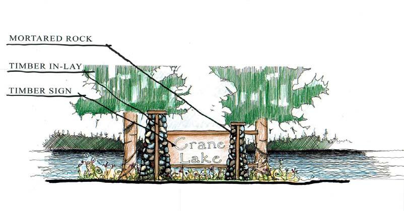
15 THE GATE TOWN SIGN THE GATE 30
THE SETTING REGION COMMUNITY ANALYSIS
 THE SETTING REGION COMMUNITY ANALYSIS REGION Historical Setting The Crane Lake waterway pre-dates the American Indians who traveled its waters for generations before it became a fur-trading route for the
CHAPTER 5. Chapter 5 Recreation Element
 CHAPTER 5 Recreation Element Chapter 5 Recreation Element The Recreation Element of the Meyers Area Plan is a supplement to the Recreation Element of the TRPA Regional Plan and the El Dorado County General
Lake Waconia Regional Park 6. Lake Waconia Regional Park
 Lower Lakeshore Trail Interpretive/Adventure Trail Multiple Seating & Observation Areas Flexible Day Use Recreation Area Docks/Fishing Group Camping Group Day Use Space Winter Gathering/Event Space -Season
Understanding the caring capacity of the visitor experience Provide facilities to support a high level user experience Address visual quality through
 Understanding the caring capacity of the visitor experience Provide facilities to support a high level user experience Address visual quality through recreation ecological restoration opportunities Collaboration
Wilds. Headwaters. Lakes. Oxbows. Falls
 56 5 4 3 Wilds Headwaters Lakes Oxbows Falls 57 Zones It could be said the on-the-ground essence of this master plan appears within the next 6 pages of this report. As we learned in the preceding Cultural
Dakota County Planning Commission Advisory Committee Meeting Minutes Date: May 23, 2017 Time: 6:00 p.m. to 8:30 p.m.
 Dakota County Planning Commission Advisory Committee Meeting Minutes Date: May 23, 2017 Time: 6:00 p.m. to 8:30 p.m. Members Present Staff Present Mike Greco Trinity Augesen Vacant Lori Hansen Jill Smith
NEWBORO AND PORTLAND HARBOUR REDVELOPMENT PLANS
 INTRODUCTION The Municipal docks in both Newboro and Portland were transferred to the Township of Rideau Lakes by Parks Canada in 2002. Little has been done to improve the docks physical condition or role
Everett Riverwalk Life style explore
 Life style explore Project Overview The 217-acre Everett Riverfront redevelopment is visible from I-5 with traffic counts charted at 170,000+ vehicles per day with direct freeway access from 4-way interchange.
Chapter 6. Trail Design. Trail Design
 Chapter 6 Trail Design Trail Design The trail winds through a region rich in scenic beauty, cultural, and natural history. Volunteer landscape architects working with the Core and Planning Teams, have
BACK COUNTRY UNIT PREFERRED ALTERNATIVE
 BACK COUNTRY UNIT PREFERRED ALTERNATIVE San Francisco (118 mi) Carmel-By-The-Sea Carmel River Carmel Valley Road State Beach Private Property Point Lobos State Reserve Point Lobos Ranch RUSTIC CAMPING
Stony Creek Master Plan Public Meeting #2. May 21, 2016
 Stony Creek Master Plan Public Meeting #2 May 21, 2016 Today s Agenda 10:00 10:20 am Presentation 10:20 10:45 am Q & A 10:45 11:30 am Browse, discuss, and comment Metroparks Master Plan Process 4 months
Welcome to the future of Terwillegar Park a Unique Natural Park
 Welcome to the future of Terwillegar Park a Unique Natural Park 1 Introduction The Terwillegar Park Concept Plan study will develop an overall concept plan, management objectives and development guidelines
Assessing Your Trails, Keeping Them Safe and Enjoyable
 Jon Wood, PLA, ASLA Associate Vice President Stewart Bert Lynn, PLA, ASLA, LEED AP Project Manager Mecklenburg County Asset and Facility Management Assessing Your Trails, Keeping Them Safe and Enjoyable
Proposal to Redevelop Lower Kananaskis River-Barrier Lake. Bow Valley Provincial Park. Frequently Asked Questions
 Proposal to Redevelop Lower Kananaskis River-Barrier Lake Bow Valley Provincial Park Frequently Asked Questions What is being proposed? What are the details of the proposal? Where is the project area located?
Preferred Recreation Recommendations Stemilt-Squilchuck Recreation Plan March 2018
 Preferred Recreation Recommendations Stemilt-Squilchuck Recreation Plan March 2018 Below are the recommended recreation ideas and strategies that package together the various recreation concepts compiled
Chapter 2: Summary of Existing Open Space System
 Chapter 2: Summary of Existing Open Space System In 1976, the Wake County Board of Commissioners established the Wake County Parks and Recreation Department in order to provide park facilities and programs
Silver Lake Park An Environmental Jewel for the Citizens of Prince William County
 Silver Lake Park An Environmental Jewel for the Citizens of Prince William County The Prince William Park Authority Mission Statement states: The Prince William County Park Authority will create quality
OR MISSION TRAIL ELEMENTARY
 Leawood: overview OVERLAD PARK 24: p.70 I-LA PARK 32: p.72 TOMAHAWK PARK 23: p.69 31: p.71 GEZER PARK OR MISSIO TRAIL ELEMETARY 22: p.68 W 133rd St W 135th St KASAS CITY MO - other segments Beginning/end
Business Item No
 Metropolitan Parks and Open Space Commission Meeting date: February 6, 2018 For the Community Development Committee meeting of February 20, 2018 For the Metropolitan Council meeting of February 28, 2018
COMMUNITY LOS PRIORITIES
 Part 5. Community Priority Meetings Purpose: The purpose of holding Community Priority Meetings was two-part; (1) to gather input from community members and decision makers on specific park and trail infrastructure
places Mooloolaba s heart five
 five places the mooloolaba heart 1 Flexible community event use of school oval 2 Enhanced streetscape District cycle route Future cross-block pedestrian link 5 Existing school buildings New signalised
Rogue River Access and Management Plan Draft Alternatives
 Rogue River Access and Management Plan Draft Alternatives The Rogue River Access and Management Plan was initiated in December, 2011 and is being led by Jackson County Parks (JCP) and Oregon Department
Lake Myra County Park. Wake County, North Carolina Community Forum #2 June 12, 2008
 Lake Myra County Park Wake County, North Carolina Community Forum #2 June 12, 2008 Welcome and Introduction Meeting Agenda Welcome Introductions of Project Team Master Plan Process Community Forum #1 Updates
DAKOTA CULTURE UPPER SIOUX COMMUNITY: AREA CHARACTER ANALYSIS ALIGNMENT STRATEGY
 UPPER SIOUX COMMUNITY: AREA CHARACTER ANALYSIS ALIGNMENT STRATEGY 51 AREA CHARACTER ANALYSIS: OPPORTUNITIES & CONSTRAINTS RECREATIONAL VEHICLE PARK: A recreational vehicle park will be built to accommodate
NAVAJO COMMUNITY PLAN
 NAVAJO COMMUNITY PLAN Prepared by the NAVAJO COMMUNITY PLANNERS and THE CITY OF SAN DIEGO City of San Diego Planning Department 202 C Street, MS 4A San Diego, CA 92101 Printed on recycled paper. This information,
River First Initiative and Waterworks Park
 River First Initiative and Waterworks Park The RiverFIRST proposal is critical to the creation of a larger regional parks and trails network, as well as ecological and infrastructure system. When realized,
Blue River Trail Master Plan JSA to Town Hall June 2004
 Blue River Trail Master Plan JSA to Town Hall June 2004 Prepared for: Silverthorne Town Council Silverthorne SPORT Committee Department of Recreation and Culture Silverthorne Public Works Silverthorne
PIONEER PARK. City of Des Peres Parks Master Plan. SWT Design 46 INTRODUCTION
 PIONEER PARK INTRODUCTION Pioneer Park is a 7 acre neighborhood park located east of Interstate 270 and south of Manchester Road along Tallie Road. The park is situated in a residential neighborhood with
Rating: 5.0 (scale of 1-10)
") 95 Community Trail System Groundcover: 2-metre paved path, 1- metre grass buffer on either side. Location: Fort St. John Ownership: City of Fort St. John Rating: 5.0 (scale of 1-10) Strategic value: Linear
95 Community Trail System Groundcover: 2-metre paved path, 1- metre grass buffer on either side. Location: Fort St. John Ownership: City of Fort St. John Rating: 5.0 (scale of 1-10) Strategic value: Linear
13.1 REGIONAL TOURISM ISSUES AND SUMMARY OF FINDINGS
 13 REGIONAL TOURISM T he County of Mariposa s recreation needs and facilities fall within two categories: regional tourism and local recreation. This Element focuses on regional tourism issues related
Proposal to Redevelop Lower Kananaskis River-Barrier Lake. Bow Valley Provincial Park
 Frequently Asked Questions Proposal to Redevelop Lower Kananaskis River-Barrier Lake Bow Valley Provincial Park Frequently Asked Questions What has been decided? What are the details of the plan? What
Greater Minnesota Regional Parks and Trails Commission Designation Application
 Greater Minnesota Regional Parks and Trails Commission Designation Application General Section Designation Application #: 15-050D Date Submitted: 06/30/2015 Park or Trail Name: Perham to Pelican Rapids
METROPOLITAN COUNCIL 390 North Robert Street, St. Paul, MN Phone (651) TDD (651)
 TDD (651)") METROPOLITAN COUNCIL 390 North Robert Street, St. Paul, MN 55101 Phone (651) 602 1000 TDD (651) 291 0904 DATE: June 19, 2007 TO: Metropolitan Parks and Open Space Commission FROM: Jan Youngquist, Senior
METROPOLITAN COUNCIL 390 North Robert Street, St. Paul, MN 55101 Phone (651) 602 1000 TDD (651) 291 0904 DATE: June 19, 2007 TO: Metropolitan Parks and Open Space Commission FROM: Jan Youngquist, Senior
City of Haslett. City of East Lansing. City of East Lansing
 Central Park North (Nancy L. Moore Park) Lake Park North Expansion White Park Expansion #2 White Park Expansion #1 County East East Haslett East East TF87-212 Acquisition $90,000.00 Park. TF08-138 Acquisition
STORY MILL COMMUNITY PARK
 OWNER: City of Bozeman Department or Parks and Recreation P.O. Box 1230, 415 N. Bozeman Street Bozeman, MT 59715 Tel: (406)-582-2908 APPLICANT: The Trust for Public Land 1007 E. Main Street, Suite 300
MASTER PLAN EXECUTIVE SUMMARY
 Biscuit Run State Park Scottsville Road (State Route 20) Charlottesville, VA 22902 Biscuit Run State Park MASTER PLAN EXECUTIVE SUMMARY Department of Conservation and Recreation Division of Planning and
Table of Contents. page 3 Long term Goals Project Scope Project History. 4 User Groups Defined Trail Representative Committee. 5 Trail Users Breakdown
 Launched April 27th, 2010 1 Table of Contents page 3 Long term Goals Project Scope Project History 4 User Groups Defined Trail Representative Committee 5 Trail Users Breakdown 13 Trail Users Desires 16
COCONUT GROVE WATERFRONT MASTER PLAN. ERA / Curtis Rogers / ConsulTech / Paul George Ph.D.
 COCONUT GROVE WATERFRONT MASTER PLAN ERA / Curtis Rogers / ConsulTech / Paul George Ph.D. Agenda City's Vision & Community Input Framework Concepts December 2006 Schemes Draft Final Plan Waterfront Open
Crystal Lake Area Trails
 Lake Area Trails Welcome to the Lake area of the Big Snowy Mountains! This island mountain range in central Montana features peaks reaching to 8,600 feet and long, high ridges from which vistas of the
CHAPTER 4 -- THE LAND USE PLAN: DESCRIPTIONS AND POLICIES FOR THIRTEEN PLANNING AREAS
 CHAPTER 4 -- THE LAND USE PLAN: DESCRIPTIONS AND POLICIES FOR THIRTEEN PLANNING AREAS NORTH CENTRAL CAC PLANNING AREA 4.4 FORT BRAGG CITY LIMIT TO HARE CREEK PLANNING AREA (Includes Noyo) The Noyo community
Business Item No XXX. Proposed Action That the Metropolitan Council approve the Coon Creek Regional Trail Master Plan.
 Business Item No. 2015-XXX Metropolitan Parks and Open Space Commission Meeting date: July 7, 2015 For the Community Development Committee meeting of July 20, 2015 For the Metropolitan Council meeting
Topsham Trail Guide.
 Topsham Trail Guide A guide to the walking, hiking, biking, water and ATV trails of Topsham, Maine and surrounding towns $4.95 Developed by the www.greatertopshamtrailalliance.org The Greater Topsham Trail
GLASS HOUSE MOUNTAINS PEAKS WALK, BEERBURRUM TRAILHEAD DRAFT CONCEPT PLAN
 GLASS HOUSE MOUNTAINS PEAKS WALK, BEERBURRUM TRAILHEAD DRAFT CONCEPT PLAN GLASS HOUSE Figure 1 REGIONAL WALK/RIDE OVERVIEW Aspirational Goal Create an interconnected nature-based recreation trail network
BRACEVILLE NATURE PRESERVE Introductions History Present Conditions Future Development Plans Implementation Strategies Statistics
 BRACEVILLE NATURE PRESERVE Introductions History Present Conditions Future Development Plans Implementation Strategies Statistics Introduction Braceville Nature Preserve is one of MetroParks largest preserves.
EXECUTIVE SUMMARY FALL Introduction. Findings
 EXECUTIVE SUMMARY FALL 2004 Introduction Trails are one of the most popular and highly desirable recreational resources in communities of all sizes throughout the country. In addition to providing a safe
Hudson Highlands Fjord Trail Draft Master Plan. April 29, 2015
 Hudson Highlands Fjord Trail Draft Master Plan April 29, 2015 Agenda Route Overview Proposed Segment Results of Community Survey on that Segment Next Steps Municipal Endorsement Environmental Review Implementation
THOMAS A. SWIFT METROPARK Introductions History Present Conditions Future Development Plans Implementation Strategies Statistics
 THOMAS A. SWIFT METROPARK Introductions History Present Conditions Future Development Plans Implementation Strategies Statistics Introduction As an open meadow park positioned along the Mahoning River,
Waukee Trailhead Public Art and Amenities Project
 Waukee - Trailhead Public Art and Amenities Project Sponsor Waukee Project Title Waukee Trailhead Public Art and Amenities Project Termini Description ( i.e. Park Avenue to 19th Street) NE Intersection
WATER PETALUMA TRAIL WATER WAYS PROJECT PORTFOLIO. petalumawaterways.org OVERVIEW
 WATER TRAIL PROJECT PORTFOLIO OVERVIEW Thirteen miles upstream of San Pablo Bay, Petaluma is the northern point on the San Francisco Bay Water Trail, a network of access points throughout the region. Most
TRUCKEE TAHOE AIRPORT DISTRICT BOARD OF DIRECTOR STAFF REPORT
 AGENDA ITEM: 11 TRUCKEE TAHOE AIRPORT DISTRICT BOARD OF DIRECTOR STAFF REPORT AGENDA TITLE: MEETING DATE: January 24, 2018 PREPARED BY: NTPUD Agency Partnership Opportunity, Multi-Use Trailhead Access
Committee Report. Community Development Committee For the Metropolitan Council meeting of August 12, Business Item No.
 Committee Report Business Item No. 2015-168 Community Development Committee For the Metropolitan Council meeting of August 12, 2015 Subject: Coon Creek Regional Trail Master Plan, Anoka County Proposed
CHAPTER 4 -- THE LAND USE PLAN: DESCRIPTIONS AND POLICIES FOR THIRTEEN PLANNING AREAS
 CHAPTER 4 -- THE LAND USE PLAN: DESCRIPTIONS AND POLICIES FOR THIRTEEN PLANNING AREAS NORTH CENTRAL CAC AREA LITTLE VALLEY ROAD TO JUG HANDLE CREEK PLANNING AREA This planning area includes Cleone, Noyo,
J. Recreation Plan of Conservation and Development. The Town of Hebron. Section 2. Preservation of Unique Assets. 1 P a g e
 The Town of Hebron Section 2 2014 Plan of Conservation and Development Preservation of Unique Assets J. Recreation Open spaces, parks, sports fields, and recreational programs are considered essential
Acquisition in fee simple of approximately one-half acre of property on the shore of Spring Lake to expand the Lakeside Beach Park.
 Lakeside Beach TF00-136 $122,550.00 in fee simple of approximately one-half acre of property on the shore of Spring Lake to exp the Lakeside Beach. 2000 River Ravines TF00-150 $910,000.00 in fee simple
THE REGION LAKE SUPERIOR THE GITCHI-GAMI TRAIL & THE NORTH SHORE
 LAKE SUPERIOR THE GITCHI-GAMI TRAIL & THE NORTH SHORE 7 LAKE SUPERIOR: Water covers 70% of the earth s surface area, but only 3% of it is freshwater. Saltwater makes up 97% of the earth s water supply.
Hiawatha National Forest St. Ignace Ranger District. File Code: 1950 Date: August 5, 2011
 United States Department of Agriculture Forest Service Hiawatha National Forest St. Ignace Ranger District W1900 West US-2 St. Ignace, MI 49781 906-643-7900 File Code: 1950 Date: August 5, 2011 Dear National
Blueways: Rivers, lakes, or streams with public access for recreation that includes fishing, nature observation, and opportunities for boating.
 Parks, Open Space and Trails PRINCE WILLIAM COUNTY 2008 COMPREHENSIVE PLAN TRAILS PLAN CONTENTS The components of the trails plan are: Intent Definitions Goals, Policies, and Action Strategies Trails Map
M E S T I Z O C U R T I S P A R K
 ARAPAHOE CONNECTION TO BUS ROUTE AT ND AND LAWRENCE, FUTURE LIGHT RAIL STATION LEGEND SOCIAL TRAIL FLAGSTONE PAVING TO RESTORE/MAINTAIN CONCRETE PAVING DIAGONAL CURVILINEAR SOCIAL ROUTE IS OUT OF HISTORIC
Information Requests. Street Car Wildlife Golden Valley Leash Ordinance/Dog Park
 Information Requests Street Car Wildlife Golden Valley Leash Ordinance/Dog Park (How we got here!) 1980 Plan for Wirth Park (Designated Master Plan) Wirth Lake/Picnic Area designated as a general recreation
Former Middle School Site Green Space & Brecksville Road Streetscape. March 27, 2018
 Former Middle School Site Green Space & Brecksville Road Streetscape March 27, 2018 Brecksville Streetscape & Downtown Greenspace Project Schedule City of Indepenence 2017 2018 Meeting Schedule Tasks/Deliverables
NORTHWEST SECTION CONTENTS: CLEVELAND PARK FOLWELL PARK RYAN LAKE PARK VICTORY PRAIRIE DOG PARK VICTORY PARK
 NORTHWEST SECTION CONTENTS: CLEVELAND PARK FOLWELL PARK RYAN LAKE PARK VICTORY PRAIRIE DOG PARK VICTORY PARK LUCY LANEY COMMUNITY SCHOOL N 33RD AVE N 33RD AVE SINGLE-FAMILY RESIDENTIAL MULTI-USE DIAMOND
The Vision for the San Juan Islands Scenic Byway
 The Vision for the San Juan Islands Scenic Byway 2 Judd Cove, Orcas Island, Courtesy of Kurt Thorson (kurtthorson.com) and San Juan County Land Bank Vision for the San Juan Islands Scenic Byway The San
Lewis and Clark Recreation Area
 Lewis and Clark Recreation Area Bicycle/Pedestrian Trail Also part of the Pierson Ranch Recreation Area trail Type of trail: Walking, biking and rollerblading Trail surface: Asphalt Rated: Mostly flat.
Summary of Recreation Sites Development Name:
 Development Name: Eau Pleine Site Number: 1 Owner: WVIC Eau Pleine Tailwater Boat Launch Lanes 1 Concrete plank landing, access to Eau Pleine tailwater & Lake DuBay. (45 planks long, 62.5') Picnic Tables
1. Overview of Aberdeen Township and Its Waterfront
 Aberdeen 1. Overview of Aberdeen Township and Its Waterfront 1.1 Geographic Overview Aberdeen Township is a suburban township with a land area of 5.45 square miles, with about 2 miles of shoreline along
Exclusive Riverfront Guest Lodge
 Exclusive Riverfront Guest Lodge On The Little Salmon River Kayla Adams Real Estate Professional Cell: 208-891-4669 Jaclyn Truppi Real Estate Professional Office: 208-628-4222 SalmonRiverProperties.com
A Vision for South Skunk River and Chichaqua Bottoms Greenbelt
 A Vision for South Skunk River and Chichaqua Bottoms Greenbelt Photo: Jim Pease Chichaqua Bottoms Booklet 7 of 8 Greater Des Moines Water Trails and Greenways 1 2016 Table of Contents Booklet 1: Water
Clearwater Lake Provincial Park. Draft Management Plan
 Clearwater Lake Provincial Park Draft Management Plan Clearwater Lake Provincial Park Draft Management Plan Table of Contents 1. Introduction... 3 2. Park History... 4 3. Park Attributes... 4 3.1 Location/Access...4
The striking colours of the setting sun reflecting on the waters is how Crimson Lake received its name. Crimson Lake Provincial Park is a meeting
 The striking colours of the setting sun reflecting on the waters is how Crimson Lake received its name. Crimson Lake Provincial Park is a meeting place of foothills forests in the west, bog and muskeg
Appendix 3. Greenway Design Standards. The Whitemarsh Township Greenway Plan
 Appendix 3 Greenway Design Standards This chapter discusses two design standards for the greenway types discussed above. First, trail design standards are presented together with trailhead facilities and
Mammoth Winter Recreation Summit Saturday March 19, 2016
 Mammoth Winter Recreation Summit Saturday March 19, 2016 Track: Winter Recreation at Shady Rest Presenter: Haislip Hayes- Town of Mammoth Lakes (TOML) Presentation Notes 1. 12.5 acres of Shady Rest Park
Chapter 9 Recreation
 Chapter 9 Chapter 9 1.0 INTRODUCTION The Town of Littleton is within one of New England s most important recreation areas. More than three million people live within 100 miles of the area. Local residents
Nov. 19 th Public Workshop Summary
 On November 19 th, more than 60 community members attended an Open Space Matters workshop at the Linen Building in downtown Boise for over two hours. Participants learned about reserves, discussed the
Cascade River State Park Management Plan Amendment
 This document is made available electronically by the Minnesota Legislative Reference Library as part of an ongoing digital archiving project. http://www.leg.state.mn.us/lrl/lrl.asp Cascade River State
2. Goals and Policies. The following are the adopted Parks and Trails Goals for Stillwater Township:
 D. PARKS AND TRAILS 1. Introduction Stillwater Township s population is relatively low, with most residents living on rural residences on large lots. The need for active park space has been minimal in
4.0 OUTDOOR RECREATION 4.1 PUBLIC LANDS
 4.0 OUTDOOR RECREATION 4.1 PUBLIC LANDS Public lands provide a wide range of recreational opportunities and are considered a valuable community asset. There may be seasonal and/or other use restrictions
PALO CORONA REGIONAL PARK MPRPD BOARD MEETING AUGUST 8, 2018
 PALO CORONA REGIONAL PARK MPRPD BOARD MEETING AUGUST 8, 2018 ACKNOWLEDGEMENTS AGENCIES AND ORGANIZATIONS The Trust for Public Land Big Sur Land Trust Santa Lucia Conservancy California State Parks Point
Dungeness Recreation Area County Park Master Plan
 Dungeness Recreation Area County Park Public Outreach Meeting October 10, 2007 Project Overview USFWS Site Dungeness Recreation Area County Park Meeting Objectives: Re-Introduce project; provide status
CHAPTER 9. PARKS, RECREATION, TRAILS AND NATURAL AREA RESOURCES
 CHAPTER 9. PARKS, RECREATION, TRAILS AND NATURAL AREA RESOURCES The forms of recreation chosen by residents and visitors in the CBJ are as diverse as the population. Many people choose to recreate in developed
Trail Towns Using Trail Systems To Leverage Place, Tourism, and Economic Development
 Trail Towns Using Trail Systems To Leverage Place, Tourism, and Economic Development Harry Burkholder, AICP Community Planner II 324 Munson Avenue Traverse City, MI 49686 231-929-3696 burkholder@liaa.org
Waterfront and Marina Strategic Plan. May 26, 2015 Infrastructure, Investment & Development Committee
 Waterfront and Marina Strategic Plan May 26, 2015 Infrastructure, Investment & Development Committee 1 Purpose Background Update work completed or underway Vision & principles Balanced plan with opportunities
Environment and Natural Resources Trust Fund 2019 Request for Proposals (RFP)
") Environment and Natural Resources Trust Fund 2019 Request for Proposals (RFP) Project Title: Glacial Edge Trail and Downtown Pedestrian Bridge Category: G. Land Acquisition for Habitat and Recreation ENRTF
Environment and Natural Resources Trust Fund 2019 Request for Proposals (RFP) Project Title: Glacial Edge Trail and Downtown Pedestrian Bridge Category: G. Land Acquisition for Habitat and Recreation ENRTF
MEETING MINUTES District 1 Trail Planning Meeting 1
 MEETING MINUTES District 1 Trail Planning Meeting 1 June 1, 2017 2:00 PM 3:30 PM City of Two Harbors 2:00 Introductions Attendees: Lisa Austin, MnDOT Bryan Anderson, MnDOT Jasna Hadzic-Stanek, MnDOT Justin
155 acres on Tyaughton Lake 900 feet of Pristine Waterfront Private & Secluded Property
 155 acres on Tyaughton Lake 900 feet of Pristine Waterfront Private & Secluded Property 946 Tyaughton Lake Road Gold Bridge BC V0K1P0 900 ft of waterfront with 155 acres of south facing easy access. This
Site Analysis. Context Plan ANALYSIS
 Site Analysis Context Plan The site located in Crosstown, occupies an entire city block bridging between the Downtown, Gastown, False Creek North, and Yaletown neighborhoods. It is bounded by W Georgia
Wallace Falls State Park Classification and Management Planning Stage 3 Preliminary Recommendations July 18, 2018 Sultan City Hall
 Wallace Falls State Park Classification and Management Planning Stage 3 Preliminary Recommendations July 18, 2018 Sultan City Hall Thanks for coming! This document contains State Parks preliminary recommendations
East Carolina Council Facility Study East Carolina Scout Reservation Camp Boddie Pamlico Sea Base
 East Carolina Council Facility Study East Carolina Scout Reservation Camp Boddie Pamlico Sea Base 1 VISION OF CAMP BODDIE EAST CAROLINA SCOUT RESERVATION 1. Attract Out Of Council Troops Use our natural
City of Solvang SUNNY FIELDS SPUR TRAIL STUDY
 City of Solvang SUNNY FIELDS SPUR TRAIL STUDY project description The City of Solvang, in partnership with the County of Santa Barbara Public Works Department, is developing an alignment study for a proposed
Public Comment. Comment To consider extending State Park lands above River Mile 7.0
 Public To consider extending Park lands above River Mile 7.0 on the Little Spokane River for the conservation and limited recreation qualities they contain is this request. Could this be included in your
NOTE: YOU MAY COMPLETE THIS SURVEY ONLINE (USING THIS DOCUMENT TO VIEW MAPS AND GRAPHICS) AT:
 AT:") for completing the Town of Beech Mountain Comprehensive Planning Survey. The information you provide in reply to the following questions will be used to help the Town develop a plan that will guide our
for completing the Town of Beech Mountain Comprehensive Planning Survey. The information you provide in reply to the following questions will be used to help the Town develop a plan that will guide our
SOUTH INTERCHANGE AREA
 Santaquin City General Plan 1 Location and Characteristics The South Interchange Area of Santaquin is located west of Interstate 15 and south of 500 South (Figure 1). It includes properties already annexed
ASRA 2018 Hike Schedule
 ASRA 2018 Hike Schedule Date/Day Destination Hike Info Meeting Info Leader Feb 10, Saturday Stagecoach and 9:00 at the Confluence kiosk. Manzanita trails Parking fee required. We ll hike along the trail
OAKLAND TOWNSHIP PARKS AND RECREATION MILLAGE RENEWAL AUGUST 2, 2016 BALLOT PROPOSAL QUESTIONS & ANSWERS PULL-OUT SECTION (APRIL 21, 2016)
") OAKLAND TOWNSHIP PARKS AND RECREATION MILLAGE RENEWAL AUGUST 2, 2016 BALLOT PROPOSAL QUESTIONS & ANSWERS PULL-OUT SECTION (APRIL 21, 2016) 2007 2016 Millage Accomplishments Timeline in Pull-out The Mission
OAKLAND TOWNSHIP PARKS AND RECREATION MILLAGE RENEWAL AUGUST 2, 2016 BALLOT PROPOSAL QUESTIONS & ANSWERS PULL-OUT SECTION (APRIL 21, 2016) 2007 2016 Millage Accomplishments Timeline in Pull-out The Mission
Keep Alaska Moving through service and infrastructure
 The West Glacier area of the Mendenhall Glacier Recreation Area is at the end the Skater s Cabin Road, accessed by streets maintained by the City and Borough of Juneau. The West Glacier area serves as
NEW MEADOWS PARK PROPOSED MASTER PLAN
 NEW MEADOWS PARK PROPOSED MASTER PLAN A vision for your neighborhood park, the draft master plan is ready for your review. Tuesday September 12 th, 2017 5:30-7:00 PM Hellgate School District #4 middle
MASTER PLAN MASTER PLAN
 LAKE JAMES LOOP TRAIL MASTER PLAN MASTER PLAN Lake James Loop Trail Work Group: Scott Black Burke Co. GIS Paul Braun Save Lake James Scott Carpenter Deputy Co. Manager Johnnie Carswell Burke Co. Commissioner
BRIAN HEAD AREA TRAILS MASTER PLAN. January 2015
 BRIAN HEAD AREA TRAILS MASTER PLAN January 2015.............. ACKNOWLEDGEMENTS & SIGNATURES Thanks to Brian Head Town s Trails Master Plan Development Committee who includes the key partners within the
A. SHAPING RECREATION DESTINATIONS
 A. SHAPING RECREATION DESTINATIONS Shaping SLV Communities into Recreation Destinations Great trails and recreation opportunities don t just satisfy local athletes, they can also attract tourists, boost
Camping (Primitive) Camping (RV) Electrical Potable Water Grill Established Fire Pit Picnic Table
 Camping (RV) Electrical Potable Water Grill Established Fire Pit Picnic Table") Alden - 9th Road River Mile 777 Map: 38.20833, -98.32031 Managing Agency: Kansas Department of Wildlife, Parks & Tourism Nearest Community: Alden, Rice County Kansas Developed Amenities Provided Parking
Alden - 9th Road River Mile 777 Map: 38.20833, -98.32031 Managing Agency: Kansas Department of Wildlife, Parks & Tourism Nearest Community: Alden, Rice County Kansas Developed Amenities Provided Parking
Webber Park Master Plan Charrette Summary
 SMALL GROUP #1 - September 29, 2011 Webber Park Master Plan Charrette Summary More trash cans, especially near picnic grounds A year round pool is very needed-physical & mental health are significantly