H1: BIRMINGHAM CURZON STREET STATION
|
|
|
- Edgar Richard
- 6 years ago
- Views:
Transcription
1 HIGH SPEED TWO INFORMATION PAPER H1: BIRMINGHAM CURZON STREET STATION This paper outlines the proposals for Curzon Street Station. It will be of particular interest to those potentially affected by the Government s proposals for high speed rail. This paper will be updated as required. If you have any queries about this paper or about how it might apply to you, please contact the HS2 Public Enquiries desk in the first instance. The Public Enquiries Team can be reached at: by HS2enquiries@hs2.org.uk High Speed Two (HS2) Limited 2nd Floor, Eland House Bressenden Place London SW1E 5DU or by Phone: (lines are open Monday to Friday 9am-5pm) Version 1.1 Last updated 13 May
2 H1: BIRMINGHAM CURZON STREET STATION 1. Introduction 1.1. High Speed Two (HS2) is the Government s proposal for a new, high speed northsouth railway. The proposal is being taken forward in two phases: Phase One will connect London with Birmingham and the West Midlands; and Phase Two will extend the route to Manchester, Leeds and beyond HS2 Ltd is the non-departmental public body responsible for developing and promoting these proposals. The company works to a remit set by the Secretary of State for Transport. Recently, HS2 Ltd deposited a hybrid Bill 1 with Parliament to seek powers for the construction and operation of Phase One of HS2 (sometimes referred to as the Proposed Scheme ). The Bill is the culmination of four years of work, including an Environmental Impact Assessment (EIA), the results of which were reported in an Environmental Statement (ES) submitted alongside the Bill. The Secretary of State has also published draft Environmental Minimum Requirements (EMRs), which set out the environmental and sustainability commitments that will be observed in the construction of HS2. The Bill will be promoted through Parliament by the Secretary of State for Transport (the promoter ). The Secretary of State will also appoint a body responsible for delivering the Proposed Scheme under the powers granted by the Bill. This body is known as the 'nominated undertaker'. There may well be more than one nominated undertaker for example, HS2 Ltd could become the nominated undertaker for the main railway works, while Network Rail could become the nominated undertaker for works to existing stations such as Euston and Birmingham. But whoever they are, all nominated undertakers will be bound by the obligations contained in the Bill and the policies established in the EMRs. These information papers have been produced to explain the commitments made in the Bill and the EMRs and how they will be applied to the design and construction of HS2. They also provide information about the Proposed Scheme itself, the powers contained in the Bill and how particular decisions about the project have been reached. This paper outlines the proposals for Curzon Street Station. 1 The High Speed Rail (London West Midlands) Bill, hereafter the Bill. 2
3 2. Overview 2.1. The HS2 terminus station at Curzon Street in Birmingham will be one of the largest new stations built in Britain in 100 years. An estimated 25,000 passengers will use it each day in This will increase to 66,000 in 2041, six years after completion of both Phases of HS2. The station will not only offer significant journey time reductions to other stations on the high speed network, but provide onward connection to numerous other local and national services at the nearby Moor Street, New Street and Snow Hill Stations. Figure 2.1 HS2 route Curzon Street was selected as the location for the Birmingham terminus station in part due to its proximity to the other central Birmingham stations that will provide onward journeys to the wider rail network. The station will be connected to local bus networks and there is further potential opportunity for interchange with a future Metro tram service currently being explored by Centro and Birmingham City Council. Curzon Street station has the potential to be a catalyst for regeneration in Birmingham Eastside and has been the focus of Birmingham City Council development plans for Eastside and Digbeth, outlined in their emerging Birmingham Curzon master plan 2 which is part of their Big City Plan. 2 Birmingham Curzon master plan for growth, Birmingham City Council, February
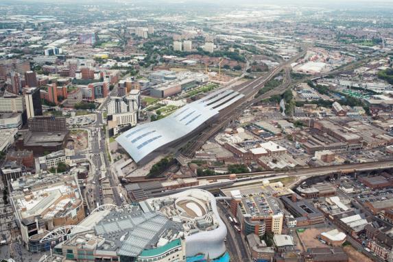
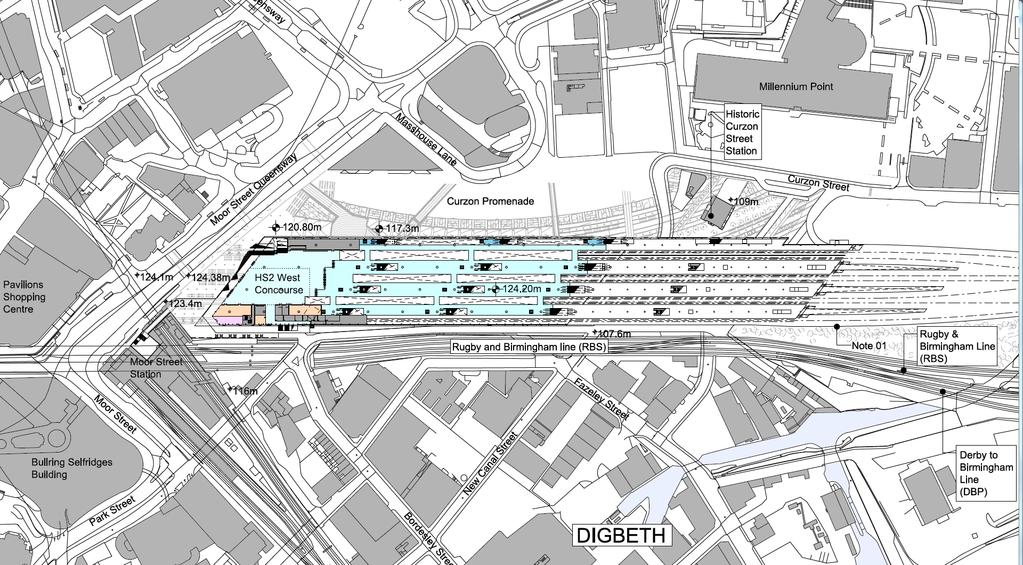
4 3. Why Curzon Street? Eight options were considered for a terminus station in central Birmingham, including upgrades and expansions of Moor Street, Snow Hill and New Street stations or development of a completely new station. Extending New Street would offer the best solution for passengers, but unfortunately it is not feasible. Even if the cost could be justified, an additional new station would be required somewhere else in the city, and existing trains services would be severely disrupted during construction. Extension of Snow Hill would also present fundamental problems as the shallow tunnels at either end would need to be rebuilt. Because of its orientation, Moor Street is not compatible with the route via the Water Orton corridor. It was concluded that a new station would be needed as all the other options had significant engineering, capacity and/or land use constraints The site 4.1. Of the options for a new terminus station for the Water Orton corridor route, the two best locations were Warwick Wharf and Fazeley Street (now known as Curzon St). Either would deliver broadly the same passenger benefits, but Warwick Wharf would bisect the Warwick Bar Conservation Area and the local street pattern, would affect a number of listed buildings and would create greater local severance. It would also be marginally more expensive to build. Fazeley Street was therefore selected. It is proposed that the station and associated infrastructure be built on land between the West Coast Main Line and the recently completed Eastside City Park. The site is next to Moor Street Station and approximately 400m north east of New Street Station. The whole site including the fan of tracks to the platforms is around 900m long, of which station building would occupy approximately 550m. It is currently mostly used for open space, temporary parking or is vacant Between Moor Street Queensway to the west and New Canal Street in the middle of the site, the ground level falls approximately 17m but further east it is flat. There are two vacant public houses on the site - the Grade 2 listed but derelict Fox and Grapes and the locally listed Eagle and Tun. There are a number of heritage assets located in the vicinity including the Grade 1 listed former Curzon Street station building immediately to the north. At the eastern end of the construction site HS2 will cross the Digbeth Branch Canal. 4

5 Figure 4.1 Curzon Street Station Site The Bullring 5. Operational requirements 5.1. The station will provide sufficient access and circulation space for passengers not only to circulate within the station building but also for pedestrian and vehicular access to the station. It is necessary to ensure that the platforms, escalators, concourses and circulation areas have sufficient capacity for maximum passenger flows including predicted future growth The station will provide level access to all public and staff areas, and lifts in addition to stairs and escalators for access to all levels. Provision for access to and from the station will include cars and delivery vehicles, taxis and buses, cycle facilities and storage, and welcoming pedestrian entrances. No all-day station car parking will be provided as part of the HS2 scheme. 6. The proposal 6.1. Until the Bill is enacted, the station design is at concept stage. The layout has been planned so that it would comply with operational requirements and statutory regulations. It defines the scale and massing of the buildings and structures so that their environmental effects can be assessed. Detailed designs for both the station building and the external areas will be prepared in due course. They will be submitted to the local planning authority for approval before construction The current proposal comprises seven HS2 platforms and a station building containing ticket halls and concourse, waiting areas, retail, welfare, passenger 5
6 information facilities. Figure 6.1 shows the concept layout. The current conceptual design for the station (as set out in this Information Paper) includes provision for a segregated international platform and passenger facilities which would allow for HS2 trains to run directly to the continent. There will be a study into ways to improve connections to the continent that could be implemented once the initial stages of HS2 are complete. This design may need to be revisited once the study has reported The main entrance faces Moor Street Queensway giving direct and convenient access to the adjacent Moor Street Station, the city centre and local bus services. A second entrance is proposed from New Canal Street to provide both pedestrian access to the immediate locality and to the east, and also to provide vehicular access to the station. 6
7 Figure 6.1; Aerial View of proposed Curzon Street Station 7
8 8
9 Figure 6.2 Site Layout 9
10 10


11 From the east, the HS2 line crosses two railway lines and the A4520 Ring Road on a viaduct crossing New Canal Street 8-9m above ground level, but due to the slope of the land, at the Moor Street Queensway end the platforms are approximately 7m below street level. A street level upper concourse above the platforms is proposed at this end and there will also be a lower concourse underneath the platforms at New Canal Street level so that passengers can enter at ground level at both ends of the station. Vehicular access to the station will be via Curzon Street and New Canal Street and would include a taxi rank, taxi drop-off points, provision for kiss and ride drop-off and short term car parking. At this stage it is assumed that a future Metro tram route would include stops at both entrances to the station. Figure 6.3: Illustrative station layout Main concourse (Moor Street Queensway) level Platform level Lower concourse (New Canal Street) level 11
12 7. Station design principles 7.1. The station design will provide: a gateway to Birmingham; enhanced connectivity to the wider rail network and other modes of transport; and a potential catalyst to regeneration in Eastside, Digbeth and the wider city region HS2 Ltd has adopted consistent design aspirations for all stations in order to set high standards and enhance the passenger experience. The design requirements for Curzon Street Station are as follows: the station will respond to the contextual and social needs of its immediate environment and contribute as fully as possible to its future development. It is anticipated that it will become a significant architectural landmark and a catalyst for regeneration; the station will evolve from a robust and adaptable concept that can respond to changing demands on its scope and delivery; it will provide a clear sequence of spaces for passengers arriving, leaving and interchanging, which are easy for station users to navigate; the architecture will adopt a simple and refined choice of materials. Clear forms and a generous scale will give the station a classic and timeless style; and the station design will put the environment and sustainability at its core. It will embody best practice where appropriate, integrating technology in low maintenance economic solutions. 12

13 Figure 7.1: Illustrative View from Upper Concourse 8. Access to and from the station 8.1. The majority of passengers using HS2 Curzon Street Station are forecast to access the station on foot, primarily interchanging to/from other trains at other Birmingham stations. A limited number of people are forecast to arrive / leave the station by car. This is in line with the Birmingham Eastside master plan development principle for increased pedestrianisation and public reliance on cycling, bus and urban rail networks. It is likely that the majority of passengers will use the main entrance on Moor Street Queensway. 13

14 Figure 8.1: Artist s impression of the north side of Curzon Street Station 8.2. Passengers arriving by taxi or private vehicles will approach the station from the east - from the A4540, via Curzon Street to New Canal Street. Cars will leave the station to the south along New Canal Street. Taxis will leave along the new road to the south of the station and then south-west along Park Street. Internal roads will provide access for taxis and car pick-up and dropoffs, short-term and staff car parking and service vehicles and emergency vehicles. Table 9.1: Estimated total passengers entering or exiting the station during the AM peak hour 2026 Boarders/Alighters (total expected passengers between each weekday) Car (all day parking in existing car parks) Car (kiss and ride) Taxi Bus Walk/Cycle Other trains TOTAL Table 9.1 shows the estimated split by mode of onward transport of HS2 passengers at Curzon Street during the AM peak hour (between each weekday). In 2026 it is estimated that around 43% will be walking to / from other Birmingham railway stations, around 19% will be travelling by bus and around 27% will be walking or cycling. It is likely that a small number will 14

15 park in existing car parks in the vicinity. There will be no provision for long stay parking at Curzon Street station itself. 9. Highway works 9.1. Construction of the station will necessitate permanent closure of parts of Park Street and Fazeley Street, though New Canal Street will be re-opened after construction is complete. Some of the traffic currently on Park Street will transfer to Moor Street Queensway but the remainder will divert to Curzon Street and the ring road. As the ring road junctions at Curzon Circle and Garrison Circus are currently operating at or near capacity at peak times, improvements to these junctions are included in the Proposed Scheme Other transport infrastructure improvements include: Diversion and widening of Curzon Street around the Woodman public house. New access roads to the east and south of the station. Provision of pedestrian bridge link over the Digbeth viaduct. Figure 9.1: Illustrative Eastern entrance and Curzon Street taxi rank 15

16 10. Land required Only the land for the railway, the station and the access and circulation areas will be required permanently. However, during construction a more extensive area is needed for temporary work sites both to build the station and undertake the necessary works to the adjacent roads, including the ring road junctions. Figure 10.1 shows the extent of the land that may be required. When construction is complete, any surplus land will be considered for disposal in accordance with the project s land policies (see Information Paper C6: Disposal of Surplus Land). Figure 10.1: Land required permanently and during construction 11. Construction The construction of Curzon Street Station will take approximately five years to complete, commencing in 2018, with another year for fit-out. Areas within the Curzon Street Station compound will be used to provide short term storage of materials Construction planning is still at an early stage but further detail can be found in the London-West Midlands Environmental Statement (ES Volume 2). 12. Environmental effects Curzon Street station will become a landmark architectural feature, transform the regeneration potential of the surrounding area, and will offer opportunities for new urban spaces and other public realm improvements in 16
17 an under-used area of inner Birmingham. It will also provide the opportunity to improve the setting of the former Curzon Street station building The main effects of implementation of the scheme are: Demolition of student accommodation in Curzon Street and a community building in Erskine Street; Demolition of Grade 2 listed Fox and Grapes public house. In addition, there will be modifications to the locally listed Eagle and Tun public house on New Canal Street to integrate the building within the proposed Curzon Street station structure; Loss of open space in Park Street and Eastside City parks; Loss of mediaeval remains in Freeman Street and other archaeological deposits elsewhere on the site During construction, noise, atmospheric emissions and other adverse environmental effects will be controlled in accordance with the Environmental Minimum Requirements including the Code of Construction Practice (CoCP), which will include a range of mitigation measures to reduce impacts as far as reasonably practicable. It also makes provision for the preparation of local environmental management plans (LEMPs) to include local environmental and community protection measures. Contractors are required to manage noise, dust, air pollution, odour and exhaust emissions during construction works. Details of the proposed environmental regime can be found in the HS2 Environmental Statement in Volume 2, CFA4 Report, the Draft Code of Construction Practice and the Environmental Memorandum. The environmental protection regime is described in Information Paper E1: Control of Environmental Impacts. Amongst other things, specific mitigation measures include: Protection of the former Curzon Street station building and the Woodman public house during construction and enhancement of their settings. Pedestrian link bridge over the Digbeth railway viaduct to Moor Street station Protection the Digbeth Branch Canal during construction and improving public access on completion Details of the proposed environmental mitigation regime can be found in the HS2 Environmental Statement in Volume 2, CFA4 Report, the Draft Code of Construction Practice and the Environmental Memorandum. 17
18 13. Regeneration opportunities As part of its Big City Plan for regeneration and expansion of Birmingham City Centre, in February 2014 Birmingham City Council produced a masterplan for the Birmingham Curzon area around the station including Eastside and Digbeth. The masterplan is a long term vision to provide around 14,000 additional new jobs and over 2,000 new homes by the middle of the century. The master plan includes a creative quarter centred on Digbeth, retail and business development around the station and a research, technology and education hub focussed on Aston University and the planned Birmingham City University campus The regenerative effect of Curzon Street station would also extend far wider than the Birmingham area. The overall Big City Plan ambition for central Birmingham is a 20 year vision for Birmingham s City Centre supporting transformational change to create a world class city centre delivering sustainable growth, improved connectivity, authentic character, environmental quality, new residential communities and a diversified economic base. It covers an area of 800 hectares and includes a spatial strategy for growing the City Core by over 25%. The whole of the city centre will benefit from the enhanced connectivity to London, Manchester, Leeds and the other conurbations and to international airports provided by HS More information More detail on the Bill and related documents can be found at: 18
In your area. Manchester Piccadilly Station MA08. June Introduction. High Speed Two (HS2) is
 is") June 2018 www.hs2.org.uk In your area Manchester Piccadilly Station MA08 High Speed Two (HS2) is A57(M) A5067 Manchester A5103 A5067 Newton Street Piccadilly A34 A665 Store Street A6 Manchester Sheffield
June 2018 www.hs2.org.uk In your area Manchester Piccadilly Station MA08 High Speed Two (HS2) is A57(M) A5067 Manchester A5103 A5067 Newton Street Piccadilly A34 A665 Store Street A6 Manchester Sheffield
In your area. Stourton to Hunslet LA17. June Introduction. High Speed Two (HS2) is
 is") June 2018 www.hs2.org.uk In your area Stourton to Hunslet LA17 High Speed Two (HS2) is to Leeds M621 HUNSLET A639 STOURTON M621 A61 M1 A63 A639 M1 HS2 Phase 2b to Birmingham the Government s planned new
June 2018 www.hs2.org.uk In your area Stourton to Hunslet LA17 High Speed Two (HS2) is to Leeds M621 HUNSLET A639 STOURTON M621 A61 M1 A63 A639 M1 HS2 Phase 2b to Birmingham the Government s planned new
Vision Planning for Metropolitan Areas. Ian Macleod Head of Development (East) and Planning Strategy Birmingham City Council
 and Planning Strategy Birmingham City Council") Vision Planning for Metropolitan Areas Ian Macleod Head of Development (East) and Planning Strategy Birmingham City Council The Regeneration Story Past and present 1950-1960: Motor City Planning for the
Vision Planning for Metropolitan Areas Ian Macleod Head of Development (East) and Planning Strategy Birmingham City Council The Regeneration Story Past and present 1950-1960: Motor City Planning for the
Chapter 2 Route window W25 Maidenhead station. Transport for London
 Chapter 2 Route window W25 Maidenhead station MAIDENHEAD STATION 2 Route window W25 Maidenhead station 2.6 The drawings provided at the end of this chapter present the main features of the route window,
In your area. Stonebroom to Clay Cross LA09. June Introduction
 June 2018 www.hs2.org.uk In your area to Clay Cross LA09 Midland Main Line Shirland Tupton Clay Cross A61 Stretton Midland Main Line to Chesterfield and Sheffield Pilsley A6175 HS2 Phase 2b spur Morton
Delivering and Investing in Future Infrastructure Projects
 Delivering and Investing in Future Infrastructure Projects Inside Government 29 th March Ian MacLeod Assistant Director Planning and Regeneration Birmingham City Council Scale of Growth Housing 150,000
This paper outlines the development of the HS2 scheme since the then Government decided to set up HS2 Ltd and explore options in January 2009.
 HIGH SPEED TWO INFORMATION PAPER A1: DEVELOPMENT OF THE HS2 PROPOSED SCHEME This paper outlines the development of the HS2 scheme since the then Government decided to set up HS2 Ltd and explore options
Calderdale MBC. Wards Affected: Town. Economy and Investment Panel: 20 October Halifax Station Gateway Masterplan
 Calderdale MBC Wards Affected: Town Economy and Investment Panel: 20 October 2016 Halifax Station Gateway Masterplan Report of the Acting Director, Economy and Environment 1. Purpose of the Report 1.1
Chapter 21 Route window W6 West Ealing station. Transport for London
 Chapter 21 Route window W6 West Ealing station WEST EALING STATION 21 Route window W6 West Ealing station Baseline conditions 21.6 West Ealing station is located in the London Borough of Ealing and is
PART VIII APPLICATION FOR REVISED SOUTH SIDE TRAFFIC MANAGEMENT WORKS TO FACILITATE LUAS BXD PLANNING REPORT ROADS & TRAFFIC DEPARTMENT
 PART VIII APPLICATION FOR REVISED SOUTH SIDE TRAFFIC MANAGEMENT WORKS TO FACILITATE LUAS BXD PLANNING REPORT ROADS & TRAFFIC DEPARTMENT NOVEMBER 2012 1.0 INTRODUCTION This report has been prepared in support
In your area. Pinxton to Newton and Huthwaite LA08. June Introduction
 June 2018 www.hs2.org.uk In your area Pinxton to Newton and Huthwaite LA08 to Chesterfield and Sheffield Westhouses Blackwell Newton M1 South Normanton to Leeds Hilcote 28 Pinxton Huthwaite A38 HS2 Phase
The Hybrid Bill and the journey to Royal Assent. Andy Taylor Head of Public Affairs, HS2 Ltd
 The Hybrid Bill and the journey to Royal Assent Andy Taylor Head of Public Affairs, HS2 Ltd HS2 one railway, two phases 330 miles of new track 9 HS2 stations High speed trains running on HS2 and existing
In your area. South Kirkby to Sharlston Common LA14. June Introduction
 June 2018 www.hs2.org.uk In your area South Kirkby to Sharlston Common LA14 A645 to Leeds A628 A638 Sharlston A639 Crofton Wragby HS2 Phase 2b Wintersett A638 Kinsley Ryhill A628 Hemsworth A6201 South
Welcome. Welcome to our public exhibition which explains our proposed changes to the Brentford Community Stadium development, at Lionel Road South.
 Welcome Recent aerial view of the site with Griffin Park, the existing stadium, in the background. Welcome to our public exhibition which explains our proposed changes to the Brentford Community Stadium
In your area. Tibshelf to Shuttlewood LA10. June Introduction
 June 2018 www.hs2.org.uk In your area Tibshelf to Shuttlewood LA10 LA10 M1 Calow Arkwright A632 Town Long Duckmanton Cock Alley Temple Normanton A617 Grassmoor Heath Holmewood North Wingfield Sutton Scarsdale
SOUTH CAMBRIDGESHIRE DISTRICT COUNCIL. Executive Director / Senior Planning Policy Officer
 SOUTH CAMBRIDGESHIRE DISTRICT COUNCIL REPORT TO: Leader and Cabinet 8 May 2008 AUTHOR/S: Executive Director / Senior Planning Policy Officer SOUTH CAMBRIDGESHIRE DISTRICT COUNCIL S RESPONSE TO UTTLESFORD
London and Crossrail 2. Chris Moores Transport for London
 London and Crossrail 2 Chris Moores Transport for London 1 Contents 2 1 The region needs Crossrail 2 2 Crossrail 2 can be more than just a railway 3 Planning and Delivering Crossrail 2 Issues facing London
TERMINAL DEVELOPMENT PLAN
 5.0 TERMINAL DEVELOPMENT PLAN 5.0 TERMINAL DEVELOPMENT PLAN Key points The development plan in the Master Plan includes the expansion of terminal infrastructure, creating integrated terminals for international,
Chapter 16 Route Window NE15 Brentwood station. Transport for London
 Chapter 16 Route Window NE15 Brentwood station BRENTWOOD STATION 16 Route Window NE15 Brentwood station Introduction 16.1 The construction activities in this route window are associated with minor refurbishment
Major Scheme Business Case Summary Report for Programme Entry
 Paper A Heart of South West Local Transport Board Major Scheme Business Case Summary Report for Programme Entry M5 Junction 25, Taunton July 2016 1 SCHEME SUMMARY Scheme Name M5 Junction 25, Taunton Date
In your area. Warmfield to Swillington and Woodlesford LA15. June Introduction
 June 2018 www.hs2.org.uk In your area Warmfield to Swillington and Woodlesford LA15 LA15 Rothwell to Leeds A642 M62 M1 Woodlesford Oulton Bottom Boat to York HS2 Phase 2b Altofts A642 Swillington Methley
5 Rail demand in Western Sydney
 5 Rail demand in Western Sydney About this chapter To better understand where new or enhanced rail services are needed, this chapter presents an overview of the existing and future demand on the rail network
Chapter 6 Route Window NE5 Seven Kings station. Transport for London
 Chapter 6 Route Window NE5 Seven Kings station Transport SEVEN KINGS STATION 6 Route Window NE5 Seven Kings Station Transport Introduction 6.1 All construction activities in this route window are associated
Bloor Street West Rezoning Application for a Temporary Use By-law Final Report
 STAFF REPORT ACTION REQUIRED 3741 3751 Bloor Street West Rezoning Application for a Temporary Use By-law Final Report Date: June 12, 2007 To: From: Wards: Reference Number: Etobicoke York Community Council
GRAND CENTRAL BIRMINGHAM
 FACT FILE JANUARY 2014 GRAND CENTRAL BIRMINGHAM Anchored by a full line John Lewis Store, Grand Central Birmingham will bring over 40 new premium and high quality stores and more than 20 new concept cafes
Report to: Greater Cambridge Partnership Joint Assembly 18 January A10 Foxton level crossing bypass and travel hub
 Report to: Greater Cambridge Partnership Joint Assembly 18 January 2018 Lead officer: Chris Tunstall GCP Director of Transport A10 Foxton level crossing bypass and travel hub 1. Purpose 1.1 The list of
Welcome to public consultation for the redevelopment of the existing leisure centre site.
 www.southwark.gov.uk Welcome to public consultation for the redevelopment of the existing leisure centre site. The design strategies and drawings presented here show how the projects are developing. Design
Chapter 4 Route Window NE3 Manor Park station. Transport for London
 Chapter 4 Route Window NE3 Manor Park station MANOR PARK STATION 4 Route Window NE3 Manor Park station 4.7 Highway access to Manor Park station is very good. A117 Station Road connects with A116 to the
High Speed Two: From Crewe to Manchester, West Midlands to Leeds and beyond
 High Speed Two: From Crewe to Manchester, West Midlands to Leeds and beyond Phase 2b Route Decision Moving Britain Ahead July 2017 September 2016 High Speed Two: From Crewe to Manchester, West Midlands
Draft City Centre Transport Proposals
 Draft City Centre Transport Proposals Introduction This draft position paper provides an overview of the current City Centre transport issues, including concepts of the possible future City Centre transport
JOINT CORE STRATEGY FOR BROADLAND, NORWICH AND SOUTH NORFOLK EXAMINATION MATTER 3C EASTON/COSTESSEY
 Matter 3C Easton/Costessey Representor No. 8826 JOINT CORE STRATEGY FOR BROADLAND, NORWICH AND SOUTH NORFOLK EXAMINATION MATTER 3C EASTON/COSTESSEY SUBMISSION ON BEHALF OF TAYLOR WIMPEY DEVELOPMENTS AND
November 11, 2009 BY . Planning and Growth Management Department 110 Laurier Avenue West, 4 th Floor Ottawa, Ontario K1P 1J1. Dear Mr.
 November 11, 2009 Planning and Growth Management Department 110 Laurier Avenue West, 4 th Floor Ottawa, Ontario K1P 1J1 BY E-MAIL Attention: Mr. Don Herweyer Dear Mr. Herweyer: Reference: Abbott-Fernbank
As part of our transport vision, Leeds City Council, working with the West Yorkshire Combined Authority and Leeds Bradford Airport Company, is
 As part of our transport vision, Leeds City Council, working with the West Yorkshire Combined Authority and Leeds Bradford Airport Company, is considering options for improving surface access and connectivity
HISTORY IN THE MAKING. The UK s most important city centre development outside London. Being delivered by:
 UPDATE JANUARY 2016 HISTORY IN THE MAKING The UK s most important city centre development outside London. Being delivered by: THE HEART OF THE CITY St Philip s Square Birmingham Museum & Art Gallery A
WELCOME. Members of the development team are on hand to answer questions and feedback forms are available for your comments.
 WELCOME Thank you for attending our public consultation in respect of TJX Europe s proposed new landmark office building opposite Watford Junction Station. The purpose of the consultation is to present
A. CONCLUSIONS OF THE FGEIS
 Chapter 11: Traffic and Parking A. CONCLUSIONS OF THE FGEIS The FGEIS found that the Approved Plan will generate a substantial volume of vehicular and pedestrian activity, including an estimated 1,300
WELCOME TO PROJECT EVERGREEN 3 CHILTERN S PROPOSED NEW OXFORD TO LONDON ROUTE
 PROJECT EVERGREEN 3 WELCOME TO PROJECT EVERGREEN 3 CHILTERN S PROPOSED NEW OXFORD TO LONDON ROUTE Chiltern Railways is proposing a railway improvement scheme between Oxford and Bicester (the Evergreen
A Master Plan is one of the most important documents that can be prepared by an Airport.
 The Master Plan A Master Plan is one of the most important documents that can be prepared by an Airport. A Master Plan is a visionary and a strategic document detailing planning initiatives for the Airport
LEEDS. INNOVATIVE INFRASTRUCTURE DELIVERY Creating a catalyst for regeneration and unlocking investment opportunities. Leeds Railway Station
 LEEDS INNOVATIVE INFRASTRUCTURE DELIVERY Creating a catalyst for regeneration and unlocking investment opportunities Leeds Railway Station INTRODUCTION Leeds is at the centre of the Northern Powerhouse
Pre-application submission for Committee: Phase 4 development at West Hendon
 Pre-application submission for Committee: Phase 4 development at West Hendon 1. Development Details Phase 4 of the West Hendon Estate Regeneration. 2. Background The redevelopment of the West Hendon Estate
N4 Carrick-on-Shannon to Dromod Road Project. 2.1 Introduction
 Chapter 2 Need for the Scheme 2.1 Introduction The National Primary Route N4, Dublin to Sligo is a strategic corridor from Dublin to the northwest and border counties (See RCSR 101 in Volume 2). The National
HS2 Plans & Updates. Prof Andrew McNaughton
 HS2 Plans & Updates Prof Andrew McNaughton 2 High Speed Rail is 48 Years Old 3 It Continues to Evolve Technically World High Speed Rail Expansion Km 40000 35000 30000 25000 20000 15000 10000 5000 0 1964
Threats to possible orbital light-rail in outer London from the current Brent Cross planning application...
 Threats to possible orbital light-rail in outer London from the current Brent Cross planning application... (We need safeguarding in place, for better times!) Map from Transport 2025 document. Boris photo:
Chapter 13 Route Window NE12 Harold Wood station. Transport for London
 Chapter 13 Route Window NE12 Harold Wood station HAROLD WOOD STATION 13 Route Window NE12 Harold Wood station 13.8 Harold Wood station is on Gubbins Lane close to the junction of A12 Colchester Road and
Appendix 9. Impacts on Great Western Main Line. Prepared by Christopher Stokes
 Appendix 9 Impacts on Great Western Main Line Prepared by Christopher Stokes 9 IMPACTS ON GREAT WESTERN MAIN LINE Prepared by Christopher Stokes Introduction 9.1 This appendix evaluates the impact of
TRANSPORT UPDATE. September/October 2018
 TRANSPORT UPDATE September/October 2018 TRANSPORT UPDATE Below is a list of the main local, regional and national transport projects that the Chamber is involved with, either directly or indirectly. Mention
Bridge School, Longmoor Campus, Coppice View Road, Sutton Coldfield, Birmingham, B73 6UE
 Committee Date: 22/01/2015 Application Number: 2014/05949/PA Accepted: 08/12/2014 Application Type: Full Planning Target Date: 02/02/2015 Ward: Sutton Vesey Bridge School, Longmoor Campus, Coppice View
Llandudno Junction. Regeneration Proposals for the Future. December 2009
 Llandudno Junction Regeneration Proposals for the Future December 2009 Llandudno Junction - Vision Statement 1 Purpose 1.1 The purpose of this document is to describe key priorities to support the regeneration
Non-technical summary
 Introduction NTS1 NTS2 NTS3 Troika Developments Ltd (Troika) has submitted a planning application to Bournemouth Borough Council (BBC) for an extension of time to implement planning permission 7/2004/16450/G,
Gold Coast. Rapid Transit. Chapter twelve Social impact. Chapter content
 Gold Coast Rapid Transit Chapter twelve Social impact Chapter content Social impact assessment process...235 Existing community profile...237 Consultation...238 Social impacts and mitigation strategies...239
APP/P4.1 Eddie Mellor Transport Planning Main Proof of Evidence
 Eddie Mellor Transport Planning Main Proof of Evidence APP/P4.1 TRANSPORT AND WORKS ACT 1992 PROPOSED MIDLAND METRO (BIRMINGHAM EASTSIDE EXTENSION) ORDER 201[x] PROOF OF EVIDENCE OF Eddie Mellor Transport
Guildford Borough Transport Strategy 2017, Topic Paper: Transport, June 2017 (accompanying Local Plan 2017) Local Plan Transport Strategy 2017
 Local Plan Transport Strategy 2017") Guildford Society Transport Group Position Paper August 2017 Based on submissions in response to the June/July 2017 Local Plan consultation including material presented to Drop-in Session 15 July 2017.
Guildford Society Transport Group Position Paper August 2017 Based on submissions in response to the June/July 2017 Local Plan consultation including material presented to Drop-in Session 15 July 2017.
Airdrie - Bathgate Railway and Linked Improvements Bill. Environmental Statement Page 1
 Environmental Statement Page 1 1.0 INTRODUCTION 1.1 The Scheme Proposal The scheme proposals are to re-open the Airdrie to Bathgate section of the former Bathgate and Coatbridge Railway (Monklands Railway)
Part four. In this part you will find: The next steps to deliver the master plan
 Part four NEXT STEPS In this part you will find: The next steps to deliver the master plan 6. How COULD the Master Plan be delivered? There are a number of steps required to take the proposals in the master
Chapter 4 Route window W23 Taplow station. Transport for London
 Chapter 4 Route window W23 Taplow station TAPLOW STATION 4 Route window W23 Taplow station 4.6 Baseline conditions Taplow station Taplow station is located in South Buckinghamshire, 1.5 km southeast of
Infrastructure for Growth
 A passion to deliver a prosperous future Connecting North Cambridgeshire Infrastructure for Growth Infrastructure for growth Wisbech is the largest settlement in Fenland. The town and its hinterland has
Board meeting
 Board meeting 28.11.17 Secretariat memorandum Author: Vincent Stops Agenda item: 8 Ref: LTW568 Drafted: 13.11.17 Oxford Street bus changes associated with pedestrianisation 1 Purpose of report 1.1. To
An Introduction to HS2
 July 16 1 Overview HS2 is a vital part of the Government s long term economic plan, strongly supported by midland, northern English and Scottish cities. HS2 will not be a separate, standalone railway.
Local Development Scheme
 Local Development Scheme August 2014 Local Development Scheme (August 2014) / Page 2 Contents Section 1: Introduction Great Yarmouth s Development Plan 4 Section 2: Plan Making Process Public participation
Maidenhead Bridge. Proposed Work
 W1.1 Maidenhead Bridge Proposed Work The Maidenhead Bridge over the River Thames at Maidenhead is a Grade II* listed structure. Installation of overhead electrification on top of the structure would be
9.1 INTRODUCTION 9.2 EXISTING DEVELOPMENT. Southern Cross University
 Property Strategy The property strategy delivers improved legibility, responds to the locational attributes of the site, and facilitates essential operational efficiencies. 9.1 INTRODUCTION Non-aviation
BARNSLEY METROPOLITAN BOROUGH COUNCIL
 BARNSLEY METROPOLITAN BOROUGH COUNCIL This matter is a Key Decision within the Council s definition and has been included in the relevant Forward Plan REPORT OF THE EXECUTIVE DIRECTOR OF PLACE TO CABINET
TRANSPORT AND WORKS ACT 1992 THE TRANSPORT AND WORKS (APPLICATION AND OBJECTIONS PROCEDURE)(ENGLAND AND WALES 2006
(ENGLAND AND WALES 2006") Rule 10(2)(d) TRANSPORT AND WORKS ACT 1992 THE TRANSPORT AND WORKS (APPLICATION AND OBJECTIONS PROCEDURE)(ENGLAND AND WALES 2006 THE MIDLAND METRO (WOLVERHAMPTON CITY CENTRE EXTENSION) ORDER REPORT SUMMARISING
Rule 10(2)(d) TRANSPORT AND WORKS ACT 1992 THE TRANSPORT AND WORKS (APPLICATION AND OBJECTIONS PROCEDURE)(ENGLAND AND WALES 2006 THE MIDLAND METRO (WOLVERHAMPTON CITY CENTRE EXTENSION) ORDER REPORT SUMMARISING
The Point Roundabout Improvement Scheme
 The Point Roundabout Improvement Scheme Background and Existing Situation The junction of North Wall Quay, East Wall Road and the East Link Bridge, also known as the Point roundabout, is located in the
TORONTO TRANSIT COMMISSION REPORT NO.
 Revised: March/13 TORONTO TRANSIT COMMISSION REPORT NO. MEETING DATE: November 18, 2013 SUBJECT: YONGE-EGLINTON AND EGLINTON WEST INTERCHANGE STATIONS METROLINX EGLINTON CROSSTOWN LIGHT RAIL TRANSIT PROJECT
Birmingham City Centre Vision for Movement
 Birmingham City Centre Vision for Movement Wes Sedman - Centro Commissioning Team Laying the foundations for a vibrant and liveable global city Birmingham Big City Plan - A City Centre Masterplan A vision
THE FUTURE S HERE. Page 1
 THE FUTURE S HERE Page 1 Page 2 THE FUTURE FOR BIRMINGHAM IS EASTSIDE LOCKS, FORMING PART OF EASTSIDE, BIRMINGHAM S MAJOR REGENERATION PROJECT. THIS VIBRANT NEW QUARTER FOR THE CITY WILL CREATE A MIXED
BRENT CROSS THAMESLINK
 INTRODUCTION The 4.5 billion Brent Cross Cricklewood development is Barnet Council s most significant growth and regeneration programme. It will create a new sustainable mixed use town centre for Barnet
Appendix. Gatwick Airport Ltd - Further information on Gatwick s revised phasing strategy (including Programme) Gatwick Airport Limited
 Gatwick Airport Limited") Gatwick Airport Limited Response to Airports Commission Consultation Appendix 37 Gatwick Airport Ltd - Further information on Gatwick s revised phasing strategy (including Programme) Further information
Gatwick Airport Limited Response to Airports Commission Consultation Appendix 37 Gatwick Airport Ltd - Further information on Gatwick s revised phasing strategy (including Programme) Further information
PLANNING THE SUNBURY GROWTH CORRIDOR
 SUNBURY GROWTH CORRIDOR NOVEMBER 2016 PLANNING THE SUNBURY GROWTH CORRIDOR Sunbury Planning Background The Victorian Planning Authority, in consultation with Hume City Council, is undertaking a number
Sky Temporary Car Park Transport Statement
 001 Issue 26 August 2016 This report takes into account the particular instructions and requirements of our client. It is not intended for and should not be relied upon by any third party and no responsibility
CABINET 1 MARCH 2016 DEVELOPMENT OF A RAIL STRATEGY FOR LEICESTER AND LEICESTERSHIRE REPORT OF THE DIRECTOR OF ENVIRONMENT AND TRANSPORT PART A
 21 Agenda Item 5 CABINET 1 MARCH 2016 DEVELOPMENT OF A RAIL STRATEGY FOR LEICESTER AND LEICESTERSHIRE REPORT OF THE DIRECTOR OF ENVIRONMENT AND TRANSPORT Purpose of the Report PART A 1. To present the
EAST WEST RAIL EASTERN SECTION. prospectus for growth
 EAST WEST RAIL EASTERN SECTION prospectus for growth September 2018 executive summary The East West Rail Consortium, a partnership of local authorities, rail operators and Network Rail, continues to promote
TORONTO TRANSIT COMMISSION REPORT NO.
 Revised: March/13 TORONTO TRANSIT COMMISSION REPORT NO. MEETING DATE: March 26, 2014 SUBJECT: KENNEDY INTERCHANGE STATION: METROLINX EGLINTON CROSSTOWN LIGHT RAIL TRANSIT PROJECT - PRELIMINARY CONCEPT
TOWN PLANNING SUBMISSION TO THE GREATER SYDNEY COMMISSION LANDS AT ARTARMON
 TOWN PLANNING SUBMISSION TO THE GREATER SYDNEY COMMISSION LANDS AT ARTARMON March 2017 TABLE OF CONTENTS 1.0 INTRODUCTION 3 2.0 THE SUBJECT SITE 4 3.0 STRATEGIC PLANNING CONTEXT 6 4.0 SUMMARY AND CONCLUSIONS
Business Case Approved. Under Construction. Business Case Approved. Under Construction
 Item 6 Appendix A: LGF Project Summary for South Essex Update September Project and A127 Network Resilience (Essex) Basildon Integrated Transport Package (Essex) Range of improvements at key locations
Roundhouse Way Transport Interchange (Part of NATS City Centre Package)
") Roundhouse Way Transport Interchange (Part of NATS City Centre Package) 15/16 16/17 17/18 18/19 19/20 Total TOTAL COST Roundhouse Way Transport Interchange 0.5m 0.5m FUNDING CIL 0.05m 0.05m Growth Deal
Roundhouse Way Transport Interchange (Part of NATS City Centre Package) 15/16 16/17 17/18 18/19 19/20 Total TOTAL COST Roundhouse Way Transport Interchange 0.5m 0.5m FUNDING CIL 0.05m 0.05m Growth Deal
Next Generation Cycleway Design. Improving connectivity and cycling behaviours through design
 Next Generation Cycleway Design Improving connectivity and cycling behaviours through design Safe segregation between Place Users to offer improved safety and a defined space for each user group Elevated
Greenwich Peninsula Investor and Analyst Day 12 March 2013 Quintain Estates and Development PLC
 Greenwich Peninsula Investor and Analyst Day 12 March 2013 Agenda Maxwell James Chief Executive Anthony Gill Development Director, Greenwich Overview Greenwich Peninsula 2 Quintain Strategy Delivering
Chapter 14 Route Window C12 Mile End Park and Eleanor Street shafts. Transport for London
 Chapter 14 Route Window C12 Mile End Park and Eleanor Street shafts MILE END PARK AND ELEANOR STREET SHAFTS 14 Route Window C12 Mile End Park and Eleanor Street shafts Introduction 14.1 Crossrail s twin
Enterprise and Business Scrutiny Panel
 Enterprise and Business Scrutiny Panel Keren Jones, Service Director, City Economy Marie Bintley, Head of City Development 03 February 2015 Citywide Economic Context Business and enterprise: 8,065 Businesses
WELCOME WELCOME TO OUR PUBLIC EXHIBITION FOR THE BOND STREET PUBLIC REALM PROJECT.
 WELCOME WELCOME TO OUR PUBLIC EXHIBITION FOR THE BOND STREET PUBLIC REALM PROJECT. Bond Street Development Plan is one of the key initiatives outlined in the West End Partnership s vision. Bond Street
ASHTON GATE SPORTS & CONVENTION CENTRE. A New Home For Bristol Flyers
 ASHTON GATE SPORTS & CONVENTION CENTRE A New Home For Bristol Flyers THE VISION I n 2016 Ashton Gate/ Bristol Sport delivered the 45m redevelopment of the home of Bristol City FC and Bristol Bears Rugby.
A TRANSPORT SYSTEM CONNECTING PEOPLE TO PLACES
 THE MAYOR'S VISION FOR TRANSPORT A TRANSPORT SYSTEM CONNECTING PEOPLE TO PLACES VISION We will build a transport system that works for everyone, connecting people to the places they want to go within the
Map showing location of public transport projects in vicinity of railway station
 Map showing location of public transport projects in vicinity of railway station Market Town Transport Strategy 2013 39 ID PT1a Specific Location Approach at Detail of Project Develop Area Master plan
CONTENTS. 1 Introduction Always Moving Forward while Building on the Past A Dynamic Destination... 5
 2010 STRUCTURE PLAN - 2 - CONTENTS 1 Introduction... 5 1.1 Always Moving Forward while Building on the Past... 5 1.2 A Dynamic Destination... 5 2 Map A... 6 Exhibition Place and its Neighbours... 7 3 Demonstration
The implementation of this Master Plan will be undertaken in logical stages to meet passenger and workforce demands.
 The implementation of this Master Plan will be undertaken in logical stages to meet passenger and workforce demands. Connecting People Building Opportunities 198 Brisbane Airport Corporation CHAPTER 10
URBAN DESIGN REPORT. Proposed Residential Development, Old Church Road, Caledon East
 Proposed Residential Development, Old Church Road, Caledon East TABLE CONTENTS: 1.0 DEVELOPMENT 1.1 Introduction-Analysis of Guiding Principles and Documents 1.2 Community Design and Architectural Design
Scala House, 36 Holloway Circus, Queensway, Birmingham, B1 1EQ
 Committee Date: 31/10/2013 Application Number: 2013/06196/PA Accepted: 15/08/2013 Application Type: Full Planning Target Date: 14/11/2013 Ward: Nechells Scala House, 36 Holloway Circus, Queensway, Birmingham,
Bartlett Square Welcome. Investment Framework. London Airport Ltd
 1 Welcome Welcome to Luton s public exhibition on proposals for the (formerly known as Stirling Place) project which will comprise 2.5 acres of commercial development, providing up to 2,000 jobs for local
Movement Strategy. November On behalf of Barton Oxford LLP
 Movement Strategy November 2014 On behalf of Barton Oxford LLP BARTON PARK, OXFORD. Movement Strategy 17/11/2014 Quality Management Issue/revision Issue 1 Revision 1 Revision 2 Revision 3 Remarks Date
Stage 2 ION: Light Rail Transit (LRT) from Kitchener to Cambridge
 from Kitchener to Cambridge") Stage 2 ION: Light Rail Transit (LRT) from Kitchener to Cambridge Public Consultation Centre (PCC) No. 3 Please Sign-in Cambridge City Hall November 21, 2017 2:00 to 8:00pm Preston Memorial Auditorium
Stage 2 ION: Light Rail Transit (LRT) from Kitchener to Cambridge Public Consultation Centre (PCC) No. 3 Please Sign-in Cambridge City Hall November 21, 2017 2:00 to 8:00pm Preston Memorial Auditorium
AECOM Metro Wolverhampton City Centre Extension (WCCE) Transport Assessment 55
 Transport Assessment 55") AECOM Metro Wolverhampton City Centre Extension (WCCE) Transport Assessment 55 10.3.7 AL07: Castle Street Large vehicles turning left from Piper s Row to Castle Street may be restricted when a tram is
AECOM Metro Wolverhampton City Centre Extension (WCCE) Transport Assessment 55 10.3.7 AL07: Castle Street Large vehicles turning left from Piper s Row to Castle Street may be restricted when a tram is
CITY OF EDINBURGH COUNCIL WRITTEN SUBMISSION
 CITY OF EDINBURGH COUNCIL Summary WRITTEN SUBMISSION Waverley and Haymarket are significant stations for Scotland as well as Edinburgh. The number of passengers using them has grown substantially in recent
Section A: Scheme Summary
 Section A: Scheme Summary Name of Scheme: PMO Scheme Code: Lead Organisation: Senior Responsible Officer: Lead Promoter Contact: Case Officer: North East Calderdale Transformational Programme WYTF-PA4-054
Strategic Transport Forum
 Strategic Transport Forum Friday 16 th March 2018 www.englandseconomicheartland.com Item 3: Innovation www.englandseconomicheartland.com Innovation work stream - EEH 1. Policy modelling 2. MaaS 3. EEH
Caloundra South overview Ben Allen, General Manager Sustainable Communities
 CONTENT Caloundra South overview Ben Allen, General Manager Sustainable Communities Planning and Approvals status update Marc Wilkinson, QLD Planning and Approvals Manager Masterplanning and delivery Ben
A63 Castle Street, Hull HullBID Network Lunch 24 August 2017
 A63 Castle Street, Hull HullBID Network Lunch 24 August 2017 James D Leeming Senior Project Manager What we will cover today? Introduction to Highways England and the Road Investment Strategy A63 Scheme
Doncaster Chamber of Commerce. Andy Taylor Head of Public Affairs, HS2 Ltd
 Doncaster Chamber of Commerce Andy Taylor Head of Public Affairs, HS2 Ltd HS2 one railway, two phases 330 miles of new track 9 HS2 stations High speed trains running on HS2 and existing lines Up to 18
The Government s Aviation Strategy Transport for the North (TfN) response
 response") The Government s Aviation Strategy Transport for the North (TfN) response Transport for the North Background Good transport links are a crucial part of a strong economy supporting labour markets and delivering
The Government s Aviation Strategy Transport for the North (TfN) response Transport for the North Background Good transport links are a crucial part of a strong economy supporting labour markets and delivering