SAN ANTONIO FIELD TRIP William E. Doolittle Department of Geography and the Environment The University of Texas at Austin
|
|
|
- Lambert Warner
- 6 years ago
- Views:
Transcription
: dam, canal, aqueduct, fields 2.")
1 Topics to be covered SAN ANTONIO FIELD TRIP William E. Doolittle Department of Geography and the Environment The University of Texas at Austin 1. Importance of water for life in the Southwest Acequia system (irrigation): dam, canal, aqueduct, fields 2. Spanish Institutions: (a) missions (spread of Christianity) (b) presidios (military and government) (c) towns (civilian settlement) 3. Historic precedents and the contemporary cityscape. Painting of San Antonio in 1836 by George Nelson
2 ITINERARY 8:30 a.m. Depart UT, corner of 23 rd Street and San Jacinto Street 10:00 Arrive at Espada Dam Stop 1 10:40 Depart Espada Dam 10:45 Arrive at Ashley Street canal crossing Stop 2 10:55 Depart Ashley Street stop 11:00 Arrive at Espada Aqueduct Stop 3 11:20 Depart Espada Aqueduct 11:25 Arrive at Mission Espada Stop 4 Noon Depart Mission Espada 12:15 Arrive at Mission San José Stop 5 1:30 Depart Mission San José 1:45 Arrive at the San Antonio city hall parking lot Stop 6 1:50 Visit the Spanish Governor's Palace (We will enter as a group, but once inside will take individual self-guided tours.) 2:10 Walk around the Plaza de las Armas, San Fernando Cathedral, and the Plaza de las Islas 2:30 Depart city hall parking lot 4:00 p.m. Arrive back at UT, corner of 23rd and San Jacinto 2
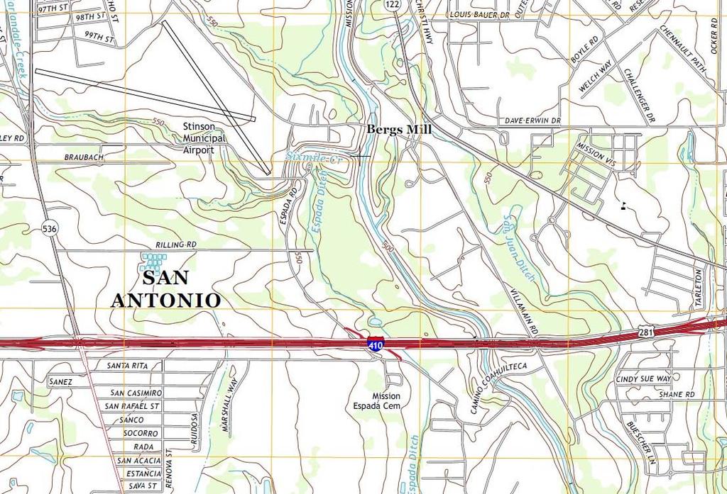
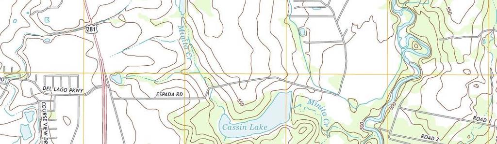
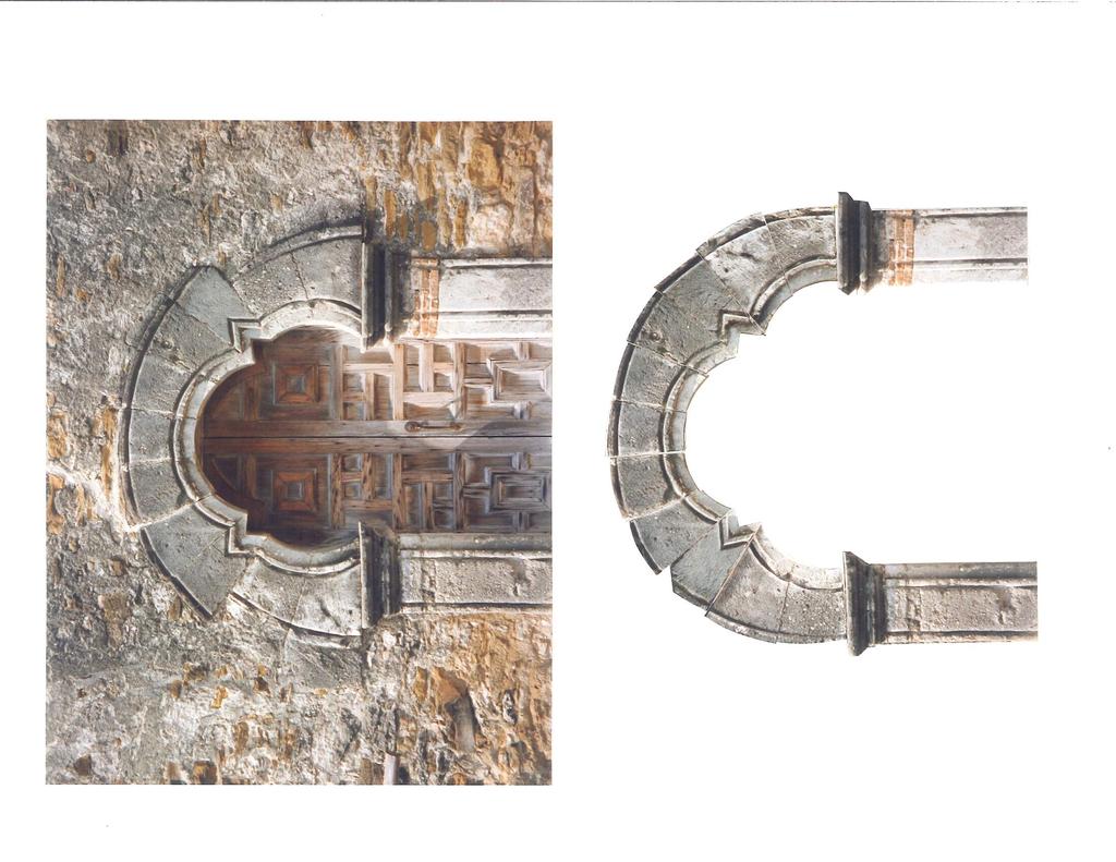
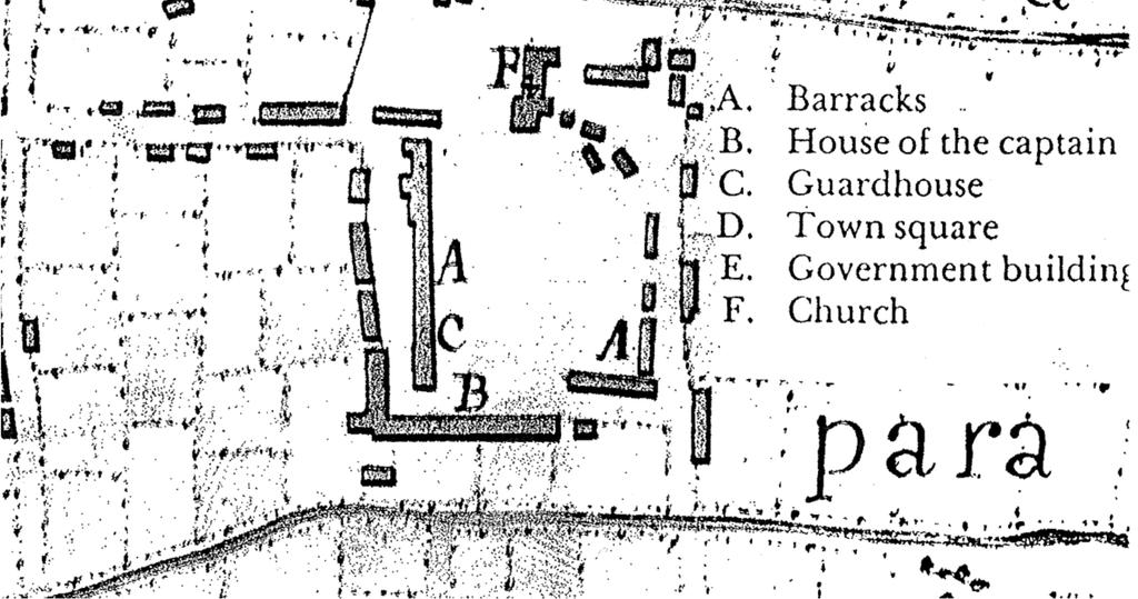
3 Table of Contents 4 Map of the City of San Antonio with stops numbered (stops 1-6) 5 The San Antonio Missions (a brief history) by Adán Benavides 6 Population of Texas missions by Tina Meacham 7 National Park Service Mission Trail Map 8 Google Earth image of irrigated mission lands (stops 1-4) 9 USGS topographic map (stops 1-5) 10 Engineering map of Espada dam, canal, aqueduct (stops 1-3) 11 Engineering drawing of Espada Dam (stop 1) 12 Engineering drawing of Espada Aqueduct (stop 3) 13 Menchaca map from 1764 from the John Carter Brown Library 14 Aqueduct? What Aqueduct? 15 Engineering map of Espada fields (stop 4) 16 Map of Espada long lots 17 Incorrectly rebuilt door frame of Espada mission 18 Schematic layout of Mission San José (stop 5) 19 Engineering drawing of Mission San José grist mill 20 Spanish Governor s Palace brochure (stop 6) 21 Presidio Captain s House brochure 22 Presidio map drawn by Urrutia in 1767 from the British Library, and an enlarged portion of Menchaca s map 23 Acequia o Arroyo? 24 An enlargement and translation of a portion of Urrutia s map 25 Early photographs of military and civilian plazas 26 Civilian population of San Antonio in 1700s th century maps of downtown San Antonio by Dan Arreola 28 Map of current city streets affected by 18 th century canal 29 Suggested additional readings 3

4
5 From Adán Benavides, ed., The San Antonio River Valley: Notes for the Participants of the Gran Quivira Conference XX, Goliad-San Antonio, Texas, October 1991, pp The San Antonio Missions Adán Benavides The basic premises of the missionary enterprise on the northern reaches of Nueva España are well-known to even the casual observer of what is now the U.S. Southwest: the Spanish government and the Hispanic church sought to convert the native peoples. At its simplest level, conversion was in the view of the latter a religious experience; but to the former, it meant the acculturation of the New World natives to the Spanish way of life. In practice, however, the goals of the two Hispanic institutions were inseparable. On the frontier, the gobierno de indios was administered through church clerics. In contemporary times, the positive and negative effects of the conversion process have been brought into sharp relief as we approach 12 October Between 1718 and 1731, five missions were established along the upper San Antonio River: San Antonio de Valero ("The Alamo"), San José y San Miguel de Aguayo, Nuestra Señora de la Purísima Concepción, San Francisco de la Espada, and San Juan Capistrano. In the latter year, the three last-named missions were removed from east Texas and, with their property and supplies, reestablished along the San Antonio River. These changes followed the recommendations of the Rivera inspection which streamlined the presidios along the frontier of New Spain. Franciscan friars from the Apostolic Colleges of Querétaro and Zacatecas administered the Texas missions. Following the expulsion of the Jesuits in 1767 from New Spain, the Querétaran Franciscans assumed responsibility for the Jesuit missions in the northwestern interior provinces and thereby abandoned the Texas field. Thus in 1773, the Zacatecan Franciscans assumed the jurisdiction of the five San Antonio missions four were added to the one of San José which they had had since The proximity of the five San Antonio missions occurred because rivalry among the various Coahuiltecan Indian bands prevented their congregation in fewer missions. In 1745, they were described as being more than 200 tribes, speaking twenty different languages or dialects. A Franciscan friar produced a confessional manual in Coahuiltecan for use in the missions (Mexico, 1760). The mission populations were never very extensive (see table 1). At their population maximums, the Indians at a single San Antonio mission have been estimated at 200 to 350 individuals. In the early years, European diseases took their toll among the mission Indians in epidemics (of smallpox and measles, for example) that also affected the Spanish village and presidio. Following the 1770s, the mission populations were not significantly increased by neophytes. In the early 1790s, however, descendants of older Indian converts (as well as other agregados) acquired a share in the mission buildings and fields following the "secularization" of the missions. In the latter part of the eighteenth century, secularization was an empire-wide attempt to lessen the financial burden of the Spanish Crown, which significantly supported the missionary enterprise. In this process, the diocesan or "secular" clergy assumed the administration of the former mission congregations from the "regular" clergy clergy like the Franciscan friars who followed specific rules (regula) of a spiritual order. In Texas, secularization involved property and land grants which were further legalized under the Mexican regime in The missions were independent pueblos that included the mission compound (chapel, convento, plaza, perimeter dwellings, workshops, and storerooms), fields irrigated by a dam and acequia system, and a ranch of sizable proportions for loose livestock. During the nineteenth century, the mission compounds deteriorated: stones from the walls were sold and used in newer constructions, the chapels were sometimes used as livestock pens, and domes, roofs, and towers fell (except Mission Concepción's chapel, which has remained intact). In the twentieth century, the mission compounds received extensive reconstruction by the WPA (especially Mission San José), maintenance by both the Catholic Church and the State of Texas, and, more recently, support from the National Park Service. The latter has linked the four lower missions into a National Historical Park. The chapels at all four of the missions, moreover, are now active churches and those of San José and Espada are again administered by the Franciscan Order. 5

6 6
7 South Presa Street San Pedro Creek Exit 155A Exit 155B Lone South Flores Street South Star Probandt Street Santa Rosa Street Alamo Boulevard El Mercado Dolorosa Street SAN Street Durango Travis Street Houston Street King William District ANTONIO RIVER South St Mary s Street Lone Star Boulevard South Presa Street St Mary s Street Alamo Navarro Street Riverwalk Street LosoyaStreet Broadway North Alamo Street Commerce Street Market Street Convention Center HEMISFAIR PLAZA Tower of the Americas Institute of Texan Cultures Boulevard The Alamo Bowie Street Exit 140 Exit 141B Exit 141A Alamodome Probandt Street East Theo Probandt Street exit Avenue Mitchell Street Mission Road Mission Road Felisa Street Roosevelt Avenue Steves Avenue CONCEPCIÓN PARK Mission Concepción SAN ANTONIO RIVER Approximate site of Mission San Francisco Xavier Nájera (no access) Mission Road Mission Parkway Park Headquarters Southcross Boulevard Southcross Boulevard Exit 138A Mission Road White Avenue MISSION COUNTY PARK To exit 150B, 35 South Flores Street 536 SW Military Drive Ashley Road Pyron Street Mission San José (San José Mission State Historic Site) Roosevelt Avenue Sixmile Creek New Napier Avenue Loop 13 San Mission Road March Avenue José Drive Napier Avenue Caution: Low overpass 10ft 10in (3.3meter) clearance STINSON MUNICIPAL AIRPORT Mission Road (detour when Mission Trail is closed by high water) Padre Drive Visitor Center Padre Drive ESPADA PARK PADRE PARK Espada Dam Warning: Use caution when water flows over road. Acequia de Espada San Juan Dam (no access) New Espada Dam Roosevelt Avenue Ashley Road Espada Road One-way frontage road One-way frontage road Chavaneaux Road Ashley Road Ashley Espada Road Road Padre Drive 23 miles (37 kilometers) from Visitor Center to Rancho de las Cabras via South Presa Street and 181 ACEQUIA PARK Acequia de San Juan SE Military Drive Loop 13 BROOKS AIR FORCE BASE Acequia (historic irrigation ditch within park boundary) Used today for Unwatered, no longer irrigation used for irrigation North Mission Trail driving tour (see map for Picnic area detour when Mission Trail is closed by high water in river) Kilometer Mile 281 Exit Espada Aqueduct Mission Espada Acequia de Espada (historic Piedras Creek) LABORES DE ESPADA (no access) Nature Trail LABORES DE SAN JUAN (no access) Graf Road Villamain Road Camino Coahuilteca Mission San Juan Warning: Use caution when water flows over road. South Presa Street Acequia de San Juan Shane Road Southton Road To Rancho de las Cabras Exit 42

8

9
10
11 11 1
12 12 3

13 3 1 3? 4 13
14 Aqueduct? What aqueduct? Note that the Menchaca map of 1764 on the previous pages (full map and an enlarged section) shows a dam [stop 1], an acequia [stop 2] as part of the Mission Espada [stop 4] irrigation system, but no aqueduct [stop 3] over Piedras Creek, which is also not shown. The first written description of an aqueduct here dates to 1772 and was provided by one Fray Saenz, who noted a: " conduit of lime and stone of thirty eight varas [105.5 feet]; six [16.6 feet] in height; with its diamond point, and two arches, which allow the currents of said creek to pass " (Cox 1999:321) This is clearly a description of the present aqueduct. The disparity between the map of Menchaca and the description by Saenz has led to speculation that the present aqueduct was built sometime between 1764 and 1772, and that prior to then a less permanent aqueduct, something not unlike the "flumes" or canoas (hollowed-out split tree trunks supported by a wooden framework) common in northern New Mexico, was used. 14
15 4 15
16
17

18 18 5
19 19 5
20 6 20
21 6 21

22 ? 6 Urrutia s map of ? Menchaca s map of
23 Acequia o Arroyo? Note that the maps on the previous page differ. Both show the San Antonio River. However, on the west side of the river, Urrutia's 1767 map shows two irrigation canals and no arroyo, whereas Menchaca's 1764 map shows an arroyo and no canal. This confusion goes all the way back to the early explorations and the reason why this site was chosen for a presidio and mission. On 5 April 1709, Fray Isidro de Espinosa, Fray Antonio de Olivaras, Captain Pedro de Aguirre and 14 soldiers left the Presidio San Juan Bautista on the Río Grande (south of present-day Piedras Negras/Eagle Pass) to reconnoiter central Texas. According to Espinosa's diary, on 13 April: " dimos en una acequia de agua muy poblada de arboles que era suficiente para un pueblo, y toda llena de tomas de agua por estar alta la acequia y colgadas las tierras pusimosle por nombre el agua de S. Pedro." (Foster 1995:99) " we came to an irrigation ditch, bordered by many trees and with water enough to supply a town. It was full of taps or sluices of water, the earth being terraced. We named it San Pedro Spring." (Tous 1930:5) Some scholars (Foster 1995:99, 302; Weber 1992:163) interpret this to mean that natives of the area not only were agricultural, but irrigated as well. Others (e.g., Doolittle 2000) argue otherwise, in part because no crops were mentioned. Most scholars (e.g., Almaráz 1989; de la Teja 1995) recognize it as simply a misidentification Espinoza saw a spring-fed stream and thought it was an acequia; Urrutia did likewise, Menchaca didn't. On another note, Isleños, or Canary Islanders who arrived in 1731 to found the civil settlement, are claimed by their descendants and one scholar (Glick 1972:29) to have built the first irrigation canal in San Antonio. In fact, however, construction on the first canal was carried out by presidio soldiers in (Castañeda 1936:96; Fox 1985:1). 23

24 6 24


25 Military Plaza, San Antonio, Texas ca Engraving by James D. Smillie, from the William H. Emory, Report on the United States and Mexican Boundary Survey, The Church of San Fernando before 1867 and after 1840s remodeling. Stereo view slide collection of Albert Steves. Source: the Witte Museum. 25

26 26


27 Arreola, D.D Urban Ethnic Landscape Identity, Geographical Review 85:

28 Star: Plaza de Armas, Cross: Cathedral, Dashed blue line: irrigation canal under Flores and Main streets, Yellow lines: side streets perpendicular to the old canal. 28
29 Suggested Additional Readings on San Antonio and its Cultural-Historical Landscapes Almaraz, Felix D. The San Antonio Missions and Their System of Land Tenure. Austin: University of Texas Press, Arreola, Daniel D. The Mexican American Cultural Capital, Geographical Review Vol. 77, No. 1, pp , Benavides, Adan, Sacred Space, Profane Reality: The Politics of Building a Church in Eighteenth-Century Texas, Southwestern Historical Quarterly, Vol. 108, No. 1, pp Cox, I. Waynne. The Spanish Acequias of San Antonio. San Antonio: Maverick Publishing, De La Teja, Jesus F. San Antonio de Bexar: A Community on New Spain s Northern Frontier. Albuquerque: University of New Mexico Press, Glick, Thomas F. The Old World Background of the Irrigation System of San Antonio, Texas, Southwestern Studies Monograph No. 35, El Paso: Texas Western Press, The University of Texas at El Paso, Jordan, Terry G. Antecedents of the Long-Lot in Texas, Annals of the Association of American Geographers, Vol. 64, No. 1,70-86, Porter, Charles R., Jr. Spanish Water, Anglo Water: Early Development in San Antonio. College Station: Texas A&M University Press, San Antonio Missions: Nomination for Inscription on the World Heritage List Weisman, Dale, The Flow of History, Texas Highways, September, pp ,
Spanish Missions History and Purpose
 Spanish Missions History and Purpose Columbus's voyage of discovery opened a new world of possibilities for the Spanish. In the Americas, Spain soon began to use its soldiers to increase the size of its
In some ways missions were like small towns. They provided for the spiritual and physical needs of the people that lived within their protective
 In some ways missions were like small towns. They provided for the spiritual and physical needs of the people that lived within their protective walls. Since the chief goal of the mission was to convert
How Spain Colonized Texas
 How Spain Colonized Texas Brief History 1492 Columbus came to America Spaniards came to explore American mainland 1500s Spanish explorers Cabeza de Vaca and Coronado reinforced Spanish claim to Texas Friars
Texas Independent Bar Association Austin, Texas Louis Lopez, Jr. Charles Mallin Gail Kikawa McConnell Angela J. Moore
 email: gsreports@texindbar.org Published By Texas Independent Bar Association Austin, Texas 78767 Web Page: www.texindbar.org Alan Curry Helena Faulkner Lee Haidusek John G. Jasuta Copyright 2013 Texas
ARCHAEOLOGICAL MONITORING OF THE ASHBY STREET DRAINAGE PROJECT, SAN ANTONIO, BEXAR COUNTY, TEXAS
 ARCHAEOLOGICAL MONITORING OF THE ASHBY STREET DRAINAGE PROJECT, SAN ANTONIO, BEXAR COUNTY, TEXAS Anne A. Fox and I. Waynne Cox / Center for Archaeological Research The University of Texas at San Antonio
Unit 3: Exploration and Early Colonization (Part 2) Spanish Colonial Era
 Spanish Colonial Era") Unit 3: Exploration and Early Colonization (Part 2) Spanish Colonial Era 1700-1821 For these notes you write the slides with the red titles!!! Goals of the Spanish Mission System To control the borderlands
Unit 3: Exploration and Early Colonization (Part 2) Spanish Colonial Era 1700-1821 For these notes you write the slides with the red titles!!! Goals of the Spanish Mission System To control the borderlands
Spanish Colonies on the Borderlands
 Spanish Colonies on the Borderlands Pages 90 93 Nov 1 8:14 PM 1 Today's Objectives *Describe Spain s colony in Florida. *Explain how Spain established settlements throughout much of North America. *Describe
Chapter 6 The Spanish Colonial Period
 Chapter 6 The Spanish Colonial Period The Spanish had lost interest in Texas after the failed expeditions of the 1500 s. They did build colonies in New Mexico along the upper Rio Grande (remember that
INFILL HARD CORNER & REDEVELOPMENT OPPORTUNITY 731 PROBANDT and 134 & 138 KING ROGER ST
 INFILL HARD CORNER & REDEVELOPMENT OPPORTUNITY 731 PROBANDT and 134 & 138 KING ROGER ST First American Commercial Property Group 18618 Tuscany Stone, Ste. 210, San Antonio, TX 78258 Ph: 210.496.7775 Fx:
ARCHAEOLOGICAL SURVEY AND TESTING FOR MISSION COUNTY PARK, SAN ANTONIO, BEXAR COUNTY, TEXAS
 ARCHAEOLOGICAL SURVEY AND TESTING FOR MISSION COUNTY PARK, SAN ANTONIO, BEXAR COUNTY, TEXAS I. Waynne Cox Texas Antiquities Committee Permit No. 769 Jack D. Eaton, Principal Investigator Center for Archaeological
SS Grade 7 Unit 04: Spanish Colonial _Edited
 Name: Date: Teacher: SS rade 7 Unit 04: Spanish Colonial 2012-2013_Edited Testing Date: October 24, 2012 Recommended Duration: 1 Class period 1 Which of the following was a characteristic of the Spanish
Unit 13: La Entrada The Spanish Enter New Mexico
 Assessment Activities: Student Activity Sheet Activity 1. Matching Place Names Draw a line to connect the Spanish Place Name with its English definition. 1. Los Alamos a. mayor 2. Española b. the stream
San Antonio's Spanish Missions: A Portrait
 San Antonio's Spanish Missions: A Portrait 11 facts about San Antonio's Spanish missions - - Jul 30, 2015 1. The collection of four missions on San Antonio's South Side is a national historical park, part
Ranchería Grande at Los Brazos de Dios. El Camino Real de los Tejas National Historic Trail during the 18 th -Century
 Ranchería Grande at Los Brazos de Dios El Camino Real de los Tejas National Historic Trail during the 18 th -Century Research Report Secretary of the Interior s Standards for Archaeology & Historic Preservation
Restoring The Oldest Water Right In Texas: Land Grant Suertes, Water Dulas, and Archimedes Screw Pumps
 University of New Mexico UNM Digital Repository SHRI Publications Southwest Hispanic Research Institute 6-1-2009 Restoring The Oldest Water Right In Texas: Land Grant Suertes, Water Dulas, and Archimedes
California Missions: 21 Missions
 California Missions Name: Mission San Diego de Alcalá Year founded: 1769 Order (by date): 1 Nearby native tribe(s): Kumeyaay Fact #1: Mission San Diego was the first mission built in Alta California Fact
Spanish Land Grant History of Santa Teresa and Sunland Park Abridged by Dr. Paul Maxwell Taken from the NM Office of the State Historian
 Spanish Land Grant History of Santa Teresa and Sunland Park Abridged by Dr. Paul Maxwell Taken from the NM Office of the State Historian Introduction: Ownership of what now encompasses the Sunland Park
Building on a Strong Foundation. Potential Economic Impacts of World Heritage Site Designation for the San Antonio Missions
 Building on a Strong Foundation Potential Economic Impacts of World Heritage Site Designation for the San Antonio Missions About this Report In 2013, the Harbinger Consulting Group completed a study to
PARK BRAD KAUFMAN LARRY MENDEZ
 TRAVIS TRAVIS LEASING INFORMATION BRAD KAUFMAN 210.253.2922 LARRY MENDEZ 210.253.2924 brad.kaufman@transwestern.com larry.mendez@transwestern.com N Saint Marys St TRAVIS BRAD KAUFMAN 210.253.2922 brad.kaufman@transwestern.com
Visual assessment of San Antonio Franciscan Mission churches in San Antonio for sustainable cultural heritage tourism
 Structural Studies, Repairs and Maintenance of Heritage Architecture XIII 403 Visual assessment of San Antonio Franciscan Mission churches in San Antonio for sustainable cultural heritage tourism S. T.
The Evolution of the Urban Acequia Landscape of the American Southwest
 Sanchis-Ibor, C.; Palau-Salvador, G.; Mangue Alférez, I.; Martínez-Sanmartín, L.P. (Eds.) Irrigation, Society, Landscape. Tribute to Thomas F. Glick, València, Universitat Politècnica de València, 2014.
Tucson History Series
 Tucson History Series This is the third of a six-part series on the history of Tucson. Author Bob Ring challenged himself to capture the what, when, and how of the important events that shaped Tucson s
Dr. Christopher Brown New Mexico State University GEF Project Rio Meeting Ciudad Juárez, México 3-5 October 2006
 Political and Institutional Aspects of Rio Grande/ Río Bravo Basin Management Dr. Christopher Brown New Mexico State University GEF Project Rio Meeting Ciudad Juárez, México 3-5 October 2006 Institutional
North-East New Mexico September October 2012
 North-East New Mexico September October 2012 Pecos National Historical Park As visitors walk about Pecos National Historical Park in northeastern New Mexico at least three different, though related, histories
Taos Pueblo, New Mexico
 Taos Pueblo, New Mexico The Southwest Border Area Precipitation Climates of the US U.S. and Canada The Southwest Border Area A region of three dominating cultures: Native American, Spanish American, and
Comprehensive Bibliography of Archaeological Projects The Mission San Josẻ y San Miguel de Aguayo (41BX3) Collections
 Collections") Comprehensive Bibliography of Archaeological Projects The Mission San Josẻ y San Miguel de Aguayo (41BX3) Collections Bradford, J., and D. Traylor 1981 Archaeological Excavations at the Mission San José
Comprehensive Bibliography of Archaeological Projects The Mission San Josẻ y San Miguel de Aguayo (41BX3) Collections Bradford, J., and D. Traylor 1981 Archaeological Excavations at the Mission San José
California Missions. Project Resources & Guidelines
 California Missions Project Resources & Guidelines Internet Links You can also access these from our school website by going to: http://www.guadalupe-school.com Click on Classrooms Click on 4th Grade http://www.ca-missions.org/links.html#specificmissions
DAY 1 (Friday) GUATEMALA CITY Reception and assistance at the airport or bus station. Transfer to your hotel. Lodging.
 GUATEMALA CITY Reception and assistance at the airport or bus station. Transfer to your hotel. Lodging.") CIRCUIT GUATEMALA/ PALENQUE/ CAMPECHE/ MÉRIDA/ CANCÚN (Guatemala, Chichicastenango, Panajachel, Lago Atitlan, Antigua, Las Flores, Tikal, Yaxchilan, Palenque, Campeche, Uxmal, Merida, Chichen Itza, Cancun)
CIRCUIT GUATEMALA/ PALENQUE/ CAMPECHE/ MÉRIDA/ CANCÚN (Guatemala, Chichicastenango, Panajachel, Lago Atitlan, Antigua, Las Flores, Tikal, Yaxchilan, Palenque, Campeche, Uxmal, Merida, Chichen Itza, Cancun)
State of Zacatecas Mexico 7 October 1992
 WORLD HERITAGE LIST Zacatecas No 676 Identification Nomination Location State Party The historical monuments zone of Zacatecas State of Zacatecas Mexico 7 October 1992 Justification by State Party With
JUAN DOMINGUEZ DE MENDOZA
 SUB Hamburg B/119429 JUAN DOMINGUEZ DE MENDOZA SOLDIER AND FRONTIERSMAN OF THE SPANISH SOUTHWEST, 1627 1693 Edited by France V. Scholes Marc Simmons Jose Antonio Esquibel Translated by Eleanor B. Adams
SAN ANTONIO RIVER IMPROVEMENTS PROJECT. April 27, 2009
 SAN ANTONIO RIVER IMPROVEMENTS PROJECT April 27, 2009 1 Project Limits 2 Project Partners City of San Antonio Provides project funding for project amenities (i.e.. Sidewalks, Landscaping, Lighting, etc.)
SAN ANTONIO RIVER IMPROVEMENTS PROJECT. August 6, 2008
 SAN ANTONIO RIVER IMPROVEMENTS PROJECT August 6, 2008 1 History of the SA River Improvements 1921 Flood Olmos Dam Complete in 1929 Downtown Flood Relief Projects in 1950 s Dams on the River Channel and
San Antonio Channel Improvement Project MISSION REACH ECOSYSTEM RESTORATION PROJECT. Welcome Assistant Secretary (CW) Jo-Ellen Darcy December 8, 2009
 Jo-Ellen Darcy December 8, 2009") San Antonio Channel Improvement Project MISSION REACH ECOSYSTEM RESTORATION PROJECT Welcome Assistant Secretary (CW) Jo-Ellen Darcy December 8, 2009 1 Presentation Overview Review history of San Antonio
San Antonio Channel Improvement Project MISSION REACH ECOSYSTEM RESTORATION PROJECT Welcome Assistant Secretary (CW) Jo-Ellen Darcy December 8, 2009 1 Presentation Overview Review history of San Antonio
Brief Highlights of Mission La Purisima Concepcion
 From the City of Lompoc Web Site Created and Maintained by City of Lompoc Information Services Division A very special thanks to the Lompoc Valley Historical Society and all the good folks for sharing
Peraltas and Native Americans, Dance of the Californians, Mission Dolores, Louis Choris, Courtesy of the Bancroft Library
 Peraltas and Native Americans, 1807 1821 Dance of the Californians, Mission Dolores, Louis Choris, 1816 Scene at San Francisco Presidio, 1816, Louis Choris courtesy of the Bancroft Library I am weary of
Our Mission. Santa Fé de Toloca. Alachua County Historic Site. Ellen Goldberg and Ana Robles
 Our Mission Santa Fé de Toloca Alachua County Historic Site Ellen Goldberg and Ana Robles Our Mission After a long day of gathering information and travel to the edge of the county of Alachua we have found
NEW SPAIN - MEXICO ( )
") NEW SPAIN - MEXICO (1521-1848) The Other Conquest In 1521, the Aztec civilization is conquered by the Spanish and over 75,000 allies. The Spanish call the new land, NUEVA ESPANA The Conquest is devastating:
NEW SPAIN - MEXICO (1521-1848) The Other Conquest In 1521, the Aztec civilization is conquered by the Spanish and over 75,000 allies. The Spanish call the new land, NUEVA ESPANA The Conquest is devastating:
M13. Bexar County Inventory of Closed or Abandoned Landfills U2590 U2591 U2588 U2470 U1304 U1305 U2592 P1466
 LASER GORST HAWKS M13 Inventory of Closed or Abandoned Landfills DAN JERNIGAN HENDERSON U2590 U2591 U2588 PRATT BOYLE SIDNEY BROOKS WELCH OCKER LEMAY ASHLEY Sixmile Creek MISSION River OLD CORPUS CHRISTI
NPS Form b OMB No United States Department of the Interior National Park Service
 United s Department of the Interior El Camino Real de Tierra Adentro in, AD 1598-1881 El Camino Real de Tierra Adentro in, AD 1598-1881 (Additional Documentation) The purpose of this additional documentation
Council Work Session Summary
 Meeting Date: September 12, 2016 Council Work Session Summary TITLE: THE HISTORY OF THE PIRO IN OUR REGION. PURPOSE(S) OF DISCUSSION: Inform/Update Direction/Guidance Legislative Development/Policy BACKGROUND
Guide to Catholic-Related Records in the West about Native Americans See User Guide for help on interpreting entries. UTAH, SALT LAKE CITY new 2006
 Guide to Catholic-Related Records in the West about Native Americans See User Guide for help on interpreting entries UTAH, SALT LAKE CITY new 2006 Family History Library Genealogical Society of Utah W-481
AN ARCHAEOLOGICAL SURVEY FOR ASYLUM CREEK AND NO NAME CREEK CHANNEL RECTIFICATION PROJECT, BEXAR COUNTY, TEXAS
 AN ARCHAEOLOGICAL SURVEY FOR ASYLUM CREEK AND NO NAME CREEK CHANNEL RECTIFICATION PROJECT, BEXAR COUNTY, TEXAS Kevin J. Gross I. Waynne Cox Texas Antiquities Conunittee Pennit No. 1147 Center for Archaeological
ABPA 22nd Annual Education Conference
 ABPA 22nd Annual Education Conference Educational Sessions Committee Meetings Visit with Industry Exhibitors ABPA Tester Certification Exam ABPA Proctor Training Session Networking Opportunities CEUs /
CHAPTER 1 INTRODUCTION MORENO VALLEY GENERAL PLAN 1. INTRODUCTION. 1.1 What is a General Plan?
 1. INTRODUCTION 1.1 What is a General Plan? A General Plan is a comprehensive long-term strategy for the physical development of a city. It determines how land may be used and the infrastructure and public
NEW SPAIN - MEXICO ( )
") NEW SPAIN - MEXICO (1521-1848) The Other Conquest In 1521, the Aztec civilization is conquered by the Spanish and over 75,000 allies. The Spanish call the new land, NUEVA ESPANA The Conquest is devastating:
NEW SPAIN - MEXICO (1521-1848) The Other Conquest In 1521, the Aztec civilization is conquered by the Spanish and over 75,000 allies. The Spanish call the new land, NUEVA ESPANA The Conquest is devastating:
San Antonio's River Walk Behind the scenes tour or did you know?
 San Antonio's River Walk Behind the scenes tour or did you know? Robert B. Kauffman, Ph.D 7 Hill Top Drive Frostburg, MD 21532 o: (301) 687-4474 e: rkauffman@frostburg.edu All historical slides are from
Testing of the San Jose Mission Acequia, San Antonio Missions National Historical Park, Bexar County, Texas
 ndex of Texas Archaeology: Open Access Gray Literature from the Lone Star State Volume 1991 Article 7 1991 Testing of the San Jose Mission Acequia, San Antonio Missions National Historical Park, Bexar
Itinerary. Meal codes for when included: B- breakfast, L- lunch, D- dinner
 Itinerary Meal codes for when included: B- breakfast, L- lunch, D- dinner DAY 1 Sunday November 5 USA to Quito Hosteria San Carlos de Tababela Depart from Albuquerque with connections through your airline
Background Research and Field Monitoring of Riverwalk Stalls, Downtown San Antonio, Texas
 Index of Texas Archaeology: Open Access Gray Literature from the Lone Star State Volume 1990 Article 9 1990 Background Research and Field Monitoring of Riverwalk Stalls, Downtown San Antonio, Texas I.
Jesuit Missions of Paraguay. 10 March 1992
 WORLD HERITAGE LIST Jesuit Missions of Paraguay No 648 Identification Nomination Location State Party The Jesuit Missions of La Santisima Trinidad de Parana, Jesus de Ta varangue, and Santos Cosme y Damian
414 AORN Journal, February 1982, Vol35, No 3
 414 AORN Journal, February 1982, Vol35, No 3 Missions ref I ect early Cal iforn ia I ife M ore than 200 years ago there wasn t a freeway or orange grove in sight. The mountains, rugged coast, beautiful
County - Texas Resource & Relocation Guide
 County - Texas 2019 Resource & Relocation Guide CONTENTS 5 Welcome Published By: In association with 6-7 12-13 Newcomer Information 8 Help Hotlines 9 Health & Hospitals 11 Local Education Entertainment
A Brief Overview of the Rio Grande Compact 04/26/06
 A Brief Overview of the Rio Grande Compact 04/26/06 The New Mexico Interstate Stream Commission Investigate, Protect, Conserve, and Develop the State s Waters and Stream Systems Negotiate and Administer
The Desert Southwest. The Desert Southwest OVERVIEW. Regional Landscape Studies. Desert Southwest 5/6/2016 DATES TO REMEMBER
 DATES TO REMEMBER May 2: Course evaluation period begins. Check your Hunter e-mail for instructions. Use your Hunter netid and password: Smartphone: www.hunter.cuny.edu/mobilete Computer: www.hunter.cuny.edu/te
The Historical Narrative of San Pedro Creek By Maria Watson Pfeiffer and David Haynes
 The Historical Narrative of San Pedro Creek By Maria Watson Pfeiffer and David Haynes Native Americans living along San Pedro Creek and the San Antonio River 12,000 years ago were sustained by the swiftly
Santa Cruz de Tenerife's Historic Buildings
 Copyright by GPSmyCity.com - Page 1 - Santa Cruz de Tenerife's Historic Buildings Santa Cruz de Tenerife provides history enthusiasts with many sites located in the city s historic center for perfect sightseeing.
Navy Centrifuge-based Flight Environment Trainer (CFET) Student Training Information
 Student Training Information") Updated October 2016 Navy Centrifuge-based Flight Environment Trainer (CFET) Student Training Information Student check-in is promptly @ 0715 on the day of training, in the Academic Classroom, Bldg 170,
Updated October 2016 Navy Centrifuge-based Flight Environment Trainer (CFET) Student Training Information Student check-in is promptly @ 0715 on the day of training, in the Academic Classroom, Bldg 170,
USS Seattle AOE-3 Veteran s Association Newsletter
 Newsletter In This Issue Announcement About San Antonio About Fredericksburg Reunion Agenda Raffles 1 & 2 Where are we (Ray P.) Few Notes Issue # 22 Special Edition Issued: Sept-21 Editor: Dale Eicker
June 13, May 5, September February 23, June 1721
 Tricentennial Milestones Associated with the San Antonio River and its Tributaries. For over 12,000 years, the San Antonio River has supported life and development along its banks. June 13, 1691 Gobernador
Local Information Page 1 of 9 Version 3 - August 21, 2013
 Local Information Page 1 of 9 LoneStarCon 3 August 29 September 2, 2013 LOCAL INFORMATION This document provides information on local amenities and services convenient to the convention site. This includes:
AQCHAEOLOCICAL MONITOQINC or TilE 0AN J00E ACEQJlIA (41 J)X 267), WA0TEWATEQ FACILITIE0 IMPQOVEMENT0 PQOCQAM, < >AN ANTONIO, TEXA0
X 267), WA0TEWATEQ FACILITIE0 IMPQOVEMENT0 PQOCQAM, < >AN ANTONIO, TEXA0") AQCHAEOLOCICAL MONITOQINC or TilE 0AN J00E ACEQJlIA (41 J)X 267), WA0TEWATEQ FACILITIE0 IMPQOVEMENT0 PQOCQAM, < >AN ANTONIO, TEXA0 I. Waynne Cox.! / Center for Archaeological Research The University of
AQCHAEOLOCICAL MONITOQINC or TilE 0AN J00E ACEQJlIA (41 J)X 267), WA0TEWATEQ FACILITIE0 IMPQOVEMENT0 PQOCQAM, < >AN ANTONIO, TEXA0 I. Waynne Cox.! / Center for Archaeological Research The University of
Guadalajara Sacred Places Tour
 Copyright by GPSmyCity.com - Page 1 - Guadalajara Sacred Places Tour Guadalajara is home to a great number of wonderful religious buildings, dating back to colonial era. Many of them are unique architectural
Appendix A. El Camino Real de los Tejas National Historic Trail Legislation Page 1 of 2
 Appendix A. El Camino Real de los Tejas National Historic Trail Legislation Page 1 of 2 [A full copy of the National Trails System Act can be found at http://www.nps.gov/nts/ legislation.html] 118 STAT.
Canary Islands San Antonio, Texas
 Canary Islands San Antonio, Texas 1731-2006 Arrival and the Early Years Text Larry Yaskiel Photos Liz Yaskiel Additional colour photography Ruben Alfaro, Paul Casanova, M.D. Rodriguez One hour before noon
Streets, Bridges & Sidewalks
 Streets, Bridges & Sidewalks STAFF RECOMMENDED District 1 Pedestrian Mobility 1 $ 10,000,000 Flores/Fredericksburg (Five Points) Intersection Improvements 1 $ 3,000,000 St. Mary s Street Improvements (Mistletoe
Warm-up. A. Exports only manufactured goods B. Should import fewer products C. Needs to import more products D. Does not import or export
 Warm-up As with any small country, Cuba has fewer natural resources than countries such as Brazil. This affects their trade in that Cuba A. Exports only manufactured goods B. Should import fewer products
Today s Topics. The Market Revolution. Population growth Agricultural boom Industrialization Transportation Urbanization
 Today s Topics The Market Revolution Population growth Agricultural boom Industrialization Transportation Urbanization 2 Population Distribution, 1790 and 1850 By 1850, high population density characterized
Summary of Theme SPANISH AND MEXICAN FRONTIER ( )
") 106 Chapter 4 SPANISH AND MEXICAN FRONTIER (1680-1854) Summary of Theme The proposed Santa Cruz Valley National Heritage Area will be the first National Heritage Area on the border with Mexico. The Santa
106 Chapter 4 SPANISH AND MEXICAN FRONTIER (1680-1854) Summary of Theme The proposed Santa Cruz Valley National Heritage Area will be the first National Heritage Area on the border with Mexico. The Santa
Interview with Mr. Aaron Mahr, superintendent of the National Park Service s (NPS) National Trails, U.S.A. Route 66
 National Trails, U.S.A. Route 66") Interview with Mr. Aaron Mahr, superintendent of the National Park Service s (NPS) National Trails, U.S.A Route 66 1. Please introduce yourself, your role, your organization and the historic route you
Interview with Mr. Aaron Mahr, superintendent of the National Park Service s (NPS) National Trails, U.S.A Route 66 1. Please introduce yourself, your role, your organization and the historic route you
MEMO TO STATE PUBLICATION PROGRAM LIBRARIES June 2, 2005
 MEMO TO STATE PUBLICATION PROGRAM LIBRARIES June 2, 2005 All expenses paid! Digital Archive Training! - We are planning a late July meeting and training session here in Santa Fe for any libraries interested
RETAIL SPACE AVAILABLE FOR LEASE AT 1167 EAST COMMERCE STREET ST. PAUL SUNSET STATION IN SAN ANTONIO, TEXAS 78205
 7 EAST COMMERCE STREET ST. PAUL SQUARE @ SUNSET STATION IN SAN ANTONIO, TEXAS 780 PROJECT HIGHLIGHTS 7 East Commerce is an historic building which enjoys a direct line of site to Sunset Station in the
Downtown San Antonio's. Landmark Building. 314 E. Commerce St San Antonio, Texas 78205
 Downtown San Antonio's Hstoric Landmark Building. 314 E. Commerce St San Antonio, Texas 78205 THE COMMERCE BUILDING is an 8-story historic landmark office building totaling 39,831 square feet located in
Map. Burnet. Marble Falls
 Travel Guide 1 0 2 3 2 0 1 0 History The Texas Hill Country is a vernacular term applied to a region of Central Texas, that features tall rugged hills that consist of thin layers of soil lying on top
The Santa Cruz Valley National Heritage Area. National Heritage Area. A heritage-based economic development strategy
 The Santa Cruz Valley National Heritage Area National Heritage Area A heritage-based economic development strategy Santa Cruz Valley Heritage Alliance Our Mission: Connect people to the cultural, historic,
District Court, N. D. California
 Case No. 16,181a. [1 Cal. Law J. 358.] UNITED STATES V. RODRIGUEZ. District Court, N. D. California. 1862. MEXICAN LAND GRANTS LOCATION OF BOUNDARIES OBJECTIONS TO SURVEY. Official survey of rancho Butano,
WHAT MAKES HYATT PLACE A different PLACE
 WHAT MAKES HYATT PLACE A different PLACE hyattplace.com YOUR GUIDE TO all things HYATT PLACE HYATT PLACE SAN ANTONIO/RIVERWALK HOTEL FEATURES Gallery Hosts available 24/7 Free Wi-Fi and remote printing
City Orientation Walk
 Copyright by GPSmyCity.com - Page 1 - City Orientation Walk Aside from being Honduras's capital, Tegucigalpa is also the country's cultural center rich in historic, religious and artistic heritage. The
FLAGLER WORKER S HOUSE FORT DALLAS PARK S.E. 4 STREET
 FLAGLER WORKER S HOUSE FORT DALLAS PARK 60-64 S.E. 4 STREET Designation Report City of Miami REPORT OF THE CITY OF MIAMI PLANNING DEPARTMENT TO THE HERITAGE CONSERVATION BOARD ON THE POTENTIAL DESIGNATION
El Mercado Zona Cultural San Antonio
 El Mercado Zona Cultural San Antonio Today s Conversation Context Vision for Zona Cultural Revitalization Plan Opportunities Organization Next Steps 2015 Centro Inc. All rights reserved. - 2 - Context
Topics. Review: The Age of Santa Anna Texas Revolution Mexican-American War Exam Oct. 28 ( )
") Topics Review: The Age of Santa Anna Texas Revolution 1835-1836 Mexican-American War 1846-1848 Exam Oct. 28 (1521-1850) 1 Mexican Politics during the 19 th Century Overall instability Military dominated
Topics Review: The Age of Santa Anna Texas Revolution 1835-1836 Mexican-American War 1846-1848 Exam Oct. 28 (1521-1850) 1 Mexican Politics during the 19 th Century Overall instability Military dominated
Latin America 11/4/2013. Latin America Today. 580 million people 9% of the world s population Diverse backgrounds:
 Latin America Chapter 10 Human Geography Latin America Today 580 million people 9% of the world s population Diverse backgrounds: Native Americans Europeans Africans Asians 1 Population 393 million live
Wilderness Areas Designated by the White Pine County bill
 Wilderness Areas Designated by the White Pine County bill SEC. 321. SHORT TITLE. This subtitle may be cited as the `Pam White Wilderness Act of 2006'. SEC. 322. FINDINGS. Congress finds that-- The White
INTERNATIONAL BOUNDARY AND WATER COMMISSION, UNITED STATES AND MEXICO
 INTERNATIONAL BOUNDARY AND WATER COMMISSION, UNITED STATES AND MEXICO CHARACTERISTICS OF THE U.S.-MEXICO BORDER Land Boundary 674 miles Colorado River 24 miles Rio Grande 1,254 miles Over 12 million residents
Archaeological Monitoring for the Tri-Party Improvements Project, San Antonio, Bexar County, Texas
 Index of Texas Archaeology: Open Access Gray Literature from the Lone Star State Volume 1992 Article 4 1992 Archaeological Monitoring for the Tri-Party Improvements Project, San Antonio, Bexar County,
Lovers of great landscapes and natural corners will be able to enjoy landscape enviroments like Lake Patzcuaro and The Stirrup Volcano.
 Michoacan route: Patzcuaro and surroundings Day 1 Patzcuaro The city of Patzcuaro is located in the region Michoacan of Mexico. Stands out for its natural landscapes, its touristic attractions, and its
Bat Cave Canyon Ranch 2,920 acres Jeff Davis County, Texas
 Bat Cave Canyon Ranch 2,920 acres Jeff Davis County, Texas James King, Agent Office 432.426.2024 Cell 432.386.2821 James@KingLandWater.com Bat Cave Canyon Ranch 2,920 acres Jeff Davis County, Texas James
OFFICE SPACE AVAILABLE FOR LEASE AT 126 GONZALES STREET LONE STAR HOTEL ST. PAUL SUNSET STATION IN SAN ANTONIO, TEXAS 78205
 GONZALES STREET LONE STAR HOTEL ST. PAUL SQUARE @ SUNSET STATION IN SAN ANTONIO, TEXAS 780 PROJECT HIGHLIGHTS Gonzales Street is an historic building originally built as a residential hotel. It enjoys
Warm ups *What was the most valuable natural resource in the development of the Northeast? Why? *What does a megalopolis refer to?
 Warm ups 9.22.2016 *What was the most valuable natural resource in the development of the Northeast? Why? *What does a megalopolis refer to? Lesson Objective: *identify the key natural resources that influenced
Redesigning The Waterfront
 San Francisco Maritime National Park Service U.S. Department of the Interior National Historical Park California Redesigning The Waterfront A Self-Guided Walking Tour Then & Black Point Cove, ca. 1910.
travel 60 sugar land magazine Visit SugarLandMagazine.com for SL jobs, events, news and more. The Newman Family
 Sugar Land travel There s nothing more historical than Texas bluebonnets, which are in bloom March through May 60 sugar land magazine Visit SugarLandMagazine.com for SL jobs, events, news and more. The
[Gross] Company of San Antonio de Bexar. Official roster of the above-mentioned company in which the
![[Gross] Company of San Antonio de Bexar. Official roster of the above-mentioned company in which the](/thumbs/94/118770227.jpg "[Gross] Company of San Antonio de Bexar. Official roster of the above-mentioned company in which the") 13. [Gross] Company of San Antonio de Bexar Official roster of the above-mentioned company in which the names of officers and enlisted men are included according to Article.l, Title 9 of the Real Reglamento
13. [Gross] Company of San Antonio de Bexar Official roster of the above-mentioned company in which the names of officers and enlisted men are included according to Article.l, Title 9 of the Real Reglamento
Dominican Republic route: Concepción de la Vega and
 Dominican Republic route: Concepción de la Vega and surroundings Day 1 Santiago The city of Santiago is located in the country Dominican Republic of Central America - Caribbean. Stands out for its buildings
JEFFERSON DAVIS HIGHWAY MARKERS By Kathy Hillman At the 1913 UDC Convention in New Orleans, President General Mrs. Alexander B.
 JEFFERSON DAVIS HIGHWAY MARKERS By Kathy Hillman At the 1913 UDC Convention in New Orleans, President General Mrs. Alexander B. White recommended that the UDC secure for an ocean-to-ocean highway from
Dos Hermanos Ranch. Dimmit County Crystal City, Texas. country, the Dos Hermanos Ranch is approximately 1,400 acres of magnificent
 Dos Hermanos Ranch Dos Hermanos Ranch Dimmit County Crystal City, Texas Located just 115 miles southwest of San Antonio in the heart of the Texas brush country, the Dos Hermanos Ranch is approximately
Juan Mateos was born in 1520 in the town of Gibraltar which was then under Spanish rule.
 Department of Pathology 2009 Juan Mateos was born in 1520 in the town of Gibraltar which was then under Spanish rule. He has been described as an innkeeper and made a fortune by dealing in traffic and
HISTORIC AMERICAN ENGINEERING RECORD COVE CREEK SPILLWAY BRIDGE. HAER No. AR-83
 HISTORIC AMERICAN ENGINEERING RECORD COVE CREEK SPILLWAY BRIDGE LOCATION: Spanning Cove Creek Spillway at State Highway 309 (formerly Paris-Mt. Magazine Road), Corley vicinity, Logan County, Arkansas UTM:
Photo Mexico City - / Bill Bell. Drive MEXICO Using Mexican KM Posts
 Drive MEXICO Using Mexican KM Posts Nuevo Laredo, Monterrey & Saltillo, Matehuala, Sab Luis Potosi, Querétaro, Mexico City, Puebla, Oaxaca, Tehuantepec, Arriaga and Tapachula. Includes PEMEX Gas Stations,
ARIZONA HISTORICAL SOCIETY 949 East Second Street Library and Archives Tucson, AZ (520)
") ARIZONA HISTORICAL SOCIETY 949 East Second Street Library and Archives Tucson, AZ 85719 (520) 617-1157 ahsref@azhs.gov PC 078 Mathews, Rena, 1874-1962 Photograph collection, 1900-1962 DESCRIPTION Photograph
ARIZONA HISTORICAL SOCIETY 949 East Second Street Library and Archives Tucson, AZ 85719 (520) 617-1157 ahsref@azhs.gov PC 078 Mathews, Rena, 1874-1962 Photograph collection, 1900-1962 DESCRIPTION Photograph
NM or AZ Cell Fax at:
 For Sale Exclusively Offered By Azure Enterprises, Inc. P.O. Box 880 Las Vegas, New Mexico 87701 505.454.6000 NM or 480-535-4800 AZ Cell 505-429-0039 Fax 480-295-7997 Email at: lwbrow@gmail.com Forward
ALBION E. SHEPARD HOUSE
 Texas Historical Commission staff (BB), 8/5/2013, rev 9/23/13, 11/12/13 27 x 42 Official Texas Historical Marker with post Brewster County (Job #13BS01) Subject (Atlas 17696) UTM: 13 668898E 3343090N Location: