I-93/Southeast Expressway/Route 3 (Braintree Split)
|
|
|
- Brent Burke
- 6 years ago
- Views:
Transcription


1 I-/Southeast Expressway/Route 3 (Braintree Split) Operational Assessment and Potential Improvements A report produced by the Central Transportation Planning Staff for the Boston Region Metropolitan Planning Organization
2 ADVISORY TASK FORCE To request additional copies of this document or copies in an accessible format, contact: Seth Asante, Project Manager Central Transportation Planning Staff 10 Park Plaza, Suite 2150 Boston, Massachusetts (617) (617) (fax) (617) (TTY) Town of Braintree Susan Kay, Executive Secretary Robert Campbell, Town Engineer Timothy G. Egan, former member of Board of Selectmen Peter LaPolla, Planning Director Town of Quincy Jay Fink, former Commissioner Department of Public Works Roy C. LaMotte, former Traffic Engineer Richard Meade, former Planning Director William J. Phelan, Mayor Town of Milton Walter Heller, Town Engineer Aaron Henry, Town Planner James G. Mullen, Jr., Board of Selectmen David Owen, former Town Administrator Town of Weymouth Georgy Bezkorovainy, Traffic Engineer Paul Halkiotis, Economic Development Planner State Legislators Bruce J. Ayers, Massachusetts State Representative Joseph R. Driscoll Jr., Massachusetts State Representative Frank M. Hynes, Massachusetts State Representative Brian A. Joyce, Massachusetts State Senator Ronald Mariano, Massachusetts State Representative Michael W. Morrissey, Massachusetts State Senator Walter F. Timilty, Massachusetts State Representative Stephen A. Tobin, Massachusetts State Representative Massachusetts Bay Transportation Authority Joseph Cosgrove, Director of Planning Massachusetts Highway Department Robert Boone, District 4 Joseph Onorato, District 4 Hasmukh Patel, Highway Design Greg Prendergast, Environmental Stephen O Donnell, former District 4 Highway Director Patricia A. Leavenworth, District 4 Highway Director Stanley Wood, Highway Design Executive Office of Transportation Adriel Edwards, Office of Transportation Planning Robert Frey, Office of Transportation Planning Metropolitan Area Planning Council William Clark, Transportation Planner James Gallagher, Transportation Planner Barbara Lucas, Chief Transportation Planner South Shore Chamber of Commerce Terry Fancher, South Shore Chamber of Commerce Ron Zooleck, South Shore Chamber of Commerce South Shore Coalition Paul Halkiotis, Chairman Ann Burbine, Vice Chairman
3 I-/Southeast Expressway/Route 3 (Braintree Split) Operational Assessment and Potential Improvements Project Manager Seth Asante Project Principal Efi Pagitsas Project Analysts Lourenço Dantas Paul Reim Data Collection Thomas Nixon Hiral Gandhi Geographic Information Systems Kathy Jacob David Knudsen Mark Scannell Paul Reim Cover Photography Carol Bent Cover Design Jane M. Gillis The preparation of this document was supported by the Massachusetts Highway Department and Federal Highway Administration through MassHighway SPR Highway Planning Contracts #33097 and Central Transportation Planning Staff Directed by the Boston Region Metropolitan Planning Organization. The MPO is composed of state and regional agencies and authorities, and local governments. March 2006
4 TABLE OF CONTENTS EXECUTIVE SUMMARY INTRODUCTION INVENTORY OF TRAFFIC PROBLEMS Internal Problems External Problems CURRENT TRANSPORTATION Highways Highway System Traffic Volumes HOV Lane Traffic Volumes Traffic Queues Levels of Service Travel Time Crashes Transit Bus Rapid Transit (Red Line) Commuter Rail Park-and-Ride Lots SOCIOECONOMIC TRENDS Population Household Employment Growth Impacts TRAVEL PATTERNS Drive-Alone Trips Transit Trips Carpool and Vanpool Trips Future Traffic Volumes Summary PLANNED AND PROPOSED PROJECTS Transit Proposed Bus Service Changes Service Enhancement Projects System Expansion Projects Highways Burgin Parkway Viaduct in Quincy Improvements near I- and Route South Weymouth Naval Air Station Route 3 South Transportation Improvements ADDITIONAL IMPROVEMENTS Safety Improvement Package Improvements at Location # Improvements at Location # Improvements at Location # Improvements at Location # Traffic Flow Improvement Package Improvement at Location # Improvements at Location # Improvement at Location # Improvement at Location # Improvements at Location # Improvements at Location # Improvements at Location # Traffic Simulation Model Measures of Effectiveness No-Build Option Build Option Summary AM Peak Period Benefits of the Build-Option PM Peak Period Benefits of the Build-Option Transit Improvements Next Steps SUMMARY OF RECOMMENDATIONS Recommendations Implementation Process...49 APPENDIX A Public Participation...50 APPENDIX B Socioeconomic Trends...61 APPENDIX C Improvements That Were Not Recommended...65 LIST OF FIGURES AND TABLES FIGURES 1 Braintree Split Study Area Braintree Split: Internal Problems Braintree Split: External Problems Average Weekday Traffic Volumes AM Peak Period: Balanced Traffic Volumes PM Peak Period: Balanced Traffic Volumes AM and PM Peak Period Levels of Service AM Peak Hour Travel Times PM Peak Hour Travel Times High-Crash Locations (Based on crash data) MBTA Bus Service in the Study Area Southeast Massachusetts Transit Service Map Southeastern Massachusetts Park-and-Ride Lots Total Journey-to-Work Trips by Town of Residence Percentage of Drive-Alone Trips by Town of Residence Percentage of Transit Trips by Town of Residence Percentage of Carpool Trips by Town of Residence Planned and Proposed Transit Projects Planned and Proposed Highway Projects Safety Improvement Package Traffic Flow Improvement Package AM Peak Hour Travel Speeds and Times (2025 No-Build) PM Peak Hour Travel Speeds and Times (2025 No-Build) AM and PM Levels of Service (2025 No-Build) AM Peak Hour Travel Speeds and Times (2025 Build) PM Peak Hour Travel Speeds and Times (2025 Build) AM and PM Peak Period Levels of Service (2025 Build) Travel Speed Change and Travel Time Savings (AM) Travel Speed Change and Travel Time Savings (PM)...46 TABLES 1 Commuter Rail Park-and-Ride Lot Inventory MassHighway Park-and-Ride Lot Inventory Mode Share of Trips of People Employed in Urban Core Summary of Proposed Changes for Bus Routes Current Status of Proposed Transit Projects MBTA Parking Enhancement Project Ratings Current Status of Proposed Highway Projects Summary of Impacts: Build vs. Existing and No-Build Summary of Recommendations...48
5 EXECUTIVE SUMMARY ORIGIN OF STUDY State legislators, South Shore Coalition members, and officials from South Shore area communities requested that this study be included in the fiscal year 2002 Unified Planning Work Program produced by the Boston Region Metropolitan Planning Organization (MPO). In their letter to the MPO, proponents of this study expressed concern about safety, congestion, and delays at the Braintree split, especially their effects on Route 3 in that vicinity. THE BRAINTREE SPLIT The Braintree split is essentially the network of ramps and highway segments that comprise the interchange of I-, the Southeast Expressway, and Route 3 South. The split is located partially in the town of Braintree and partially in the city of Quincy. All ramps into and out of the interchanges are directional. A directional connection is defined as a one-way roadway that does not deviate greatly from the intended direction of travel. Interchanges that use direct connections for the major turn movements are termed directional interchanges. 1 To the southeast of the split are Route 3 interchanges 18 (Washington Street) and 19 (Burgin Parkway) with their associated lane drops and weaving, merging, and diverging maneuvers that add to the complexity of the main interchange. Immediately to the southwest of the split is I- interchange 6 (Route 37, Granite Street). Just north of the split is the southern terminus of the Southeast Expressway HOV lane and less than one-half mile north of that is interchange 8 (Furnace Brook Parkway). During an average weekday, the Braintree split carries between 250,000 and 275,000 vehicles on six two-lane directional ramps that connect the three major highways: I-/Southeast Expressway, I-/ Route 128, and Route 3 South. In short, the Braintree split is an interchange that was designed for high-level connections (flyovers). It carries more than a quarter of a million vehicles a day, whose drivers encounter a complex driving environment, including the unpredictability of traffic incidents. Therefore congestion, delays, and queues are common, especially in the northbound direction in the morning and, to a lesser degree, in the southbound direction in the evening. 1 American Association of State and Highway and Transportation Officials, A Policy on Geometric Design of Highways and Streets, Fourth Edition, Washington, D.C., TRANSPORTATION PROBLEMS Studies and field reconnaissance indicate that many of the delays at the Braintree split interchange are due to bottlenecks outside of the split itself. One example is the northbound AM peak period traffic congestion on the Southeast Expressway resulting from downstream turbulence of merging traffic from the Granite Avenue on-ramp, the Route 3A on-ramp, the HOV lane merge, and the Columbia Road onramp. In addition, ramp merge difficulties at the entrance to Route 24 create PM peak-period traffic congestion on the I- segment beginning at Route 24 that spills back into the split. Also, on Route 3 South the AM peak period merging traffic from the northbound onramps at Union Street, Route 18, Derby Street, and other routes creates traffic turbulence on Route 3 South, resulting in extensive traffic queuing. The internal problems are the weaving, merging, diverging, short sight distance, insufficient intersection capacity, and lane drops. Many internal problems of the AM peak travel period also show up during the PM peak travel period. Field reconnaissance indicates that some of the merging and weaving traffic operations at the Braintree split create safety problems, for example, the short weave sections for Route 37 northbound on-ramp traffic proceeding to the Southeast Expressway and for Washington Street northbound on-ramp traffic proceeding to the HOV lane. Another example is the southbound PM peak-period traffic congestion on the Southeast Expressway that result from the downstream turbulence of merging traffic from the Furnace Brook Parkway on-ramp, the HOV lane, and traffic diverging to Route 3 South and I- southbound. This causes traffic queues on the Expressway that extend into the Granite Avenue area. Transportation problems in the study area include, but are not limited to, traffic congestion, highway safety issues, and mobility. The Central Transportation Planning Staff (CTPS) applied a regional approach to address the problems identified in and around the split, as its traffic is regional in character, in other words, it is not confined to the adjacent communities. Also, as most of the congestion at the split occurs during the peak travel periods, the study focused on commuter trips between communities in southeastern Massachusetts and the Boston urban core. In this study, highway, transit, and parking solutions were considered for improving safety and traffic flow through the split. All of the planned transit and highway projects currently under construction or in planning stages that would affect traffic through the split were reviewed and accounted for. OBJECTIVES The primary objectives of the study were to: Assess traffic operations on ramps and roadways within the Braintree split and leading to and from the split. Develop, evaluate, and recommend operational improvements to improve traffic safety and operations. The purpose of this study is to focus on operational improvements that can be implemented in the short term. In developing plans for the improvements, the following criteria were considered: that the improvements would not require land takings, would have no adverse environmental impacts, would not adversely affect residential neighborhoods, could be constructed within the right-ofway, would be cost-effective, and would buy time to look at longrange improvements. Particular attention was paid to the impacts of the split on Route 3 South operations. CTPS conducted the study in conjunction with an advisory task force composed of representatives from Braintree, Quincy, Milton, the Massachusetts Highway Department (MassHighway), the Massachusetts Bay Transportation Authority (MBTA), the Metropolitan Area Planning Council (MAPC), the South Shore Coalition, the South Shore Chamber of Commerce, and elected officials. The advisory task force met three times during the course of the study, at the Braintree Town Hall. At these meetings, the work program for the study and task products were presented for comments and feedback. Appendix A contains information on the public participation efforts, including comments on this study, the CTPS response, and attendance at task force meetings. STUDY AREA The primary study area extends between Route 3 South interchange 17 (Union Street, Braintree), I- interchange 6 (Route 37, Braintree), and I-/Southeast Expressway interchange 8 (Furnace Brook Parkway, Quincy). Operational improvements were developed and tested for this study area. During the testing, the study area was expanded beyond I- interchange 6, I- interchange 8, and Route 3 South interchange 17 in order to determine the benefits and impacts of the additional improvements that are recommended for further consideration. The study area supports a variety of land uses, including residential, industrial, commercial, and recreational. Specific uses include office 3

6 and industrial parks and shopping centers. It has a well-established land use pattern; therefore, future developments can be expected to consist of mostly redevelopment at existing sites. The area under study is served by public transportation, including bus transit, rapid transit, and commuter rail transit. However, about 70 percent of the commuting trips to the Boston urban core are by automobile; they occur during peak travel periods and pass through the split. PREVIOUSLY PLANNED AND PROPOSED IMPROVEMENTS Presently, there are highway and transit improvement projects that have already been planned for the area to increase traffic flow, improve safety and mobility, and facilitate redevelopment in the area. Of these projects, the Greenbush and the New Bedford/Fall River commuter rail lines, the Burgin Parkway Viaduct Project, and the Naval Air Station Access Improvements are the most significant. Other significant projects are the proposed Route 3 South Transportation Improvements Project and the extension of the I-/ Granite Street (Route 37) Northbound Off-Ramp. ADDITIONAL IMPROVEMENTS RECOMMENDED IN THIS STUDY The recommended improvements that were developed with the participation of MassHighway, the MBTA, and the study s advisory task force were assembled into two packages a safety package and a traffic flow package. They include upgrading short acceleration and deceleration lanes, improving HOV access, adding advanced queue detection and warning systems, and other improvements that would remove bottlenecks and facilitate traffic flow. The planned highway and transit projects and the additional improvements, if implemented, are expected to increase safety and improve traffic flow at the split. The improvements that were recommended by CTPS in this study for further consideration are described in detail in Chapter 7 and are summarized below. Their locations are indicated in white on the accompanying maps, which also give location numbers. The numbers are consistent with the numbers used to designate these locations throughout this report. The traffic problems at each location are detailed in Chapter 2. CTPS, MAPC, MassHighway, and the advisory task force suggested several improvements for evaluation. All of the improvements were discussed with safety, design, and environmental experts from MassHighway. The improvements that were suggested but were not recommended are documented in Appendix C of this report, along with the reasons for not recommending them. Safety Improvement Package Overview Map Improvements at Location #1 Upgrade short deceleration lane to improve safety and provide more space for exiting traffic. The proposal calls for: Lengthening the existing deceleration lane on southbound I- onto Route 37 as far back as possible to provide more storage room and sufficient length for exiting vehicles to change lanes. Installing signs on the Route 3 South connector informing motorists exiting onto Route 37 that they should be in the rightmost lane. These modifications would improve safety and make it easier for northbound Route 3 South traffic to exit onto Route 37. Improvements at Location #2 Reconfigure existing ramp to eliminate the short weave distance and improve safety for Route 37 traffic heading north to the Expressway. The proposal calls for: Restricting the existing on-ramp to serve only the traffic that is heading to Route 3 South. A median barrier or some form of separation would be required to prevent the ramp traffic from violating this restriction. Constructing a double left-turn bay at the signalized ramp-arterial junction for use by traffic proceeding to the Expressway to access the south-side on-ramp. Installing new signs or modifying existing signs on Route 37 to guide motorists to the appropriate ramps. These modifications would increase safety at the split by providing the south-side on-ramp to the Expressway with a longer weaving section. Improvements at Location #3 Install advanced warning and detection systems to improve safety on the Route 3 South connector from the Expressway during the PM peak period. The proposal calls for: Installing real-time sensors for queue detection and overhead variable message signs to inform and warn motorists to reduce speed in advance of the downstream traffic queue that is obscured from view by the horizontal curvature of the roadway. Improvements at Location #4 Enhance access to the HOV lane for Washington Street on-ramp traffic during the AM peak period of travel. The proposal calls for: Moving the connector between Burgin Parkway and Washington Street northbound on-ramp and the Expressway further south and creating a new ramp connector with a right full auxiliary lane. Installing new signs to direct traffic to the HOV lane. The proposed ramp connector upgrade would, in effect, lengthen the weaving distance over which traffic on this ramp can change lanes to access the HOV lane. Traffic Flow Improvement Package Improvement at Location #5 Lengthen the acceleration lane for the southbound on-ramp from the Furnace Brook Parkway to the Expressway. The upgrade is expected to reduce merging and weaving in the area and to help on-ramp traffic from the Furnace Brook Parkway enter the Expressway. In addition, the feasibility of a long-term solution should be examined: extending the HOV lane on the Southeast Expressway to Route 3 South and to I- toward Route 24. These extensions would remove the weave and merge of southbound HOV traffic heading to Route 3 South and to I- toward Route 24. 4

7 Overview Map Improvements at Location #6 Improve traffic safety and flow at the Burgin Parkway/Centre Street intersection. The Burgin Parkway Viaduct Project in Quincy, already in the design stages, will address this problem. That project is described in detail in Chapter 6. Improvement at Location #7 Make design configuration improvements for the southbound section of Route 3 South between the split and Union Street. This proposal was designed to address the PM peak-period southbound congestion on Route 3 South between the split and Union Street. This segment of Route 3 South, with three southbound travel lanes, is a bottleneck, as it receives high traffic volumes from five lanes two from the Expressway southbound, two from I- northbound from (Route 128), and one from the Burgin Parkway southbound on-ramp to Route 3 South. The proposal calls for: Adding a fourth southbound travel lane on this segment of Route 3 South. The fourth lane would be an auxiliary lane, beginning at the Burgin Parkway on-ramp and possibly ending after the exit ramp at the Union Street interchange. This lane would facilitate the maneuvering of entering and exiting traffic, which would increase the capacity of this section of the roadway. This proposal would also benefit the Burgin Parkway Viaduct project by reducing the southbound on-ramp traffic queues to Route 3 South. Improvement at Location #8 Upgrade ramp acceleration lane to improve traffic flow from the Burgin Parkway and Washington Street to southbound I-/Route 128. This proposal was designed to address traffic safety and congestion at the merge point of the connector ramp from the Burgin Parkway and Washington Street to southbound I-. The proposal calls for: Lengthening the acceleration lane for the on-ramp from Burgin Parkway and Washington Street to the connector between Route 3 South and I- southbound. This improvement is expected to increase safety at this location. In addition, when it is combined with improvements #1 and #10, it would help reduce congestion at this location, as traffic congestion at locations #1 and #10 often impacts traffic flow at location #8. Improvements at Location #9 Make design configuration improvements at interchange 17 (Union Street in Braintree). This proposal was designed to specifically address on-ramp traffic to and from the Union Street rotary interchange that impacts traffic flow on Route 3 South and the Braintree split during the AM and PM peak travel periods. The proposal calls for: Upgrading the northbound acceleration lane into an auxiliary lane, possibly ending after the exit ramp at exit 19 (MBTA s Quincy Adams Station), to provide more room for the on-ramp traffic to merge with northbound traffic on Route 3 South during the AM peak period. In the southbound direction, upgrading the deceleration lane into an auxiliary lane, possibly extending just past the exit ramp, as an exit-only lane to provide more storage room for the southbound traffic exiting onto Union Street and to improve traffic flow on southbound Route 3 during the PM peak period. Implementing intersection improvements at the Union Street rotary interchange, including slip lanes for right turns. These modifications would improve traffic flow and safety on Route 3 South and would reduce congestion at the Union Street rotary. Improvements at Location #10 Make design configuration improvements on the I- segment between Routes 24 and 37 and related interchange improvements at interchange 4 (Route 24). This proposal was designed to address PM peak-period traffic congestion that impacts traffic operations at the split; specifically, congestion on I- near Routes 24 and 128 that spills back into the split. The proposal calls for: Adding a travel lane on I- southbound beginning south of the Route 37 interchange and ending at the area where traffic diverges to Route 24. Reconfiguring the lane assignment at the diverge point of I- and Route 24 to dedicate two travel lanes to the two-lane connector ramps for about one-half mile on I- southbound. Widening the merge point of Route 24 southbound to receive the four travel lanes from the connecting ramps. This improvement would have significant congestion-reduction benefits. Installing new signs or modifying existing signs to guide motorists to Route 24. The proposed improvements are expected to facilitate traffic flow on southbound I- approaching Routes 24 as well as through the split. Improvements at Location #11 Make traffic improvements at the I-/Route 37 ramp-arterial junction. The I-/Route 37 traffic improvements for addressing the problems at this location are already in the planning/design stages. That project is described in detail in Chapter 6. BENEFITS OF THE IMPROVEMENTS In 2025, increased traffic volumes are expected to increase delays that will be worse than 2003 conditions and to increase the extent and duration of congestion if the no-build option is implemented. The proposed improvements (all together) would improve travel conditions in 2025 at the Braintree split and its connecting highways. Travel speeds and travel-time savings using the build and no-build options for 2025 are shown are shown in Figures 28 and 29. The proposed improvements would reduce the impacts of bottlenecks in and around the split and are expected to increase traffic safety in the study area. Both highway and transit solutions are needed to address 2025 traffic demand. The transit projects described in Chapter 6 (commuter rail to Greenbush, New Bedford/Fall River, and Wareham; suburban commuter rail feeder bus service; parking enhancements, etc.), if implemented, would attract new transit riders diverted from nontransit trip modes such as drive alone. As a result, these transit projects have congestion reduction benefits and would improve regional transit system capacity, mode choice, and connectivity. The proposed improvements described in this report are conceptual in nature. They primarily address safety problems and bottlenecks in the highway system. Although preliminary analysis of the improvements 5
8 indicates that they have significant safety and operational benefits, they would have to undergo further review and analysis before final recommendations are made. Such review and analysis would include, but not be limited to, environmental and right-of-way issues, public support and participation, benefit and cost analysis, design, and prioritization of the improvements. In all cases, MassHighway would be the implementing agency. NEXT STEPS The next steps after this study are as follows: Perform further review and analysis including, but not limited to, environmental and right-of-way issues, public support and participation, benefit and cost analysis, design, and prioritization of the improvements before final recommendations are made. Develop long-term solutions to address mobility, safety, and congestion issues, including additions and redesigns, transit solutions, and travel demand management strategies. Evaluate the feasibility of another long-term solution: extending the HOV lane on the Southeast Expressway to Route 3 South and to I- toward Route 24. These extensions would remove the weave and merge of southbound HOV traffic heading to Route 3 South and to I- toward Route 24. 6

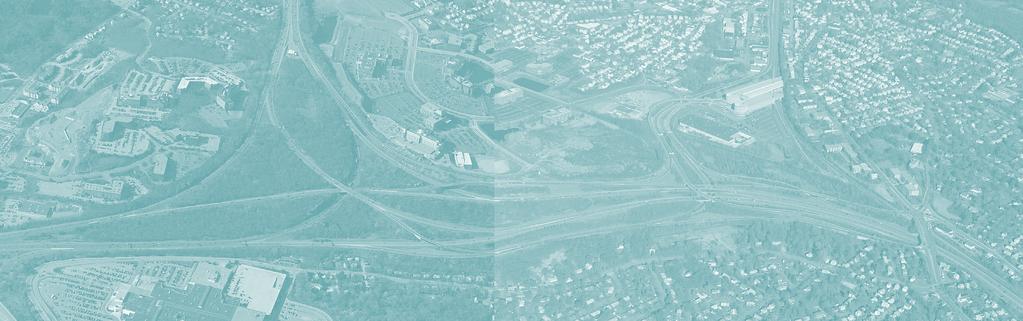
9 1 INTRODUCTION State legislators, South Shore Coalition members, and officials from South Shore communities requested that this study be included in the Boston Region MPO s fiscal year 2002 Unified Planning Work Program. In their letter to the Boston Region MPO, proponents of this study expressed concern about safety, congestion, and delays in the Braintree split, especially their effects on Route 3 South in that vicinity. As shown in Figure 1, the Braintree split is essentially the network of ramps and highway segments that comprise I-, the Southeast Expressway, and Route 3 South. To the southeast of the split, interchanges 18 (Washington Street) and 19 (Burgin Parkway) with their associated lane drops and weaving, merging, and diverging maneuvers add to the complexity of the main interchange. Immediately to the southwest of the split is I- interchange 6 (Route 37). Just north of the split is the southern terminus of the Southeast Expressway HOV lane and less than one-half mile north of that is I- interchange 8 (Furnace Brook Parkway). N Interchange 8, I-/Furnace Brook Pkwy. FIGURE 1 Braintree Split Study Area 37 Interchange 19, Route 3/Burgin Pkwy. Interchange 18, Route 3/ Washington St. During an average weekday, the Braintree split carries between 250,000 and 275,000 vehicles on six two-lane direct connections that connect the three major highways: I-, the Southeast Expressway, and Route 3 South. In short, the Braintree split is an interchange that was designed for high-level connections (flyovers). It carries more than a quarter of a million vehicles a day, whose drivers encounter a complex driving environment. Therefore, congestion and incidents are common, especially in the northbound direction in the morning and, to a lesser degree, in the southbound direction in the afternoon. 28 Interchange 6, I-/Granite St. 37 Braintree split 3 Field reconnaissance indicates that there are safety problems created by some of the merging and weaving traffic operations at the Braintree split. Field reconnaissance also indicates that some of the delays encountered at the split are due to bottlenecks located outside of the split. Interchange 17, Route 3/Union St. The report is organized into nine sections: an executive summary and eight chapters. Chapter 1 gives the background of the study. Chapter 2 documents the study area s traffic concerns. Chapter 3 describes the existing highway and transit conditions. Chapter 4 presents the socioeconomic trends and growth impacts in the study area. Chapter 5 explains the travel patterns of commuting trips to the Boston urban core. Chapter 6 presents the planned and proposed projects in the study area. Chapter 7 describes the improvements that are recommended in this study. Chapter 8 gives the process by which proposed transportation improvements may be implemented Note: The area in the circle is the study area for which design and operational improvements were developed and tested. However, the model sets that were developed for this purpose expand beyond I- exit 6, I- exit 8, and Route 3 exit 15 in order to capture the effects of congested locations upstream and downstream of the Braintree split. 7

10 2 INVENTORY OF TRAFFIC PROBLEMS Through meetings with the Advisory Task Force and field reconnaissance, CTPS developed an inventory of traffic problems in the study area and its vicinity. They include, but are not limited to, the following safety and operational problems listed below and shown in detail in Figures 2 and 3. Traffic congestion Downstream traffic bottlenecks High traffic demands Weaving and merging Short sight distance Traffic signal capacity issues Access to transit service These problems were grouped into two categories: external and internal. The internal problems are those that exist within the split and affect its traffic and safety operations. The external problems are those that exist outside of the Braintree split but have a major impact on its traffic and safety operations. The numbers in the circles and the text in the boxes in Figures 2 and 3 represent specific locations and identify the particular problem at each location. FIGURE 2 Braintree Split: Internal Problems N Congestion, Weaving, Merging, and Diverging High PM peak period southbound traffic volume on the Expressway merging with traffic entering from Furnace Brook Parkway/Willard Street and from the HOV lane, combined with the weaving associated with the split of the southbound traffic to I- and Route 3 South, causes backups on the Expressway to Granite Avenue and beyond. Weaving and Merging 5 On-ramp traffic from Furnace Brook Parkway and from the HOV lane has difficulty entering the main travel lanes because of PM peak period congestion. Congestion On-ramp traffic from Burgin Parkway and Washington Street has difficulty entering the HOV lane during the AM peak period because of a short weaving section involving crossing all four travel lanes with high traffic volumes on the Expressway. Similarly, Route 3 South bus traffic has difficulty entering the HOVlane. The Burgin Parkway/Centre Street traffic signal is unable to handle its traffic demands because of the high AM peak period traffic volumes from Burgin Parkway and the connector ramps. The northbound left-turn traffic to the Crown Colony Office Park causes a traffic queue that backs up onto Route 3 South and the connector ramp from Washington Street. Short Sight Distance Horizontal curvature of the connector from the Expressway to Route 3 South limits the sight distance for reacting to the PM peak period traffic queue on the Route 3 South connector INTERNAL PROBLEMS The internal problems are the weaving, merging, diverging, short sight distance, insufficient intersection capacity, and lane drops. Many of the AM peak-travel period internal problems show up during the PM peak travel period too, such as problems at locations #1, #2, #8, and #9. On the other hand, there are internal concerns that are confined either to the AM or PM peak period, for example, the problems at locations #3, #4, #5, #6, and #7. Field reconnaissance indicates that some of the merging and weaving traffic operations at the Braintree split create safety problems such as short weave sections for Route 37 northbound on-ramp traffic proceeding to the Southeast Expressway and for Washington Street northbound on-ramp traffic proceeding to the HOV lane. Also, the PM peak-period southbound merging traffic from the Furnace Brook Parkway on-ramp and the HOV exit, and diverging traffic from the Southeast Expressway onto Route 3 South create traffic congestion on the Expressway that extends into the Granite Avenue and Neponset River areas. 8 3 Short Deceleration Lane Traffic from Route 3 South has difficulty exiting onto Route 37 during peak periods because of high traffic volumes and a short deceleration lane Lane Drop and Merging 3 Downstream congestion on I- southbound and a lane drop at the merge point of the ramps from Route 3 South and Burgin Parkway cause traffic to back up onto both Route 3 South and Burgin Parkway during the PM peak period. Lane Drop and Merging 37 Short Weave Section Route 37 on-ramp traffic has difficulty proceeding to the Expressway because of a short weaving section involving crossing over two travel lanes where high traffic volumes diverge between vehicles going to the Expressway and vehicles going to Route 3 South. This problem occurs during the AM and PM peak periods. High PM peak period traffic volumes from Burgin Parkway (especially from the Crown Colony Office Park and the Quincy Adams MBTA Station) merging with southbound Route 3 South traffic causes backups on the connector ramps that lead to both the Expressway and I- (from Route 128). Also, the lane drop from two lanes to one on the ramp from I- (from Route 128) to Route 3 South before the merge with traffic from the Southeast Expressway contributes to the backups on I-.

11 2.2 EXTERNAL PROBLEMS Downstream traffic bottlenecks are the external problems that have major impacts on the Braintree split traffic operations in both peak travel periods (Figure 3). All three major highways of the split have bottlenecks. In the morning, downstream bottlenecks on the Expressway created by the northbound on-ramp traffic from Granite Avenue, Route 3A, Columbia Road, and the HOV merge restrict northbound traffic flow on the Expressway. On some occasions, this causes the traffic queue to back up into the Braintree split, restricting traffic flow from Route 3 South and I-. Another external problem is traffic operations at the Union Street rotary interchange on Route 3 South in Braintree. The high traffic volume on the ramp heading northbound disrupts traffic flow on Route 3 South in the AM peak travel period, which, in conjunction with similar activities at the Route 18 and Derby Street interchanges, causes recurring traffic backups on Route 3 South that are unrelated to traffic operations in the Braintree split. Similarly, the high southbound traffic volumes exiting Route 3 South at Union Street in the PM peak travel period cause traffic to spill back onto Route 3 South, restricting traffic flow from the split and from I- northbound onto Route 3 South. Downstream Bottlenecks FIGURE 3 Braintree Split: External Problems 12 AM peak period downstream bottlenecks on the Expressway, principally at Granite Avenue and at the Route 3A on-ramp north of the Neponset River, restricts traffic entering the Expressway from I- (from Route 24) and Route 3 South traveling through the Braintree split N Also, the PM peak-period congestion on I- southbound toward Route 24 spills back into the split. On many occasions, this backup restricts traffic from the Expressway and Route 3 South entering I- southbound toward Route 24. The main causes of this congestion are the bottleneck at the entrance to Route 24 where two congested twolane ramps feed into three lanes on Route 24, and traffic diverging from I- onto Route Traffic Congestion and Access to Developments on Route 37 and Forbes Road High traffic volumes exit at the I- northbound off-ramp at Route 37 during the AM and PM peak periods with traffic queues sometimes extending onto the freeway. 9 The direct impact of the I- southbound PM peak-period congestion is reduced traffic flow through the split. In 1994, the Expressway was servicing 7,900 southbound vehicles per hour at the split during the PM peak hour, of which 4,100 continued on I- and 3,800 continued on Route 3 South. In 2003, this number decreased to 6,600 southbound vehicles per hour during the PM peak hour, of which 3,200 continued on I- and 3,400 continued on Route 3 South. As explained above, these traffic patterns were due to the increasing congestion on I- southbound traveling toward Route 24 in the PM peak period. 24 Downstream Bottleneck A downstream bottleneck on I- during the PM peak period, principally at the point where traffic diverges onto Route 24, restricts traffic flow through the split from the Expressway and Route 3 South. Downstream Bottlenecks Downstream bottlenecks on Route 3 South during the AM peak period, caused principally by traffic merging from the northbound ramps at Union Street, Route 18, and Derby Street, cause long traffic queues that affect operations. During the PM peak period, the high volume of traffic exiting at Union Street also causes backups that restrict traffic flow through the split. 9
MEMORANDUM. for HOV Monitoring on I-93 North and the Southeast Expressway, Boston Region MPO, November, 2011.
 MEMORANDUM Date: January 12, 2012 To: Congestion Management Process Files From: Seth Asante, Ryan Hicks, and Efi Pagitsas MPO Staff Re: Historical Trends: Travel Times and Vehicle Occupancy Levels for
Appendix 4.1 J. May 17, 2010 Memorandum from CTPS to the Inter Agency Coordinating Group
 Appendix 4.1 J May 17, 2010 Memorandum from CTPS to the Inter Agency Coordinating Group CTPS CENTRAL TRANSPORTATION PLANNING STAFF Staff to the Boston Region Metropolitan Planning Organization MEMORANDUM
5.1 Traffic and Transportation
 5.1 When it opens in 2009, the Bellevue Nickel Improvement Project will increase the number of vehicles able to travel through the study area, improve travel speeds, and improve safety by reducing the
6 HIGH-OCCUPANCY-VEHICLE (HOV) LANES AND TRAVEL DEMAND MANAGEMENT (TDM) PROGRAMS
 LANES AND TRAVEL DEMAND MANAGEMENT (TDM) PROGRAMS") 6 HIGH-OCCUPANCY-VEHICLE (HOV) LANES AND TRAVEL DEMAND MANAGEMENT (TDM) PROGRAMS Travel demand management (TDM) programs enable roadways, which have a fixed capacity, to accommodate more travelers without
6 HIGH-OCCUPANCY-VEHICLE (HOV) LANES AND TRAVEL DEMAND MANAGEMENT (TDM) PROGRAMS Travel demand management (TDM) programs enable roadways, which have a fixed capacity, to accommodate more travelers without
Memorandum. Roger Millar, Secretary of Transportation. Date: April 5, Interstate 90 Operations and Mercer Island Mobility
 Memorandum To: From: The Honorable Dow Constantine, King County Executive; The Honorable Ed Murray, City of Seattle Mayor; The Honorable Bruce Bassett, City of Mercer Island Mayor; The Honorable John Stokes,
A. CONCLUSIONS OF THE FGEIS
 Chapter 11: Traffic and Parking A. CONCLUSIONS OF THE FGEIS The FGEIS found that the Approved Plan will generate a substantial volume of vehicular and pedestrian activity, including an estimated 1,300
Research Report Agreement T4118, Task 24 HOV Action Plan HOV ACTION PLAN
 Research Report Agreement T4118, Task 24 HOV Action Plan HOV ACTION PLAN by John M. Ishimaru Senior Research Engineer Duane Wright Systems Analyst Programmer Mark E. Hallenbeck Director Jaime Kang Research
Lake Erie Commerce Center Traffic Analysis
 LOCATION: East of NYS Route 5 at Bayview Road Town of Hamburg Erie County, New York PREPARED BY: Wendel Companies 140 John James Audubon Parkway Suite 200 Amherst, New York 14228 January 2012 i ii Table
Interstate 90 and Mercer Island Mobility Study APRIL Commissioned by. Prepared by
 Interstate 90 and Mercer Island Mobility Study APRIL 2017 Commissioned by Prepared by Interstate 90 and Mercer Island Mobility Study Commissioned by: Sound Transit Prepared by: April 2017 Contents Section
2004 Congestion Management System Report
 Chapter 3: Roadways 3.3.2.5 Analysis: Bottlenecks and Congested Segments on ed-access Highways Much like arterial roadways, where bottlenecks and delays are usually found at signalized intersections (and
Section 106 Update Memo #1 Attachment D. Traffic Diversion & APE Expansion Methodology & Maps
 Section 106 Update Memo #1 Attachment D Traffic Diversion & APE Expansion Methodology & Maps I-65/I-70 North Split Interchange Reconstruction Project (Des. Nos. 1592385 & 1600808) Traffic Diversion and
HOV LANE PERFORMANCE MONITORING: 2000 REPORT EXECUTIVE SUMMARY
 Final Report Research Project Agreement No. T1803, Task 4 HOV Monitoring V HOV LANE PERFORMANCE MONITORING: 2000 REPORT EXECUTIVE SUMMARY by Jennifer Nee TRAC Research Engineer John Ishimaru TRAC Senior
1.2 Corridor History and Current Characteristics
 SECTION 1 Description and Background of Study Area 1.1 Introduction This preliminary engineering report was prepared for the Alaska Department of Transportation and Public Facilities (ADOT&PF). It is part
APPENDIX J MODIFICATIONS PERFORMED TO THE TOR
 APPENDIX J MODIFICATIONS PERFORMED TO THE TOR This appendix summarizes the modifications that were performed in years 2012 and 2017 to rectify calculation errors that were observed in the data presented
Texas Transportation Institute The Texas A&M University System College Station, Texas
 1. Report No. FHWA/TX-05/0-4434-P1 2. Government Accession No. 3. Recipient's Catalog No. 4. Title and Subtitle GUIDANCE FOR FUTURE DESIGN OF FREEWAYS WITH HIGH- OCCUPANCY VEHICLE (HOV) LANES BASED ON
Arlington County Board Meeting Project Briefing. October 20, 2015
 Arlington County Board Meeting Project Briefing October 20, 2015 Project Map 2 Project Context Only Interstate in the Country limited to HOV only traffic during rush hours Stoplight at the end of I-66
STUDY DESCRIPTION MEMORANDUM. DATE April 20, 2011
 DATE April 0, 0 TO FROM RE MEMORANDUM Congestion Management Program Files Ariel Godwin, CMP Manager Boston Region MPO Staff Limited-Access Highway Counts and Traffic Volumes, Summer 00 This memorandum
MEMORANDUM. Open Section Background. I-66 Open Section Study Area. VDOT Northern Virginia District. I-66 Project Team. Date: November 5, 2015
 MEMORANDUM To: VDOT Northern Virginia District From: I-66 Project Team Date: November 5, 2015 Subject: Open Section Background The purpose of this technical memorandum is to provide narrative and technical
CALIFORNIA HIGH-OCCUPANCY VEHICLE LANE DEGRADATION ACTION PLAN
 CALIFORNIA DEPARTMENT OF TRANSPORTATION CALIFORNIA HIGH-OCCUPANCY VEHICLE LANE DEGRADATION ACTION PLAN Prepared by Division of Traffic Operations Office of Traffic Management Submitted to Federal Highway
Word Count: 3,565 Number of Tables: 4 Number of Figures: 6 Number of Photographs: 0. Word Limit: 7,500 Tables/Figures Word Count = 2,250
 Katherine F. Turnbull, Ken Buckeye, Nick Thompson 1 Corresponding Author Katherine F. Turnbull Executive Associate Director Texas Transportation Institute Texas A&M University System 3135 TAMU College
DISTRICT EXPRESS LANES ANNUAL REPORT FISCAL YEAR 2017 JULY 1, 2016 JUNE 30, FloridaExpressLanes.com
 DISTRICT EXPRESS LANES ANNUAL REPORT FISCAL YEAR 2017 JULY 1, 2016 JUNE 30, 2017 FloridaExpressLanes.com This page intentionally left blank. TABLE OF CONTENTS List of Figures... ii List of Tables.... ii
12, 14 and 16 York Street - Amendments to Section 16 Agreement and Road Closure Authorization
 REPORT FOR ACTION 12, 14 and 16 York Street - Amendments to Section 16 Agreement and Road Closure Authorization Date: April 27, 2018 To: Toronto and East York Community Council From: Senior Strategic Director,
MEMORANDUM. Lynn Hayes LSA Associates, Inc.
 MEMORANDUM To: Lynn Hayes LSA Associates, Inc. Date: May 5, 217 From: Zawwar Saiyed, P.E., Senior Transportation Engineer Justin Tucker, Transportation Engineer I Linscott, Law & Greenspan, Engineers LLG
EXISTING CONDITIONS A. INTRODUCTION. Route 107 Corridor Study Report
 II. EXISTING CONDITIONS A. INTRODUCTION The Route 107 study area extends from the south at Chestnut Street in Lynn approximately 3.7 miles to the north to Boston Street in Salem. The study area has three
Memorandum. Fund Allocation Fund Programming Policy/Legislation Plan/Study Capital Project Oversight/Delivery Budget/Finance Contract/Agreement Other:
 Memorandum Date: March 23, 2018 To: Transportation Authority Board From: Eric Cordoba Deputy Director Capital Projects Subject: 4/10/18 Board Meeting: San Francisco Freeway Corridor Management Study Update
CONGESTION REPORT 1 st Quarter 2018
 CONGESTION REPORT 1 st Quarter 2018 A quarterly update of the National Capital Region s traffic congestion, travel time reliability, top-10 bottlenecks and featured spotlight Feburary 11, 2019 ABOUT TPB
10.0 Recommendations Methodology Assumptions
 10.0 Recommendations To accommodate the projected growth of the I-526 corridor, this report has summarized potential improvement strategies that were separated into four categories, TDM, Modal, Traffic
Pedestrian Safety Review Spadina Avenue
 STAFF REPORT ACTION REQUIRED Pedestrian Safety Review Spadina Avenue Date: October 13, 2015 To: Toronto and East York Community Council From: Director, Transportation Services, Toronto and East York District
Update on the I-680 Transit Corridor Improvement Project HOV on/off Ramps Environmental Impact Report Community Engagement Plan
 Update on the I-680 Transit Corridor Improvement Project HOV on/off Ramps Environmental Impact Report Community Engagement Plan Presentation Overview Introductions Susan Miller, Director of Projects, Contra
B. Congestion Trends. Congestion Trends
 B. Congestion Trends Congestion Trends There are two types of congestion that impact mobility: recurring and non-recurring congestion. Recurring congestion is related to segments of roadway that are over
Score. Category. Access Aesthetics Community Resources
 NO BUILD ALTERNATIVE The No Build Alternative is the do nothing option that is used for comparison to the build alternatives. The screening assumes no new facilities are constructed as part of the I-93
Route 29 Solutions Projects
 Your guide to the Route 29 Solutions Projects For full details & continued engagement please visit www.route29solutions.org The Route 29 Solutions Package is a $230 million investment into the improvement
McLean Citizens Association Transportation Committee Project Briefing
 McLean Citizens Association Transportation Committee Project Briefing November 10, 2015 Project Map 2 Project Context Only Interstate in the Country limited to HOV only traffic during rush hours Stoplight
Planning. Proposed Development at the Southeast Corner of Lakeshore Road West and Brookfield Road Intersection FINAL.
 Project No. 121-22908 N o v e m b e r 2 0 1 2 Traffic Impact Study Transportation Planning th GENIVAR Inc., 600 Cochrane Drive, 5 Floor, Markham, Ontario L3R 5K3 Telephone: 905.475.7270 Fax: 905.475.5994
HDR itrans Consulting Inc. 100 York Blvd., Suite 300 Richmond Hill, ON L4B 1J8 Tel: (905) Fax: (905)
 Fax: (905)") !" # $ !" # $ Consulting Inc. 100 York Blvd., Suite 300 Richmond Hill, ON L4B 1J8 Tel: (905) 882-4100 Fax: (905) 882-1557 www.itransconsulting.com November 2009 %&'('$&$ 1. West Brampton Road Network...
!" # $ !" # $ Consulting Inc. 100 York Blvd., Suite 300 Richmond Hill, ON L4B 1J8 Tel: (905) 882-4100 Fax: (905) 882-1557 www.itransconsulting.com November 2009 %&'('$&$ 1. West Brampton Road Network...
Frequently Asked Questions on the Route 29 Solutions Improvements Projects
 Frequently Asked Questions on the Route 29 Solutions Improvements Projects Background What are the Route 29 Solutions improvement projects? These projects include the Route 29/250 Interchange ( Best Buy
Treasure Island Supplemental Information Report Addendum
 1 1 1 1 0 1 0 1 0 1 Treasure Island Supplemental Information Report Addendum Introduction Purpose The purpose of this Supplemental Information Report (SIR) Addendum is to determine if the current land
I-66 Inside the Beltway Feasibility Study
 I-66 Inside the Beltway Feasibility Study Feasibility Study Study Process Context Sensitive Dialogues Corridor Assessments / Data Collection Problem Statement Refinement Concept Development Concept Evaluation
INTERSTATE 395 EXPRESS LANES NORTHERN EXTENSION TRAFFIC & TRANSPORTATION TECHNICAL REPORT SEPTEMBER 2016
 INTERSTATE 395 EXPRESS LANES NORTHERN EXTENSION TRAFFIC & TRANSPORTATION TECHNICAL REPORT SEPTEMBER 2016 INTERSTATE 395 EXPRESS LANES NORTHERN EXTENSION Traffic and Transportation Technical Report City
CRISIS COALITION. Regional Projects Analysis February 2, 2015
 CRISIS COALITION Regional Projects Analysis February 2, 215 STUDY BACKGROUND Team of CRISIS Representatives, Parish Presidents and/or their Representatives, Legislators, and MPO Staff shortlisted 19 regional
Assessment of Travel Trends
 I - 2 0 E A S T T R A N S I T I N I T I A T I V E Assessment of Travel Trends Prepared for: Metropolitan Atlanta Rapid Transit Authority Prepared by: AECOM/JJG Joint Venture Atlanta, GA October 2011 General
I-75 in Hamilton County Project Termini
 I-75 in Hamilton County Project Termini Introduction As part of the North South Transportation Initiative (NSTI), capacity improvements were recommended for the I-75 corridor through Hamilton County from
Appendix 4.8 A. Agency Correspondence and Final APE Statement
 Appendix 4.8 A Agency Correspondence and Final APE Statement Area of Potential Effect for Cultural Resources Introduction The South Coast Rail project requires review by the Army Corps of Engineers (Corps),
user s guide to Transportation Improvements in Astoria Planning Efforts outside Astoria for more information, contact:
 The Miles Crossing/ Jeffers Garden transportation plan (underway), will identify needed improvements to the Warrenton Astoria Highway and local street improvements to serve expected growth in the Miles
State aims to cure accident-plagued South Jersey interchange
 State aims to cure accident-plagued South Jersey interchange 11:52 PM, Apr. 16, 2011 Written by JOE COONEY, Courier-Post Staff GLOUCESTER CITY Anyone who has driven the gantlet known as the I-295/I- 76/Route
Arlington County Board Work Session Eastbound Widening January 17, Amanda Baxter, VDOT Special Projects Development Manager
 Arlington County Board Work Session Eastbound Widening January 17, 2017 Amanda Baxter, VDOT Special Projects Development Manager Program Area Map 2 Program Scope Tolling during weekdays, peak hours, peak
APPENDIX H MILESTONE 2 TRAFFIC OPERATIONS ANALYSIS OF THE AT-GRADE CROSSINGS
 Draft Environmental Impact Statement/Environment Impact Report Appendix H Milestone 2 Traffic Operations Analysis of the At-Grade Crossings APPENDIX H MILESTONE 2 TRAFFIC OPERATIONS ANALYSIS OF THE AT-GRADE
Construction underway. STATUS: 229 5,190 5,419 5,305 STIP REFERENCE #FR /01/2013
 FREDERICK COUNTY STATE HIGHWAY ADMINISTRATION -- Frederick County -- Line 1 PROJECT: I-7, Baltimore National Pike INTERSTATE CONSTRUCTION PROGRAM DESCRIPTION: Widen I-7 east of MD 355 to east of MD 144
AGENDA ITEM I-6 Public Works
 AGENDA ITEM I-6 Public Works STAFF REPORT City Council Meeting Date: 8/6/2018 Staff Report Number: 18-150-CC Informational Item: Update on the Willow Road and highway 101 interchange construction, upcoming
Northern Virginia District State of the District. Helen L. Cuervo, P.E. District Engineer October 18, 2017
 Northern Virginia District State of the District Helen L. Cuervo, P.E. District Engineer October 18, 2017 Susan Shaw, P.E., Megaprojects Director Virginia Department of Transportation American Society
What We ve Learned About Highway Congestion
 What We ve Learned About Highway Congestion BY PRAVIN VARAIYA THERE ARE 26,000 SENSORS buried under the pavements of California freeways. Every thirty seconds, those sensors send data to our computers
MARSHALL Subdivision. Township of Springwater, County of Simcoe. Traffic Brief for: Ontario Inc. Type of Document: Final Report
 MARSHALL Subdivision Township of Springwater, County of Simcoe Traffic Brief for: 489469 Ontario Inc. Type of Document: Final Report Project Number: JDE 1521 Date Submitted: October 19 th, 2016 10 / 19
Non-Motorized Transportation
 Non-Motorized Transportation Non-motorized facilities are important components to the transportation system. They provide an environmentally-friendly, low-cost mode of travel. Some of the facilities can
SANTA CLARA COUNTY I-280 CORRIDOR STUDY
 SANTA CLARA COUNTY I-280 CORRIDOR STUDY Appendix B 2 Technical Memorandum Existing Transportation Condition Memo SANTA CLARA VALLEY TRANSPORTATION AUTHORITY (VTA) 1-1 Introduction The I-280 Corridor Study
7272 WISCONSIN AVENUE LOCAL AREA TRANSPORTATION REVIEW
 7272 LOCAL AREA TRANSPORTATION REVIEW AND TRANSPORTATION POLICY AREA REVIEW MONTGOMERY COUNTY, MARYLAND Submitted on behalf of Carr Properties Prepared by: Wells + Associates, Inc. Submission: July 1,
2008 DEKALB COUNTY TRANSPORTATION PLAN (UPDATE)
") 2008 DEKALB COUNTY TRANSPORTATION PLAN (UPDATE) TABLE OF CONTENTS Introduction 1 Transportation Planning Activities 2 Identification of Problem Areas and Recommended Solutions 7 DeKalb County Projects
2008 DEKALB COUNTY TRANSPORTATION PLAN (UPDATE) TABLE OF CONTENTS Introduction 1 Transportation Planning Activities 2 Identification of Problem Areas and Recommended Solutions 7 DeKalb County Projects
I-405 Express Toll Lanes Coming in 2015
 I-405 Express Toll Lanes Coming in 2015 Jennifer Charlebois Roadway Toll Systems PE, Toll Division Anne Broache Public Information, I-405/SR 167 Lynn Peterson Secretary of Transportation Market Neighborhood
BOSTON REGION METROPOLITAN PLANNING ORGANIZATION
 PLANNING ORGANIZATIO BOSTON REGION MPO NMETROPOLITAN BOSTON REGION METROPOLITAN PLANNING ORGANIZATION Stephanie Pollack, MassDOT Secretary and CEO and MPO Chair Karl H. Quackenbush, Executive Director,
Role of High-Occupancy-Vehicle Lanes Highway Construction Management
 TRANSPORTATION RESEARCH RECORD 1280 131 Role of High-Occupancy-Vehicle Lanes Highway Construction Management In ALLAN E. PINT, CHARLEEN A. ZIMMER, AND FRANCIS E. LOETTERLE The Minnesota Department of Transportation
Imagine the result. Bus Rapid Transit Feasibility Study. Laredo Urban Transportation Study. August 31 st, 2011
 Imagine the result Laredo Urban Transportation Study August 31 st, 2011 Bus Rapid Transit Feasibility Study Prepared for: Laredo Urban Transportation Study Prepared by: ARCADIS U.S., Inc. 2410 Paces Ferry
Site Location and Setting
 Memorandum Date: To: From: Subject: Kristy Le, Gary Black Steve Orem Santa Teresa County Park Historic Area Traffic and Parking Study Hexagon Transportation Consultants, Inc. has completed a traffic and
Memorandum. To: From: cc: Date: November 7, Re: 1.0 Purpose and Organization of this Addendum. 2.0 Project Description
 Memorandum To: From: cc: Laura Prickett, Horizon Water and Environment Analette Ochoa and Wana Chiu, WRECO Parag Mehta, Kimley Horn Date: November 7, 2017 Re: Santa Cruz Route 1 Tier I and Tier II HOV
rtc transit Before and After Studies for RTC Transit Boulder highway UPWP TASK Before Conditions
 rtc transit Before and After Studies for RTC Transit UPWP TASK 3403-11-14 Before Conditions Report Boulder highway June 2011 Before and After Studies for RTC Transit BOULDER HIGHWAY BEFORE STUDY UPWP Task
FEASIBILITY STUDY REFINED CONCEPT 1 PROJECT A
 VIRGINIA DEPARTMENT OF TRANSPORTATION I-85 / I-95 INTERCHANGE FEASIBILITY STUDY REFINED CONCEPT 1 PROJECT A Columbia Rd REFINED CONCEPT 1 PROJECT A Bellevue Rd COST: $3.3M Siege Rd Eliminate the loop ramp
Fairfax County Parkway Widening Fairfax County
 Get Involved VDOT representatives will review and evaluate information received as a result of this meeting. Please fill out the comment sheet provided in this brochure if you have any comments or questions.
Project Deliverable 4.1.3d Individual City Report - City of La Verne
 Pomona Valley ITS Project Project Deliverable 4.1.3d Individual City Report - City of La Verne Prepared by: April 19, 2002 099017000.1 Copyright 2002, Kimley-Horn and Associates, Inc TABLE OF CONTENTS
TABLE OF CONTENTS. Coral Springs Charter High School and Middle School Job No Page 2
 Job No. 15-019 Page 2 TABLE OF CONTENTS 1.0 INTRODUCTION... 4 2.0 EXISTING CONDITIONS... 5 3.0 TRAFFIC GENERATION... 7 4.0 TRIP DISTRIBUTION... 8 5.0 FUTURE CONDITIONS... 8 6.0 SITE ACCESS...13 7.0 CONCLUSION...13
Westover Metropolitan Airport Master Plan Update
 Westover Metropolitan Airport Master Plan Update June 2008 INTRODUCTION Westover Metropolitan Airport (CEF) comprises the civilian portion of a joint-use facility located in Chicopee, Massachusetts. The
NCUTCD Proposal for Changes to the Manual on Uniform Traffic Control Devices
 1 2 3 4 5 6 7 8 9 10 11 12 13 14 15 16 17 18 19 20 21 22 23 24 25 26 27 28 29 30 31 32 TECHNICAL COMMITTEE: ITEM NUMBER: TOPIC: ORIGIN OF REQUEST: AFFECTED SECTIONS OF MUTCD: NCUTCD Proposal for Changes
Proposed Bicycle Lanes on Yonge Street from Queens Quay to Front Street
 STAFF REPORT ACTION REQUIRED Proposed Bicycle Lanes on Yonge Street from Queens Quay to Front Street Date: March 12, 2007 To: From: Toronto and East York Community Council Director, Transportation Infrastructure
Minutes of the Third Meeting THE WASHINGTON COUNTY TRANSIT DEVELOPMENT PLAN ADVISORY COMMITTEE
 Minutes of the Third Meeting THE WASHINGTON COUNTY TRANSIT DEVELOPMENT PLAN ADVISORY COMMITTEE Date: May 8, 2013 Time: 9:30 a.m. Place: Conference Room 249 Washington Highway Department 900 Lang Street
Elected Officials and Media Briefing I-395 Express Lanes Northern Extension
 Elected Officials and Media Briefing I-395 Express Lanes Northern Extension Updates on: I-95 Express Lanes Southern Extension Transform 66: Inside and Outside the Beltway March 31, 2016 Today s Agenda
PDF compression, OCR, web optimization using a watermarked evaluation copy of CVISION PDFCompressor
 o U.S. Department Washington Division Suite 501 Evergreen Plaza of Transportation 711 South Capitol Way Olympia, Washington 98501-1284 Federa' Highway (360) 753-9480 Administration (360) 753-9889 (FAX)
Basic Project Information
 FY 2015-16 PROJECT DESCRIPTION FORM (2C) Submitting Agency: Loudoun County Basic Project Information Project Title: Loudoun County Parkway (VA Route 607) U.S. 50 to Creighton Rd. (2C) Project Type (check
TRANSPORTATION ELEMENT
 Transportation TRANSPORTATION ELEMENT Data, Inventory, and Analysis Prepared by Contents 1.0 INTRODUCTION... 1 2.0 EXISTING CONDITIONS... 1 2.1 Roadways... 1 2.1.1 Jurisdiction... 1 2.1.2 Functional Classification...
I-95/395 HOV/Bus/HOT Lanes Project Overview
 I-95/395 HOV/Bus/HOT Lanes Project Overview 2 I-95/395 HOV/Bus/HOT Lanes Meetings Agenda 7 p.m. to 9 p.m. Open House Information Stations and Q&A With Project Staff 7:30 p.m. and 8:30 p.m. Project Overview
FNORTHWEST ARKANSAS WESTERN BELTWAY FEASIBILITY STUDY
 FNORTHWEST ARKANSAS WESTERN BELTWAY FEASIBILITY STUDY EXECUTIVE SUMMARY The 2030 Northwest Arkansas Regional Transportation Plan developed by the Northwest Arkansas Regional Planning Commission (NWARPC)
PURPOSE AND NEED (CONCURRENCE POINT 1) NEW CANADA ROAD PROJECT FROM STATE ROUTE 1 (U.S. HIGHWAY 70) TO U.S. INTERSTATE 40
 NEW CANADA ROAD PROJECT FROM STATE ROUTE 1 (U.S. HIGHWAY 70) TO U.S. INTERSTATE 40") PURPOSE AND NEED (CONCURRENCE POINT 1) NEW CANADA ROAD PROJECT FROM STATE ROUTE 1 (U.S. HIGHWAY 70) TO U.S. INTERSTATE 40 Project Description The primary purpose of this project is to improve the major
PURPOSE AND NEED (CONCURRENCE POINT 1) NEW CANADA ROAD PROJECT FROM STATE ROUTE 1 (U.S. HIGHWAY 70) TO U.S. INTERSTATE 40 Project Description The primary purpose of this project is to improve the major
4. Safety Concerns Potential Short and Medium-Term Improvements
 NH Route 104 Access Management Study Page 19 4. Safety Concerns Potential Short and Medium-Term Improvements Potential safety improvement strategies are listed by priority based on field observations by
Public Meeting: Metropolitan Washington Airports Authority (MWAA) Transportation Network Company (TNC) Lot on S. Eads Street
 Transportation Network Company (TNC) Lot on S. Eads Street") Public Meeting: Metropolitan Washington Airports Authority (MWAA) Transportation Network Company (TNC) Lot on S. Eads Street Arlington County Department of Environmental Services Transportation Division
Public Meeting: Metropolitan Washington Airports Authority (MWAA) Transportation Network Company (TNC) Lot on S. Eads Street Arlington County Department of Environmental Services Transportation Division
CUMULATIVE GROWTH INDUCEMENT STUDY for the Highway 1 Corridor
 CUMULATIVE GROWTH INDUCEMENT STUDY for the Highway 1 Corridor From San Andreas-Larkin Valley Roads to Morrissey Boulevard 05-SCR-1, PM R733 (KP 11.79) 7.6 to PM 16.13 (KP 25.96) Santa Cruz County, California
A VISION FOR I-95. January 12, Delaware Department of Transportation
 A VISION FOR I-95 January 12, 2011 Delaware Department of Transportation The East Coast s Main Street Along with SR 1, the most significant highway in Delaware 29 miles to I ".', 2 Sponsoring / Cooperating
Launceston City Council. Kings Meadows Traffic Management Report for Public Consultation
 Launceston City Council Kings Meadows Traffic Management Report for Public Consultation November 2013 This report: has been prepared by GHD for Launceston City Council and may only be used and relied on
FHWA P/N Guidelines. Corridor Relationship. Highway 22 Segment 1 - US 169 to CSAH 2 Relevance / Documentation of Need
 Highway 22 Segment 1 - US 169 to CSAH 2 Vehicle Mobility Congestion Intersection Congestion Existing Conditions - Based on Highway Capacity Manual methodology, corridor level of service is currently LOS
UNION STATION ACCESS AND CAPACITY IMPROVEMENT STUDY PROJECT REPORT
 UNION STATION ACCESS AND CAPACITY IMPROVEMENT STUDY PROJECT REPORT Washington Metropolitan Area Transit Authority Department of Planning and Joint Development In Association with District of Columbia Department
TRAFFIC IMPACT STUDY REPORT FOR PROPOSED OFFICE PROJECT AT 959 SEWARD STREET IN HOLLYWOOD SNYDER PARTNERS
 DRAFT TRAFFIC IMPACT STUDY REPORT FOR PROPOSED OFFICE PROJECT AT 959 SEWARD STREET IN HOLLYWOOD Prepared for: SNYDER PARTNERS Prepared by: Crain & Associates 2007 Sawtelle Boulevard, Suite 4 Los Angeles,
Freeway Volume-Crash Summary
 Freeway Volume-Crash Summary Twin Cities Metropolitan Area Continuation Report 22 Data Minnesota Department of Transportation Office of Traffic, Security and Operations Freeway Operations Section Regional
RACINE COUNTY PUBLIC TRANSIT PLAN:
 RACINE COUNTY PUBLIC TRANSIT PLAN: 2013-2017 Recommended Transit Service Improvement Plan NEWSLETTER 3 SEPTEMBER 2013 This newsletter describes the final recommended public transit plan for the City of
University Region Non-Motorized Plan 2015
 Non-Motorized Transportation Non-motorized facilities are important components to the transportation system. They provide an environmentally-friendly, low-cost mode of travel. Some of the facilities can
PREFACE. Service frequency; Hours of service; Service coverage; Passenger loading; Reliability, and Transit vs. auto travel time.
 PREFACE The Florida Department of Transportation (FDOT) has embarked upon a statewide evaluation of transit system performance. The outcome of this evaluation is a benchmark of transit performance that
KING STREET TRANSIT PILOT
 KING STREET TRANSIT PILOT Update toronto.ca/kingstreetpilot #kingstreetpilot HIGHLIGHTS TRANSIT RIDERSHIP TRANSIT CAPACITY To respond to this growth in ridership, the TTC has increased the capacity of
Business Growth (as of mid 2002)
") Page 1 of 6 Planning FHWA > HEP > Planning > Econ Dev < Previous Contents Next > Business Growth (as of mid 2002) Data from two business directories was used to analyze the change in the number of businesses
Page 1 of 6 Planning FHWA > HEP > Planning > Econ Dev < Previous Contents Next > Business Growth (as of mid 2002) Data from two business directories was used to analyze the change in the number of businesses
IMPACT OF NORTH-SOUTH TRAFFIC
 CIRCULATION ELEMENT WHITE PAPER NO. 4 IMPACT OF NORTH-SOUTH TRAFFIC INTRODUCTION Beverly Hills is not well served from a regional transportation accessibility standpoint. This is especially true in regard
1.0 Purpose and Organization of the Community Impact Assessment Addendum
 Memorandum To: From: cc: Laura Prickett, Horizon Water and Environment Carie Montero, Senior Project Manager/Environmental Lead, Parsons Transportation Group Parag Mehta, Kimley Horn Date: September 24,
TABLE OF CONTENTS. 1 P age
 TABLE OF CONTENTS PROJECT DESCRIPTION... 2 PROJECT LOCATION... 5 PROEJCT PARTIES... 8 GRANT FUNDS AND SOURCES/ USES OF PROJECT FUNDS... 8 PRIMARY SELECTION CRITERIA/ QUALITY OF LIFE... 9 RESULTS OF BENEFIT
Toronto 2015 Pan Am/Parapan Am Games Temporary Traffic By-law Amendments for High Occupancy Vehicle Lanes (Supplementary Report)
") STAFF REPORT ACTION REQUIRED Toronto 2015 Pan Am/Parapan Am Games Temporary Traffic By-law Amendments for High Occupancy Vehicle Lanes (Supplementary Report) Date: March 25, 2015 To: From: Wards: Reference
STAFF REPORT ACTION REQUIRED Toronto 2015 Pan Am/Parapan Am Games Temporary Traffic By-law Amendments for High Occupancy Vehicle Lanes (Supplementary Report) Date: March 25, 2015 To: From: Wards: Reference
TransAction Overview. Introduction. Vision. NVTA Jurisdictions
 Introduction Vision NVTA Jurisdictions In the 21 st century, Northern Virginia will develop and sustain a multimodal transportation system that enhances quality of life and supports economic growth. Investments
This page intentionally left blank
 This page intentionally left blank Prepared for: Nevada Department of Transportation Prepared by: July 2015 This page intentionally left blank Table of Contents Executive Summary... ES-1 ES.1. HOV System
Public Informational Meeting
 Public Informational Meeting April 17, 2007 Bow-Concord I-93 I Transportation Planning Study Bow-Concord Interstate 93 Transportation Planning Study Context Sensitive Solutions Planning Steps Screen Alternatives
Eleven things you should know about the carpool lanes in Los Angeles County.
 Eleven things you should know about the carpool lanes in Los Angeles County. Los Angeles County Metropolitan Transportation Authority One Gateway Plaza Los Angeles, CA 912 COMPANY NAME Street Address City,