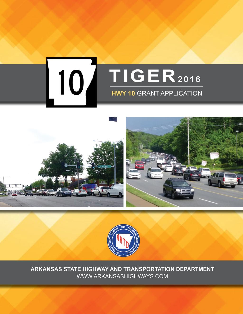
TABLE OF CONTENTS. 1 P age
|
|
|
- Herbert Patrick
- 6 years ago
- Views:
Transcription
1
2 TABLE OF CONTENTS PROJECT DESCRIPTION... 2 PROJECT LOCATION... 5 PROEJCT PARTIES... 8 GRANT FUNDS AND SOURCES/ USES OF PROJECT FUNDS... 8 PRIMARY SELECTION CRITERIA/ QUALITY OF LIFE... 9 RESULTS OF BENEFIT COST ANALYSIS PROJECT READINESS FEDERAL WAGE RATE CERTIFICATION P age


3 Project Description Well I left my job about 5 o'clock, it took fifteen minutes go three blocks, Just in time to stand in line with a freeway looking like a parking lot. Damn this traffic jam, how I hate to be late, it hurts my motor to go so slow. Damn this traffic jam, time I get home my supper'll be cold, damn this traffic jam. -James Taylor Highway 10 in west Little Rock, Arkansas, is the primary travel and commuting route for tens of thousands of people daily. Expansion of the city has slowly begun to move down Highway 10 to the west, steering people and the businesses that serve them towards this boundary of the city. One study by the Metropolitan Planning Organization for the Central Arkansas Regional Transportation Study (CARTS) identified the area as the third largest percentage of population change, ranging between a 75%-126% increase over the decade beginning in 2000 as shown in Figure 1. Due to retail developments such as the 11 acre, 315,000 square foot Pleasant Ridge Town Center, numerous multi-family dwellings and new public schools, the growth has began to take its toll on Highway 10. The route also remains a primary route for many out-oftown commuters making their way in to work in the central Little Rock area. Figure 1 Population Change 2 P age

4 Figure 2 Highway 10 Improvement Study Cover The importance of Highway 10 becomes even more apparent when you take into consideration the limited connectivity of the surrounding street network. Limited east-west routes coupled with local growth and rural commuters has contributed to the need for expansion of this important route. In 2013 a highway improvement study was conducted on approximately 8.3 miles of what was then, and remains now, the most highly congested principal arterial in the state of Arkansas. This portion of Highway 10, running west from Pleasant Valley Road to Ferndale Cutoff, lies almost completely within the western city limits for the City of Little Rock, Arkansas, and is one of only two National Highway System (NHS) routes south of the Arkansas River and west of Interstate 430 which services the largest metropolitan statistical area in the state. The study concluded that significant improvements throughout the corridor are necessary. Levels of service (LOS) during peak times are currently borderline adequate or, in places, inadequate with today s traffic. When traffic is projected to 2035, the LOS shows a substantial deterioration, with all segments reaching an unsatisfactory level. Traffic flows within the project area breakdown between Pleasant Ridge Road and Taylor Loop Road. (See Table 1, below). Table 1 Levels of Service at Signalized Intersections (No-Build) Project Area Highlighted Synchro Intersection AM PM AM PM Chenal Parkway C C E C The Divide Parkway B B B B Chenonceau Blvd. C A E B Ranch Blvd. B B B C Ranch Drive A B C C La Marche Drive B A D B Taylor Loop Road D C F F Pinnacle Valley Road D D D F Kroger Marketplace C C C D Sam Peck Road B C F F Pleasant Ridge Road E B F F Southridge Drive D B E F Pleasant Ridge Town Center B B F F Rodney Parham Road F F F F Interstate 430 NB C C F D 3 P age

. This work will include reconfiguration of the Interstate 430 and Highway 10 interchange.")
5 Based on the recommendations of the study, a plan was developed to implement the necessary changes. The study identified over $50 million worth of improvements in the first mile, between Pleasant Valley Road and Pleasant Ridge Road. As a demonstration of the Arkansas State Highway and Transportation Department s (AHTD) commitment to improve Highway 10, $58.3 million is included in the Statewide Transportation Improvement Program (STIP). This work will include reconfiguration of the Interstate 430 and Highway 10 interchange. Due to limited funding, the improvements programmed stop after the first mile, terminating at Pleasant Ridge Road, despite the pressing current and anticipated need for improvements farther west. While $58.3 million is substantial, it is not enough to address the needs of widening this corridor. This application seeks funding to extend the project an additional 2.13 miles west to the intersection of Highway 10 and Taylor Loop Road. Any awarded TIGER funds will be used to convert the existing five lane road to six lanes with a raised median and a reconfiguration of the Taylor Loop intersection. Figure 3 shows the existing 5 lane road. Figure 3 Highway 10 Project Area (Existing 5-Lane) 4 P age

6 Project Location To understand the issues plaguing the project area, it is necessary to have an understanding of where the project area lies in relation to the city of Little Rock and the surrounding area as shown below in Figure 4. Figure 4 Regional Area Highway 10 is an east-west highway between Little Rock and western Arkansas. Within the Little Rock metropolitan area, it is a principal arterial that provides access to the northern and western portions of Little Rock and Pulaski County. In recent years, Highway 10, within the urban boundary of Little Rock, has become a heavily developed urban corridor. It was widened in the 1990 s between Interstate 430 and Highway 300 from a two-lane highway to a four-lane highway with a continuous two-way, left turn lane. The 2013 Highway Improvement Study Area is shown in Figure 5 on the following page. 5 P age

7 Figure Highway Improvement Study Area Between Ferndale Cut-Off Road and Highway 300 Highway 10 between Ferndale Cut-Off Road and Highway 300 currently has two through lanes. A continuous, two-way left turn lane is also provided between Chalamont Drive and Highway 300. While this area is mostly rural, some suburban development has been initiated, and ample land is available for future development. In addition, Robinson Public Schools are located along Highway 10 between Chalamont Drive and Highway 300. Due to its location at the edge of the urbanized area, a high percentage of the trips on this part of Highway 10 are commuter trips. The characteristics of these trips consist of high peak directional volumes and relatively low volumes during the off peak periods. This produces poor operating conditions over relatively short time periods. Between Highway 300 and Taylor Loop Road Multiple office complexes and subdivisions have been constructed along this section in recent years. But, large amounts of land are still available for development. It is only a matter of time before this section develops into a urbanized area. Traffic volumes are relatively modest for a four-lane roadway, and the roadway currently operates with minimal congestion. 6 P age

8 Between Taylor Loop Road and Pleasant Valley Road (project area) This is the portion of Highway 10 that is included in this application for additional funding. Between Taylor Loop Road and Pleasant Ridge Road, there has been intense development over the past twenty years. However, land still exists for further development throughout the project area. This segment operates with a high level of congestion during both the morning and afternoon peak hours. Numerous traffic lights are needed to provide access for side street traffic. Congestion is most severe in the eastbound direction during both the morning and the afternoon peaks. This is due to the high volume of westbound vehicles turning left at several of the cross streets including, Rodney Parham Road, Pleasant Ridge Road, Sam Peck Road and Taylor Loop Road. This portion of the project area is outlined below in Figure 6. Figure 6 Project Location 7 P age
9 Project Parties The Arkansas State Highway and Transportation Department is the sole party seeking award of the grant benefits sought. Grant Funds and Sources/Uses of Project Funds The CARTS concurs on the need to improve Highway 10 between Pleasant Ridge Road and Taylor Loop Road. Designated by the Governor as the Metropolitan Planning Organization for this region, CARTS is responsible for the preparation of the CARTS Transportation Improvement Program (TIP) and the Metropolitan Transportation Plan. The TIP contains all short-term commitments for state and federal transportation funding in the metropolitan area. The TIP includes improvements for Highway 10 between Pleasant Ridge Road and Taylor Loop Road. AHTD is requesting $42.0 million in TIGER 2016 funds for this project. AHTD has dedicated $10.5 million of state funds to match the TIGER funds. Project Funding Sources and Project Funding Activities are shown in Tables 2 and 3 below. Table 2 Project Funding Sources SOURCES COSTS FUNDING PERCENT STATUS TIGER 2016 Funds $42.0 Applied For 80% State $10.5 Committed 20% TOTAL PROJECT FUNDS $ % Table 3 Project Funding Activities ACTIVITITES COSTS Construction $26.9 Right-of-way $10.8 Utilities $9.2 PE $2.9 CENG $2.7 TOTAL PROJECT FUNDS $ P age

10 Primary Selection Criteria/ Quality of Life The project seeks to make a huge difference in the quality of life for the residents of Central Arkansas. The primary vehicle for this difference will be increased capacity, with corresponding reduced congestion, which is ultimately the overarching goal of the project. In addition to the benefits that come from reduced congestion, other features will be incorporated that will increase the effectiveness of local access; will increase connectedness of vibrant retail districts; and set the groundwork for future and continued implementation of pedestrian and bicycle connectivity within the local community. An example of project area improvements are shown in Figure 7. Figure 7 Example of Project Area Improvements Traffic Congestion Perhaps no element of highway transportation has as great an impact on individual well-being and quality of life as the issue of congestion. These are well documented in any number of studies and reports from the well-known annual Urban Mobility Report of the Texas A&M Transportation Institute to what are seemingly monthly studies showing adverse effects from congestion. Increased commute lengths from congestion have surprisingly negative impacts. The A&M study showed that Cities of all sizes are experiencing the challenges seen before the start of the recession increased traffic congestion resulting from growing urban populations and lower fuel prices are outpacing the nation s ability to build infrastructure. 9 P age
11 The report predicts urban roadway congestion will continue to get worse without more assertive approaches on the project, program, and policy fronts. By 2020, with a continued good economy: Annual delay per commuter will grow from 42 hours to 47 hours. Total delay nationwide will grow from 6.9 billion hours to 8.3 billion hours. The total cost of congestion will jump from $160 billion to $192 billion. A 2011 study published in the journal BMC Public Health found that commute lengths have adverse physical health costs, with the primary ill-effects being poor sleep quality, exhaustion, and low general health. Stress was understandably apparent as well. Traffic congestion also has an increasingly negative impact upon the quality of life of families. In a 2005 survey, for example, 52% of Northern Virginia commuters reported that their travel times to work had increased in the past year, leading 70% of working parents to report having insufficient time to spend with their children and 63% of respondents to report having insufficient time to spend with their spouses. The list could go on and on, from time estimates lost (38 hours per year nationally, on average) to lack of reliability resulting in an inability to know how long a regular trip will take. The project will address the most congested primary arterial in the state, and analyses performed show significant improvement to congestion, and hence congestion related quality of life issues, as a result of the recommended improvements. Those improvements include a six-lane section with a raised median or a continuous, two-way, center left turn lane. The six-lane section should extend far enough west of Taylor Loop Road to allow full utilization of all lanes at the Taylor Loop Road intersection. The following intersection improvements (Figure 8) are proposed on Highway 10 east of Taylor Loop Road: Maintain the existing eastbound right turn lane (in addition to six through lanes) at Taylor Loop Road. Construct a westbound dual left turn lane at Taylor Loop Road. Maintain the existing eastbound right turn lane (in addition to six through lanes) at Sam Peck Road. Maintain the existing eastbound right turn lane (in addition to six through lanes) at Pleasant Ridge Road Provide parallel left turn lanes to accommodate westbound left turns at Pleasant Ridge Road and eastbound left turns at Southridge Drive. Stripe the center lane of the northbound approach of Pleasant Ridge Road to accommodate both left turn and through movements. 10 P age

12 Figure 8 Improvement Segments As is shown in Table 4, the proposed improvements greatly improved traffic conditions between Taylor Loop Road and Pleasant Ridge Road, both in the present year and in The analysis allows for a reasonable amount of growth throughout the area over the next twenty years but does not account for an unusually high amount of new traffic at any single intersection. Table 4 Levels of Service at Signalized Intersections, Project Area Highlighted No-Build Improve Highway Intersection AM PM AM PM AM PM AM PM Taylor Loop Road D C F F B B C C Pinnacle Valley Road D D D F A A A C Kroger Marketplace C C C D A B A C Sam Peck Road B C F F B B B C Pleasant Ridge Road E B F F B B B B Southridge Drive D B E F A A B B Pleasant Ridge Shopping Center B B F F A A D B While a raised median and a continuous two-way left turn lane would both provide an acceptable LOS along most of Highway 10, there are two locations where a raised median is crucial to achieving acceptable traffic operations. The first essential median location is to the east of 11 P age
13 Taylor Loop Road. A dual westbound left turn lane with several hundred feet of storage will be required to accommodate left-turning traffic from Highway 10 onto Taylor Loop Road in Motorists turning left from eastbound Highway 10 into the shopping center northeast of this intersection will be required to wait to turn left either from the oncoming dual left turn lane (thus preventing left turning traffic at Taylor Loop from using the turn lanes) or from the eastbound through lane (thus impeding flow in the eastbound left through lane), in either case greatly reducing the capacity of the Taylor Loop Road intersection. Additionally, turning left across up to five lanes of traffic (three through lanes and two left turn lanes) would be a very difficult maneuver that could lead to an increased number of crashes. With the recommended improvements, including construction of a six lane section, Highway 10 between Taylor Loop Road and Pleasant Ridge Road would be expected to operate at LOS C or better in Other Quality of Life In addition to congestion reduction, the project plans would add to overall quality of life as the entire route is considered a Bike Lane in Little Rock s Master Bike Plan, and the recommendations for the project area include a ten foot shared use path along its length. At the project s westernmost point is Pinnacle Valley Drive, a longstanding favorite of cycling enthusiasts, and corrections to the intersection areas in that locale would create a better and safer flow for bicycle traffic as it crosses Highway 10. On the following page, a land use map provided by Metroplan provides an excellent view of the area and all it has to offer, all of which would be benefitted by the project. The Highway 10 corridor provides access to three major park areas Pinnacle Mountain State Park, Maumelle Park, and Two Rivers Park and acts as a western access to the Arkansas River Trail System. From the Trail System s website: The Arkansas River Trail System is a tribute to outdoor recreation, conservation, wellness and the diverse geographies of Central Arkansas that creates an expansive 88-mile loop through the Natural State, including Little Rock, North Little Rock, Maumelle and Conway. A loop from the Clinton Presidential Bridge via NLR to the Big Dam Bridge and back to the Clinton Bridge via LR is 15.6 miles. This award-winning community effort winds its way across the entire metropolitan area, through Little Rock and North Little Rock, connecting 38 parks, six museums and 5,000+ acres of federal, state and local parkland. Thousands of hikers, cyclists, skaters, joggers and other outdoor recreation enthusiasts flock to the trail to explore its diversity of habitats, landscapes and activities. Expansive and of primarily flat-terrain, the trail offers recreational opportunities for people of all ages, fitness levels, interests and health conditions. In addition, a half-dozen public and private schools rely on the project area for access, along with the extensive commercial development (shown in pink) along the corridor length. All of this is available for the thousands of people who call the area home, highlighted in yellow on the map (Figure 9 on the following page). 12 P age

14 13 P a g e Figure 9 Land Use Map
15 Results of Benefit Cost Analysis Table 5 summarizes the approach used for conducting the benefit-cost analysis (BCA) for widening Highway 10 in Little Rock, Arkansas. Based on travel time cost savings during peak hours, crash reduction cost savings, vehicle emissions cost savings, and the project cost, the project benefit-cost ratio ranges from 1.65 to 3.59, depending on the discount rate applied. Table 5: Summary of Benefit-Cost Analysis Benefit/Cost Category No Discount Discounted at 3% Discounted at 7% Travel Time Benefits $135,107,666 $85,970,338 $49,644,174 Safety Benefits $51,319,000 $33,917,866 $20,738,323 Emissions Reduction Benefits $2,124,039 $1,355,323 $793,113 Sum of Benefits $188,550,704 $120,943,527 $71,175,610 Project Life Cycle Costs $52,500,000 $48,124,181 $43,055,204 B/C Ratio P age
16 Project Readiness A preliminary field review has been conducted for this Highway 10 project. Twenty-five environmental constraints were identified: two historical structures, four parks, two cemeteries, two schools, one wetland area, four stream sections, and ten environmentally sensitive areas. A Request for technical assistance for the structures identified was sent to the State Historic Preservation Office and none were eligible for the National Register of Historic Places. Environmental assessment for this project is scheduled for April The entire project schedule for Highway 10, Pleasant Ridge Road to Taylor Loop Road, is shown below in Table 6. Table 6 Project Schedule Task Completion Date Design Surveys March 2017 Roadway Design December 2017 Environmental April 2018 Right of Way September 2018 Utilities September 2019 Project Obligation September 2019 Mobilization of Project October 2019 Open to Traffic September 2021 Job Duration September 2022 (3 Years) 15 P age
17 16 P age
FNORTHWEST ARKANSAS WESTERN BELTWAY FEASIBILITY STUDY
 FNORTHWEST ARKANSAS WESTERN BELTWAY FEASIBILITY STUDY EXECUTIVE SUMMARY The 2030 Northwest Arkansas Regional Transportation Plan developed by the Northwest Arkansas Regional Planning Commission (NWARPC)
MEMORANDUM. Lynn Hayes LSA Associates, Inc.
 MEMORANDUM To: Lynn Hayes LSA Associates, Inc. Date: May 5, 217 From: Zawwar Saiyed, P.E., Senior Transportation Engineer Justin Tucker, Transportation Engineer I Linscott, Law & Greenspan, Engineers LLG
PURPOSE AND NEED (CONCURRENCE POINT 1) NEW CANADA ROAD PROJECT FROM STATE ROUTE 1 (U.S. HIGHWAY 70) TO U.S. INTERSTATE 40
 NEW CANADA ROAD PROJECT FROM STATE ROUTE 1 (U.S. HIGHWAY 70) TO U.S. INTERSTATE 40") PURPOSE AND NEED (CONCURRENCE POINT 1) NEW CANADA ROAD PROJECT FROM STATE ROUTE 1 (U.S. HIGHWAY 70) TO U.S. INTERSTATE 40 Project Description The primary purpose of this project is to improve the major
PURPOSE AND NEED (CONCURRENCE POINT 1) NEW CANADA ROAD PROJECT FROM STATE ROUTE 1 (U.S. HIGHWAY 70) TO U.S. INTERSTATE 40 Project Description The primary purpose of this project is to improve the major
Memorandum. Roger Millar, Secretary of Transportation. Date: April 5, Interstate 90 Operations and Mercer Island Mobility
 Memorandum To: From: The Honorable Dow Constantine, King County Executive; The Honorable Ed Murray, City of Seattle Mayor; The Honorable Bruce Bassett, City of Mercer Island Mayor; The Honorable John Stokes,
ROUTE 20 CORRIDOR STUDY ---- Orange County, Virginia
 ROUTE 20 CORRIDOR STUDY ---- Orange County, Virginia Prepared by PARSONS Fairfax, Virginia on behalf of the: Rappahannock-Rapidan Regional Commission in cooperation with Orange County, Virginia Virginia
1.2 Corridor History and Current Characteristics
 SECTION 1 Description and Background of Study Area 1.1 Introduction This preliminary engineering report was prepared for the Alaska Department of Transportation and Public Facilities (ADOT&PF). It is part
A. CONCLUSIONS OF THE FGEIS
 Chapter 11: Traffic and Parking A. CONCLUSIONS OF THE FGEIS The FGEIS found that the Approved Plan will generate a substantial volume of vehicular and pedestrian activity, including an estimated 1,300
Airport Planning Area
 PLANNING AREA POLICIES l AIRPORT Airport Planning Area LOCATION AND CONTEXT The Airport Planning Area ( Airport area ) is a key part of Boise s economy and transportation network; it features a multi-purpose
5.1 Traffic and Transportation
 5.1 When it opens in 2009, the Bellevue Nickel Improvement Project will increase the number of vehicles able to travel through the study area, improve travel speeds, and improve safety by reducing the
Lake Erie Commerce Center Traffic Analysis
 LOCATION: East of NYS Route 5 at Bayview Road Town of Hamburg Erie County, New York PREPARED BY: Wendel Companies 140 John James Audubon Parkway Suite 200 Amherst, New York 14228 January 2012 i ii Table
HAMPTON ROADS CROSSINGS PATRIOTS CROSSING AND HRBT
 HRTPO Board Meeting March 21, 2013 Agenda ITEM #9: HAMPTON ROADS CROSSINGS PATRIOTS CROSSING AND HRBT Congestion at the Hampton Roads Bridge-Tunnel (HRBT) on I-64 has long been identified as a problem
B. Congestion Trends. Congestion Trends
 B. Congestion Trends Congestion Trends There are two types of congestion that impact mobility: recurring and non-recurring congestion. Recurring congestion is related to segments of roadway that are over
Other Principle Arterials Minor Arterial Major Collector Minor Collector Local
 CHAPTER 10 TRANSPORTATION Introduction The system of public roads in East Pikeland Township is decidedly rural in character. Since the 1984, the road network has remained much the same, with the addition
A VISION FOR I-95. January 12, Delaware Department of Transportation
 A VISION FOR I-95 January 12, 2011 Delaware Department of Transportation The East Coast s Main Street Along with SR 1, the most significant highway in Delaware 29 miles to I ".', 2 Sponsoring / Cooperating
Section 106 Update Memo #1 Attachment D. Traffic Diversion & APE Expansion Methodology & Maps
 Section 106 Update Memo #1 Attachment D Traffic Diversion & APE Expansion Methodology & Maps I-65/I-70 North Split Interchange Reconstruction Project (Des. Nos. 1592385 & 1600808) Traffic Diversion and
DULLES AREA HIGHLIGHTS. Gary Garczynski Commonwealth Transportation Board Northern Virginia District. Committee for Dulles August 4, 2016
 DULLES AREA HIGHLIGHTS Gary Garczynski Commonwealth Transportation Board Northern Virginia District Committee for Dulles August 4, 2016 Smart Scale (formerly HB2) Overview Round 1 completed with the adoption
Submission to Infrastructure Victoria s Draft 30-Year Infrastructure Strategy
 Submission to Infrastructure Victoria s Draft 30-Year Infrastructure Strategy 1. Introduction This submission is a response to Infrastructure Victoria s assessment of the need to construct a heavy rail
2008 DEKALB COUNTY TRANSPORTATION PLAN (UPDATE)
") 2008 DEKALB COUNTY TRANSPORTATION PLAN (UPDATE) TABLE OF CONTENTS Introduction 1 Transportation Planning Activities 2 Identification of Problem Areas and Recommended Solutions 7 DeKalb County Projects
2008 DEKALB COUNTY TRANSPORTATION PLAN (UPDATE) TABLE OF CONTENTS Introduction 1 Transportation Planning Activities 2 Identification of Problem Areas and Recommended Solutions 7 DeKalb County Projects
US 380 FEASIBILITY STUDY
 US 380 FEASIBILITY STUDY Denton County CSJ(s): 0135-10-061, 0135-10-062 Public Meeting(s): January 15 & 22, 2019 WELCOME US 380 Denton County Feasibility Study DALLAS DISTRICT PUBLIC MEETING January 15
4. Safety Concerns Potential Short and Medium-Term Improvements
 NH Route 104 Access Management Study Page 19 4. Safety Concerns Potential Short and Medium-Term Improvements Potential safety improvement strategies are listed by priority based on field observations by
A. From I-68 in Monongalia County, West Virginia to SR 6119 in Fayette County, Pennsylvania 1
 Mon-Fayette Transportation Project A. From I-68 in Monongalia County, West Virginia to SR 6119 in Fayette County, Pennsylvania 1 The Mon/Fayette Transportation Project (MFTP) from I-68 in West Virginia
DRAFT - APRIL 13, 2007 ROUTING STUDY FOR TRAIL CONNECTIONS BETWEEN CALAIS AND AYERS JUNCTION
 DRAFT - APRIL 13, 2007 ROUTING STUDY FOR TRAIL CONNECTIONS BETWEEN CALAIS AND AYERS JUNCTION Abstract The vision for the East Coast Greenway is an off-road urban trail system running from Calais, Maine
MEMORANDUM. Bob Zagozda, Chief Financial Officer Westside Community Schools. Mark Meisinger, PE, PTOE Felsburg Holt & Ullevig. DATE: June 11, 2018
 MEMORANDUM TO: Bob Zagozda, Chief Financial Officer Westside Community Schools FROM: Mark Meisinger, PE, PTOE Felsburg Holt & Ullevig DATE: June 11, 218 6-11-18 SUBJECT: Sunset Hills Elementary School
Basic Project Information
 FY 2015-16 PROJECT DESCRIPTION FORM (2C) Submitting Agency: Loudoun County Basic Project Information Project Title: Loudoun County Parkway (VA Route 607) U.S. 50 to Creighton Rd. (2C) Project Type (check
Rappahannock-Rapidan Regional Commission 2010 Travel Time Survey
 Rappahannock-Rapidan Regional Commission 2010 Travel Time Survey Rappahannock Rapidan Regional Commission 420 Southridge Pkwy. Suite 106 Culpeper, VA 22701 June 16, 2010 Introduction Travel time, or the
Construction underway. STATUS: 229 5,190 5,419 5,305 STIP REFERENCE #FR /01/2013
 FREDERICK COUNTY STATE HIGHWAY ADMINISTRATION -- Frederick County -- Line 1 PROJECT: I-7, Baltimore National Pike INTERSTATE CONSTRUCTION PROGRAM DESCRIPTION: Widen I-7 east of MD 355 to east of MD 144
MEMORANDUM. Open Section Background. I-66 Open Section Study Area. VDOT Northern Virginia District. I-66 Project Team. Date: November 5, 2015
 MEMORANDUM To: VDOT Northern Virginia District From: I-66 Project Team Date: November 5, 2015 Subject: Open Section Background The purpose of this technical memorandum is to provide narrative and technical
NORTH FRASER PERIMETER ROAD WEST CORRIDOR DEFINITION STUDY
 NORTH FRASER PERIMETER ROAD WEST CORRIDOR DEFINITION STUDY MAY 2011 SW1132SWD NORTH FRASER PERIMETER ROAD WEST CORRIDOR DEFINITION STUDY TABLE OF CONTENTS 1.0 INTRODUCTION... 1 2.0 CURRENT TRAVEL PATTERNS
HOV LANE PERFORMANCE MONITORING: 2000 REPORT EXECUTIVE SUMMARY
 Final Report Research Project Agreement No. T1803, Task 4 HOV Monitoring V HOV LANE PERFORMANCE MONITORING: 2000 REPORT EXECUTIVE SUMMARY by Jennifer Nee TRAC Research Engineer John Ishimaru TRAC Senior
Strategic Signal Timing Changes = BIG Results. Barbara Jones, PE, PTOE DGL Consulting Engineers, LLC Senior Traffic Engineer
 Strategic Signal Timing Changes = BIG Results Barbara Jones, PE, PTOE DGL Consulting Engineers, LLC Senior Traffic Engineer Pre Signal Timing Updates Signal Timing Updates Average Retiming Interval Percent
Longmont to Boulder Regional Trail Jay Road Connection DRAFT FINAL REPORT
 Longmont to Boulder Regional Trail Jay Road Connection DRAFT FINAL REPORT December 2018 Project Summary Boulder County, Colorado, in partnership with the City of Boulder, is evaluating options for multi-use
Blueways: Rivers, lakes, or streams with public access for recreation that includes fishing, nature observation, and opportunities for boating.
 Parks, Open Space and Trails PRINCE WILLIAM COUNTY 2008 COMPREHENSIVE PLAN TRAILS PLAN CONTENTS The components of the trails plan are: Intent Definitions Goals, Policies, and Action Strategies Trails Map
TABLE OF CONTENTS. Coral Springs Charter High School and Middle School Job No Page 2
 Job No. 15-019 Page 2 TABLE OF CONTENTS 1.0 INTRODUCTION... 4 2.0 EXISTING CONDITIONS... 5 3.0 TRAFFIC GENERATION... 7 4.0 TRIP DISTRIBUTION... 8 5.0 FUTURE CONDITIONS... 8 6.0 SITE ACCESS...13 7.0 CONCLUSION...13
FHWA P/N Guidelines. Corridor Relationship. Highway 22 Segment 1 - US 169 to CSAH 2 Relevance / Documentation of Need
 Highway 22 Segment 1 - US 169 to CSAH 2 Vehicle Mobility Congestion Intersection Congestion Existing Conditions - Based on Highway Capacity Manual methodology, corridor level of service is currently LOS
CONGESTION REPORT 1 st Quarter 2018
 CONGESTION REPORT 1 st Quarter 2018 A quarterly update of the National Capital Region s traffic congestion, travel time reliability, top-10 bottlenecks and featured spotlight Feburary 11, 2019 ABOUT TPB
2006 WEEKDAY TRAFFIC PROFILE. June 15, 2007
 June 15, 2007 Mr. Gary Stobb, P.E. Director of Planning/Operations Harris County Toll Road Authority 330 Meadowfern, Suite 200 Houston, TX 77067 Re: Westpark Tollway Value Pricing Analysis Dear Mr. Stobb:
IMPACT OF NORTH-SOUTH TRAFFIC
 CIRCULATION ELEMENT WHITE PAPER NO. 4 IMPACT OF NORTH-SOUTH TRAFFIC INTRODUCTION Beverly Hills is not well served from a regional transportation accessibility standpoint. This is especially true in regard
RW Bruhn Bridge and Approaches Project
 RW Bruhn Bridge and Approaches Project The Trans-Canada Highway 1 RW Bruhn Bridge and Approaches Project involves four-laning approximately 1.9 km of Highway 1 in Sicamous, including replacement of the
Yonge Street / Highway 401 Improvements Update. Public Works and Infrastructure Committee. General Manager, Transportation Services
 PW9.7 STAFF REPORT ACTION REQUIRED Yonge Street / Highway 401 Improvements Update Date: October 26, 2015 To: From: Wards: Reference Number: Public Works and Infrastructure Committee General Manager, Transportation
LUDWIG RD. SUBDIVISION PROJECT TRAFFIC IMPACT ANALYSIS
 LUDWIG RD. SUBDIVISION PROJECT TRAFFIC IMPACT ANALYSIS Prepared for Skip Coddington GSC Development, Inc PO Box 1623 Woodinville WA 9872 Prepared by 1141 NE 124 th St., #59 Kirkland, WA 9834 425.522.4118
LITTLE ROCK ARKANSAS
 LITTLE ROCK ARKANSAS 1.1 MILLION RESIDENTS Live within 60 miles 6.4 MILLION VISITORS Annually to Pulaski County 739,127 RESIDENTS Live in Little Rock MSA 92,000 CARS Average daily traffic on I- 2 OUTLETS
Project Deliverable 4.1.3d Individual City Report - City of La Verne
 Pomona Valley ITS Project Project Deliverable 4.1.3d Individual City Report - City of La Verne Prepared by: April 19, 2002 099017000.1 Copyright 2002, Kimley-Horn and Associates, Inc TABLE OF CONTENTS
PUBLIC INFORMATION SESSION #2
 Highway 16, Highway 779 to Kapasiwin Road, Planning Study PUBLIC INFORMATION SESSION #2 Wednesday June 20, 2012 4 to 8 pm HIGHWAY 16 Highway 779 to Kapasiwin Road Functional Planning Study Blueberry Community
Eleven things you should know about the carpool lanes in Los Angeles County.
 Eleven things you should know about the carpool lanes in Los Angeles County. Los Angeles County Metropolitan Transportation Authority One Gateway Plaza Los Angeles, CA 912 COMPANY NAME Street Address City,
Nashua Regional Planning Commission
 Nashua Regional Planning Commission Congestion Management Program Corridor Overview NH 111 is a major east-west arterial roadway that passes through 3 municipalities in the Nashua region. It enters the
FEASIBILITY CRITERIA
 This chapter describes the methodology and criteria used to evaluate the feasibility of developing trails throughout the study areas. Land availability, habitat sensitivity, roadway crossings and on-street
Construction Staging Adelaide Street West
 REPORT FOR ACTION Construction Staging Adelaide Street West Date: October 6, 2016 To: Toronto and East York Community Council From: Acting Director, Transportation Services, Toronto and East York District
Waukee Trailhead Public Art and Amenities Project
 Waukee - Trailhead Public Art and Amenities Project Sponsor Waukee Project Title Waukee Trailhead Public Art and Amenities Project Termini Description ( i.e. Park Avenue to 19th Street) NE Intersection
Interstate 90 and Mercer Island Mobility Study APRIL Commissioned by. Prepared by
 Interstate 90 and Mercer Island Mobility Study APRIL 2017 Commissioned by Prepared by Interstate 90 and Mercer Island Mobility Study Commissioned by: Sound Transit Prepared by: April 2017 Contents Section
Launceston City Council. Kings Meadows Traffic Management Report for Public Consultation
 Launceston City Council Kings Meadows Traffic Management Report for Public Consultation November 2013 This report: has been prepared by GHD for Launceston City Council and may only be used and relied on
Transportation Improvement District (TID) Exercise New Castle County Unified Development Code
 Exercise New Castle County Unified Development Code") Transportation Improvement District (TID) Exercise New Castle County Unified Development Code Churchmans Crossing TID How should New Castle County deploy Transportation Improvement Districts (TIDs)? Site
Transportation Improvement District (TID) Exercise New Castle County Unified Development Code Churchmans Crossing TID How should New Castle County deploy Transportation Improvement Districts (TIDs)? Site
Macleod Trail Corridor Study. Welcome. Macleod Trail Corridor Study Open House. Presentation of Proposed Design Concepts
 Macleod Trail Corridor Study Welcome Macleod Trail Corridor Study Open House Presentation of Proposed Design Concepts Study Purpose Develop a corridor plan for Macleod Trail that aligns with The City s:
Route 141 and I-44 Design-Build Project Community Involvement Group. March 21, 2016
 Route 141 and I-44 Design-Build Project Community Involvement Group March 21, 2016 Purpose of CIG 1. Share information with major stakeholders 2. Keep stakeholders informed of the process 3. Reduce uncertainty
Marti Donley; Daniel Reese; Rodney White UPC FFY14 TIP AMD pdf
 Marti Donley From: Sent: To: Cc: Subject: Attachments: Lloyd Robinson Thursday, October 10, 2013 8:14 AM Andy Waple jason.robinson@vdot.virginia.gov; Marti Donley; Daniel Reese; Rodney White FW: TIP Amendment
Chuckanut Ridge Fairhaven Highlands EIS Scoping Concerns
 Chuckanut Ridge Fairhaven Highlands EIS Scoping Concerns Coalition of Southside Neighborhoods CSN Comments for Fairhaven Highlands EIS Scope Hearing, Jan 16, 2008 1 Chuckanut Ridge Hilly Terrain: Potential
Site Location and Setting
 Memorandum Date: To: From: Subject: Kristy Le, Gary Black Steve Orem Santa Teresa County Park Historic Area Traffic and Parking Study Hexagon Transportation Consultants, Inc. has completed a traffic and
TRANSPORTATION ELEMENT
 Transportation TRANSPORTATION ELEMENT Data, Inventory, and Analysis Prepared by Contents 1.0 INTRODUCTION... 1 2.0 EXISTING CONDITIONS... 1 2.1 Roadways... 1 2.1.1 Jurisdiction... 1 2.1.2 Functional Classification...
Draft Concept Alternatives Analysis for the Inaugural Airport Program September 2005
 Section 10 Preferred Inaugural Airport Concept 10.0 Introduction The Preferred Inaugural Airport Concept for SSA was developed by adding the preferred support/ancillary facilities selected in Section 9
Congestion Pricing The Latest Weapon the U.S. War on Traffic Congestion. Darren Henderson, AICP
 Congestion Pricing The Latest Weapon the U.S. War on Traffic Congestion Darren Henderson, AICP Today s s Discussion How bad is congestion? What has been done about it? What else can be done? How Bad is
AGENDA ITEM 5 D WAKULLA ENVIRONMENTAL INSTITUTE (WEI) TRAIL FEASIBILITY STUDY
 TRAIL FEASIBILITY STUDY") March 19, 2018 AGENDA ITEM 5 D WAKULLA ENVIRONMENTAL INSTITUTE (WEI) TRAIL FEASIBILITY STUDY TYPE OF ITEM: Action STATEMENT OF ISSUE The Wakulla Environmental Institute (WEI) Trail is one of several trails
March 19, 2018 AGENDA ITEM 5 D WAKULLA ENVIRONMENTAL INSTITUTE (WEI) TRAIL FEASIBILITY STUDY TYPE OF ITEM: Action STATEMENT OF ISSUE The Wakulla Environmental Institute (WEI) Trail is one of several trails
2016 Regional Transportation Alternatives Program (TAP) Grant Application
 Grant Application") 2016 Regional Transportation Alternatives Program (TAP) Grant Application PROJECT TITLE: Yelm-Tenino Trail Extension Feasibility Study TRPC use only GENERAL PROJECT INFORMATION Agency or Organization City
2016 Regional Transportation Alternatives Program (TAP) Grant Application PROJECT TITLE: Yelm-Tenino Trail Extension Feasibility Study TRPC use only GENERAL PROJECT INFORMATION Agency or Organization City
TransAction Overview. Introduction. Vision. NVTA Jurisdictions
 Introduction Vision NVTA Jurisdictions In the 21 st century, Northern Virginia will develop and sustain a multimodal transportation system that enhances quality of life and supports economic growth. Investments
5 Rail demand in Western Sydney
 5 Rail demand in Western Sydney About this chapter To better understand where new or enhanced rail services are needed, this chapter presents an overview of the existing and future demand on the rail network
Appendix B Connecting Track Options Evaluation Criteria
 Appendix B Connecting Track Options Evaluation Criteria 608979-853_ra_July5-0_App Title Pages.Docx TTC ASHBRIDGES BAY MAINTENANCE AND STORAGE FACILITY CONNECTING TRACK ROUTE ALTERNATIVE - EVAULATION MATRIX.0
Treasure Island Supplemental Information Report Addendum
 1 1 1 1 0 1 0 1 0 1 Treasure Island Supplemental Information Report Addendum Introduction Purpose The purpose of this Supplemental Information Report (SIR) Addendum is to determine if the current land
A CASE FOR COMPLETING THE JORDAN RIVER PARKWAY: A
 A CASE FOR COMPLETING THE JORDAN RIVER PARKWAY: A safe crossing at 9000 South and 850 West Proposed 9000 South Underpass Parkway Timeline Parkway, Trail, and Tourism Facts Blueprint Jordan River 1971 1973
Route 29 Solutions Projects
 Your guide to the Route 29 Solutions Projects For full details & continued engagement please visit www.route29solutions.org The Route 29 Solutions Package is a $230 million investment into the improvement
Transform66: Inside the Beltway
 Transform66: Inside the Beltway Result of a multi-year planning that started during the McDonnell Administration 2016 compromise reached with General Assembly Convert I-66 to express lanes from 5:30a-9:30a
McLean Citizens Association Transportation Committee Project Briefing
 McLean Citizens Association Transportation Committee Project Briefing November 10, 2015 Project Map 2 Project Context Only Interstate in the Country limited to HOV only traffic during rush hours Stoplight
Traffic Analysis Final Report
 SR-71 Widening Project Project Approval/Environmental Documentation Traffic Analysis Final Report Prepared for Caltrans District 7 August 2012 6 Hutton Centre Drive, Suite 700 Santa Ana, California 92707
US 19 Sunset Point Rd to Countryside Blvd.
 Frontage Lanes Alternative Six-Lane Roadway Two-Lane, One-Way Frontage Lanes Close All Median Openings w/ Concrete Median Barrier Construct Within Existing Right-of-Way Status Update Construction started
Northeast Quadrant Distinctive Features
 NORTHEAST QUADRANT Northeast Quadrant Distinctive Features LAND USE The Northeast Quadrant includes all the area within the planning area that is east of Interstate 5 and to the north of State Route 44.
CHAPTER FOUR: TRANSPORTATION
 CHAPTER FOUR: TRANSPORTATION Barron County Comprehensive Plan: Transportation Page 61 Background Transportation facilities have a significant influence on land use, development and quality of life for
Research Report Agreement T4118, Task 24 HOV Action Plan HOV ACTION PLAN
 Research Report Agreement T4118, Task 24 HOV Action Plan HOV ACTION PLAN by John M. Ishimaru Senior Research Engineer Duane Wright Systems Analyst Programmer Mark E. Hallenbeck Director Jaime Kang Research
Planning. Proposed Development at the Southeast Corner of Lakeshore Road West and Brookfield Road Intersection FINAL.
 Project No. 121-22908 N o v e m b e r 2 0 1 2 Traffic Impact Study Transportation Planning th GENIVAR Inc., 600 Cochrane Drive, 5 Floor, Markham, Ontario L3R 5K3 Telephone: 905.475.7270 Fax: 905.475.5994
%g 109 %g 9. %g 99. %g 9. %g 4. %g 4 %g ,95 (/ 1. Route 109 Corridor Study. %g 35. Corridor Study Area Study Area. Sanford.
 %g 4A %g 109 %g 4 Sanford %g 4 %g 109 %g 99 North Berwick Wells 3 0 3 Miles Route 109 Corridor Study %g 9 %g 109 %g 9A %g9a %g 9 Kennebunk.-,95 W N S E EXIT 2 MEETING HOUSE RD BRAGDO N RD 20 2 %g1 1 (/
The Transportation Corridor Overlay District
 The Transportation Corridor Overlay District The Transportation Corridor Overlay District is a policy framework under which certain potentially beneficial development proposals may be considered, given
user s guide to Transportation Improvements in Astoria Planning Efforts outside Astoria for more information, contact:
 The Miles Crossing/ Jeffers Garden transportation plan (underway), will identify needed improvements to the Warrenton Astoria Highway and local street improvements to serve expected growth in the Miles
SR 934 Project Development And Environment (PD&E) Study
 Study") SR 934 Project Development And Environment (PD&E) Study Project Advisory Group Meeting March 1, 2018 State Road 934/NE/NW 79th Street from west of I-95 (NW 13th CT) to N. Bayshore Drive PD&E STUDY SR 934/NE/NW
SR 934 Project Development And Environment (PD&E) Study Project Advisory Group Meeting March 1, 2018 State Road 934/NE/NW 79th Street from west of I-95 (NW 13th CT) to N. Bayshore Drive PD&E STUDY SR 934/NE/NW
A capital city destination and home to the state s only outlet center LITTLE ROCK ARKANSAS
 A capital city destination and home to the state s only outlet center LITTLE ROCK ARKANSAS Highlights IDEAL LOCATION Located in Little Rock, the capital city of Arkansas Easily accessible at the intersection
San Mateo County Transportation Authority Board Meeting November 2, 2017 Item #10 1
 San Mateo County Transportation Authority Board Meeting November 2, 2017 Item #10 1 OVERVIEW Brief recap from October Traffic Analysis Findings Draft Environmental Document Summarized Outcomes Questions
10.0 Recommendations Methodology Assumptions
 10.0 Recommendations To accommodate the projected growth of the I-526 corridor, this report has summarized potential improvement strategies that were separated into four categories, TDM, Modal, Traffic
MASTER PLAN EXECUTIVE SUMMARY
 Biscuit Run State Park Scottsville Road (State Route 20) Charlottesville, VA 22902 Biscuit Run State Park MASTER PLAN EXECUTIVE SUMMARY Department of Conservation and Recreation Division of Planning and
DISTRICT EXPRESS LANES ANNUAL REPORT FISCAL YEAR 2017 JULY 1, 2016 JUNE 30, FloridaExpressLanes.com
 DISTRICT EXPRESS LANES ANNUAL REPORT FISCAL YEAR 2017 JULY 1, 2016 JUNE 30, 2017 FloridaExpressLanes.com This page intentionally left blank. TABLE OF CONTENTS List of Figures... ii List of Tables.... ii
EAKINS OVAL / 25 TH & PENNSYLVANIA AREA PROJECT SUMMARY 1
 EAKINS OVAL / 25 TH & PENNSYLVANIA AREA PROJECT SUMMARY The Parkway Council Foundation is studying potential road and sidewalk reconfigurations of two areas at the western edge of the Benjamin Franklin
Watts St westbound thru
 Executive Summary At the request of the Hudson Square Business Improvement District, Sam Schwartz Engineering, DPC (Sam Schwartz) has completed a technical analysis of various congestion pricing and/or
Word Count: 3,565 Number of Tables: 4 Number of Figures: 6 Number of Photographs: 0. Word Limit: 7,500 Tables/Figures Word Count = 2,250
 Katherine F. Turnbull, Ken Buckeye, Nick Thompson 1 Corresponding Author Katherine F. Turnbull Executive Associate Director Texas Transportation Institute Texas A&M University System 3135 TAMU College
FREDERICKSBURG DISTRICT. District Engineer Marcie Parker, P.E. May 8, 2018
 FREDERICKSBURG DISTRICT District Engineer Marcie Parker, P.E. May 8, 2018 3 Interstate 95 Projects Fredericksburg Area Fredericksburg region will see greatest degree of I-95 construction since widening
HDR itrans Consulting Inc. 100 York Blvd., Suite 300 Richmond Hill, ON L4B 1J8 Tel: (905) Fax: (905)
 Fax: (905)") !" # $ !" # $ Consulting Inc. 100 York Blvd., Suite 300 Richmond Hill, ON L4B 1J8 Tel: (905) 882-4100 Fax: (905) 882-1557 www.itransconsulting.com November 2009 %&'('$&$ 1. West Brampton Road Network...
!" # $ !" # $ Consulting Inc. 100 York Blvd., Suite 300 Richmond Hill, ON L4B 1J8 Tel: (905) 882-4100 Fax: (905) 882-1557 www.itransconsulting.com November 2009 %&'('$&$ 1. West Brampton Road Network...
Pedestrian Safety Review Spadina Avenue
 STAFF REPORT ACTION REQUIRED Pedestrian Safety Review Spadina Avenue Date: October 13, 2015 To: Toronto and East York Community Council From: Director, Transportation Services, Toronto and East York District
35EXPRESS PROJECT UPDATE FOR DENTON COUNTY COMMISSIONERS
 35EXPRESS PROJECT UPDATE FOR DENTON COUNTY COMMISSIONERS 35EXPRESS PROJECT OVERVIEW 2 ABOUT THE 35EXPRESS PROJECT 3 DESIGN-BUILD TEAM 4 PROJECT PARTNERS Great partnerships make this project work Collaboration
CHAPTER 4 -- THE LAND USE PLAN: DESCRIPTIONS AND POLICIES FOR THIRTEEN PLANNING AREAS
 CHAPTER 4 -- THE LAND USE PLAN: DESCRIPTIONS AND POLICIES FOR THIRTEEN PLANNING AREAS NORTH CENTRAL CAC AREA LITTLE VALLEY ROAD TO JUG HANDLE CREEK PLANNING AREA This planning area includes Cleone, Noyo,
TRAFFIC IMPACT STUDY REPORT FOR PROPOSED OFFICE PROJECT AT 959 SEWARD STREET IN HOLLYWOOD SNYDER PARTNERS
 DRAFT TRAFFIC IMPACT STUDY REPORT FOR PROPOSED OFFICE PROJECT AT 959 SEWARD STREET IN HOLLYWOOD Prepared for: SNYDER PARTNERS Prepared by: Crain & Associates 2007 Sawtelle Boulevard, Suite 4 Los Angeles,
EXISTING CONDITIONS A. INTRODUCTION. Route 107 Corridor Study Report
 II. EXISTING CONDITIONS A. INTRODUCTION The Route 107 study area extends from the south at Chestnut Street in Lynn approximately 3.7 miles to the north to Boston Street in Salem. The study area has three
FEDERAL HIGHWAY ADMINISTRATION NEVADA DEPARTMENT OF TRANSPORTATION ENVIRONMENTAL IMPACT STATEMENT RE-EVALUATION
 FEDERAL HIGHWAY ADMINISTRATION NEVADA DEPARTMENT OF TRANSPORTATION ENVIRONMENTAL IMPACT STATEMENT RE-EVALUATION Project Name: Boulder City/US 93 Corridor Study (Boulder City Bypass) Project Location: The
Dusty Boots Unit II. Available Parcels and Informational Summary
 Dusty Boots Unit II Available Parcels and Informational Summary January 2008 Notice to Recipients Other Properties May be available upon Request. Please feel free to contact us with other requests as this
Business Growth (as of mid 2002)
") Page 1 of 6 Planning FHWA > HEP > Planning > Econ Dev < Previous Contents Next > Business Growth (as of mid 2002) Data from two business directories was used to analyze the change in the number of businesses
Page 1 of 6 Planning FHWA > HEP > Planning > Econ Dev < Previous Contents Next > Business Growth (as of mid 2002) Data from two business directories was used to analyze the change in the number of businesses
13.1 REGIONAL TOURISM ISSUES AND SUMMARY OF FINDINGS
 13 REGIONAL TOURISM T he County of Mariposa s recreation needs and facilities fall within two categories: regional tourism and local recreation. This Element focuses on regional tourism issues related
A303. Sparkford to Ilchester Dualling Scheme. Public consultation. Welcome. Highways England -- creative MCR18_0016
 Sparkford to Ilchester Dualling Scheme Public consultation Welcome Background The /A358 corridor provides vital east-west connectivity between the south west and London and the south east for people, communities
AGENCY NAME TRANSPORTATION
 TRANSPORTATION TRANSPORTATION AGENCY NAME Prince William County FY 2015 BUDGET CIP-TRANSPORTATION 561 Fuller Road/Fuller Heights Road Improvements Total Project Cost - $4.4 M This project will widen Fuller