STUDY DESCRIPTION MEMORANDUM. DATE April 20, 2011
|
|
|
- Kelley Roberts
- 6 years ago
- Views:
Transcription
1 DATE April 0, 0 TO FROM RE MEMORANDUM Congestion Management Program Files Ariel Godwin, CMP Manager Boston Region MPO Staff Limited-Access Highway Counts and Traffic Volumes, Summer 00 This memorandum presents the results of summer 00 vehicle occupancy counts. occupancy count data are collected as part of the Congestion Management Process (CMP) work program. The CMP is an ongoing multimodal MPO program that has been funded (formerly under various other names) by the Boston Region MPO since 995. The CMP s tasks include collecting performance data about the region s transportation system, identifying causes of recurring congestion, and developing recommendations for congestion-reducing strategies that can be implemented through projects funded in the MPO s Transportation Improvement Program (TIP). In addition, the CMP supports the MPO s Long-Range Transportation Plan (LRTP) by providing data for needs assessment and recommending strategies for the LRTP. Data collected as part of the CMP can also be used for transportation modeling. STUDY DESCRIPTION In the fiscal year 0 Unified Planning Work Program (UPWP), the CMP work program was updated to include monitoring of vehicle occupancies. The purpose of this monitoring is to provide data for future HOV system planning and other transportationdemand-management work. The vehicle occupancy counts from general-purpose lanes described in this memo may be particularly useful for HOV system planning. Currently the freeway sections in which data were collected do not have HOV lanes. occupancy data collection took place between June 5 and July 7, 00, at seven locations:. Route, northbound, between exits 5 and 6 in Weymouth. Route northbound near the I-9 ramps in Randolph. Route southbound near the I-9 ramps in Randolph. I-90 eastbound between exits and in Natick 5. I-95, northbound, between exits 0A and 0B in Lexington 6. I-9, northbound, between exits and in Wilmington
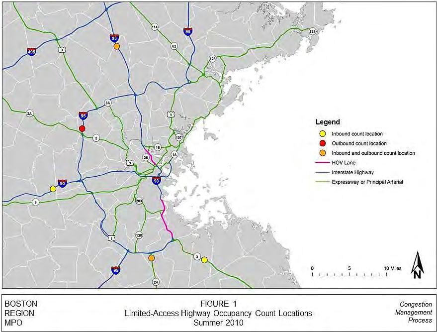
2 Boston Region MPO April 0, 0 7. I-9, southbound, between exits and in Wilmington Data collection took place in the morning (7:00 9:00 AM) for inbound traffic (in the direction of downtown Boston) and in the afternoons (:00 6:00 PM) for outbound traffic. Data were collected by MPO staff; each staff member monitored one lane and recorded the number of occupants in each vehicle that passed using a mechanical tally counting board. Data collection presented some challenges. In particular, a visual assessment of how many people are in a passing vehicle can be challenging depending on factors such as lighting conditions, vehicle speed, and vehicle window tinting. Also, given the limitedaccess design of freeways and the high speed of traffic, it was difficult to find a safe location, with clear lines of sight, from which to collect data. The safety of the data collectors was a significant factor in the choice of locations. To this end, rest stop locations were sought for observers to park their vehicles and also have a clear sight distance. For four of the seven locations at which data were collected, a MassDOT van was required in order to assure adequate safety. Assumptions Because of the difficulty, or in some cases impossibility, of counting the number of occupants inside certain types of vehicles, the following assumptions were made when calculating the average vehicle occupancy numbers: in the category were assumed to have an occupancy of 5.5. es were assumed to have an occupancy of 0. es were assumed to have an occupancy of 5. Police, fire, and vehicles were assumed to have an occupancy of. in the Known category were assumed to have an occupancy of. This includes limousines and other vehicles with blacked-out windows and vehicles for which visibility did not permit an accurate count. These assumptions were developed by staff. Although they are not necessarily specific to the locations, it was not possible to develop any more location-specific assumptions for these particular vehicle types. RESULTS BY LOCATION Figure shows the count locations, as well as the locations of the HOV lanes. Locations are in geographical order clockwise from southeast to north.
3 Boston Region MPO April 0, 0 Route Northbound Table shows summer 00 vehicle occupancy data for Route northbound, between exits 5 and 6 in Weymouth. Data were collected on June 5, between 7:00 AM and 9:00 AM. At this location, there are two general-purpose lanes and one breakdown lane, which is used for general-purpose traffic from 6:00 AM to 0:00 AM. The hourly volumes ranged between,706 and,59 vehicles, totaling 5,965 vehicles during the two-hour period. The occupancy rate for each lane was. persons per vehicle. Approximately 7,79 persons in 5,965 vehicles were counted. Route Northbound Table shows summer 00 vehicle occupancy data for Route, at the construction site near the I-9 ramps in Randolph, in the northbound direction. Data were collected on July 7, between 7:00 AM and 9:00 AM. There are three general-purpose lanes at this location. The hourly volumes ranged from,8 to,7 vehicles, totaling 9, vehicles during the two-hour period. The average vehicle occupancy across all three lanes was. persons per vehicle. Approximately,8 persons in 9, vehicles were counted. A MassDOT van was needed for safe data collection at this location. Route Southbound Table shows summer 00 vehicle occupancy data for Route, at the construction site near the I-9 ramps in Randolph, in the southbound direction. Data were collected on June 9, between :00 PM and 6:00 PM. There are three general-purpose lanes at this location. The hourly volumes ranged from 5,8 to 5,660 vehicles, totaling,078 vehicles during the two-hour period. The average vehicle occupancy across all three lanes was.0 persons per vehicle. Approximately,8 persons in,078 vehicles were counted. A MassDOT van was needed for safe data collection at this location.
4 Boston Region MPO April 0, 0 I-90/Mass Turnpike Eastbound Table shows summer 00 vehicle occupancy data for I-90/Mass Turnpike, eastbound, between exits and in Natick. Data were collected on June, between 7:00 AM and 9:00 AM. There are three general-purpose lanes at this location. The hourly volume ranged between,76 and 5,0 vehicles, totaling 9,08 vehicles during the two-hour period. The average vehicle occupancy across all three lanes was.9 persons per vehicle. Approximately 0,9 persons in 9,08 vehicles were counted. I-95 Northbound Table 5 shows summer 00 vehicle occupancy data for I-95 in Lexington, between exits 0A and 0B, in the northbound direction. Data were collected on June, between :00 PM and 6:00 PM. There are four general-purpose lanes at this location. The hourly volumes ranged from 5,089 to 5,87 vehicles, totaling 0,76 vehicles during the two-hour period. The average vehicle occupancy across all four lanes was. persons per vehicle. Approximately,79 persons in 0,76 vehicles were counted. I-9 Northbound Table 6 shows summer 00 vehicle occupancy data for I-9 in Wilmington, at the emergency pullout between exits and, in the northbound direction. Data were collected on July 7, between :00 PM and 6:00 PM. There are four general-purpose lanes at this location. The hourly volumes ranged from 6,98 to 6,65 vehicles, totaling,8 vehicles during the two-hour period. The average vehicle occupancy across all four lanes was. persons per vehicle. Approximately 5,96 persons in,8 vehicles were counted. A MassDOT van was needed for safe data collection at this location.
5 Boston Region MPO 5 April 0, 0 I-9 Southbound Table 7 shows summer 00 vehicle occupancy data for I-9 in Wilmington, at the emergency pullout between exits and, in the southbound direction. Data were collected on June 9, between 7:00 AM and 9:00 AM. There are four general-purpose lanes at this location. The hourly volumes ranged from 5,06 to 6,5 vehicles, totaling,60 vehicles during the two-hour period. The average vehicle occupancy across all four lanes was. persons per vehicle. Approximately,858 persons in,60 vehicles were counted. A MassDOT van was needed for safe data collection at this location. CONCLUSIONS Table 8 shows a summary of the results from summer 00 freeway vehicle-occupancy counts. Route southbound had the highest average weighted vehicle occupancy (.), while I-9 southbound had the lowest (.). The slightly higher occupancy counts on Route and Route may be partially explained by the proximity of the count locations to the southern end point of the Southeast Expressway HOV lane. At these locations, it may be assumed that a large proportion of northbound morning traffic was headed toward downtown Boston via the Southeast Expressway. The availability of an HOV lane along the Southeast Expressway may give drivers an incentive to seek higher-occupancy commuting options. The same is true for southbound afternoon traffic on Route ; a significant proportion of vehicles may have come from the HOV lane. The same effect was not observed at the I-9 location. Although traffic at this location was headed toward the I-9 North HOV lanes, occupancy here was the lowest (.). However, the count location is much farther from the I-9 North HOV lane, and would have captured traffic headed for I-95 as well. I-9 in the southbound direction also had the highest percentage of single-occupant vehicles (9%), while Route southbound had the lowest (80%). Percentages of twooccupant vehicles were highest at Route southbound (7%), Route northbound (%), and I-9 northbound (%), again suggesting HOV lanes have an impact on commuting decisions.
6 Boston Region MPO 6 April 0, 0 Results from the HOV monitoring performed by staff in the fall of 00 may reinforce this conclusion (see Appendices and ). The Southeast Expressway general-purpose lanes and HOV lanes were last monitored from 6:00 AM to 0:00 AM on Tuesday, November 6, 00. Between 7:00 AM and 9:00 AM, the average weighted vehicle occupancy (using the same weightings as were used for the general-purpose freeway occupancy counts described in this memo) was.60 for the northbound HOV lanes and.09 for the northbound general-purpose lanes. Assuming that both the summer 00 freeway occupancy counts and the fall 00 HOV lane occupancy counts represent typical morning traffic, it can be inferred that a substantial number of + person vehicles counted at the Route and Route locations were headed to or from the HOV lanes. For the counts done on June 9 and July 7, it is possible that holiday-related travel around the weekend of July th resulted in higher numbers of high-occupancy vehicles than normal, creating some bias in the data. However, efforts were made to avoid bias by scheduling counts during the middle of the week (Tuesdays and Wednesdays) and at least one day before or after the official holiday weekend. The two appended tables are from the memorandum, Observed Travel s, Occupancies, and Travel Savings: I-9 North and Southeast Expressway High-- Lanes, Fall 00 (Central Transportation Planning Staff, December 6, 00), pp. 6 and 8.
7
8 TABLE Route Northbound Counts June 5, 00 7:00 9:00 AM Start *** Average Weighted 7:00 8:00 AM 8:00 9:00 AM TOTAL 7:00 9:00 AM, ,59,96.0,5 09 0,706,6. 5, ,965 7,79. *Includes motorcycles, unmarked police vehicles, and taxis without passengers. **Includes limousines and other vehicles with blacked-out windows and vehicles for which visibility did not permit an accurate count. ***Assumes vehicle occupancies of 5.5 for vehicles, 0 for micro, 5 for, and for and Known.
9 TABLE Route Northbound Counts July 7, 00 7:00 9:00 AM Start *** Average Weighted 7:00-8:00 AM 8:00-9:00 AM TOTAL 7:00-9:00 AM, ,7 5,8., ,8 5,. 7,69, ,,8.
10 TABLE Route Southbound Counts June 9, 00 :00 6:00 PM Start *** Average Weighted :00 5:00 PM 5:00 6:00 PM TOTAL :00 6:00 PM, ,660 7,8.0, ,8 7,00.9 8,8, ,078,8.0
11 TABLE I-90/Mass. Turnpike Eastbound Counts June, 00 7:00 9:00 AM Start *** Average Weighted 7:00 8:00 AM 8:00 9:00 AM TOTAL 7:00 9:00 AM, ,0 5,99.8, ,76,98.9 8, ,08 0,9.9
12 TABLE 5 I-95 Northbound Counts June, 00 :00 6:00 PM Start *** Average Weighted :00 5:00 PM 5:00 6:00 PM TOTAL :00 6:00 PM, ,87 6,0.6, ,089 5,68. 9, ,76,79.
13 TABLE 6 I-9 Northbound Counts July 7, 00 :00 6:00 PM Start *** Average Weighted :00 5:00 PM 5:00 6:00 PM TOTAL :00 6:00 PM 5, ,98 8,08.5 5, ,5 7,98. 0,70, ,8 5,96.
14 TABLE 7 I-9 Southbound Counts June 9, 00 7:00 9:00 AM Start *** Average Weighted 7:00-8:00 AM 8:00-9:00 AM TOTAL 7:00-9:00 AM 6, ,5 7,0.0, ,06 5,65. 0, ,60,858.
15 TABLE 8 Summary of Results from Summer 00 Freeway Counts Location Direction of Traffic Date of Data Collection of Data Collection Number of Lanes Average Weighted Percent of with Person Percent of with Route Northbound Tuesday, June 5, 00 7:00 9:00 AM (including breakdown) 5,965 7,79. 88% 0% Route Northbound Wednesday, July 7, 00 7:00 9:00 AM 9,,8. 8% % Route Southbound Tuesday, June 9, 00 :00 6:00 PM,078,8.0 80% 7% I-90/Mass. Turnpike Eastbound Wednesday, June, 00 7:00 9:00 AM 9,08 0,9.9 88% % I-95 Northbound Tuesday, June, 00 :00 6:00 PM 0,76,79. 9% 8% I-9 Northbound Wednesday, July 7, 00 :00 6:00 PM,8 5,96. 8% % I-9 Southbound Tuesday, June 9, 00 7:00 9:00 AM,60,858. 9% 6%
16 Appendix I-9 Southeast Expressway Northbound General-Purpose and HOV Lane Counts November 6, 00 Lane Type *** 6:00 7:00 AM HOV, ,6,6.6 General 5, ,506 6,6. All 5,6,55 7 6,7 9,78.9 7:00 8:00 AM HOV 5, ,96, General, ,80,96. All,, ,676 8,00. 8:00 9:00 AM HOV ,00,65.6 General, ,6, All,87, ,56 7,58.7 9:00 0:00 AM HOV ,.66 General, , 6,06. All,970, ,78 8,59. 6:00 0:00 AM HOV, ,68,68.6 General 8,56, ,77,966. All 8,596, ,0,.8
17 Appendix I-9 Southbound General-Purpose and HOV Lane Counts November 7, 00 Lane Type *** 6:00 7:00 AM HOV ,7. General, ,957,80.8 All, ,70 5,. 7:00 8:00 AM HOV ,0.6 General, ,797,99.07 All, ,57 5,05. 8:00 9:00 AM HOV ,005.5 General, ,56,78.0 All, ,,789. 9:00 0:00 AM HOV ,6.00 General, ,87,.5 All, ,66 5, :00 0:00 AM HOV 58, ,06 8,.6 General 0, ,5,570. All,0, ,59 0,7.5
MEMORANDUM. for HOV Monitoring on I-93 North and the Southeast Expressway, Boston Region MPO, November, 2011.
 MEMORANDUM Date: January 12, 2012 To: Congestion Management Process Files From: Seth Asante, Ryan Hicks, and Efi Pagitsas MPO Staff Re: Historical Trends: Travel Times and Vehicle Occupancy Levels for
Appendix 4.1 J. May 17, 2010 Memorandum from CTPS to the Inter Agency Coordinating Group
 Appendix 4.1 J May 17, 2010 Memorandum from CTPS to the Inter Agency Coordinating Group CTPS CENTRAL TRANSPORTATION PLANNING STAFF Staff to the Boston Region Metropolitan Planning Organization MEMORANDUM
6 HIGH-OCCUPANCY-VEHICLE (HOV) LANES AND TRAVEL DEMAND MANAGEMENT (TDM) PROGRAMS
 LANES AND TRAVEL DEMAND MANAGEMENT (TDM) PROGRAMS") 6 HIGH-OCCUPANCY-VEHICLE (HOV) LANES AND TRAVEL DEMAND MANAGEMENT (TDM) PROGRAMS Travel demand management (TDM) programs enable roadways, which have a fixed capacity, to accommodate more travelers without
6 HIGH-OCCUPANCY-VEHICLE (HOV) LANES AND TRAVEL DEMAND MANAGEMENT (TDM) PROGRAMS Travel demand management (TDM) programs enable roadways, which have a fixed capacity, to accommodate more travelers without
HOV LANE PERFORMANCE MONITORING: 2000 REPORT EXECUTIVE SUMMARY
 Final Report Research Project Agreement No. T1803, Task 4 HOV Monitoring V HOV LANE PERFORMANCE MONITORING: 2000 REPORT EXECUTIVE SUMMARY by Jennifer Nee TRAC Research Engineer John Ishimaru TRAC Senior
DISTRICT EXPRESS LANES ANNUAL REPORT FISCAL YEAR 2017 JULY 1, 2016 JUNE 30, FloridaExpressLanes.com
 DISTRICT EXPRESS LANES ANNUAL REPORT FISCAL YEAR 2017 JULY 1, 2016 JUNE 30, 2017 FloridaExpressLanes.com This page intentionally left blank. TABLE OF CONTENTS List of Figures... ii List of Tables.... ii
Central Coast Origin-Destination Survey
 Central Coast Origin-Destination Survey July 2016 Central Coast Origin-Destination Survey Prepared for: Santa Barbara County Association of Governments San Luis Obispo Council of Governments Ventura County
Toronto 2015 Pan Am/Parapan Am Games Temporary Traffic By-law Amendments for High Occupancy Vehicle Lanes (Supplementary Report)
") STAFF REPORT ACTION REQUIRED Toronto 2015 Pan Am/Parapan Am Games Temporary Traffic By-law Amendments for High Occupancy Vehicle Lanes (Supplementary Report) Date: March 25, 2015 To: From: Wards: Reference
STAFF REPORT ACTION REQUIRED Toronto 2015 Pan Am/Parapan Am Games Temporary Traffic By-law Amendments for High Occupancy Vehicle Lanes (Supplementary Report) Date: March 25, 2015 To: From: Wards: Reference
Interstate 90 and Mercer Island Mobility Study APRIL Commissioned by. Prepared by
 Interstate 90 and Mercer Island Mobility Study APRIL 2017 Commissioned by Prepared by Interstate 90 and Mercer Island Mobility Study Commissioned by: Sound Transit Prepared by: April 2017 Contents Section
MEMORANDUM. Open Section Background. I-66 Open Section Study Area. VDOT Northern Virginia District. I-66 Project Team. Date: November 5, 2015
 MEMORANDUM To: VDOT Northern Virginia District From: I-66 Project Team Date: November 5, 2015 Subject: Open Section Background The purpose of this technical memorandum is to provide narrative and technical
rtc transit Before and After Studies for RTC Transit Boulder highway UPWP TASK Before Conditions
 rtc transit Before and After Studies for RTC Transit UPWP TASK 3403-11-14 Before Conditions Report Boulder highway June 2011 Before and After Studies for RTC Transit BOULDER HIGHWAY BEFORE STUDY UPWP Task
Research Report Agreement T4118, Task 24 HOV Action Plan HOV ACTION PLAN
 Research Report Agreement T4118, Task 24 HOV Action Plan HOV ACTION PLAN by John M. Ishimaru Senior Research Engineer Duane Wright Systems Analyst Programmer Mark E. Hallenbeck Director Jaime Kang Research
5.1 Traffic and Transportation
 5.1 When it opens in 2009, the Bellevue Nickel Improvement Project will increase the number of vehicles able to travel through the study area, improve travel speeds, and improve safety by reducing the
TABLE OF CONTENTS. Coral Springs Charter High School and Middle School Job No Page 2
 Job No. 15-019 Page 2 TABLE OF CONTENTS 1.0 INTRODUCTION... 4 2.0 EXISTING CONDITIONS... 5 3.0 TRAFFIC GENERATION... 7 4.0 TRIP DISTRIBUTION... 8 5.0 FUTURE CONDITIONS... 8 6.0 SITE ACCESS...13 7.0 CONCLUSION...13
B. Congestion Trends. Congestion Trends
 B. Congestion Trends Congestion Trends There are two types of congestion that impact mobility: recurring and non-recurring congestion. Recurring congestion is related to segments of roadway that are over
Washington State Transportation Commission
 Washington State Transportation Commission I-405 express toll lanes Patty Rubstello, Assistant Secretary of Tolling May 17, 2016 Agenda I-405 Six Month Update Key Takeaways Performance update Impact to
CONGESTION MONITORING THE NEW ZEALAND EXPERIENCE. By Mike Curran, Manager Strategic Policy, Transit New Zealand
 CONGESTION MONITORING THE NEW ZEALAND EXPERIENCE 26 th Australasian Transport Research Forum Wellington New Zealand 1-3 October 2003 By, Manager Strategic Policy, Transit New Zealand Abstract New Zealand
Evaluation of High-Occupancy-Vehicle
 TRANSPORTATION RESEARCH RECORD 1446 Evaluation of High-Occupancy-Vehicle Lanes in Phoenix, Arizona MARK J. POPPE, DAVID J.P. HOOK, AND KEN M. HOWELL High-occupancy-vehicle (HOV) lanes were first introduced
APPENDIX J MODIFICATIONS PERFORMED TO THE TOR
 APPENDIX J MODIFICATIONS PERFORMED TO THE TOR This appendix summarizes the modifications that were performed in years 2012 and 2017 to rectify calculation errors that were observed in the data presented
Kingston Transportation Master Plan Draft Report Transit Forecasting 1
 TRANSIT FORECASTING Transit Forecasting 1 INTRODUCTION A spreadsheet model was developed to identify existing transit deficiencies and additional transit service requirements. The model comprised transit
CITY MANAGER S OFFICE CITY OF MERCER ISLAND, WASHINGTON 9611 SE 36 th Street Mercer Island, WA (206)
") CITY MANAGER S OFFICE CITY OF MERCER ISLAND, WASHINGTON 9611 SE 36 th Street Mercer Island, WA 98040-3732 (206) 275-7600 www.mercergov.org August 18, 2016 Mr. Daniel M. Mathis Division Administrator Federal
CITY MANAGER S OFFICE CITY OF MERCER ISLAND, WASHINGTON 9611 SE 36 th Street Mercer Island, WA 98040-3732 (206) 275-7600 www.mercergov.org August 18, 2016 Mr. Daniel M. Mathis Division Administrator Federal
BOSTON REGION METROPOLITAN PLANNING ORGANIZATION
 PLANNING ORGANIZATIO BOSTON REGION MPO NMETROPOLITAN BOSTON REGION METROPOLITAN PLANNING ORGANIZATION Stephanie Pollack, MassDOT Secretary and CEO and MPO Chair Karl H. Quackenbush, Executive Director,
 Appendix H1 Traffic Study Hill St Obispo Ave Obispo Ave Student Drop-off & Pick-up Area Parking Lot Plaza Level Hill St Fire Lane Access Service Lane Access Redondo Ave Redondo Ave Parking Lot N No
Inauguration 2017 Dulles Tower
 Inauguration 2017 Dulles Tower Presented to: IAD Users By: IAD Staff, Management and NATCA Date:1/3/2017 General Information Inauguration takes place Friday, January 20, 2017 at 1200 (noon) local. The
Memorandum. Roger Millar, Secretary of Transportation. Date: April 5, Interstate 90 Operations and Mercer Island Mobility
 Memorandum To: From: The Honorable Dow Constantine, King County Executive; The Honorable Ed Murray, City of Seattle Mayor; The Honorable Bruce Bassett, City of Mercer Island Mayor; The Honorable John Stokes,
MEMORANDUM. Lynn Hayes LSA Associates, Inc.
 MEMORANDUM To: Lynn Hayes LSA Associates, Inc. Date: May 5, 217 From: Zawwar Saiyed, P.E., Senior Transportation Engineer Justin Tucker, Transportation Engineer I Linscott, Law & Greenspan, Engineers LLG
BICYCLE AND PEDESTRIAN COUNT PROGRAM 2016 Annual Report
 BICYCLE AND PEDESTRIAN COUNT PROGRAM 2016 Annual Report TABLE OF CONTENTS A Message from the Mayor... 4 Data Count Reports... 5 Count Locations... 6 Count Locations Map... 7 Trail Data... 8 International
SANTA CLARA COUNTY I-280 CORRIDOR STUDY
 SANTA CLARA COUNTY I-280 CORRIDOR STUDY Appendix B 2 Technical Memorandum Existing Transportation Condition Memo SANTA CLARA VALLEY TRANSPORTATION AUTHORITY (VTA) 1-1 Introduction The I-280 Corridor Study
EXISTING CONDITIONS A. INTRODUCTION. Route 107 Corridor Study Report
 II. EXISTING CONDITIONS A. INTRODUCTION The Route 107 study area extends from the south at Chestnut Street in Lynn approximately 3.7 miles to the north to Boston Street in Salem. The study area has three
Analysis of Transit Fare Evasion in the Rose Quarter
 Analysis of Transit Fare Evasion in the Rose Quarter Shimon A. Israel James G. Strathman February 2002 Center for Urban Studies College of Urban and Public Affairs Portland State University Portland, OR
ETS Park & Ride Report Summer 2017
 Urban Form And Corporate Strategic Development City Planning 8th Floor, Edmonton Tower 10111-104 Avenue NW Edmonton, AB T5J 0J4 Tel.: 780.496.6086 Email: varjinder.chane@edmonton,ca ETS Park & Ride Report
I-93/Southeast Expressway/Route 3 (Braintree Split)
") I-/Southeast Expressway/Route 3 (Braintree Split) Operational Assessment and Potential Improvements A report produced by the Central Transportation Planning Staff for the Boston Region Metropolitan Planning
I-/Southeast Expressway/Route 3 (Braintree Split) Operational Assessment and Potential Improvements A report produced by the Central Transportation Planning Staff for the Boston Region Metropolitan Planning
Northern Ontario Passenger Vehicle Travel Profile
 TRANSPORTATION Final Report The Preparation of a Northern Ontario Passenger and Commercial Vehicle Origin-Destination Survey Northern Ontario Passenger Vehicle Travel Profile Submitted to Ministry of Transportation,
TRAFFIC IMPACT STUDY REPORT FOR PROPOSED OFFICE PROJECT AT 959 SEWARD STREET IN HOLLYWOOD SNYDER PARTNERS
 DRAFT TRAFFIC IMPACT STUDY REPORT FOR PROPOSED OFFICE PROJECT AT 959 SEWARD STREET IN HOLLYWOOD Prepared for: SNYDER PARTNERS Prepared by: Crain & Associates 2007 Sawtelle Boulevard, Suite 4 Los Angeles,
Public Information Meetings. October 5, 6, 7, and 15, 2015
 Public Information Meetings October 5, 6, 7, and 15, 2015 Project Map 2 Project Context Only Interstate in the Country limited to HOV only traffic during rush hours Stoplight at the end of I-66 eastbound
Watts St westbound thru
 Executive Summary At the request of the Hudson Square Business Improvement District, Sam Schwartz Engineering, DPC (Sam Schwartz) has completed a technical analysis of various congestion pricing and/or
Word Count: 3,565 Number of Tables: 4 Number of Figures: 6 Number of Photographs: 0. Word Limit: 7,500 Tables/Figures Word Count = 2,250
 Katherine F. Turnbull, Ken Buckeye, Nick Thompson 1 Corresponding Author Katherine F. Turnbull Executive Associate Director Texas Transportation Institute Texas A&M University System 3135 TAMU College
FIRST WEEK UPDATE: 66 EXPRESS LANES INSIDE THE BELTWAY Data from first four days shows faster, more reliable trips on I-66
 FOR IMMEDIATE RELEASE Tuesday, December 12, 2017 CONTACT: Michelle T. Holland 703-586-0487 (C) Michelle.Holland@vdot.virginia.gov Jennifer McCord 571-230-2926 Jennifer.McCord@vdot.virginia.gov FIRST WEEK
Mainline Description
 Mainline Description The Mainline component of Florida s Turnpike extends for 320 miles and consists of five distinct sections as shown in the figure above. These sections are the SR 821 (HEFT), Southern
2006 WEEKDAY TRAFFIC PROFILE. June 15, 2007
 June 15, 2007 Mr. Gary Stobb, P.E. Director of Planning/Operations Harris County Toll Road Authority 330 Meadowfern, Suite 200 Houston, TX 77067 Re: Westpark Tollway Value Pricing Analysis Dear Mr. Stobb:
FIRST WEEK UPDATE: 66 EXPRESS LANES INSIDE THE BELTWAY Data from first four days shows faster, more reliable trips on I-66
 Subject: FIRST WEEK UPDATE: 66 EXPRESS LANES INSIDE THE BELTWAY From: VDOT-News To: Time: Tuesday, December 12, 2017 9:05:36 AM -08:00 RELEASE: IMMEDIATE Michelle Holland,
According to FAA Advisory Circular 150/5060-5, Airport Capacity and Delay, the elements that affect airfield capacity include:
 4.1 INTRODUCTION The previous chapters have described the existing facilities and provided planning guidelines as well as a forecast of demand for aviation activity at North Perry Airport. The demand/capacity
Traffic Analysis Final Report
 SR-71 Widening Project Project Approval/Environmental Documentation Traffic Analysis Final Report Prepared for Caltrans District 7 August 2012 6 Hutton Centre Drive, Suite 700 Santa Ana, California 92707
2010 El Paso Work Place Travel Survey Technical Summary
 2010 El Paso Work Place Travel Survey Technical Summary Prepared by the Texas A&M Transportation Institute June 2013 2010 El Paso Work Place Travel Survey TECHNICAL SUMMARY Texas Department of Transportation
I-10 West and Sunland Park Drive southbound will close July 13 at night. Detour onto North Mesa will be required.
 NEWS RELEASE a TxDOT Project For immediate release EL PASO DISTRICT Jennifer Wright (915) 790-4340 Jennifer.Wright3@txdot.gov I-10 West and Sunland Park Drive southbound will close July 13 at night. Detour
2009 Muskoka Airport Economic Impact Study
 2009 Muskoka Airport Economic Impact Study November 4, 2009 Prepared by The District of Muskoka Planning and Economic Development Department BACKGROUND The Muskoka Airport is situated at the north end
Public Meeting: Metropolitan Washington Airports Authority (MWAA) Transportation Network Company (TNC) Lot on S. Eads Street
 Transportation Network Company (TNC) Lot on S. Eads Street") Public Meeting: Metropolitan Washington Airports Authority (MWAA) Transportation Network Company (TNC) Lot on S. Eads Street Arlington County Department of Environmental Services Transportation Division
Public Meeting: Metropolitan Washington Airports Authority (MWAA) Transportation Network Company (TNC) Lot on S. Eads Street Arlington County Department of Environmental Services Transportation Division
2014 PERFORMANCE OF HIGH-OCCUPANCY VEHICLE FACILITIES ON FREEWAYS IN THE WASHINGTON REGION
 2014 PERFORMANCE OF HIGH-OCCUPANCY VEHICLE FACILITIES ON FREEWAYS IN THE WASHINGTON REGION Travel Forecasting Subcommittee Friday, May 22, 2015 C. Patrick Zilliacus Figure 1 HOV System Overview Montgomery
Evaluation of the Effectiveness of High Occupancy Vehicle Lanes
 Evaluation of the Effectiveness of High Occupancy Vehicle Lanes Peter T. Martin, Associate Professor Joseph Perrin, Research Assistant Professor Pen Wu and Rob Lambert, Research Assistants University of
Washington Dulles International Airport (IAD) Aircraft Noise Contour Map Update
 Aircraft Noise Contour Map Update") Washington Dulles International Airport (IAD) Aircraft Noise Contour Map Update Ultimate ASV, Runway Use and Flight Tracks 4th Working Group Briefing 8/13/18 Meeting Purpose Discuss Public Workshop input
Washington Dulles International Airport (IAD) Aircraft Noise Contour Map Update Ultimate ASV, Runway Use and Flight Tracks 4th Working Group Briefing 8/13/18 Meeting Purpose Discuss Public Workshop input
PLEASE SHARE THIS INFORMATION WITH YOUR STAFF AS APPROPRIATE
 Human Resources Memorandum Date: March 23, 2012 To: Copy To: From: RE: All School Principals Superintendent s Senior Staff Michael Shanahan, Ed.D. Chief Human Resources Officer School Summer Work Hours/Schedule
PORTS TORONTO Billy Bishop Toronto City Airport Summary of 2015 Traffic and Passenger Surveys
 PORTS TORONTO Billy Bishop Toronto City Airport Summary of 2015 Traffic and Passenger Surveys 1 Summary of 2015 BBTCA Traffic and Passenger Surveys Surveys of traffic volumes and pedestrian activity were
ETS Park & Ride Report Spring 2017
 Sustainable Development City Planning 8th Floor, Edmonton Tower 10111-104 Avenue NW Edmonton, AB T5J 0J4 Tel.: 780.496.6086 Email: varjinder.chane@edmonton,ca by Monitoring & Geospatial Services May, 2017
Finchley and Golders Green Area Committee 27 April 2017
 Finchley and Golders Green Area Committee 27 April 2017 Title Report of Wards Status Urgent Key Enclosures Officer Contact Details Junction of Regents Park Road / Tillingbourne Gardens, N3 Commissioning
Treasure Island Supplemental Information Report Addendum
 1 1 1 1 0 1 0 1 0 1 Treasure Island Supplemental Information Report Addendum Introduction Purpose The purpose of this Supplemental Information Report (SIR) Addendum is to determine if the current land
Pedestrian Safety Review Spadina Avenue
 STAFF REPORT ACTION REQUIRED Pedestrian Safety Review Spadina Avenue Date: October 13, 2015 To: Toronto and East York Community Council From: Director, Transportation Services, Toronto and East York District
McLean Citizens Association Transportation Committee Project Briefing
 McLean Citizens Association Transportation Committee Project Briefing November 10, 2015 Project Map 2 Project Context Only Interstate in the Country limited to HOV only traffic during rush hours Stoplight
7272 WISCONSIN AVENUE LOCAL AREA TRANSPORTATION REVIEW
 7272 LOCAL AREA TRANSPORTATION REVIEW AND TRANSPORTATION POLICY AREA REVIEW MONTGOMERY COUNTY, MARYLAND Submitted on behalf of Carr Properties Prepared by: Wells + Associates, Inc. Submission: July 1,
Minneapolis-St. Paul International Airport Monthly Runway Use System Report. June 2015
 Minneapolis-St. Paul International Airport Monthly Runway Use System Report June 2015 Environment Department, Noise Program Office Metropolitan Airports Commission 6040 28th Avenue South, Minneapolis,
Minneapolis-St. Paul International Airport Monthly Runway Use System Report. June 2016
 Minneapolis-St. Paul International Airport Monthly Runway Use System Report June 2016 Environment Department, Noise Program Office Metropolitan Airports Commission 6040 28th Avenue South, Minneapolis,
Site Location and Setting
 Memorandum Date: To: From: Subject: Kristy Le, Gary Black Steve Orem Santa Teresa County Park Historic Area Traffic and Parking Study Hexagon Transportation Consultants, Inc. has completed a traffic and
YARTS ON-BOARD SURVEY MEMORANDUM
 YARTS ON-BOARD SURVEY MEMORANDUM Prepared for the Yosemite Area Regional Transportation System Prepared by LSC Transportation Consultants, Inc. This page left intentionally blank. YARTS On-Board Survey
AVSP 7 Summer Section 20: Methodology
 AVSP 7 Summer 2016 Section 20: Methodology Visitor Volume Total Traffic The process of counting visitors to Alaska starts with traffic data for people exiting the state. The following table shows each
95 Express Managed Lanes Consolidated Analysis Technical Report
 95 Express Managed Lanes Consolidated Analysis Technical Report November 2011 FDOT District 4 Prepared by Cambridge Systematics, Inc Acronyms AVO Average Vehicle Occupancy CCTV Closed Circuit Television
KING STREET TRANSIT PILOT
 KING STREET TRANSIT PILOT Update toronto.ca/kingstreetpilot #kingstreetpilot HIGHLIGHTS TRANSIT RIDERSHIP TRANSIT CAPACITY To respond to this growth in ridership, the TTC has increased the capacity of
Lake Erie Commerce Center Traffic Analysis
 LOCATION: East of NYS Route 5 at Bayview Road Town of Hamburg Erie County, New York PREPARED BY: Wendel Companies 140 John James Audubon Parkway Suite 200 Amherst, New York 14228 January 2012 i ii Table
Improving Houston METRO HOV/HOT Lane Safety Fall TexITE: Fort Worth August 31 st, 2012 Dustin Qualls, PE, PTOE Nader Mirjamali, PE
 Improving Houston METRO HOV/HOT Lane Safety 2012 Fall TexITE: Fort Worth August 31 st, 2012 Dustin Qualls, PE, PTOE Nader Mirjamali, PE Agenda for Today s Presentation I. II. III. IV. V. Introduction to
I-66 Inside the Beltway Feasibility Study
 I-66 Inside the Beltway Feasibility Study Feasibility Study Study Process Context Sensitive Dialogues Corridor Assessments / Data Collection Problem Statement Refinement Concept Development Concept Evaluation
Estimating Tourism Expenditures for the Burlington Waterfront Path and the Island Line Trail
 A report by the University of Vermont Transportation Research Center Estimating Tourism Expenditures for the Burlington Waterfront Path and the Island Line Trail Report # 10-003 February 2010 Estimating
395 Express Lanes Major Closure Advisory
 395 Express Lanes Major Closure Advisory 3-Week Schedule Lane Closure And Construction Activities Week of February 26 th 1) Highway/Name & Route #: Braddock Road Bridge Lane/Shoulder Closure: Single Lane
I-75 in Hamilton County Project Termini
 I-75 in Hamilton County Project Termini Introduction As part of the North South Transportation Initiative (NSTI), capacity improvements were recommended for the I-75 corridor through Hamilton County from
Subject: B579 Luton Road, Chalton
 Meeting: Traffic Management Meeting Date: 7 th June 2018 Subject: B579 Luton Road, Chalton Report of: Summary: Paul Mason, Assistant Director Highways To report to the Executive Member for Community Services
CDOT North I-25 Express Lanes Update April 28, 2016
 CDOT North I-25 Express Lanes Update April 28, 2016 Why Express Lanes? CDOT/HPTE new focus on: Increased choice in travel Increased mobility through operational improvements Reduce delay on most seriously
USERS of EXISTING TOLL FACILITIES in HAMPTON ROADS
 USERS of EXISTING TOLL FACILITIES in HAMPTON ROADS PREPARED BY: SEPTEMBER 2012 T12-10 ii REPORT DOCUMENTATION TITLE Users of Existing Toll Facilities in Hampton Roads AUTHOR Robert B. Case, PE, PTOE ABSTRACT
December 1, Tim Martin Executive Director Stephens County Development Authority 31 W. Doyle Street Toccoa, GA
 December 1, 2017 Tim Martin Executive Director Stephens County Development Authority 31 W. Doyle Street Toccoa, GA 30577 tim@scda.biz Dear Mr. Martin, We are pleased to present this summary letter report
HOW TO IMPROVE HIGH-FREQUENCY BUS SERVICE RELIABILITY THROUGH SCHEDULING
 HOW TO IMPROVE HIGH-FREQUENCY BUS SERVICE RELIABILITY THROUGH SCHEDULING Ms. Grace Fattouche Abstract This paper outlines a scheduling process for improving high-frequency bus service reliability based
1.2 Corridor History and Current Characteristics
 SECTION 1 Description and Background of Study Area 1.1 Introduction This preliminary engineering report was prepared for the Alaska Department of Transportation and Public Facilities (ADOT&PF). It is part
V. DATA COLLECTION PROGRAM
 V. DATA COLLECTION PROGRAM As discussed in Section IV, an extensive data assembly and data collection program was undertaken to develop the data necessary to calibrate the existing Portway Extensions model
Crash and Behavioral Characteristics, and Health Outcomes, Associated with Vehicular Crashes by Tourists in Wisconsin,
 Crash and Behavioral Characteristics, and Health Outcomes, Associated with Vehicular Crashes by Tourists in Wisconsin, 1992-1996 Wayne Bigelow, M.S. Center for Health Systems Research & Analysis University
Freymond Aggregates Quarry Bay Lake Rd., Twp. of Faraday
 Freymond Aggregates Quarry Bay Lake Rd., Twp. of Faraday Traffic Brief South Site Entrance Prepared by: Tranplan Associates PO Box 455 Lakefield, ON K0L 2H0 www.tranplan.com Prepared for: EcoVue Consulting
ROUTE 103. Morrisville Shopping Shuttle ROUTE OVERVIEW
 ROUTE 103 Morrisville Shopping Shuttle ROUTE OVERVIEW Route 103 is a Shuttle route that operates between Stowe and Morrisville. The route travels primarily along VT Route 100 and provides service to Stowe
MORE TIME PLACEMENT HIGH TRAFFIC LOCATIONS 10-SECOND AD SPOTS
 STATE OF THE ART BETTER TECHNOLOGY MORE TIME PLACEMENT HIGH TRAFFIC LOCATIONS 10-SECOND AD SPOTS REACH & FREQUENCY Las Vegas Billboards is dedicated to giving the reach and frequency needed for a successful
Nashua Regional Planning Commission
 Nashua Regional Planning Commission Congestion Management Program Corridor Overview NH 111 is a major east-west arterial roadway that passes through 3 municipalities in the Nashua region. It enters the
TABLE OF CONTENTS Executive Summary. Convention Industry Overview and Trends. Convention Market Competitive and Comparable Analysis
 TABLE OF CONTENTS ----------- Executive Summary Chapter 1 Appendix A Appendix B Appendix C Appendix D Appendix E Appendix F Demand and Impact Convention Industry Overview and Trends Convention Market Competitive
95 Express Monthly Operations Report May 2017
 95 Express Operations Report May 17 95 Express currently has three dynamically-priced tolling segments in each direction. Segment 1 is in Miami-Dade County from just north of SR 836 to the Golden Glades
Assessment of Travel Trends
 I - 2 0 E A S T T R A N S I T I N I T I A T I V E Assessment of Travel Trends Prepared for: Metropolitan Atlanta Rapid Transit Authority Prepared by: AECOM/JJG Joint Venture Atlanta, GA October 2011 General
I-405 Express Toll Lanes Coming in 2015
 I-405 Express Toll Lanes Coming in 2015 Jennifer Charlebois Roadway Toll Systems PE, Toll Division Anne Broache Public Information, I-405/SR 167 Lynn Peterson Secretary of Transportation Market Neighborhood
Organization Date. Sound Regional Council Regional Project Evaluation Committee. Brian Nielsen, Program Administrator
 Organization Puget Date Sound Regional Council Regional Project Evaluation Committee Brian Nielsen, Program Administrator October 26, 2018 TODAY S FOCUS The big picture #Realign99 closure/opening the tunnel
95 Express Monthly Operations Report July 2017
 95 Express Operations Report July 17 95 Express currently has three dynamically-priced tolling segments in each direction. Segment 1 is in Miami-Dade County from just north of SR 836 to the Golden Glades
Arlington County Board Meeting Project Briefing. October 20, 2015
 Arlington County Board Meeting Project Briefing October 20, 2015 Project Map 2 Project Context Only Interstate in the Country limited to HOV only traffic during rush hours Stoplight at the end of I-66
The purpose of this Demand/Capacity. The airfield configuration for SPG. Methods for determining airport AIRPORT DEMAND CAPACITY. Runway Configuration
 Chapter 4 Page 65 AIRPORT DEMAND CAPACITY The purpose of this Demand/Capacity Analysis is to examine the capability of the Albert Whitted Airport (SPG) to meet the needs of its users. In doing so, this
Capital Beltway HOT Lanes Project
 New Travel Choices Ahead Some things can t wait for traffic Capital Beltway HOT Lanes Project Project Update August 16, 2011 Major Milestones Reached Some things can t wait for traffic Project over 75%
INTERSTATE 395 EXPRESS LANES NORTHERN EXTENSION TRAFFIC & TRANSPORTATION TECHNICAL REPORT SEPTEMBER 2016
 INTERSTATE 395 EXPRESS LANES NORTHERN EXTENSION TRAFFIC & TRANSPORTATION TECHNICAL REPORT SEPTEMBER 2016 INTERSTATE 395 EXPRESS LANES NORTHERN EXTENSION Traffic and Transportation Technical Report City
CHAPTER 4 DEMAND/CAPACITY ANALYSIS
 CHAPTER DEMAND/CAPACITY ANALYSIS INTRODUCTION The demand/capacity analysis examines the capability of the airfield system at Blue Grass Airport (LEX) to address existing levels of activity as well as determine
CALIFORNIA HIGH-OCCUPANCY VEHICLE LANE DEGRADATION ACTION PLAN
 CALIFORNIA DEPARTMENT OF TRANSPORTATION CALIFORNIA HIGH-OCCUPANCY VEHICLE LANE DEGRADATION ACTION PLAN Prepared by Division of Traffic Operations Office of Traffic Management Submitted to Federal Highway
2017 Work and Launch of the Next Phase. Information meeting, Montréal-Ouest September 14, 2017
 2017 Work and Launch of the Next Phase Information meeting, Montréal-Ouest September 14, 2017 2 Presentation Outline Work progress Launch of the next phase Mitigation measures Dismantling Communications
AGENDA ITEM I-6 Public Works
 AGENDA ITEM I-6 Public Works STAFF REPORT City Council Meeting Date: 8/6/2018 Staff Report Number: 18-150-CC Informational Item: Update on the Willow Road and highway 101 interchange construction, upcoming
77 McDonnell-Lindbergh - Monday thru Friday NORTHBOUND Effective: March 18, Shopping Center North County. Shopping Center Washington &
 77 McDonnell- - Monday thru Friday NORTHBOUND Effective: March 18, 2019 & Valley Industries 4:53A 4:59A 5:10A 5:18A 5:27A 5:39A 5:33A 5:39A 5:50A 5:58A 6:07A 6:19A 6:13A 6:19A 6:31A 6:39A 6:49A 7:02A 6:53A
Parking Amendments - Bay Street, between Harbour Street and Queens Quay West (York Street, Bay Street, and Yonge Street Ramp Removal)
") REPORT FOR ACTION between Harbour Street and Queens Quay West (York Street, Bay Street, and Yonge Street Ramp Removal) Date: October 26, 2017 To: Toronto and East York Community Council From: Acting Director,
REPORT FOR ACTION between Harbour Street and Queens Quay West (York Street, Bay Street, and Yonge Street Ramp Removal) Date: October 26, 2017 To: Toronto and East York Community Council From: Acting Director,
A. CONCLUSIONS OF THE FGEIS
 Chapter 11: Traffic and Parking A. CONCLUSIONS OF THE FGEIS The FGEIS found that the Approved Plan will generate a substantial volume of vehicular and pedestrian activity, including an estimated 1,300
RACINE COUNTY PUBLIC TRANSIT PLAN:
 RACINE COUNTY PUBLIC TRANSIT PLAN: 2013-2017 Recommended Transit Service Improvement Plan NEWSLETTER 3 SEPTEMBER 2013 This newsletter describes the final recommended public transit plan for the City of