Las Conchas Wildfire (NM):
|
|
|
- Laurence Stokes
- 5 years ago
- Views:
Transcription
:")


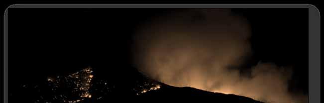
1 Las Conchas Wildfire (NM): Progression, Management, and Context Kristen Honig Los Alamos National Laboratory July 24, 2012 LA UR Photo Credit: Kristen Honig

2 Las Conchas Fire Background Fire Timeline/Summary Daily Growth Acres by Agency Burn Severity Historical Fires Observations Photo Credit: Kristen Honig / USFS
 Temperature (Mean Daily Max): 90.")
3 Incident Background Information Location: Jemez Mountains, north central NM Land ownership: Federal Property (USFS, DOI, DOE) Native American Tribal Lands Urban Areas (Los Alamos & White Rock) Private property scattered throughout Topography: steep canyons & mesa tops Elevation: 10,720 5,980 feet Point of Origin Tower RAWS Station (July 2011) Temperature (Mean Daily Max): 90.8 F Relative Humidity (Mean Daily Min): 15% Wind gusts of 41 mph first day of fire RAWS 6,500 ft
 Vegetation: FM8 and FM10 (Timber) Ponderosa Pine & Mixed Conifer")

 Current Forest Conditions: Increased forest densities since")

4 Incident Background Information (cont.) Vegetation: FM8 and FM10 (Timber) Ponderosa Pine & Mixed Conifer Piñon Juniper woodlands Historic Forest Conditions: pre 1900 Open canopy, large diameter trees Frequent, low intensity surface fire Fire return interval 5 to 25 years (Allen et al. 1998) Current Forest Conditions: Increased forest densities since early 1900 s Persistent drought across Southwest since 1996 High intensity, stand replacing crown fires Photo Credit: USFS Photo Credit: USFS Photo Credit: Kristen Honig / NPS Photo Credit: Kristen Honig

 4:30 pm Type 1 Incident Mgmt Team (IMT) ordered (Reinarz IC)")
 Photo Credit: Kristen Honig Photo Credit: Kristen Honig Photo")
5 Las Conchas Fire Timeline: DAY 1 Sunday, June 26 1:00 pm aspen tree falls into powerline and starts fire 13 miles SW of Los Alamos Local resources respond Incident Commander (Morales, Santa Fe NF) 3:30 pm air tankers ordered (400 acres) 4:30 pm Type 1 Incident Mgmt Team (IMT) ordered (Reinarz IC) Evacuations: rural private property, federal lands (Bandelier and Valles Caldera NP) Photo Credit: Kristen Honig Photo Credit: Kristen Honig Photo Credit: Kristen Honig
 5:00 pm 1 acre spotfire contained at Los Alamos National Laboratory (LANL) (~50,000 acres total) 6:00 pm Reinarz IMT takes over management of")
6 Las Conchas Fire Timeline DAY 2 Monday, June 27 3:00 am fire mapped at 43,597 acres (IR imagery) MaxROS ~acre/second 1:30 pm mandatory evacuation of Los Alamos; voluntary evacuation of White Rock & Cochiti Pueblo (~20,000 people) 5:00 pm 1 acre spotfire contained at Los Alamos National Laboratory (LANL) (~50,000 acres total) 6:00 pm Reinarz IMT takes over management of fire
7 DAY 3 Tuesday, June 28 60,741 acres Las Conchas Fire Timeline Short range spotting and crown runs; growth in all directions DAY 4 Wednesday, June 29 69,555 acres Long range spotting on NE edge of fire; advanced into Santa Clara Canyon (exceeded Temp Flight Restriction) Area Command (Oltrogge AC) and a second Type 1 IMT (Hughes IC) assigned to fire Split into zones: North Zone: Reinarz IMT South Zone: Hughes IMT

8 Las Conchas Fire Timeline DAY 5 Thursday, June 30 92,735 acres Advanced NE past NM 144 into Cerro Grande Fire scar DAY 6 Friday, July 1 103,993 acres Largest fire in NM history* DAY 7 Saturday, July 2 113,734 acres Advanced SW into Bland, Cochiti, and Peralta Canyon DAY 8 Sunday, July 3 121,248 acres Evacuation lifted Los Alamos *Surpassed by the 2012 Whitewater-Baldy Complex, Gila NF
 assigned to NW Zone Extreme fire behavior w/in perimeter Reached South Fork fire scar to north DAY 11 Wednesday, July 6 130,691 acres Terrain driven fire runs in drainages including")
9 DAY 9 Monday, July 4 123,563 acres Las Conchas Fire Timeline E/NE winds pushed fire toward north slope of Chicoma Peak (sacred mountain) DAY 10 Tuesday, July 5 127,821 acres Third Type 1 IMT (Morcom IC) assigned to NW Zone Extreme fire behavior w/in perimeter Reached South Fork fire scar to north DAY 11 Wednesday, July 6 130,691 acres Terrain driven fire runs in drainages including GuajeCanyon

10 Las Conchas Fire Timeline DAY 12 Thursday, July 7 136,955 acres Flare up in Guaje, and Santa Clara Canyons following thunderstorm DAY 13 Friday, July 8 139,592 acres BAER and NIMO teams ordered DAY 14 Saturday, July 9 142,250 acres Terrain driven fire runs toward SE DAY 15 Sunday, July ,353 acres Transition of North Zone from Reinarz IMT to Turman s Type 1 IMT
11 Las Conchas Fire Timeline DAY (July 11 14) 147, ,041 acres Minimal growth primarily to SE DAY (July 15 18) 150, ,451 acres Night burnout operations on SW edge of fire (approx. 2,000 acres) DAY 28 July 23 NIMO (Kleinman IC) takes over management of Las Conchas Fire DAY 37 August 1 156,593 acres (100% contained) DAY 39 August 3 Local resources assume mgmt of fire
 Duration: 37 days until containment Cost: $48.")


12 Las Conchas Fire Summary Size: 156,593 acres (2 nd largest in State s history) Duration: 37 days until containment Cost: $48.4M (August 1 st ) Resources: 2,557 personnel at peak, including 63 crews Casualties: no fatalities, 15 injuries Structures Destroyed: 63 PRIM, 49 OUTB Proximity to LANL: Several miles from closest nuclear facility Ecological Impacts: Using 3D to Assess Reservoir Sedimentation Changes: Sediment Deposition in Cochiti Reservoir and the Rio Grande, NM Date/Time: Thu, Jul 26, 3:15PM 4:30PM Location: Room 27 B Photo Credit: Kristen Honig Photo Credit: Kristen Honig


13 Fire Progression: Daily Growth
")


")
 Jemez 3% County/ State/")

14 Acreage Burned by Agency Department of Energy (118 acres) US Forest Service (78,896 acres) National Park Service (20,808 acres) Approximately 2/3 of Bandelier Valles Caldera NP (30,039 acres) Approximately 1/3 of Valles Caldera Santa Clara Pueblo (16,622 acres) Approximately 1/3 of Santa Clara Jemez Pueblo (4,750 acres) Santo Domingo Pueblo (263 acres) County/State/Private (5,097 acres) Jemez 3% County/ State/ Private 3% VCNP 19% Santa Clara 11% NPS 13% USFS 51% USFS NPS VCNP Jemez County/ State/ Private Santa Clara
 Areas Most Affected: Cochiti, Frijoles, Santa Clara Canyons Moderate Severity: 8% (3,788 ac) Areas Most Affected: Mountains west and north of Los Alamos Cerro")
15 Burn Severity (BAER Mapping) Las Conchas (2011) High Severity: 21% (32,992 ac) Cerro Grande (2000) High Severity: 34% (16,201 ac) Las Conchas Fire Moderate Severity: 34% (53,904 ac) Areas Most Affected: Cochiti, Frijoles, Santa Clara Canyons Moderate Severity: 8% (3,788 ac) Areas Most Affected: Mountains west and north of Los Alamos Cerro Grande Fire

16 35 Year History of Fires Near LANL 1977 La Mesa Fire: 14,282 acres 1996 Dome Fire: 16,521 acres 1998 Oso Fire: 6,515 acres 2000 Cerro Grande Fire: 42,981 acres 2010 South Fork Fire: 16,964 acres % re burn 82% 97% 94% 44% 1.4%
 Unified effort by thousands of firefighters from numerous")


 Photo Credit: Kristen Honig / USFS Photo Credit: Kristen Honig / USFS")
17 Personal Observations Unprecedented extreme fire behavior (>300 flame lengths) and rates of spread (>acre/second) Unified effort by thousands of firefighters from numerous jurisdictions and locations, from Oregon to New York Interagency collaboration of fuel mitigation projects were successful in protecting LANL and Los Alamos Las Conchas Fire burned fewer structures than the Cerro Grande Fire, but had a greater ecological impact on the forest Las Conchas Fire burned actively in 11 yr old fire scar, but was significantly slowed by 1 yr old fire scar and high severity burn areas of older fires (implications for Rx burning cycles) Photo Credit: Kristen Honig / USFS Photo Credit: Kristen Honig / USFS Photo Credit: Kristen Honig / USFS
Bandelier National Monument Frijoles Canyon Visitor Access Plan. ITE 2016 Meeting Tuesday July 12 Lucy Gent Foma
 Bandelier National Monument Frijoles Canyon Visitor Access Plan ITE 2016 Meeting Tuesday July 12 Lucy Gent Foma 1 Bandelier National Monument s Frijoles Canyon (FC) Visitor Access Plan addresses a decades-long
SHELBY RANCH. unique places. Offered By: real estate
 SHELBY RANCH Offered By: SHELBY RANCH The Shelby Ranch is a great opportunity to acquire 702 +/- acres of northern New Mexico property that is less than 1.5 hours from Albuquerque and Durango and offers
HIGH COUNTRY L-BAR RANCH
 HIGH COUNTRY L-BAR RANCH Sandoval and mckinley counties N e w m e x i c o Jim Haworth, Ranch Team Lead Broker ~ 505-235-5236 3613 NMSR 528 NW, Ste. H, Albuquerque, NM 87114 505-792-3713 www.wwrealty.com
SHASTA WEST PLANNING AREA
 2016 SHASTA COUNTY COMMUNITY WILDFIRE PROTECTION PLAN SHASTA WEST PLANNING AREA Covering the communities of: Centerville Redding (west & downtown) Shasta I. PROPOSED PROJECTS A. THE PLANNING AREA SHASTA
El Dorado County COMMUNITY WILDFIRE PROTECTION PLAN Community Tab for AUBURN LAKE TRAILS FIRE SAFE COUNCIL ACTIVITIES
 El Dorado County COMMUNITY WILDFIRE PROTECTION PLAN Community Tab for AUBURN LAKE TRAILS FIRE SAFE COUNCIL ACTIVITIES Prepared for Inclusion in the: EL DORADO COUNTY FIRE SAFE COUNCIL Community Wildfire
Closure Method County State Laguna Pueblo 404(F) Activity not. Activity not. Activity involve discharge into NONwaters.
 Activity not. Activity not. Activity involve discharge into NONwaters.") DA Number 00273-00291- 00295-00298- 00304- Action Type Project Name End Date Closure Method County State Laguna Pueblo Irrigation/Diversion Structure Maintenance, Seboyeta Creek, Cibola County 9-Jul-12
DA Number 00273-00291- 00295-00298- 00304- Action Type Project Name End Date Closure Method County State Laguna Pueblo Irrigation/Diversion Structure Maintenance, Seboyeta Creek, Cibola County 9-Jul-12
Deer Canyon Preserve Ice and Fire
 Deer Canyon Preserve Ice and Fire Presented 10/20/18 by: Shelley Rossbach The Placitas Goup, Inc. Shelley0424@gmail.com Funded by Claunch-Pinto Soil & Water Conservation District Dee Tarr, Program Manager
Chapter 2: El Dorado County Characteristics and Demographics
 Chapter 2: El Dorado County Characteristics and Demographics 2.1 Geographic Area and Demographics El Dorado County comprises 1,805 square miles with over half of the area in the Eldorado National Forest
APPENDIX E LYONS PARK ESTATES DETAILED COMMUNITY ASSESSMENT RESULTS
 # Houses: 65 APPENDIX E LYONS PARK ESTATES DETAILED COMMUNITY ASSESSMENT RESULTS Overall Risk Assessment: High Description: Lyons Park Estates is located on the foothills south of the town of Lyons on
The IC made the decision to risk a lot (the Forest Patrol) to save a lot (82 people, including 60 children).
 to save a lot (82 people, including 60 children).") Event Type: 82 People Shelter-in-Place Date: July 8, 2017 Location: Whittier Fire, Los Padres National Forest The IC made the decision to risk a lot (the Forest Patrol) to save a lot (82 people, including
Event Type: 82 People Shelter-in-Place Date: July 8, 2017 Location: Whittier Fire, Los Padres National Forest The IC made the decision to risk a lot (the Forest Patrol) to save a lot (82 people, including
Table 1: Santiago Peak Communication Site. Latitude 1 Longitude 1 Elev 2 Address T/R/S 3 APN 4 USGS Quadrangle
 County of Riverside Public Safety Enterprise Communication Project Appendix A: Candidate Site Descriptions Overview The site is located in the Cleveland National Forest (CNF) at an existing communication
Region 1 Piney Woods
 Region 1 Piney Woods Piney Woods 1. This ecoregion is found in East Texas. 2. Climate: average annual rainfall of 36 to 50 inches is fairly uniformly distributed throughout the year, and humidity and temperatures
Maps Reports WLF Links Media Articles Multimedia Comments
 Maps Reports WLF Links Media Articles Multimedia Comments Incident Name: Stewart Fire, Trabuco District of the Cleveland NF Date: 12/18/58 Personnel: Joe E Adam Age: 34 Agency/Organization: US Forest Service
HRO Review of the Rattle Fire Snag Incident September 10, 2008
 HRO Review of the Rattle Fire Snag Incident September 10, 2008 On September 10, 2008, a crew member from a Pacific Northwest Interagency Hotshot Crew (IHC 2) was injured during a snag incident on the Rattle
Bernalillo Marketplace Shop Space
 JOIN Available: NEC Hwy. & NM 313 For Lease Suite 140-C Suite 180-B Suite 180-F Suite 180-H Lease Rate: $18.00 SF + NNN ($4.21/SF) Property Highlights: Fast-growing retail corridor in underserved market
NATIONWIDE PERMIT ACTIONS APRIL - JUNE 2014
 DA Number 00385-LCO 00123 00124 00073 00075 00430 00043-SCO 00062-SCO 00062-SCO 00183-SCO 00195-SCO 00264-SCO 00272-SCO 00278-SCO 00282-SCO Action Type Name Closure Method County State Kingston Road and
Alternative 3 Prohibit Road Construction, Reconstruction, and Timber Harvest Except for Stewardship Purposes B Within Inventoried Roadless Areas
 Roadless Area Conservation FEIS Summary Table S-1. Comparison of Key Characteristics and Effects by Prohibition Alternative. The effects summarized in this table A would occur in inventoried roadless areas
Bernalillo Marketplace
 TURNKEY SALON JOIN Available: NEC Hwy. & NM 313 For Lease ±1,200 SF Turnkey Salon Lease Rate: $18.00 SF + NNN ($4.21/SF) Property Highlights: Fully built-out salon space 7 stations, 3 sinks, 1 bathroom,
SYNOPSIS WEATHER AND SNOWPACK
 Peak 6996 Avalanche Fatality Incident Report Glacier National Park, MT Date of Avalanche: 31 March 2010 Date of Investigation: 2 April 2010 Investigation Team: Erich Peitzsch (USGS), Ted Steiner (Chugach
What Is An Ecoregion?
 Ecoregions of Texas What Is An Ecoregion? Ecoregion a major ecosystem with distinctive geography, characteristic plants and animals, and ecosystems that receives uniform solar radiation and moisture Sometimes
Escalating Queensland Bushfire Threat: Interim Conclusions
 Escalating Queensland Bushfire Threat: Interim Conclusions Authors: Professor Lesley Hughes, Greg Mullins, Dr Martin Rice and Dr Annika Dean. Introductory note: The Climate Council will publish a report
Discussion Topics. But what does counting tell us? Current Trends in Natural Resource Management
 Discussion Topics What are the outputs of natural resource management How do we measure what we produce What are the outputs of resource recreation management Ed Krumpe CSS 287 Behavioral approach to management
Southeast Arizona Zone. Wildfire Aviation Operations
 Southeast Arizona Zone Wildfire Aviation Operations Southeast Arizona Zone The western United States is divided into wildfire suppression zones. Each zone has its own interagency wildland fire fighting
Jemez Mountain Trail Scenic Byway
 Jemez Mountain Trail Scenic Byway The Jemez Mounttaiin Trraiill Sceniic Byway ttwiistts and tturrns tthrrough a vastt tterrrraiin off rriiverr valllleys,, mounttaiins,, and vollcaniic callderras.. Allong
BAe-146 Next Generation Airtanker Frequently Asked Questions. Q. Why do you have to download on retardant at some airtanker bases?
 BAe-146 Next Generation Airtanker Frequently Asked Questions Q. Why do you have to download on retardant at some airtanker bases? Density Altitudes affect all aircraft. During the fire season, it is not
Wildland Fire Safety
 Wildland Fire Safety Prevent Fires Understand Wildfire Behavior Make a Plan Get to a Safety Zone Facility/Structure Protection: Maintain a defensible space of 100 around structures o Remove all flammable
Frizzell Creek Ranch Summerville, OR $1,400, ± Acres
 Frizzell Creek Ranch Summerville, OR $1,400,000 165± Acres 1 Introduction The Frizzell Creek Ranch is a beautiful 165± acre ranch located in northeast Oregon at the base of the Wallowa Whitman National
KNIGHTS LANDING RIVER RANCH WOODLAND, CA - YOLO COUNTY
 PROPERTY HIGHLIGHTS ±77.2 Gross Acres Contains Excellent Sandy and Silty Clay Loam Soils Established Surface Water Rights in Sacramento River Developed River Diversion and Distribution System Three Phase
ROCKHOUND MESA. unique places. Offered By: real estate
 ROCKHOUND MESA Offered By: unique places real estate ROCKHOUND MESA Now is your chance to purchase your very own mesa! Rockhound Mesa has it all. Sandstone rock galleries, ponderosa pine, cliffs, views,
Map 1.1 Wenatchee Watershed Land Ownership
 Map 1.1 Wenatchee Watershed Land Ownership Map 1.1 Wenatchee Watershed Land Ownership The Wenatchee watershed lies in the heart of Washington state in Chelan County. Just larger than the state of Rhode
Backcountry Flying in New Mexico
 Backcountry Flying in New Mexico Larry Filener 1 Fly New Mexico! What is backcountry flying. What kind of aircraft do I need? Resources for backcountry flying. Who supports backcountry flying. Where to
An empirically based approach to defining wildland firefighter safety and survival zone separation distances
 Supplementary material An empirically based approach to defining wildland firefighter safety and survival zone separation distances Wesley G. Page A,B and Bret W. Butler A,B A USDA Forest Service, Rocky
Twin Lakes Avalanche Incident 1/31/2016
 Twin Lakes Avalanche Incident 1/31/2016 Location: Place State Published by: Dave Bingaman (PAC), George Halcom (PAC), and Kent May (PAC) Twin Lakes, Salmon River Mountains Idaho Date 01/31/2016 Time Summary
2.0 Physical Characteristics
 _ 2.0 Physical Characteristics 2.1 Existing Land Use for the Project The site is comprised of approximately 114 acres bounded by Highway 101 to the north, the existing town of Los Alamos to the east, State
CCAI & PCI. June 18-22, Annual Meetings. Tamaya Resort & Spa. Santa Ana Pueblo, NM
 CCAI & PCI Annual Meetings June 18-22, 2017 Tamaya Resort & Spa Santa Ana Pueblo, NM Schedule of Events SUNDAY, June 18 WEDNESDAY, June 21 9:30 AM 4:30 PM Chimayo and Vineyard Tour* 8:00 8:30 AM Continental
Turbulence Data Sharing Project. Katya Vashchankova Head, IATA Meteorological (MET) Program
 Program") Turbulence Data Sharing Project Katya Vashchankova Head, IATA Meteorological (MET) Program 1 Turbulence is The leading cause of injuries to cabin crew and passengers in non-fatal accidents (FAA) Costing
Turbulence Data Sharing Project Katya Vashchankova Head, IATA Meteorological (MET) Program 1 Turbulence is The leading cause of injuries to cabin crew and passengers in non-fatal accidents (FAA) Costing
Business Operations Center Situation Status Report
 INCIDENT SUMMARY The State Operations is activated at a Level 1 to provide support and coordination for the California wildfires. WEATHER SUMMARY Northern California Valley Temps: Highs: 60-70ºF, Lows:
WA DOH Incident Management Team SITUATION REPORT # 2
 WA DOH Incident Management Team SITUATION REPORT # 2 Incident Name: 2017 September Fires 9/6/17 Time: 1600 Phone 360-236-4089 E-mail: doh-sitl@doh.wa.gov I. AFFECTED AREA: States: Washington Counties of
Emergency Operations Plan Annex E: Helicopter Crash
 I. Introduction General Since 1987, over 265 MEDEVAC aircraft have crashed with an annual peak occurring in 2008 in which 7 crashes occurred in that year killing 28 people. Factors contributing to the
NATIONWIDE PERMIT ACTIONS JULY - SEPTEMBER Action Type Project Name Closure Method County State SPA SCO NWP River West Development
 DA Number Action Type Project Name Closure Method County State SPA-2013-00282- River West Development Chaffee CO SPA-2010-00457 Delbert Smith Conejos CO SPA-2010-00457 Delbert Smith Conejos CO SPA-2013-00379
The Uphill Climb: Mountain Goat-Human Interactions on the Olympic National Forest. Kurt Aluzas Wildlife Biologist Enterprise Program
 The Uphill Climb: Mountain Goat-Human Interactions on the Olympic National Forest Kurt Aluzas Wildlife Biologist Enterprise Program An example of challenges involving recreating public and wildlife Wildlife
FACTUAL REPORT AVIATION
 NTSB ID: LAXLA3 Aircraft Registration Number: N2233F Occurrence Date: Occurrence Type: //2 Accident Most Critical Injury: Minor Investigated By: NTSB Location/Time Nearest /Place GRAND CANYON Zip Code
ROAD AND TRAIL PROJECT APPROVAL
 ROAD AND TRAIL PROJECT APPROVAL www.marincountyparks.org Marin County Parks, 3501 Civic Center Dr, Suite 260, San Rafael, CA 94903 DATE: July 12, 2017 PRESERVE: Gary Giacomini Open Space Preserve PROJECT:
U.S. National Forest Campground Guide
 U.S. National Forest Campground Guide Southwestern Region Arizona, New Mexico, Oklahoma and Texas National Forests and Grasslands in the Southwestern Region NF = National Forest NG = National Grassland
26 Utah s Patchwork Parkway SCENIC BYWAY CORRIDOR MANAGEMENT PLAN (SR 143)
") Natural Natural Quality applies to those features in the visual environment that are in a relatively undisturbed state. These features predate the arrival of human populations and may include geological
Natural Natural Quality applies to those features in the visual environment that are in a relatively undisturbed state. These features predate the arrival of human populations and may include geological
 www.losalamoscountynm.com 1 In This Issue Los Alamos Realtors Cover...1 Table of Contents...2 Thanks to Our Advertisers...3 Important Phone Numbers...4 Important Phone Numbers...5 Los Alamos County Information...6
Conservatory Roof Structural Information Guide
 Conservatory Roof Structural Information Guide Effective from March 2012 Now includes wide span capabilities Tel: 01623 443200 www.synseal.com Useful Information This guide displays data on the permissible
1 Permanent Full Time Forester GS /07/09 Kaibab National Forest Duty Station: Williams or Tusayan, AZ
 1 Permanent Full Time Forester GS-460-05/07/09 Kaibab National Forest Duty Station: Williams or Tusayan, AZ Merit Vacancy Announcement: Open Monday January 11 th to Friday January 20 th 2016 and working
U.S. Forest Service Explores Use of UAS In Fire Management Jennifer Jones Public Affairs Specialist Washington Office, Fire and Aviation Management
 U.S. Forest Service Explores Use of UAS In Fire Management Jennifer Jones Public Affairs Specialist Washington Office, Fire and Aviation Management On August 27, 2013, an unusual resource order was placed
Forest Fire Lookout Association
 Forest Fire Lookout Association CA-Pacific Area Chapter 30021 McKenna Heights Court, Valley Center CA 92082 2018 ANNUAL REPORT Hi Samsara, Bad news first, Two Fire Lookout Towers in CA-Pacific was lost
PHILMONT EXPEDITION UNIT REGISTRATION FOR 2020
 PHILMONT EXPEDITION UNIT REGISTRATION FOR 2020 REMINDERS: Your unit representative may enter the system anytime from October 30 thru December 2. Any unit can enter the registration system in consecutive
Watch Outs! Will Your Home Survive? The Homeowner s Watch Outs! will allow you to evaluate your situation and set a plan to correct any concerns.
 Homeowner s Watch Outs! Will Your Home Survive? The Homeowner s Watch Outs! will allow you to evaluate your situation and set a plan to correct any concerns. Each year, hundreds of homes are destroyed
West Region Wildfire Council Meeting Minutes 7/11/13
 West Region Wildfire Council Meeting Minutes 7/11/13 Meeting Attendance Last Name First Name 1 Austin Tom LH Fire 2 Barth Chris BLM 3 Bennett John Telluride Fire Agency 4 Chavez Thad USFS Zone AFMO 5 Davis
Sulphur Creek Wetlands Restoration Project in the Valles Caldera National Preserve, Sandoval County, New Mexico
 DA Number Action Type Project Name Closure Method County State SPA-2015-00107-ABQ Sulphur Creek Wetlands Restoration Project in the Valles Caldera National Preserve, Sandoval County, New Mexico Sandoval
13.1 REGIONAL TOURISM ISSUES AND SUMMARY OF FINDINGS
 13 REGIONAL TOURISM T he County of Mariposa s recreation needs and facilities fall within two categories: regional tourism and local recreation. This Element focuses on regional tourism issues related
Verified With Special
 NATIONWIDE PERMIT ACTIONS OCT - DEC 2012 DA Number 00268-DR 00284- Action Type Project Name End Date NMDOT Reconstruction of US64, MP 60-62, West of Bloomfield, 18-Oct-12 Best, Acequia de la Otra Banda,
Eagle Pinon Ranch. 2,963 +/- acres, Hudspeth County
 Eagle Pinon Ranch 2,963 +/- acres, Hudspeth County Eagle Piñon Ranch 2963 acres Hudspeth County, Texas Location The Eagles are part of a chain of sky island mountains that stretch from New Mexico through
State Operation Center Situation Status Report November Wildfires
 FIRE ACTIVITY INLAND REGION Camp, Vegetation Fire, Butte County Location: Pulga road X Camp Creek road, Jarbo Gap Jurisdiction: State DPA, SRA, Butte Unit Start Date/Time: 11/08/18, 0633 hours: Per Cal
What Can Drones Do For Me?
 Event Type: Drones (Unmanned Aircraft Systems [UAS]) Date: August 1-24, 2018 Location: Taylor Creek/Klondike Fire 10 miles west of Grants Pass, Oregon Another Drone Success Story It was 3 a.m. I had 34
Youth Corps Project Report BUREAU OF LAND MANAGEMENT COLORADO STATE OFFICE
 Youth Corps Project Report BUREAU OF LAND MANAGEMENT COLORADO STATE OFFICE FISCAL YEAR 2013 Colorado Youth Corps Association www.cyca.org 1 Table of Contents Program Summary 3 Individual Project Summaries
NEW MEXICO ATTRACTIONS
 Scenic beauty is the number one reason visitors come to New Mexico, the Land of Enchantment. The geological makeup includes high mountain ranges, desert terrain, great plains, marvelous canyons and of
Thank you for the opportunity to comment on the proposed action to add trails and trailheads to the Red Rock District trail system.
 July 14, 2010 Jennifer Burns Red Rock Ranger District PO Box 20429 Sedona, AZ 86341 Flagstaff Biking Organization PO Box 23851 Flagstaff, AZ 86002 Dear Jennifer- Thank you for the opportunity to comment
Large Airtanker Scenario (Scenario 1: Regional Fire)
") Large Airtanker Scenario (Scenario 1: Regional Fire) ABN 96 105 736 392 Level 5 / 340 Albert Street EAST MELBOURNE VICTORIA 3002 AUSTRALIA tenders@nafc.org.au Copyright 2012, All rights reserved. Copyright
Large Airtanker Scenario (Scenario 1: Regional Fire) ABN 96 105 736 392 Level 5 / 340 Albert Street EAST MELBOURNE VICTORIA 3002 AUSTRALIA tenders@nafc.org.au Copyright 2012, All rights reserved. Copyright
72 HOUR REPORT / FATALITY ON MACKAY ISLAND NWR
 United States Department of the Interior United States Fish and Wildlife Service Southeast Regional Office 1875 Century Boulevard Atlanta, Georgia 30345 72 HOUR REPORT / FATALITY ON MACKAY ISLAND NWR To:
South Colony Basin Recreation Fee Proposal
 South Colony Basin Recreation Fee Proposal Purpose and Need for Collecting Fees in South Colony Basin: Forest Service appropriated funds have not been sufficient to maintain current recreational services
MNRF - Northwest Fire Region Cooperators Report
 MNRF - Northwest Fire Region Cooperators Report Created: June 27, 2018 Valid For: June 27, 2018 1. a) Regional Firelog: DIS Num Type RS Zn Base Blk PrevCat Cond Size Status DRY 11 IFR 15 64550 55 LTG BOB
The Roots of Carrying Capacity
 1 Applying Carrying Capacity Concepts in Wilderness 1872 1964...shall be preserved for the use & enjoyment of the American people...in such manner as will leave them unimpaired for future generations...
PROVIDER SERVICES TERRITORY GRID 2017 CONTACT INFORMATION FOR
 PROVIDER SERVICES TERRITORY GRID 2017 CONTACT INFORMATION FOR Physical Health, Behavioral Health, Long Term Support Services PHYSICAL HEALTH PROVIDER SERVICE REPRESENTATIVES TERRITORY RESPONSIBILITIES
April 10, Mark Stiles San Juan Public Lands Center Manager 15 Burnett Court Durango, CO Dear Mark,
 Mark Stiles San Juan Public Lands Center Manager 15 Burnett Court Durango, CO 81301 Dear Mark, We are pleased to offer the following comments on the draft San Juan Public Lands Center management plans
Santos Tour Down Under Tour Village and Bike Expo
 The Adelaide City Council invites engagement from the community about Santos Tour Down Under Tour Village and Bike Expo Project Summary The Adelaide City Council has received an application from Events
Applying Carrying Capacity Concepts in Wilderness
 Applying Carrying Capacity Concepts in Wilderness...shall be preserved for the use & enjoyment of the American people...in such manner as will leave them unimpaired for future generations... CSS 490 Professor
Boston Logan International Airport Operational Overview
 Boston Logan International Airport Operational Overview Presentation to the Massport Community Advisory Committee June 8, 2017 Updated 12/07/17 Content Overview of Logan Runway Designations Runway Configurations
112th CONGRESS. 1st Session H. R. 113 IN THE HOUSE OF REPRESENTATIVES
 HR 113 IH 112th CONGRESS 1st Session H. R. 113 To provide for additions to the Cucamonga and Sheep Mountain Wilderness Areas in the Angeles and San Bernardino National Forests and the protection of existing
Withdrawn Due To No Permit Required (NPR) Baca CO. Verified Without Special Conditions Chaffee CO. Verified Without Special Conditions Chaffee CO
 Baca CO. Verified Without Special Conditions Chaffee CO. Verified Without Special Conditions Chaffee CO") DA Number 00045-00057 NWP 00118 NWP 00477- NATIONWIDE PERMIT ACTIONS JAN - MAR 2013 Action Type Project Name End Date Railroad Bridge 190.22 Replacement, BNSF Railway Company, Two Butte Creek Tributary,
DA Number 00045-00057 NWP 00118 NWP 00477- NATIONWIDE PERMIT ACTIONS JAN - MAR 2013 Action Type Project Name End Date Railroad Bridge 190.22 Replacement, BNSF Railway Company, Two Butte Creek Tributary,
Table of Contents. How to interpret data within this report. How to Interpret Data 2. Executive Summary 4. Aviation Safety Accomplishments 5
 Table of Contents How to Interpret Data 2 Executive Summary 4 Aviation Safety Accomplishments 5 Statistical Summary 7 USFS Owned and/or Operated Statistics 14 Fixed-Wing (contract) Statistics 16 Airtanker
Fire and Forestry in Oxbow Regional Park, GIS and GPS Implementation
 Fire and Forestry in Oxbow Regional Park, GIS and GPS Implementation Brian Handy, Karen Sexton, Robert Pierce GIS and GPS implementation at Oxbow Regional Park, Oregon, in the preparation for fire danger
Santa Cruz North Interior
 Santa Cruz North Interior The Santa Cruz North Interior planning area includes the area commonly referred to as the San Lorenzo Valley. The greatest amount of development occurs in the communities of Boulder
PROVIDER SERVICES TERRITORY GRID 2017 CONTACT INFORMATION FOR
 PROVIDER SERVICES TERRITORY GRID 2017 CONTACT INFORMATION FOR Physical Health, Behavioral Health, Long Term Support Services PHYSICAL HEALTH PROVIDER SERVICE REPRESENTATIVES TERRITORY RESPONSIBILITIES
Maps Reports WLF Links Media Articles Multimedia Comments
 Maps Reports WLF Links Media Articles Multimedia Comments Incident Name: Date: 3/20/2002 Personnel: Bernes 'Bernie' J. Schutte Age: 69 Agency/Organization: Palisade Volunteer Fire Department, Palisade
American Avalanche Association Forest Service National Avalanche Center Avalanche Incident Report: Long Form
 American Avalanche Association Forest Service National Avalanche Center Avalanche Incident Report: Long Form Please send to: CAIC; 325 Broadway WS1; Boulder CO 80305; caic@qwest.net; Fax (303) 499-9618
County of Santa Clara Emergency Medical Services System
 County of Santa Clara Emergency Medical Services System Policy #611: EMS Air Resource Utilization EMS AIR RESOURCE UTILIZATION Effective: Feburary 12, 2015 Replaces: May 5, 2008 Review: November 12, 2018
FOR SALE >> VACANT LAND. Albuquerque, PRESENTED BY: COLLIERS INTERNATIONAL TOM FRANCHINI, CCIM BILL ROBERTSON
 FOR SALE >> WEST FOR SALE >> MESA Albuquerque, West Mesa NM Vacant Land PRESENTED BY: BILL ROBERTSON LIC. #8433 SENIOR VICE PRESIDENT PRINCIPAL DIR +1 505 880 7050 CELL +1 505 263 6644 BILL.ROBERTSON@COLLIERS.COM
FACTUAL REPORT AVIATION
 NTSB ID: MIALA257 Aircraft Registration Number: N53SP Occurrence Date: Occurrence Type: 9//2 Accident Most Critical Injury: Serious Investigated By: NTSB Location/Time Nearest /Place CANTON Zip Code Local
Logo Department Name Agency Organization Organization Address Information 5700 North Sabino Canyon Road
 Logo Department Name Agency Organization Organization Address Information United States Forest Coronado National Forest 5700 North Sabino Canyon Road Department of Service Santa Catalina Ranger District
SANTA FE MUNICIPAL AIRPORT (SAF) SANTA FE, NM
 SANTA FE, NM") SEPTEMBER 13-15, 2018 SANTA FE MUNICIPAL AIRPORT (SAF) SANTA FE, NM SPECIAL FLIGHT PROCEDURES EFFECTIVE: Thursday Sept 13, 2018 12:00 NOON MDT until 7:00 PM MDT Friday Sept 14, 2018 7:00 AM MDT until 7:00
SEPTEMBER 13-15, 2018 SANTA FE MUNICIPAL AIRPORT (SAF) SANTA FE, NM SPECIAL FLIGHT PROCEDURES EFFECTIVE: Thursday Sept 13, 2018 12:00 NOON MDT until 7:00 PM MDT Friday Sept 14, 2018 7:00 AM MDT until 7:00
Major Bushfires in Dandenong Ranges.
 Major Bushfires in Dandenong Ranges. The Dandenong Ranges is recognised as one of the most wildfire prone areas in the world, because of its mountainous topography, highly inflammable vegetation, aspect,
Trail Beginning Elevation: 7553 ft The Poison Creek Trailhead is located at the end of National Forest Road 646E (NF-646E).
.") West Mountain Trails Poison Creek Trail #134 Length: 2.9 miles (4.7 km) Difficulty Horseback: A good trail for the first time west mountain rider, some steep sections Hiking: Most Difficult USGS Maps:
West Mountain Trails Poison Creek Trail #134 Length: 2.9 miles (4.7 km) Difficulty Horseback: A good trail for the first time west mountain rider, some steep sections Hiking: Most Difficult USGS Maps:
Rapid Lesson Sharing Leg burn on Langdale RX
 Rapid Lesson Sharing Leg burn on Langdale RX How can we prevent this from happening and reduce the impacts if it does? Location: Near Valdosta, GA Host: National Interagency Prescribed Fire Training Center
Santa Cruz North Interior
 Santa Cruz North Interior The Santa Cruz North Interior planning area includes the area commonly referred to as the San Lorenzo Valley. The greatest amount of development occurs in the communities of Boulder
LARGE HEIGHT DEVIATION ANALYSIS FOR THE WESTERN ATLANTIC ROUTE SYSTEM (WATRS) AIRSPACE CALENDAR YEAR 2016
 AIRSPACE CALENDAR YEAR 2016") International Civil Aviation Organization Seventeenth meeting of the GREPECAS Scrutiny Working Group (GTE/17) Lima, Peru, 30 October to 03 November 2017 GTE/17-WP/07 23/10/17 Agenda Item 4: Large Height
International Civil Aviation Organization Seventeenth meeting of the GREPECAS Scrutiny Working Group (GTE/17) Lima, Peru, 30 October to 03 November 2017 GTE/17-WP/07 23/10/17 Agenda Item 4: Large Height
NOTICE OF INTENT MAPS WITH DESCRIPTIONS
 NOTICE OF INTENT MAPS WITH DESCRIPTIONS Location Map(s) to Accompany Notice of Intent The small corner map embedded in the lower left corner of the large map above shows the location of the three national
Theme: Predominately natural/natural appearing; rustic improvements to protect resources. Size*: 2,500 + acres Infrastructure**:
 Recreation Opportunity Spectrum (ROS) Classes The Recreation Opportunity Spectrum (ROS) provides a way to describe the variations in the degree of isolation from the sounds and influences of people, and
FACTUAL REPORT AVIATION
 Aircraft Registration Number: N542 Occurrence Date: Occurrence Type: /26/993 Accident Most Critical Injury: Minor Investigated By: NTSB Location/Time Nearest /Place BUCKEYE Zip Code Local Time Time Zone
Chatsworth Branch Library Devonshire Street, Chatsworth, CA Thursday, November 16, :00-8:00 pm
 Chatsworth Branch Library 21052 Devonshire Street, Chatsworth, CA 91311 Thursday, November 16, 2017 6:00-8:00 pm Project Team County of Los Angeles Department of Parks and Recreation Kathline King Chief
This space for binding 04/24/1990. Occurrence Date: Accident. Occurrence Type: Off Airport/Airstrip. Model/Series. Air Medical Transport Flight:
 Aircraft Registration Number: N976R Occurrence Date: 4/4/99 Most Critical Injury: Fatal Occurrence Type: Accident Investigated By: NTSB Location/Time Nearest /Place WEST BEND Zip Code Local Time Time Zone
Manhattan Project National Historical Park. Tracy D. Atkins Principal Representative
 Manhattan Project National Historical Park Tracy D. Atkins Principal Representative Park Establishment 2015 NDAA passed December 2014 authorizing the park in three locations with joint management with
ISO/IEC JTC 1/SC 32 N 0352
 ISO/IEC JTC 1/SC 32 N 0352 Date: 1999-08-31 REPLACES: -- ISO/IEC JTC 1/SC 32 Data Management and Interchange Secretariat: United States of America (ANSI) Administered by Pacific Northwest National Laboratory
BAsin. - Ranch - Offered at $11,500,000.
 BAsin Greenfield, California Offered at $11,500,000 www.clarkcompany.com 1031 Pine Street Paso Robles, California 93446 Phone: (805) 238-7110 Fax: (805) 238-1324 info@clarkcompany.com BAsin Description
Stevenson Ranch Library The Old Road, Stevenson Ranch, CA Thursday, November 9, :00-8:00 pm
 Stevenson Ranch Library 25950 The Old Road, Stevenson Ranch, CA 91381 Thursday, November 9, 2017 6:00-8:00 pm Project Team County of Los Angeles Department of Parks and Recreation Kathline King Chief of
MINIMUM REQUIREMENTS DECISION GUIDE WORKSHEETS
 ARTHUR CARHART NATIONAL WILDERNESS TRAINING CENTER MINIMUM REQUIREMENTS DECISION GUIDE WORKSHEETS Prescribed burning of islands within Okefenokee Wilderness Area.... except as necessary to meet minimum