Abrams Mountain Scenic Special Interest Area
|
|
|
- Abner Bennett
- 6 years ago
- Views:
Transcription
, is an iconic peak that rises steeply and directly above the city of Ouray and can be viewed for many miles while driving from Montrose toward Ouray.")

1 Abrams Mountain Scenic Special Interest Area Proposed Designated Area Uncompahgre National Forest Ouray Ranger District 3,000 acres General Description At 12,801 feet, Abrams Mountain (aka Mount Abrams), is an iconic peak that rises steeply and directly above the city of Ouray and can be viewed for many miles while driving from Montrose toward Ouray. It is the centerpiece landscape feature for the City of Ouray and surrounding area. Gray Copper Falls and several other falls are outstanding scenic features just west of Brown Mountain. There are several historic mines on the slopes of Abrams Mountain and Brown Mountain. Elk, deer and bighorn sheep use the area. The area is not identified as a Colorado Roadless Area. Scenic Values Mount Abrams dominates the San Juan Skyway Scenic Byway for most of its length from Red Mountain Pass across Ironton Park. Its lush green slopes provide a spectacular backdrop to Ouray during the summer, and it is equally beautiful in the winter. From the summit, there are spectacular views to the south of the Red Mountains (1,2,3) and across the valley to Hayden Mountain. Abrams Mountain is part of the long four-mile Brown Mountain ridge, which rises up and down several summits to a high point of 13,339 feet that is the official summit of Brown Mountain. Also known as Duco Mountain, it is identified by a benchmark on the summit. The spectacular Gray Copper Falls and trail is directly west of the Brown Mountain summit. The upper end of the Gray Copper Falls trail intersects with a popular jeep trail spur off the Corkscrew Pass road near the Vernon mine, but the Gray Copper Falls Trail offers visitors a beautiful hike to see the falls. The ridge and summit areas along Brown Mountain see very little use except for hikers who wish to traverse the ridge via a climber trail of sorts. Gray Copper Falls is a primary destination and scenic feature of the area. The falls is a thundering cascade during spring snowmelt,
2 plunging off the cliff edge and creating a perfect frothing arc of water. Several interpretive visitor overlooks are located along Highway 550 and feature vistas and information about the San Juan Skyway and its historic and scenic resources. These are located along the western fringes of the proposed Mount Abrams Scenic Special Interest Area. Botanical Values The Ironton Park Potential Conservation Area identified by Colorado Natural Heritage Program is partially contained within the proposed scenic area. The Ironton Park PCA is a B2-Very High Biodiversity Significance site identified for its uncommon iron fen and wetlands. This broad park occupies a level area where Red Mountain Creek has spread out into several channels, creating the largest wetland in the Uncompahgre Basin. The lower slopes of Mount Abrams overlap with the PCA boundary. Boundary, Size, and Access The Mount Abrams Scenic Special Interest Area is 3,000 acres and is well-defined by jeep trails in the surrounding valley bottoms and by Highway 550. The Engineer Pass jeep road defines the northern boundary along Mineral Creek, and the rough jeep trail in Poughkeepsie Gulch defines the east boundary. To the west, US Highway 550 traverses through the Ironton area below Red Mountain Pass. The southern end is generally defined by the BLM/Forest Service boundary. The Brown Mountain jeep road (884) provides rough access on the west side to near treeline where it dead ends near the Lost Day Mine. This proposal omits the Brown Mountain jeep road, but consideration could be made to close the very rough road lower down. The Albany Gulch trail loop located above Ironton could be included to the extent possible given its proximity to Highway 550. Proposed Management Specific management direction is proposed to ensure protection of scenic values as follows: The Mount Abrams Scenic Special Interest Area should be proposed to be withdrawn from mineral entry. It should also be found unsuitable for oil and gas leasing, and made discretionary no-lease. Management direction must include prohibition on road construction and limitations on tree removal consistent with management prescribed by the Colorado Roadless Rule, 36 CFR Part (b), (b). Motorized recreation is prohibited within the area. Best management practices are in place on all access routes and monitored regularly to ensure effectiveness. Recreational trail improvements are prioritized for the trail to Gray Copper Falls to bring it up to a sustainable trail standard.
3 Information Resources Item Roadlessness San Juan Skyway Data Source Colorado Roadless Rule at 36 CFR xx Forest Service inventory pursuant to FSH ,chapter 70, section 71 San Juan Skyway Corridor Management Plan Progress Report, CDOT 2014 Supplemental Values Lynx Potential Habitat
4

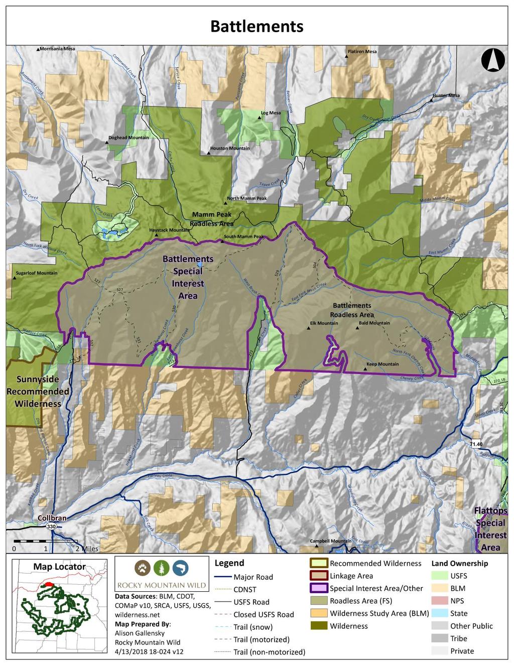
5 Battlements Special Interest Area Proposed Designated Area Grand Mesa National Forest Grand Valley Ranger District 24,000 acres General Description The Battlements SIA is located six miles north of the Town of Collbran in Mesa County. It is situated on the south side of Battlement Mesa, sandwiched between the Mamm Peak Inventoried Roadless Area on the White River National Forest and the Plateau Creek Valley. The area s steep and rugged terrain supports a diversity of vegetation and an array of wildlife, including large numbers of mule deer, elk and bear. Elevations in the area range from 7,500 to 11,000. Because of its important wildlife habitat and opportunities for solitude in within an area that is seeing increased oil and gas development, it should be protected as an SIA that protects those values from development. Naturalness The area is characterized by steep terrain on the south side that is largely forested. On the north side, at the top of Battlement Mesa, the forest is interspersed with open meadows and wetlands. The Battlements possesses a remote and wild character, and it retains a high degree of naturalness. There is a trail system that is open to some kinds of motorized use, and there is some water infrastructure in the area. Nonetheless, the area remains predominantly undeveloped and natural in appearance. Outstanding Opportunities for Solitude or Unconfined Primitive Recreation The area s trails mostly follow drainages up the steep slopes on the north side of Battlement Mesa to the top. These trails are well separated from each other by distance and topography. On top there is one trail that traverses the length of the Mesa and travels in and out of forested stands and open meadows. The chances of encountering other visitors in this area are slim, and the terrain and vegetation generally preserve outstanding opportunities for solitude and unconfined primitive recreation throughout the area.
6 Use of the area is low. It is busiest during the hunting season. There is also some snowmobile use in the winter. However, visitors to the area are unlikely to encounter others. Size and Roadlessness Battlement Mesa is a dramatic, 20-mile long, east-west ridge that divides Plateau Creek from the Colorado River. The 24,400-acre Battlements Roadless Area is just one piece of a roadless complex that spans the length of Battlement Mesa (including the Sunnyside, Housetop and Mamm Peak Roadless Areas), and it is proximate to a host of other roadless areas that continue east to the Crystal River and the Maroon Bells Snowmass Wilderness Area. This is an important piece of roadless land in the midst of a much greater network that provides important east-west and north-south connectivity for migrating wildlife. Supplemental Values The eastern edge lies within the Battlement Mesa lynx linkage area and higher elevation areas are mapped as lynx denning and other habitat. McCurry Reservoir and Brush Creek, Hawxhurst Creek, Kimball Creek and Smalley Creek all support Colorado River cutthroat trout. The Gambel oak intermixed with aspen provides habitat for sensitive species like Lewis woodpecker. The whole area provides important wildlife habitat. The Dry Fork Kimball Creek Potential Conservation Area (PCA) overlaps the western edge of the Battlements Roadless Area and has been identified for protection due to the presence of three rare plants, two of which have known occurrences (Lesquerella parviflora and Argillochloa dasyclada). Manageability The boundaries for this area are well defined by private land to the south, the White River National Forest to the north and Kimball and Middleton Creeks to the west and east. Because of limited public access, continued management of the area to protect wildlife habitat and roadless character should present no problem. As the Colorado Department of Wildlife (now Parks and Wildlife) wrote in recommendations on the Colorado Roadless Rule: This highly productive [roadless area] should not be developed further with roads or trails and nonsystem roads should be obliterated. This [roadless area] supports strong populations of a variety of wildlife which can easily be displaced with greater disturbance from the construction or enhancement of roads. Continued management should emphasize protection of important existing habitat, as well as limited opportunities for backcountry recreation (including hunting and fishing). In addition, management of the Battlements SIA should include closure to new mineral leasing or, at the very least, a full NSO stipulation for any new oil and gas leases that overlap this area. This would protect the area s outstanding wildlife and recreation values.
7 Information Resources Item Data Source Roadlessness Naturalness; Outstanding Opportunities for Solitude or Unconfined Primitive Recreation Colorado Roadless Rule at 36 CFR xx Forest Service inventory pursuant to FSH ,chapter 70, section 71 Colorado Division of Wildlife NW Region, Comments on Grand Mesa National Forest Roadless Areas available at islandora/object/co:24707/datastream/obj/view Forest Service inventory pursuant to FSH ,chapter 70, section 72 USDA Forest Service, R2, Profiles of Colorado Roadless Areas 2008 GMUG Roadless Inventory & Evaluation for Potential Wilderness Areas, 2005 Supplemental Values Connectivity SREP Wildlands Network 2003, USDA Forest Service Southern Rockies Lynx Amendment, 2008 Aplet et al, Indicators of Wildness 2000, Belote et al, Identifying Corridors among Large Protected Areas in the United States, 2016 Boreal Toad Overall Range Elk Production Area Elk Winter Concentration Area Gunnison Sage-grouse Historic Habitat Lynx Potential Habitat Moose Concentration Area Moose Priority Habitat Dry Fork Kimball Creek Potential Conservation Area with Very High Biodiversity Significance Colorado Natural Heritage Program Potential Conservation Areas 2017
8 Beaver Creek at Battlement Mesa Potential Conservation Area with High Biodiversity Significance Colorado Natural Heritage Program Potential Conservation Areas 2017
9
10

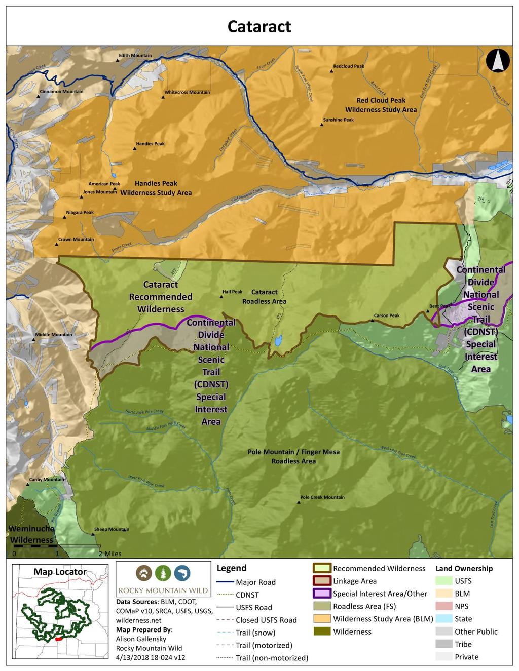
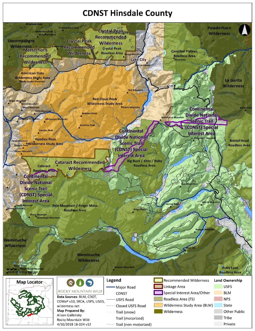
11 Cataract Recommended Wilderness Proposed Wilderness Designation Gunnison National Forest Gunnison Ranger District 10,000 acres General Description Cataract spans several glacial carved valleys at the headwaters of the Lake Fork of the Gunnison near Lake City. The area is precipitous and rugged, characterized by massive peaks and huge glaciated valleys dotted with waterfalls and moss-covered grottoes. The valleys access rolling tundra and high peaks in the core of the area. Cataract fills a key niche in a collection of adjacent roadless areas on either side of it: the BLM s recommended Handies Peak Wilderness adjoins the entire northern boundary of Cataract, and the Rio Grande National Forest s remarkable Pole Creek Mountain Roadless Area is contiguous along the south boundary. At 75,000 acres, the areas collectively comprise one of the largest unprotected roadless landscapes remaining in Colorado. Cataract completes the watershed protection for adjacent Handies Peak WSA by incorporating the headwaters of Cataract Gulch and Cuba Gulch. Cataract features several prominent recreation destinations. A half-dozen miles of the Continental Divide National Scenic Trail/Colorado Trail skirt the southern edge of the area and one of Colorado s 100 highest peaks, Half Peak, rises prominently in the area s center. System trails follow Cataract Gulch and Cuba Gulch from the floor of the Lake Fork valley to the crest of the Continental Divide. Naturalness Cataract s imposing geography and volcanic strata have combined to limit past human activities that might have marred the area s natural character. It has limited timber resources that preclude active management. Several patented mining claims occur in the lower reaches of Cuba Gulch, but these experienced little actual mining, are difficult to identify in the field, and are in the acquisition process. Cataract represents classic Colorado high country wilderness.
12 Outstanding Opportunities for Solitude or Unconfined Primitive Recreation Cataract is the central piece of one of Colorado s largest unprotected roadless landscapes, and not surprisingly visitors can easily find outstanding opportunities for solitude. The area s immense glaciated valleys enhance the sense of remoteness and isolation. Non-mechanized trails follow the two primary streams in the area, Cataract Gulch and Cuba Gulch, and these offer outstanding opportunities for unconfined primitive recreation. Both trails start at trailheads along Cottonwood Creek on adjacent BLM lands. Cataract Gulch trail switchbacks past roaring cascades as it winds its way above treeline to the Continental Divide. The more obscure Cuba Gulch trail similarly leads to the Divide and receives significantly less use. Summiting 13,841-foot Half Peak is a common focus for hikers along the Continental Divide National Scenic Trail, which skirts the entire southern boundary of the area. Size and Roadlessness Cataract by itself is 10,000 acres, matching the roadless boundaries identified as the Cataract CRA, and it includes Upper Tier roadless lands. It also abuts the BLM s 16,664-acre Handies Peak WSA to the north and the Rio Grande National Forest s 43,900-acre Pole Creek Mountain roadless area to the south. The area is free of any current or historic roads. Supplemental Values Cataract is important for several species of significant conservation concern. It is an area of high use by lynx and provides connections for lynx moving through the heart of the core population of the San Juan Mountains as part of the Silverton-Lake City lynx linkage recognized by the Forest Service. The area contains habitat utilized by the endangered Uncompahgre fritillary butterfly. Cataract includes a large portion of the Half Peak Potential Conservation Area identified by the Colorado Natural Heritage Program. The best known worldwide occurrence of stonecrop gilia is located in the Half Peak PCA along the southern edge of the proposed wilderness. This PCA is rated by CNHP as possessing B1-Outstanding Biodiversity Significance, its highest rating. The large roadless complex with Cataract at its center has the highest ecological connectivity value between the Rio Grande and Gunnison watersheds. This comes as little surprise given the undisturbed condition of the landscape and its location between large wilderness areas such as the Weminuche and Uncompahgre. Manageability Cataract has no conflicting uses that would compromise its manageability as wilderness. The only patented mining claims in the area, in Cuba Gulch, were in process of acquisition by the Forest Service in There are no unpatented mining claims, and no oil and gas potential. No active grazing occurs in the area. The trails are closed to motorized and mechanized uses. Cataract was recommended for wilderness in the draft 2007 Forest Plan.
13 Information Resources Item Data Source Roadlessness Naturalness; Outstanding Opportunities for Solitude or Unconfined Primitive Recreation Colorado Roadless Rule at 36 CFR xx Forest Service inventory pursuant to FSH ,chapter 70, section 71 Forest Service inventory pursuant to FSH ,chapter 70, section 72 USDA Forest Service, R2, Profiles of Colorado Roadless Areas 2008 GMUG Roadless Inventory & Evaluation for Potential Wilderness Areas, 2005 Supplemental Values Connectivity SREP Wildlands Network 2003, USDA Forest Service Southern Rockies Lynx Amendment, 2008 Aplet et al, Indicators of Wildness 2000, Belote et al, Identifying Corridors among Large Protected Areas in the United States, 2016 Bighorn Sheep Production Area Elk Production Area Lynx Potential Habitat Moose Concentration Area Half Peak Potential Conservation Area with Outstanding Biodiversity Significance Wager Gulch Potential Conservation Area with Very High Biodiversity Significance Colorado Natural Heritage Program Potential Conservation Areas 2017 Colorado Natural Heritage Program Potential Conservation Areas 2017
14
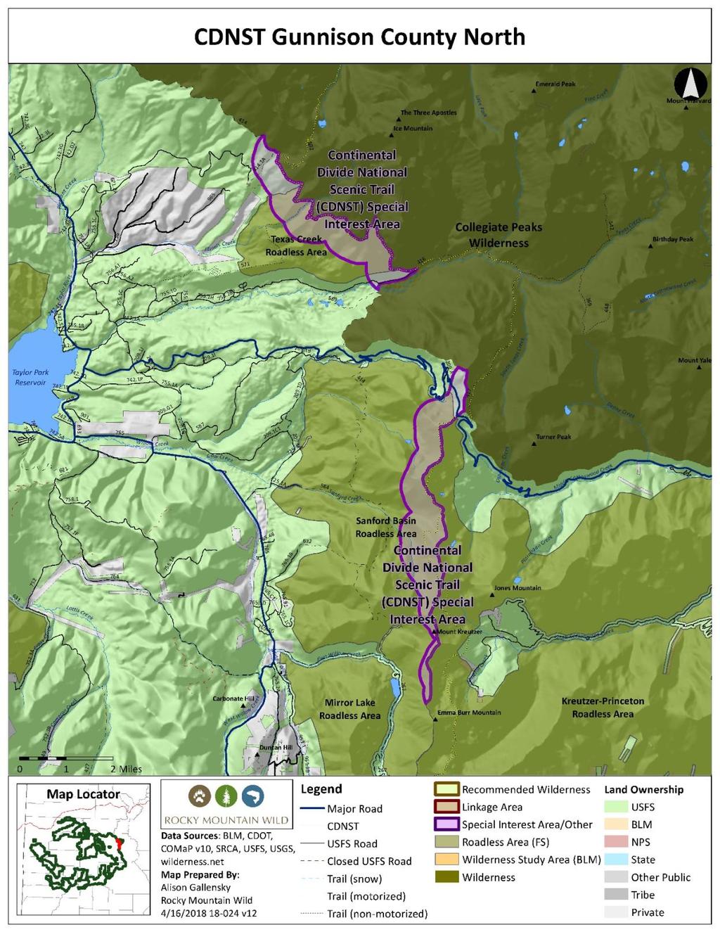
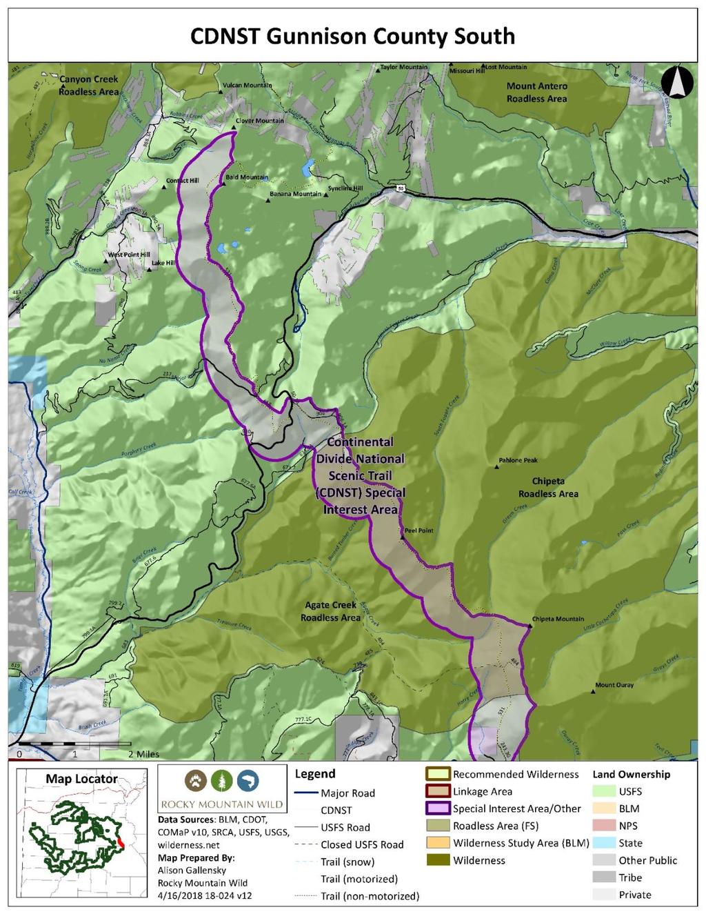
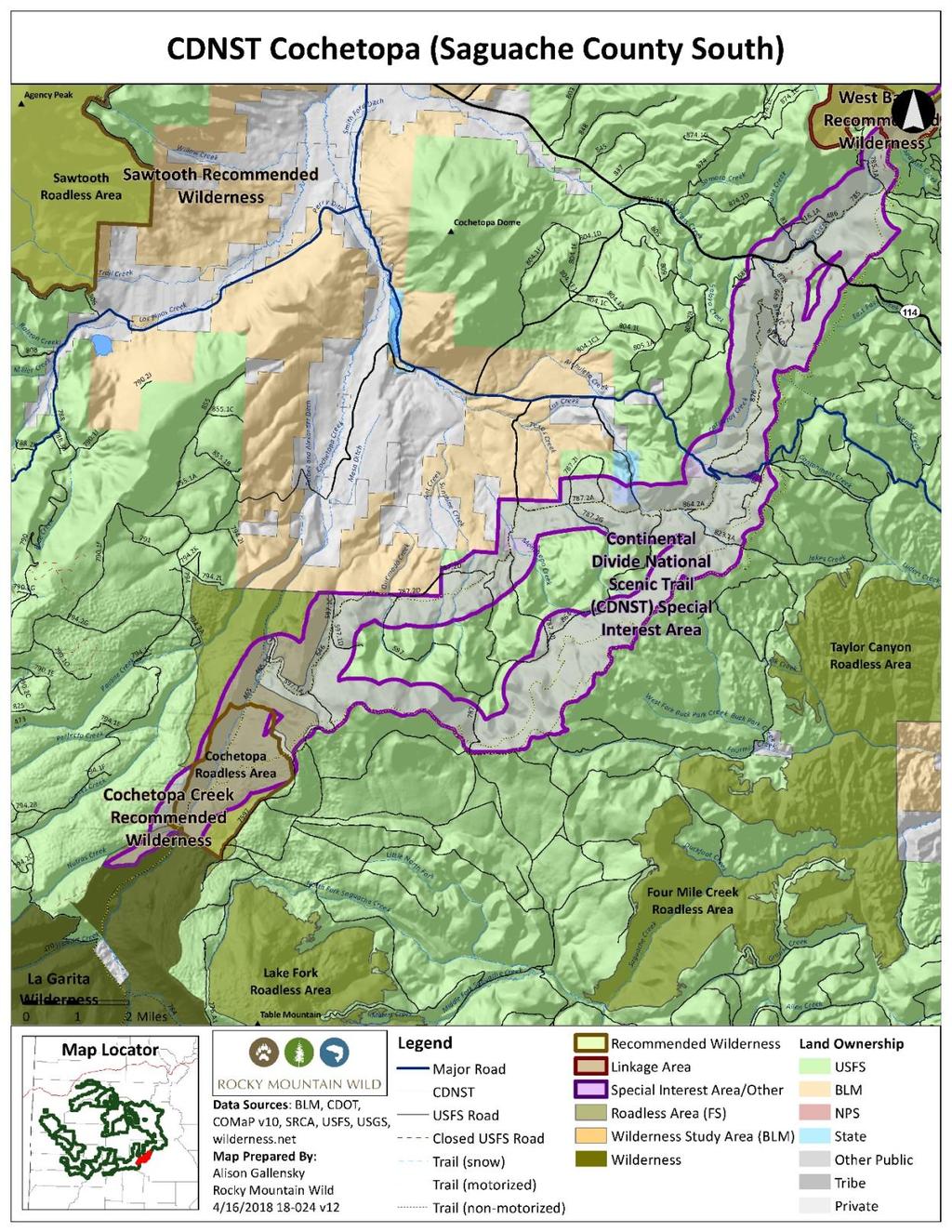
15 Continental Divide National Scenic Trail Special Interest Areas Proposed Special Management Designation Gunnison National Forest 47,000 acres The Continental Divide National Scenic Trail (CDNST) is a 3,100-mile continuous path that follows the spine of the Rocky Mountains from Mexico to Canada, traversing some of the most scenic and culturally-rich terrain in the country. The nature and purposes of the trail are to provide for high-quality, scenic and primitive hiking and horseback riding opportunities and to conserve the natural, historic and cultural resources along the CDNST corridor, per the Continental Divide Trail Comprehensive Plan approved by Forest Service Chief Tidwell in September The trail is to be managed to provide for its nature and purposes. Activities that would substantially interfere with the purposes for which the trail was designated should be avoided to the extent practicable. Approximately 130 miles of the CDNST are within lands managed by the GMUG, or within one half mile of the forest boundary, including segments in Gunnison, Saguache and Hinsdale Counties. We recommend that the revised Forest Plan identify and manage a minimum of a halfmile buffer from the trail to comply with recommended CDNST Plan components and statutory obligations. Managing this minimum half-mile buffer of the CDNST as an SIA in the revised forest plan would ensure that the minimum suggested desired conditions, objectives, standards and guidelines identified in the CDNST Recommended Forest Plan Components document from August 30, 2016 are met. We recommend that the GMUG consider additional plan components, and adjust these listed components accordingly, to suit the unique conditions found on segments of the CDNST including some of the most remote, isolated and minimally used sections of this trail in Colorado. We will submit additional recommendations at a later date. In addition, management in the revised forest plan that achieves those objectives would also contribute to the protection and conservation of the outstanding wildlife and wildlife habitat found on the GMUG within a half-mile of the trail, detailed in the table below. Supplemental Wildlife Values Bighorn Sheep Production Area Boreal Toad Overall Range Elk Production Area Gunnison Sage-grouse Historic Habitat Data Source
16 Gunnison Sage-grouse Overall Range Gunnison Sage-grouse Production Area Lynx Potential Habitat Moose Concentration Area Moose Priority Habitat Middle and South Cottonwood Creeks Potential Conservation Area with Outstanding Biodiversity Significance Cottonwood Pass Potential Conservation Area with High Biodiversity Significance Spout Lake Potential Conservation Area with High Biodiversity Significance Whitepine Iron Fen Potential Conservation Area with Very High Biodiversity Significance Monarch Pass Potential Conservation Area with High Biodiversity Significance Little Cochetopa Creek Potential Conservation Area with Moderate Biodiversity Significance Half Peak Potential Conservation Area with Outstanding Biodiversity Significance Little Cochetopa Creek Potential Conservation Area with Moderate Biodiversity Significance Gunnison Basin Potential Conservation Area with Outstanding Biodiversity Significance Identified Cottonwood/Tincup, Poncha Pass, North Pass/Cochetopa Hills, Slumgullion/Spring Creek Pass, Lynx Linkage Areas Colorado Natural Heritage Program Potential Conservation Areas 2017 Colorado Natural Heritage Program Potential Conservation Areas 2017 Colorado Natural Heritage Program Potential Conservation Areas 2017 Colorado Natural Heritage Program Potential Conservation Areas 2017 Colorado Natural Heritage Program Potential Conservation Areas 2017 Colorado Natural Heritage Program Potential Conservation Areas 2017 Colorado Natural Heritage Program Potential Conservation Areas 2017 Colorado Natural Heritage Program Potential Conservation Areas 2017 Colorado Natural Heritage Program Potential Conservation Areas 2017
17
18
19
20
21

22 Chalk Mountain Recommended Wilderness Proposed Wilderness Designation Gunnison/Grand Mesa National Forests Paonia/Grand Valley Ranger District 8,200 acres General Description The Chalk Mountain recommended wilderness is located in both the Gunnison and Grand Mesa National Forests, straddling the Delta-Mesa county line. Much of the proposed wilderness area consists of Chalk Mountain and its surrounding slopes and drainages. Chalk Mountain offers diverse ecosystems, in large part due to its topographic variety, ranging from below 9,000 feet up to 11,146 feet at Chalk Mountain, the most prominent feature in this unit. On the eastern face of Chalk Mountain, a large slump exposes very well defined sandstone and shale bedding of the Tertiary Green River Formation. The ecology of this area consists of aspen forests mixing into spruce-fir conifer forests, with large open park meadows that offer wetlands, beaver ponds, and a number of creeks that traverse or begin in this unit, including Buzzard Creek, Willow Creek, Dyke Creek, and West Muddy Creek. The Chalk Mountain unit is adjacent to the 21,00-acre Elk Park recommended wilderness located to the south, separated by just an over snow motorized route. Chalk Mountain represents the northern and easternmost unit of the Elk Park complex a recommended wilderness and special interest area complex totaling 55,300 acres in the Grand Mesa and Gunnison National Forests, separated by just two motorized routes and an over the snow route. Much of the remainder of the unit boundary is buffered (100 feet) by designated motorized routes, including the Buzzard Park Trail USFS 519 to the north and Monument Trail USFS 518 to the west. There were minimal signs of illegal motorized use, none recent, observed entering into the Chalk Mountain recommended wilderness from these boundary routes, despite many opportunities to traverse the interior park areas. The area is also buffered by Buzzard, Willow, and Dyke Creeks which prevent motorized use. Naturalness The Chalk Mountain recommended wilderness is primarily affected by the forces of nature. Dense old-growth aspen forests dominate in the lower elevation areas, which mix in with and eventually give way to subalpine spruce-fir forests at higher
23 elevations. Large open park meadows, with wetland areas, creeks, ponds, and riparian foliage, provide a haven for local wildlife. Few human impacts or infrastructure were observed within the unit. A grazing test area was observed in the northern section of the recommended wilderness, as well as a handful of cattle, however evidence of cattle was minimal and restricted to the lower elevation portions of the unit. It is also worth noting that there were very few noxious weeds observed in the recommended wilderness. The only obvious sign of human activity observed within the area was a wide zigzag swath of cleared trees extending from near the summit of Chalk Mountain down the slope to the northeast. No vehicle tracks or electrical lines were apparent in this swath from an aerial observation. Outstanding Opportunities for Solitude or Unconfined Primitive Recreation Chalk Mountain offers numerous opportunities for solitude and unconfined primitive recreation. The lack of interior trail infrastructure, along with vegetative screening from the dense aspen and conifer forests, provide outstanding opportunities for solitude and respite. This area s richness of wildlife and habitat offer excellent opportunities for primitive recreation, most notably for backcountry hunting in the fall, but also wildlife viewing and photography. Hunters on ATVs were observed scouting the Buzzard Park area for signs of wildlife along the USFS 519, which buffers the recommended wilderness s northern boundary. Size and Roadlessness The Chalk Mountain proposed wilderness addition is 8,200 acres and adjacent to the north of the 21,000-acre Elk Park recommended wilderness, separated by an over the snow motorized route. There are no roads within the Chalk Mountain unit. Supplemental Values The Chalk Mountain unit is particularly important for elk as it provides overall elk summer range, and summer concentration in the lower elevation areas in the northern and western sections of the unit. The northern section of the unit that comprises Buzzard Creek is also an important elk production area. Signs of other big game animals have also been observed within the unit, including mule deer and moose. Bald eagles have been observed in the southern section of the proposed wilderness, and CPW recognizes the southeast portion as potential nesting for the peregrine falcon, a CPW endangered species. This unit is also contiguous to valuable nesting habitat for martin and other nesting birds in the Mule Park and Hubbard Park areas. The Chalk Mountain area, as part of the greater Elk Park complex in this region of the GMUG National Forest, represents one of the largest opportunities within the GMUG National Forest to expand representation of aspen within the wilderness system. About one-third of this area is comprised of ecosystem types with less than 20 percent representation at the forest level. These include Rocky Mountain Aspen Forest and Woodland, Rocky Mountain Subalpine- Montane
24 Mesic Meadow, and Southern Rocky Mountain Montane-Subalpine Grassland, for which there exists less than 20 percent representation in existing wilderness at the forest and federal level. Dyke Creek, with headwaters in the southern portion of the Chalk Mountain unit, has conservation populations of Greenback cutthroat trout. These are located in streams with the highest watershed integrity class. Portions of the Chalk Mountain recommended wilderness also provide outstanding scenic values of the North Fork Valley below to the south, and of the West Elk Mountains and Ragged Mountains to the south and southeast. Manageability Chalk Mountain would be easily managed as wilderness. Identifiable features outline the boundary in the form of motorized trails and a power line to the east. The opportunity for unauthorized motorized trespass is available, but there is minimal evidence that this is currently taking place. There are no cherry-stem roads or other intrusions that enter this compact unit. Information Resources Item Data Source Roadlessness Naturalness; Outstanding Opportunities for Solitude or Unconfined Primitive Recreation Supplemental Values Boreal Toad Overall Range Colorado Roadless Rule at 36 CFR xx Forest Service inventory pursuant to FSH ,chapter 70, section 71 Forest Service inventory pursuant to FSH ,chapter 70, section 72 USDA Forest Service, R2, Profiles of Colorado Roadless Areas 2008 GMUG Roadless Inventory & Evaluation for Potential Wilderness Areas, 2005 Elk Production Area Lynx Potential Habitat Moose Concentration Area Moose Priority Habitat Cutthroat Trout GMUG NF Cutthroat Trout Species and Conservation Assessment, 2011 Ecosystem Representation TWS Ecosystem Representation 2016
25

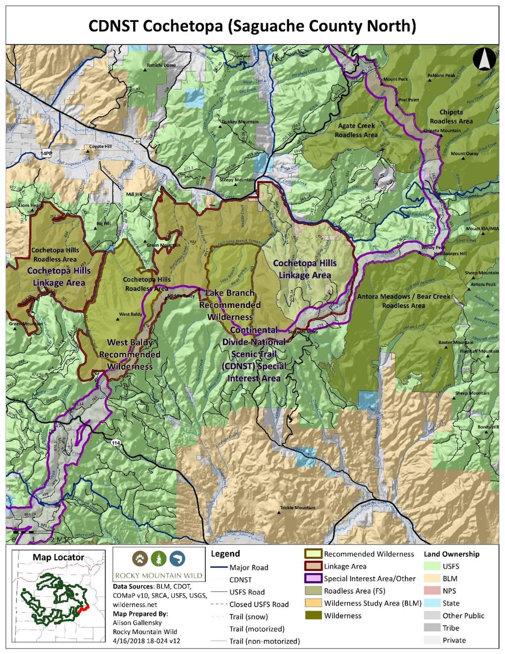
26 Cochetopa Hills Linkage Area Proposed Special Management Designation Gunnison National Forest 46,000 acres Cochetopa Hills Linkage Area consists of 46,000 acres of lower tier roadless lands and adjacent forested lands surrounding the proposed West Baldy and Lake Branch wilderness areas. Outside of the two proposed wilderness areas, the western two-thirds of the Cochetopa Hills Linkage Area overlaps with the Cochetopa Hills CRA, while the eastern third extends from the roadless boundary to Tank Seven Creek. This large roadless and wildlands complex represents a tremendous opportunity to enhance wildlife protection on a critical low point along the Continental Divide. Very little of the Cochetopa Hills is above timberline, despite the dozen miles of the Continental Divide that winds through the area. The lowest slopes consist of rolling grassland. Forests of lodgepole pine and Douglas fir blanket the higher slopes, often interrupted by meadows banded by aspen groves. Near the divide, Engelmann spruce and subalpine fir take hold; alpine tundra makes only the briefest appearance. In high-elevation areas, many isolated and lovely parks welcome hikers. The Continental Divide National Scenic Trail/Colorado Trail segment running through Cochetopa Hills is one of the most lightly visited, hiked mainly by those intending to traverse the entire length of the trail from Denver to Durango. Cochetopa Hills is an important regional wildlife corridor between the Rio Grande/San Juan Basin to the south, and the Gunnison Basin to the north. One of the lowest points on the Continental Divide in Colorado, Cochetopa Hills is a natural crossing point for many wildlife species in and out of the Gunnison Basin, and forms an important ecological link from the La Garitas to the west, and towards Fossil Ridge to the north. The area has been especially noted as a well-used trans-basin lynx crossing point within the important North Pass/Cochetopa Hills lynx linkage corridor. (USDA Forest Service Southern Rockies Lynx Amendment, 2008). Cochetopa Hills should be managed as a Linkage Area that focuses on wildlife and connectivity.
27 Supplemental Values Elk Production Area Elk Winter Concentration Area Gunnison Sage-grouse Historical Habitat Gunnison Sage-grouse Overall Range Gunnison Sage-grouse Production Area Lynx Potential Habitat Gunnison Basin Potential Conservation Area with Outstanding Biodiversity Significance Data Source Colorado Natural Heritage Program Element Occurrences 2017
28
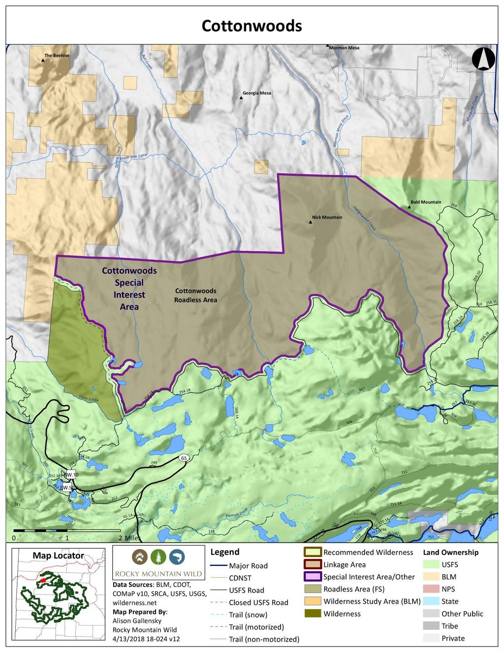
29 Cottonwoods Special Interest Area Proposed Designated Area Grand Mesa National Forest Grand Valley Ranger District 10,000 acres General Description Cottonwoods is on the north side of Grand Mesa, approximately eight miles southwest of Collbran. The southern boundary is bound by USFS Road 254.1A, and the GMUG s border with private land marks the northern boundary. To the west, the area is bounded by USFS motorized trail #511. Cottonwoods is contiguous with the popular Grand Mesa National Forest recreational area known as the Cottonwood Lakes. The area is notable for its variety of vegetation, ranging from fens, ponds and lakes to a spruce-fir-aspen mix. Several beautiful perennial creeks run through this area, including Bull Creek, Cottonwood Creek and Spring Creek.. Naturalness The area possesses wild character and retains a high degree of naturalness. The southern half is notable for its large concentration of fens, wetlands, lakes and associated species. A robust mix of wildlife are present in this area, including black bear, bobcat, deer, elk, mountain lion, mule deer and wild turkey. Outstanding Opportunities for Solitude or Unconfined Primitive Recreation While the area is accessible by trails to the west and south, it generally does not receive very much recreation use in the summer. Once away from these access points, one finds solitude. Size and Roadlessness Cottonwoods 10,000 acres largely overlap with the Cottonwoods CRA. Manageability We recommend against further road development and/or reconstruction in this area in order to maintain and protect wildlife and habitat. Further, eliminating and reclaiming existing nonsystem roads and trails within the area would increase wildlife values and aid in keeping big game species on public lands as opposed to private lands where often they are not welcome. We recommend the area be closed to mineral leasing (at a minimum non-waivable NSO) and timber production, and managed to protect and enhance existing habitat, backcountry recreation opportunities, and clean water. Information Resources Item Data Source
30 Roadlessness Naturalness; Outstanding Opportunities for Solitude or Unconfined Primitive Recreation Supplemental Values Elk Production Area Gunnison Sage-grouse Historic Habitat Lynx Potential Habitat Moose Concentration Area Moose Priority Habitat Mule Deer Winter Concentration Area Pine Park Reservoir Potential Conservation Area with Very High Biodiversity Significance Grand Mesa Lakes Potential Conservation Area with Moderate Biodiversity Significance Colorado Roadless Rule at 36 CFR xx Forest Service inventory pursuant to FSH ,chapter 70, section 71 Forest Service inventory pursuant to FSH ,chapter 70, section 72 USDA Forest Service, R2, Profiles of Colorado Roadless Areas 2008 Colorado Natural Heritage Program Potential Conservation Areas 2017 Colorado Natural Heritage Program Potential Conservation Areas 2017
31

32 Currant Creek Special Interest Area Proposed Designated Area Grand Mesa National Forest Grand Valley Ranger District 11,000 acres General Description The Currant Creek proposed special interest area is in the Grand Mesa National Forest. Currant Creek represents the southern and westernmost unit of the Elk Park complex a combination of recommended wilderness and special interest areas totaling 55,300 acres in the Grand Mesa and Gunnison National Forests, separated by just two motorized routes and an over-the-snow route. The Currant Creek unit lies on the southern flank of Grand Mesa with the long dimension oriented east-west, parallel to the long dimension of the mesa. The northern boundary is defined by the Green Mountain ATV trail (USFS 719), and the parcel slopes about four miles down from there to the Grand Mesa National Forest boundary. Green Mountain summit (10,802 feet) lies just outside the northeastern corner of the area. The southern and western boundaries are primarily defined by private property, with some BLM-managed land to the southwest. Currant Creek is the most prominent feature in this unit, flowing north-south right down the center. Other creeks and drainages also are present and flow through this unit, all in a similar north-south direction. Beaver ponds are abundant in the western portion of the unit, along Beaver Creek. The foliage consists of aspen and conifer mixed forests at the higher elevations in the northern section of the unit, which give way to some open meadows as well as steep, rocky cliffs. Oak scrublands predominate in the southern portion of this unit. Naturalness The Currant Creek area is primarily affected by the forces of nature, as much of the unit appears natural and healthy. Roads, trails and structures are common along the eastern, western and southern boundaries of the unit. However, these human impacts, including the Patterson Reservoirs and infrastructure just to the southeast of the unit, have been excluded from the unit. The northern boundary is buffered by the Green Mountain USFS Trail 719, however no illegal intrusion into the unit was observed. From an aerial perspective, a narrow, linear track was observed extending southward
33 along an extended line from the Green Mountain summit into the unit. No vehicle track or electricity lines were apparent on or near this linear feature. Outstanding Opportunities for Solitude or Unconfined Primitive Recreation The Currant Creek unit, mostly covered by dense aspen forests, mixed forests and oak scrublands, along with few interior trails, provides outstanding opportunities for solitude and remoteness. There are also many outstanding opportunities for primitive recreation in this area, including hiking, hunting, wildlife viewing, photography and scenic viewing. The big game populations in this region, particularly deer and elk, make this area ideal for backcountry sportsmen. Size and Roadlessness The Currant Creek special interest area is 11,000 acres. It is part of the greater 55,300 Elk Park complex on Grand Mesa, which consists of four units separated by just three linear features. There are no roads within the Currant Creek unit. Supplemental Values This unit provides important elk and deer calving and fawning grounds, and extends down into winter range of the North Fork Valley. Signs of other animals were observed within this unit, including black bear and coyote. Much of the non-forested sections of the Currant Creek area also provide outstanding scenic values of the North Fork Valley below to the south, the West Elk Mountains across the valley, and the Uncompahgre and San Juan Mountains to the south and west. Manageability The Currant Creek SIA overlaps with the lower tier Currant Creek CRA. The Currant Creek unit is bounded by the motorized Green Mountain trail on the north and the forest boundary on the south and west. Existing oil and gas leases along the periphery of the area are excluded. Information Resources Item Roadlessness Naturalness; Outstanding Opportunities for Solitude or Unconfined Primitive Recreation Data Source Colorado Roadless Rule at 36 CFR xx Forest Service inventory pursuant to FSH ,chapter 70, section 71 Forest Service inventory pursuant to FSH ,chapter 70, section 72 USDA Forest Service, R2, Profiles of Colorado Roadless Areas 2008
34 Supplemental Values Elk Production Area GMUG Roadless Inventory & Evaluation for Potential Wilderness Areas, 2005 Elk Winter Concentration Area Lynx Potential Habitat Moose Priority Habitat Mule Deer Winter Concentration Area Ecosystem Representation TWS Ecosystem Representation 2016
35


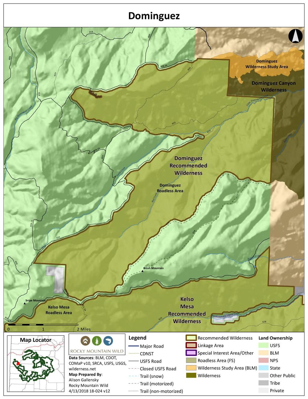
36 Dominguez Recommended Wilderness Proposed Wilderness Designation Uncompahgre National Forest Grand Valley Ranger District 13,000 acres General Description Dominguez consists of the upper headwaters of Little Dominguez Canyon, where Keith Creek and Red Creek combine to form Little Dominguez Creek. It encompasses the upstream watershed of the adjacent portion of BLM s Dominguez Canyon Wilderness. The proposed national forest wilderness creates a topographically defined boundary for the Dominguez Canyon Wilderness that will be apparent on the ground to visitors and managers. Congress and wilderness advocates contemplated including Dominguez Roadless Area in the 2009 BLM wilderness designation, but deferred action at the Forest Service s request pending the GMUG Forest Plan revision and promulgation of the 2012 Colorado Roadless Rule. Dominguez is characterized most dramatically by Wingate sandstone canyon walls that line the 200-foot deep Little Dominguez Canyon and its upper tributaries. Pinyon-juniper, scattered ponderosa pine and oak woodlands cover the mesas, while the canyon floor is dominated by pinyon-juniper and narrowleaf cottonwood. Scattered, massive ponderosa pines four feet or greater in diameter occur throughout the canyon bottom. Both Keith Creek and Red Creek have substantial perennial flows, and below their confluence Little Dominguez Creek creates a dense riparian thicket of willow, rose, and oak. The creek sculpts polished bowls where it plunges over the Precambrian granite bedrock typical of the Uncompahgre Plateau basement rock. Along with its neighboring Kelso Mesa Roadless Area, Dominguez helps complete the landscape protection for the adjacent BLM National Conservation Area. Dominguez is comprised almost entirely of ecosystem types with scant representation within existing designated wilderness. It also provides entry to classic Colorado Plateau hiking opportunities beneath soaring sandstone canyon walls and along gurgling desert streams. Naturalness The heart of Dominguez consists of the two tributaries, Keith Creek and Red Creek, which descend from the Uncompahgre Plateau and quickly incise deep canyons. Precipitous rims of Wingate sandstone define much of the
37 length of these canyons and have precluded roads or other impairing developments. The Black Point Trail follows a dugway likely constructed into the cliff face for cattle access into Little Dominguez Canyon, but is impassable other than by foot or horse. Trails on the benchland north of Keith Creek were once constructed vehicle routes but are now closed to motorized travel. Some areas along the periphery of the roadless area have been terraced for range management purposes. The overall character of Dominguez is one where human imprints are substantially unnoticeable. Outstanding Opportunities for Solitude or Unconfined Primitive Recreation Dominguez encompasses the uppermost reaches of remote Little Dominguez Canyon. The canyon receives little use originating from the lower end on BLM owing to the dense vegetation in the stream corridor, and similarly few hikers appear to drop into the canyon above from Black Point. The narrow, deep confines of Keith Creek, Red Creek and their combined Little Dominguez Canyon isolate visitors from all outside sights and sounds. The sweeping view from solitary sandstone outcrops on Black Point takes in the entire length of Little Dominguez Canyon, framed by the Grand Mesa in the far distance. The vista creates an overwhelming sense of isolation. Several trails offer outstanding opportunities for hiking and horseback riding. The Black Point trail was perhaps constructed originally as a cattle driveway off the end of the mesa into the upper reaches of Little Dominguez Creek, but it is located at the end of nine miles of two-track 4WD routes and thus provides outstanding solitude. The trail offers easy and direct access into the heart of the roadless area. Two other trails -- the Badland Trail and Winter Camp Trail -- create a loop, skirting the canyon rim and ridge north of Keith Creek. The Winter Camp Trail continues onward to enter the adjacent Dominguez Canyon Wilderness, and can also be accessed at a BLM wilderness trailhead in Wagon Park. All trails are closed to motorized and mechanized recreation. Size and Roadlessness Dominguez is a 12,500-acre area adjacent to BLM s 66,280-acre Dominguez Canyon Wilderness. The boundary is defined by grazing and hunter access 4WD roads, including the Black Point Road, Dominguez Road, and Buck Springs Road. The area s eastern boundary is contiguous with the Dominguez-Escalante National Conservation Area managed by BLM. Supplemental Values BLM found Little Dominguez Creek immediately adjacent downstream as eligible for wild and scenic river designation for its outstandingly remarkable scenic, geologic, wildlife and cultural values. These same features occur in the proposed Dominguez Wilderness on the upstream national forest. Scenic values include the creek, riparian vegetation and slick-rock canyon features. The geologic values consist of the Great Unconformity, a large gap in rock ages where the Precambrian basement rock is overlaid by much more recent Chinle formation. The occurrence of the canyon tree frog (Hyla arenicolor) is representative of the wildlife values, and the cultural values consist of evidence of 2,000 years of human activity.
38 Dominguez consists almost entirely of gambel oak and pinyon-juniper woodland ecosystem types. As a result, over 90 percent of Dominguez is comprised of ecosystem types with less than five percent representation within existing designated wilderness both at the federal level and at the individual forest level. These poorly represented ecosystem types are primarily Rocky Mountain Gambel Oak-Mixed Montane Shrubland and Colorado Plateau Pinyon-Juniper Woodland. Dominguez enhances connectivity across a larger landscape by completing protection for the headwaters of Little Dominguez Canyon, one of the significant watersheds within the adjacent downstream BLM Dominguez-Escalante National Conservation Area and Dominguez Canyon Wilderness. Dominguez and its neighboring Kelso Mesa Roadless Area encompass most of the uplands bordering the National Conservation Area. Dominguez offers the opportunity for crossjurisdictional management cooperation between the Forest Service and BLM to protect one of the largest, wildest landscapes in the upper Colorado Plateau. Manageability Dominguez is well-defined by roads and watershed divides. The eastern boundary abuts BLM s Dominguez-Escalante National Conservation Area. The area s primary wilderness feature consists of the deep canyons cut by Keith Creek, Red Creek and Little Dominguez Creek, all of which are protected by imposing canyon rims that preclude incompatible intrusions. There are no oil and gas leases within the area and no potential for oil and gas resources. There is no evidence of unauthorized motorized trespass into the roadless area off existing designated motorized routes that define the boundary. Information Resources Item Data Source Roadlessness Naturalness; Outstanding Opportunities for Solitude or Unconfined Primitive Recreation Colorado Roadless Rule at 36 CFR xx Forest Service inventory pursuant to FSH ,chapter 70, section 71 Forest Service inventory pursuant to FSH ,chapter 70, section 72 USDA Forest Service, R2, Profiles of Colorado Roadless Areas 2008 Supplemental Values Connectivity SREP Wildlands Network 2003, Aplet et al Indicators of Wildness 2000 Wild and Scenic River Eligibility Elk Production Area Elk Severe Winter Range Dominguez-Escalante NCA Summary Report for W&S River Eligibility, BLM, 2010
39 Elk Winter Concentration Area Gunnison Sage-grouse Historic Habitat Lynx Potential Habitat Mule Deer Winter Concentration Area Ecosystem Representation TWS Ecosystem Representation 2016
40


41 Electric Mountain Recommended Wilderness Proposed Wilderness Designation Gunnison National Forest Paonia Ranger District 9,700 acres General Description Electric Mountain is dominated by rolling aspen and spruce-fir forests that characterize the eastern end of Grand Mesa. It provides prime summer habitat for thriving herds of deer and elk, which in turn provide the primary recreational activity within the area during the fall hunting season. Electric Mountain offers outstanding opportunities for solitude because of its roadless and non-motorized management in a larger landscape dominated by motorized activities. Naturalness Electric Mountain is an undisturbed, forested ecosystem. The area s boundaries are defined by a high-voltage power line to the west, and by national forest system roads and the national forest boundary to the south. Some water diversion ditches occur along the area s northern periphery. The area has no existing or reclaimed roads and is entirely roadless. Outstanding Opportunities for Solitude or Unconfined Primitive Recreation The dense forest cover of Electric Mountain creates ideal circumstances for solitude and for unconfined and primitive recreation. The forest shields users from one another, and creates an immediate sense of seclusion when hikers or equestrians enter the area. Only one trail, the Terror Trail, crosses the area, almost exclusively used by foot and horse use. The predominant recreational use occurs during the fall hunting season as hunters who prefer a backcountry, non-motorized primitive hunting experience seek out the area. Outstanding features of the area are the sweeping views that span much of western Colorado. It feels extremely rugged and remote.
42 Size and Roadlessness Electric Mountain is 9,700 acres and overlaps the lower tier Electric Mountain CRA. It is free of any current or historic roads. It easily meets requirements for size and roadlessness. Supplemental Values The aspen ecosystem type that dominates Electric Mountain is underrepresented within the existing wilderness preservation system. About two-thirds of the Electric Mountain CRA consists of Rocky Mountain Aspen Forest and Woodland, of which accounts for less than 20 percent of existing wilderness at the forest and federal level. It is an important elk production area, contains summer range for deer and elk, and is a popular backcountry hunting area. It is also home to sensitive species that depend on the area s high elevation conifer and aspen forests. From this area, one can achieve outstanding views of the North Fork Valley, West Elk Mountains, and Ragged Mountains. Manageability Electric Mountain has readily identifiable features that define its boundary in the form of roads and powerlines. The area is a compact, oval shape without any significant cherry-stems or incompatible intrusions. No existing oil and gas leases significantly overlap the area, providing managers with leeway to administratively determine the area s potential for future energy development. The only trail through the area is closed to motorized use. Mechanized use is currently allowed on this trail, however, little to no mechanize use occurs, due to rugged terrain, a short season, and sheep grazing within the unit. Information Resources Item Data Source Roadlessness Naturalness; Outstanding Opportunities for Solitude or Unconfined Primitive Recreation Colorado Roadless Rule at 36 CFR xx Forest Service inventory pursuant to FSH ,chapter 70, section 71 Forest Service inventory pursuant to FSH ,chapter 70, section 72 USDA Forest Service, R2, Profiles of Colorado Roadless Areas 2008 GMUG Roadless Inventory & Evaluation for Potential Wilderness Areas, 2005 Supplemental Values Gunnison Sage-grouse Historic Habitat Lynx Potential Habitat Mapping Colorado 2017 Parks and Wildlife Species Activity Ecosystem Representation Mapping TWS Ecosystem 2017 Representation 2016

43

44 Elk Park Recommended Wilderness Proposed Wilderness Designation Gunnison/Grand Mesa National Forests Paonia/Grand Valley Ranger District 21,000 acres General Description The Elk Park proposed wilderness and greater roadless complex contains important wildlife habitat and is a critical watershed for municipal and agricultural users in the North Fork Valley. The area may have potential for oil and gas extraction, posing a fundamental decision about the future use of this large, undeveloped landscape whether to commit it to energy development or to preserve its value for wildlife and downstream water users. The area, if designated, would be the first wilderness area on the Grand Mesa, the last notable geographic feature in Colorado lacking any officially protected wilderness. Elk Park is dominated by extensive forests of aspen and spruce-fir, with numerous expansive meadows in a lush, wet environment. The area is characterized by its many wet meadows, springs, seeps, and wetlands, which contribute to a dependable water supply for farms, ranches and communities in the North Fork Valley. This unit is part of the greater Priest Mountain Elk Park complex consisting of recommended wilderness and special interest areas totaling 55,300 acres in the Grand Mesa and Gunnison National Forests, separated by just two motorized routes and an over-the-snow route. Naturalness Elk Park is the largest tract of undeveloped habitat on Grand Mesa. Boundaries have been drawn to exclude water resource facilities, motorized trails and power lines. There is a designated mechanical route that traverses the center of the unit, southwest of Overland Reservoir. This route receives very little use of any type due to the short summer season, and with much of trail waterlogged due to Overland Reservoir during the summer. The majority of use is most likely for hunting during the fall season. Outstanding Opportunities for Solitude
45 or Unconfined Primitive Recreation Elk Park is a large expanse of aspen and spruce-fir forest, interspersed with meadows. The dense forest cover, combined with its large extent, provides outstanding opportunities for solitude. Recreational visitors can quickly find themselves in remote and unvisited sections of the area. Trails and roads that provide ready access for exploring the interior by foot and horse define the area s boundaries. The area is used most intensively during the fall hunting season as hunters seeking a primitive, backcountry experience venture into the remote interior forests. Areas within this unit are used for cattle and sheep grazing. Size and Roadlessness Elk Park is located in one of Colorado s largest remaining roadless areas. The proposed wilderness covers 21,000 acres, with the 8,200-acre Chalk Mountain recommended wilderness to the north, separated by an over the snow route, and the 11,700-acre Priest Mountain Special Interest Area to the west, separated by an ATV route. There are no open roads within the area. An illegal motorized use trail was observed in the southern section of the unit off of the Overland Ditch road, which buffers the unit s southern boundary. This illegal use trail continues where a designated motorized route heads north along Sink Creek for a short distance to access water infrastructure, including pipes and an intake valve. This route has been excluded from the recommended wilderness as a cherrystem, however observations on the ground show that this route continues north into the unit. Supplemental Values Elk Park contains large tracts of aspen dominated ecosystems and grasslands, both of which are poorly represented within the existing wilderness preservation system. The Priest Mountain-Elk Park complex provides one of the largest opportunities within the GMUG National Forest to expand representation of aspen within the wilderness system. About one-third of the proposed wilderness is comprised of ecosystem types with less than 20 percent representation at the forest level. These include Rocky Mountain Aspen Forest and Woodland, Rocky Mountain Subalpine- Montane Mesic Meadow, and Southern Rocky Mountain Montane-Subalpine Grassland, for which there exists less than 20 percent representation in existing wilderness at the forest and federal level. The Elk Park unit in particular is an important elk production area. The entire complex of proposed wilderness units is valuable summer range for deer and elk, and the herds migrate through the roadless area to lower elevation winter range. Moose have also been observed in this unit. Sensitive species depend on these high elevation conifer, aspen, and riparian habitats that occur in this area, including the northern goshawk, boreal owl, flammulated owl, American martin, purple martin, and American three-toed woodpecker.
46 Main Hubbard Creek, Middle Hubbard Creek, and Cunningham Creek, all located in the southeastern portion of the unit, have conservation populations of Greenback cutthroat trout. The Hubbard Creek populations have less than one percent non-native genes. These are also located in streams with the highest watershed integrity class. There are outstanding views of the North Fork Valley, West Elk Mountains, and Ragged Mountains from within this area. Manageability The Elk Park recommended wilderness is located in a larger landscape with designated motorized routes, which were used to define the boundaries of this unit, along with some open meadows on the north and west boundaries that are likely used for winter recreation. With motorized use restricted to these designated routes, the surrounding densely-forested roadless areas should be manageable as wilderness. Water supply reservoirs are excluded from the area. The Elk Park unit is generally defined by the Sunlight to Powderhorn trail on the north, the Overland Ditch on the east and the motorized East Leon Trail to the west. Existing oil and gas leases along the periphery of the area are excluded. Information Resources Item Data Source Roadlessness Naturalness; Outstanding Opportunities for Solitude or Unconfined Primitive Recreation Supplemental Values Boreal Toad Overall Range Colorado Roadless Rule at 36 CFR xx Forest Service inventory pursuant to FSH ,chapter 70, section 71 Forest Service inventory pursuant to FSH ,chapter 70, section 72 USDA Forest Service, R2, Profiles of Colorado Roadless Areas 2008 GMUG Roadless Inventory & Evaluation for Potential Wilderness Areas, 2005 Elk Production Area Lynx Potential Habitat Moose Priority Habitat Cutthroat trout GMUG NF Cutthroat Trout species and conservation assessment, 2011 Ecosystem Representation TWS Ecosystem Representation 2016
47
48 Flattops Special Interest Area Proposed Designated Area Grand Mesa National Forest Grand Valley Ranger District 32,000 acres General Description Flattops should be managed to protect its outstanding wildlife, recreational and watershed values from oil and gas development. The area is contiguous to a large roadless complex to the south and east, and to national forest lands atop Grand Mesa to the west. Encompassing some of the highest parts of Grand Mesa, the Flattops area is important for its abundance of wildlife. Vegetation is predominantly spruce-fir and aspen with areas of mountain shrub, grassy meadows, and lush riparian habitat. There are numerous natural and manmade reservoirs in the area. Water from the area supports varied recreational use, agriculture, and domestic water supplies. Recreation, including hunting and fishing, backcountry hiking and biking, and OHV use are the dominant uses. Flattops is located south of Vega Reservoir in Mesa County. It is bounded to the west by the Park Creek Road #262, and the Buzzard Divide Road #265 in the east. In the south, the area is bounded by the watershed divide that separates Mesa and Delta Counties. Naturalness Flattops is part of the Flattops/Elk Park CRA, a 75,000-acre lower tier roadless complex spaning the Grand Mesa and Gunnison National Forests. The Flattops area possesses a remote and wild character, and it retains a high degree of naturalness. Aside from existing water developments that are located mostly on the southern edge of this unit, the area remains predominantly undeveloped and provides important wildlife habitat for various species. The area contains a few motorized trails, used mostly during hunting season, and the area is utilized by snowmobilers in the winter. These trails and uses, however, are spread out and don t generally diminish the area s natural character. Outstanding Opportunities for Solitude or Unconfined Primitive Recreation The motorized trails within the Flattop may diminish the sense of solitude and remoteness along those corridors, especially in open meadows that are common in the area s higher elevations. Once off these few trails, though, there remain outstanding opportunities for solitude. The meadows and interspersed forest in this area is unique in western Colorado and offers special opportunities for recreation. Size and Roadlessness This area encompasses a large swath of land between well-traveled roads and natural watershed boundaries. It is substantial in size and adjacent to several other roadless areas. There may be slight adjustments to the area that are appropriate to avoid existing reservoirs and access roads,
49 but those adjustments would be mostly along the area s existing boundaries and should not affect manageability of the vast majority of this area to protect existing natural values. Much of the area has a roadless character which is one reason wildlife is abundant. Roads and trails have been generally well placed to allow for access, yet the density is low enough so as not to be a negative influence on the wildlife. However, proliferation of non-system roads have always been a problem especially in the fall and commonly where snowmobile trails are marked and maintained all year long. Supplemental Values Encompassing some of the highest parts of Grand Mesa, Flattops is important for its abundance of wildlife. The area includes a broad range of summer habitats from large open meadows and spruce-fir pockets to expanses of aspen and mountain shrub. Riparian areas including wet seeps, springs, natural ponds and reservoirs, creeks and wetlands are common across a very large portion of the roadless area. Mule deer, elk, moose and many others species are found in the area. Black bear rely on the area, preferring elevations below 9,000 feet. Moose will spend the majority of the year here, concentrating on the lower elevations during the heavier snow months. According to Colorado Parks and Wildlife, this roadless area has many production areas for deer and elk where they also tend to raise their young until they migrate in the late fall. Boreal toad habitat is also abundant. Colorado River cutthroat trout populations occur in Park Creek and Willow Creek. Sensitive species dependent on high elevation conifer, aspen and riparian habitats occur in this area (Northern goshawk, boreal owl, flammulated owl, American martin, purple martin, American three-toed woodpecker). Flattops includes source waters for a municipal supply. Over 70 percent of this assessment area is managed by the Forest Service and recognized as having a high value for domestic water supply. Management Prescription Recommendations We recommend against further road development and/or reconstruction in this area in order to maintain and protect wildlife and habitat. Further, eliminating and reclaiming existing nonsystem roads and trails within the area would increase wildlife values and aid in keeping big game species on public lands as opposed to private lands where often they are not welcome. We recommend the area be closed to mineral leasing (at a minimum non-waivable NSO) and timber production, and managed to protect and enhance existing habitat, backcountry recreation opportunities, and clean water. Information Resources
50 Item Data Source Roadlessness Naturalness; Outstanding Opportunities for Solitude or Unconfined Primitive Recreation Supplemental Values Boreal Toad Overall Range Colorado Roadless Rule at 36 CFR xx Forest Service inventory pursuant to FSH ,chapter 70, section 71 Colorado Division of Wildlife NW Region, Comments on Grand Mesa National Forest Roadless Areas available at ora/object/co:24707/datastream/obj/view Forest Service inventory pursuant to FSH ,chapter 70, section 72 USDA Forest Service, R2, Profiles of Colorado Roadless Areas 2008 GMUG Roadless Inventory & Evaluation for Potential Wilderness Areas, 2005 Colorado Parks and Wildlife Species Activity Elk Production Area Colorado Parks and Wildlife Species Activity Gunnison Sage-grouse Historic Habitat Colorado Parks and Wildlife Species Activity Lynx Potential Habitat Colorado Parks and Wildlife Species Activity Moose Concentration Area Colorado Parks and Wildlife Species Activity Moose Priority Habitat Colorado Parks and Wildlife Species Activity Buzzard Creek Potential Conservation Area with Colorado Natural Heritage Program Very High Biodiversity Significance Potential Conservation Areas 2017 Vega Reservoir Potential Conservation Area with Colorado Natural Heritage Program Very High Biodiversity Significance Potential Conservation Areas 2017 Park Creek at Vega Reservoir Potential Colorado Natural Heritage Program Conservation Area with High Biodiversity Potential Conservation Areas 2017 Significance Ecosystem Representation TWS Ecosystem Representation 2016

51

52 Hayden Mountain Recommended Wilderness Proposed Wilderness Designation Uncompahgre National Forest Ouray Ranger District 10,000 acres General Description Hayden Mountain provides a breathtaking backdrop to the Million Dollar Highway, also known as the San Juan Skyway scenic byway. Hayden Mountain towers impressively above the west side of Highway 550 from Ouray to the summit of Red Mountain Pass. Hayden Mountain includes high snowcapped summits, quiet alpine basins, and sweeping aspen stands that erupt in riotous fall colors of orange, red and gold starting in September. The area s trails are a favorite destination of both local hikers and the many tourists who visit Ouray. Hayden Mountain sits squarely between the Uncompahgre Wilderness to the east and the Mount Sneffels Wilderness immediately to the west. It s in the heart of lynx habitat in the northern San Juan Mountains. Wilderness designation would plug a key gap in the system of wilderness areas that otherwise encircle Hayden Mountain on several sides. Hayden Mountain s roadless character, and associated wilderness values, has never been inventoried by the Forest Service. The area was omitted from the 1970s-era Roadless Area Review and Evaluations as it was within the Uncompahgre Primitive Area at the time, and was also never subsequently inventoried for analysis during the Colorado Roadless Rule process in the early 2000s. Naturalness

53 Hayden Mountain is an undeveloped range of seven high points including several 13,000-foot summits amidst one of Colorado s otherwise intensively mined landscapes. It towers above the Camp Bird mine to the west, and the Idarado mine to the south. The area s precipitous slopes precluded any substantial amount of surface disturbance that significantly impairs the area s overall naturalness. Some historic mining activities are apparent in the southern reaches of the area. Several mine dumps and an historic cabin remain at the Senator Beck mine, but the mine is dwarfed by the expansive landscape and beauty surrounding it. An automated weather station operated by the Center for Snow and Avalanche Studies is located in the basin of Senator Beck mine. Other mining relics dot the shoreline of Ptarmigan Lake, including an historic mine shack. A locked gate precludes motorized use of the historic jeep trail from Imogene Pass down to Ptarmigan Lake. These are similar historic structures to those found in the nearby Weminuche Wilderness in Chicago Basin, or in the Holy Cross Wilderness. The jeep roads to Barstow Mine and Greystone Mine along with the mine sites are excluded from the proposed wilderness. The jeep road between the mines and adjacent to Spirit Gulch is abandoned and undergoing natural revegetation and thus included within the proposed wilderness. Outstanding Opportunities for Solitude or Unconfined Primitive Recreation Hayden Mountain is classic, high alpine San Juan Mountain wilderness. The area s elevation provides sweeping vistas across rugged peaks and plunging valleys, reinforcing the sense of isolation and separation from civilization. The area is distant from signs of civilization, once away from the jeep trails that denote the boundaries along Black Bear Pass and Imogene Pass. Secluded alpine basins further enhance the area s outstanding opportunities for solitude. Hayden Mountain is a preferred destination in summer for hikers seeking vast alpine vistas, fields of alpine wildflowers, and snowfields hanging on late into summer. Backcountry skiers and boarders venture into the high basins and steep slopes in winter, and find the last pockets of snowfields late into spring. Several non-mechanized trails offer ready access for hikers, including the Hayden Mountain trail that traverses the northern end of the area. Historic pack trails lead to secluded locations such as Ptarmigan Lake and the alpine basin surrounding the long abandoned Senator Beck mine. Size and Roadlessness Hayden Mountain is 10,000 acres, and excludes open motorized routes that form its boundary, such as the jeep trails over Black Bear Pass and Imogene Pass. The motorized route
54 up Spirit Gulch to the Barstow Mine is also excluded from the proposed wilderness. Supplemental Values Hayden Mountain hosts abundant herds of elk in its high basins and alpine meadows during summer. It provides an important summer concentration area for elk and offers seclusion away from region s busier jeep trails. About one-half of the Colorado Natural Heritage Program s Mineral Basin Potential Conservation Area is located within the Hayden Mountain area. The PCA s vegetation is a mosaic of rocky alpine tundra and wet alpine meadows with high floral diversity dominated by alpine avens. Late melting snowbanks provide the necessary habitat for San Juan whitlow-grass (Draba graminea). Two other drabas are found in small amounts in drier, rocky sites. This PCA is rated by CNHP as possessing B2-Very High Biodiversity Significance. Hayden Mountain also bounds the Ironton Park PCA, identified for its uncommon iron fen and wetlands. This broad park occupies a level area where Red Mountain Creek has spread out into several channels, creating the largest wetland in the Uncompahgre Basin. Manageability Hayden Mountain is generally well protected from uses incompatible with wilderness by its terrain and topography. The trails are closed to motorized and mechanized uses. The area is generally bounded by Highway 550 to the east, Black Bear Pass jeep trail on the south, Imogene Pass jeep trail on the west, and the Canyon Creek road to the north. The designated motorized routes up to the Barstow Mine and Greyhound Mine are excluded from the proposed wilderness, and form a portion of the eastern boundary. Hayden Mountain s steep topography precludes winter motorized recreation. The area has no oil and gas potential. The Forest Service has acquired numerous patented mining claims from Idarado Mining Company and others, which removes the majority of the most desirable historic mineral veins from future location under the 1872 Mining Law. A number of patented mining claims remain within the area, but these have no historic vehicle access. The Forest Service continues to pursue acquisitions via land exchanges and purchases. Ouray County has strict zoning regulations that limit development on mining claims such as these in the alpine zone above 9,480 feet in elevation. Information Resources Item Roadlessness Naturalness; Outstanding Opportunities for Solitude or Unconfined Primitive Recreation Data Source Colorado Roadless Rule at 36 CFR xx Forest Service inventory pursuant to FSH ,chapter 70, section 71 Forest Service inventory pursuant to FSH ,chapter 70, section 72 USDA Forest Service, R2, Profiles of Colorado Roadless Areas 2008
55 GMUG Roadless Inventory & Evaluation for Potential Wilderness Areas, 2005 Supplemental Values Connectivity SREP Wildlands Network 2003, USDA Forest Service Southern Rockies Lynx Amendment, 2008 Aplet et al, Indicators of Wildness 2000, Belote et al, Identifying Corridors among Large Protected Areas in the United States, 2016 Lynx Potential Habitat Imogene Pass Potential Conservation Area with Very High Biodiversity Significance Colorado Natural Heritage Program Potential Conservation Areas 2017 Ironton Park Potential Conservation Area with Very High Biodiversity Significance Mineral Basin Potential Conservation Area with Very High Biodiversity Significance Ouray Canyons Potential Conservation Area with Very High Biodiversity Significance Colorado Natural Heritage Program Potential Conservation Areas 2017 Colorado Natural Heritage Program Potential Conservation Areas 2017 Colorado Natural Heritage Program Potential Conservation Areas 2017
56
57 Hightower Linkage Area Proposed Linkage Area Grand Mesa National Forest Grand Valley Ranger District 3,600 acres (Hightower East 800 acres; Hightower West 2,800 acres) General Description The Hightower Linkage Area, located on Grand Mesa, consists of two separate parts of the Hightower Roadless Area, approximately 17 miles east of Collbran. Its two units are separated by a private inholding, and both units are contiguous with the Reno Mountain Roadless Area on the White River National Forest. Hightower is within the Northern-Central Highlands and Rocky Mountain Eco-Section (M33IH) with elevations ranging from 8,000 to 9,700. This is not a large area, but it provides important connectivity in a chain of adjacent and nearly adjacent roadless areas stretching from the Grand and Battlement Mesas in the west all the way across the Crystal River and toward the main stem of the Rockies in the east. Hightower also sits along an important north-south corridor that connects the Colorado River Valley with the North Fork River Valley and the extensive wildlands south of there. Hightower Mountain at 9,555 feet and Reno Mountain at 9,741 feet are highpoints on the ridge that forms the northern boundary of this area and forms the western end of the Plateau Valley, north of the Grand Mesa. Hightower Creek in the Colorado River system has its headwaters in this area. Aspen forests predominate in this area with sagebrush steppes and gamble-oak at the lower elevations and small areas of spruce-fir near Hightower Mountain. Manageability The boundaries for this area are well defined by roads, trails and the National Forest boundary. There are two separate pieces of this Linkage Area, separated by an L shaped piece of private land. Nonetheless, both pieces are adjacent and contiguous with the Reno Mountain Roadless Area on the White River National Forest. There have been oil and gas leases located within this roadless area over the years. However, no oil and gas drilling has occurred within the roadless area. If the area remains open and available to leasing in the future, it can be protected by an NSO stipulation and minerals can be accessed under the area using directional drilling technologies. We recommend against further road development and/or reconstruction in this area in order to maintain and protect wildlife and habitat. Further, eliminating and reclaiming existing nonsystem roads and trails within the area would increase wildlife values and aid in keeping big game species on public lands as opposed to private lands where often they are not welcome. We recommend the area be designated as a Linkage Area, closed to mineral leasing and sales, and
58 timber production, and managed to protect and enhance existing habitat, backcountry recreation opportunities, and clean water. Information Resources Item Data Source Roadlessness Naturalness; Outstanding Opportunities for Solitude or Unconfined Primitive Recreation Colorado Roadless Rule at 36 CFR xx Forest Service inventory pursuant to FSH ,chapter 70, section 71 Forest Service inventory pursuant to FSH ,chapter 70, section 72 USDA Forest Service, R2, Profiles of Colorado Roadless Areas 2008 GMUG Roadless Inventory & Evaluation for Potential Wilderness Areas, 2005 Supplemental Values Connectivity SREP Wildlands Network 2003, USDA Forest Service Southern Rockies Lynx Amendment, 2008 Aplet et al, Indicators of Wildness 2000, Belote et al, Identifying Corridors among Large Protected Areas in the United States, 2016 Boreal Toad Overall Range Elk Production Area Elk Winter Concentration Area Lynx Potential Habitat Moose Concentration Area Moose Priority Habitat

59
 consists of craggy peaks, glaciated valleys and high alpine lakes.")
60 Hope Lake (Sheep Mountain) Special Interest Area Proposed Special Management Designation Uncompahgre National Forest Norwood Ranger District 11,000 acres General Description Hope Lake (also called Sheep Mountain) consists of craggy peaks, glaciated valleys and high alpine lakes. The area has been long recognized for its wilderness character, with citizen wilderness proposals dating to RARE II in the 1970s. Several incompatible activities in the form of heli-skiing and the use of Hope Lake as part of Excel Energy s Ames hydroelectric project preclude full-fledged wilderness designation. However, the area s outstanding wilderness character can be maintained through protective management as a backcountry special interest area. Federal legislation proposing a Sheep Mountain Special Management Area was first introduced to Congress in 2013 as part of the San Juan Mountains Wilderness Act. Hope Lake is part of a larger 70,000-acre roadless area that spans both the Uncompahgre and San Juan National Forests. It links Colorado s largest wilderness area, the Weminuche, with the nearby Lizard Head and Mount Sneffels wilderness areas to the west and north. Lynx confirm the significance of this landscape connection by utilizing the undeveloped corridor for movement across the San Juan Mountains. Hope Lake is free of significant modifications to its naturalness. Recent acquisitions in the Ophir Valley, facilitated by the Trust for Public Land, resulted in consolidation of several large blocks of patented mining claims on Yellow Mountain and along Waterfall Creek into public ownership, removing past and future threats of habitat-disturbing activities. Recreation Values Hope Lake is one of the largest undeveloped roadless areas in Colorado outside of wilderness. As in the case with other large, mountainous tracts, there are abundant opportunities to experience outstanding solitude. The popular Hope Lake Trail winds several miles to an alpine basin surrounded by colorful slopes and peaks. In addition to its namesake alpine lake and several scenic hiking trails, Hope
61 Lake offers challenges to mountaineers attempting to summit Pilot Knob, Golden Horn and South Lookout Peak, among the area s many difficult peaks. Biological Values Hope Lake incorporates the eastern half of the Lizard Head Pass lynx linkage, one of the key connections for lynx movement across the San Juan Mountains. This linkage area provides movement opportunities between blocks of habitat as well as maintaining permeability across Highway 145. Hope Lake takes in a portion of the Rolling Mountain Potential Conservation Area identified by the Colorado Natural Heritage Program, which encompasses high alpine basins with rocky slabs and thin gravelly soils. Areas where the snow lasts until late in the year are habitat for two rare mustard species, San Juan whitlow-grass (Draba graminea) and Colorado divide whitlow-grass (Draba streptobrachia). Boundary, Size and Access Hope Lake includes 11,000 acres on the Uncompahgre National Forest, but abuts an adjacent 60,000-acre roadless area on the San Juan National Forest. The area is generally bounded by the Ophir Valley on the north, and Trout Lake and Highway 145 to the west. The rest of the area adjoins roadless lands on the San Juan National Forest. Proposed Management Two existing uses within Hope Lake conflict with wilderness management and thus motivate this proposed alternative management. One is the Telluride Helitrax permit for heli-skiing, and the other is Excel s operation of Hope Lake as part of its Ames hydroelectric project. Consolidation of public ownership has removed a significant threat to maintaining the area s wilderness qualities, with acquisition by federal and local entities of 163 acres on Yellow Mountain and about 300 acres around Waterfall Creek in the northern portion of the area bounding the Ophir Valley. The terrain is not conducive to snowmobiling in winter. The Hope Lake Trail is nonmechanized, and the previous road up Swamp Canyon has been decommissioned and closed to motorized use. The area has low or no potential for oil and gas development. Recommended management direction in the Forest Plan includes: Hope Lake must be administratively unavailable for oil and gas leasing and mineral material sales, and a mineral withdrawal needs to be recommended for locatable minerals. Management direction must include a prohibition on timber harvest and new road construction. Hope Lake must be closed to winter motorized travel, and summer travel must be limited to non-mechanized activities. The area remains available for operation under the existing Helitrax heli-skiing permit. Excel Energy can continue to operate its Ames hydroelectric project, but without new roads or vehicle access to Hope Lake itself.
62 Additional land acquisition efforts should be pursued for remaining scattered patented mining claims, including those in Swamp Canyon. Information Resources Item Data Source Roadlessness Naturalness; Outstanding Opportunities for Solitude or Unconfined Primitive Recreation Colorado Roadless Rule at 36 CFR xx Forest Service inventory pursuant to FSH ,chapter 70, section 71 Forest Service inventory pursuant to FSH ,chapter 70, section 72 USDA Forest Service, R2, Profiles of Colorado Roadless Areas 2008 GMUG Roadless Inventory & Evaluation for Potential Wilderness Areas, 2005 Supplemental Values Connectivity SREP Wildlands Network 2003, USDA Forest Service Southern Rockies Lynx Amendment, 2008 Aplet et al, Indicators of Wildness 2000, Belote et al, Identifying Corridors among Large Protected Areas in the United States, 2016 Lynx Potential Habitat Ice Lake Basin Potential Conservation Area with Very High Biodiversity Significance Rolling Mountain Potential Conservation Area with Very High Biodiversity Significance Lake Fork at Trout Lake Potential Conservation Area with Moderate Biodiversity Significance Colorado Natural Heritage Program Potential Conservation Areas 2017 Colorado Natural Heritage Program Potential Conservation Areas 2017 Colorado Natural Heritage Program Potential Conservation Areas 2017
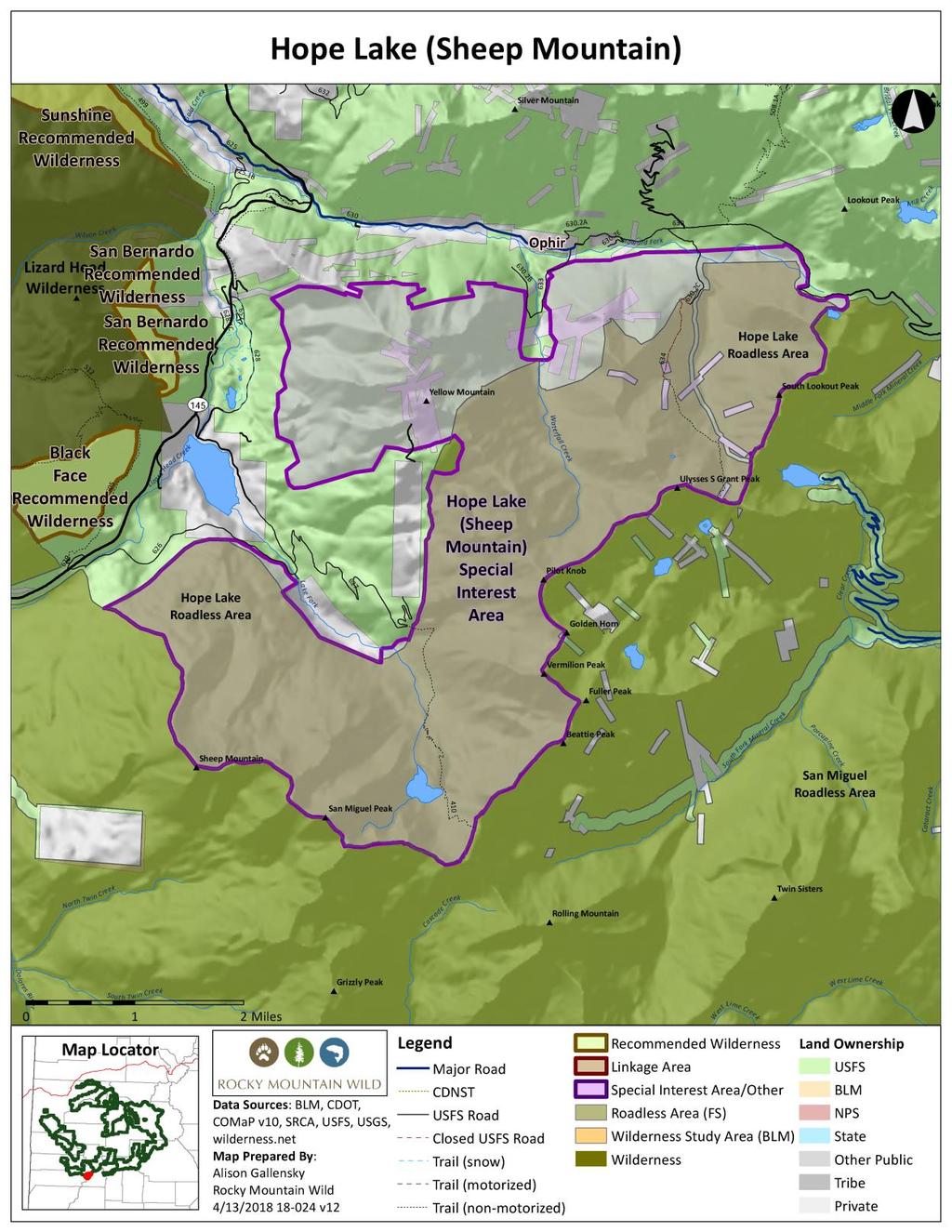
63
64 Kannah Creek Watershed Protection Area Proposed Designated Area Grand Mesa National Forest Grand Valley Ranger District 35,000 acres General Description Kannah Creek spans an ecological transition from the dry deserts of the Gunnison River valley to the lush forests atop Grand Mesa. The Kannah Creek CRA neatly contains the entirety of the Kannah Creek headwaters, from the aspen and spruce forests that characterize the upper reaches of Grand Mesa through a continuous transition downslope to pinyon-juniper woodlands and sagebrush steppe. The drainage provides a natural break through the basalt cliffs that line the mesa, and hence native peoples used Kannah Creek to access the top of Grand Mesa from the desert valleys below. Kannah Creek is in the City of Grand Junction s municipal watershed. Grand Junction first filed for water rights to Kannah Creek in 1907 for the purpose of securing a source of clean mountain water as a municipal supply rather than treat muddy Colorado River water. In 2006, Grand Junction enacted a watershed and water-supply protection ordinance. The primary purpose of the watershed protection ordinance is to protect the City s water supply and waterworks from injury and water supply from pollution or from activities that may create a hazard to health or water quality or a danger of pollution to the water supply of the City. The ordinance aims to protect the city s water sources, including springs, streams and reservoirs, from any land use activity that might cause pollution or water quality impacts. The ordinance was motivated in part by a fear of oil and gas leasing and exploration in the watershed. The city has calculated the value of its water rights conservatively at almost $200 million. Watershed Values The proposed Kannah Creek Watershed Protection Area incorporates the 34,600-acre Kannah Creek Colorado Roadless Area. The city s primary water intake and treatment facility is located on Kannah Creek immediately below the roadless area, at the national forest boundary. Several water-supply reservoirs occur in the upper portions of the Kannah Creek watershed. Kannah Creek is the largest creek coming off the west end of the Grand Mesa. The area is managed for non-motorized recreation, and a network of backcountry trails provide outstanding recreation opportunities for hikers, equestrians and mountain bikers. The area is readily defined by topographic features, including the Grand Mesa rim at the upper elevation, as well as by the national forest boundary on the south and west. The Kannah Creek watershed is an important calving area for elk. Wildlife and Botanical Values
65 The undisturbed nature of the Kannah Creek watershed protects an ecological transition through woodland and forest ecosystems that are significantly underrepresented in protected areas, including areas in the national wilderness preservation system. About one-third of the area consists of Colorado Plateau Pinyon-Juniper Woodland and Inter-Mountain Basins Montane Sagebrush Steppe. Another third includes Rocky Mountain Gambel Oak-Mixed Montane Shrubland and Rocky Mountain Aspen Forest and Woodland. These ecosystem types are represented at less than 20 percent at the forest level. Strict watershed protection management would provide a comparable level of habitat protection to wilderness designation in this instance. Blue Lake, Kannah Creek and Sheep Creek are also locally valued for their fish habitat and angler recreational resources. These waterways are important habitat for cutthroat, rainbow and wild brook trout. Uinta Basin hookless cactus (Sclerocactus wetlandicus), a threatened species, occurs in the southwestern portion of the area in dry shrub plant communities. Energy development and mining are significant threats to the species. The Land s End Potential Conservation Area identified by the Colorado Natural Heritage Program is partially contained within the proposed watershed protection area. The Land s End PCA is a B2- Very High Biodiversity Significance site that follows the escarpment on the south and west sides of Grand Mesa, which includes the northern part of the Kannah Creek, as well as Carson Lake. Biodiversity elements of specific interest include excellent occurrences of a globally imperiled species, Rothrock Townsend-daisy (Townsendia rothrockii), as well as good and fair occurrences of Grand Mesa penstemon (Penstemon mensarum), a globally imperiled species. Boundary, Size, and Access The Kannah Creek Watershed Protection Area is well defined by the Grand Mesa rim at the upper elevations, and the national forest boundary at lower elevations on the west and south. The watershed protection area is comprised of the entire 34,600-acre roadless area. There is a welldeveloped system of eight non-motorized trails that provide backcountry access to the area. Land s End Road (Forest Road 100) follows the northern boundary of the area, and the Kannah Creek road provides access to the lower trailhead for Kannah Creek. Proposed Management Specific management direction is proposed to ensure primacy of watershed protection as follows: The Kannah Creek Watershed Protection Area must be found unsuitable for oil and gas leasing and mineral material sales, and made discretionary no lease for watershed protection purposes. The area also needs to be withdrawn from mineral entry. Management direction must include prohibition of road construction and limitations on tree removal consistent with management prescribed by the Colorado Roadless Rule, 36 CFR Part (b), (b).
66 Mechanized vehicle use may only occur on designated routes that are located and managed to minimize impacts to watershed values. Best management practices are in place on all access routes and monitored regularly to ensure effectiveness. Develop an interpretive program for the area that educates visitors on the special character and watershed values of the area. Information Resources Item Roadlessness Data Source Colorado Roadless Rule at 36 CFR xx Forest Service inventory pursuant to FSH ,chapter 70, section 71 Water Supply City of Grand Junction Ordinance No. 3961, 2006 Supplemental Values Elk Production Area Elk Severe Winter Range Elk Winter Concentration Area Gunnison Sage-grouse Historic Habitat Lynx Potential Habitat Mule Deer Winter Concentration Area Land s End Potential Colorado Natural Heritage Program Potential Conservation Conservation Area with Very Areas 2017 High Biodiversity Significance
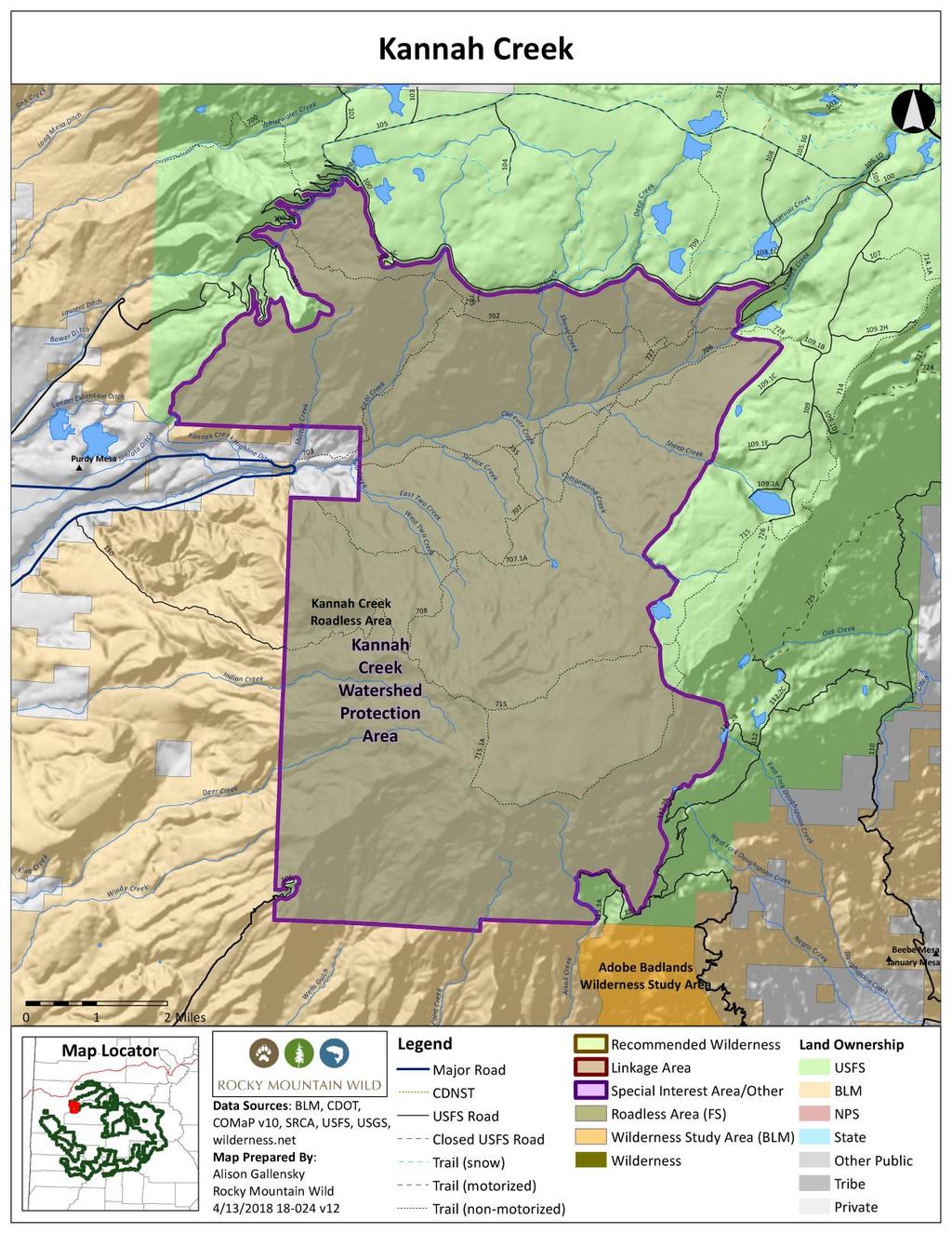
67

68 Kelso Mesa Recommended Wilderness Proposed Wilderness Designation Uncompahgre National Forest Grand Valley Ranger District 36,000 acres General Description Kelso Mesa is the largest roadless area on the Uncompahgre Plateau and encompasses the Middle Fork and North Fork of Escalante Creek, and intervening mesas. Large perennial streams flow off the plateau through an ecological transition that reaches to the lower elevations of the Uncompahgre Plateau. This spans a diverse set of landforms from shimmering aspen forests to red rock canyon walls. Kelso Mesa is adjacent to BLM s Dominguez-Escalante National Conservation Area and contains the roadless headwaters of Escalante Creek. Kelso Mesa bridges an elevational range from 6,600 to 9,200 feet and is dominated by ecosystem types barely represented within designated wilderness in Colorado. Chief among these are gambel oak-serviceberry woodlands, which blanket north-facing canyon slopes, and pinyonjuniper woodlands that grace south-facing slopes. A riparian corridor of narrowleaf cottonwood and occasional blue spruce transitions to stands of ponderosa pine and Douglas fir on shaded slopes. The mesas above the canyon rims of red, cliff-forming Wingate sandstone are covered with thick oak woodlands and robust stands of aspen. The combination of Kelso Mesa with the adjacent BLM National Conservation Area creates a quarter-million-acre region of wild, remote, undeveloped lands. They consequently offer outstanding recreational opportunities for exploring a region of dramatic scenery, ecological transitions and abundant wildlife. Naturalness Kelso Mesa is uncommon on the Uncompahgre Plateau for being such a large, roadless tract of gentle, undulating forests and sagebrush meadows. The area is bounded to the south by timber harvests on Love Mesa, but within Kelso Mesa there is no history of past timber management. Some prior twotrack vehicle routes have been converted to non-motorized trails.
69 Outstanding Opportunities for Solitude or Unconfined Primitive Recreation Kelso Mesa s large expanse and long canyons offer superlative opportunities for solitude. The Uncompahgre Plateau lacks the alpine peaks, mountain lakes and subalpine basins that draw multitudes of visitors elsewhere on the GMUG, and hence roadless areas such as Kelso Mesa receive less visitor pressure than most places on the forest. No other area of this size, remoteness and difficulty to access is found on the Uncompahgre Plateau. The sense of solitude is intimate while exploring dense aspen forests and dark stands of Douglas fir, but also expansive where sweeping panoramas open from rocky cliff tops and undulating meadows. An extensive network of non-mechanized trails extends throughout the area, which creates outstanding opportunities for hiking, equestrian use, hunting and fishing. Several parcels of private land are located at bottlenecks that diminish public access to several of the trails originating on the mesa top near the Divide Road. However, the Middle Point Escalante Creek trail is readily accessible from the Middle Fork canyon s mouth near the national forest boundary, and a nine mile trek provides access to the system of trails coursing across the mesa tops. The North Fork of Escalante Creek is blocked at the bottom end by private inholdings on the adjacent BLM land, but the Short Point trail is accessible from the top via the Brushy Ridge Road and traverses the length of the North Fork. The area is popular in fall with hunters who pursue elk and deer on foot and horseback. Size and Roadlessness Kelso Mesa contains 36,000 acres on the Uncompahgre National Forest, and is located in Mesa County. It is a large, compact shape with boundaries well-defined by primary roads including the Divide Road, Love Mesa Road and Brushy Ridge Road at the upper elevations, and by the national forest boundary at lower elevations. Kelso Mesa is contiguous with the Dominguez- Escalante National Conservation Area managed by BLM. Supplemental Values Kelso Mesa includes the headwaters of the Escalante Creek Potential Conservation Area identified by the Colorado Natural Heritage Program. Escalante Creek s North Fork and Kelso Creek are incorporated within the PCA to include the upper watershed necessary for continued natural surface flow and resultant fluvial processes such as flood scouring, lateral flow, and channel meandering, to maintain a dynamic distribution of riparian and wetland plant associations along the drainage. The lower half of the PCA is within BLM s adjacent Dominguez-Escalante National Conservation Area. The PCA is ranked as Very High Biodiversity Significance by CNHP. Kelso Mesa offers the greatest significant opportunity to protect large tracts of ecosystems significantly under-represented among existing wilderness areas at both the federal level and within the GMUG National Forest. Over 70 percent of Kelso Mesa consists of ecosystem types with less than five percent representation within existing designated wilderness at the federal level and at the forest level, primarily Rocky Mountain Gambel Oak-Mixed Montane Shrubland and Colorado Plateau Pinyon-Juniper Woodland. This is a direct consequence of Kelso Mesa s
70 geographic location spanning the elevational gradient from the national forest-blm boundary to the upper reaches of the Uncompahgre Plateau. Kelso Mesa enhances connectivity across a larger landscape by providing protection for nearly the entirety of the Escalante Creek watershed in conjunction with the adjacent downstream BLM Dominguez-Escalante National Conservation Area. With consideration of the immediately adjacent Dominguez Canyon roadless area to the north, the two national forest roadless areas largely complete protection for uplands bordering the National Conservation Area. Kelso Mesa offers the opportunity for cross-jurisdictional management cooperation between the Forest Service and BLM to protect one of the largest, wild landscapes in the upper Colorado Plateau. Manageability Kelso Mesa s boundary is compact and readily identifiable in the field along primary roads. Private land parcels block access into the lower ends of the North Fork of Escalante Creek and Kelso Creek thereby providing an added level of management protection against incompatible uses. Private land similarly blocks access from the upper reaches of Kelso Mesa and Short Point. This might restrict recreational access in places, but enhances manageability of wilderness resources. The area shares its lower elevation boundary entirely with BLM s Dominguez- Escalante National Conservation Area. Two private inholdings accessible only by trail are located at the lower reaches of Kelso Creek and the North Fork of Escalante Creek. There are no oil and gas leases within the boundaries and no apparent potential for oil and gas resources. Information Resources Item Data Source Roadlessness Naturalness; Outstanding Opportunities for Solitude or Unconfined Primitive Recreation Colorado Roadless Rule at 36 CFR xx Forest Service inventory pursuant to FSH ,chapter 70, section 71 Forest Service inventory pursuant to FSH ,chapter 70, section 72 USDA Forest Service, R2, Profiles of Colorado Roadless Areas 2008 GMUG Roadless Inventory & Evaluation for Potential Wilderness Areas, 2005 Supplemental Values Connectivity SREP Wildlands Network 2003, Aplet et al Indicators of Wildness 2000 Elk Production Area Elk Severe Winter Range Elk Winter Concentration Area
71 Gunnison Sage-grouse Historic Habitat Lynx Potential Habitat Escalante Canyon Potential Conservation Area with Very High Biodiversity Significance Colorado Natural Heritage Program Potential Conservation Areas 2017 Ecosystem Representation TWS Ecosystem Representation 2016
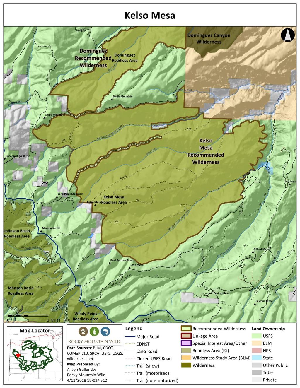
72
73

74 Cochetopa Creek Addition to La Garita Wilderness Proposed Wilderness Designation Gunnison National Forest Gunnison Ranger District 2,500 acres General Description The Cochetopa Creek proposed addition to the La Garita Wilderness is located in Saguache County, straddling the north side of the Continental Divide separating the Gunnison and Rio Grande National Forests. This addition would extend the La Garita Wilderness to the north from the juncture of Cochetopa and Nutras Creeks. It follows the Continental Divide to the east. The CDNST runs through the heart of this area. The braiding and meandering Cochetopa Creek runs the length of the area from north to south, emanating from high in the La Garita Mountains. Naturalness This area is very natural in appearance, albeit beetle kill has attacked spruce across this part of the forest. The valley floor along the creek is lush with willows and beaver ponds, providing outstanding riparian habitat. Forests are a mix of spruce, aspen and pine, giving way to open meadows along the Continental Divide. Outstanding Opportunities for Solitude or Unconfined Primitive Recreation While relatively small in size, Cochetopa Creek offers a diversity of outstanding opportunities for solitude and primitive recreation. The segment of the creek that runs through this addition offers fine fishing opportunities. Canyon walls radiating from the valley floor are moderately sloped, providing a sense of solitude. The CDNST runs alongside and then crosses the creek on its way to the Eddiesville and Stewart Creek trailheads. Elk are abundant in summer and fall, offering opportunities for backcountry hunters. Size and Roadlessness Cochetopa Creek is approximately 2,500 acres, and would be a logical addition to the 130,000- acre La Garita Wilderness. The area overlaps with the Cochetopa CRA and includes upper tier acreage.
75 Supplemental Values This addition to the La Garita Wilderness includes a pristine stretch of Cochetopa Creek. The area provides summer habitat for big game species (black bear, mule deer, elk, and moose). The drier forest types in this area are mapped as lynx habitat. The connectivity afforded to wildlife by this area s location between the peaks of the La Garitas and the lower elevations of Cochetopa Park make it appropriate for wilderness. Vegetative communities unique to the Gunnison area are found here, including bristlecone, limber and lodgepole pine. Manageability This area has no conflicting uses that would compromise its manageability as wilderness. The 2007 draft GMUG Forest Plan recommended 1,600 acres of this area for wilderness. It has no ditches or water developments, and the area has no known potential for oil and gas. Information Resources Item Data Source Roadlessness Naturalness; Outstanding Opportunities for Solitude or Unconfined Primitive Recreation Colorado Roadless Rule at 36 CFR xx Forest Service inventory pursuant to FSH ,chapter 70, section 71 Forest Service inventory pursuant to FSH ,chapter 70, section 72 USDA Forest Service, R2, Profiles of Colorado Roadless Areas 2008 GMUG Roadless Inventory & Evaluation for Potential Wilderness Areas, 2005 Supplemental Values Connectivity SREP Wildlands Network 2003, USDA Forest Service Southern Rockies Lynx Amendment, 2008 Aplet et al, Indicators of Wildness 2000, Belote et al, Identifying Corridors among Large Protected Areas in the United States, 2016 Elk Migration Pattern Lynx Potential Habitat
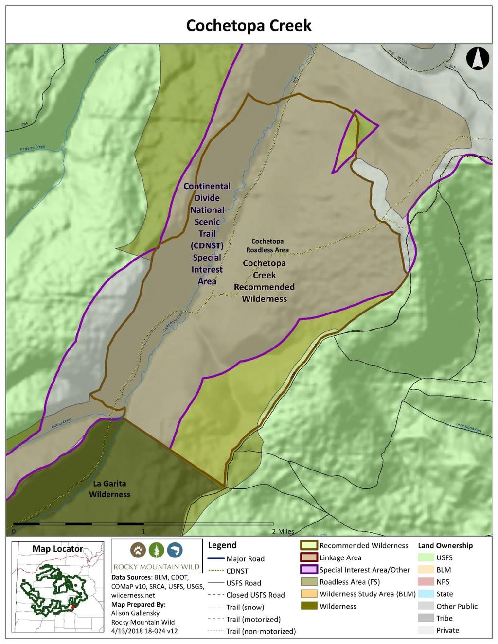
76

77 East Beaver Creek Wilderness Addition Proposed Wilderness Designation Uncompahgre National Forest Norwood Ranger District 3,600 acres General Description The East Beaver Creek Wilderness addition would extend the western boundary of the existing Lizard Head Wilderness, protecting the scenic viewshed of Flattop, Middle and Dunn Peaks from the west. The area encompasses the lower, forested slopes of the San Miguel Range, preserving a refuge for quiet recreation away from the heavily used Woods Lake and Wilson Mesa areas. This hidden gem includes groves of mixed spruce and aspen, as well as open meadows, riparian areas and beaver wetlands that provide excellent and varied wildlife habitat. As an extension of an area with recognized wilderness characteristics, the proposed addition is particularly desirable because it draws the edge of the Lizard Head Wilderness out to a natural boundary at Forest Service roads. Naturalness The East Beaver Creek area has experienced timber activity, but has for the most part revegetated naturally over the last 20 years since it was cut. The areas along access roads are heavily used by hunters in the fall, and for this reason a couple of informal dirt tracks were carved out with cherry stems. The current boundary has been drawn to specifically exclude human features such as the Gurley Ditch and a large clearing accessed by a rough track off of 619, where there are signs of a well-established seasonal hunting camp. Outstanding Opportunities for Solitude or Unconfined Primitive Recreation The East Beaver Creek area is adjacent to the spectacular western boundary of the Lizard Head Wilderness, just under the tall buttresses and curving slope of Middle and Dunn Peaks. From the higher points on the southern end, Dolores Peak s ochre rock comes into relief as well. The primitive Lone Cone Trail bisects the area, connecting Woods Lake to Lone Cone Station. It follows East Beaver Creek for several miles and is designated for horse or foot travel uses. Mechanized and motorized use is not an issue on this trail as it already crosses through the existing Lizard Head Wilderness Area.
78 Size and Roadlessness As currently proposed, this addition would be about 3,600 acres. The natural boundary at Saltado Creek in the Northeast provides a buffer from the roads and motorized travel in the popular Woods Lake State Public Use Area. The area is bounded on the north and west by two Forest Service roads, 619 and 611, respectively. The western side roughly contours alongside Beaver Creek, following its transition from mid-elevation aspen and spruce forest on the north to rich riparian wetlands on the south side, while the southwestern boundary is formed by a primitive road, 616. All established roads have been excluded from the proposed area. Supplemental Values In East Beaver Creek there are many opportunities for exceptional views of high neighboring peaks of up to 13,000 feet. Abundant wildflower areas can be enjoyed in meadows throughout the area. The combination of mid-elevation and higher alpine areas nearby ensures that there is ample wildlife habitat connectivity through migratory corridors. Manageability The region s steep and inaccessible terrain would discourage off-road travel and remove the need for prohibition signage. The existence of the Lone Cone Guard Station would also be an advantage to any localized management activity deemed necessary. In addition, specific areas used by a local outfitter for winter snowmobile guiding have been left out of the addition. Information Resources Item Roadlessness Naturalness; Outstanding Opportunities for Solitude or Unconfined Primitive Recreation Supplemental Values Lynx Potential Habitat Beaver Creek/Lone Cone Potential Conservation Area with Moderate Biodiversity Significance Data Source Colorado Roadless Rule at 36 CFR xx Forest Service inventory pursuant to FSH ,chapter 70, section 71 Forest Service inventory pursuant to FSH ,chapter 70, section 72 Colorado Natural Heritage Program Potential Conservation Areas 2017
79
 1,800 acres) General Description A set of wilderness additions is proposed to round out the boundary of the Lizard Head Wilderness.")

80 Lizard Head Wilderness Additions Proposed Wilderness Designation Uncompahgre National Forest Norwood Ranger District 3,060 acres total (Black Face 470 acres; San Bernardo 180 acres; Sunshine 610 acres; Wilson (Silver Pick Basin) 1,800 acres) General Description A set of wilderness additions is proposed to round out the boundary of the Lizard Head Wilderness. These reflect recent Forest Service land acquisitions, addition of lower forested slopes and protection of the scenic backdrop of the San Juan Skyway. Half of the additional acreage is located in Silver Pick Basin and adds the west face of 14,017- foot Wilson Peak into the wilderness, a result of the Forest Service acquiring a handful of patented mining claims in the basin in A 700-acre addition takes in the aspen covered slopes below Sunshine Mountain. The scenic slopes astride Lizard Head Pass are incorporated in a 1,200-acre addition to the wilderness below Black Face and San Bernardo Mountain. Together these additions comprise a section of the proposed San Juan Mountains Wilderness Act. Naturalness The Lizard Head Wilderness additions exclude evidence of past human activity. The historic mining activity in Silver Pick Basin is substantially unnoticeable when viewed in the context of the larger landscape. Outstanding Opportunities for Solitude or Unconfined Primitive Recreation The Silver Pick Basin addition includes the primary mountaineering routes to the summit of 14,017-foot Wilson Peak. Mountaineering is one of the predominant outstanding unconfined primitive recreation activities within the Lizard Head Wilderness. The Black Face addition includes the Wilson Meadows Trail, which is a popular hiking trail originating from Lizard Head Pass. The wilderness additions enhance the existing outstanding solitude within the Lizard Head Wilderness by further buffering the wilderness core from outside incompatible uses.
81 Size and Roadlessness The Lizard Head Wilderness addition is 3,060 acres contiguous with the existing 41,525-acre Lizard Head Wilderness. The proposed wilderness addition contains no roads. Supplemental Values The wilderness additions along Lizard Head Pass, particularly Black Face and San Bernardo Mountain, add protection to key elements of the Lizard Head Pass lynx linkage. This linkage area provides movement opportunities between blocks of habitat as well as maintaining permeability across the highway. The Silver Pick Basin Potential Conservation Area identified by the Colorado Natural Heritage Program is located in part within the proposed wilderness addition. This PCA includes several rare plants, including the globally imperiled San Juan whitlow-grass (Draba graminea), and two state rare species, Altai chickweed (Stellaria irrigua) and arctic draba (Draba fladnizensis). This PCA is rated by CNHP as possessing B2-Very High Biodiversity Significance. The Lizard Head wilderness additions make a modest contribution to increasing representation of otherwise poorly represented ecosystem types within the existing wilderness preservation system. The wilderness designation adds several hundred acres of Rocky Mountain Aspen Forest and Woodland, an ecosystem type with less than 20 percent representation in existing wilderness at the forest and federal level. Manageability Boundaries for the Lizard Head Wilderness addition were drawn to exclude motorized and mountain bike trails and historic roads. The only trails remaining within the area are foot and horse trails. There is no known oil and gas potential, and low potential for hardrock minerals within the area. The 2007 draft Forest Plan recommended Wilson as wilderness. Information Resources Item Roadlessness Naturalness; Outstanding Opportunities for Solitude or Unconfined Primitive Recreation Supplemental Values Data Source Colorado Roadless Rule at 36 CFR xx Forest Service inventory pursuant to FSH ,chapter 70, section 71 Forest Service inventory pursuant to FSH ,chapter 70, section 72 USDA Forest Service, R2, Profiles of Colorado Roadless Areas 2008 GMUG Roadless Inventory & Evaluation for Potential Wilderness Areas, 2005
82 Connectivity Elk Production Area Lynx Potential Habitat Beaver Creek/Lone Cone Potential Conservation Area with Moderate Biodiversity Significance South Fork San Miguel River Potential Conservation Area with High Biodiversity Significance Silver Pick Basin Potential Conservation Area with Very High Biodiversity Significance USDA Forest Service Southern Rockies Lynx Amendment, 2008 Colorado Natural Heritage Program Potential Conservation Areas 2017 Colorado Natural Heritage Program Potential Conservation Areas 2017 Colorado Natural Heritage Program Potential Conservation Areas 2017 Ecosystem Representation TWS Ecosystem Representation 2016
83
84 Lone Cone Special Interest Area Proposed Special Interest Designation Uncompahgre National Forest Norwood Ranger District 7,400 acres total General Description The Lone Cone SIA covers much of the northern and eastern slopes of iconic Lone Cone Peak, the most westerly freestanding mountain in the state of Colorado. At 12,613 feet, the unique and remote pyramid of Lone Cone is a striking regional landmark for many miles in all directions. It should be designated as an SIA to protect its outstanding recreational values related to mountaineering, backcountry hiking and primitive hunting, as well as its iconic profile as a scenic gem of southwestern Colorado. Uses that would compromise these values should be prohibited in the revised forest plan. The lower slopes of Lone Cone are covered in large groves of aspen, while higher slopes are dominated by spruce-fir forests. Mushroom foragers and hunters alike use the large tracts of wild land on Lone Cone to find food, while diverse wildlife species, including a satellite population of the threatened Gunnison Sage-grouse, occupy its diverse habitat. The peak is one of the westernmost areas of potential lynx habitat in Colorado. Lone Cone s alpine zone contains sections of windswept tundra, craggy rock fields, talus slopes, and an enormous rock glacier known as Devil s Chair, which pose a challenging route for mountain climbers. The summit and higher elevations offer stunning 360-degree views of mountain ranges in Utah and Colorado, as well as the Uncompahgre Plateau and Paradox Valley. Lone Cone is worthy of protection due to the potential for quiet recreation and for its outstanding wildlife and scenic values. Lone Cone rises out of surrounding ranchland on Wright s Mesa, towering alone at the end of Road 44Z. The boundary between the Uncompahgre and San Juan National Forests divides the summit of the peak and also forms the boundary between San Miguel and Dolores Counties. Boundaries have been drawn to exclude all motorized trails in the Lone Cone area. A Mountaineering Gem The Lone Cone area offers outstanding opportunities for
85 recreation. As a very isolated 12,613-foot peak, it does not see the same numbers of peakbaggers as other local 14ers and 13ers do, but anyone exploring Lone Cone will discover a true Colorado mountaineering gem. There is a trail that leads to treeline on the northeast ridge, but it is not identified as a trail on the Forest Service s website. Near treeline you can either ascend the northeast ridge which is a Class 3 and Class 4 scramble, or take the easier route across the Devil s Chair to climb the north ridge, where there are a few cairns and a visible user path. For the most part though, climbing to the summit involves rock hopping and scrambling. There are a few limited forest roads that provide access to Lone Cone (mostly along the east or northeast and southeast sides). These are used by hunters and snowmobilers in season, but the Forest Service website states that it receives light use and the approach to Lone Peak is not on a designated or marked route. Manageability While we are aware that the Forest Service is interested in doing some vegetation treatments in this area, the proposed SIA would not preclude that use. Rather, it would guide treatments to areas where they would be most effective and not compromise the SIA s outstanding values. Information Resources Supplemental Values Data Source Elk Production Area Lynx Potential Habitat Gunnison Sage Grouse Production Area Gunnison Sage Grouse Historical Range Beaver Creek/Lone Cone Potential Conservation Area with Moderate Biodiversity Significance Colorado Natural Heritage Program Potential Conservation Areas 2017 Ecosystem Representation TWS Ecosystem Representation 2016
86

87 Priest Mountain Special Interest Area Proposed Designated Area Grand Mesa National Forest Grand Valley Ranger District 12,000 acres General Description The Priest Mountain Area is comprised of extensive forests of aspen and subalpine spruce-fir, with a number of expansive meadows, including wetland areas. The wet meadows, springs, seeps, and wetlands contribute to a dependable water supply for farms, ranches and communities in the North Fork Valley. Priest Mountain rests between the 10,600-acre Currant Creek recommended wilderness to the south and 21,000-acre Elk Park recommended wilderness to the east. In addition, the Priest Mountain Elk Park complex, totaling 55,300 acres in the Grand Mesa and Gunnison National Forests, is separated by just two motorized routes and an over-the-snow route. Priest Mountain, as part of this greater complex, contains important wildlife habitat and is a critical watershed for municipal and agricultural users in the North Fork Valley. The area may have potential for oil and gas extraction, which poses a fundamental decision about the future use of this large, undeveloped landscape whether to commit it to energy development or to preserve its value for wildlife and downstream water users. Recreation Values Priest Mountain is located in one of the largest undeveloped roadless areas in Colorado. The low visitation during most of the year, ruggedness, and vegetative screening in this unit provide outstanding opportunites for solitude. There are also ample opportunities for unconfined and primitive recreation in the Priest Mountain unit. The dearth of interior trails, along with excellent big game habitat and migration corridors, provides outstanding opportunities for wildlife viewing, photography, hiking and hunting. The area is most intensely used in the fall as a primitive backcountry hunting experience. An over-the-snow route bisects the Priest Mountain proposed special management area in the center of the unit at a north-south direction. This routes links up with other over-the-snow routes in the Grand Mesa area, providing outstanding winter recreational opportunities.
88 Biological Values Priest Mountain contains large tracts of aspen dominated ecosystems and grasslands, both of which are poorly represented within the existing wilderness preservation system. About one-third of this area is comprised of ecosystem types with less than 20 percent representation at the forest level. These include Rocky Mountain Aspen Forest and Woodland, Rocky Mountain Subalpine- Montane Mesic Meadow, and Southern Rocky Mountain Montane-Subalpine Grassland. This area is an important elk production area, providing valuable summer range for deer and elk. The herds also migrate through the roadless area to lower elevation winter range. Boundary, Size and Access Priest Mountain is comprised of 12,000 acres, and is adjacent to wilderness recommendations to its south and east. The area is generally bounded by the motorized East Leon Trail and Green Mountain Trail on the north and south, respectively, and by other motorized trails and reservoirs on the east and west (Ella, Skimmed Milk and Triangle Stomp trails). Proposed Management There is one existing use within the Priest Mountain unit that conflicts with wilderness management, resulting in this proposed alternative management. This refers to the aforementioned over-the-snow motorized route that runs north-south through the central interior of the unit. Recommended management direction in the Forest Plan includes: Priest Mountain must be administratively unavailable for oil and gas leasing and mineral material sales, and a mineral withdrawal needs to be recommended for locatable minerals. Management direction must include a prohibition on commercial timber harvest, except where identified as a treatment area in SBEADMR management plan. New road and route construction should be prohibited as well. OSV use can occur on designated routes as can mechanized summer time use. Motorized and mechanized travel off designated routes should be disallowed. Information Resources Item Roadlessness Naturalness; Outstanding Opportunities for Solitude or Unconfined Primitive Recreation Data Source Colorado Roadless Rule at 36 CFR xx Forest Service inventory pursuant to FSH ,chapter 70, section 71 Forest Service inventory pursuant to FSH ,chapter 70, section 72
89 Supplemental Values Elk Production Area USDA Forest Service, R2, Profiles of Colorado Roadless Areas 2008 GMUG Roadless Inventory & Evaluation for Potential Wilderness Areas, 2005 Lynx Potential Habitat Moose Priority Habitat Ecosystem Representation TWS Ecosystem Representation 2016
90

91 Sawtooth Recommended Wilderness Proposed Wilderness Designation Gunnison National Forest Gunnison Ranger District 23,000 acres General Description Sawtooth is a wildlife stronghold on the south side of the Gunnison Basin. Sawtooth Mountain rises out of the sagebrush to soaring slopes covered by aspen, spruce and fir. The area harbors miles of streams crucial to the conservation of native Colorado River cutthroat trout, and offers security for calving elk herds. Sawtooth provides premier backcountry hunting and angling opportunities for hardy enthusiasts willing to explore its trail-less environs. The mountain and its roadless surroundings anchors prospective landscape linkages from one side to the other of the Gunnison Basin and makes the area an important cross-basin connector. Naturalness Sawtooth s boundary is denoted by forest roads, past timber management areas, and the national forest boundary. Several management roads that penetrated the area have been decommissioned and rehabilitated. The area therefore appears natural with no substantially noticeable developments. Outstanding Opportunities for Solitude or Unconfined Primitive Recreation Steep and rugged slopes combined with dense coniferous forests, along with its location in a quiet corner of the Gunnison Basin, provide outstanding opportunities for solitude. There are no trails within the area, which enhances the primary recreational pursuits of backcountry hunting and angling. The lack of trails places a premium on self-reliance and increases visitors sense of adventure to create outstanding opportunities for unconfined primitive recreation. Size and Roadlessness The roadless area encompassing Sawtooth Mountain is 23,000 acres and overlaps the Sawtooth CRA, the vast majority of which is upper tier acreage. Several motorized routes previously used
92 for management activities have been decommissioned and are returning to a natural condition, thus no roads presently exist within the area. Supplemental Values Sawtooth is a primary stronghold for Colorado River cutthroat trout in the southern Gunnison Basin. A dozen miles of two streams identified as priority conservation populations, Deer Beaver Creek and East Fork of South Beaver Creek, are located largely within the Sawtooth proposed wilderness. Both streams are within watersheds with the highest watershed integrity class i.e., the most pristine and least impacted by human activities. Sawtooth incorporates several ecosystem types that are underrepresented within the existing wilderness preservation system. About one-half of the roadless area consists of ecosystem types with less than 20 percent representation in existing wilderness at the forest and federal level. These underrepresented ecosystem types include Rocky Mountain Aspen Forest and Woodland, Rocky Mountain Lodgepole Pine Forest and Southern Rocky Mountain Montane-Subalpine Grassland. Manageability Sawtooth has no conflicting uses that would compromise its manageability as wilderness. There are no trails to support recreational activities that might compete with wilderness designation. The area has no potential for oil and gas or other mineral resources. The area s compact shape and well-delineated boundaries enhances its manageability. Sawtooth was recommended by the Forest Service for wilderness in the 2007 draft GMUG Forest Plan. Information Resources Item Data Source Roadlessness Naturalness; Outstanding Opportunities for Solitude or Unconfined Primitive Recreation Colorado Roadless Rule at 36 CFR xx Forest Service inventory pursuant to FSH ,chapter 70, section 71 Forest Service inventory pursuant to FSH ,chapter 70, section 72 USDA Forest Service, R2, Profiles of Colorado Roadless Areas 2008 GMUG Roadless Inventory & Evaluation for Potential Wilderness Areas, 2005 Supplemental Values Connectivity SREP Wildlands Network 2003, USDA Forest Service Southern Rockies Lynx Amendment, 2008 Aplet et al, Indicators of Wildness 2000, Belote et al, Identifying Corridors among
93 Large Protected Areas in the United States, 2016 Elk Production Area Elk Winter Concentration Area Gunnison Sage-grouse Historic Habitat Gunnison Sage-grouse Overall Range Lynx Potential Habitat Colorado Natural Heritage Program Potential Conservation Areas 2017 Gunnison Basin Potential Conservation Area Colorado Natural Heritage Program Potential with Outstanding Biodiversity Significance Conservation Areas 2017 Cutthroat Trout GMUG NF Cutthroat Trout species and conservation assessment, 2011 Ecosystem Representation TWS Ecosystem Representation 2016
94
 General Description The Last Dollar/Sheep Creek addition completes the Mount Sneffels Wilderness boundary above the town of Telluride.")
95 Last Dollar/Sheep Creek (Last Dollar/Liberty Bell) Addition to Mount Sneffels Wilderness Proposed Wilderness Designation Uncompahgre National Forest Norwood Ranger District 7,500 acres total (Last Dollar 2,600 acres; Liberty Bell 4,900 acres) General Description The Last Dollar/Sheep Creek addition completes the Mount Sneffels Wilderness boundary above the town of Telluride. The eastern Sheep Creek portion incorporates the entirety of Mill Creek Basin into the wilderness, whereas the current wilderness includes only the basin s north half. The Last Dollar addition extends the wilderness boundary west generally out to the Last Dollar Road. Both additions add lower aspen blanketed slopes to the wilderness. Last Dollar/Sheep Creek incorporates the remainder of several trails already partially within the wilderness, most significantly the Sneffels Highline Trail looping through Mill Creek Basin s alpine headwaters. The lower reaches of the Whipple Mountain and Alder Creek trails would also be added into the wilderness. Last Dollar/Sheep Creek additionally protects a conservation population of Colorado River cutthroat trout in Deep Creek s East Fork. This addition is known as the Last Dollar/Liberty Bell Addition in the proposed San Juan Mountains Wilderness Act. Naturalness Last Dollar/Sheep Creek consists of undeveloped lands adjacent to the existing wilderness. The addition lacks evidence of historic mines, roads, or timber management and is entirely natural in appearance. Outstanding Opportunities for Solitude or Unconfined Primitive Recreation Last Dollar/Sheep Creek extends the wilderness boundary to a lower elevation in many instances, but is still high above the San Miguel River valley and the town of Telluride. Thick aspen forests enhance the sense of solitude. Mill Creek Basin in particular is a high, isolated and remote alpine basin far from the sights and sounds of civilization with outstanding opportunities for solitude.
96 Multiple trails provide for outstanding opportunities for hiking and horse packing. The High Sneffels Trail offers a long looping hike from aspen forests outside Telluride to alpine tundra, passing through head-high fields of wildflowers in the summer. Outstanding backcountry skiing options are available in winter originating from the Last Dollar Road and ski hut along the western portion of the addition. Size and Roadlessness Last Dollar/Sheep Creek is 7,500 acres, and is contiguous with the existing 16,485-acre Mount Sneffels Wilderness. The proposed wilderness addition contains no roads. Supplemental Values The East Fork of Deep Creek within the proposed wilderness addition has been identified as a conservation population for Colorado River cutthroat trout. Last Dollar/Sheep Creek makes a modest contribution to increasing representation of otherwise poorly represented ecosystem types within the existing wilderness preservation system. The wilderness designation adds about 1,000 acres of Rocky Mountain Aspen Forest and Woodland, an ecosystem type with less than 20 percent representation in existing wilderness at the forest and federal level. Manageability The Last Dollar/Sheep Creek wilderness boundary is drawn to exclude conflicts. The southern boundary is defined by the Deep Creek trail, which would be left open to mountain bikes. The western boundary excludes the Last Dollar ski hut. There is low oil and gas potential, and low potential for hardrock minerals within the area. The 2007 draft Forest Plan recommended a portion of Last Dollar/Sheep Creek for wilderness. Information Resources Item Roadlessness Naturalness; Outstanding Opportunities for Solitude or Unconfined Primitive Recreation Supplemental Values Elk Production Area Data Source Colorado Roadless Rule at 36 CFR xx Forest Service inventory pursuant to FSH ,chapter 70, section 71 Forest Service inventory pursuant to FSH ,chapter 70, section 72 USDA Forest Service, R2, Profiles of Colorado Roadless Areas 2008 GMUG Roadless Inventory & Evaluation for Potential Wilderness Areas, 2005
97 Elk Severe Winter Range Elk Winter Concentration Area Lynx Potential Habitat Cutthroat Trout GMUG NF Cutthroat Trout Species and Conservation Assessment, 2011 Ecosystem Representation TWS Ecosystem Representation 2016
98
99
 General Description The Whitehouse Mountain addition to Mount Sneffels Wilderness completes the Mount Sneffels Wilderness and one of the most recognizable mountain")

100 Whitehouse Mountain Addition to Mount Sneffels Wilderness Proposed Wilderness Designation Uncompahgre National Forest Ouray Ranger District 12,760 acres total (Whitehouse Mountain East 12,000 acres; Whitehouse Mountain West 760 acres) General Description The Whitehouse Mountain addition to Mount Sneffels Wilderness completes the Mount Sneffels Wilderness and one of the most recognizable mountain scenes in Colorado. Countless scenic calendars include the blazing fall colors of the Sneffels Range as viewed from Dallas Divide. The addition would extend the wilderness boundary east from its current location atop the summit of Mount Sneffels to incorporate the remainder of the Sneffels Range. In addition to incorporating some of the most dramatic, classic and heavily photographed mountain scenery in the San Juans, Whitehouse Mountain includes wellknown mountaineering summits like Potosi Peak and Teakettle Mountain, as well as the popular Weehawken Trail near Ouray. The wilderness addition is bounded on the south by the Camp Bird Mine Road, which leads to Yankee Boy Basin and other four-wheel-drive routes heavily used during summer. Naturalness The precipitous slopes of Whitehouse Mountain are stereotypical rock and ice wilderness. The steep and rugged nature of the area, combined with an absence of precious metal deposits, precluded road construction and left the area in a natural, undisturbed condition. Outstanding Opportunities for Solitude or Unconfined Primitive Recreation The Whitehouse Mountain addition towers thousands of feet above Yankee Boy Basin and Camp Bird. The great elevational differential creates an outstanding sense of solitude, and most locations within the wilderness addition offer unrestricted vistas across much of southwest
101 Colorado. The peaks are much less visited than the popular namesake of the wilderness, Mount Sneffels, and lightly used trails like that in Blaine Basin offer solitary excursions through alpine flower fields. The rugged peaks of the Sneffels Range provide challenging mountaineering summits, particularly Potosi Peak and Teakettle Mountain. Other outstanding opportunities for primitive recreation include hiking the Weehawken Trail for views of waterfalls, alpine meadows, and wildflowers. Elk favor the high basins as summer concentration areas, and early season hunters seeking adventurous backcountry hunting can find abundant herds in these remote hideouts. Bighorn sheep favor the area in summer and move across it to access winter range near Ouray. Size and Roadlessness Whitehouse Mountain is 12,760 acres, and is contiguous with the existing 16,485-acre Mount Sneffels Wilderness. The proposed wilderness addition contains no roads. Supplemental Values Whitehouse Mountain encompasses a portion of two adjacent Potential Conservation Areas identified by the Colorado Natural Heritage Program. The Yankee Boy Basin/Blue Lakes Pass PCA was identified for its occurrence of Colorado Divide whitlow-grass (Draba streptobrachia). The East Fork Dallas Creek PCA was designated for its occurrence of a beaked sedge (Carex utriculata) wet meadow and a globally vulnerable lower montane willow carr (Salix drummondiana/calamagrostis Canadensis). Both sites are rated as B4-Moderate Biodiversity Significance. Manageability Whitehouse Mountain is well protected against incompatible uses by its precipitous topography. With a wilderness boundary drawn along the Dallas Trail, a winter ski hut and mechanized use are excluded from the proposed wilderness. Remaining trails within the area are non-mechanized. The area has low potential for oil and gas, and hardrock mineral exploration over the past century failed to discover any economically valuable deposits. The area includes a collection of patented mining claims in Blaine Basin, all of which are held by the same ownership. These are generally inaccessible and do not pose a serious impediment to wilderness management. The 2007 draft Forest Plan recommended Whitehouse Mountain for wilderness. Information Resources Item Roadlessness Naturalness; Outstanding Opportunities for Solitude or Unconfined Primitive Data Source Colorado Roadless Rule at 36 CFR xx Forest Service inventory pursuant to FSH ,chapter 70, section 71 Forest Service inventory pursuant to FSH ,chapter 70, section 72
102 Recreation Supplemental Values Bighorn Sheep Production Area Elk Production Area Lynx Potential Habitat Canyon Creek at Ouray Potential Conservation Area with High Biodiversity Significance Yankee Boy Basin/Blue Lakes Pass Potential Conservation Area with High Biodiversity Significance West Dallas Creek Potential Conservation Area with High Biodiversity Significance East Fork Dallas Creek Potential Conservation Area with Moderate Biodiversity Significance USDA Forest Service, R2, Profiles of Colorado Roadless Areas 2008 GMUG Roadless Inventory & Evaluation for Potential Wilderness Areas, 2005 Colorado Natural Heritage Program Potential Conservation Areas 2017 Colorado Natural Heritage Program Potential Conservation Areas 2017 Colorado Natural Heritage Program Potential Conservation Areas 2017 Colorado Natural Heritage Program Potential Conservation Areas 2017
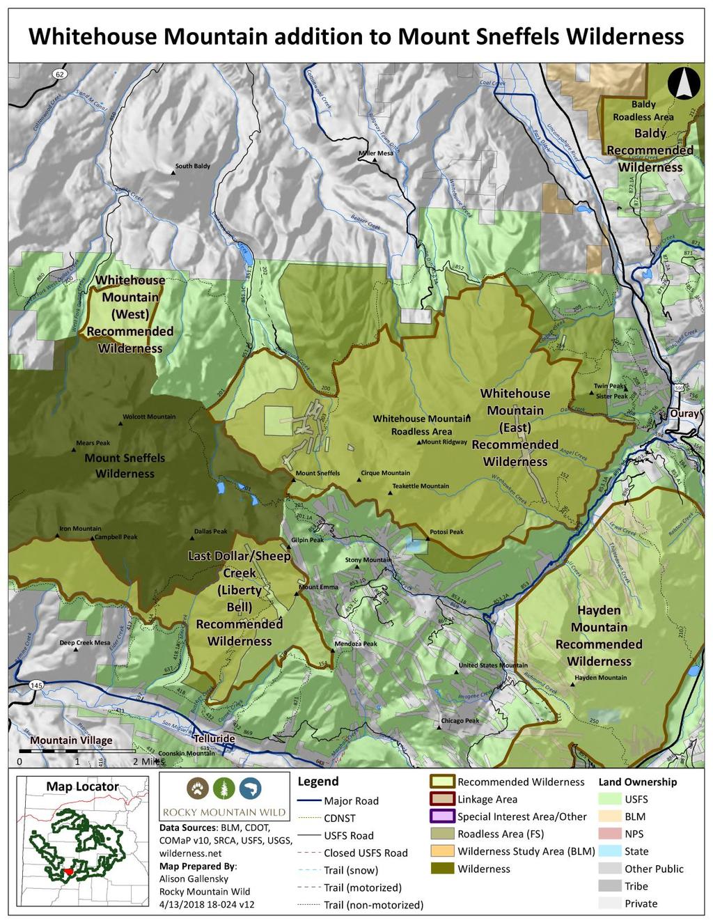
103

104 Sunnyside Recommended Wilderness Area Proposed Wilderness Area Grand Mesa National Forest Grand Valley Ranger District 11,000 acres General Description Sunnyside is adjacent to Plateau Creek Valley, in which the town of Collbran is located. The area is long and narrow, ranging from one to three miles wide. On its northern side, Sunnyside borders the 13,000-acre Housetop Mountain Roadless Area in the White River National Forest. The area s other boundaries are adjacent to both private land and BLM lands. The area is within the Northern Central Highlands and Rocky Mountain Eco-Section (M33IH) with elevations ranging from 6,000 to 9,200 feet. Naturalness Sunnyside possesses a remote and wild character, and it retains a high degree of naturalness. The area is undeveloped, and provides important habitat for various species of plants and animals. The lower elevations are dominated by pinyon-juniper with Douglas-fir increasing in the species mix as elevation increases. Gambel oak, serviceberry and snowberry shrub species are intermixed in the understories at the upper elevations and provide sustenance for a range of wildlife species and the predators that depend upon them. Outstanding Opportunities for Solitude or Unconfined Primitive Recreation Sunnyside is quite different than Grand Mesa in its topography, soils, landscape, wildlife and vegetation. The area is very steep, slopes are frequently barren, and there are dominant cliffs. The area is comprised of the same geologic formations and terrain as proposed South Shale Ridge wilderness on BLM lands west of the Colorado River. There are limited trails and access into the area. This isolation along with the ruggedness of the landscape and distance from the
105 sights and sounds of developments provides an opportunity for solitude and a sense of remoteness. Size and Roadlessness Battlement Mesa is a dramatic, 20-mile long east-west ridge that divides Plateau Creek from the Colorado River. The 10,700-acre Sunnyside recommended wilderness area, which overlaps completely with the lower tier Sunnyside CRA, is just one piece of a roadless complex that spans the length of the Battlement Mesa (including the Battlements, Housetop and Mamm Peak Roadless Areas), and it is proximate to a host of other roadless areas that continue east to the Crystal River and the Maroon Bells Snowmass Wilderness Area. This is an important piece of roadless land in the midst of a much greater network that provides important east-west and northsouth connectivity for migrating wildlife. Supplemental Values Dry Fork Kimball Creek is in the northeast corner has been identified for the presence of rare endemic plant species. The western half of this area is within The Nature Conservancy s Debeque South conservation site, which contains locations of Phacelia submutica, a candidate plant species. Mule deer and elk are known to concentrate in the winter at the lower elevations and summer at the higher elevations of the roadless area. Sunnyside has some of the highest densities of wintering deer in the state of Colorado. The Battlement Mesa Rocky Mountain bighorn sheep herd resides here. This herd is small in population, small in stature, and lives at relatively low elevations--making it unique from other herds. There are many problems facing this herd including lack of fire, access to other populations of sheep, and lack of water. Manageability The boundaries for this area are well defined by private land to the south, the White River National Forest to the north and Kimball Creek in the east and the 274 road in the west. The area is steep and inaccessible. It lends itself well to continued management for rare plants, wildlife, and roadless character. There has been oil and gas leasing in this area, though no drilling or road construction has occurred inside the roadless area. The area is long and narrow, and the terrain is steep. If future leasing is allowed in the area, minerals could be accessed directionally without involving new road construction. There is no suitable timber in the area.
106 Information Resources Item Data Source Roadlessness Naturalness; Outstanding Opportunities for Solitude or Unconfined Primitive Recreation Colorado Roadless Rule at 36 CFR xx Colorado Division of Wildlife NW Region, Comments on Grand Mesa National Forest Roadless Areas available at islandora/object/co:24707/datastream/obj/view Forest Service inventory pursuant to FSH ,chapter 70, section 71 Forest Service inventory pursuant to FSH ,chapter 70, section 72 USDA Forest Service, R2, Profiles of Colorado Roadless Areas 2008 GMUG Roadless Inventory & Evaluation for Potential Wilderness Areas, 2005 Supplemental Values Connectivity SREP Wildlands Network 2003, USDA Forest Service Southern Rockies Lynx Amendment, 2008 Aplet et al, Indicators of Wildness 2000, Belote et al, Identifying Corridors among Large Protected Areas in the United States, 2016 Bighorn Sheep Production Area Bighorn Sheep Winter Concentration Area Elk Production Area Elk Winter Concentration Area Gunnison Sage-grouse Historic Habitat Mule Deer Winter Concentration Area Rare Plants of the Wasatch Potential Conservation Area with Outstanding Biodiversity Significance Dry Fork Kimball Creek Potential Conservation Area with Very High Biodiversity Significance Colorado Natural Heritage Program Potential Conservation Areas 2017 Colorado Natural Heritage Program Potential Conservation Areas 2017
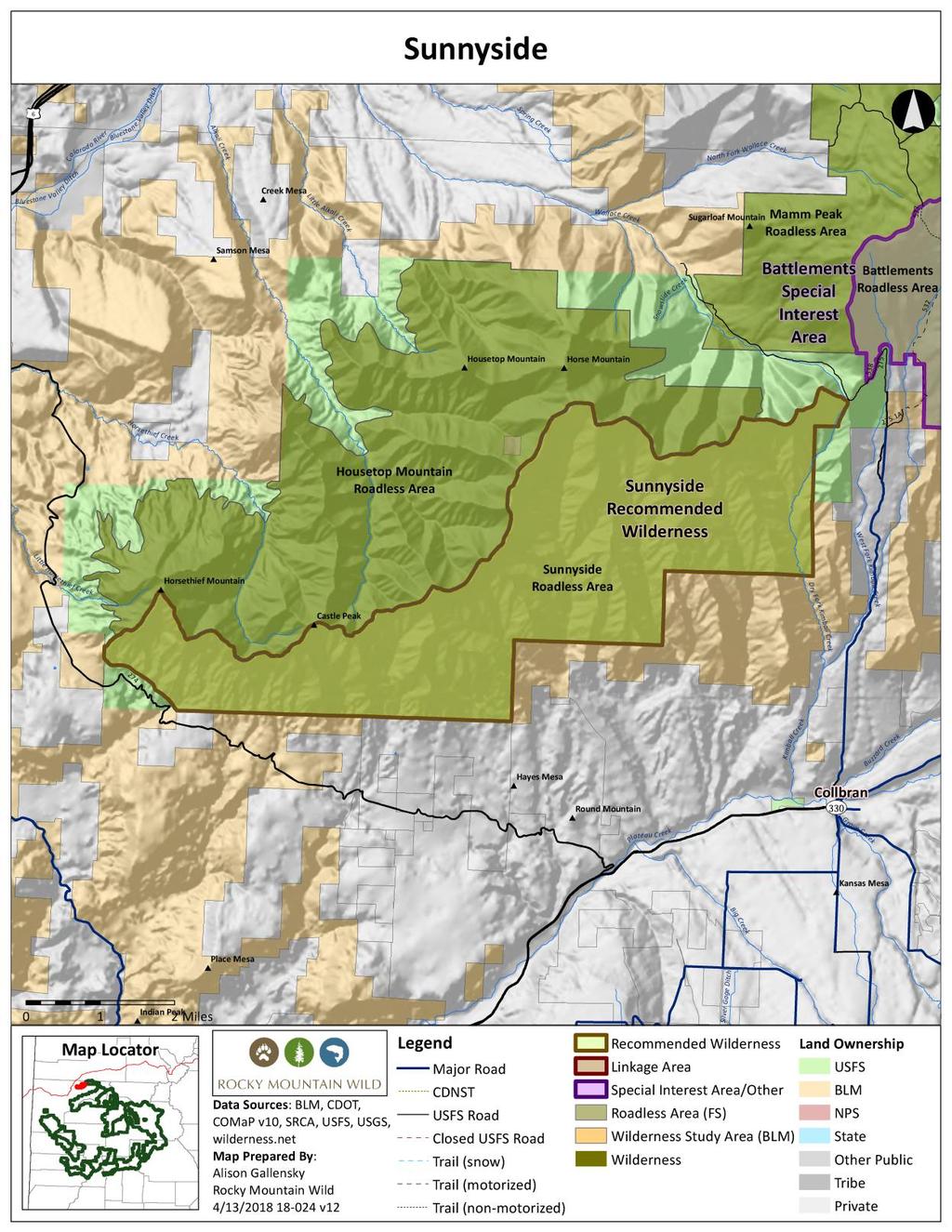
107

108 Turner Creek Special Interest Area Proposed Designated Area Gunnison/Grand Mesa National Forests Paonia/Grand Valley Ranger District 13,000 acres General Description The Turner Creek Area is located in both the Gunnison and Grand Mesa National Forests. The 12,900-acre area overlaps almost completely with the lower tier Turner Creek CRA. The dominant feature of this area is Spruce Mountain, which rises to 10,833 feet in the northeast corner of the unit. On the southern face of Spruce Mountain, a large slump exposes well-defined reddish colored sandstone and shale layers of the Tertiary Wasatch Formation. The headwall of the slump and terrain extending to the south from the headwall are complexly eroded and form an amphitheater-like setting with attractive rock spires, somewhat reminiscent of a small scale Bryce Canyon. The forest in this area is predominantly aspen and spruce, which appear natural and very healthy. The spruce forest covering the gentle upper northern slope of the aptly named Spruce Mountain appear particularly rich in dark green color. The Turner Creek area provides important wildlife habitat, migration corridors, and production areas. The large interior park areas, with meadows, creeks, ponds, and wetlands areas, provide ideal wildlife habitat. A few perennial creeks begin or flow through this unit, including Turner Creek, Crane Creek and Spring Creek. A small reservoir and a few cabins were observed just outside the southeast corner of the area. Several gas development pads were observed near, but outside the south boundary as well. Similarly, roads and trails were observed near but outside both the eastern and western boundaries. The only obvious sign of human activity within the area was a narrow swath of cleared trees running north-south along the lower eastern slopes of Spruce Mountain. No vehicle tracks or electricity lines were apparent in this swath, but from aerial observation, it appeared to follow the route of the Bull Mountain pipeline with an easement of some type.
109 Overall, Turner Creek is a very remote and natural area with exceptional geologic and scenic value. Recreation Values Turner Creek is located in a large, mostly undeveloped roadless area. Much of the area has high habitat and range values for big game animals, particularly elk, lending itself to excellent opportunities and historically significant use for hunting. The most extensive use in this unit is in the fall due to high-valued hunting. There are also outstanding opportunities for wildlife viewing, photography, hiking, horseback riding, and scenic viewing. The eastern-to-central portion of this unit has designated motorized ATV trails for vehicles 50 inches and under (USFS 522, USFS 522.1A) that traverse into the interior of the unit. These routes link up with other designated motorized routes in the Grand Mesa and Gunnison (and White River) National Forests, providing outstanding motorized recreational opportunities and providing access for hunters. Biological Values Over half of the Turner Creek area is dominated by aspen ecosystems, which are poorly represented within the existing wilderness preservation system. Spruce-fir forests make up about one-third of the unit. The remainder of the unit contains several ecosystem types with less than 20 percent representation at the forest level. These include Rocky Mountain Subalpine-Montane Mesic Meadow, Rocky Mountain Alpine-Montane Wet Meadow, Rocky Mountain Subalpine- Montane Riparian Shrubland, and Southern Rocky Mountain Montane-Subalpine Grassland. This Turner Creek area is an important elk production area, providing valuable summer range for deer and elk on the high elevation northwest slopes of Spruce Mountain. The herds also migrate through the roadless area to lower elevation winter range in the southeast section of this unit. Moose inhabit the area year round and the area has been mapped for lynx habitat. Boundary, Size and Access Turner Creek is comprised of 13,000 acres and is adjacent to the western boundary of the Clear Fork Special Management Area and 24,200-acre Roadless Area. It is separated from the latter by a gas pipeline. The area is bounded by motorized route USFS 520 to the west, USFS 268 and an over-the-snow motorized route to the north, a gas pipeline to the east, and a leasing boundary south. The gas development pads and infrastructure were excluded from the unit boundaries to the south. Proposed Management There is one existing use in the Turner Creek unit that conflicts with wilderness management, resulting in this proposed alternative management. This refers to the aforementioned designated motorized routes in the eastern-to-central portion of the unit.
110 Recommended management direction in the Forest Plan includes: Turner Creek must be administratively unavailable for oil and gas leasing and mineral material sales. Management direction should include a prohibition on commercial timber harvest unless otherwise included in SBEADMR management. New road and route construction should also be prohibited. Turner Creek must be closed to winter motorized travel, and summer travel must be limited to non-mechanized activities. The area remains available for designated motorized routes. Information Resources Item Data Source Roadlessness Naturalness; Outstanding Opportunities for Solitude or Unconfined Primitive Recreation Supplemental Values Boreal Toad Overall Range Colorado Roadless Rule at 36 CFR xx Forest Service inventory pursuant to FSH ,chapter 70, section 71 Forest Service inventory pursuant to FSH ,chapter 70, section 72 USDA Forest Service, R2, Profiles of Colorado Roadless Areas 2008 GMUG Roadless Inventory & Evaluation for Potential Wilderness Areas, 2005 Elk Production Area Lynx Potential Habitat Moose Concentration Area Moose Priority Habitat Ecosystem Representation TWS Ecosystem Representation 2016
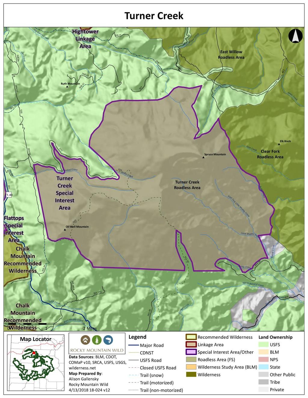
111

112 Unaweep Recommended Wilderness Proposed Wilderness Designation Uncompahgre National Forest Grand Valley Ranger District 11,000 acres General Description Unaweep includes the deepest and most dramatic portions of Unaweep Canyon, reaching depths as much as 3,300 feet. A number of steep canyons, such as 1,000-foot deep Ute Creek, drain the Uncompahgre Plateau as they cut through the area. The citizen proposed wilderness encompasses both the Unaweep national forest roadless area and adjacent lands with wilderness character identified by the Grand Junction BLM. The Uncompahgre National Forest component takes in the gently sloping mesa tops at the north end of the Uncompahgre Plateau, while the BLM portion includes the steeper canyons. Unaweep contains representative examples of western Colorado's scenic canyons, gambel oak and pinyon-juniper woodlands, and aspen forests that provide scenic backdrops to the Unaweep Tabeguache Scenic and Historic Byway. The Unaweep Trail along the top of the plateau affords spectacular views of the La Sal Mountains, Lone Cone Peak, the Abajo Mountains, and Unaweep Canyon. The Unaweep Trail traverses several of the aspen glades that characterize the uppermost portions. Hiking, hunting, backpacking, horse packing, and photography are popular recreational uses of the area. Mule deer and elk are common big game animals, and black bear and mountain lion also frequent the area. Naturalness Unaweep spans the northern end of the Uncompahgre Plateau where it drops into Unaweep Canyon. The area consists largely of steep slopes and precipitous canyon walls that preclude roads and other impairing activities. The BLM s similarly named Unaweep lands with wilderness character unit bounds the area on the north and west. Open roads and motorized trails the Pine Mountain Road and the Snowshoe Trail define the southern boundary. The rim of the plateau, and then the Rim Trail (601), denote the eastern boundary, and excludes areas used by snowmobiles in winter and any need to cherry stem the Rim Road. The Grand Junction BLM reached a similar conclusion about the area s naturalness, finding a unit of 7,154 acres to have wilderness character out of a larger 9,494-acre inventory unit.
113 Outstanding Opportunities for Solitude or Unconfined Primitive Recreation Unaweep s sweeping vistas across the Dolores River canyon toward the La Sal Mountains in nearby Utah enhance the area s outstanding sense of solitude. Steep slopes, rocky crags, and dense oak woodlands dissuade hikers from venturing far off the Unaweep Trail, the only maintained trail within the area. An unmaintained route parallels the upper portion of Ute Creek. Intrepid hikers are guaranteed outstanding opportunities for solitude. The Unaweep Trail provides a thorough circuit along the upper reaches of the area, and traverses most of the area s boundary to provide outstanding opportunities for unconfined primitive recreation. This non-mechanized trail is located below the plateau s rim and meanders largely through oak woodlands, providing ample unobstructed views of Unaweep Canyon, the Dolores River canyon, and the La Sal Mountains. The area receives some use during fall hunting seasons by those seeking backcountry hunting opportunities remote from the more vehicle-accessible areas typical of much of the Uncompahgre Plateau. Size and Roadlessness Unaweep is 11,000 acres as a stand-alone unit on the Uncompahgre National Forest. When considered in conjunction with the adjacent 9,494-acre wilderness inventory unit on BLM, it has a compact area configuration of about 20,500 acres. The area is entirely roadless, with some prior historic routes at the headwaters of Ute Creek closed and rehabilitated. Supplemental Values Because of its location along the flanks of the Uncompahgre Plateau, Unaweep is dominated by gambel oak woodlands, one of the least represented ecosystem types within designated wilderness both at the federal level and the individual forest level. Fully two-thirds of Unaweep is covered by these poorly represented ecosystem types, primarily Rocky Mountain Gambel Oak-Mixed Montane Shrubland, less than five percent of which is included with designated wilderness. Unaweep includes a large portion of Unaweep Seep Potential Conservation Area identified by the Colorado Natural Heritage Program. This portion of the PCA was incorporated both to include known colonies of the "Unaweep Canyon population" of the Great Basin silverspot butterfly as well as the potential spring recharge zones necessary to preserve hydrological integrity of the seep/spring wetland complexes. This PCA is rated by CNHP as possessing B2- Very High Biodiversity Significance. The northern end of the Uncompahgre Plateau includes a network of adjacent and nearby undeveloped roadless areas on both the national forest and BLM. Unaweep is at the center of this collection of roadless areas that includes Calamity Basin Colorado roadless area immediately to the south, the Unaweep lands with wilderness character inventory unit adjacent on the west, and other nearby BLM roadless areas including the Palisade Wilderness Study Area, and the Maverick and Lumsden Canyon wilderness inventory units. Unaweep falls in the center of the primary east-west connectivity corridor across the Uncompahgre Plateau, which is comprised of these undeveloped areas.
114 Manageability The plateau rim creates an obvious geographic wilderness boundary that dissuades unauthorized motorized intrusions. The majority of the area s boundary is along lands managed by BLM for their wilderness character. There are no oil and gas leases within the area and low potential for oil and gas resources. The 2007 draft Forest Plan recommended Unaweep for wilderness. Information Resources Item Data Source Roadlessness Naturalness; Outstanding Opportunities for Solitude or Unconfined Primitive Recreation Colorado Roadless Rule at 36 CFR xx Forest Service inventory pursuant to FSH ,chapter 70, section 71 Forest Service inventory pursuant to FSH ,chapter 70, section 72 USDA Forest Service, R2, Profiles of Colorado Roadless Areas 2008 GMUG Roadless Inventory & Evaluation for Potential Wilderness Areas, 2005 Grand Junction Field Office Draft RMP and EIS 2012 Supplemental Values Connectivity SREP Wildlands Network 2003, Aplet et al, Indicators of Wildness 2000 Belote et al, Identifying Corridors among Large Protected Areas in the United States, 2016 Elk Production Area Elk Severe Winter Range Elk Winter Concentration Area Gunnison Sage-grouse Historic Habitat Lynx Potential Habitat Mule Deer Winter Concentration Area Unaweep Seep Potential Conservation Area Colorado Natural Heritage Program Potential with Very High Biodiversity Significance Conservation Areas 2017 Ecosystem Representation TWS Ecosystem Representation 2016
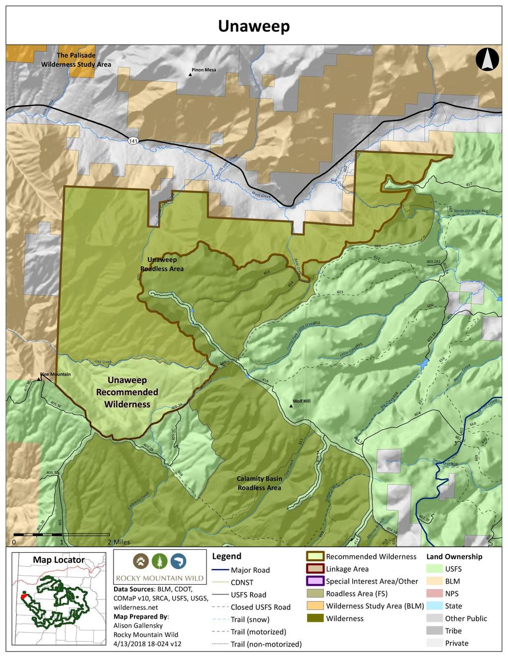
115
116

117 Baldy Addition to Uncompahgre Wilderness Proposed Wilderness Designation Uncompahgre National Forest Ouray Ranger District 2,400 acres General Description The Baldy addition to the Uncompahgre Wilderness adds critical wildlife habitat to the existing wilderness and extends the wilderness to lower elevation habitats that are generally not included within designated wilderness on the GMUG. Gambel oak and oak/aspen dominate the lower elevations transitioning to aspen and mixed aspen-conifer (including pine) with spruce-fir at higher elevations and north-facing slopes. Several meadows also exist in the area. Naturalness The Baldy roadless area appears generally natural with few obvious imprints of human activity. One metal water basin with a pipe exists at approximately 9,600 feet at the location of a natural spring, but does not detract from the character and is barely visible from the trail. Outstanding Opportunities for Solitude or Unconfined Primitive Recreation Although the hike to Baldy Peak is relatively easy and the summit tops out at only 10,603 feet, there are ample opportunities for solitude and a sense of seclusion and tranquility. Given that this roadless area abuts designated wilderness, one experiences the vast wild landscape and expansive views that Baldy Trail affords. There is no motorized or mechanized use on the trail, and there is no evidence of backcountry campsites or fire rings along this section of the Baldy Trail. Most users hike to the summit as a day trip so established campsites are absent. The area is primarily popular for hiking and hunting during fall big game seasons. Panoramic scenic vistas are a highlight of this proposed addition and the Baldy Trail. Kelvin Kent, in his book Ouray Hiking Guide, writes, it offers some of the best views and scenery of any trail Views south reach beyond Cutler Creek, the Amphitheater, Abrams and Brown Mountain to the Red Mountains and the high San Juans. The Sneffels and Cimarron Ranges are
118 sighted as one climbs with spectacular views of some of the region s highest peaks. On a clear day, a hiker is treated to views as distant as the La Sal Mountains in eastern Utah. Size and Roadlessness Baldy is about 2,400 acres in size, but is contiguous with the adjacent 102,214-acre Uncompahgre Wilderness. There are no roads within the unit. Supplemental Values The Baldy wilderness addition would contribute to increasing representation of otherwise poorly represented ecosystem types within the existing wilderness preservation system. The wilderness designation adds about 400 acres of Rocky Mountain Gambel Oak-Mixed Montane Shrubland, an ecosystem type with less than five percent representation in existing wilderness at the forest and federal level, and also about 750 acres of Rocky Mountain Aspen Forest and Woodland, which is represented at less than 20 percent at the forest level. Baldy provides significant wildlife habitat, particularly as bighorn sheep summer and winter range, a winter concentration area for both elk and mule deer, severe winter range for elk, and an elk production area. Manageability The boundaries of the proposed Baldy addition allow ample buffer from motorized roads and signage is already in place, limiting the trail to hikers and horses. It is bounded by BLM lands generally on the west, and private lands to the north, and is adjacent to the existing wilderness to the east. There is low oil and gas potential. Information Resources Item Roadlessness Naturalness; Outstanding Opportunities for Solitude or Unconfined Primitive Recreation Supplemental Values Bighorn Sheep Winter Concentration Area Data Source Colorado Roadless Rule at 36 CFR xx Forest Service inventory pursuant to FSH ,chapter 70, section 71 Forest Service inventory pursuant to FSH ,chapter 70, section 72 USDA Forest Service, R2, Profiles of Colorado Roadless Areas 2008 GMUG Roadless Inventory & Evaluation for Potential Wilderness Areas, 2005
119 Elk Production Area Elk Severe Winter Range Elk Winter Concentration Area Gunnison Sage-grouse Historic Habitat Lynx Potential Habitat Mule Deer Winter Concentration Area Ecosystem Representation TWS Ecosystem Representation 2016

120


121 Bear Creek Addition to Uncompahgre Wilderness Proposed Wilderness Designation Uncompahgre National Forest Ouray Ranger District 6,000 acres General Description The Bear Creek addition to the Uncompahgre Wilderness brings the wilderness boundary closer to Highway 550 the Million Dollar Highway -- incorporating the entirety of the Bear Creek watershed, from the highway to the alpine tundra atop Engineer Pass. It includes seven miles of the Bear Creek National Recreation Trail, so designated owing to its extraordinary scenery and the uncommon nature of its construction literally dynamited out of the cliff along the lower reaches of Bear Creek. The wilderness addition extends north to include the entirety of the Bridge of Heaven and the Horsethief Trail along Cascade Mountain, a hiking route with incomparable views and dramatic drop-offs. Land acquisitions have consolidated federal ownership along Bear Creek, with the majority of remaining patented claims on the most precipitous cliffs at the lower end of the creek, near the highway. The rugged nature of Bear Creek precludes constructed road access to these inholdings, making conflicts with future wilderness management unlikely. Bear Creek is a superlative wilderness candidate and adds seven miles of roadless valley to the wilderness. The trail is for hikers only owing to the long, horizontal shelves blasted out of the cliff faces and the sheer drop-offs to the creek below. Two historic mining camps add historical flavor and interest to the adventure. A myriad of waterfalls from trickles to thundering cascades enhances both the scenery and the auditory appeal of the wilderness. Naturalness The Bear Creek trail was originally developed by miners starting in the 1870s, and remnants of historic activities occur at several locations. These dilapidated cabins and rusting mining equipment add historic value and do not detract from the larger undeveloped character of the valley. The historic mining relics are similar in scale to those frequently encountered in other wilderness locations,
122 including Chicago Basin in the Weminuche and Silver Jack Mine in the Uncompahgre. The Bridge of Heaven and Horsethief Trail addition is in superlative natural condition. It includes the steep slopes above various historic mines, such as the Portland Mine and the Chief Ouray Mine, all of which are excluded from the wilderness addition. Outstanding Opportunities for Solitude or Unconfined Primitive Recreation The Bear Creek valley and trail offer outstanding opportunities for solitude. The trail rapidly gains elevation from Highway 550, creating a substantial elevation separation from the highway. Once the trail wraps around into the entrance of the valley, the steep walls close in and create a sensation of complete isolation. The Horsethief Trail offers outstanding opportunities for solitude, seclusion and tranquility. Access is via 4WD, high-clearance roads and the trails are steep, so the trail and area are not heavily used. The Bear Creek National Recreation Trail was designated in recognition of its unique and spectacular nature. The trail was established initially by miners in the late 1800s, and required blasting a ledge into cliff faces to skirt the most precipitous canyon segments. This creates a remarkable and scenic experience unlike any other in southwest Colorado. The trail and surroundings offer outstanding opportunities for unconfined primitive recreation. The Horsethief Trail leads to Bridge of Heaven, one of the classic hikes in the Ouray area that leads to phenomenal views high above treeline. Size and Roadlessness Bear Creek is about 6,000 acres in size, but is contiguous with the adjacent 102,214-acre Uncompahgre Wilderness. There are no roads within the unit. Supplemental Values Relics of hardrock mining provide historic interest. The Grizzly Bear Mine and Yellow Jacket Mine were established in the late 1800s, with both ceasing operation by The ruins of several cabins, a tunnel, and mining equipment mark the location of the Grizzly Bear Mine. The Yellow Jacket mining camp is better preserved, with an intact bunk house and assorted mining equipment. Both sites make for intriguing trip destinations. Bear Creek provides significant wildlife habitat, particularly as bighorn sheep summer and winter range, and as a bighorn sheep production area. The area is also a winter concentration area for elk. Manageability Bear Creek s rugged lower end precludes the possibility of motorized access from Highway 550 to the patented mining claims that dot the valley s cliffs. There is no vehicle access from the top, from Engineer Pass. For safety reasons, the trail is limited to hikers only. There is no oil and gas potential, and apparently limited potential for hardrock minerals since the last production ceased in the early 1900s.
123 The Horsethief Trail portion is steep, which precludes unauthorized motorized incursions. The boundary excludes all of the developed and patented mining claims in the lower portions below the wilderness boundary in Cascade Creek, Bridalveil Creek, and Dexter Creek. Information Resources Item Data Source Roadlessness Naturalness; Outstanding Opportunities for Solitude or Unconfined Primitive Recreation Colorado Roadless Rule at 36 CFR xx Forest Service inventory pursuant to FSH ,chapter 70, section 71 Forest Service inventory pursuant to FSH ,chapter 70, section 72 USDA Forest Service, R2, Profiles of Colorado Roadless Areas 2008 GMUG Roadless Inventory & Evaluation for Potential Wilderness Areas, 2005 Supplemental Values Connectivity SREP Wildlands Network 2003, USDA Forest Service Southern Rockies Lynx Amendment, 2008 Aplet et al, Indicators of Wildness 2000, Belote et al, Identifying Corridors among Large Protected Areas in the United States, 2016 Bighorn Sheep Production Area Elk Winter Concentration Area Lynx Potential Habitat Dexter Creek Potential Conservation Area with Moderate Biodiversity Significance Historic Colorado Natural Heritage Program Potential Conservation Areas 2017 David Day, Colorado's Incredible Backcountry Trails, 2009
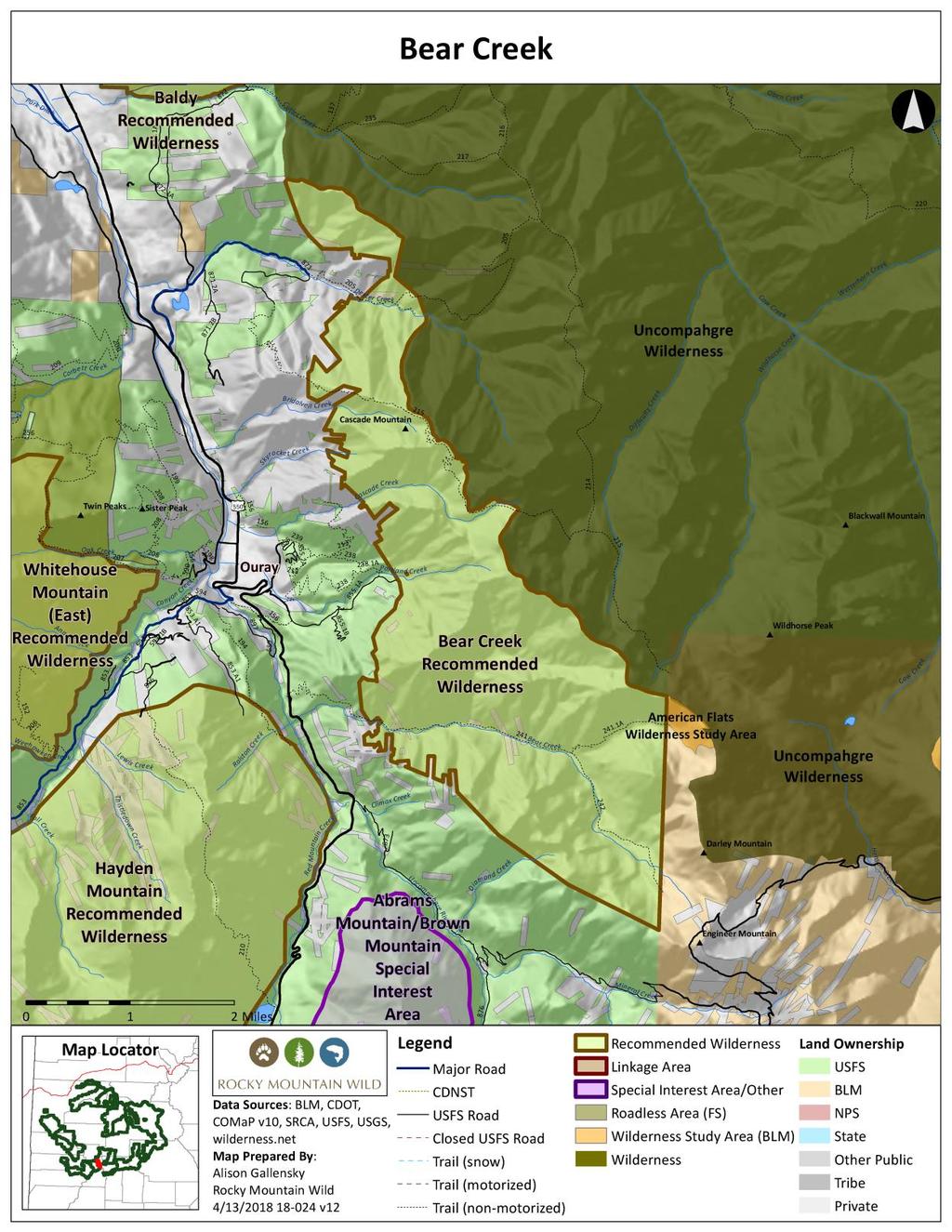
124
 General Description The Matterhorn addition to the Uncompahgre Wilderness consists of 3,600 acres at the headwaters of the North Fork of Henson Creek, and includes lower")

125 Crystal Peak and Matterhorn Additions to Uncompahgre Wilderness Proposed Wilderness Designation Gunnison National Forest Gunnison Ranger District 15,600 acres total (Crystal Peak 12,000 acres; Matterhorn 3,600 acres) General Description The Matterhorn addition to the Uncompahgre Wilderness consists of 3,600 acres at the headwaters of the North Fork of Henson Creek, and includes lower Matterhorn Creek and trail which provides the primary access to 14,015-foot Wetterhorn Peak. The wilderness addition would move the wilderness boundary down to an easily recognizable location along Henson Creek s North Fork. Matterhorn is an upper tier roadless area previously recommended for wilderness in Crystal Peak comprises 12,000 acres east of Nellie Creek, the primary access route for climbers seeking to summit Uncompahgre Peak. The main visitor attractions are several lakes in forested settings Crystal Lake and Larson Lakes and fall hunting seasons. The northern portion of the area consists of open, rolling tundra that melds seamlessly into the adjacent Uncompahgre Wilderness. Naturalness Historic mining exploration occurred in both roadless units, but the routes have long been closed to motorized use and have recovered such that impacts to naturalness are substantially unnoticeable. Outstanding Opportunities for Solitude or Unconfined Primitive Recreation Matterhorn lies in the remote headwaters of Henson Creek at the end of several miles of 4WD road, adjacent to a rugged wilderness. Crystal Peak is a large block of lightly visited forests and tundra. Both contain numerous opportunities for outstanding solitude.
126 Matterhorn includes three trails that access that adjacent wilderness, including the primary hiking route for climbers seeking to attempt one of the area s fourteeners, Wetterhorn Peak. Crystal Peak similarly is located adjacent to the Nellie Creek trailhead, which is the main access point for climbers heading to Uncompahgre Peak, another fourteener. Crystal Peak has a system of looping hiking and horse trails that connect to wilderness trails, but also offer access to several lakes in high forested basins. Both areas provide outstanding opportunities for unconfined primitive recreation typical of wilderness settings. Size and Roadlessness Matterhorn is about 3,600 acres in size and Crystal Peak is 12,000 acres. Both are contiguous with the adjacent 102,214-acre Uncompahgre Wilderness. There are no roads within the units. Supplemental Values Matterhorn and Crystal Peak lie within the heart of the large elk migration corridor from the San Juan Mountains north to winter concentration areas near Blue Mesa Reservoir. The lower slopes of the Crystal Peak area are a bighorn sheep production area. The areas are in high lynx usage habitat. Crystal Peak makes a modest contribution to increasing representation of otherwise poorly represented ecosystem types within the existing wilderness preservation system. The wilderness designation adds about 1,100 acres of Rocky Mountain Aspen Forest and Woodland, an ecosystem type with less than 20 percent representation in existing wilderness at the forest and federal level. Manageability Matterhorn and Crystal Peak are both manageable as wilderness. The trails in both units are nonmechanized, open only to foot and horse travel. There is no oil and gas potential, and limited potential for hardrock minerals since none of the prior exploration activities resulted in operating or patented mines. Matterhorn was recommended for wilderness in the 2007 draft Forest Plan. Information Resources Item Roadlessness Naturalness; Outstanding Opportunities for Solitude or Unconfined Primitive Recreation Data Source Colorado Roadless Rule at 36 CFR xx Forest Service inventory pursuant to FSH ,chapter 70, section 71 Forest Service inventory pursuant to FSH ,chapter 70, section 72 USDA Forest Service, R2, Profiles of Colorado Roadless Areas 2008
127 GMUG Roadless Inventory & Evaluation for Potential Wilderness Areas, 2005 Supplemental Values Connectivity SREP Wildlands Network 2003, USDA Forest Service Southern Rockies Lynx Amendment, 2008 Aplet et al, Indicators of Wildness 2000, Belote et al, Identifying Corridors among Large Protected Areas in the United States, 2016 Bighorn Sheep Production Area Bighorn Sheep Severe Winter Range Bighorn Sheep Winter Concentration Area Elk Production Area Lynx Potential Habitat Uncompahgre Site Potential Conservation Area with Very High Biodiversity Significance Colorado Natural Heritage Program Potential Conservation Areas 2017 Ecosystem Representation TWS Ecosystem Representation 2016

128


129 West Baldy and Lake Branch Recommended Wilderness Areas Proposed Wilderness Designations Gunnison National Forest Gunnison Ranger District West Baldy 9,600 acres; Lake Branch 6,700 acres General Description Two areas in the Cochetopa Hills Roadless Area are viable and preeminently suitable for standalone wilderness designations: West Baldy and Lake Branch. Connecting the San Juan and Sawatch ranges, the Cochetopa Hills encompasses one of Colorado s least-known segments of the Continental Divide along the southeastern rim of the Gunnison Basin. Cochetopa Hills is the second largest roadless area on the GMUG National Forest, and fills a crucial role as the ecological connection between the large protected wilderness areas of the San Juans to the south, the equally important preserves of the Elk and Sawatch ranges to the north, and the Sangre de Cristo Range to the east. West Baldy and Lake Branch encompass the heart of this landscape. West Baldy is the area spreading out north, south, east and west from 11,449-foot West Baldy Mountain. This forested landscape cascades gently down to Upper Razor Creek and Needle Creek, encompassing views of distant mountains ranges in all directions. The arresting Razor and Upper Razor Parks, with their meandering trout streams and willow thickets, are below. West Baldy consists of robust conifer forests blanketing a gradual incline, interrupted by meadows banded by aspen groves. Near the summit, Engelmann spruce and subalpine fir take hold. Lake Branch, approximately 2.5 miles to the east of West Baldy, is another wild but moderately-sloped area descending in elevation from the north side of the Continental Divide. It is bounded by cherished but lightly-used trails on each side: Baldy Lake #491, Long Branch #489, and the CDNST/Colorado Trail. Its rolling, forested hills descend to Long Branch Creek. Naturalness Even though they encompass parts of the Gunnison National Forest that are relatively low in elevation, West Baldy and Lake Branch are exceedingly natural and unspoiled. Far from population centers, they do not attract the crowds of recreationists that other parts of the Gunnison Basin do. With the exception of a wild segment of the CDNST/Colorado Trail along
Dan Dallas, Supervisor July 3, 2017 Rio Grande National Forest 1803 W. Highway 160 Monte Vista, CO 81144
 Dan Dallas, Supervisor July 3, 2017 Rio Grande National Forest 1803 W. Highway 160 Monte Vista, CO 81144 Dear Supervisor Dallas: I am writing today on behalf of the Colorado Native Plant Society to express
April 10, Mark Stiles San Juan Public Lands Center Manager 15 Burnett Court Durango, CO Dear Mark,
 Mark Stiles San Juan Public Lands Center Manager 15 Burnett Court Durango, CO 81301 Dear Mark, We are pleased to offer the following comments on the draft San Juan Public Lands Center management plans
Special Recreation Management Areas Extensive Recreation Management Areas Public Lands Not Designated as Recreation Management Areas
 From the Proposed RMP: Special Recreation Management Areas SRMAs are an administrative unit where the existing or proposed recreation opportunities and recreation setting characteristics are recognized
Connie Rudd Superintendent, Black Canyon of the Gunnison National Park
 National Park Service U.S. Department of the Interior Black Canyon of the Gunnison National Park and Curecanti National Recreation Area Information Brochure #1 Wilderness and Backcountry Management Plan
TAYLOR CANYON RANCH COLORADO - ROUTT COUNTY - STEAMBOAT SPRINGS
 TAYLOR CANYON RANCH COLORADO - ROUTT COUNTY - STEAMBOAT SPRINGS Tucked up against the steep valley shaped by Mt. Pau and rising to the Routt National Forest, Taylor Canyon Ranch is an easily accessible,
26 Utah s Patchwork Parkway SCENIC BYWAY CORRIDOR MANAGEMENT PLAN (SR 143)
") Natural Natural Quality applies to those features in the visual environment that are in a relatively undisturbed state. These features predate the arrival of human populations and may include geological
Natural Natural Quality applies to those features in the visual environment that are in a relatively undisturbed state. These features predate the arrival of human populations and may include geological
BUCK POINT RANCH. Aspen Associates Realty
 BUCK POINT RANCH Aspen Associates Realty www.aspenassociatesrealty.com 970.544.5800 WELCOME TO Buck Point Ranch is a 960± acre property located in one of the last pristine valleys in close proximity to
Continental Divide National Scenic Trail Legislative History and Planning Guidance
 Continental Divide National Scenic Trail Legislative History and Planning Guidance Legislation, Policy, and Direction Regarding National Scenic Trails The National Trails System Act, P.L. 90-543, was passed
3.12 Roadless Areas and Unroaded Areas
 3.12 Roadless Areas and Unroaded Areas Introduction This analysis focuses on the direct and indirect effects of activities proposed in the Como Forest Health project on roadless area values, including
B HALL RANCH FISHTAIL, MONTANA
 Brochure Courtesy of: B HALL RANCH FISHTAIL, MONTANA w w w. m c c a s l i n l a n d. c o m Page 1 LOCATION The Hall Ranch is ideally located in the foothills of the Beartooth Mountains, approximately 5
Piedra River Protection Workgroup Meeting #5 Feb. 21, 2012 Ross Aragon Community Center, Pagosa Springs
 Piedra River Protection Workgroup Meeting #5 Feb. 21, 2012 Ross Aragon Community Center, Pagosa Springs What happened at this meeting? - Identified conservation easements - Discussed In-stream Flows -
NOTICE OF INTENT MAPS WITH DESCRIPTIONS
 NOTICE OF INTENT MAPS WITH DESCRIPTIONS Location Map(s) to Accompany Notice of Intent The small corner map embedded in the lower left corner of the large map above shows the location of the three national
2.0 PARK VISION AND ROLES
 2.0 PARK VISION AND ROLES 2.1 Significance in the Protected Area System Marble Range and Edge Hills provincial parks protect 6.8% of the Pavillion Ranges Ecosection, which is located in the Southern Interior
Sawtooth National Forest Fairfield Ranger District
 United States Department of Agriculture Forest Service Sawtooth National Forest Fairfield Ranger District P.O. Box 189 Fairfield, ID. 83327 208-764-3202 Fax: 208-764-3211 File Code: 1950/7700 Date: December
Subject to sale, withdrawal, or error.
 The Crawford L Bar Ranch is located approximately 40 air miles west of Albuquerque, New Mexico. This ranch truly epitomizes the description of New Mexico being the Land of Enchantment. The topography and
Washakie Wilderness Ranch
 Washakie Wilderness Ranch Dubois, Wyoming Fly Fishing Hunting Ranching Conservation Washakie Wilderness Ranch Dubois, Wyoming Introduction: A stunning 160-acre parcel located at the base of the Ramshorn
Brinker Creek Ranch. Colorado - Routt County - Yampa
 Located at the base of the Flattops Range in the Steamboat/Vail corridor, Brinker Creek Ranch consists of 1,451 acres ideally suited for high country grazing and native grass hay production. Traditionally
Rogue Gorge (Mt. Stella) Roadless Area-- T30S R3E (primarily in portions of Sections 23, 26, 33, 34 & 35)
 Roadless Area-- T30S R3E (primarily in portions of Sections 23, 26, 33, 34 & 35)") Rogue Gorge (Mt. Stella) Roadless Area-- T30S R3E (primarily in portions of Sections 23, 26, 33, 34 & 35) Rogue River-Siskiyou National Forest--High Cascades Ranger District Upper, higher elevation trail
Rogue Gorge (Mt. Stella) Roadless Area-- T30S R3E (primarily in portions of Sections 23, 26, 33, 34 & 35) Rogue River-Siskiyou National Forest--High Cascades Ranger District Upper, higher elevation trail
RECREATION. Seven issues were identified that pertain to the effects of travel management on outdoor recreation within portions of the project area.
 RECREATION Seven issues were identified that pertain to the effects of travel management on outdoor recreation within portions of the project area. OPPORTUNITIES FOR SOLITUDE / QUIET TRAILS. One attraction
Non-motorized Trail Plan & Proposal. August 8, 2014
 Town of Star Valley Ranch, Wyoming and the Star Valley Ranch Association in partnership with the USDA Forest Service, Bridger-Teton National Forest, Greys River Ranger District Non-motorized Trail Plan
Role of the Protected Area
 Role of the Protected Area Provincial and Regional Context Height of the Rockies and Elk Lakes provincial parks lie in southeastern British Columbia in the Rocky Mountains, about 85 km southwest of Calgary,
Wilderness Specialist s Report
 United States Department of Agriculture Forest Service July 2009 Wilderness Specialist s Report Travel Management Rule EIS USDA Forest Service Southwestern Region Apache-Sitgreaves National Forests Prepared
Kwadacha Wilderness Provincial Park and Kwadacha Addition (Kwadacha Recreation Area) Purpose Statement and Zoning Plan
 Purpose Statement and Zoning Plan") Kwadacha Wilderness Provincial Park and Kwadacha Addition (Kwadacha Recreation Area) Purpose Statement and Zoning Plan Located in a remote area of the northern interior of BC, this large park straddles
Kwadacha Wilderness Provincial Park and Kwadacha Addition (Kwadacha Recreation Area) Purpose Statement and Zoning Plan Located in a remote area of the northern interior of BC, this large park straddles
Wilderness Process #NP-1810: Your letter ID is NP September 5, 2018
 Wilderness Process #NP-1810: Your letter ID is NP-1810-2602-96 September 5, 2018 RE: GMUG Wilderness Evaluation Revised Evaluation Criteria and Draft Report Forest Revision Planning Team: The Continental
KANANASKIS COUNTRY PROVINCIAL RECREATION AREAS MANAGEMENT PLAN DRAFT TERMS OF REFERENCE - November 20, 2007
 KANANASKIS COUNTRY PROVINCIAL RECREATION AREAS MANAGEMENT PLAN DRAFT TERMS OF REFERENCE - November 20, 2007 BACKGROUND There are 42 Provincial Recreation Areas (PRAs) within Kananaskis Country located
5.0 OUTDOOR RECREATION OPPORTUNITIES AND MANAGEMENT
 5.0 OUTDOOR RECREATION OPPORTUNITIES AND MANAGEMENT 5.1 Introduction This section describes the range of recreational activities that currently take place in Marble Range and Edge Hills Parks, as well
Massanutten Mountain Cluster
 Massanutten Mountain Cluster Signal Knob Catback Mountain Southern Massanutten Mountain Five areas of almost 49,000 acres on the Lee Ranger District compose the Massanutten Mountain Cluster of Mountain
WORKSHEET 1 Wilderness Qualities or Attributes Evaluating the Effects of Project Activities on Wilderness Attributes
 WORKSHEET 1 Wilderness Qualities or Attributes Evaluating the Effects of Project Activities on Wilderness Attributes Date: 3/7/2017 Roadless Area: Ruby South Description of Project Activity or Impact to
PAUL S PLACE ELK, DEER AND VIEWS FISHTAIL, MONTANA
 McCaslin Land 2010 PAUL S PLACE ELK, DEER AND VIEWS FISHTAIL, MONTANA LOCATION Paul s Place is ideally located in the foothills of the Beartooth Mountains, approximately 5 to 5-1/2 miles west of Fishtail,
(Short Listing) DUPUYER ACREAGE, ROCKY MOUNTAN FRONT
 DUPUYER ACREAGE, ROCKY MOUNTAN FRONT") (Short Listing) DUPUYER ACREAGE, ROCKY MOUNTAN FRONT This unique property is located 8½ miles northwest of Dupuyer, Montana and approximately thirty 30 miles northwest of Choteau, Montana. Great Falls
(Short Listing) DUPUYER ACREAGE, ROCKY MOUNTAN FRONT This unique property is located 8½ miles northwest of Dupuyer, Montana and approximately thirty 30 miles northwest of Choteau, Montana. Great Falls
discover Genuine Montana The Last Best Place Great Falls Montana
 discover Genuine Montana The Last Best Place Great Falls Montana the grandest sight I ever beheld... 1805 Meriwether Lewis journal entry Resting on the high plains along Montana s Rocky Mountain Front
Bureau of Land Management Public Lands Guide Northwest District
 Bureau of Land Management Public Lands Guide Northwest District NORTHWEST Fee Site Restrooms Picnic Sites Developed Campgrounds Farmington Field Office (505) 564-7600 Alien Run Mountain Bike Trail Angel
MANAGEMENT DIRECTION STATEMENT June, 1999
 Thompson River District MANAGEMENT DIRECTION STATEMENT June, 1999 for Clearwater River Corridor (Addition to Wells Gray Park) Ministry of Environment Lands and Parks BC Parks Division ii Table of Contents
Hermosa Area Preservation The Colorado Trail Foundation 4/11/2008
 Hermosa Area Preservation The Colorado Trail Foundation 4/11/2008 Legend d o Tr ail NPA - National Protection Area ra NCA - National Conservation Area o e C Th The Colorado Trail lo FS inventoried Roadless
Chapter 2: El Dorado County Characteristics and Demographics
 Chapter 2: El Dorado County Characteristics and Demographics 2.1 Geographic Area and Demographics El Dorado County comprises 1,805 square miles with over half of the area in the Eldorado National Forest
EMERY COUNTY PUBLIC LAND MANAGEMENT ACT OF 2018 S. 2809/H.R. 5727
 EMERY COUNTY PUBLIC LAND MANAGEMENT ACT OF 2018 S. 2809/H.R. 5727 September 25, 2018 OVERVIEW The Emery County Public Land Management Act of 2018 is a significant step backwards for wilderness and conservation
Lands with Wilderness Characteristics: Chipeta and Pahlone Foothills
 Lands with Wilderness Characteristics: Chipeta and Pahlone Foothills Ouray, Chipeta, and Pahlone Peaks over interior unit, Royal Gorge Field Office Photo: John Sztukowski The intent of this report is to
Preferred Recreation Recommendations Stemilt-Squilchuck Recreation Plan March 2018
 Preferred Recreation Recommendations Stemilt-Squilchuck Recreation Plan March 2018 Below are the recommended recreation ideas and strategies that package together the various recreation concepts compiled
Wilderness Areas Designated by the White Pine County bill
 Wilderness Areas Designated by the White Pine County bill SEC. 321. SHORT TITLE. This subtitle may be cited as the `Pam White Wilderness Act of 2006'. SEC. 322. FINDINGS. Congress finds that-- The White
FINAL TESTIMONY 1 COMMITTEE ON RESOURCES UNITED STATES HOUSE OF REPRESENTATIVES. July 13, 2005 CONCERNING. Motorized Recreational Use of Federal Lands
 FINAL TESTIMONY 1 STATEMENT OF DALE BOSWORTH CHIEF Of the FOREST SERVICE UNITED STATES DEPARTMENT OF AGRICULTURE Before the SUBCOMMITTEE ON FORESTS AND FOREST HEALTH And the SUBCOMMITTEE ON NATIONAL PARKS,
Frizzell Creek Ranch Summerville, OR $1,400, ± Acres
 Frizzell Creek Ranch Summerville, OR $1,400,000 165± Acres 1 Introduction The Frizzell Creek Ranch is a beautiful 165± acre ranch located in northeast Oregon at the base of the Wallowa Whitman National
Colorado Life Zone Scavenger Hunt
 Colorado Life Zone Scavenger Hunt Below are worksheets created for all the habitats or life zones. They were designed with the intention of breaking the class up into small groups, and having students
Yard Creek Provincial Park. Management Plan
 Yard Creek Provincial Park Management Plan Draft January 2010 Yard Creek Provincial Park Management Plan Approved by: telàlsemkin/siyam/chief Scott Benton Bill Williams Squamish Executive Director ation
Wyoming Public Lands Initiative in Carbon County
 Wyoming Public Lands Initiative in Carbon County THE CARBON COUNTY WPLI ADVISORY COMMIT TEE WANTS YOUR INPUT Wilderness Study Area: A special designation that applies to lands managed to protect wilderness
FINGER-TATUK PROVINCIAL PARK
 FINGER-TATUK PROVINCIAL PARK PURPOSE STATEMENT AND ZONING PLAN March 2003 FINGER-TATUK PROVINCIAL PARK Purpose Statement and Zoning Plan Finger-Tatuk Provincial Park is 17,151 ha in size. It includes the
3.6 Roadless Areas and Unroaded Areas
 3.6 Roadless Areas and Unroaded Areas Introduction This analysis focuses on the direct and indirect effects of activities proposed in the Meadow Vapor project on roadless area values, including unroaded
Bear Creek Habitat Improvement Project
 06/10/10 Bear Creek Habitat Improvement Project El Paso County, Colorado Pike National Forest and Colorado Springs Utilities Owned Land Report prepared by: Eric Billmeyer Executive Director Rocky Mountain
Trail Phasing Plan. Note: Trails in the Clear Creek Canyon area (Segments will be finalized in the future to minimize wildlife impacts
 Note: Trails in the Clear Creek Canyon area (Segments 2 5 and a future JCOS connection) will be finalized in the future to minimize wildlife impacts Trail Phasing Plan P Parking 3 Easy Trail Intermediate
APPENDIX C - ROADLESS AREA INVENTORY AND WILDERNESS EVALUATION
 APPENDIX C - ROADLESS AREA INVENTORY AND WILDERNESS EVALUATION Table of Contents INTRODUCTION...3 BACKGROUND...4 ROADLESS INVENTORY...4 POTENTIAL WILDERNESS ANALYSIS...5 ASSUMPTIONS... 11 FISH CREEK #SJ001...
The following criteria were used to identify Benchmark Areas:
 7.0 BENCHMARK AREAS The Churn Creek Protected Area offers a significant opportunity to learn more about how grassland ecosystems function. One of the key tools that will be used to monitor larger grassland
Colorado s Instream Flow Program at 40. Celebrating 40 Years of Success and Challenges January 15, 2014 Denver, Colorado
 Colorado s Instream Flow Program at 40 Celebrating 40 Years of Success and Challenges January 15, 2014 Denver, Colorado ISF Program established in 1973 by Senate Bill 97 Recognized the need to correlate
Whitefish Range Partnership Tentatively Approved by WRP 11/18/2013!Rec. Wilderness Page 1
 Whitefish Range Partnership Tentatively Approved by WRP 11/18/2013!Rec. Wilderness Page 1 Recommended Wilderness Background The Whitefish Range has a long management and legislative history associated
Kit Carson-Challenger Ridge Trail Project Annual Performance Report-2014 October 22, 2014
 1 Kit Carson-Challenger Ridge Trail Project Annual Performance Report-2014 October 22, 2014 Willow Lake and Kit Carson Peak 2 SUMMARY The Rocky Mountain Field Institute began Phase 1 of a multi-phase,
MANAGEMENT DIRECTION STATEMENT June, 1999
 Thompson River District MANAGEMENT DIRECTION STATEMENT June, 1999 for Roche Lake Provincial Park Ministry of Environment Lands and Parks BC Parks Division Table of Contents I. Introduction A. Setting
HIGH COUNTRY L-BAR RANCH
 HIGH COUNTRY L-BAR RANCH Sandoval and mckinley counties N e w m e x i c o Jim Haworth, Ranch Team Lead Broker ~ 505-235-5236 3613 NMSR 528 NW, Ste. H, Albuquerque, NM 87114 505-792-3713 www.wwrealty.com
Clearwater Lake Provincial Park. Draft Management Plan
 Clearwater Lake Provincial Park Draft Management Plan Clearwater Lake Provincial Park Draft Management Plan Table of Contents 1. Introduction... 3 2. Park History... 4 3. Park Attributes... 4 3.1 Location/Access...4
Bradley Brook Relocation Project. Scoping Notice. Saco Ranger District. United States Department of Agriculture Forest Service
 Bradley Brook Relocation Project United States Department of Agriculture Forest Service Scoping Notice White Mountain National Forest February 2011 For Information Contact: Jenny Burnett White Mountain
Map 1.1 Wenatchee Watershed Land Ownership
 Map 1.1 Wenatchee Watershed Land Ownership Map 1.1 Wenatchee Watershed Land Ownership The Wenatchee watershed lies in the heart of Washington state in Chelan County. Just larger than the state of Rhode
SUGARBOWL-GRIZZLY DEN PROVINCIAL PARK AND SUGARBOWL-GRIZZLY DEN PROTECTED AREA Purpose Statement and Zoning Plan
 SUGARBOWL-GRIZZLY DEN PROVINCIAL PARK AND SUGARBOWL-GRIZZLY DEN PROTECTED AREA Purpose Statement and Zoning Plan Located one hour east of Prince George on Highway 16, Sugarbowl-Grizzly Den Provincial Park
Outreach Notice. FREMONT-WINEMA NATIONAL FOREST Zone Planning Staff GS Winter Rim Zone Paisley and Silver Lake Ranger Districts
 Outreach Notice FREMONT-WINEMA NATIONAL FOREST Zone Planning Staff GS-0401-11 Winter Rim Zone Paisley and Silver Lake Ranger Districts The Position This position is located on the Winter Rim Zone, Fremont-Winema
Proposed Lands With Wilderness Characteristics: HOVERROCKER Public Lands in Greenlee County, Arizona
 Proposed Lands With Wilderness Characteristics: HOVERROCKER Public Lands in Greenlee County, Arizona A proposal report to the Bureau of Land Management, Safford Field Office, Arizona February, 2018 Prepared
Trail Beginning Elevation: 7553 ft The Poison Creek Trailhead is located at the end of National Forest Road 646E (NF-646E).
.") West Mountain Trails Poison Creek Trail #134 Length: 2.9 miles (4.7 km) Difficulty Horseback: A good trail for the first time west mountain rider, some steep sections Hiking: Most Difficult USGS Maps:
West Mountain Trails Poison Creek Trail #134 Length: 2.9 miles (4.7 km) Difficulty Horseback: A good trail for the first time west mountain rider, some steep sections Hiking: Most Difficult USGS Maps:
Colorado s Instream Flow Program at 40. ICWP Annual Conference October 16, 2013 Denver, Colorado
 Colorado s Instream Flow Program at 40 ICWP Annual Conference October 16, 2013 Denver, Colorado ISF Program established in 1973 by Senate Bill 97 Recognized the need to correlate the activities of mankind
As outlined in the Tatshenshini-Alsek Park Management Agreement, park management will:
 Management Strategy General Strategy The priority management focus for the park is to ensure that its internationally significant natural, cultural heritage and recreational values are protected and that
Wallace Lake Provincial Park. Management Plan
 Wallace Lake Provincial Park Management Plan 2 Wallace Lake Provincial Park Table of Contents 1. Introduction... 3 2. Park History... 3 3. Park Attributes... 4 3.1 Natural... 4 3.2 Recreational... 4 4.
Outdoor Recreation Opportunities Management
 Outdoor Recreation Opportunities Management Introduction The natural features of Height of the Rockies and Elk Lakes provincial parks provide a wide variety of outdoor recreational activities. However,
OPEN SPACE. The Open Space Element describes the County s goals and policies with respect to open space areas and addresses the following topics:
 PURPOSE This element addresses open spaces for: the managed production of resources, outdoor recreation, public health and safety, and the preservation of natural resources. Amador County s open space
Appendix I. Wilderness Review
 Appendix I. Wilderness Review This appendix contains the wilderness inventory conducted for the Ash Meadows, Moapa Valley, and Pahranagat National Wildlife Refuges (NWRs) as part of the Comprehensive Conservation
Pinellas County Environmental Lands
 Pinellas County Environmental Lands In addition to traditional parks and recreation facilities, Pinellas County owns and manages a system of environmental lands that provides specialized resource-based
STONE MOUNTAIN PROVINCIAL PARK Purpose Statement and Zoning Plan
 1 STONE MOUNTAIN PROVINCIAL PARK Purpose Statement and Zoning Plan Stone Mountain Provincial Park is situated 140 km west of Fort Nelson at Kilometre 595 of the Alaska Highway. The 25 690 ha park is located
Restore and implement protected status that is equivalent, or better than what was lost during the mid-1990 s
 THE ROSSLAND RANGE, OLD GLORY AREA. Executive summary. The Friends of the Rossland Range Society, on behalf of the local outdoor community, seeks to accomplish the following with respect to the Old Glory
Lands with Wilderness Characteristics: Reinecker Ridge
 Lands with Wilderness Characteristics: Reinecker Ridge Reinecker Ridge, Royal Gorge Field Office Photo: John Sztukowski The intent of this report is to present objective data to illustrate that the area
Response to Public Comments
 Appendix D Response to Public Comments Comment Letter # Response 1, 2, 3, 4, 5, 7, 8, 9, 10, 11, 12, 13, 14, 15, 16, 17, 18, 19, 20, 22, 23, 24, 25, 26, 27, 29, 30, 31, 32, 33, 34, 35, 36, 37, 38, 39,
Ortiz River Ranch Pagosa Springs, Colorado
 Ortiz River Ranch Pagosa Springs, Colorado This ranch provides an exceptional opportunity to own a property with frontage on the San Juan and Navajo Rivers, lush irrigated pastures, and beautiful rolling
Segment 2: La Crescent to Miller s Corner
 goal of the USFWS refuges is to conserve, protect and enhance fish, wildlife and plants and their habitats for the continuing benefit of the American people. Refuge lands are used largely for fishing,
Appendix A BC Provincial Parks System Goals
 Appendix A BC Provincial Parks System Goals The British Columbia Provincial Parks System has two mandates: To conserve significant and representative natural and cultural resources To provide a wide variety
LANDS WITH WILDERNESS CHACTERISTICS
 LANDS WITH WILDERNESS CHACTERISTICS A hiking guide for Ten BLM roadless areas inventoried by Wild Connections Each area description includes a summary of BLM s inventory for wilderness characteristics,
Tahoe National Forest Over-Snow Vehicle Use Designation
 Tahoe National Forest Over-Snow Vehicle Use Designation USDA Forest Service Tahoe National Forest February 20, 2015 Introduction The Forest Service, U.S. Department of Agriculture will prepare an Environmental
Stuart River Provincial Park Purpose Statement and Zoning Plan
 Stuart River Provincial Park Purpose Statement and Zoning Plan Stuart River Provincial Park protects three-quarters of the 110 kilometer long Stuart River corridor between Stuart Lake and the Nechako River.
Marchand Provincial Park. Management Plan
 Marchand Provincial Park Management Plan 2 Marchand Provincial Park Table of Contents 1. Introduction... 3 2. Park History... 3 3. Park Attributes... 4 3.1 Natural... 4 3.2 Recreational... 4 3.3 Additional
November 6, RE: OBJECTION Regarding the Revised Colville Forest Plan. To Objection Reviewing Officer:
 305 N. 83 rd Street Seattle, WA 98103 206-633-1992 www.wawild.org info@wawild.org November 6, 2018 USDA Forest Service Attn: Chris French, Objection Reviewing Officer 1400 Independence Ave. SW, EMC-PEEARS,
Theme: Predominately natural/natural appearing; rustic improvements to protect resources. Size*: 2,500 + acres Infrastructure**:
 Recreation Opportunity Spectrum (ROS) Classes The Recreation Opportunity Spectrum (ROS) provides a way to describe the variations in the degree of isolation from the sounds and influences of people, and
White Mountain National Forest Saco Ranger District
 United States Department of Agriculture Forest Service White Mountain National Forest 33 Kancamagus Highway Conway, NH 03818 Comm: (603) 447-5448 TTY: (603) 447-3121 File Code: 1950 Date: February 26,
Figure 1-Example of terracing from livestock
 To: District Ranger Matt Janowiak April 3, 2016 P.O. Box 439, Bayfield, CO 81122 comments-rocky-mountain-san-juan-columbine@fs.fed.us From: Greg Warren Golden, CO 80401 Please consider the following comments
Dixon Trail Construction - From the Top of the Mountain 2016 Interim Report Friends of Cheyenne Mountain State Park September 2 nd, 2016
 - Dixon Trail Construction - From the Top of the Mountain 2016 Interim Report Friends of Cheyenne Mountain State Park September 2 nd, 2016 Prepared by: Andy Riter, Program Coordinator, and Joe Lavorini,
ANAGEMENT P LAN. February, for Elk Lakes and Height of the Rockies Provincial Parks. Ministry of Environment, Lands and Parks BC Parks Division
 M ANAGEMENT P LAN February, 1999 for Elk Lakes and Height of the Rockies Provincial Parks Ministry of Environment, Lands and Parks BC Parks Division Elk Lakes & Height of the Rockies Provincial Parks M
APPENDIX G. The WAP Conservation Landscape and Focal Areas
 APPENDIX G The WAP Conservation Landscape and Focal Areas Focal areas were identified as discrete landscape units using the natural basin and range geography of the Nevada landscape. These units were prioritized
Wilderness Potential
 Alternative Comparison Indicator 1 Potential Wilderness Wilderness Potential Flaming Gorge R.D. Miles of Roads and Trails designated for motorized vehicle travel Alternative A Alternative B Alternative
Keeping Wilderness Wild: Increasing Effectiveness With Limited Resources
 Keeping Wilderness Wild: Increasing Effectiveness With Limited Resources Linda Merigliano Bryan Smith Abstract Wilderness managers are forced to make increasingly difficult decisions about where to focus
March 14, SUBJECT: Public input to the Bureau of Land Management, Gunnison Field Office, Travel Management Plan
 March 14, 2019 Delivered via email to ewaters@blm.gov Elijah Waters Field Manager BLM Gunnison Field Office Gunnison, CO 81230 SUBJECT: Public input to the Bureau of Land Management, Gunnison Field Office,
Evaluation of Outstanding Remarkable Values for Collawash River March 2011
 Evaluation of Outstanding Remarkable Values for Collawash River March 0 Segment From headwaters of East Fork Collawash River to Buckeye Creek Mileage: miles Free flowing: Yes Scenic:, Substantial River
Blanco Creek Ranch Acres, Uvalde County, Texas
 Blanco Creek Ranch 1208.30 Acres, Uvalde County, Texas James King, Agent Office 432 426.2024 Cell 432 386.2821 James@KingLandWater.com Blanco Creek Ranch 1208.30 acres Uvalde County, Texas James King,
S Central Coast Heritage Protection Act APRIL 21, 2016
 STATEMENT OF GLENN CASAMASSA ASSOCIATE DEPUTY CHIEF, NATIONAL FOREST SYSTEM U.S. FOREST SERVICE U.S. DEPARTMENT OF AGRICULTURE BEFORE THE UNITED STATES SENATE COMMITTEE ON ENERGY AND NATURAL RESOURCES
BRYCE CANYON COUNTRY Boulder Mountain Scenic backways itinerary
 BRYCE CANYON COUNTRY Boulder Mountain Scenic backways itinerary Boulder Mountain Area The high plateaus of the Aquarius Plateau (Boulder Mountain), are heavily forested and covered in countless winding
2.0 Physical Characteristics
 _ 2.0 Physical Characteristics 2.1 Existing Land Use for the Project The site is comprised of approximately 114 acres bounded by Highway 101 to the north, the existing town of Los Alamos to the east, State
APPENDIX C WILDERNESS EVALUATION
 APPENDIX C WILDERNESS EVALUATION Introduction This appendix describes the process used to inventory and evaluate areas on the Wasatch Cache National Forest for their potential as wilderness. Each of the
Existing Resource Information
 Botanical and Wildlife Vegetation alliances/wildlife habitats Grasslands annual/perennial Chaparral mixed/montane/chamise-redshank Riparian montane/valley foothill riparian Sierran mixed conifer Montane
TOPIC 5 ROADLESS/WILDERNESS ROADLESS AREAS. Introduction. Laws, Policy, and Direction
 TOPIC 5 ROADLESS/WILDERNESS ROADLESS AREAS Introduction Roadless Areas refer to areas that are without constructed and maintained roads, and that are substantially natural. Some types of improvements and
BIG ANIMALS and SMALL PARKS: Implications of Wildlife Distribution and Movements for Expansion of Nahanni National Park Reserve. John L.
 BIG ANIMALS and SMALL PARKS: Implications of Wildlife Distribution and Movements for Expansion of Nahanni National Park Reserve John L. Weaver Conservation Report No.1 July 2006 4 SUMMARY The boundaries
South Atikaki Provincial Park. Draft Management Plan
 South Atikaki Provincial Park Draft Management Plan South Atikaki Provincial Park Draft Management Plan Table of Contents 1. Introduction... 3 2. Park History... 3 3. Park Attributes... 3 3.1 Natural...