DATABASE ON GULF OF MANNAR BIOSPHERE RESERVE. ENVIS Centre Department of Environment Government of Tamil Nadu Chennai-15
|
|
|
- Eric Shepherd
- 6 years ago
- Views:
Transcription
1 1
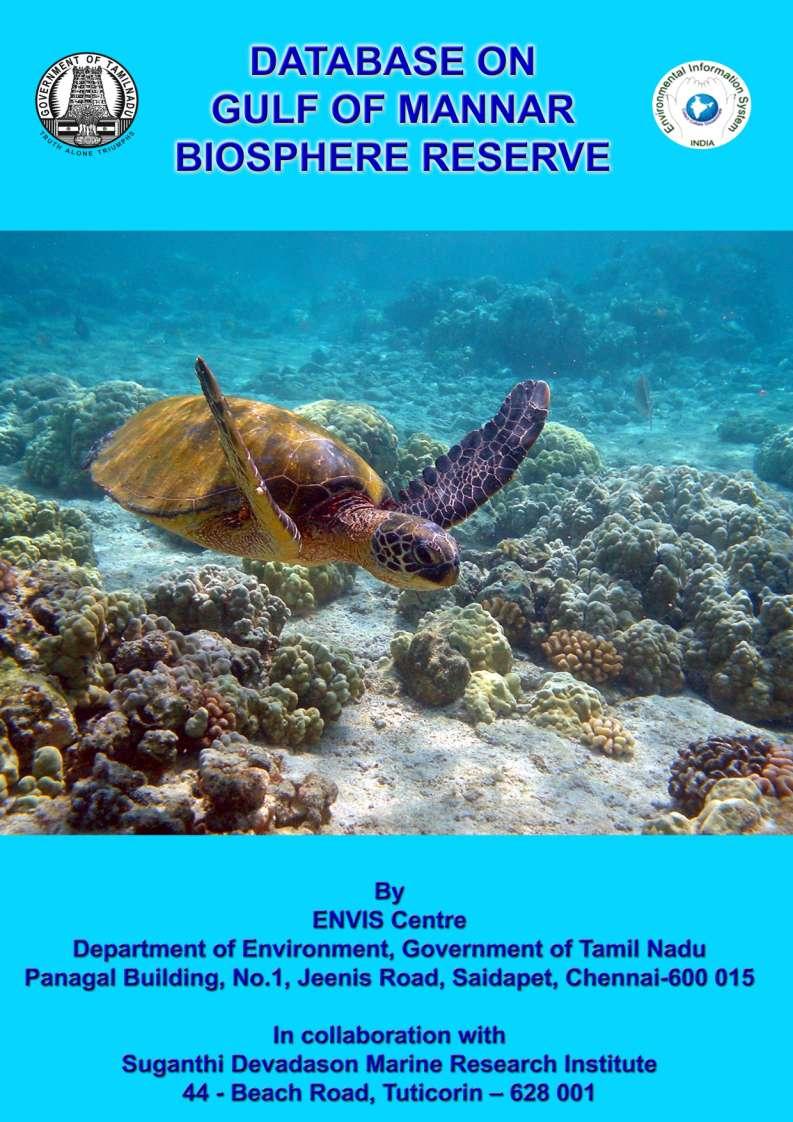
2 DATABASE ON GULF OF MANNAR BIOSPHERE RESERVE ENVIS Centre Department of Environment Government of Tamil Nadu Chennai
.")
3 1. Introduction The Gulf of Mannar, the first Marine Biosphere Reserve (GOMMBR) in the South and South East Asia, running down south from Rameswaram to Kanyakumari in Tamil Nadu, India is situated between Longitudes E to E and along Latitudes from 8035 N to 9025 N (Figs.1 & 2). This Marine Biosphere Reserve encompasses a chain of 21 islands (2 islands already submerged) and adjoining coral reefs off the coasts of the Ramanathapuram and the Tuticorin districts forming the core zone; the Marine National Park and the buffer zone includes the surrounding seascape and a 10 km strip of the coastal landscape covering a total area of 10,500 Km 2, in the Ramanathapuram, Tuticorin, Tirunelveli and Kanyakumari Districts with a long coastline of Km. The importance of the Gulf of Mannar region dates back to the 2nd Century AD because of its highly productive pearl oyster banks and other religious significance. In India, the Gulf of Mannar region in Tamil Nadu is one of the four major coral reef areas and the others are Gulf of Kutch in Gujarat, Lakhsadweep and Andaman and Nicobar islands. Fig.1: Map showing Tamil Nadu state with Gulf of Mannar location 3
4 Fig.2: Map showing the Gulf of Mannar with 21 islands The Gulf of Mannar has drawn attention of conservationists even before the initiation of the Man and Biosphere (MAB) program by the UNESCO in With its rich biodiversity of about 4223 species of various flora and fauna, part of this Gulf of Mannar between Rameswaram and Tuticoirin covering 21 islands and the surrounding shallow coastal waters has been declared as a Marine National Park in 1986 by the Government of Tamil Nadu and later the first Marine Biosphere Reserve of India in 1989 by the Government of India. Several research organizations like Central Marine Fisheries Research Institute (CMFRI), Suganthi Devadasan Marine Research Institute (SDMRI), Fisheries College and Research Institute, Tuticorin, Madurai Kamaraj University, Zoological Survey of India (ZSI), Anna University, Annamalai University, Wildlife Institute of India (WII) and others have conducted various studies in the Gulf of Mannar maining on the biodiversity which have confirmed the richness of the marine biodiversity in this region. 4
5 Besides key coastal habitats like coral reefs, seagrass beds and mangroves, the Gulf of Mannar Biosphere Reserve supports several globally important species such as the critically endangered Dugong dugon (sea cow), all protected sharks (IWPA, 1972) including whale shark, sea horses, green and hawksbill sea turtles, dolphins and sea cucumbers and several endemic species of Balanoglossus, sea grass, crabs and mangroves. The swamp near the Kodandaraman Temple near Rameswaram gives shelter to a flock of about 10,000 flamingos every year, during the months of December to March along with various many other species of waders and wetland birds. Exploitation of fishery resources in the inshore waters had been the sole occupations for several thousand families living along the coast of Gulf of Mannar for centuries. They have been in such close intimacy with the coastal and marine environment that their life-style, culture and social life all centres around the sea. 2. Ecological characteristics of Gulf of Mannar 2.1 Beach Beaches are extensively developed along the entire coast of Gulf of Mannar except at some places. The shore between Tuticorin to south Sippikulam (2.04 km²), Vaippar and Gundar Rivers (2.56 km²), Gundar and Palar Rivers (2.64 km²), Palar and Kottakkarai Rivers (2.189 km²), Kottakkarai River and Marakkayarpattanam (2.18 km²) southern coastal parts of the Rameswaram Island (2.91 km²) and the western part of the Rameswaram Island from Pamban to Peikkarumbu are observed as a important beach areas in Gulf of Mannar coast. All along the shore the beach is observed to be gently sloping and marked with altered crusts and troughs that are formed due to wave action. There are also good beaches available along the coasts of Tirunelveli and Kanyakumari districts which also a part of the Biosphere Reserve. 2.2 Spit Among the various depositional landform features encountered, the formation of spit is a significant feature of recent age. South of Tuticorin coastal area two spit formations have been observed. It appears to have been built by the sediments brought by long shore current during southwest monsoon. The southwestern shore of Rameswaram has a tongue shaped spit. 5
6 2.3 Beach ridges Beach ridges are moderately undulating terrain features of marine depositional type, formed during Pleistocene to Recent age, in the plains of Gulf of Mannar coast.the coastal areas between Mandapam and East of Vaippar River are covered by well-developed beach ridges. There are twelve beach ridges observed in the region. On the basis of the nature and dispositions of beach ridges, it can be grouped into (i) Beach ridges south of Vaigai River, (ii) Beach ridges between Kotangudi River and Palar River, (iii) Beach ridges between Palar River and Gundar River system, (iv) Beach ridges between Gundar River and Vaippar River and (v) Beach ridges south of Vaippar River. 2.4 Swales and backwater zone Swales and backwater zones are seen between coastal plains of Mandapam and Kottakkarai River; they are branched and arranged in series of linear patterns. They are situated almost parallel to the present coastline. Prominent backwater zones have been observed in the coastal plains between Valinockkam and Vaippar River, Mandapam and Southeast of Tiryppullani near Tinaikkulam. These are divided in to two parts by beach ridges. The coastal areas between Mandapam and Tinaikkulam, Valinokkam and Krishnapuram and North of Terku Mukkaiyur and Tukukankulam consist of prominent and wide backwater zones. These three backwater zones are connected by small, linear and narrow swales to the sea by means of few creeks, which supply water from sea to backwater channels during high tide. The basin bed is composed of silt and mud. The adjacent low lying area, as a part of swale zone is used at present for salt production. 2.5 Mud flat The mudflats are observed near Vaippar River mouth, around Valinokkam backwater lagoon, Kallar River mouth and Gundar River mouth. The area 2.6 Off shore islands and coral reefs A chain of 21 low islands has been observed along the offshore region of Gulf of Mannar Marine National Park.It extends from south of Rameswaram to Tuticorin. All islands are made up of a calcareous framework of dead reef and sand. They have a low and narrow 6
7 sandy coast and some of them have rocky coast. Around all offshore islands, well-developed coral reefs have been noticed. Geomorphologically, coral reefs in this area are of fringing type, though some patch corals are also observed in Keezhakkarai and Tuticorin coasts. The outside GOMMNP, the area between Tuticorin and Kaniyakumari, it is reported vast patch corals, gorgonian and seagrass beds. The patch corals are located about 7-10 km away from the shore, while gorgonian beds are located upto 4-5 km from the shore. However no detailed data available (Patterson et al., 2009). 2.7 Wave cut platform Wave cut platforms are common in the coast of Mandapam, Ramaswamimadam, Pudumatam, Valinokkam etc. At Pudumadam coast, hard and tough sandstone platform occupies the intertidal zone. South of Valinokkam coast very extensive wave cut platform has been observed and erosional features are widely seen. 2.8 Sea cliff and sea cave Along the coast of Gulf of Mannar, cliffs have been observed in Mandapam, Rameswaram, Pudumatam and Appa Island coastal areas. Generally the sea cliff and caves are made up of calcareous sandstone and located at the high water level. Due to intensive wave action on cliffs, at some places, sea caves are formed. Such caves have been observed near Mandapam coastal area and Southwestern and Southern coastal areas of Appa Island. At some places, these features have been destroyed due to slumping of upper cliff materials 2.9 Waterlogged land Water logged lands have been observed around the northern part of Rameswaram Island. In the areas like Pillaikulam, Surantidal and Mangaud, this type of features has been observed. 7
8 2.10 Strandlines In the Gulf of Mannar coast from Tiruppullani to Mandapam, eight series of strandlines in curvilinear form have been observed. The general trend of the strandline is in the east to west direction. In the south of Rameswaram area also, curvilinear strandlines have been observed Currents The current in the area are swift. The sea is rough between April and August. During June to august it is very stormy. It is calm during September to March. The October to December months have North east monsoon with occasional gales. The current movement normally changes depends on monsoon. During Southwest monsoon the current pattern is from south to north and during Northeast monsoon, the current movement is from north to south Soil The soil is typical coastal sand, stream with shingles in places and there are swamps in places in Van Tivu, Kasuwar Island, Poomarichan Island, Pullivasal Island, Krusadai and Shingle islands. Quick sand is seen in places in Mulli and Krusadai Island Geographical/Geomorphological Features The deepest parts of the sea are situated off Valinokkam and off Pamban island. The shallowest part is found north of Tuticorin and extends from Vaipar to Pamban. Some of the geographical and features within the Gulf are biologically noteworthy for their rich variety and the support they provide to sustain uniqueness of the living resources Climates and Rainfall The area comes under the spell of both south-west and north-east monsoon. The south- west monsoon contributes only very little towards the annual rainfall of the area. Rain fall is moderate to heavy during October to mid December with occasional gales. The annual 8
9 rainfall varies from 762 mm. to 1270 mm year to year. The monthly average annual atmospheric temperature varies from 27 0 C to 33 0 C with the maximum and minimum in April/May and January respectively Water resources Fresh water is available only in Nallathanni Tivu as the name of island itself specified. Tolerably good water is available in rainy season and winter in Talaiyari Island, Hare Island and Pullivasal Island though not in abundance. 3. The off shore islands, its ecology, coral diversity and importance in the Biosphere Reserve The ecological conditions of the 21 islands (including two submerged islands) and coral biodiversity as per the Management Plan ( ) documents are detailed below Vaan Island The ground vegetation has halophytic herbs, creepers and grasses. About ¼ area of this island has already become submerged due to the removal of coral reefs. The heavy biotic interference due to its nearness to Tuticorin town and nearby villages and frequent fires caused by fisherman is the main reason for degradation of this island s biodiversity. There are a few depressions on this island and the mangrove species are absent. The open area of this island has been planted with Thespesia, Pungan, Neem, Delonix alata with 35% survival. The live coral cover in this island is considered as fair and the order of dominance of live coral categories is CM>CB>ACB>CF>ACT>CE. The average percentage occurrence of live coral categories of he Vaan Island resulted is ACT 3.26%, ACB 3.71%, CB 5.07%, CE 2.81%, CF 3.45% and CM 12.82%. Among the live coral categories, coral massive (CM) is dominant. The percentage of Acropora and Non-Acropora was recorded as 6.97% and 24.16% respectively. The coral sub massive (CS) was totally absent in Vaan Island. Live corals are seen in the southern side of the island, while the dead corals are found to be as substrate for many types of seaweed. The rubbles are found sprayed on the southern side having 3.04%. The reef flat was dominant by Acropora sp. and Montipora sp., where reef 9
10 slope was dominant by Favia sp., Favites sp., Hydnophora sp., Goniopora sp., Platygyra sp. and Porites sp. Area cover (Km 2 ): Coral Cover (CC) and Dead Coral with Algae (DCA) Km 2 and Dead Coral (DC) Km 2 (Fig.3). 78 o N 8 o Bathymetry: 0-2m 4 Bathymetry: 2-4m 2 Bathymetry: over 4m 0 Van Island DC CC & DCA 8 o km 78 o Fig.3: Map showing distribution of coral reef around Vaan Island (CC- Coral Cover, DCA- Dead Coral with Algae and DC-Dead Coral) 3.2. Koswari Island Prosopis and Salvadora trees are dominant on the terrestrial part of the island. The ground vegetation has herbs, creepers and grasses. Due to excess removal of corals over the last decade, about ¼ of this island is sinking under water. Due to the control exercised on coral mining, fresh coral debris and sand accretions are taking place in other portions also and plant succession with ground vegetation and grasses isestablishing over the newly built up land portions. In a natural depression, good growth of Avicenia species and Suaeda are seen. The Afforestation done during has about 40% survival. Pithacalobium dulce, Vagai, thespesia have come up well. The area surrounding this island is famous for chank due to good sacred chank beds, which attract near by fishermen illegal collection of chanks. 10
11 The live coral cover of this island is considered as poor and the order of dominance of live coral categories is CM>CE>CB>CF>ACB>ACT. The percentage occurrence of live coral categories of this island follows is ACB 1.21%, CB 2.87%, CE 3.51%, CF 1.6%, CM 6.1% and ACT 0.21%. Among the live coral categories, coral massive (CM) is dominant while the coral sub massive (CS) is totally absent in this island. The percentage of Acropora and Non-Acropora is recorded as 1.17% and 14.09% respectively. Illegal mining of corals for the last 2-3 decades have brought deleterious effect on the corals and are responsible for decrease of coral diversity. The percentage of rubbles covers in this island is 7.05%. Live coral cover is seen in the southwest, south and southeast direction of the island. The reef flat consists of live coral colonies including branching types represented by Acropora sp., and Montipora sp while massive types represented by Porites sp., Favitis sp., and Favia sp. seen in the reef crest and reef slopes. Area cover (Km 2 ): Coral Cover (CC) and Dead Coral with Algae (DCA) Km 2 and Dead Coral (DC) 2.73Km 2 (Fig.4). 78 o N 8 o Bathmetry: 0-1m 3 Bathmetry: 1-2m 2 Koswari Island DC 1 0 Bathmetry: 2-3m Bathmetry: over 3m CC & DCA CC & DCA 0 1km 8 o o Fig.4: Map showing distribution of coral reef around Koswari Island (CC- Coral Cover, DCA- Dead Coral with Algae and DC-Dead Coral) 11
12 3.3. Vilanguchalli Island This submerged island looks like a small sand mount due to removal of coral reefs around this island in the past. Currently, good fringing corals have been observed around this island. The live coral cover of this island is considered as poor and the order of dominance of live coral categories is CF>CM>ACT>CE>ACB>CB. The live coral categories of this island resulted is ACT 5.04%, ACB 0.99%, CB 0.91%, CE 3.02%, CF 8.74% and CM 5.62%. Among the live coral categories corals foliose (CF) is dominant, while coral sub massive (CS) is totally absent. The percentage of Acropora and Non-Acropora is recorded as 6.04% and 18.30% respectively. The massive corals are seen in south and southeastern direction of the submerged island, while table coral are seen in western direction. Most of the dead coral boulders are covered with algae. The common coral species seen in this island are Acropora sp., Turbinaria sp, Platygyra sp and Porites sp. Area cover (Km 2 ): Coral Cover (CC) and Dead Coral with Algae (DCA) 0.98 Km 2 and Dead Coral (DC) 1.35Km 2 (Fig.5). 78 o Vilanguchalli Island (submerged) N 8 o Bathmetry: 0-1m CC & DCA CC & DCA DC Bathmetry: 1-2m Bathmetry: 2-3m Bathmetry: 3-4m Bathmetry: over 4m 0 1km 8 o o Fig.5: Map showing distribution of coral reef around Vilanguchalli Island (CC- Coral Cover, DCA- Dead Coral with Algae and DC-Dead Coral) 12
13 3.4. Kariyachalli Island This island which had an original area of ha, had only an estimated ha in 1993 and this might be due to excessive removal of corals from this island which has resulted in submergence of some portions. This island has scanty vegetation at present consisting of grasses, climbers, few Salvadora and few Prosopis trees. The live coral cover of this island is considered as fair and the order of dominance of live coral categories is CM>CF>ACT>ACB>CB>CE. The average percentage occurrence of live coral categories is ACT 6.19%, ACB 5.03%, CB 4.18%, CE 3.23% CF 7.24% and CM 20.73%. This island contains higher percentage of live corals when compared with the other islands in the Tuticorin group. 78 o N 8 o Bathmetry: 0-1m 3 Kariyachalli Island DC Bathmetry: 1-2m Bathmetry: 2-3m Bathmetry: over 3m CC & DCA CC & DCA 0 1km 8 o o Fig.6: Map showing distribution of coral reef around Kariyachalli Island (CC- Coral Cover, DCA- Dead Coral with Algae and DC-Dead Coral) Among the live coral categories, coral massive (CM) is the dominant, while coral sub massive (CS) is totally absent. The percentage of Acropora and Non-Acropora is recorded as 11.23% and 35.37% respectively. The percentage of rubble covers in this island is 4.75% and dead coral with algae are found as rim along the shoreline. The reef flat zones have branching forms of Acropora sp. and Montipora sp., while the reef crest and reef slope consist of dominantly massive corals such as Favia sp, Favites sp, Hydnophora sp, Platygyra sp., Goniastrea sp., Symphyllia sp. and Goniopora sp,. Sea grass beds are seen outside of the coral reef along southern side of the island. The sea grass, Thalassia sp is a common species 13
14 in this island followed by the sparse distribution of Halimeda sp. Better diversity of the coral species is recorded in this Island, when compared to the other 3 islands in the Tuticorin group. Area cover (Km 2 ): Coral Cover (CC) and Dead Coral with Algae (DCA) 3.37 Km 2 and Dead Coral (DC) 1.63Km 2 (Fig.6) Upputhani Island This island of around 30 ha area has good natural growth of vegetation. Thespesia and neem are the main tree species and are growing from cut stumps. The large depression in the southern side of the island caused by coral mining about two decades back, has stagnation of rain water and sea water and has become a natural heronry for sea birds. There is good growth of Avicenia around this depression. There are good deposits of coral debris due to stoppage of coral removal. Patch and fringing coral reefs are also giving protection to the island shores. Reef developments are extensive on the southeast to southwest direction of the island. The live coral cover of this island is considered as fair and the order of dominance of life form categories is CM>CE>CB>ACB>ACT>CF. The percentage occurrence of life forms categories is CM 11.69%, CE 4.03%, CB 3.88%, ACB 2.78%, ACT 2.52% and CF 0.23%. The percentage of Acropora and Non-Acropora is recorded as 5.29% and 19.83% respectively. The life form has many corals represented by certain non-branching forms of Porites sp., Favia sp., and Goniastea sp., and branching form of Acropora sp. and Montipora sp. Most of the dead coral boulders are covered with macro algal assemblage on northeastern direction with Sargassum gracillaria sp., Calurepa sp, and Padina sp. dominated at the reef crest area. Area cover (Km 2 ): Coral Cover (CC) and Dead Coral with Algae (DCA) 2.12 Km 2 and Dead Coral (DC) 3.92 Km 2 (Fig.7). 14
15 78 o N 9 o Bathmetry: 0-1m 3 2 Bathmetry: 1-2m Bathmetry: 2-3m Upputhanni Island 1 0 Bathmetry: over 3m DC CC & DCA 0 1km 9 o o Fig.7: Map showing distribution of coral reef around Upputhanni Island (CC- Coral Cover, DCA- Dead Coral with Algae and DC-Dead Coral) 5.6. Puluvinichalli Island This island has an area of about 6 ha. and fairly good halophytic vegetation. Thespesia, Salvadora and Neem have come up well from cut stumps. There are no mangroves or natural depressions on this island. There has been no afforestation activity on this island so far. The live coral cover of this island is considered as good and the order dominance of live coral categories is ACB>CM>CE>CE>CB>ACT. The average percentage occurrence of live coral categories is ACB 30.79%, CM 15.17%, CE 3.95%, CF 3.63%, CB 3.27% and ACT 1.98%. Among the live coral categories, Acropora branching (ACB) is the dominant. The percentage of Acropora and Non-Acropora is recorded as 32.77% and 26.01% respectively. 15
16 78 o N 9 o Bathmetry: 0-1m Bathmetry: 1-2m Bathmetry: 2-3m Bathmetry: 3-4m Bathmetry: over 4m Pulivinichalli Island CC & DCA DC 0 1km 9 o o Fig.8: Map showing distribution of coral reef around Pulivinichalli Island (CC- Coral Cover, DCA- Dead Coral with Algae and DC-Dead Coral) The live corals are present in the southeast to southwest direction of this island. This shallow reef is changing from Acropora sp. dominance to Porites sp. dominance. Reef crest and reef slope consists of Coral Massive (CM), Acropora Branching (ACB) and Acropora Table (ACT). The dominant corals of this island are represented by Acropora sp, Montipora sp, Favia sp Platygyra sp, Galaxea sp Pocillopora sp, and Goniastrea sp. The reef crest often gets exposed during low tide. Good diversity of the coral species is recorded in this Island, when compared to the other Vembar group Islands. Area cover (Km 2 ): Coral Cover (CC) and Dead Coral with Algae (DCA) 2.15 Km 2 and Dead Coral (DC) 2.21 Km 2 (Fig.8). 16
17 5.7. Nallathanni Island With an area of about 110 ha, it is situated about 2 km from Mundal fishing village. In about 35 ha. of area planted by the Maraickayar family, there were 1600 coconut and 2000 palmyra palms in 1993 but now there are around 150 coconut trees and 300 palmyra palms present which are taken care by a lady who takes care the Muniswaran temple built in this island. Many locals come to this temple for worship by private boats. Every year, in the month of March, this temple festival attracts nearly pilgrims from nearby fishing villages. There is heavy growth of Prosopis on this island. Big trees of Tamarind, Ficus, Thespesia, Salvadora and coconut were seen with top portions dried up. This is the only island where good potable water is available at upto 5 depth in one portion of the island. 78 o N 9 o Bathmetry: 0-1m DCA Nallathanni Island Bathmetry: 1-2m Bathmetry: 2-3m Bathmetry: over 3m 0 DC DC CC & DCA 0 1km 78 o o Fig.9: Map showing distribution of coral reef around Nallathanni Island (CC- Coral Cover, DCA- Dead Coral with Algae and DC-Dead Coral) The live coral cover of this island is considered as poor and the order of dominance of live coral categories is CM>CE>CF>ACT>CB>ACB. The average percentage occurrence of live coral categories is CM 7.76%, CE 1.92%, CF 1.42%, ACT 0.51%, CB 0.30% and ACB 0.16%. The percentage of Acropora and Non-Acropora was recorded as 0.66% and 11.40% respectively. Among the live coral categories, coral massive (CM) is dominant while 17
18 the coral sub massive (CS) is totally absent. The northeast and southeast directions of the island have dead coral with algae at the reef flat area. Very few species of live corals are seen in this island, which includes Porites sp. and Acropora sp. in the reef flat area of southern direction. Area cover (Km 2 ): Coral Cover (CC) and Dead Coral with Algae (DCA) 7.77 Km 2 and Dead Coral (DC) 4.55 Km 2 (Fig.9) Anaippar Island This has an area of 11 ha. There are good coral reefs and patch coral formations around the island. There are no mangroves along the shore of the island. There are man made depressions in the island where once salt making was done and around this, Avicenia avicinalis growth is present. The vegetation mainly consists of prosophis and occasionally Salvadora. There are patches of depressions where rain water and salt water accumulate during monsoon resulting in stagnation. Human interference was not much on this island though it is near to Valinokkam because of absence of good quality sea weeds. 78 o N 9 o Bathmetry: 0-2m Anaipar Island 3 Bathmetry: 2-4m 1 Bathmetry: over 4m -1 DC CC & DCA 0 1km 9 o o Fig.10: Map showing distribution of coral reef around Anaipar Island (CC- Coral Cover, DCA- Dead Coral with Algae and DC-Dead Coral) 18
19 The live coral cover of this island is considered as fair and the order of dominance of live coral categories is CM> ACT> CF> CE> ACB> ACF> CS> ACD> ACE. The average percentage occurrence of live coral categories is CM 14.38%, ACT 11.74%, CF 5.91%, CE 5.45%, ACB 4.29%, ACF 3.53%, CS 2.08% and ACD 0.41%. The percentage of Acropora and Non-Acropora is recorded as 20.11% and 27.81% respectively. Among the live coral categories, Coral massive (CM) 14.38% is the dominant. The reef flat on south and southeastern side of the island consists of live branching corals and non-branching coral. The coral population of this island is represented by Acropora sp., Porites sp., Favia sp., Favities sp., Platygyra sp., Leptoria sp., Echinopora sp. and Montipora sp. Area cover (Km 2 ): Coral Cover (CC) and Dead Coral with Algae (DCA) 1.91 Km 2 and Dead Coral (DC) 2.15 Km 2 (Fig.10) Valimunai Island This has an area of 6.72 ha, and the present vegetation is mostly of Salvadora and Prosopis trees and grasses is also present to some extent. There are no depressions and mangroves are absent. There are evidences of heavy biotic interference on this island. There is good reef network surrounding the island but the island shores are not being protected with any mangrove vegetation. Occasional patches of Pemphis acidula are seen. 78 o N 9 o Bathmetry: 0-1m Bathmetry: 1-2m DC Bathmetry: 2-3m Bathmetry: over 3m CC & DCA Valimunai Island CC & DCA 0 1km 9 o o Fig.11: Map showing distribution of coral reef around Valimunai Island (CC- Coral Cover, DCA- Dead Coral with Algae and DC-Dead Coral) 19
20 The live coral cover of this island is considered as fair and the order of dominance of live coral categories is CM> ACB> ACT> CE> CS> CF> ACE> ACD> ACF. The average percentage occurrence of live coral categories is CM 13.94%, ACB 7.78%, ACT 4.87%, CE 1.44%, CS 0.39%, CF 0.34%, ACE 0.28%, ACD 0.20% and ACF 0.15%. The percentage of Acropora and Non-Acropora is recorded as 13.29% and 16.11% respectively. Among the live coral categories, Coral Massive (CM) 13.94% is dominant. Branching and non-branching live corals are seen on reef flat zone of southwest to southeast direction of the island. The coral population in this island is represented by Porites sp., Favia sp., Favities sp., Acropora sp., Montipora sp., Pocillopora sp., and Goniastrea sp. Area cover (Km 2 ): Coral Cover (CC) and Dead Coral with Algae (DCA) 2.83 Km 2 and Dead Coral (DC) 1.11 Km 2 (Fig.11) Poovarsanpatti Island This island is submerged about 3 decades ago due to excessive quarrying of corals from its surroundings. The area where island was said to be present ( N E to N E) in the past, is now submerged at a depth of about 1.5M during low tide. This is surrounded by a good growth of corals, sea grass and sea weed beds. A shifting sand mound is present near this island, which is seen during low tides. 78 o N 9 o Bathmetry: 0-1m 3 Bathmetry: 1-2m 2 1 Bathmetry: 2-3m Bathmetry: over 3m 0 CC & DCA 0 1km 9 o o Fig.12: Map showing distribution of coral reef around Poovarasanpatti Island (CC- Coral Cover, DCA- Dead Coral with Algae and DC-Dead Coral) 20
21 The live coral cover of this island is considered as fair and the order of dominance of live coral categories is ACD>ACT>ACB>CM. The average percentage occurrence of live coral categories is ACD 16.35%, ACT 5.31%, ACB 3.85%, CM 3.57%. The percentage of Acropora and Non-Acropora is recorded as 25.50% and 3.57% respectively. Among the live coral categories, Acropora digtata (ACD) is the dominant with 16.35%. The coral population in this island is represented by Porites sp., Favia sp., Goniasterea sp., Acropora sp. and Montipora sp. Area cover (Km 2 ): Coral Cover (CC) and Dead Coral with Algae (DCA) 1.48 Km 2 (Fig.12) Appa Island It is in 2 blocks which is separated by a sand bar with shallow water permitting crossing on foot between the two blocks. The main vegetation is Prosophis with occasional Salvadora and Thespesia. There are no mangrove patches and Pemphis growth to protect the island shores. One part of the island is of coral base with sand deposition where it is entirely Prosophis growth. In the other part due to constant wave action, the sand has been washed away and the underlying coral rocks have been exposed to wave action. There is good coral reef growth in continuation to the island. 78 o N 9 o Bathmetry: 0-1m 3 Bathmetry: 1-2m CC & DCA DC CC & DCA Bathmetry: 2-3m Bathmetry: over 3m Appa Island 0 1km 9 o o Fig.13: Map showing distribution of coral reef around Appa Island (CC- Coral Cover, DCA- Dead Coral with Algae and DC-Dead Coral) 21
22 The live coral cover of this island is considered as good and the order dominance of live coral categories is ACD> CF> ACB> CB> CM> ACF> CS> ACE> ACT. The average percentage occurrence of live coral categories is ACD 17.24%, CF 13.53%, ACB 10.63%, CB 7.73, CM 4.83%, ACF 3.11, CS 1.86, ACE 0.35% and ACT 0.32%. The percentage of Acropora and Non-Acropora is recorded as 31.75% and 27.95% respectively. Among the live coral categories, Acropora digtata (ACD) is the dominant (17.24%). Branching and nonbranching live corals are seen on the reef flat zone of southeast and northwest direction of the island. The coral population in this island is represented by Galaxea sp., Porites sp., Favia sp., Favities sp., Platygyra sp., Leptoria sp., Acropora sp., Pocilopora sp., Montipora sp., Echinopora sp., Merulina sp., Pavona sp., and Turbinaria sp. Area cover (Km 2 ): Coral Cover (CC) and Dead Coral with Algae (DCA) 4.82 Km 2 and Dead Coral (DC) 0.95 Km 2 (Fig.13) Thalayari Island It is about an hour by boat from Kilakarai. The general growth is mostly littoral vegetation with a small patch of Avicenia. Most of the island shore is protected by Pemphis acidula only. Thespesia, Salvadora and Pemphis are the predominant tree species at present 78 o N 9 o Bathmetry: 0-1m 2 Thalairi Island Valai Island 1 Bathmetry: 1-2m Bathmetry: over 2m 0 CC & DCA 0 2km 78 o o Fig.14: Map showing distribution of coral reef around Thalaiyari Island (CC- Coral Cover, DCA- Dead Coral with Algae and DC-Dead Coral) 22
23 The live coral cover of this island is considered as fair and the order of dominance of live coral categories is CM> ACB> ACD> ACT> ACF> CS> CE> ACE> CF> CB. The average percentage occurrence of live coral categories is CM 25.43%, ACB 6.59%, ACD 5.41, ACT 3.60%, ACF 3.12%, CS 1.74%, CE 1.57%, ACE 0.86%, CF0.16%, CB 0.05%. The percentage of Acropora and Non-Acropora is recorded as 19.57% and 28.95% respectively. Among the live coral categories, Coral Massive (CM) is the dominant (25.43%). Branching and non-branching live corals are seen on reef flat zone of the island. The coral population in this island is represented by Porites sp., Favia sp., Favities sp., Platygyra sp., Pavona sp., Pocilopora sp., Acropora sp. and Montipora sp. Area cover (Km 2 ): Coral Cover (CC) and Dead Coral with Algae (DCA) 5.90 Km 2 (Fig.14) Valai Island The Valai island has an area of ha. There is a sand bar connecting this to Thalaiyari island. It is has good protection on either side by patch and fringing coral reefs. The shores are protected mostly by good growth of Pemphis acidula. The vegetation is quite good with Salvadora and Thespesia as the most predominant species. Ground level halophytic grass and other flora are also good. There are small patches of vacant areas with no tree growth. 78 o N 9 o Bathmetry: 0-1m 2 Bathmetry: 1-2m CC & DCA Valai Island 1 Bathmetry: over 2m 0 Thalairi Island DC 0 1km 9 o o Fig.15: Map showing distribution of coral reef around Valai Island (CC- Coral Cover, DCA- Dead Coral with Algae and DC-Dead Coral) 23
24 The live coral cover of this island is considered as fair and the order of dominance of live coral categories is CM>ACD>ACB>ACT>CE>CF>CB. The average percentage occurrence of live coral categories is CM 19.10%, ACD 8.29%, ACB 6.93, ACT 6.46%, CE 3.71%, CF 3.57%, CB The percentage of Acropora and Non-Acropora is recorded as 21.67% and 26.74% respectively. Among the live coral categories, Coral Massive (CM) is the dominant (19.10%). Branching and non-branching live corals are seen on the reef crest and reef slope of northwest direction of the island. The coral population in this island is represented by Porites sp., Favia sp., Favities sp., Goniastrea sp., Pocilopora sp., Acropora sp. and Montipora sp. Area cover (Km 2 ): Coral Cover (CC) and Dead Coral with Algae (DCA) 1.20 Km 2 and Dead Coral (DC) 1.41 Km 2 (Fig.15) Mulli Island The area is ha and the island is protected by both patch and fringing coral reefs. The vegetation is sparse with mostly ground level grasses, climbers. Salvadora and Thespesia are present which are seen sprouting from heavily lopped 2 year old stumps. There are two depressions inside the island and around the large depression, good growth of Avicenia avicinalis is seen. 78 o N 9 o Bathmetry: 0-1m 2 Mulli island 1 Bathmetry: 1-2m Bathmetry: over 2m DC 0 CC & DCA 0 1km 78 o o Fig.16: Map showing distribution of coral reef around Mulli Island (CC- Coral Cover, DCA- Dead Coral with Algae and DC-Dead Coral) 24
25 The live coral cover of this island is considered as fair and the order of dominance of live coral categories is ACD>CM>ACB>CB>ACT>CS>CE. The average percentage occurrence of live coral categories is ACD 25.25%, CM 6.23%, ACB 5.73%, CB 4.07%, ACT 1.41%, CS 0.10%, CE 0.04%. The percentage of Acropora and Non-Acropora is recorded as 22.03% and 20.00% respectively. Among the live coral categories, Acropora digtata (ACD) is the dominant (25.25%). Branching and non-branching live corals are seen on the reef flat of northeast, southeast and southwest direction of the island. The coral population present in this island is represented by Porites sp., Favia sp., Favities sp., Platygyra sp., Echinopora sp., Pavona sp., Pocilopora sp., Acropora sp. and Montipora sp. Area cover (Km 2 ): Coral Cover (CC) and Dead Coral with Algae (DCA) 2.21 Km 2 and Dead Coral (DC) 1.12 Km 2 (Fig.16) Hare Island This island is frequented by local people. In total, about 2050 coconut trees and 1800 Palmyra trees are available in this island. There are good Pemphis acidula growth skirting the periphery. There is a large depression surrounded by mangrove vegetation and which is a beautiful heronry where plenty of sea birds congregate. Prosophis and other halophytic vegetation are also good. The live coral cover of this island is considered as fair and the order of dominance of live coral categories is ACD>CM>ACB>ACT>CB>CS>ACF> CF>ACE. The average percentage occurrence of live coral categories is ACD 12.31%, CM 5.86%, ACB 5.64%, ACT3.88%, CB 2.02%, CS 1.03%, ACF 1.02%, CF 0.48%, ACE 0.32%. The percentage of Acropora and Non-Acropora is recorded as 23.18% and 9.40% respectively. Among the live coral categories, Acropora digitata (ACD) is the dominant (12.31%). 25
26 79 o N 9 o Bathymetry: 0-1m 2 Bathymetry: 1-2m CC & DCA CC & DCA 1 Bathymetry: over 2m 0 Hare island CC & DCA DCA CC & DCA DC CC & DCA km 9 o o Fig.17: Map showing distribution of coral reef around Hare Island (CC- Coral Cover, DCA- Dead Coral with Algae and DC-Dead Coral) Two patches of mono-specific group of Acroporides are seen along the southern side of the reef flat. Dead coral with algae (DCA) is seen on the reef flat of southwest direction of the island. Patches of live coral and dead coral (DCA) are seen along the north and northeast direction of the island. The coral population in this island is represented by Porites sp., Favia sp., Favities sp., Platygyra sp., Acropora sp., Echinopora sp. and Montipora sp. Area cover (Km 2 ): Dead Coral with Algae (DCA) 5.35Km 2, Coral Cover (CC) and Dead Coral with Algae 6.56 Km 2 and Dead Coral (DC) 1.86 Km 2 (Fig.17) Manoli Island This is an island with beautiful mangrove vegetation and Pemphis acidula along the periphery. There is good natural vegetation of Salvadora, Thespesia etc. There are natural depressions acting as heronries for sea birds. There is a large sand bar connecting Manoli Island to Manoliputti Island. and it has formed very recently. It is getting colonized by natural vegetation. 26
27 79 o N 9 o Bathymetry: 0-1m Bathymetry: 1-2m 1 Bathymetry: over 2m 0 CC & DCA Manoli Island DCA Manoliputti Island 0 1km 9 o o Fig.18: Map showing distribution of coral reef around Manoli Island (CC- Coral Cover and DCA- Dead Coral with Algae) The live coral cover is considered as fair and the order of dominance of live coral categories is ACB>ACD>CM>CF>ACF>ACT>CB>CE> CS. The average percentage occurrence of live coral categories of Manoli Island is ACB 13.18%, ACD 8.57%, CM 7.12%, CF 6.45, ACF 2.28%, ACT 1.98%, CB 0.75%, CE 0.23% and CS 0.10%. The percentage of Acropora and Non-Acropora is recorded as 26.02% and 14.66% respectively. Among the live coral categories, Acropora Branching (ACB) is dominant (13.18%). The reef crest and reef slope on the northern side of the island consists of branching corals and nonbranching coral. The coral population in this island is represented by Porites sp., Favia sp., Favities sp., Platygyra sp., Acropora sp., Echinopora sp. and Montipora sp. Area cover (Km 2 ): Coral Cover (CC) and Dead Coral with Algae (DCA) 2.35 Km 2 and Dead Coral with Algae (DCA) 1.97 Km 2 (Fig.18). 27
28 5.17. Manoliputti Island This is a very small-island separated by a shallow channel from Manoli. There is fairly good natural vegetation on this island including Pemphis and occasional mangrove species. 79 o N 9 o Bathymetry: 0-1m 2 Bathymetry: 1-2m 1 Bathymetry: over 2m 0 Manoli Island CC & DCA DC Manoliputti Island 0 1km 9 o o Fig.19: Map showing distribution of coral reef around Manoliputti Island (CC- Coral Cover, DCA- Dead Coral with Algae and DC-Dead Coral) The live coral cover of this island is considered as fair and the order of dominance of live coral categories is CM>ACT>ACD. The average percentage occurrence of live coral categories of is CM 20.35%, ACT 4.04%, and ACD 2.87%. The percentage of Acropora and Non-Acropora is recorded as 6.92% and 20.25% respectively. Among the live coral categories, Coral massive (CM) is the dominant (20.35%). The reef flat on the northeast side of the island consists of non-branching coral, which is dominant by Porites sp. colonies. The coral population in this island is represented by Porites sp., Favia sp., Favities sp., Acropora sp., Montipora sp. and Pocillopora sp. Area cover (Km 2 ): Coral Cover (CC) and Dead Coral with Algae (DCA) 1.83 Km 2 and Dead Coral (DC) 1.57 Km 2 (Fig.19). 28
29 5.18. Poomarichan Island The Pullivasal and Poomarichan islands are almost in the form of a horse shoe shape with the land connection during low tides and in this area a good aviary of marine birds like Seagulls, Plovers, Curlews, Terns etc can be seen. Mangrove species like Rhizophora, Ceriops are also seen in this island. Pemphis growth is very good in the intertidal region and it is a major species which is protecting the island shore line from getting eroded. 79 o Poomarichan Island DC CC & DCA N Kurusadai Island 9 o Bathymetry: 0-1m Bathymetry: 1-2m Bathymetry: 2-3m Bathymetry: over 3m -1 Pullivasal Island 0 1km 9 o o Fig.20: Map showing distribution of coral reef around Poomarichan Island (CC- Coral Cover, DCA- Dead Coral with Algae and DC-Dead Coral) The live coral cover of this island is considered as fair and the order dominance of live coral categories is CM> CF> ACD> ACT> CE> CB> CS> ACF> ACE> ACB. The average percentage occurrence of live coral categories is CM 15.80%, CF 2.13%, ACD 1.74%, ACT 1.69%, CE 1.64%, CB 1.28%, CS 0.51%, ACF 0.49% and ACB 0.05%. The percentage of Acropora and Non-Acropora is recorded as 4.20% and 21.34% respectively. Among the live coral categories, Coral Massive (CM) is dominant (15.80%). The reef crest on the north and northeast side of the island consists of branching and non-branching coral, which is dominant by Porites sp. The coral population in this island is represented by Porites 29
30 sp., Favia sp., Favities sp., Platygyra sp., Acropora sp., Echinopora sp. and Montipora sp. Area cover (Km 2 ): Coral Cover (CC) and Dead Coral with Algae (DCA) 3.16 Km 2 and Dead Coral (DC) 0.96 Km 2 (Fig.20) Pullivasal Island The Pullivasal island has a good vegetation at present and the fringes of the island in the intertidal region has mainly the mangrove associate, Pemphis and on the inside, Prosophis, Palmyrah, Thespesia and other miscellaneous species are found. It is found that Pemphis growth is very good in the intertidal region and it is a major species which is protecting the island shore line from getting eroded. Natural regeneration of mangrove is very good and the vegetation is also fairly good. 79 o Poomarichan Island Pullivasal Island CC & DCA N Kurusadai Island 9 o Bathymetry: 0-1m Bathymetry: 1-2m Bathymetry: 2-3m Bathymetry: over 3m DC 0 1km 9 o o Fig.21: Map showing distribution of coral reef around Pullivasal Island (CC- Coral Cover, DCA- Dead Coral with Algae and DC-Dead Coral) The live coral cover of this island is considered as fair and the order dominance of live coral categories is CM> ACD> ACT> CB> ACB> ACF> CF> CS> CE> ACE. The average percentage occurrence of live coral categories is CM 12.12%, ACD 11.86%, ACT 30
31 5.92%, CB 5.17%, ACB 3.48%, ACF 3.40%, CF 3.20%, CS 0.59%, CE 0.44% and ACE 0.19%. The percentage of Acropora and Non-Acropora is recorded as 24.85% and 21.52% respectively. Among the live coral categories, Coral Massive (CM) is the dominant (12.12%). The reef crest and reef slope on the north and northwest side of the island consists of branching and non-branching coral, which is mainly dominant by Porites sp. colonies. The coral population in this island is represented by Porites sp., Favia sp., Favities sp., Turbinaria sp., Acropora sp., Echinopora sp. and Montipora sp. Area cover (Km 2 ): Coral Cover (CC) and Dead Coral with Algae (DCA) 2.32 Km 2 and Dead Coral (DC) 2.13 Km 2 (Fig.21) Krusadai Island Known traditionally as a paradise for zoological collections, the fauna around this island has been extensively depleted since many decades. Ptychodora flava, the enteropneust worm and Spirula sp. (Cephalopoda) are unique representatives on this island. There is an old Marine Biological laboratory with few other buildings and a dilapidated old museum. There is good vegetation of Palmyra, Prosopis and other natural species like Thespesia, Salvadora etc. Good coral reef growth is seen around this island. There is a new sand bar developed connecting Kundukal point which is 17 ha. in area. Planting of Salvadora and Thespesia and sowing of Avicenia seeds will help in afforestation of this sand bar. Fencing the linking portion of this sand bar to prevent livestock entry and planting native species will stabilize this sand bar. The live coral cover of this island is considered as fair and the order dominance of live coral categories is ACB>CM>ACT>ACD>CB>CF>ACF. The average percentage occurrence of live coral categories is ACB 14.47%, CM 8.13%, ACT 5.87%, ACD 4.31%, CB 4.29%, CF 0.69% and ACF 0.63%. The percentage of Acropora and Non-Acropora is recorded as 25.27% and 13.04% respectively. Among the live coral categories, Acropora Branching (ACB) 14.47% is dominant. Acropora sp. is seen on the reef flat of northeast direction of the island, while the northwest reef crest consists of massive corals. The coral population in this island is represented by Porites sp., Favia sp., Favities sp., Platygyra sp., Pavona sp., Pachyseris sp., Merulina sp., Acropora sp., Echinopora sp. and Montipora sp. 31
32 Area cover (Km 2 ): Coral Cover (CC) and Dead Coral with Algae (DCA) 4.26 Km 2, Coral Cover (CC) Km 2 and Dead Coral with Algae (DCA) 3.15 Km 2 (Fig.22). 79 o Rameswaram Island 9 o Bathymetry: 0-1m N 2 Bathymetry: 1-2m CC & DCA Kurusadai Island CC 1 0 Bathymetry: over 2m CC & DCA DCA Pulivasal Island 0 1km 9 o o Fig.22: Map showing distribution of coral reef around Krusadai Island (CC- Coral Cover, DCA- Dead Coral with Algae and DC-Dead Coral) Shingle Island This has an area of about 13 ha. and has a heavy deposition of coral debris built up year after year. There is no vegetation skirting the periphery. Mangrove growth is seen only in a small depression in the northern corner of the island. There were no tree growth and good vegetation except Pemphis spp due to heavy anthropogenic pressure since it is nearer to the shore. This island seems to be known for open vegetation mainly covered with grasses. The live coral cover of this island is considered as fair and the order dominance of live coral categories is ACD>ACB>CM>ACT>CB>ACF>CE>CS. The average percentage occurrence of live coral categories of Shingle Island is ACD 18.44%, ACB 11.75%, CM 4.35%, ACT 3.98%, CB 2.86%, ACF 2.67%, CE 0.76% and CS 0.13%. The percentage of Acropora and Non-Acropora is recorded as 20.11% and 27.81% respectively. Among the live 32
33 coral categories, Coral Massive (CM) 14.38% is dominant. The reef flat of the entire island consists of branching and non-branching coral, which is mainly dominant by Montipora sp. colonies. The coral population in this island is represented by Porites sp., Favia sp., Favities sp., Platygyra sp., Acropora sp., Echinopora sp. and Montipora sp. Area cover (Km 2 ): Coral Cover (CC) and Dead Coral with Algae (DCA) 2.16 Km 2, Dead Coral (DC) Km 2 and Dead Coral with Algae (DCA) 0.91 Km 2 (Fig.23). 79 o o Kursadai Island Shingle Island N 2 Bathymetry: 0-1m Bathymetry: 1-2m 1 CC & DCA Bathymetry: over 2m DCA DC 0 CC & DCA 0 0.5km 9 o o Fig.23: Map showing distribution of coral reef around Shingle Island (CC- Coral Cover, DCA- Dead Coral with Algae and DC-Dead Coral) 33
34 The following Table - 1 gives the details of Live coral cover, degraded area in Gulf of Mannar Islands in 2005 (Patterson et al., 2007) Sl. No. Island Live coral cover (%) Live Coral Cover Area (km 2 ) including dead Degraded Area (Km 2 ) coral with algae (DCA) with recruits 1. Shingle Krusadai Pullivasal Poomarichan Manoliputti Manoli Hare Mulli Valai Thalaiyari Appa Poovarasanpatti Valimunai Anaipar Nallathanni Puluvinichalli Upputhanni Kariyachalli Vilanguchalli Koswari Vaan Total Table 1: Live coral cover, degraded area in Gulf of Mannar Islands in 2005 (Patterson et.al., 2007) 34
35 4. Biodiversity profile of the Gulf of Mannar The biodiversity profile of Gulf of Mannar is given below based on the publication titled Coastal and Marine Biodiversity of Gulf of Mannar, Southeastern India - A comprehensive updated species list by Gulf of Mannar Biosphere Reserve Trust (Balaji et al., 2012). Biodiversity plays a vital role in maintaining the health and stability of earth s environment. Biodiversity issues have become increasingly important as the human population grows and the demand for natural resources increases as it represents an important economic resource. Considering the importance of marine biodiversity conservation, the United Nations declared Marine Biodiversity as the theme for the International Day for Biological Diversity in The Gulf of Mannar region is enriched with productive habitats such as coral reefs, seagrasses, mangroves, estuaries, rocky shores and sandy beaches. The diverse nature of ecosystems in the Gulf of Mannar supports a wide variety of significant species including 181 species of seaweeds,15 species of seagrasses,117 species of corals, 158 species of arthropods, 856 species of molluscs, 1147 species of finfishes, 5 species of sea turtles apart from the seasonally migrating marine mammals like whales, dolphins, porpoises and turtles. A unique endemic species of Balanoglossus - Ptychodera fluva, a living fossil that links invertebrates and vertebrates, has been recorded only here at Kurusadai Island. Even though Gulf of Mannar is one of the biologically rich areas in the world, it has been exploited heavily over the past 3-4 decades. The human induced threats to biodiversity are mainly overexploitation of marine resources, habitat destruction, marine pollution and destructive fishing. Moreover due to the aforementioned human induced threats coupled with mining of corals, the fishery potentials of this region have been significantly reduced. The number of chanks collected from this province started dwindling slowly from 1.67 million in 1982 to 0.03 million in As per popular quotes by many research organizations and the scientific communities, more than 3,600 species of flora and fauna have been identified in the Gulf of Mannar area. Through searching and researching, information once thought to be non-existent were identified. Presently, a total of 4223 species has been recorded surpassing the usually cited number of 3600 species (addition of 623 species). This updated species list on the biodiversity of Gulf of Mannar will not only provide the baseline information on the number 35
36 of species of organisms identified so far, but also help the researchers and conservation managers to prepare strategies for effective conservation of these precious resources. Table 2 provides the updated biodiversity check list of Gulf of Mannar. Sl.No. Group Species Number 1. Protista Phytoplankton Seaweeds Seagrass Mangrove Flowering Plants Zooplankton Porifera Coelentrata Nematoda Platyhelminthes - Trematoda Annelida - Polychaeta Bryozoa Chaetognatha Arthropoda Echinodermata Mollusca Tunicata - Ascidacea Tunicata - Thaliacea Hemichordata Cephalochordata Pisces Reptiles Turtles Reptiles - Snakes Aves Marine Mammals 7 Total 4223 Table 2: Updated biodiversity check list of Gulf of Mannar 36


37 4.1. Key coastal habitats and endangered / threatened fauna Coral Reefs Coral reef system is known as rain forest of the sea. They play an important role in global biochemical processes and are also important breeding, spawing, nesting, and feeding areas for many economically important varieties of fishes and other marine organisms. Coral reefs act as a barrier against wave action along coastal areas thus preventing coastal erosion. The people living along the coast obtain a considerable proportion of their food and earnings from the productivity of coral reefs. There are 117 coral species identified so far in Gulf of Mannar (Patterson at al., 2007). They belong to 40 genera and 14 families. Of this, 106 species grouped in 30 genera are hermatypic and 11 species grouped in 10 genera are ahermatypic. The conspicuous species belong to the families Acroporidae, Poritidae and Faviidae. Reefs in Gulf of Mannar are developed around a chain of 21 uninhabited islands that lie along the 140 km stretch between Tuticorin and Rameswaram of Tamilnadu, Southeast coast of India. These islands are located between latitude 8 o 47 N and 9 o 15 N and longitude 78 o 12 E and 79 o 14 E and the average distance of these islands from mainland is about 8 km. They are a part of the Mannar Barrier reef, which are 140 km long and 25 km wide between Pamban and Tuticorin. Different types of reef forms such as shore, platform, patch and fringing type are observed in the Gulf of Mannar. The islands have fringing and patch reefs around them. Narrow fringing reefs are located mostly at a distance of 50 to 100 m from the islands. On the other hand, patch reefs rise from depths of 2 to 9 m and extend to 1 to 2 km in length with width as much as 50 meters. Reef flat is extensive in almost all the reef areas 37

38 in the Gulf of Mannar. The coral reefs in the Gulf of Mannar was degraded due to human interference such as coral mining, destructive fishing methods, seaweed collection, commercial shell collection, introduction of exotic seaweed cultivation, changing land use practices, deforestation and industrial waste input etc. and natural activities like monsoon, wave action, ocean current and tides were identified as the agents that increase the sedimentation and turbidity in coastal waters of Gulf of Mannar. LIST OF SCLERACTINIAN CORALS OF GULF OF MANNAR, SOUTHEASTERN INDIA PHYLUM : COELENTERATA Frey and Leuckart, 1847 Subphylum : CNIDARIA Hatschek, 1888 Class : ANTHOZOA Ehrenberg, 1834 Subclass : ZOANTHARIA de Blainville, 1830 Order : SCLERACTINIA Bourne, 1900 I Suborder : ASTROCOENIINA Vaughan and Wells, 1943 Family : POCILLOPORIDAE Gray, Genus: POCILLOPORA Lamarck, Pocillopora damicornis (Linnaeus, 1758) * 2. Pocillopora verrucosa (Ellis and Solander, 1786) * 3. Pocillopora eydouxi Milne Edwards and Haime, 1860 * 2. Genus: MADRACIS Milne Edwards and Haime, Madracis interjecta v. Marenzeller, 1906 * (= Madracis kirbyi, Veron and Pichon, 1976) Family : ACROPORIDAE Verrill,
39 3. Genus: ACROPORA Oken, Acropora formosa (Dana, 1846) * 6. Acropora intermedia (Dana, 1846) ** 7. Acropora valenciennesi (Milne Edwards and Haime, 1860) * 8. A. microphthalma ( Verrill, 1869)* 9. Acropora sp.novo ** 10. Acropora corymbosa (Lamarck,1816) * 11. Acropora nobilis (Dana, 1846) * 12. Acropora humilis (Dana, 1846) * 13. Acropora valida (Dana, 1846) * 14. Acropora hemprichi (Ehrenberg, 1834) ** 15. Acropora hyacinthus (Dana, 1846) * 16. Acropora stoddarti Pillai and Scheer, 1976 ** 17. Acropora indica (Brook, 1893) * 18. Acropora millepora (Ehrenberg, 1834) * 19. Acropora diversa (Brook, 1893) * 20. Acropora brevicollis (Brook, 1893) * 21. Acropora cytherea (Dana, 1846) * 22. Acropora hebes (Dana, 1846) *** 23. Acropora echinata (Dana, 1846) *** 24. Acropora nasuta(dana, 1846) *** 25. Acropora abrolhosensis (Veron, 1985) *** 26. Acropora pillaii sp. nov ** 4. Genus: MONTIPORA de Blainville, Montipora subtilis Bernard, 1897 * 28. Montipora digitata (Dana, 1846) * 29. Montipora divaricata Bruggemann, 1897 * 30. Montipora venosa (Ehrenberg, 1834) * 31. Montipora spumosa (Lamarck, 1816) * 32. Montipora tuberculosa (Lamarck, 1816) * 33. Montipora monasteriata (Forskal, 1775) * 34. Montipora jonesi Pillai, 1986 * 35. Montipora granulosa Bernard, 1897 * 36. Montipora exserta Quelch, 1886 * 37. Montipora turgescens Bernard, 1897 * 38. Montipora manauliensis Pillai, 1969 * 39. Montipora verrucosa (Lamarck, 1816) * 40. Montipora hispida (Dana, 1846) * 41. Montipora foliosa (Pallas, 1766) * 42. Montipora verrilli Vaughan, 1907 * 43. Montipora aequituberculata Bernard, 1897 *** 44. Montipora sp. Novo *** 39
40 5. Genus: ASTREOPORA de Blainville, Astreopora myriophthalma (Lamarck, 1816) * II Suborder : FUNGIINA Verrill, 1865 Super family : AGARICIICAE Gray, 1847 Family : AGARICIIDAE Gray, Genus: PAVONA Lamarck, Pavona duerdeni Vaughan, 1907 * 47. Pavona varians ( Verrill, 1864) * 48. Pavona decussata (Dana, 1846) * 49. Pavona divaricata Lamarck, 1816 ( = P.venosa) * 7. Genus : PACHYSERIS Milne Edwards and Haime, Pachyseris rugosa (Lamarck, 1801) * Family : SIDERASTREIDAE Vaughan and Wells, Genus : SIDERASTREA de Blainville, Siderastrea savignyana Milne Edwards and Haime, 1850 * 9. Genus : PSEDOSIDERASTREA Yabe and Sugiyama, Psedosiderastrea tayami Yabe and Sugiyama, 1935 * 10. Genus: COSCINARAEA Milne Edwards and Haime, Coscinaraea monile (Forskal, 1775) ** 11. Genus : PSAMMOCORA Dana, Psammocora contigua (Esper, 1797) * Super family : FUNGIICAE Dana, 1846 Family : FUNGIIDAE Dana, Genus: CYCLOSERIS Milne Edwards and Haime, Cycloseris cyclolites (Lamarck, 1801) * Super family : PORITICAE Gray, 1842 Family : PORITIDAE Gray,
41 13. Genus: GONIOPORA de Blainville, Goniopora stokesi Milne Edwards and Haime, 1851 * 57. Goniopora planulata (Ehrenberg, 1834) * 58. Goniopora minor Crossland, 1952 ** 59. Goniopora stutchburyi Wells, 1955 (Goniopora nigra, Pillai,1969) * 60. Goniopora sp. novo *** 14. Genus: PORITES Link, Porites solida (Forskal, 1755) 62. Porites mannarensis Pillai, 1969 * 63. Porites lutea Milne Edwards and Haime, 1851 * 64. Porites lichen Dana, 1846 * 65. Porites exserta Pillai, 1969 * 66. Porites compressa Dana 1846 * 67. Porites complanata *** 68. Porites nodifera *** III Suborder : FAVIINA Vaughan and Wells, 1943 Super family : FAVIICAE Gregory, 1900 Family : FAVIIDAE Gregory, Genus: FAVIA Oken, Favia stelligera (Dana, 1846) * 70. Favia pallida (Dana, 1846) * 71. Favia speciosa (Dana, 1846) * 72. Favia favus (Forskal, 1775) * 73. Favia valenciennesi (Milne Edwards and Haime, 1848) * (= Montastrea valenciennesi) 74. Favia matthaii Vaughan, 1918 ** 16. Genus: FAVITES Link, Favites abdita (Ellis and Solander, 1786) * 76. Favites halicora (Ehrenberg, 1834) * 77. Favites pentagona (Esper, 1794) * 78. Favites melicerum (Ehrenberg, 1834) * 79. Favites complanata (Ehrenberg, 1834) * 80. Favites flexuosa (Dana, 1846) ** 17. Genus: GONIASTREA Milne Edwards and Haime, Goniastrea pectinata (Ehrenberg, 1834) * 82. Goniastrea retiformis (Lamarck, 1816) * 41
42 18. Genus: PLATYGYRA Ehrenberg, Platygyra daedalea (Ellis and Solander, 1786) * 84. Platygyra sinensis (Milne Edwards and Haime, 1849) * 85. Platygyra lamellina (Ehrenberg, 1834) * 86. Platygyra sp. Novo *** 19. Genus: LEPTORIA Milne Edwards and Haime, Leptoria phrygia (Ellis and Solander, 1786) * 20. Genus: HYDNOPHORA Fischer de Waldheim, Hydnophora microconos (Lamarck, 1816) * 89. Hydnophora exesa (Pallas, 1766) * Subfamily : MONTASTREINAE Vaughan and Wells, Genus: LEPTASTREA Milne Edwards and Haime, Leptastrea transversa Klunzinger, 1879 * 91. Leptastrea purpurea (Dana, 1846) * 22. Genus: CYPHASTREA Milne Edwards and Haime, Cyphastrea serailia (Forskal, 1775) * 93. Cyphastrea microphthalma (Lamarck, 1816) * 94. Cyphastrea japonica *** 23. Genus : ECHINOPORA Lamarck, Echinopora lamellosa (Esper, 1795) * 24. Genus : PLESIASTREA Milne Edwards and Haime, Plesiastrea versipora (Lamarck, 1816) * Family : RHIZANGIIDAE d Orbigny, Genus: CULICIA Dana, Culicia rubeola (Quoy and Gaimard, 1833) * Family : OCULINIDAE Gray, Genus: GALAXEA Oken, Galaxea fascicularis (Linnaeus, 1767) * 99. Galaxea astreata (Lamarck, 1816) ( = G. clavus) * Family : MERULINIDAE Verrill,
43 27. Genus: MERULINA Ehrenberg, Merulina ampliata (Ellis and Solander, 1786) * Family : MUSSIDAE Ortmann, Genus: ACANTHASTREA Milne Edwards and Haime, Acanthastrea echinata *** 29. Genus: Lobophyllia de Blainville, Lobophyllia corymbosa (Forskal, 1775) *** 30. Genus: SYMPHYLLIA Milne Edwards and Haime, Symphyllia radians Milne Edwards and Haime, 1849 * 104. Symphyllia recta (Dana, 1846) * Family : PECTINIIDAE Vaughan and Wells, Genus : MYCEDIUM Oken, Mycedium elephantotus (Pallas, 1766) * IV Suborder : CARYOPHYLLIINA Vaughan and Wells, 1943 Family : CARYOPHYLLIIDAE Gray, 1847 Subfamily : CARYOPHYLLIINAE Gray, Genus: POLYCYATHUS Duncan, Polycyathus verrilli Duncan, 1876 * 33. Genus: HETEROCYATHUS Milne Edwards and Haime, Heterocyathus aequicostatus Milne Edwards and Haime, 1848 * 34. Genus: PARACYATHUS Milne Edwards and Haime, Paracyathus profundus Duncan, 1889 * V Suborder : DENDROPHYLLIINA Vaughan and Wells, 1943 Family : DENDROPHYLLIIDAE Gray, Genus: BALANOPHYLLIA Searles Wood, Balanophyllia affinis (Semper, 1872) * 43
44 36. Genus: ENDOPSAMMIA Milne Edwards and Haime, Endopsammia philippinensis Milne Edwards and Haime, 1848 * 37. Genus: HETEROPSAMMIA Milne Edwards and Haime, Heteropsammia michelini Milne Edwards Haime, 1848 * 38. Genus: TUBASTREA Lesson, Tubastrea aurea (Quoy and Gaimard, 1833) * 39. Genus: DENDROPHYLLIA de Blainville, Dendrophyllia coarctata Duncan 1889 * 114. Dendrophyllia indica Pillai, 1969 * 40. Genus : TURBINARIA Oken, Turbinaria crater (Pallas, 1766) * 116. Turbinaria peltata (Esper, 1794) * 117. Turbinaria mesenterina (Lamarck, 1816) (= T. undata) * (Source : * Pillai, 1986 recorded; ** Patterson et al., 2005 recorded; ***Patterson et al., 2007 recorded.) New records in Gulf of Mannar (Patterson et al., 2007) 1. Acropora hebes 2. Acropora echinata 3. Acropora nasuta 4. Acropora abrolhosensis 5. Montipora aequituberculata 6. Montipora sp. novo 7. Goniopora sp. novo 8. Porites complanata 9. Porites nodifera 10. Platygyra sp. novo 11. Cyphastrea japonica 12. Acanthastrea echinata 13. Lobophyllia corymbosa 44


45 4.1.2 Seagrasses Seagrasses (or sea-grasses in British English) are flowering plants from one of four plant families (Posidoniaceae, Zosteraceae, Hydrocharitaceae, or Cymodoceaceae) which grow in marine, fully saline environments. In Gulf of Mannar, a total of 15 seagrass species were identified. Seagrasses are a mixed group of flowering plants which grow submerged in shallow marine and estuarine environments worldwide. Structurally, seagrasses are more closely related to terrestrial plants, having specialized tissues that perform specific tasks within each plant. Seagrasses possess true roots that not only hold plants in place, but also are specialized for extracting minerals and other nutrients from the sediment. However, they do not possess the strong, supportive stems and trunks. Vast seagrass beds are observed in Gulf of Mannar between mainland and islands and towards seaward side from the islands. The seagrass species, Halodule uninervis is extensively distributed in Gulf of Mannar and is the dominant and primary species in the intertidal belt. It occurs both on sandy and muddy substratum with a thin layer of sand. It is also observed on coral debris. H. uninversis plays an important role both as stabilizers and sediment accumulator and occurs either as a bed of monospecific community or a mixed vegetation with Cymodocea rotundata, Cymodocea serrulata, Halophila ovalis and Enhalus acoroides. Cymodocea serrulata occurs extensively in most of the islands of Gulf of Mannar and forms a significant browsing ground for the endangered dugong. Thalassia hemprichii and H. uninervis beds are the important habitat for Holothurids commonly known as sea cucumbers. The studies on seagrass in Gulf of Mannar are very limited and the baseline data has be collected recently on the stuatus, density, diversity and distribution. The present major threat to seagrass meadows in Gulf of Mannar is destructive fishing activities, deterioration of water quality and climate change. 45


. In Gulf of Mannar, a total of 11 mangrove species, 17 mangrove associates and 196 flowering plants were identified. 4.")
46 4.1.3 Mangroves The Gulf of Mannar harbours mangroves with a considerable diversity which supports a variety of biological organisms. It is believed that the region was once covered with thick mangrove forests. There are indications that there was overexploitation that led to vanishing of mangroves species. As a result, species such as Bruguiera gymnorrizha and Acanthus ilicifolius collected earlier in Rameswaram have not been re-collected in recent years, and similar are the cases of Pemphis acidula in Pamban and Acanthus ilicifolius on Krusadai Island. The increase in the extent of salt pans is yet another factor leading to the shrinkage of mangroves particularly around Tuticorin (Kathiresan, 2008; Kathiresan et al., 2007; Daniel and Uma Maheswari, 2001). In Gulf of Mannar, a total of 11 mangrove species, 17 mangrove associates and 196 flowering plants were identified Seaweed Resources A total of 181 seaweed pecies are known so far; 40 species are found growing in abundance around the islands.the standing crop was estimated for the coastal and off-shore islands and the values were given in wet weight in tons. 46
47 The algal productive area along the coast line from Mandapam Camp to Kanyakumari is put at 17,125 ha. The stand crop estimate is about 22,050 tons within limited zones of intertidal area for the coastal stretch from Mandapam till Kanyakumari. Gelidiella acerosa is the most exploited species. On the coastal belt, the standing crop of large algal batch was maximum in the region from Mandapam to Kilakkarai and minimum from Kilakkarai to Mukkaiyur. The algal production of offshore islands and mainland coastal stretches has also been taken into consideration. The contributory factors for the maximum production are due to the presence of the many islands of this coastline enhancing the productive intertidal area. The minimum productive area is from Tuticorin to Kanyakumari stretch (1,732 ha.). The mean density for the entire coastal stretch (of the Gulf inclusive of its islands) would be about 0.11 kg.m 2 wet weight. The algae were sampled from surface to a maximum depth of 4 meters. The alginophytes were maximum in Mandapam to Kilakkarai area. The Pamban Pass is well known for its algal wealth; similarity to a lesser extent Kundagal Point and Puma Channel. On Krusadai and shingle islands very rich algal beds of Litho thamnion (calcareous alga), Padina, Caulerpa (ten species), Ulva reticulate, Sargassum, martensia, Clandia, anadyomene, etc., are found. The algal species composition on the coral reefs is different from that found in the lagoons Sacred Chank Beds The sacred chank, Turbinella pyrum also occurs in the Gulf of Mannar. The sacred chank is found on fine or soft sandy substrates of the Gulf of Mannar waters. They feed conspicuously on polychete worms.the sacred chank T. pyrum could hold its own against its predators. The chank beds are very productive. The sacred chank is considered suo motu to be perfect. It has acquired strength to stand on its own feet against its own predators in the struggle for existence. They Valampuri chanks (sinistral forms) fetch more than Rs.10,000/- for a perfect chank of 65mm or greater diameter. This sinistral form is used inn worship in the Hindu temples Pearl Banks The Gulf of Mannar is famous for its Chank and pearl fisheries. They are states monopoly. There were about ten pearl banks. There are four species of pearl oysters and the most preferred species of pearl oyster is Pinctada fucata which is abundant off-tuticorin and the banks of pearls are called in Tamil parai. It is transliterated in English as Pear. Tutiocorin region is known for pearl fishery, but now there is no pearl fishery in Gulf of Mannar. 47
, green (Chelonia mydas), hawksbill (Eretmochelys mbricate) and leatherback (Dermochelys coriacea).")
, as well as listed in Appendix I of Convention of International")
48 Sea turtles The Gulf of Mannar is the only ecosystem in India where all 5 sea turtle species have been reported. Four of the seven species of sea turtles found world wide are reported. These are the olive ridley (Lepidochelys olivacea), green (Chelonia mydas), hawksbill (Eretmochelys mbricate) and leatherback (Dermochelys coriacea). The Loggerhead turtle (Caretta caretta) occurrence was recorded, but no nesting has been observed so far. All the sea turtles that occur in these coastal waters are protected under Schedule I of the Indian Wildlife Protection Act (1972), as well as listed in Appendix I of Convention of International Trade in Endangered Species of Wild Fauna and Flora (CITES) which prohibits trade in turtle products by signatory countries. At present there exists no commercial or international trade of marine turtles or turtle products in India. However, incidental capture in trawls is a wellknown cause of mortality for sea turtle Sea Cow Dugong dugon are commonly known as sea cows and are the only species in the genus Dugong which comes under the order Sirenia. In India, the dugong occurs in the Gulf of Mannar and Kutch, the Palk Bay and in the Andaman and Nicobar Islands. All these areas have sea grass beds, which are good foraging ground for the Dugongs. The most favored dugong habitats are the Gulf of Mannar and Palk Bay. Dugongs are seagrass specialists, uprooting whole plants when they are accessible, but feeding only on leaves when the whole plant cannot be uprooted. Dugongs prefer seagrasses, the genera Halophila and Halodule, which are lowest in fibre and highest in available nitrogen and digestibility. 48

49 Dugongs are vulnerable to anthropogenic influences because of their life history and their dependence on seagrasses that are restricted to coastal habitats and are often under pressure from human activities. The seagrass ecosystems on which dugongs depend are very sensitive to human influence Other Fauna Mud skipper Periothalmus and Boleopthalmus are found in plenty on the lower branches of the mangrove trees fringing the shore. Sea snake (Hydrophia and Enhidrina) are also seen here and a total of 11 sea snakes inhabit in this regions. Milk fish Chanos chanos spawn here in season and the larvae are seen in millions here in the month of March to May. Balanoglossus Ptychodera mbric the unique link between the invertebrates and ertebrates which is said to be so rare is seen to occur only near Kurusadai island and in only one other place in the world. Seahorses are fish belonging to the Syngnathidae family which also includes sea dragons, sea moths, and pipe fish. Seahorses are a saltwater vertebrate fish belonging to the order Perciformes, family Syngnathidae, meaning with jaw, genus Hippocampus, literally horse of the sea. 4 species of sea horses and 7 species of pipefish are found to occur in Gulf of Mannar region. Most Seahorses are found in coastal waters, typically at depths of 1-15 meters, occurring in relatively sheltered environments among seagrasses, kelp beds, rocky reefs, mangroves and coral reefs. Unfortunately these are some of the most vulnerable of marine environments, highly susceptible to disturbance caused by human activities. Seahorses feed on brine shrimp, tiny fish and plankton. Sea horses are primarily used in traditional Chinese medicine. They are said to cure asthma, skin ailments, relieve heatiness, joint and stomach aches, cleanse the blood, and strengthen the kidneys. Seahorse consumption is surprisingly common among Malay fishing communities. They also believe that dried seahorses worn with string around the neck of 49

50 newborns or toddlers or hung in their home, act as omens to dispel evil spirits. Japanese and Korean traditional medicine which are hundreds of years old believe that sea horses are credited with having a role in increasing and balancing vital energy flows within the body, as well as a curative role for such ailments as impotence and infertility, high cholesterol, mbric and skin afflictions such as severe acne and persistent nodules. They are also reported to facilitate parturition, act as a powerful general tonic and as a potent aphrodisiac. In the Gulf of Mannar, four species (Hippocampus trimaclatus, H.kuda, H.spinosissimus and H.fuscus) of sea horses occur and most of the seahorses are landed as bycatch of shrimp trawling. Sea cucumbers are economically and ecologically important echinoderms, which are exclusively marine and inhabit in habitats such as rocky shores, sandy beaches, muddy flats, coral reefs, mangrove swamps, sea grass and sea weed beds. They are exploited commercially, for the raw body-wall or viscera, but mostly for processed dry product called beche-de-mer. Apart from the nutritional importance, they are of much greater value in the biomedical research. Due to high demand from international market, these resources were over exploted and depletion in population was noted. In Gulf of Mananr, 28 species have been reported and among this only seven are commercially important. The Ministry of Environment and Forests, Government of India, imposed a total ban on both fishery and trade of sea cucumbers and also listed all sea cucumber species under Schedule 1 of the Wild Life Protection Act of 1972 since Endangered / Protected Animals Schedule - I Part - I Marine - Mammals 1. Zoological Name: Order Cetacea (All Species) Common Name: Whales Vernacular Name: Thiminkilam 2. Zoological Name: Order Cetacea (All Species) Common Name: Dolphin (Toothed Whale) Vernacular Name: Onki 50
Title/Name of the area: Chwaka Bay, Zanzibar
 Title/Name of the area: Chwaka Bay, Zanzibar Presented by: Dr. Charles Lugomela, Ag. Head, Department of Aquatic Sciences and Fisheries, University of Dar es Salaam, P.O. Box 35064 Dar es Salaam, Tanzania
IMPACTS OF THE RECENT TSUNAMI ON THE BUNDALA NATIONAL PARK THE FIRST RAMSAR WETLAND IN SRI LANKA
 IMPACTS OF THE RECENT TSUNAMI ON THE BUNDALA NATIONAL PARK THE FIRST RAMSAR WETLAND IN SRI LANKA by C.N.B. Bambaradeniya, IUCN The World Conservation Union, Sri Lanka Country Office (Email: cnb@iucnsl.org)
Diversity of Coastal Ecosystems of Maharashtra - Ecologically Sensitive Coastal Areas of Ratnagiri and Sindhudurga
 Diversity of Coastal Ecosystems of Maharashtra - Ecologically Sensitive Coastal Areas of Ratnagiri and Sindhudurga Abstract: Approximately 20% of the world s coral reefs were lost and an additional 20%
Unit 1 Lesson 1: Introduction to the Dry Tortugas and Sustainable Seas Expedition
 Unit 1 Lesson 1: Introduction to the Dry Tortugas and Sustainable Seas Expedition Lesson Objectives: Introduce students to the historical, geographic, and ecological importance of the Dry Tortugas. Introduce
A Brief Introduction to the Wetlands Phang Nga Marine National Park. Yuppayao Saichan Department of Marine and Coastal Resources Thailand
 A Brief Introduction to the Wetlands Phang Nga Marine National Park Yuppayao Saichan Department of Marine and Coastal Resources Thailand Wetlands Phang Nga Marine National Park Location: Muang and Ta kau
TOWARDS SUSTAINABLE MANAGEMENT OF MARINE AND COASTAL HABITATS ASIA- PACIFIC DAY FOR THE OCEAN
 TOWARDS SUSTAINABLE MANAGEMENT OF MARINE AND COASTAL HABITATS WANNAKIAT THUBTHIMSANG PHUKET MARINE BIOLOGICAL CENTER, DMCR, THAILAND ASIA- PACIFIC DAY FOR THE OCEAN 20 NOVEMBER 2018, CONFERENCE ROOM 4,
A STUDY OF THE REEF COMMUNITY AT CYRENE REEFS
 Coastal Living Resources of Singapore : Proceedings of a Symposium on the Assessment of Living Resources in the Coastal Areas of Singapore. A STUDY OF THE REEF COMMUNITY AT CYRENE REEFS Christopher Y.
Pinellas County Environmental Lands
 Pinellas County Environmental Lands In addition to traditional parks and recreation facilities, Pinellas County owns and manages a system of environmental lands that provides specialized resource-based
Access: The rocky shoreline is only accessible via private property.
 10. Whale Cove Site description: Whale Cove is a small cove fringed by private homes and condominiums with diverse and relatively undisturbed rocky intertidal and subtidal habitat located approximately
Terrestrial Protected Area Nomination: Central Mangrove Wetland South-West, Grand Cayman
 Terrestrial Protected Area Nomination: Central Mangrove Wetland South-West, Grand Cayman The attached nomination, proposing that a parcel of land in the Central Mangrove Wetland be made a Protected Area
Virginian Atlantic (Ecoregion 8)
") Virginian Atlantic (Ecoregion 8) Background The Virginian Atlantic Ecoregion extends from the south side of Cape Cod to Cape Hatteras in North Carolina. The waters of the ecoregion are a mix of cold and
Virginian Atlantic (Ecoregion 8) Background The Virginian Atlantic Ecoregion extends from the south side of Cape Cod to Cape Hatteras in North Carolina. The waters of the ecoregion are a mix of cold and
photos Department of Environment and Conservation Biodiversity Conservation
 photos Department of Environment and Conservation Biodiversity Conservation EcoEducation - making the connections to biodiversity conservation Do you consider experiential learning of biodiversity in the
Twelve Apostles Marine National Park Australia
 EVALUATION REPORT Twelve Apostles Marine National Park Australia Location: Victoria, Australia coastal waters Global Ocean Refuge Status: Nominated (2017), Evaluated (2017) MPAtlas.org ID: 7703885 Manager(s):
Region 1 Piney Woods
 Region 1 Piney Woods Piney Woods 1. This ecoregion is found in East Texas. 2. Climate: average annual rainfall of 36 to 50 inches is fairly uniformly distributed throughout the year, and humidity and temperatures
Detailed Profiling of the Coral Reefs in Pulau Aur, Johor Darul Takzim
 DETAILED PROFILING OF THE CORAL REEFS IN PULAU AUR, JOHOR DARUL TAKZIM Detailed Profiling of the Coral Reefs in Pulau Aur, Johor Darul Takzim Zulfigar Yasin & Aileen Tan Shau-Hwai School of Biological
The Maltese Islands: Geography
 The Maltese Islands: Geography The Maltese Archipelago comprises a group of small low islands aligned in a NW-SE direction. At their extreme points the Maltese Islands fall within the following points:
Conservation and Sustainable Management of Coastal and Marine Protected Areas (CMPA)
") Conservation and Sustainable Management of Coastal and Marine Protected Areas (CMPA) 1 Introduction India is one of the megabiodiverse countries in the world with four of the 34 biodiversity hotspots in
Conservation and Sustainable Management of Coastal and Marine Protected Areas (CMPA) 1 Introduction India is one of the megabiodiverse countries in the world with four of the 34 biodiversity hotspots in
What Is An Ecoregion?
 Ecoregions of Texas What Is An Ecoregion? Ecoregion a major ecosystem with distinctive geography, characteristic plants and animals, and ecosystems that receives uniform solar radiation and moisture Sometimes
FOR SALE Belize s World Heritage
 FOR SALE Belize s World Heritage The Pelican Cayes A Hotspot of Biodiversity and Destruction In the Belize Barrier Reef Reserve World Heritage Site March 2003 In the Pelican Cays, mangrove cays exhibit
Creation of a Community-managed Biodiversity Park in the Saloum Delta of Senegal. Voré Gana Seck Director GREEN Senegal for People, Land, Ocean
 Creation of a Community-managed Biodiversity Park in the Saloum Delta of Senegal Voré Gana Seck Director GREEN Senegal for People, Land, Ocean Rationale for the Creation of the Biodiversity Park F In line
The Regional Coral Reef Task Force and Action plan. 27 th ICRI. Cairns Australia July 2012
 The Regional Coral Reef Task Force and Action plan 27 th ICRI Cairns Australia July 2012 Western Indian Ocean Region East Africa mainland states Indian Ocean Islands states Biogeographic division of the
Bazaruto Archipelago National Park-Mozambique. Mozambique. Workshop on MPAs- Is MPAs a useful tool In Fisheries management?
 Bazaruto Archipelago National Park-Mozambique Workshop on MPAs- Is MPAs a useful tool In Fisheries management? Norway ; 24-25 25 October 2006 By Paula Santana Afonso Institute for Fisheries Research Mozambique
Significant Ecological Marine Area Assessment Sheet
 Significant Ecological Marine Area Assessment Sheet Name: Poor Knights Islands Summary: The reef systems of Poor Knights Islands and adjoining reef edges of soft bottom habitat score as a high ranking
Distribution of Mangroves along the Red Sea Coast of the Arabian Peninsula: Part 2. The Southern Coast of Western Saudi Arabia
 Distribution of Mangroves along the Red Sea Coast of the Arabian Peninsula: Part 2. The Southern Coast of Western Saudi Arabia M. Asif Khan, Arun Kumar*and Abdul Muqtadir Center for Petroleum and Minerals,
Significant Ecological Marine Area Assessment Sheet
 Name: Doubtless Bay Significant Ecological Marine Area Assessment Sheet Summary: The reef systems of Doubtless Bay and adjoining reef edges of soft bottom habitat score as a high ranking ecological area.
Biodiversity is life Biodiversity is our life
 Biodiversity is life Biodiversity is our life Chapter 10 Section 2 Biodiversity at Risk Objectives Define and give examples of endangered and threatened species. Describe several ways that species are
UNIT 5 AFRICA PHYSICAL GEOGRAPHY SG 1 - PART II
 UNIT 5 AFRICA PHYSICAL GEOGRAPHY SG 1 - PART II III. CLIMATE & VEGETATION A. The four main climate zones are tropical wet, tropical wet/dry (split into monsoon & savanna), semiarid, and arid. Other climate
Coral Reef status in South Asian Seas Region and its possible restoration partnering with other Agencies
 Coral Reef status in South Asian Seas Region and its possible restoration partnering with other Agencies Dr. Sivaji Patra Senior Programme Officer (Regional) South Asian Seas Programme-SACEP 06 th December,
GASCO Abr Seina Onshore Gas Pipeline
 4.0 Existing Environment 4.1 INTRODUCTION The route of Abr Seina pipeline 32, 111 km, starts from El Tina Shark (long. 31 o 1 27.7 lat. 32 o 20 47.4 ) to El Arish, northern Sinai. A general survey was
Review Article REVIEW OF CORAL REEFS OF INDIA: DISTRIBUTION, STATUS, RESEARCH AND MANAGEMENT
 International Journal of Science, Environment and Technology, Vol. 5, No 5, 2016, 3088 3098 ISSN 2278-3687 (O) 2277-663X (P) Review Article REVIEW OF CORAL REEFS OF INDIA: DISTRIBUTION, STATUS, RESEARCH
Title/Name of the area: Blue Bay Marine Park, Mauritius
 Appendix Template for Submission of Scientific Information to Describe Ecologically or Biologically Significant Marine Areas Note: Please DO NOT embed tables, graphs, figures, photos, or other artwork
Chapter Objectives. Describe the dominant landforms and natural resources of Southeast Asia. Discuss Southeast Asia s climate and vegetation.
 Chapter Objectives Describe the dominant landforms and natural resources of Southeast Asia. Discuss Southeast Asia s climate and vegetation. The Land Section 1 Objectives Describe how tectonic plates and
Site description: 2.7 miles of intertidal habitat located about 2 miles north of Depoe Bay in Lincoln County, Oregon (Figure 16).
.") 8 Boiler Bay Site description: 27 miles of intertidal habitat located about 2 miles north of Depoe Bay in Lincoln County, Oregon (Figure 16) Designation: Boiler Bay was a research reserve before TSP publication,
8 Boiler Bay Site description: 27 miles of intertidal habitat located about 2 miles north of Depoe Bay in Lincoln County, Oregon (Figure 16) Designation: Boiler Bay was a research reserve before TSP publication,
Forms of Natural Protection in Greece
 Forms of Natural Protection in Greece 105 th Primary School of Thessaloniki NATIONAL PARKS AND PROTECTED AREAS The irregular and constantly increasing human intervention in nature and the relentless exploitation
Coral reefs transplantation and restoration experience in Pirotan Island, Marine National Park, Gulf of Kachchh, India
 Indian Journal of Geo Marine Sciences Vol. 46 (02), February 2017, pp. 299-303 Coral reefs transplantation and restoration experience in Pirotan Island, Marine National Park, Gulf of Kachchh, India J.S.Yogesh
SIAVONGA DISTRICT
 SIAVONGA DISTRICT --------------------------------------------------------------------------------------------------------- 1.0 Physical Environment Siavonga District is characterized by an escarpment
Alaskan/Fjordland Pacific (Ecoregion 22)
") Alaskan/Fjordland Pacific (Ecoregion 22) Background The Alaskan/Fjordland Pacific Ecoregion is an area of abundant marine resources. The ecoregion begins at Vancouver Island and moves up the Gulf of Alaska
Alaskan/Fjordland Pacific (Ecoregion 22) Background The Alaskan/Fjordland Pacific Ecoregion is an area of abundant marine resources. The ecoregion begins at Vancouver Island and moves up the Gulf of Alaska
What is an Marine Protected Area?
 Policies, Issues, and Implications of Marine Protected Areas Kara Anlauf University of Idaho Before the House Subcommittee on Fisheries Conservation, Wildlife and Oceans April 29, 2003 What is an Marine
There are actually six geographic sub-regions, three in both the uplands and the lowlands.
 6 Regions of AR Although Arkansas is most easily divided into two distinct geographical regions, the northwestern uplands and the southeastern lowlands, this description does not accurately portray the
Title/Name of the Area: BAZARUTO ARCHIPELAGO VILANCULOS GOVURO (CENTRAL MOZAMBIQUE)
") Title/Name of the Area: BAZARUTO ARCHIPELAGO VILANCULOS GOVURO (CENTRAL MOZAMBIQUE) Presented by: Salomão Bandeira 1*, Almeida Guissamulo 2 & Davide Samussone 1 1 Department of Biological Sciences, Universidade
Title/Name of the Area: BAZARUTO ARCHIPELAGO VILANCULOS GOVURO (CENTRAL MOZAMBIQUE) Presented by: Salomão Bandeira 1*, Almeida Guissamulo 2 & Davide Samussone 1 1 Department of Biological Sciences, Universidade
Title/Name of the area: Tanga Coelocanth Marine Park (TACMP)
") Title/Name of the area: Tanga Coelocanth Marine Park (TACMP) Presented by: Dr. Charles Lugomela, Ag. Head, Department of Aquatic Sciences and Fisheries, University of Dar es Salaam, P.O. Box 35064 Dar
Title/Name of the area: Tanga Coelocanth Marine Park (TACMP) Presented by: Dr. Charles Lugomela, Ag. Head, Department of Aquatic Sciences and Fisheries, University of Dar es Salaam, P.O. Box 35064 Dar
The Regional Coral Reef Task Force and Action plan. Indian Ocean Day. Reunion December 2011
 The Regional Coral Reef Task Force and Action plan Indian Ocean Day Reunion December 2011 Western Indian Ocean Region East Africa mainland states Indian Ocean Islands states Biogeographic division of the
Overview of Marine Protected Areas. Tanzania Experience.
 Overview of Marine Protected Areas. Tanzania Experience. Razack Lokina Department of Economics University of Dar es Salaam Fisheries Forum 24 th -25 th 2006. Case study Mnazi Bay MBREMP is located to the
Spatial Distribution and Characteristics of At-Risk Species in the Southeast U.S.
 Nicholas Institute for Environmental Policy Solutions Scoping Document Part 2 Exploratory Analysis of Characteristics and Trends of At-Risk Species in the Southeast U.S. Spatial Distribution and Characteristics
Information on Ecological and Biological Significant Marine Areas in Albania
 Information on Ecological and Biological Significant Marine Areas in Albania The report is assembled from the draft strategic plan for marine and coastal protected areas in Albania, supported by the GEF-UNDP
Contribution of Marine Protected Areas to the Blue Economy and Sustainable Fisheries
 2015/HLPD-FSBE/012 Session: 1 Contribution of Marine Protected Areas to the Blue Economy and Sustainable Fisheries Purpose: Information Submitted by: Philippines High Level Policy Dialogue on Food Security
TAMIL NADU STATE COASTAL ZONE MANAGEMENT AUTHORITY
 TAMIL NADU STATE COASTAL ZONE MANAGEMENT AUTHORITY I. Note for circulation: The following agenda items are circulated among the members of the Tamil Nadu State Coastal Zone Management Authority, for perusal
CHAPTER 7: COASTAL AND MARINE RESOURCES
 The indicators under this theme measure the amount of forest area kept and governed by the respective regulatory authorities. An important section of the forested CARICOM countries depend heavily on fishing
MARINE PROTECTED AREAS LESSON PLAN Water Parks
 Marine Protected Areas U. S. Marine Protected Areas Lesson Plan MARINE PROTECTED AREAS LESSON PLAN Water Parks Theme U.S. Marine Protected Areas Links to Overview Essays and Resources Needed for Student
Recent Status of Coral Reef Ecosystem in Penuktukan Bali, Indonesia: the Implication for Sustainable Marine Tourism Implementation
 Journal of Indonesian Tourism and Development Studies doi: 10.21776/ub.jitode.2016.004.03.05 E-ISSN : 2338-1647 http://jitode.ub.ac.id Recent Status of Coral Reef Ecosystem in Penuktukan Bali, Indonesia:
BRAND-OGRAPHY. Katarina Baumann
 BIRD ISLAND PELICAN POINT POWER STATION OUTER HARBOR NORTH HAVEN BIODIVERSITY PARK MUTTON COVE ADELAIDE LEFEVRE PENINSULA Scale 1:25000 NORTH HAVEN MARINA TAPEROO FORMER PENRICE FACTORY SITE TORRENS ISLAND
APPENDIX A TERMS OF DESIGNATION
 247 248 ABOUT THIS DOCUMENT On May 11, 1994 the National Oceanic and Atmospheric Administration (NOAA) published the final Olympic Coast National Marine Sanctuary Regulations (59 FR 24586). This official
Case Study: 1. The Clarence River Catchment
 Case Study: 1. The Clarence River Catchment The NSW coastline is a great natural asset, making an enormous contribution to the economy. The resources of coastal catchments such as the Clarence River Catchment,
Mark West Creek Flow Study Report
 Mark West Creek Flow Study Report Biology and Geology of Mark West Creek The headwaters of Mark West Creek are located in the Mayacamas Mountain range, which border Napa and Sonoma County, where it then
Appendix Template for Submission of Scientific Information to Describe Ecologically or Biologically Significant Marine Areas
 Appendi Template for Submission of Scientific Information to Describe Ecologically or Biologically Significant Marine Areas Title/Name of the area: Pedro Bank and Cays Presented by: Loureene Jones Smith
Section 2 North Slope Ecoregions and Climate Scenarios
 Section 2 North Slope Ecoregions and Climate Scenarios North Slope Ecoregions The geographic/ecological scope of the workshop will be freshwater and terrestrial systems of the North Slope of Alaska, with
THREATS OF MANGROVE FLORA AND THE MANAGEMENT ACTIONS; A CASE STUDY IN KALUWANCHIKUDY AREA.
 THREATS OF MANGROVE FLORA AND THE MANAGEMENT ACTIONS; A CASE STUDY IN KALUWANCHIKUDY AREA. Mr. S. Mathanraj and Dr. MIM. Kaleel Department of Geography, South Eastern University of Sri Lanka. smathan02@gmail.com,
Palau National Marine Sanctuary Building Palau s future and honoring its past
 A fact sheet from Sept 2015 Palau National Marine Sanctuary Building Palau s future and honoring its past Caring for the environment has long been an important part of Palau s culture. For centuries, traditional
 PRELIMINARY OBSERVATIONS MADE BY MR HAMAHIRA ON THE GROWTH OF A GIANT C TitleOF THE MADREPORARIAN CORAL PAVONA FRONDIFERA LAMARCK, FOUND IN A COVE SOUTHWESTERN COAST OF SIKOKU ISLAND Author(s) Tokioka,
NATIONAL MARINE PARKS S. MAHADEVAN* AND K. NAGAPPAN NAYAR. Central Marine Fisheries Research Institute, ABSTRACT
 J. mar. biol. Ass. India, 1983, 25 (1 & 2): 71-77 NATIONAL MARINE PARKS S. MAHADEVAN* AND K. NAGAPPAN NAYAR Central Marine Fisheries Research Institute, Cochin-682031 ABSTRACT There is an immediate necessity
Biosphere Reserve of IRAN. Mehrasa Mehrdadi Department of Environment of IRAN
 Biosphere Reserve of IRAN Mehrasa Mehrdadi Department of Environment of IRAN Biodiversity in Iran Comprises a land area of 1.64 million km² The average altitude is over 1200 m, Is bordered by Turkmenistan,
The State of Marine Research in Cuba
 The State of Marine Research in Cuba Patricia González Díaz, PhD Center of Marine Research University of Havana patrig75@yahoo.es ; patricia@cim.uh.cu 1 Summary Marine Research in Cuba General characteristics
Geography of Qatar. Contents. State Borders. al-khor, Qatar. Photo Flickr. Loading index...
 Geography of Qatar al-khor, Qatar. Photo Flickr Contents Loading index... State Borders The small (sub)peninsula of Qatar is about 160 kilometres in length and between 55 and 90 kilometres in width. Its
Chapter 8: Colorado Plateau State Highway 141, Dove Creek to Naturita
 State Highway 141 Dove Creek to (61 miles) Summary: Highway 141 heads north from US Highway 491 about two miles northwest of the town of Dove Creek. Initially, the highway runs through gently rolling farming
Chapter 16 ~ Eastern Mediterranean
 Chapter 16 ~ Eastern Mediterranean Physical Geography of the Eastern Mediterranean Landforms This area is known as the Levant and includes Syria, Jordan, Lebanon, Israel, and the Palestinian territories.
سبل تفعيل تنفيذ ا تفاقية الا راضى الرطبة فى المنطقة العربية
 CONVENTION ON WETLANDS "RAMSAR" AND THE ARAB REGION سبل تفعيل تنفيذ ا تفاقية الا راضى الرطبة فى المنطقة العربية "رامسار" National Institute of Oceanography and Fisheries WETLANDS SERVICES AND PRODUCTS
Rare Coastal Sand Ecosystems
 of the Boundary Bay Wildlife Management Area The sand in Beach Grove supports unique ecosystems not commonly found in BC. The plants and animals found here are well adapted to their environment of ever-shifting
Conservation of Critical Environmental Resources in Chatham Park
 Conservation of Critical Environmental Resources in Chatham Park Elaine Chiosso, Haw Riverkeeper Haw River Assembly Haw River As Seen From Chatham Park "Spreading southwestward from the banks of the Haw
Project : Marine Ecology Research Center (MERC) Sabah, Malaysia
 Sabah, Malaysia") Project : Marine Ecology Research Center (MERC) Sabah, Malaysia Table of contents 1) Introduction of Malaysia 2) Malaysia Map & Location of MERC 3) Introduction of MERC 4) Activities of MERC 4.1) Active
Project : Marine Ecology Research Center (MERC) Sabah, Malaysia Table of contents 1) Introduction of Malaysia 2) Malaysia Map & Location of MERC 3) Introduction of MERC 4) Activities of MERC 4.1) Active
The Coral Reefs of Eilat Past, Present and Future: Three Decades of Coral Community Structure Studies
 1 The Coral Reefs of Eilat Past, Present and Future: Three Decades of Coral Community Structure Studies Yossi Loya 1.1 Introduction Here, I shall present a brief review of ca. 35 years of our studies on
Magnetic Island Summary Report 2018
 Reef Check Australia Magnetic Island Summary Report Reef Check Foundation Ltd. (Australia) www.reefcheckaustralia.org This report should be cited as: J. Loder and G. Molinaro (). Reef Check Australia Magnetic
Chapter 7 Geography and the Early Settlement of Egypt, Kush, and Canaan
 Chapter 7 Geography and the Early Settlement of Egypt, Kush, and Canaan How did geography affect early settlement in Egypt, Kush, and Canaan? Section 7.1 - Introduction RF/NASA//Corbis This satellite photograph
ROBERTS CREEK PROVINCIAL PARK MASTER PLAN. November, 1981
 Ministry of Lands, Parks and Housing Parks and Outdoor Recreation Division Park Operations Branch North Vancouver, B. C. ROBERTS CREEK PROVINCIAL PARK MASTER PLAN November, 1981 Mr. G. Trachuk Director
Wetlands Biodiversity in Southeast Asia: Areas of Cooperation with ACB
 Asia Regional Preparatory Meeting for COP 11 of the Ramsar Convention Mercure Convention Center, Jakarta, Indonesia, 14-18 November 2011 Wetlands Biodiversity in Southeast Asia: Areas of Cooperation with
Town of Oakfield Agricultural and Farmland Protection Plan
 SECTION III COMMUNITY OVERVIEW A. Regional Setting / Location The Town of Oakfield is located in the northwestern portion of Genesee County. Located west of New York's Finger Lakes, the Town is uniquely
Bear Creek Habitat Improvement Project
 06/10/10 Bear Creek Habitat Improvement Project El Paso County, Colorado Pike National Forest and Colorado Springs Utilities Owned Land Report prepared by: Eric Billmeyer Executive Director Rocky Mountain
Lake Wissota Access Locations within the LaFayette Township. By Chad Martin
 Lake Wissota Access Locations within the LaFayette Township By Chad Martin Anson/ Wissota Access Point # 1 Road: 195 th St. Associated Fire Numbers: 13294 Defining Characteristics: Forested from road
2.0 Physical Characteristics
 _ 2.0 Physical Characteristics 2.1 Existing Land Use for the Project The site is comprised of approximately 114 acres bounded by Highway 101 to the north, the existing town of Los Alamos to the east, State
Chapter 20. The Physical Geography of Africa South of the Sahara
 Chapter 20 The Physical Geography of Africa South of the Sahara Chapter Objectives Identify the major landforms, water systems, and natural resources of Africa south of the Sahara. Describe the relationship
MANGROVE VOLUNTEER PROGRAMME GUIDE
 MANGROVE VOLUNTEER PROGRAMME GUIDE Introduction to the Mangrove Monitoring Volunteer Programme Our mangrove volunteering programme is an opportunity to join the Reef Doctor Honko team, assisting in the
Biosphere Reserves of India : Complete Study Notes
 Biosphere Reserves of India : Complete Study Notes Author : Oliveboard Date : April 7, 2017 Biosphere reserves of India form an important topic for the UPSC CSE preparation. This blog post covers all important
Congo names four large Ramsar sites
 Congo names four large Ramsar sites 1 February 2008 Congo The Republic of Congo designates four sites on World Wetlands Day 2008 The Direction Générale de l'environnement of the Republic of Congo has taken
UNITED NATIONS NATIONS UNIES. United Nations Transitional Administration in East Timor au Timor Oriental UNTAET REGULATION NO.
 UNITED NATIONS NATIONS UNIES United Nations Transitional Administration Administration Transitoire de Nations Unies in East Timor au Timor Oriental UNTAET REGULATION NO. 2000/19 UNTAET/REG/2000/19 30 June
Enhancing effectiveness of Marine Protected Areas through networking and implementation of Ecological Red-line
 Enhancing effectiveness of Marine Protected Areas through networking and implementation of Ecological Red-line Linlin Zhao the First Institute of Oceanography, SOA 18/11/2015 DADANG, VIETNAM Content 1
:: United States Pacific Island Wildlife Refuges Introduction :: United States Pacific Island Wildlife Refuges Background: Baker Island:
 The World Factbook Australia-Oceania :: United States Pacific Island Wildlife Refuges (territories of the US) Introduction :: United States Pacific Island Wildlife Refuges Background: All of the following
Warrumbungle National Park SECTION 1. Landscape
 Warrumbungle National Park SECTION 1 Landscape The Warrumbungle landscape is really strange because it is flat for ever but soon as you hit the warrumbungle reagin you go up at least 900 feet. The Warrumbungleʼs
Chapter 16 ~ Eastern Mediterranean
 Chapter 16 ~ Eastern Mediterranean Physical Geography of the Eastern Mediterranean Landforms This area is known as the Levant and includes Syria, Jordan, Lebanon, Israel, and the Palestinian territories.
STUDY GUIDE. The Land. Chapter 29, Section 1. Both. Terms to Know DRAWING FROM EXPERIENCE ORGANIZING YOUR THOUGHTS
 Chapter 29, Section 1 For use with textbook pages 719 724. The Land Terms to Know cordilleras Parallel mountain ranges and plateaus (page 719) archipelago A group of islands (page 720) insular Relating
LATIN AMERICA / CARIBBEAN COIBA NATIONAL PARK PANAMA
 LATIN AMERICA / CARIBBEAN COIBA NATIONAL PARK PANAMA WORLD HERITAGE NOMINATION IUCN TECHNICAL EVALUATION COIBA NATIONAL PARK (PANAMA) ID Nº 1138 Bis Background note: Coiba National Park was nominated for
Nokrek Biosphere Reserve. speak in a broad sense, speaking on behalf of the entire earth being a biosphere in which the global
 Group 2 Dr. Hamilton Bio 110 10/4/2009 Nokrek Biosphere Reserve The definition of the term biosphere can be referred to in several different ways. One may speak in a broad sense, speaking on behalf of
FOR SALE INDIAN OCEAN BEACHFRONT- HEADLAND PLOT
 June 2017 FOR SALE INDIAN OCEAN BEACHFRONT- HEADLAND PLOT Rasini, Kimbiji, Kizito Huonjwa, Temeke, Dar es Salaam, Tanzania A UNIQUE opportunity to acquire 9 hectares/22 acres of natural cliff and beachfront
ReefFix. May, For the Organization of American States (OAS) and the Inter-American Biodiversity Information Network (IABIN)
 and the Inter-American Biodiversity Information Network (IABIN)") Fondation pour la Protection de la Biodiversité Marine FoProBiM B.P. 642 www.foprobim.org (mail) 6011 Henning St. Port-au-Prince, Haiti Bethesda, MD 20817 ReefFix Rapid Assessment of the Economic Value
Fondation pour la Protection de la Biodiversité Marine FoProBiM B.P. 642 www.foprobim.org (mail) 6011 Henning St. Port-au-Prince, Haiti Bethesda, MD 20817 ReefFix Rapid Assessment of the Economic Value
Water quality management in the Lake Baikal region of Russia
 Lomonosov Moscow State University Faculty of Geography Department of Environmental Management Water quality management in the Lake Baikal region of Russia Dr., Prof. Sergey Kirillov Dr., Prof. Mikhail
Biodiversity and Protected Areas-- Ukraine
 Biodiversity and Protected Areas-- Ukraine EarthTrends Country Profiles Ukraine Europe World Total Land Area (000 ha) 60,370 2,301,873 13,328,979 Protected Areas Extent of Protected Areas by IUCN Category
IMPORTANCE OF MANGROVES
 IMPORTANCE OF MANGROVES WHAT ARE MANGROVE TREES? They are shrubs or small trees that grow in coastal saline or brackish water (salt water). A Mangrove is a tropical marine tree or a shrub. It has special
GENERAL ITINERARY. Day 2: Transfer to Jiquilisco Bay. Cacao Tour. Local Lunch. Monkey Tour and Free
 7-6 Turtles and Days Nights CODE: Dolphins PCAMTAD COUNTRIES 2: El Salvador and Honduras. OPERATES Package may start any day. SERVICE Private services (vehicle and guides in El Salvador, regular shared
The following criteria were used to identify Benchmark Areas:
 7.0 BENCHMARK AREAS The Churn Creek Protected Area offers a significant opportunity to learn more about how grassland ecosystems function. One of the key tools that will be used to monitor larger grassland
Participating quarry information (Long version)
") Participating quarry information (Long version) 1. Contact information Company: PT Indocement Tunggal Prakarsa Tbk. Cirebon Plant Quarry: Latitude / Longitude: City: Region: Country: Cirebon Quarry 6 o
Participating quarry information (Long version) 1. Contact information Company: PT Indocement Tunggal Prakarsa Tbk. Cirebon Plant Quarry: Latitude / Longitude: City: Region: Country: Cirebon Quarry 6 o
Hudson Bay Lowlands Proposed Protected Areas
 Hudson Bay Lowlands Proposed Protected Areas Hudson Bay Lowlands Proposed Protected Areas The Protected Areas Initiative has identified portions of the Hudson Bay Lowlands region that have significant
BIODIVERSITY END SPECIES UNDER THREAT IN OHRID-PRESPA BASIN. Workd by: Erjona Uka
 BIODIVERSITY END SPECIES UNDER THREAT IN OHRID-PRESPA BASIN Workd by: Erjona Uka May, 2016 The content: Flora and vegetation in Ohrid-Prespa basin Fauna in this basin Species under threat Factors endangering