Stormwater Interpretive Signage
|
|
|
- Gyles Roderick Thomas
- 5 years ago
- Views:
Transcription
1
2
3


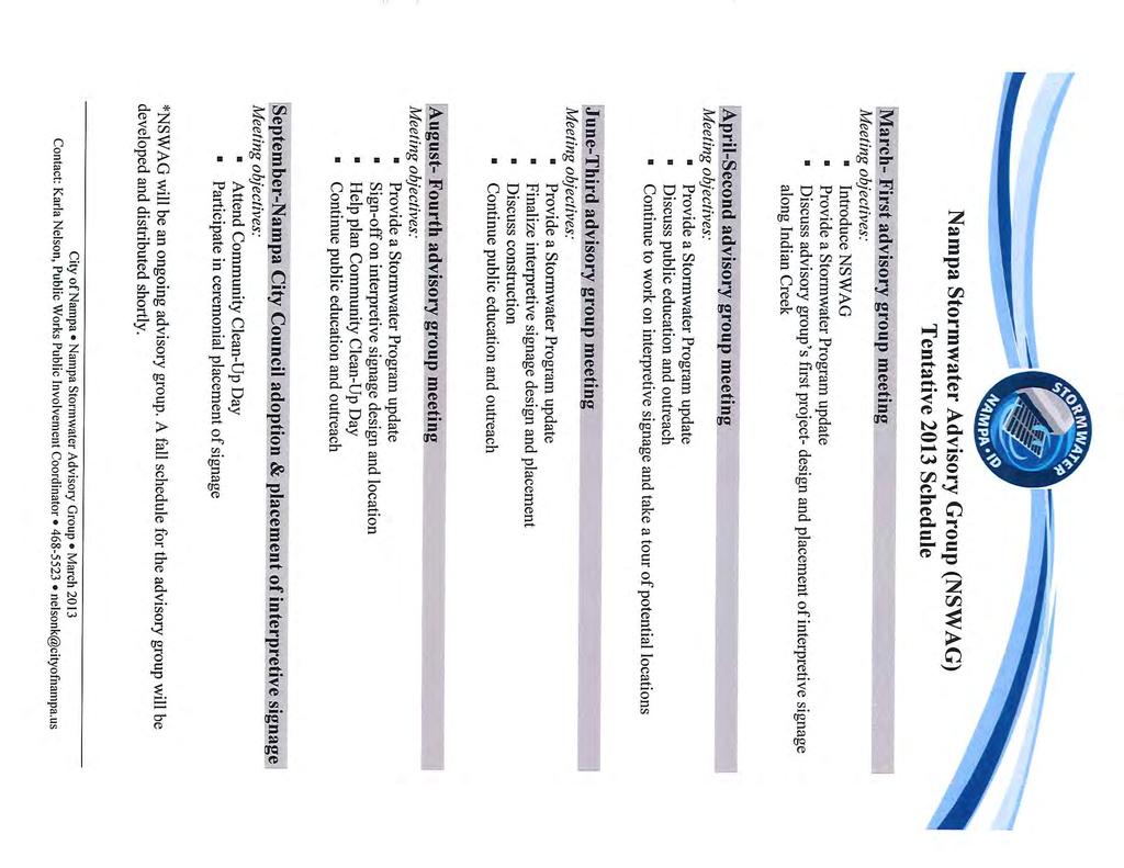
4 tormwater Interpretive ignage The City of Nampa has received grant money from the Environmental protection Agency to place bilingual interpretive signage along Indian Creek to educate the community about stormwater. The City has completed a preliminary survey of potential sites. The outcome of that survey is listed on the subsequent pages of this document. The sites are broken down into locations which could house interpretive signage in the short term and sites which could be developed for larger restoration/ environmental education purposes in the future. Many of the sites from this initial investigation correspond with improvements planned for in the North Nampa Indian Creek Trail Master Plan. North Nampa Indian Creek Trail Master Plan The North Nampa Indian Creek Trail Master Plan was developed in 2009 by the U Army Corps of Engineers and The City of Nampa. The plan calls for a continuous bicycle and pedestrian trail along Indian Creek from the existing trail at ugar treet and extends to the railroad at 1 st treet North and 7 th Avenue North. In addition to bicycle and pedestrian amenities the plan highlights areas for creek restoration, wetland rehabilitation, and open space that together will form a linear park. NWAG While the City has explored some potential sites for stormwater interpretive signage, others undoubtedly exist. Hopefully, NWAG members will help determine the location and content for the signs. tormwater Education ite urvey 10/29/12 1


5 tormwater Education ites hort Term 1. ite Benefits Indian Creek Park Indian Creek Park is the preferred location for a tormwater education/ community gathering place. This site has short and long term potential. The North Nampa Indian Creek Trail Master Plan describes site conditions which are conducive to tormwater Education. Indian Creek Trail will eventually go through the park, the fence separating the park from the creek will be removed, and a kiosk is planned at point 16 in the below map. The park is 2.29 acres ite Concerns Hispanic outreach target area Free lunch program location topping place along the future Indian Creek Trail City owned Maintained by the Parks Department Existing gathering place Fence separating the park from the creek Vegetation blocking the creek tormwater Education ite urvey 10/29/12 2


6 2. ite Benefits Indian Creek Trail (Peppermint Kings, Kings Amity) The existing Indian Creek Trail would be advantageous for interpretive signage related to stormwater education. Community members already bike and walk along this section of trail next to Indian Creek. Hispanic outreach target area City owned/ maintained ROW Existing trail Visual and physical access to Indian Creek ite Concerns Lacks large public space, limiting for gatherings and future stormwater installations 3. Dog Park The Nampa Dog Park is a beneficial location for tormwater education installations. The park is heavily frequented. Also encouraging dog owners to pick up after their pet is a goal of the tormwater program. ite Benefits Heavily frequented Targeted to dog owners Bisected by a drain City owned and maintained ite Concerns Not along the existing or future Indian Creek Trail Not adjacent to Indian Creek Not in Hispanic outreach target area tormwater Education ite urvey 10/29/12 3


7 4 tarr Park imilar to Indian Creek Park, tarr Park is also along Indian Creek and the future trail. However, the park is much smaller at.32 acres and is used less frequently. ite Benefits Hispanic outreach target area Adjacent to Indian Creek Adjacent to future trail City owned and maintained ite Concerns mall area,.32 acres Not as popular of a park Fence Vegetation along creek 5. City Acres Park City Acres Park is also along Indian Creek and the future trail. The park is 1.1 acres with an industrial neighbor. ite Benefits Hispanic outreach target area Adjacent to Indian Creek Adjacent to future trail City owned and maintained ite Concerns Industrial neighbor Not as popular of a park tormwater Education ite urvey 10/29/12 4


8 Long Term ites 1. Future Creek/ Wetland Restoration Area When Indian Creek Trail is complete the area marked by point 10 in the below map will be a restored wetland with some raised trails. Trail users will naturally be thinking about the water cycle and water quality at this location. Installing stormwater education interpretive signs would fit nicely in the environment. ite Benefits ite Concerns In the Hispanic outreach target area Adjacent to Indian Creek Trail Planned wetland/ creek restoration Highlighted in North Nampa Indian Creek Trail Master Plan Ownership Not suitable for installations beyond signage or benches Trail development timeline tormwater Education ite urvey 10/29/12 5


9 2. Creek Restoration Demonstration Project When Indian Creek Trail is complete the area marked by point 1 in the map below is planned to be a creek restoration demonstration project. However, the trail itself may remain on the opposite side of the creek. ite Benefits ite Concerns In the Hispanic outreach target area Adjacent to Indian Creek Trail Planned creek restoration area Highlighted in North Nampa Indian Creek Trail Master Plan Ownership, currently industrial development Access Trail development timeline tormwater Education ite urvey 10/29/12 6


10 3. Karcher Interchange Wetland The tate owns some unused land behind Winco. Access to the area is limited. At this point visitors to the site must drive on a dirt road and walk across train tracks. The general area is largely commercial with little connection to nature. ite Benefits tate owned Adjacent to Indian Creek Adjacent to future Indian Creek Trail Next to high vehicular traffic ite Concerns Access Commercial Area Not in Hispanic outreach target area Trail development timeline Loan or lease agreement needed with tate tormwater Education ite urvey 10/29/12 7


11 4. Karcher/ Middleton Intersection The Idaho Transportation Department and the City of Nampa are collaborating on a project to improve the Karcher/ Middleton Intersection. Project improvements require the City and ITD to purchase property on the southwest corner for drainage purposes and needed ROW. Part of the site could be used for a stormwater demonstration project. ite Benefits Adjacent to the Elijah Drain Adjacent to a future pathway Next to high vehicular traffic ite Concerns Not in Hispanic outreach area Not adjacent to Indian Creek tormwater Education ite urvey 10/29/12 8
12
13
14
15
16
17

18
19
20
21
22 Indian Creek Northside Madison Karcher Grimes Creek unset Oaks Park tormwater Education and Connectivity Concept for the North Nampa Indian Creek Trail McDonagh occer Park Grimes Drain Middle Lateral East Lateral Franklin Dewey Lateral Idaho Center North Drain Phyllis Canal tamm City Acres Park 11th Garrity Indian Creek tampede Park Caldwell Airport Davis Hunter Park Lakeview Park Creech Basketball Courts Yale 2nd 11th 3rd!!, tarr Park 7th Lone tar 11th 12th 3rd 16th 2nd!!, Indian Creek Park 3rd!P Indian Creek Victory Kings Mason Creek Happy Valley Roosevelt Roosevelt 7th 22nd East ide Park 24th Indian Creek!, North Nampa Lateral Kings Road Park Kings Road Grays Holly!,!,!,!, Lake Lowell Amity Maple heridan Bird Fern Colorado Diamond Chicago!, Dog Park Langdon Lateral!, Indian Creek Amity Elijah Drain outh Nampa Lateral Holly Aaron Drain Iowa Wilson Drain Liberty Park Nampa Recreation Center Potential Projects Powerline Rails To Trails outhside Happy Valley!,!!P Dooley 12th Ave Wilson Drain Educational ignage Outdoor Classroom Watershed Education Building Wetland/ Creek Restoration Waterways Wilson Creek Park 12th Ave Drain Herron Lateral unnyridge unnyridge kyview Park Existing Indian Creek Trail ± Future Indian Creek Trail Parks Wilson Drain Partridge Lateral Maplewood Park Greenhurst Miles Osborne Park Happy Valley

23 Mason Creek AV E 22 ND 2N D T TAR RD TAR RD N ROBINON RD N KING RD In kyview High chool ROBINON RD on La te East Valley Middle chool ra l RE 0 DR D ra i n 2 Our Watershed ROBINON BLVD Ridenbaugh Canal OUTHIDE BLVD H O E LOCUT LN POWERLINE RD LAK E E AMITY AVE DOOLEY LN W LOCUT LN T RD Creek k ee Cr E GREENHURT RD Am ity an gd di La n ek Ronald Reagan Elementary Lake Lowell OR Columbia High dia nc re Greenhurst Elementary Mount Calvary Cemetery Mason In UNNYRIDGE RD k Park Ridge Elementary E AMITY AVE HOLLY T outh Middle chool AIRP E VICTORY RD 2N D T 3R D T Eastside Park Cre e KING RD AV E Ma son AIRPORT RD N HOLLY T 12TH AVE RD CANYON CAN ADA RD N H 11 T N AV E 16 T H AV E 11 TH T 12 T H AV E 7T H Nampa Recreation Center MIDLAND BLVD T Elijah Drain Iowa City Park W GREENHURT RD 3R D Northwest Nazarene University Nampa High chool outh Fork Park Lakeview Park Indian Creek Park E ROOEVELT AVE LAKE LOWELL AVE Owyhee Elementary N AV E 7T H N CANYON T al T er CANYON T La t T A M M LN al West Park D LV GARRITY BLVD H T al N YALE T N CANYON T 2N D YB I 84 er wa rd s N FRANKLIN BLVD Ca n 11 T DAVI AVE Exit 38 IT RR GA AV E TEN LN llis I 84 t La Ed FD Roosevelt Elementary W IOWA AVE Kohlerlawn Cemetery H N TEDDY LN (Pvt) N MIDLAND BLVD Phyllis Canal N MIDDLETON RD Lincoln Park Ph y Exit 36 ey MIDWAY RD D ateral Duval L LV I 84 w De MIDDLETON RD W ROOEVELT AVE ek N UGAR T n LONE TAR RD LB Exit 35 E FRANKLIN RD Centennial/Ridgecrest Golf Course MITH AVE W EL Cr e THIDE BLVD NOR n Willow Elementary CA LD E KARCHER RD BU, West Campus Idaho Center N i ra ai Dr on ils W n ai in Dr Dra ah Jon Phyllis Canal W ORCHARD AVE A D on ils W FLAMINGO AVE an W KARCHER RD unset Oaks AVE YP RB h W ij a El di Optimist Park Birches Elementary BIRCH LN E CHERRY LN 11TH HE In W KARCHER RD W MCMILLAN RD Tenmile Creek IDAHO CENTER BLVD E CHERRY LN RC KA BU, Canyon Annex UTICK RD 11TH AVE N MADION RD W CHERRY LN 16 T Exit 33A N MI D LAN D BLVD 4 MO LN MIDWAY RD in Ninemile Creek Unna med 91 Ten mil l ec ree M k ille r Un La na te m ra ed l 13 4 NORTHIDE BLVD D ra Waterways era N FRANKLIN BLVD I8 m on Lateral N MIDDLETON RD D Floodway (AE) l Cana LV E HOMEDALE RD LAKE AVE Lat River N HAPPY VALLEY RD nch 500 yr (0.2% Annual Chance Flood Hazard) DEAN LN Br a Refuge is Phyll LB 92 PRECOTT LN e's W CHINDEN BLVD Island Unname d yr (1% Annual Flood (A, AE, AH, AO)) CHICAGO T N MIDDLETON RD N MIDLAND BLVD Gro v ± edlandmarks 93 Nampa Floodplain Lake Ext Fivemile Drain LINDEN RD Middle W EL o lo Lake ELM LN UTICK RD CA LD TAR RD Unname d ek ek LAKE AVE ek Cr e Cr e Unnamed92 HWY 20/26 Cr e al ter t La an nm ile Eas di ee Ma so n In Fif t on C reek AV E Mas am Lakes HAPPY VALLEY RD Nampa Waterways Un n Legend E LOCUT LN 3 4 Miles
FY Regional Transportation Improvement Program Basic Project List (All Values in Thousands of Dollars) All costs in current dollars
 All costs in current dollars") FY2016-2020 Regional Transportation Improvement Program Basic Project List () All costs in current dollars Project Name Key # Year Project Cost 10th Avenue Bridge, Caldwell 13055 2018 $1,367 10th Avenue
FY2016-2020 Regional Transportation Improvement Program Basic Project List () All costs in current dollars Project Name Key # Year Project Cost 10th Avenue Bridge, Caldwell 13055 2018 $1,367 10th Avenue
FY Transportation Improvement Program Basic Project List (in Thousands)
") FY2010-2014 Transportation Improvement Program Basic Project List (in Thousands) Project Name Key # Year Project Cost 16th Avenue North, 7th Street North to Garrity Boulevard GU09308 2011 $592 21st Avenue
FY2010-2014 Transportation Improvement Program Basic Project List (in Thousands) Project Name Key # Year Project Cost 16th Avenue North, 7th Street North to Garrity Boulevard GU09308 2011 $592 21st Avenue
FY Transportation Improvement Program Basic Project List (in Thousands) - Application Not Funded
 - Application Not Funded") FY2011-2015 Transportation Improvement Program Basic Project List (in Thousands) - Application Not Funded Requesting Agency: ACHD Project Name Key # Year Project Cost ACHD Thin Lift Overlay Projects 11922
FY2011-2015 Transportation Improvement Program Basic Project List (in Thousands) - Application Not Funded Requesting Agency: ACHD Project Name Key # Year Project Cost ACHD Thin Lift Overlay Projects 11922
±34 ACRES - LAKE AVENUE
 ±34 ACRES - LAE AVENUE EXCLUSIVE LISTING NAMPA, IDAHO PROPERTY OVERVIEW LOCATION Offering includes approximately 34 acres of beautiful country land located near Lake Lowell/Deerflat Wildlife Preserve and
±158 INDUSTRIAL ACRES
 ±158 INDUSTRIAL ACRES EXCLUSIVE LISTING WEST CALDWELL, IDAHO wy 30 LOCATION The Property is located north of Simplot Boulevard at the corner of Roedel Avenue and Riverside Street in West Caldwell, Idaho.
OR MISSION TRAIL ELEMENTARY
 Leawood: overview OVERLAD PARK 24: p.70 I-LA PARK 32: p.72 TOMAHAWK PARK 23: p.69 31: p.71 GEZER PARK OR MISSIO TRAIL ELEMETARY 22: p.68 W 133rd St W 135th St KASAS CITY MO - other segments Beginning/end
BACK COUNTRY UNIT PREFERRED ALTERNATIVE
 BACK COUNTRY UNIT PREFERRED ALTERNATIVE San Francisco (118 mi) Carmel-By-The-Sea Carmel River Carmel Valley Road State Beach Private Property Point Lobos State Reserve Point Lobos Ranch RUSTIC CAMPING
SHINGLE CREEK SECTION CONTENTS: BOHANON PARK CREEKVIEW PARK SHINGLE CREEK PARK SHINGLE CREEK REGIONAL TRAIL WEBBER PARK
 SHINGLE CREEK SECTION CONTENTS: BOHANON PARK CREEKVIEW PARK SHINGLE CREEK PARK SHINGLE CREEK REGIONAL TRAIL WEBBER PARK SPLASH PAD Good condition. PARK BUILDING BRYANT AVE N Good condition and unique to
Wilds. Headwaters. Lakes. Oxbows. Falls
 56 5 4 3 Wilds Headwaters Lakes Oxbows Falls 57 Zones It could be said the on-the-ground essence of this master plan appears within the next 6 pages of this report. As we learned in the preceding Cultural
NORTHWEST SECTION CONTENTS: CLEVELAND PARK FOLWELL PARK RYAN LAKE PARK VICTORY PRAIRIE DOG PARK VICTORY PARK
 NORTHWEST SECTION CONTENTS: CLEVELAND PARK FOLWELL PARK RYAN LAKE PARK VICTORY PRAIRIE DOG PARK VICTORY PARK LUCY LANEY COMMUNITY SCHOOL N 33RD AVE N 33RD AVE SINGLE-FAMILY RESIDENTIAL MULTI-USE DIAMOND
±2.47 ACRES AT THE VILLAGE AT MERIDIAN EXCLUSIVE LISTING MERIDIAN, ADA COUNTY, IDAHO
 ±2.47 ACRES AT THE VILLAGE AT MERIDIAN EXCLUSIVE LISTING MERIDIAN, ADA COUNTY, IDAHO CALL FOR OFFERS! Offers due Friday, September 8th at 2 PM. OFFERING Land Advisors Organization is pleased to present
Listing Summary. Land Listings. December Land with Trophy Bass Pond on Private Duck Hunting Preserve. Private Access. 20 Minutes from Caldwell.
 TBD E Canyon Loop Rd Adrian, OR West of Homedale on Hwy 19 to Oregon border, South on Canyon Loop Rd +/- 42.44 Acres Land with Trophy Bass Pond on Private Duck Hunting Preserve. Private Access. 20 Minutes
Auburn Trail / Ontario Pathways Trail Connector Feasibility Study Public Information Meeting Wednesday, August 22, 2012
 Auburn Trail / Ontario Pathways Trail Connector Feasibility Study Public Information Meeting Wednesday, August 22, 2012 Purpose of Feasibility Study Purpose Evaluate the feasibility of constructing a multiuse
3.1. West Union Community Plan Land Use Districts Index Map. Map 3.0. Be ndeme e r NW HELVETIA RD NW WEST UNION RD NW BROOKWOOD PKWY NW HUFFMAN ST
 Map 3.0 HELVETIA CENTURY BLVD CORNELIUS PASS Land Use Districts Index Map 3.1 WEST UNION J:\Workgroups\GISPlanning\Comp_Plan\CommunityPlans\CP_LUDmaps_Fig03_Index.mxd EVERGREEN BROOKWOOD PKWY HUFFMAN ST
Changes in TIP projects Draft vs. Final Draft
 Attachment 2 Dollars in $1,000 Key 08698 Franklin Road and Cloverdale Road Intersection Changes in TIP projects Draft vs. Final Draft RW - $1,314 UT - $1,000 CE - $341 CN - $3,675 CN - $499 09438 Caldwell
MEETING MINUTES District 1 Trail Planning Meeting 1
 MEETING MINUTES District 1 Trail Planning Meeting 1 June 1, 2017 2:00 PM 3:30 PM City of Two Harbors 2:00 Introductions Attendees: Lisa Austin, MnDOT Bryan Anderson, MnDOT Jasna Hadzic-Stanek, MnDOT Justin
$866,000. $1,400,000 Health Benefits $13,156,000 TOTAL ANNUAL DIRECT BENEFITS. $10,890,000 Economic Benefits
 SINGING RIVER TRAIL Trails Create Value + Generate Economic Activity Trails generate economic returns through improved health, safety, and environmental conditions, raise property values, and attract visitors.
Segment 2: La Crescent to Miller s Corner
 goal of the USFWS refuges is to conserve, protect and enhance fish, wildlife and plants and their habitats for the continuing benefit of the American people. Refuge lands are used largely for fishing,
IOWA ORNITHOLOGISTS' UNION - Birding Sites in Dallas County
 IOWA ORNITHOLOGISTS' UNION - Birding Sites in Dallas County Printed on 7/19/2018 Beaver Bottoms Wetland (restricted) (Important Bird Area) GPS Coordinates:, Ownership: Private (see directions for access)
SANDAG s Regional Transportation Plan
 SANDAG s Regional Transportation Plan Oceanside 5 Camp Pendleton Carlsbad P A C C I I F I C C O O C C E E A A N N 472 398 76 Encinitas 399 78 Solana Beach 472 Vista 15 San Marcos 399 399 470 610 Escondido
Abbott Rd Rehabilitation Phase II - Elmore Rd to Birch Rd
 Abbott Rd Rehabilitation Phase II - Elmore Rd to Birch Rd Project ID SOA07003 Department State of Alaska Project Type Improvement Start Date December 2017 Location Assembly: Section 4, Seats F & G, Assembly:
RIDGEFIELD PARKS February 2016
 RIDGEFIELD PARKS February 2016 Hayden Park Neighborhood Park Amenities Sign with Name of Park and City of Ridgefield Logo Lamp Post Parking Area Play Set Swings Sign with Playground Rules Durable Benches
A CASE FOR COMPLETING THE JORDAN RIVER PARKWAY: A
 A CASE FOR COMPLETING THE JORDAN RIVER PARKWAY: A safe crossing at 9000 South and 850 West Proposed 9000 South Underpass Parkway Timeline Parkway, Trail, and Tourism Facts Blueprint Jordan River 1971 1973
HUTTO PFLUGERVILLE Y 183. Leander Rehabilitation PUD Northwest. Park at Lakeline. Lakeline Mall. Texas Guaranteed. Student Loan Corp.
 BRIARCLIFF JONESTOWN POINT VENTURE LAKEWAY SUBJECT VOLENTE CEDAR PARK PFLUGERVILLE HUTTO TAYLOR ELGIN 9.3 Acres 3.8 Acres M E TRL B ULLI CK C REEK RD HOLL O W RD Comanche Canyon ETJ PUD Twin Creeks Country
Listing Summary. Land Listings. April Land with Trophy Bass Pond on Private Duck Hunting Preserve. Private Access. 20 Minutes from Caldwell.
 TBD E Canyon Loop Rd Adrian, OR West of Homedale on Hwy 19 to Oregon border, South on Canyon Loop Rd +/- 42.44 Acres Land with Trophy Bass Pond on Private Duck Hunting Preserve. Private Access. 20 Minutes
DRAFT TH AVE NE URBAN DESIGN MERIT PRESENTATION DPD# NOVEMBER 2017
 DRAFT 11.08.17 4801 24TH AVE NE URBAN DESIGN MERIT PRESENTATION 17-002 DPD#3027312 16 NOVEMBER 2017 PROJECT BACKGROUND URBAN DESIGN ANALYSIS VACATION / NO-VACATION COMPARISON URBAN DESIGN MERIT INTRODUCTION
Completion: August 2011 LS #321 Design LS #8
 1 CIPNumber c350406 2 c350302 3 c350902 LEGEND PERMITTING/ BIDDING CHARLOTTE COUNTY UTILITIES Burnt Store Water Reclamation Facility (Expansion to 0.75 MGD) East Port Expansion Water Reclamation Facility
Broker Information. Address 2000 Fuller Road, West Des Moines, IA Office North Pointe Land For Sale Grimes, IA
 Broker Information LOCATION LAND SIZE 18.6 Acres 810,216 +/- sf SALES PRICE $1,580,000.00 or $1.95 psf ZONING C2 General and Highway Service Commercial Heritage at Grimes Light Coming 2016 North Pointe
Northeast Quadrant Distinctive Features
 NORTHEAST QUADRANT Northeast Quadrant Distinctive Features LAND USE The Northeast Quadrant includes all the area within the planning area that is east of Interstate 5 and to the north of State Route 44.
BASSETTS CREEK SECTION CONTENTS: BASSETTS CREEK BRYN MAWR LUCE LINE
 BASSETTS CREEK SECTION CONTENTS: BASSETTS CREEK BRYN MAWR LUCE LINE GLENWOOD AVE MULTI-USE DIAMONDS VINCENT AVE N MORGAN AVE N PENN AVE N DOG PARK MULTI-USE FIELDS PLAYGROUND AK E RD S CHESTNUT AVE DA
FEASIBILITY CRITERIA
 This chapter describes the methodology and criteria used to evaluate the feasibility of developing trails throughout the study areas. Land availability, habitat sensitivity, roadway crossings and on-street
Wichita Falls MPO - MTP Project List 1 of 6
 Wichita Falls MPO - MTP Project List 1 of 6 FUNDING SCHEDULE FOR WICHITA FALLS MPO 2015-2040 M TxDOT Ten-Year Plan 2016-2026 TxDOT STATE, PROJECTS (TABLE I) ESTIMATED STATUS HIGHWAY CSJ PROJECT LIMITS
Flood History. Floodplain Descriptions
 Flood History The worst flooding in the area took place in 1966, 1969, 1971, 1995 and 1998. The storms in 1966 and 1969 caused considerable damage throughout the area due to flooding, erosion and debris
Citrus Heights Creek Corridor Trail Project Trail Advisory Group Field Trip #2 September 11, :00 11:00 am Trellis Hall, Citrus Heights
 September 11, 2013 9:00 11:00 am Trellis Hall, Citrus Heights Project Overview The City of Citrus Heights is studying the feasibility of establishing a multi use trail system within the City s 26 miles
IOWA ORNITHOLOGISTS' UNION - Birding Sites in Linn County
 IOWA ORNITHOLOGISTS' UNION - Birding Sites in Linn County Printed on 6/15/2018 Bever Park (ebird Hotspot) GPS Coordinates: 41.9851219,-91.6269125 Restrooms Parking Trails ADA Accessible Trails Boyson Trail
Southwest Quadrant Distinctive Features
 SOUTHWEST QUADRANT Southwest Quadrant Distinctive Features LAND USE The 31.17 square mile Southwest Quadrant includes all the area within the planning area west of I-5 and south of the Sacramento River.
Ridgefield Crossing. Mixed-Use Development. Pricing: Site. Possible build-to-suit FOR SALE, GROUND LEASE, OR BUILT-TO-SUIT
 N 65th Ave N 10th St Pioneer St Site S 5th St S 6th Way Mixed-Use Development New mixed-use development with great freeway access. 128 housing units and 11 commercial lots planned. Drive-thru & build-to-suit
City of Sierra Madre STUDY AREA PROFILE
 City of Madre STUDY AREA PROFILE STUDY AREA ID #112 BASE MAP PARK METRICS WHERE ARE PARKS MOST NEEDED AMENITY QUANTITIES AND CONDITIONS PARK NEEDS FRAMEWORK PROJECT COST ESTIMATES PROJECT REPORTING FORM
Blue River Trail Master Plan JSA to Town Hall June 2004
 Blue River Trail Master Plan JSA to Town Hall June 2004 Prepared for: Silverthorne Town Council Silverthorne SPORT Committee Department of Recreation and Culture Silverthorne Public Works Silverthorne
ANCLOTE COASTAL TRAIL ALTERNATIVES ANALYSIS STUDY
 ANCLOTE COASTAL TRAIL ALTERNATIVES ANALYSIS STUDY PASCO COUNTY MPO JULY 2015 PROJECT OVERVIEW... INTRODUCTION EXECUTIVE SUMMARY CONTEXT... TAMPA BAY AREA, PINELLAS, & PASCO COUNTY S MULTI-USE TRAIL PLANS
City of Solvang SUNNY FIELDS SPUR TRAIL STUDY
 City of Solvang SUNNY FIELDS SPUR TRAIL STUDY project description The City of Solvang, in partnership with the County of Santa Barbara Public Works Department, is developing an alignment study for a proposed
China Creek North Park Upgrades and Glen Pump Station. Park Board Committee Meeting Monday, July 10, 2017
 China Creek North Park Upgrades and Glen Pump Station Park Board Committee Meeting Monday, July 10, 2017 Purpose The purpose of this presentation is to: Share the results of the public engagement processes;
STORY MILL COMMUNITY PARK
 OWNER: City of Bozeman Department or Parks and Recreation P.O. Box 1230, 415 N. Bozeman Street Bozeman, MT 59715 Tel: (406)-582-2908 APPLICANT: The Trust for Public Land 1007 E. Main Street, Suite 300
MORGAN CREEK GREENWAY Final Report APPENDICES
 APPENDICES MORGAN CREEK GREENWAY Appendix A Photos of Existing Conditions in Trail Corridor Photos of existing conditions Main trail corridor - February 2009 Photos of existing conditions south bank Morgan
Airport Planning Area
 PLANNING AREA POLICIES l AIRPORT Airport Planning Area LOCATION AND CONTEXT The Airport Planning Area ( Airport area ) is a key part of Boise s economy and transportation network; it features a multi-purpose
Lakeview Fifteen. Round Trip Mileage: 0.8 miles. Time Estimate: 16 minutes
 Lakeview Fifteen Head southwest toward Garland St. (115 ft) Turn right onto Garland St. E (0.2 mi) Head west on Garland St. E toward Neshonoc Rd. (453 ft) Turn right onto Neshonoc Rd towards Ray PI (0.1
CONTEXT MAP COMPREHENSIVE RECREATIONAL MASTER PLAN. to Virginia Civil War Trails. Riverside Park. Mountains to Sea Trail. Rowe Environmental Park
 OMPREHENSIE REREATIONAL MASTER PLAN ONTEXT MAP to irginia ivil War Trails NOT TO SALE iver tr rara A Riverside Mountains to Sea Trail Rowe Environmental School The Ararat River reenway is located along
Assessing Your Trails, Keeping Them Safe and Enjoyable
 Jon Wood, PLA, ASLA Associate Vice President Stewart Bert Lynn, PLA, ASLA, LEED AP Project Manager Mecklenburg County Asset and Facility Management Assessing Your Trails, Keeping Them Safe and Enjoyable
IOWA ORNITHOLOGISTS' UNION - Birding Sites in Cerro Gordo County
 IOWA ORNITHOLOGISTS' UNION - Birding Sites in Cerro Gordo County Printed on 11/17/2018 Blue-wing Marsh GPS Coordinates: 43.0834956379463,-93.4430980682373 Pure natural area primarily used for hunting.
S i t e A n a ly s i s
 S i t e A n a ly s i s 11 SECTION B SITE ANALYSIS Existing Conditions TRANSPORTATION CONTEXT: The Ohlone Greenway site, paralleling San Pablo Avenue to the west, is centrally located within the City of
U.S. Army Corps of Engineers Fiscal Year 2013 Handshake Program Application
 U.S. Army Corps of Engineers Fiscal Year 2013 Handshake Program Application Please review instructions before completing application! Corps Lake/Project Name:Rathbun Lake/ North Shore Trail Handshake Proposal
Section II. Planning & Public Process Planning for the Baker/Carver Regional Trail began in 2010 as a City of Minnetrista initiative.
 Section II Planning & Public Process Planning for the began in 2010 as a City of initiative. city staff began discussions with the Park District on the possibility of a north/south regional trail connection
Dungeness Recreation Area County Park Master Plan
 Dungeness Recreation Area County Park Public Outreach Meeting October 10, 2007 Project Overview USFWS Site Dungeness Recreation Area County Park Meeting Objectives: Re-Introduce project; provide status
BURLINGTON POLICE DEPARTMENT Daily Activity Log
 BURLINGTON POLICE DEPARTMENT Daily Activity Log 01/08/2019 thru 01/10/2019 Selected Agency Type: Police Selected Agency ID: All 19-000756 01/08/2019 00:16:09 21589 DMC HWY 79 HARMONY BIBLE CHURCH (1) 19-000757
INGHAM COUNTY TRAILS AND PARKS TASK FORCE MEETING 2
 INGHAM COUNTY TRAILS AND PARKS TASK FORCE MEETING 2 October 22, 2015 Mannik and Smith Group Michigan Trails & Greenways Alliance AGENDA FOR TONIGHT 1. Project Approach, Process and Timeframe 2. Public
Town of Limon Comprehensive Plan CHAPTER 6 TOURISM AND THE VISITOR ECONOMY
 CHAPTER 6 TOURISM AND THE VISITOR ECONOMY 65 VISION Limon s location at the intersection of Interstate 70, and Highways 24, 40, 71, and 287, provides steady traveler traffic with an estimated 80,000 overnight
Macleod Trail Corridor Study. Welcome. Macleod Trail Corridor Study Open House. Presentation of Proposed Design Concepts
 Macleod Trail Corridor Study Welcome Macleod Trail Corridor Study Open House Presentation of Proposed Design Concepts Study Purpose Develop a corridor plan for Macleod Trail that aligns with The City s:
Bear Creek Habitat Improvement Project
 06/10/10 Bear Creek Habitat Improvement Project El Paso County, Colorado Pike National Forest and Colorado Springs Utilities Owned Land Report prepared by: Eric Billmeyer Executive Director Rocky Mountain
Raytown: overview. map. Santa Fe, Oregon, and California National Historic Trails KANSAS CITY KANSAS CITY. 38 Trail alignments: Raytown.
 Raytown: overview Blue Ridge Cut-off map 18: p.42 RICE- TREMOTI HOME Raytown Tfwy KASAS 17: p.41 JUCTIO WITH ROCK ISLAD LIE RIGHT OF WAY 16: p.40 BUS STOP AT E 51ST AD BLUE RIDGE (KASAS ) Sterling Ave
Design Charrette Public Meeting
 Design Charrette Public Meeting Citizen Advisory Committee Members of the Public November 2, 2011 - Theodore Wirth Chalet - 6:30-8:30 p.m. Park Background: Visitation Estimation 2010 Regional Visitation
Public Workshop #1 Results Report. October 31, 2017
 Public Workshop # Results Report October 3, 07 Table of Contents Section : Introduction... 3 Section : Comment Card Responses... 4 Section 3: Additional Comments... 3 Section 4: Full Comment Summary...
Available Freestanding Buildings
 PROPERTY FEATURES Nine (9) Planned, Freestanding Dock Loading Fenced Yard Possible Abundant Vehicle Parking Generous Column Spacing Fire Sprinklers Skylights Build to Suit Office LED Lighting 480 Volt
Header i
 Header i 048285014.10 Header Sub Title Body Text here. Body text here. Body text here. Section 1... 1 Executive Summary... 1 Opportunities and Constraints... 3 Overall Opportunities and Constraints Map
Birmingham City Centre Vision for Movement
 Birmingham City Centre Vision for Movement Wes Sedman - Centro Commissioning Team Laying the foundations for a vibrant and liveable global city Birmingham Big City Plan - A City Centre Masterplan A vision
Ralph C. Wilson, Jr. Centennial Park Ralph C. Wilson, Jr. Foundation University at Buffalo Regional Institute 17 January 2019
 Ralph C. Wilson, Jr. Centennial Park Ralph C. Wilson, Jr. Foundation University at Buffalo Regional Institute 17 January 2019 Michael Van Valkenburgh Associates Inc. Who is MVVA? Brooklyn Bridge Park,
NORTH OF BROADWAY SECTION CONTENTS: COTTAGE PARK FARVIEW PARK GLEN GALE PARK IRVING TRIANGLE JORDAN PARK NEWTON PARK PERKINS HILL PARK
 NORTH OF BROADWAY SECTION CONTENTS: COTTAGE PARK FARVIEW PARK GLEN GALE PARK IRVING TRIANGLE JORDAN PARK NEWTON PARK PERKINS HILL PARK N ILIO NA VE N JAM ES AV E PLAYGROUND PAR K PRO PER TY B OUN DAR Y
MPRB: Southwest LRT Community Advisory Committee Issues and Outcomes by Location Current to: 12 November 2010
 MPRB: Southwest LRT Community Advisory Committee Issues and Outcomes by Location Current to: 12 November 2010 This is a compilation of issues and outcomes identified by the CAC. It is a work in progress,
Chapter eight. Parks and Recreation. Introduction. Crystal Lake Park District
 Chapter eight Parks and Recreation Introduction One of the indicators of quality of life in a city is the parks and recreation system. The City of Crystal Lake is fortunate to have an excellent parks and
4.19 Parks, Recreation, and Conservation Lands
 interchange would have on the Reed Paige Clark Homestead located on the north side of Stonehenge Road. Alternative D would also affect Palmer Homestead, E.F. Adams House, and Knapp Brothers Shoe Manufacturing
APPENDIX F List of Commitments
 APPENDIX F List of Commitments s Table F.1 Standard Mitigation Measures Mitigation Measure MnDOT Specification Number Status Update Description Status Update Utilities Provide early notice to utility operators
City Council Workshop July 26, 2010
 Des Moines Trails Connecting a Community City Council Workshop July 26, 2010 1 OVERVIEW Trail Benefits Trails Progress How We Fund Trails What s Next for Trails 2 What is a trail? Paved Trails 10 wide
CEDAR FALLS POLICE DEPARTMENT Call Reporting Press Report
 CEDAR FALLS POLICE DEPARTMENT Call Reporting Press Report 6/26/2018 7:00:00AM thru 6/28/2018 7:00:00AM Selected Agency Type: Police Selected Agency ID: CFPD Incident Date & Time Reported Location / Reporting
The latest Multi-Tenant Research Park in the Bay Area accommodating users from 10,000 SF to 600,000 SF
 I N N O V A T I O N S T A R T S H E R E The latest Multi-Tenant Research Park in the Bay Area accommodating users from 10,000 SF to 600,000 SF Building SF 1 7333 Gateway Blvd Fully Leased 2 7555 Gateway
8,844 SF office micro-campus for sale or lease
 8,844 SF office micro-campus for sale or lease Escondido, CA 92025 MARC POSTHUMUS Vice President +1 760 930 7950 marc.posthumus@colliers.com CHRIS WILLIAMS Associate Vice President +1 760 930 7952 chris.williams@colliers.com
Projects Awarded GOCO Funding in Mesa County
 Grant Type Fiscal Year Open Space 2016 Project Sponsor Project Title Grant Amount Rocky Mountain Elk Foundation Bull Creek Conservation Easement Acres Conserved $269,500.00 523.89 Open Space 2016 Mesa
The Baker/Carver Regional Trail is intended to
 Section V Design Guidance The Baker/Carver Regional Trail is intended to safely accommodate 183,000 annual visits, an array of non-motorized uses, a variety of skill levels, and persons with special needs.
PARKS AND RECREATION TECHNICAL MEMORANDUM
 PARKS AND RECREATION TECHNICAL MEMORANDUM 1. INTRODUCTION 1.1 Project Description The Virginia Department of Transportation (VDOT), in cooperation with the Federal Highway Administration (FHWA), is considering
Introduction. Project Overview
 Washington Blvd./Andora Widening Project Community Open House & Public Scoping Meeting Summary Wednesday, September 21, 2016 6:00 7:30 p.m. Vencil Brown Elementary School, Roseville Introduction On Wednesday,
Welcome to the Illinois High-Speed Rail Chicago to St. Louis Construction Update Meeting. Today s meeting will provide an overview of the Program,
 Welcome to the Illinois High-Speed Rail Chicago to St. Louis Construction Update Meeting. Today s meeting will provide an overview of the Program, updates on construction to be held in this area, and how
Welcome to Dayton Parkway Interchange Open House. November 26, 2018
 Welcome to Dayton Parkway Interchange Open House November 26, 2018 Project Partners Minnesota DOT Hennepin County City of Rogers Dayton Project History NW Hennepin County I94 Study 2007/08 Interchange
Gulf State Park. Enhancement Project Update December Gulf State Park Project - Dec 2016 Update. i
 Gulf State Park Enhancement Project Update December 01 Gulf State Park Project - Dec 01 Update. i Gulf State Park will be an international benchmark for environmental and economic sustainability demonstrating
Meshach Browning Trail System at the Deep Creek Lake Lion s Club Park on Bumble Bee Rd.
 Meshach Browning Trail System at the Deep Creek Lake Lion s Club Park on Bumble Bee Rd. The Meshach Browning trail system will be a public, non-motorized, multi-use (running, dog-walking, cross country
Trails, steps, & P-Patch to be south of I- 5 Colonnade
 UW Campus Trails, steps, & P-Patch to be south of I- 5 Colonnade Blaine and Howe Street steps REI N new lighting existing features connector trail new features or improvements overhead freeway and support
SAN ANTONIO RIVER IMPROVEMENTS PROJECT. April 27, 2009
 SAN ANTONIO RIVER IMPROVEMENTS PROJECT April 27, 2009 1 Project Limits 2 Project Partners City of San Antonio Provides project funding for project amenities (i.e.. Sidewalks, Landscaping, Lighting, etc.)
RIVER ACCESS STRATEGY
 RIVER ACCESS STRATEGY The River Access Strategy is a 10-year plan the City of Edmonton is developing to inform future programming, operations and infrastructure improvements that support access to the
1133 W. MORSE BLVD, WINTER PARK, FL OFFICE / MEDICAL SPACE FOR LEASE
 1133 W. MORSE BLVD, WINTER PARK, FL 32789 OFFICE / MEDICAL SPACE FOR LEASE PROPERTY OVERVIEW OFFICE / MEDICAL BUILDING IN GREAT WINTER PARK LOCATION UP TO 11,361± SF (ENTIRE BUILDING) AVAILABLE FIRST &
Classifications, Inventory and Level of Service
 Classifications, Inventory and Level of Service Section 3 Kenmore Park, Recreation and Open Space Plan 1 P a g e Classifications and Inventory Park Classifications Kenmore classifies its parks based upon
SAN ANTONIO RIVER IMPROVEMENTS PROJECT. August 6, 2008
 SAN ANTONIO RIVER IMPROVEMENTS PROJECT August 6, 2008 1 History of the SA River Improvements 1921 Flood Olmos Dam Complete in 1929 Downtown Flood Relief Projects in 1950 s Dams on the River Channel and
2. STAKEHOLDER FEEDBACK // What We Heard
 1. QUARRY ROAD TRAIL // Welcome to the Information Session PROJECT DESCRIPTION WHY WE ARE HERE Quarry Road Trail is a popular commuter trail and recreational area for Calgarians. 1. To report citizen feedback
2018 Capital Improvement Budget Department Summary by Funding Source
 Department Summary by Funding Source Department Bonds State Federal Other Total Fire 3,470 - - 290 3,760 Health & Human Services 217 - - 75 292 Information Technology - - - 5,937 5,937 Library 590 - -
City of Walnut STUDY AREA PROFILE
 City of Walnut STUDY AREA PROFILE STUDY AREA ID #133 BASE MAP PARK METRICS WHERE ARE PARKS MOST NEEDED AMENITY QUANTITIES AND CONDITIONS PARK NEEDS FRAMEWORK PROJECT COST ESTIMATES PROJECT REPORTING FORM
INTER-OFFICE MEMORANDUM
 INTER-OFFICE MEMORANDUM TO: FROM: Development Review Committee John G. Thomson, AICP./(' Land Development Manager,... j \ DATE: February 10, 2014 SUBJECT: DRC Meeting Date: February 18, 2014 Request for
COPPER HERITAGE TRAIL CONCEPTUAL PLAN 2011
 COPPER HERITAGE TRAIL CONCEPTUAL PLAN 2011 A Proposed 40 Mile Non-Motorized Rail Trail Route Connecting The Historic Communities Of the Copper Country Prepared For: Western Upper Peninsula Health Department
South Central Division and Patrol Realignment
 South Central Division and Patrol Realignment New Facility & Service Model August 7, 2006 Public Safety Committee Dallas Police Department 1999 East Camp Wisdom Rd. (West of Intersection of Lancaster Rd.)
SECTION 3 GENERAL DESCRIPTION OF THE RIVER BASIN
 SECTION 3 GENERAL DESCRIPTION OF THE RIVER BASIN SECTION 3 GENERAL DESCRIPTION OF THE RIVER BASIN River basin description. A general description of the river basin or subbasin, as appropriate, in which
Community Input Meeting. Fairgrounds Master Planning Update. January 7, 2016, 7 pm
 Community Input Meeting Fairgrounds Master Planning Update January 7, 2016, 7 pm Fiesta Hall Santa Clara County Fairgrounds 355 Tully Road, San Jose, CA Tonight s Agenda 1) Board of Supervisors Direction
2009 Regional Solicitation Selected Projects*
 2009 Regional Solicitation Selected Projects* Special Federal Allocation from the MPO Mn/DOT I-494/TH169 Interchange Reconstruction $34,000,000 Surface Transportation Program - Urban Guarantee AR-09-10
City of Haslett. City of East Lansing. City of East Lansing
 Central Park North (Nancy L. Moore Park) Lake Park North Expansion White Park Expansion #2 White Park Expansion #1 County East East Haslett East East TF87-212 Acquisition $90,000.00 Park. TF08-138 Acquisition
Independence: overview
 : overview Kentucky Ave 8: p.30 SUGAR CREEK SATA FE. OREGO, CALIFORIA 7: p.29 6: p.28 9: p.31 10: p.32 Square, Jackson County Courthouse. Photo: Vireo Trail swale area, Santa Fe Trail. Photo: Vireo HISTORIC
Attachment D: PHOTO LOG CITY OF ARCATA RAIL-WITH-TRAIL CONNECTIVITY PROJECT
 01051-09004 Attachment D: PHOTO LOG CITY OF ARCATA RAIL-WITH-TRAIL CONNECTIVITY PROJECT DRAFT: June 30, 2010 Applicant: City of Arcata 736 F Street Arcata, CA 95521 Phone (707) 825-2154 Prepared by: Winzler