The Story of Craigellachie National Nature Reserve
|
|
|
- Lora Singleton
- 5 years ago
- Views:
Transcription


1 Foreword The Story of Craigellachie National Nature Reserve Craigellachie National Nature Reserve (NNR) stands proud to the west of the A9 by Aviemore, in Strathspey. The Reserve offers a tranquil respite, for local people and visitors alike, from the hustle and bustle of the nearby village. It is one of a suite of nine 1 NNRs within the Cairngorms National Park. Craigellachie is noted for one of the largest remaining birch woodlands in Strathspey, but this is not its only strength. A network of trails meander gently amongst the birch and around the lochs, which on summer days host scintillating dragonfly displays. In marked contrast to the nearby pinewoods, the birch of Craigellachie mirrors the mood of the season. At the first hint of spring warmth the birch tree, affectionately called the Lady of the Woods, adorns her monochrome winter mantle with the verdant, vibrant green of fresh new leaves, while at her feet spring clusters of wood anemone and dog violet. As the woodland path ascends toward the viewpoint, natural breaks in the birch canopy offer tantalising glimpses of a panorama that gradually unfurls, to reveal a magnificent overview of the Cairngorm plateau encompassing much of the western part of the Cairngorms National Park and Strath Spey. The imposing crag, Creag Eileachaidh for which the Reserve is named, was once a traditional vantage point for Clan Grant, and still provides security for the resident breeding peregrines. Visitors may be rewarded with a spectacular aerial display if they are lucky enough to see the falcons on the wing. Craigellachie is one of more than 45 NNRs in Scotland. Scotland s NNRs are special places for nature, where some of the best examples of Scotland s wildlife are managed. Every Reserve is carefully managed both for nature and for people, giving visitors the opportunity to experience our rich natural heritage. 1 The nine Cairngorms NNRs include: Abernethy NNR, Corrie Fee NNR, Creag Meagaidh NNR (just outwith the Park), Craigellachie NNR, Glen Tanar NNR, Glenmore NNR, Insh Marshes NNR, Invereshie & Inshriach NNR and Muir of Dinnet NNR.

2 The Story of Craigellachie National Nature Reserve contains background information about the Reserve, describing the wildlife interest, its land use history and management since it became a Reserve. How we intend to manage the Reserve in future years is outlined in the Reserve Proposals. We invite your comments on these Proposals and your feedback informs the production of the final Reserve Plan, which is the blueprint for management of the Reserve for the next few years. For further information about Craigellachie National Nature Reserve please contact: Scottish Natural Heritage, Achantoul, Aviemore, Inverness-shire, PH22 1QD. Telephone: Fax: southhighland@snh.gov.uk ii
3 Contents Foreword i Contents iii Maps of Craigellachie NNR iv 1 Introduction to Craigellachie NNR 1 2 The Natural Heritage of Craigellachie NNR 4 3 Management before the land became Craigellachie NNR 8 4 Management of Craigellachie NNR 9 5 Document properties 15 iii


4 Maps of Craigellachie NNR Location Map Boundaries of Craigellachie NNR iv


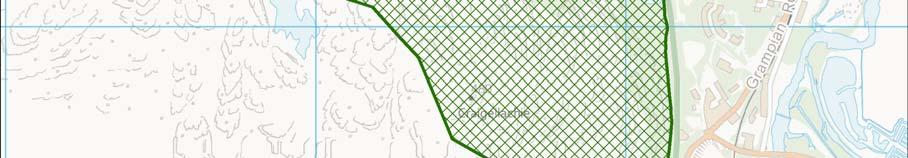
5 Map showing key locations at Craigellachie NNR v

 just above the A9 to 535m at Creag na h-iolaire on the western boundary.")
6 1 Introduction to Craigellachie NNR Craigellachie NNR is on the western edge of the village of Aviemore in the Central Highlands of Scotland, some 53 kilometres (km) south of Inverness. The Reserve occupies the east facing, lower slopes of the Monadhliath Mountains overlooking the River Spey. It stretches for 2km northwards on the western side of the A9 opposite Aviemore and covers an area of 257 hectares (ha). The Reserve rises from an altitude of 225 metres (m) just above the A9 to 535m at Creag na h-iolaire on the western boundary. To the north it is bounded by the Caledonian pinewoods and grouse moors of the Reidhaven Estate which is part of the Seafield Estate, and to the south by the grouse moors and deer forest of Kinrara Estate. Like much of the Cairngorms, the rock types on the Reserve are mainly metamorphosed gneisses and schists with extensive granite intrusions. The rocks are all acidic, resistant to weathering and erosion and the overlying soils being acidic are poor in nutrients. The Cairngorms are relatively shielded from the westerly maritime air flow by the western mountain ranges, and experience a more continental climate. This is characterised by more severe winters and relatively low rainfall. Average monthly temperatures range from 5 C in December to 19 C in July, with a lower and upper range of minus 25 C and plus 31 C. The east facing aspect of the Reserve means that for most of the year the Reserve lies in deep shade. The climate, aspect and soil conditions all influence the habitats found on the Reserve which are incredibly varied for such a small area. The Reserve is dominated by the birch woodland which extends up to 370m and clings on to the south and east facing crags and slopes. On the higher ground dry and wet heaths and blanket bogs have developed which together with three lochans add to the diversity of the habitats found on the Reserve. The variety of habitats provides a home for a correspondingly diverse View over Craigellachie NNR to Aviemore 1
7 range of species. Craigellachie supports a rich diversity of northern moths which include the nationally scarce Kentish glory. Peregrine falcon breed on the crags and the trees and rocks support a variety of lichens and mosses. Craigellachie features prominently in local culture and the Clan Grant symbology. The clan arms show an image of a burning hill which is Craig Elachie - the rallying point for the clan. The summit of the crags was the site of signal fires to bring clan members together. The clan slogan is Stand fast Caig Elachie! Craigellachie was first declared an NNR in The Reserve is owned by Reidhaven Estate and managed by Scottish Natural Heritage (SNH) through a lease. Craigellachie has been designated for its wildlife interest at a UK level. It forms part of the larger Craigellachie Site of Special Scientific Interest (SSSI) and is nationally important for the upland birch woodland and its moth assemblage. The Reserve is one of a suite of NNRs that lie within the Cairngorms National Park and also falls within the Cairngorms National Scenic Area (NSA). Further information on these designations can be found via the links at the end of this document. Table 1: Designated features & species of interest for Craigellachie NNR Designation Site of Special Species Scientific Interest Site name Craigellachie UK BAP RDB Special visitor interest Habitat Upland birch woodland Species Moth assemblage: Kentish glory 1 Rannoch sprawler 1 Angle striped sallow 1 Scarce prominent 1 Great brocade 1 Cousin German 1 Pearl-bordered Fritillary 2
8 Designation Site of Special Species Scientific Interest Site name Craigellachie UK BAP RDB Special visitor interest Peregrine Tree pipit Lesser redpoll Common cuckoo Spotted flycatcher Wood warbler Bullfinch Song thrush Ring ouzel Scottish crossbill Black grouse Red grouse Juniper UK BAP UK Biodiversity Action Plan; RDB Red Data Book; 1 species identified as part of the moth assemblage 3
, and changed by heat and pressure to metamorphic rocks during the Caledonian orogeny (435 500 million years")
9 2 The Natural Heritage of Craigellachie NNR Geology There are two main rock types present on the Reserve: gneisses and schists. These were deposited as muds and sands in Precambrian times (600 million years ago or more), and changed by heat and pressure to metamorphic rocks during the Caledonian orogeny ( million years ago). The highest ground on the Reserve is granite which was intruded into the surrounding rock million years ago. Habitats Woodland Craigellachie is one of the largest semi-natural upland birch woods in Strathspey and is important for the diversity of its animals and plants found in north east Scotland. Birch was one of the first broad-leafed trees to appear after the ice Upland birch woodland retreated, about 10,000 years ago. Craigellachie s woodland is typical of many Highland birchwoods, occupying a steep valley side where brown earth soils have developed on shallow, rocky material derived from glacial deposits and acid bedrock. Craigellachie has a history of non-intervention and is an example of a long-established woodland of semi-natural origin, having arisen before Many of the trees on the Reserve are about 100 years old, exhibiting a uniform age structure with large stands of mature, even-aged trees with an open canopy. The birch woods consist almost entirely of silver birch which tends to be associated with the drier soils and some downy birch, a tree of poorly drained and frequently peaty sites. Other broadleaves also occur on the Reserve including aspen, rowan, hazel, bird cherry, eared and grey willows. Scots pine and juniper are also scattered across the Reserve. 4

10 Open habitats Throughout the woodland and out onto the hill top there is a good mix of small but locally important open habitats. On the hill top these include areas of dry heath with bearberry, wet heath and blanket bog. Within the woodland there are open glades, wet flushes and running and standing freshwater habitats. There are three areas of open water on the Reserve Loch Puladdern, Lochan Dubh and the old reservoir. Fauna and Flora Invertebrates The Reserve is a haven for invertebrates and has a nationally important assemblage of moths. This includes 13 UK BAP species and the nationally scarce Kentish glory moth. Other local northern moth species include the Rannoch sprawler, angle-striped sallow and scarce prominent. The larval stage of all Kentish glory moth these moths feed on birch with Kentish glory and Rannoch sprawler being particularly partial to young birch saplings. Bog myrtle and willow also provides a food source for great brocade and on the open ground, netted mountain moth can be found on the bearberry heath. Woodland butterflies include locally common species such as orange tip and scotch argus while pearl bordered fritillary, a UK BAP butterfly is also in abundance on warm summers days. Dragonflies and damselflies can be seen hawking around the lochans and wet woodland between May and September. The black darter is the most frequently encountered along the trail paths but species like Highland darter and northern emerald are also present along with the magnificent golden ringed dragonfly. The wet flushes and old birch woodland with their associated fungi support a further eight RDB species of flies and beetles which are vulnerable or rare. Three of these species are indicators of ancient woodland. Birds Around 50 different species of birds are present on the Reserve and these include 11 UK BAP species; song thrush, bullfinch, spotted flycatcher, tree pipit, lesser redpoll, 5

11 cuckoo, wood warbler and occasionally crossbills in the woodland, and red grouse, black grouse and ring ouzel on the open ground and woodland edge. The Reserve is locally well known for the pair of peregrine falcons nesting on the crags. Mammals Red deer are the largest of the mammals to be found on the Reserve with hinds and calves occasionally seen on the high ground above the trees. Stags can also be heard roaring in the autumn. Roe deer are glimpsed occasionally during the day among the more open areas where they are attracted to shrubs and grassy lawns. The enigmatic pine marten has been reported occasionally, and pipistrelle bats fly amongst the birch during summer evenings in pursuit of moths and midges. Reptiles, Amphibians and Fish The common lizard and slow worm are the only reptiles found on the Reserve. Amphibians include common frog, common toad and palmate newt. Loch Puladdern and the old reservoir contain brown trout, the increasingly rare three spined sticklebacks and minnows. Flora Flowering Plants A range of habitats support distinctive plant communities associated with the woodland floor, dry and wet heaths, blanket bogs, wet flushes, shaded areas, rocks and boulders, freshwater streams and lochans. Over 385 types of flowering plants have been recorded on the Reserve, including dwarf birch, least water lily, serrated wintergreen, and bog hair-grass, all of which are nationally scarce. Fungi and lower plants The micro-landscapes of tree stumps, rot holes, sunny glades, shaded boulders and the woodland floor provide perfect niches for a variety of lichens, mosses, liverworts and fungi. Some, lichens in particular, act as good indicators of relatively undisturbed woodland in north-east Scotland. Over 22 different species Lichens and mosses 6

12 of lichens occur on the Reserve. Fungi are also numerous with 71 species named; a significant number of which are specifically associated with birch. Summary Craigellachie National Nature Reserve is one of the largest remaining upland birch woods of semi-natural origin in Strathspey. Situated on the eastern side of the Monadhliath Mountains the area experiences a continental type of climate with low mean temperatures and moderate rainfall. These damp and sheltered conditions have favoured the development of birch-dominated woodland with diverse animal and plant communities. Many species of moth thrive on the Reserve. Craigellachie National Nature Reserve 7
13 3 Management before the land became Craigellachie NNR History of Craigellachie Date Undated Neolithic North Britons and Jacobites Event A line of 3 pits persist on the upper edge of the birchwood (found by Ann Wakeling in 1995). 15 cairns averaging 4.5m in diameter and covering an area of 50m by 75m were erected (discovered by Ann Wakeling in 1995). It is likely that oak and pine were felled heavily in the 18th century to satisfy the ship building industry, pipe boring and charcoal production. Oak bark was also harvested for tanning. mid 19 th century The reservoir was built to provide a water supply for the new railway junction, hotel and houses in Aviemore The rock and birchwoods of Craigellachie were first discussed as being worthy of NNR designation. There is very little documented history about Craigellachie before it became an NNR. The first noted presence of birks was in 1750 by General Roy, one of the first of the map makers to have passed this way. Lady Elizabeth Grant also referred to woodland here, in her Memoirs of a Highland Lady in So far, there have been no significant archaeological remains found, and no dwellings or signs of cultivation. Craigellachie does have a long history of grazing both by domestic and wild animals particularly cattle, sheep and deer. Muirburn was also carried out on the open hill ground suggesting that this was used as a grouse moor sometime prior to becoming a Reserve. 8
14 4 Management of Craigellachie NNR Key events in the history of Craigellachie since it became a NNR are as follows: Date Event 1960 Craigellachie is declared a National Nature Reserve on 25 th January Cattle are removed from Reserve Craigellachie is designated a SSSI The first management plan for the Reserve is completed The reservoir is replaced by an underground storage tank fed by water from Loch Einich About 300 wintering sheep were removed from the Reserve and domestic grazing ceases The nature reserve lease with the Estate is renewed for a further 21 years Craigellachie SSSI is re-notified under the 1981 Wildlife and Countryside Act The Reserve is re-declared under 1982 Act Craigellachie NNR Education Pack is produced A new 25 year lease is agreed with Estate A new 1,000m tree transect is established Craigellachie becomes one of the first NNRs to pilot a Mobitour The viewpoint path is upgraded and re-surfaced Four footpath trails are established, including an all abilities path with perches around Loch Pulladern New threshold signs and interpretive panels are installed at the Reserve entrance The Mobitour is upgraded to include information points on all four trails Geocache established. Management of the Natural Heritage The first management plan for the Reserve was completed in 1961 with three main aims: conservation, research and estate management. Actions to retain and enhance the semi-natural woodland were key to the conservation management with research into geology, soils, plants and animals providing the backbone to understanding the ways in which the Reserve ticked. A small team of wardens were responsible for carrying out surveys and monitoring, environmental education as well as estate work 9


15 including path maintenance, implementation of fire risk management, risk assessments, deer stalking and the control of pests in co-operation with the estate staff. Subsequent management plans were written in 1991, 1995 and 1998, each building on the original management aims but also, increasingly encouraging public access, recreation and educational use. Woodland regeneration Our focus for enhancing the woodlands has been through encouraging the natural regeneration of a range of native trees. When the Reserve was established heavy grazing by wild and domestic animals had suppressed much of the natural regeneration and the woodland was not expanding. We removed cattle from the Reserve straight away but sheep were not fully removed from the Reserve until In addition, deer were also grazing the woodland and with concerns that they would also prevent regeneration our early management options considered deer fencing the whole Reserve. We realised however that with this approach subsequent regeneration would adopt an artificial, geometric Birch woodland result, reflecting the shape of the fenced area. As well as this fundamental shortcoming, any regrowth outside the fence was, in the absence of heavy deer control, susceptible to increased grazing whilst the area within the exclosure often developed very dense thickets of birch regeneration. Further difficulties with terrain, inclement weather, obstruction to the general public and mortal injury to game birds as well as landscape intrusion, made fencing the whole boundary something of a last resort at Craigellachie for conservation management. By default though, much of the Reserve is fenced. The north east boundary with Reidhaven Estate was fenced approximately 40 years ago when a Scots pine plantation was established and the higher ground was entered into the Native Pinewood Scheme. The boundary to the south and west remained porous to sheep until 1999/2000 when Kinrara Estate entered into a Woodland Grant Scheme erecting a fence around the scheme. A further sheep fence was erected in 2009 by Kinrara which effectively has now stopped all sheep access to the Reserve. 10
16 The north west boundary of the Reserve however remains open and allows the passage of deer seeking shelter in poor weather. Throughout the life time of the Reserve, deer numbers have been controlled in co-operation with Reidhaven Estate. In 1987, we set up transects through the woodland to measure regeneration success. Ten years later (1997), our monitoring from the transects showed that the amount and distribution of native tree regeneration was still being limited by deer grazing and, that native trees other than birch were not readily regenerating outside the exclosure. The birch regeneration was also patchy though formed dense thickets of growth on the margins of the older growth woodlands. In 2007, a new tree regeneration transect was established from the edge of the birch woodland up onto the higher ground. We use this transect to monitor tree regeneration in the presence of deer and to set cull targets. Research The Reserve has been well used by many enthusiasts and specialist entomologists. Their work has done much to raise the awareness of the richness of the invertebrate fauna on the Reserve. Management for people The number of visitors enjoying Craigellachie has fluctuated over the years. Right on the fringes of Aviemore, the Reserve has always been popular with tourists and locals alike. The construction of the A9 in the early 1980 s, bypassing Aviemore and cutting off the Reserve caused a significant decrease in visitors for a while, as the only means of access to the Reserve was by crossing a hazardous road. With the completion of the underpass at the south end of the Reserve and the national raising of public awareness on NNRs, visitor numbers have increased again to approximately 8500 per annum. The underpass provides the only safe access to the Reserve now and can be reached from the Aviemore Highland Resort car park or via a way-marked path from the Youth Hostel car park near the Catholic church. In 2007 an interpretive firm, attending a conference in Aviemore, asked if an interpretive facility called a Mobitour could be trialled on the Reserve. This New threshold signs & start of mobi-tour 11
17 facility involved the establishment of fixed points throughout the path network where visitors could stop and phone to receive information pertinent to that location within the Reserve. The system proved popular with visitors, so we subsequently adopted and upgraded the tour with information points now on all four of the way-marked trails. Over recent years, we have made significant improvements to the visitor facilities on the Reserve. During , we installed new signage and orientation promoting four named paths, the viewpoint trail was upgraded and re-surfaced and, the lochans trail was upgraded to an all abilities path. In 2010, we also established a geocache inviting visitors to use Geographical Positioning System (GPS) information to locate the cache and retrieve information about the Reserve. The Reserve has been used in the past as a valuable wildlife resource for local schools. In 1997 we distributed an environmental education resource pack for teachers of primary school children to promote the use of Craigellachie NNR. The lack of toilets, shelter and parking facilities however means that the Reserve is not ideal for young school children, especially when there are other reserves within the National Park that can fulfil the whole requirements. 12


18 Map showing current visitor facilities at Craigellachie NNR 13
19 Property Management Reidhaven Estate owns Craigellachie NNR. The Reserve is managed by SNH through a 25 year lease which we re-negotiated in We are responsible for deer control on the Reserve and set the cull levels each year in consultation with the Estate. The Estate retains the right to undertake sport shooting in addition to controlling pest species, provided such action doesn't prejudice the nature conservation objectives for the Reserve. The reservoir is the responsibility of Scottish Water who have a right of access to carry out any necessary maintenance to the underground reservoir and associated infrastructure. SNH shares responsibility for the maintenance of the three boundary fences with the two neighbouring Estates. There is no built property on the Reserve apart from the water tank which is the responsibility of Scottish Water. Site inspections of the Reserve s infrastructure (paths and signage) are carried out at quarterly intervals. The staffing for this Reserve has varied over Upland path stone pitching the years. There are no dedicated staff on the Reserve and currently, the Reserve Manager is also responsible for another 6 NNRs in the National Park and beyond. Reserve staff from Creag Meagaidh NNR carry out essential estate work and deer management on the Reserve. As a responsible land manager, SNH achieves a number of routine projects such as updating the Fire Plan, Health and Safety audits, all abilities access audits and carrying out risk assessments for all activities on the NNR. Summary Craigellachie National Nature Reserve is a tremendous asset to the village of Aviemore providing accessible woodland trails within a ten minutes walk of the village centre. Craigellachie rock is part of the identity of the village of Aviemore and does much to define its place within Strathspey and its long history. 14
20 5 Document properties Acknowledgements The Story of Craigellachie National Nature Reserve has been written by Dave Carstairs, edited by Emma Philip (Designated Sites Officer NNR team) and approved by George Hogg (Area Manager South Highland). We would like to thank the following SNH staff for their contribution and comments on earlier drafts: Peter Duncan (SNH Reserves Manager South Highland), Chris Donald (Operations Manager South Highland), Anne Elliott and Sue Scoggins (Operations Officers South Highland), Jeanette Hall (Woodlands Policy & Advise Officer) and Susi Hodgson (Corporate Services Officer). Photographs Photography by Lorne Gill/SNH, David Gowans/SNH and Peter Duncan Links Scottish Natural Heritage SNH Sitelink Joint Nature Conservation Committee Cairngorms National Park Scotland s National Nature Reserves
SECTION ONE. Scotland s National Parks and National Nature Reserves Ten Things You Might Not Know
 SECTION ONE Scotland s National Parks and National Nature Reserves Ten Things You Might Not Know 5 Ten Things You Might Not Know... 1. SCOTLAND S NATIONAL PARKS AND NATIONAL NATURE RESERVES ARE BEAUTIFUL,
Rough Haugh Wood Midmar, near Torphins, Aberdeenshire wild acres of undisturbed woodland habitat for 21,000 (freehold) [#A895]
![Rough Haugh Wood Midmar, near Torphins, Aberdeenshire wild acres of undisturbed woodland habitat for 21,000 (freehold) [#A895]](/thumbs/86/93824356.jpg "Rough Haugh Wood Midmar, near Torphins, Aberdeenshire wild acres of undisturbed woodland habitat for 21,000 (freehold) [#A895]") WOODS 4 SALE Phone: 01248 364 362 www.woods4sale.co.uk UK Woodland & Woods For Sale: Specialising in the Sales of Small Woodlands in England, Scotland and Wales for Recreation, Wildlife Conservation and
WOODS 4 SALE Phone: 01248 364 362 www.woods4sale.co.uk UK Woodland & Woods For Sale: Specialising in the Sales of Small Woodlands in England, Scotland and Wales for Recreation, Wildlife Conservation and
1.1.1 Landscape character This is the upper part of a bowl-shaped landform, extending east from the Rothiemurchus character area, contained by the
 1.1 Glen More 1.1.1 Landscape character This is the upper part of a bowl-shaped landform, extending east from the Rothiemurchus character area, contained by the arc of the high granite pluton of the Cairngorms
APPENDIX 3: DESIGNATED SITES IN THE ITDMG AREA
 APPENDIX 3: DESIGNATED SITES IN THE ITDMG AREA INTRODUCTION The Inveraray & Tyndrum DMG area is moderately heavily designated, containing a number of high profile sites of national importance. In total,
Tranquil Wood Rhewl, near Ruthin, Denbighshire acres of medal-winning hardwoods for 26,500 (freehold)
") WOODS 4 SALE Phone: 01248 364 362 www.woods4sale.co.uk UK Woodland & Woods For Sale: Specialising in the Sales of Small Woodlands in England, Scotland and Wales for Recreation, Wildlife Conservation and
WOODS 4 SALE Phone: 01248 364 362 www.woods4sale.co.uk UK Woodland & Woods For Sale: Specialising in the Sales of Small Woodlands in England, Scotland and Wales for Recreation, Wildlife Conservation and
SHEEPLEAS. Visitor Guide and Self-guided Trails
 SHEEPLEAS Visitor Guide and Self-guided Trails Sheepleas The Sheepleas is an interesting mix of woodland, scrub and open grassland, situated on the chalk of the North Downs. This diversity of habitats
TOWPATH MOWING GUIDELINES
 TOWPATH MOWING GUIDELINES 24 September 2007 CONTENTS Introduction Scope and Status of Guidelines Influences on the Guidelines Health and Safety Biodiversity INTRODUCTION Towpath management is a key issue
Yorkshire Dales classification of protected areas into IUCN Management Categories. Mark Fisher, November 2013 Wildland Research Institute
 Yorkshire Dales classification of protected areas into IUCN Management Categories Mark Fisher, November 2013 Wildland Research Institute Ingleborough National Nature Reserve Nesting of protected areas
Silver-washed Fritillaries in the Straits Inclosure in July
 ALICE HOLT FOREST Hampshire from www.discoverbutterflies.com the website for the book Discover Butterflies in Britain D E Newland Silver-washed Fritillaries in the Straits Inclosure in July Alice Holt
BALCHRAGGAN CROFT ABRIACHAN, INVERNESS
 BALCHRAGGAN CROFT ABRIACHAN, INVERNESS BALCHRAGGAN CROFT, ABRIACHAN, INVERNESS IV3 8LB A comfortable and spacious family home overlooking Loch Ness. Inverness 10 miles Drumnadrochit 7 miles Airport 19
ANAGEMENT. LAN November, 1996
 M ANAGEMENT P LAN November, 1996 for Paul Lake Provincial Park Ministry of Environment, Lands and Parks BC Parks Department Paul Lake Provincial Park M ANAGEMENT P LAN Prepared by BC Parks Kamloops Area
Unimproved meadow with extensive riverside frontage and a bank of mixed hardwoods with good hard track access in the heart of rural South Wales.
 WOODS 4 SALE Phone: 01248 364 362 www.woods4sale.co.uk UK Woodland & Woods For Sale: Specialising in the Sales of Small Woodlands in England, Scotland and Wales for Recreation, Wildlife Conservation and
ABERDEEN HARBOUR EXPANSION PROJECT November Volume 3: Technical Appendices. Appendix 17-B SLVIA - ABERDEEN GREEN SPACE NETWORK
 ABERDEEN HARBOUR EXPANSION PROJECT November 2015 Volume 3: Technical Appendices Appendix 17B SLVIA ABERDEEN GREEN SPACE NETWORK APPENDIX 17B: SLVIA ABERDEEN GREENSPACE NETWORK 17B SLVIA Aberdeen green
CRAZY HORSE TRAIL GUIDE
 CRAZY HORSE TRAIL GUIDE Abridged Version: July 2016 This is a short form of our interpretive trail guide for the Crazy Horse Trail. The full version of the guide has a more detailed description of the
Morning Copse near Maidstone, Kent acres of Ancient Woodland with a pond, bluebells and mature oak. 26,500 (freehold)
") WOODS 4 SALE Phone: 01248 364 362 www.woods4sale.co.uk UK Woodland & Woods For Sale: Specialising in the Sales of Small Woodlands in England, Scotland and Wales for Recreation, Wildlife Conservation and
WOODS 4 SALE Phone: 01248 364 362 www.woods4sale.co.uk UK Woodland & Woods For Sale: Specialising in the Sales of Small Woodlands in England, Scotland and Wales for Recreation, Wildlife Conservation and
Designated Sites. Headlines
 Designated Sites Headlines Over 36% of the Sheffield district is covered by sites with European, national or local designation. These offer valuable habitats to wildlife, with some level of protection,
Welcome to the Cairngorms, the
 Cairngorms National Nature Reserves Cairngorms National Nature Reserves Welcome to the Cairngorms, the location for some of the most spectacular landscapes in Britain. Whether you re seeking wild mountain
SOEC Field Studies Programmes Examples at Belmont Centre
 SOEC Field Studies Programmes Examples at Belmont Centre Belmont Centre is ideally located for intensive, Geography field studies trips. Whether it s a study on sand dune succession or fluvial processes
PRIORITY HABITAT SURVEY 2017 SWALEDALE. Summary. July 2018
 PRIORITY HABITAT SURVEY 2017 SWALEDALE Summary July 2018 Conservation & Monitoring Report No: Lead Author(s): Tony Serjeant & Sue Thurley Incorporating comments from: Gary Smith & Gordon Haycock (16/07/18)
Countryside Trails Dunkeld
 R A N G E R S E RV I C E Countryside Trails Dunkeld WELCOME Welcome to this southern end of Atholl Estates. The countryside here is a wonderful blend of lochs, woodland and heather moor. There is a large
Appreciations of the Wild Land context of the site
 A Site Too Far A visual statement by Rannoch people to demonstrate that the proposed wind farm on Talladh a Bheithe Estate would be an unacceptable intrusion into an iconic part of Scotland s remaining
Pembina Valley Provincial Park. Draft Management Plan
 Pembina Valley Provincial Park Draft Management Plan 2 Pembina Valley Provincial Park Table of Contents 1. Introduction... 3 2. Park History... 3 3. Park Attributes... 3 3.1 Natural... 3 3.2 Recreational...
1. INTRODUCTION 2. CURRENT STATUS
 LOWLAND HEATHLAND AND LOWLAND DRY ACID GRASSLAND IN OXFORDSHIRE UK Biodiversity Group - Priority Species associated with heathland Nightjar Linnet Dingy mocha moth Grey scalloped bar moth, Other Associated
North Meadow National Nature Reserve
 Leaflet produced with the support of Cricklade Town Council. North Meadow National Nature Reserve For further information about North Meadow contact: The Senior Reserve Manager The Ebworth Centre, The
approve the Rural Asset Management Plan at Annex 1; and
 Rural Land Asset Management Plan Decision Summary 1. This paper seeks the Board s approval of the attached plan for the of SNH s landholding and proposes seeking the Cabinet Secretary s support for our
TAYLOR CANYON RANCH COLORADO - ROUTT COUNTY - STEAMBOAT SPRINGS
 TAYLOR CANYON RANCH COLORADO - ROUTT COUNTY - STEAMBOAT SPRINGS Tucked up against the steep valley shaped by Mt. Pau and rising to the Routt National Forest, Taylor Canyon Ranch is an easily accessible,
The Alpine Flowers of Ben Lawers
 The Alpine Flowers of Ben Lawers Naturetrek Tour Itinerary Outline itinerary Day 1 Day 2/3 Day 4 Arrive Killin Ben Lawers Lochan na Lairige Departs August Focus Plants and general natural history Grading
The following criteria were used to identify Benchmark Areas:
 7.0 BENCHMARK AREAS The Churn Creek Protected Area offers a significant opportunity to learn more about how grassland ecosystems function. One of the key tools that will be used to monitor larger grassland
Conservation Area Management Statement
 Conservation Area Management Statement Miller Creek Wildlife Area Resolution #: Approval: Issue Date: Date of Last Revision: Table of Contents 1. Purpose....... 1 2. Property Description...... 1 2.1. Legal
B HALL RANCH FISHTAIL, MONTANA
 Brochure Courtesy of: B HALL RANCH FISHTAIL, MONTANA w w w. m c c a s l i n l a n d. c o m Page 1 LOCATION The Hall Ranch is ideally located in the foothills of the Beartooth Mountains, approximately 5
628: BELOVEZHSKAYA PUSHCHA STATE NATIONAL PARK (BELARUS)
") WORLD HERITAGE NOMINATION - IUCN SUMMARY 628: BELOVEZHSKAYA PUSHCHA STATE NATIONAL PARK (BELARUS) Summary prepared by WCMC/IUCN (April 1992) based on the original nomination submitted by the Government
WORLD HERITAGE NOMINATION - IUCN SUMMARY 628: BELOVEZHSKAYA PUSHCHA STATE NATIONAL PARK (BELARUS) Summary prepared by WCMC/IUCN (April 1992) based on the original nomination submitted by the Government
Warrumbungle National Park SECTION 1. Landscape
 Warrumbungle National Park SECTION 1 Landscape The Warrumbungle landscape is really strange because it is flat for ever but soon as you hit the warrumbungle reagin you go up at least 900 feet. The Warrumbungleʼs
Marchand Provincial Park. Management Plan
 Marchand Provincial Park Management Plan 2 Marchand Provincial Park Table of Contents 1. Introduction... 3 2. Park History... 3 3. Park Attributes... 4 3.1 Natural... 4 3.2 Recreational... 4 3.3 Additional
Strathaird and Torrin Estates Management Plan
 Strathaird and Torrin Estates Management Plan 2014 2019 finalised April 2014 Photo Keith Brame 1 1. Introduction... 3 2. Vision... 3 3. Aims and Objectives... 3 4. Actions... 3 5. Additional information...
Brador hills biodiversity reserve
 Brador hills biodiversity reserve September 2003 1. Plan and description 1.1. Geographic location, boundaries and dimensions The plan of the proposed Brador hills biodiversity reserve and its location
Appendices A (Our ambition for nature (A3 plan) and further information)
 and further information)") Appendices A (Our ambition for nature (A3 plan) and further information) Penny Hill Farm Nature Conservation vision Key: Tenancy boundary Meadow restoration & Mowing/meadow F33 Mowing/meadow Progress towards
Appendices A (Our ambition for nature (A3 plan) and further information) Penny Hill Farm Nature Conservation vision Key: Tenancy boundary Meadow restoration & Mowing/meadow F33 Mowing/meadow Progress towards
Descriptions of Wild Land Areas Ben Lui Wild Land Area
 06 Ben Lui Wild Land Area 1 Context The western half of this relatively small WLA lies within Argyll and Bute and the eastern half is in Stirling. It has an area of 145 km 2 and is roughly rectangular
Descriptions of Wild Land Areas Ben More Ben Ledi Wild Land Area
 07 Ben More Ben Ledi Wild Land Area 1 Context This WLA lies in Stirling and wholly within Loch Lomond and the Trossachs National Park. It has an area of 212 km 2 and takes the form of an elongated letter
1.15 TONGARIRO GEOTHERMAL FIELD. List of Geothermal Sites. Te Maari Craters. Emerald Lakes. Contract Report No. 2348
 1.15 TONGARIRO GEOTHERMAL FIELD List of Geothermal Sites TGV01 TGV02 TGV03 TGV04 Te Maari Craters Ketetahi Emerald Lakes Red Crater 2011 452 TGV01 Te Maari Craters 0508 WILDNZ www.wildlands.co.nz ± ± 0
Wintergreen Woods. Phyliss Benn Trail. Owned and managed by the La Porte County Conservation Trust Inc.
 Wintergreen Woods Phyliss Benn Trail Owned and managed by the La Porte County Conservation Trust Inc. Welcome to Wintergreen Woods State Nature Preserve and the Phyliss Benn Trail As you enter the woods,
Recreational Carrying Capacity
 9 th Annual Caribbean Sustainable Tourism Conference Recreational Carrying Capacity Graham C Barrow What is Recreational Carrying Capacity? It s not about fixing absolute numbers of visitors/tourists that
Tourism and the Cairngorms National Park // Update 2006
 Tourism and the Cairngorms National Park // Update 2006 Tourism and the Cairngorms National Park // Update 2006 One Year on... Since finalising the Sustainable Tourism Strategy last March, the Cairngorms
Eagle Pinon Ranch. 2,963 +/- acres, Hudspeth County
 Eagle Pinon Ranch 2,963 +/- acres, Hudspeth County Eagle Piñon Ranch 2963 acres Hudspeth County, Texas Location The Eagles are part of a chain of sky island mountains that stretch from New Mexico through
Hawke s Bay Regional Parks Network. Pekapeka Regional Park Individual Park Plan
 Hawke s Bay Regional Parks Network Pekapeka Regional Park Individual Park Plan 2015-2024 Hawke s Bay Regional Council 159 Dalton Street Private Bag 6006 Napier 4110 Hawke s Bay New Zealand Telephone: 0800
Mullochard Farmhouse, Carrbridge, PH26 3LZ Offers over 90,000
 Mullochard Farmhouse, Carrbridge, PH26 3LZ Offers over 90,000 Contact us on 01479 874800 or visit A unique chance to acquire a fantastic site with derelict farmhouse and paddock enjoying a quiet and private
FINGER-TATUK PROVINCIAL PARK
 FINGER-TATUK PROVINCIAL PARK PURPOSE STATEMENT AND ZONING PLAN March 2003 FINGER-TATUK PROVINCIAL PARK Purpose Statement and Zoning Plan Finger-Tatuk Provincial Park is 17,151 ha in size. It includes the
SPECTACLE LAKE PROVINCIAL PARK PURPOSE STATEMENT AND ZONING PLAN
 SPECTACLE LAKE PROVINCIAL PARK PURPOSE STATEMENT AND ZONING PLAN August 2003 1 SPECTACLE LAKE PROVINCIAL PARK Purpose Statement and Zoning Plan Primary Role The primary role of Spectacle Lake Park is to
A summary of Draft Makara Peak Mountain Bike Park Master Plan
 A summary of Draft Makara Peak Mountain Bike Park Master Plan OVEMBER 216 Image: Peter Marshall 2 3 Introduction Since it was established in 1998, the Makara Peak Mountain Bike Park (Makara Peak) has grown
Region 1 Piney Woods
 Region 1 Piney Woods Piney Woods 1. This ecoregion is found in East Texas. 2. Climate: average annual rainfall of 36 to 50 inches is fairly uniformly distributed throughout the year, and humidity and temperatures
Discover. Ashhurst Domain. Nature s Playground
 Discover Ashhurst Domain Nature s Playground Discover Step back into New Zealand, Aotearoa, of generations long gone. Discover lush natural surrounds echoing with rich birdsong in one of the Manawatu s
Sutton and Hollesley Heaths Walk Guide
 Outstanding Landscapes Sutton and Hollesley Heaths Walk Guide Explore the unique and rare landscape of the Sandlings heath and its diversity of wildlife and history. The Suffolk Coast & Heaths Area of
Listing of Campsites on the Manigotagan River
 Listing of Campsites on the Manigotagan River This document lists and describes the campsites along the Manigotagan River between Highway #314 and the government dock in the community of Manigotagan. The
Blanco Creek Ranch Acres, Uvalde County, Texas
 Blanco Creek Ranch 1208.30 Acres, Uvalde County, Texas James King, Agent Office 432 426.2024 Cell 432 386.2821 James@KingLandWater.com Blanco Creek Ranch 1208.30 acres Uvalde County, Texas James King,
Lowland Heathland in Nottinghamshire: Progress towards the LBAP
 Lowland Heathland in Nottinghamshire: Progress towards the LBAP Norma Saunders, Chief Executive Officer of The Sherwood Forest Trust Chair of Nottinghamshire Biodiversity Action Group The Seed of an idea
Darwin s gigantic blunder
 Trail Darwin s gigantic blunder Explore how ice shaped the landscape and why Charles Darwin made a nice mess of Glen Roy Time: 1hr 10 mins Distance: 2 miles Landscape: rural At Glen Roy a curious feature
Barra Wood, Perthshire - Just over 11 acres, 69,000
 Barra Wood, Perthshire - Just over 11 acres, 69,000 Barra Wood is a truly spectacular woodland that would make a perfect retreat from the stresses of modern day life. Close to the entance of the wood and
26 Utah s Patchwork Parkway SCENIC BYWAY CORRIDOR MANAGEMENT PLAN (SR 143)
") Natural Natural Quality applies to those features in the visual environment that are in a relatively undisturbed state. These features predate the arrival of human populations and may include geological
Natural Natural Quality applies to those features in the visual environment that are in a relatively undisturbed state. These features predate the arrival of human populations and may include geological
STUCKIVOULICH TARBET
 STUCKIVOULICH TARBET STUCKIVOULICH, TARBET G83 7DQ Rarely available detached country house close to Loch Lomond with separate converted coach house in about 10 acres. Tarbet 1 mile. Arrochar 3 miles.
ROBERTS CREEK PROVINCIAL PARK MASTER PLAN. November, 1981
 Ministry of Lands, Parks and Housing Parks and Outdoor Recreation Division Park Operations Branch North Vancouver, B. C. ROBERTS CREEK PROVINCIAL PARK MASTER PLAN November, 1981 Mr. G. Trachuk Director
PAUL S PLACE ELK, DEER AND VIEWS FISHTAIL, MONTANA
 McCaslin Land 2010 PAUL S PLACE ELK, DEER AND VIEWS FISHTAIL, MONTANA LOCATION Paul s Place is ideally located in the foothills of the Beartooth Mountains, approximately 5 to 5-1/2 miles west of Fishtail,
Appendix 8.D Water Vole and Otter Survey Report
 Appendix 8.D Water Vole and Otter Survey Report Entec UK Limited Entec UK Limited Water Vole and Otter Survey Report June 2009 Final Client Job Name Report title File reference E.ON Renewables Ltd Water
Ep156 Miller's Grove (2.3 ha) TL
 TL") Ep156 Miller's Grove (2.3 ha) TL 520040 Miller's Grove is located just within the extreme eastern boundary of Ongar Great Park, a medieval deer park dating from the 11 th century. This broadleaved woodland
Ep156 Miller's Grove (2.3 ha) TL 520040 Miller's Grove is located just within the extreme eastern boundary of Ongar Great Park, a medieval deer park dating from the 11 th century. This broadleaved woodland
Dungeness Recreation Area County Park Master Plan
 Dungeness Recreation Area County Park Public Outreach Meeting October 10, 2007 Project Overview USFWS Site Dungeness Recreation Area County Park Meeting Objectives: Re-Introduce project; provide status
Greening Project Status Report: Grand Canyon National Park
 Greening Project Status Report: Grand Canyon National Park Prepared for the Federal Energy Management Program U.S. Department of Energy February 2001 iii Contents Page 1. Introduction... 1 2. Context of
Land Management Summary
 photo credit: ANGAIR Anglesea Heath Land Management Summary The Anglesea Heath (6,501 ha) was incorporated into the Great Otway National Park in January 2018. This provides an opportunity to consider the
Looking north from the SW shieling site with Lub na Luachrach in the foreground
 Looking north from the SW shieling site with Lub na Luachrach in the foreground Upper Gleann Goibhre - Shieling sites Two shieling sites in the upper reaches of the Allt Goibhre were visited and recorded
Yard Creek Provincial Park. Management Plan
 Yard Creek Provincial Park Management Plan Draft January 2010 Yard Creek Provincial Park Management Plan Approved by: telàlsemkin/siyam/chief Scott Benton Bill Williams Squamish Executive Director ation
Cheshire Ecology Ltd.
 Cheshire Ecology Ltd. What is an NVC Survey? 22 March 2014 1 Introduction A National Vegetation Classification (NVC) survey is a detailed botanical survey of a site. They are normally required for large
Watchorn Provincial Park. Management Plan
 Watchorn Provincial Park Management Plan 2 Watchorn Provincial Park Table of Contents 1. Introduction... 3 2. Park History... 3 3. Park Attributes... 3 3.1 Natural... 4 3.2 Recreational... 4 3.3 Additional
Department of Environment, Climate Change & Water NSW. Stakeholder feedback
 Department of Environment, Climate Change & Water NSW Stakeholder feedback 1 Stakeholders group Blue Gum High Forest Group Guardians of Lane Cove NP Sydney Metropolitan Wildlife Service Ku-ring-gai Historical
Draft Strategic Plans for Coillte s eight Business Area Units ( )
") Draft Strategic Plans for Coillte s eight Business Area Units (2011-2015) Response to Public Consultation from Mountaineering Ireland April 2013 1 Introduction Mountaineering Ireland welcomes this opportunity
Draft Strategic Plans for Coillte s eight Business Area Units (2011-2015) Response to Public Consultation from Mountaineering Ireland April 2013 1 Introduction Mountaineering Ireland welcomes this opportunity
Control Description Sheet 1
 Control Description Sheet 1 Headings I0A Example M20 M21 M35 1 8.8km 250m Event Title Classes (optional) Course Code; Course length, Height climb Start location as if it was a control. First Control Description
DRUMNAGRAIN BALLINDALLOCH, BY ABERLOUR, MORAY
 DRUMNAGRAIN BALLINDALLOCH, BY ABERLOUR, MORAY DRUMNAGRAIN, BALLINDALLOCH, BY ABERLOUR, MORAY, AB37 9AJ A charming cottage with spectacular views at the heart of Speyside Aberlour 9 miles Grantown on Spey
Northumberland National Park:
 Northumberland National Park: Cottage's Phenomenal "Backyard" At Homildon Cottage, we are fortunate enough to have the Northumberland National Park right on our doorstep: our garden fence is the boundary
San Luis Obispo. Bishop Peak Felsman Loop Eagle Rock Maino Open Space Poly Canyon Poly P Other Areas
 San Luis Obispo Bishop Peak Felsman Loop Eagle Rock Maino Open Space Poly Canyon Poly P Other Areas 1 JCT. ELEV. 72 400 00 0 FELSMAN LOOP GATE LOOP RIDGE 600 FENCE JCT. ELEV. 860 1000 1200 BISHOP PEAK
Summary of prescribed fires in Prince Albert National Park 2015
 Summary of prescribed fires in Prince Albert National Park 2015 Prince Albert National Park conducted four controlled fires in spring 2015, plus an additional fire in October. Fuel Management for Hazard
Bayview Escarpment. Interim Management Statement
 Bayview Escarpment Interim Management Statement Bayview Escarpment Provincial Nature Reserve Interim Management Statement January 15, 1995 REGIONAL DIRECTOR'S APPROVAL STATEMENT This Interim Management
Wicklow Mountains Path Survey
 Wicklow Mountains Path Survey Glenmacnass Tonelagee Start to Finish: O 114 030 to O 085 016 Altitude (lowest highest): 370m 817m Weather: Sunny day, hot Access: Military Road, Glenmacnass Surveyed by:
INVOC Abriachan Orienteering Local Event. Sunday 10 th March 2019
 INVOC Abriachan Orienteering Local Event Sunday 10 th March 2019 Planners comments For those that are new to Abriachan the terrain is technical but physical. From a technical side of things the open hill
Scotland The Moray Coast and Whisky Bike Tour 2018 Individual Self-guided 8 days / 7 nights
 Scotland The Moray Coast and Whisky Bike Tour 2018 Individual Self-guided 8 days / 7 nights From Inverness, the Capital of the Highlands travel east along the quiet roads of Moray. There are many historical
Description of Wild Land Area Ben More, Mull Wild Land Area
 08 Description of Wild Land Area 2015 Ben More, Mull Wild Land Area 1 Context This relatively small WLA (area of 87 km 2 ), one of 11 island WLAs, is located in the mountainous heart of the Inner Hebridean
Section 1 Introduction to Sustainable Tourism
 Section 1 Introduction to Sustainable Tourism What is Sustainable Tourism? In defining Sustainable Tourism it is useful to start with an understanding of sustainable development. A term popularised following
GEOGRAPHY AND HISTORY
 GEOGRAPHY AND HISTORY YEAR 1, PART 1 www.vicensvives.es Contents 01 Our planet Earth 02 The representation of the Earth: maps 03 The Earth s relief 04 Rivers and seas 05 Weather and climate 06 Climates
Will Huckerby Forest Enterprise Recreation & Communities Manager Julie McMorran Forest Enterprise Recreation Civil Engineer Fiona
 UPAG Site Visit 2017: Ben A an 15 September 2017 Attendees: Will Huckerby Forest Enterprise Recreation & Communities Manager Julie McMorran Forest Enterprise Recreation Civil Engineer Fiona Scottish Natural
Mountain Goats and Winter Recreation November 17, 2011
 Mountain Goats and Winter Recreation November 17, 2011 Summary Mountain goats need protection from disruption and displacement in their winter feeding areas by motorized and non-motorized recreationists
F.O.K.O.S. Friends of Kingston Open Space A GUIDE TO KINGSTON OPEN SPACE
 F.O.K.O.S. Friends of Kingston Open Space A GUIDE TO KINGSTON OPEN SPACE Friends of Kingston Open Space (FOKOS) was formed when a handful of concerned citizens joined together to learn what could be done
The Story of Cairnsmore of Fleet National Nature Reserve
 The Story of Cairnsmore of Fleet National Nature Reserve For further information on Cairnsmore of Fleet NNR please contact: The Reserve Manager Cairnsmore of Fleet National Nature Reserve, The Reserve
SAN MIGUEL CREEK RANCH. q Trinidad, Las Animas County, Colorado q
 SAN MIGUEL CREEK RANCH q Trinidad, Las Animas County, Colorado q 2 s San Miguel Creek Ranch is a scenic well-balanced cattle and trophy hunting ranch that showcases the very best of Southern Colorado.
To advise members of the recent activity of the NET s, Land & Countryside Services teams for the period 1 st April to 31 st July 2016
 DATA LABEL: PUBLIC LINLITHGOW LOCAL AREA COMMITTEE SERVICE UPDATE NETS, LAND & COUNTRYSIDE REPORT BY HEAD OF OPERATIONAL SERVICES A. PURPOSE OF REPORT To advise members of the recent activity of the NET
2.0 Physical Characteristics
 _ 2.0 Physical Characteristics 2.1 Existing Land Use for the Project The site is comprised of approximately 114 acres bounded by Highway 101 to the north, the existing town of Los Alamos to the east, State
Perth and Kinross Council Development Control Committee 27 August 2008 Recommendation by Development Quality Manager
 Perth and Kinross Council Development Control Committee 27 August 2008 Recommendation by Development Quality Manager 5(7) 08/414 Erection of kennels and cattery at Baltree Farm, Hatchbank, Kinross, KY13
Priority Species, Communities, Ecosystems, and Threats
 Priority Species, Communities, Ecosystems, and Threats East Gippsland Regional Catchment Strategy 2015/2016 1.0 Objective This document aims to assist in the preparation of project applications for 2015-2016
KETTLE CREEK CONSERVATION AUTHORITY TRAIL GUIDE.
 KETTLE CREEK CONSERVATION AUTHORITY TRAIL GUIDE www.kettlecreekconservation.on.ca EXPLORE OUR TRAILS HIKE OUR TRAILS Kettle Creek Conservation Authority (KCCA) proudly supports and promotes an active lifestyle
Pinawa Provincial Park. Draft Management Plan
 Pinawa Provincial Park Draft Management Plan Pinawa Provincial Park Draft Management Plan Table of Contents 1. Introduction... 3 2. Park History... 3 3. Park Attributes... 4 3.1 Natural... 4 3.2 Recreational...
Koroc River Palmer River Loop
 parkscanada.gc.ca Multi-Day Hiking Route Koroc River Palmer River Loop Torngat Mountains National Park T. Knight, Parks Canada 425000m.E. 64 15'0"W 30 64 10'0"W 35 64 5'0"W 40 64 0'0"W 45 63 55'0"W 50
Ainsdale Sand Dunes. National Nature Reserve
 Ainsdale Sand Dunes National Nature Reserve Welcome to Ainsdale Sand Dunes National Nature Reserve Ainsdale Sand Dunes National Nature Reserve is one of the most important wildlife sites in England. The
Seager Wheeler Lake. Representative Area. -- Concept Management Plan --
 Seager Wheeler Lake Representative Area -- Concept Management Plan -- Saskatchewan Environment and Resource Management January, 1999 Saskatchewan s Representative Areas Network Program The Government of
TRAILS WHERE TO FIND TRAILS IN NOVA SCOTIA
 TRAILs SIGNAGE Know the Signs............................ 44 WHERE YOU CAN RIDE Roads and Highways........................ 46 Designated Trails........................... 47 Established Trails...........................
Connie Rudd Superintendent, Black Canyon of the Gunnison National Park
 National Park Service U.S. Department of the Interior Black Canyon of the Gunnison National Park and Curecanti National Recreation Area Information Brochure #1 Wilderness and Backcountry Management Plan
Stephens Rd. Nature Preserve
 Stephens Rd. Nature Preserve History Stephens Road Nature Preserve (SRNP) is a 350-acre nature preserve in Huntersville that comprises nine properties purchased between 1994 and 2008. Parcels included