The Story of Cairnsmore of Fleet National Nature Reserve
|
|
|
- Angelica Jones
- 5 years ago
- Views:
Transcription
1 The Story of Cairnsmore of Fleet National Nature Reserve For further information on Cairnsmore of Fleet NNR please contact: The Reserve Manager Cairnsmore of Fleet National Nature Reserve, The Reserve Office, Dromore Farm Gatehouse of Fleet Castle Douglas DG7 2BP Tel:

2 The Story of Cairnsmore of Fleet National Nature Reserve The Story of Cairnsmore of Fleet National Nature Reserve Foreword Cairnsmore of Fleet National Nature Reserve (NNR) is situated in the Wigtown district of Dumfries and Galloway on the B796 road, approximately 10 km from Gatehouse of Fleet and 8km from Creetown. The imposing granite hill that is Cairnsmore of Fleet stands above Wigtown Bay and is one of the most southerly of the Galloway Hills. It is the only remaining large area of un-afforested ground stretching from the Fleet river valley bottom to summit top. There is a diverse range of upland habitats, heather moorland, blanket bog and wind clipped summit heath, all of which provide a home to species such as bog cotton, sundew, sphagnum moss and heather, wheatear, skylark, curlew, black and red grouse. Peregrine falcon, hen harrier and merlin hunt the moorland, and if you re lucky a golden eagle may also be seen. Brown hares inhabit the lower ground with their cousin, the mountain hare, at higher altitude. Red deer and wild goat can be seen on the hill, with roe deer found where the reserve meets with forestry ground. Cairnsmore of Fleet is one of a suite of NNRs in Scotland. Scotland s NNRs are special places for nature, where some of the best examples of Scotland s wildlife are managed. Every NNR is carefully managed for both nature and people, giving visitors the opportunity to experience our rich natural heritage. The trails, visitor centre and car parks all make Cairnsmore of Fleet a truly accessible reserve for all to explore and enjoy. The Reserve Story has background information on the reserve and its history. It briefly describes the wildlife on the reserve, the history of the land use before it became a reserve and past management of wildlife, people and property on the reserve. The future management of the reserve is covered in a 10-year management plan.
3 Contents Foreword i Maps of Cairnsmore of Fleet NNR 3 1 Introduction 5 2 The Natural and Cultural Heritage of Cairnsmore of Fleet NNR 7 3 A history of Cairnsmore of Fleet 10 4 Management of Cairnsmore of Fleet NNR 16 5 Document properties 20

4 Maps of Cairnsmore of Fleet NNR Regional map


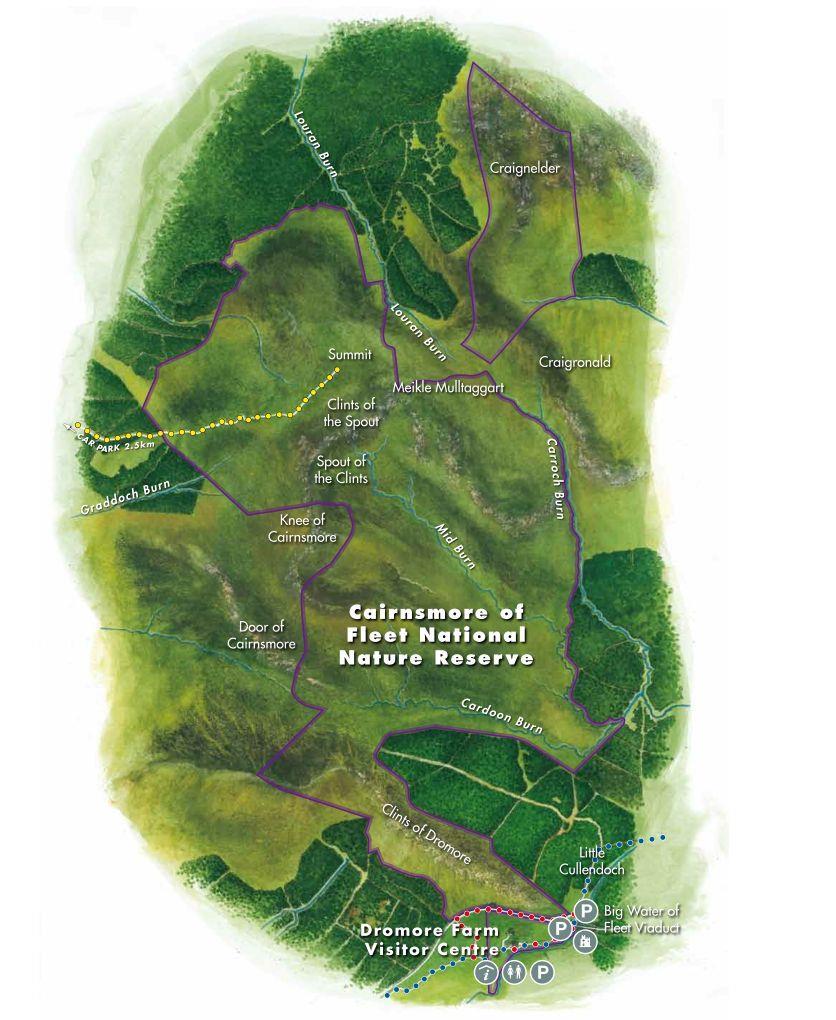
5 Reserve map

6 1 Introduction Situated in southwest Scotland the reserve covers 1,922 hectares (ha) and lies predominantly on the eastern side of the granite hill of Cairnsmore of Fleet. It extends from the visitor centre below the Clints of Dromore, to Craignelder in the north and from the Knee of Cairnsmore in the west, to Little Mulltaggart in the east. The reserve lies off the B796 between Creetown and Gatehouse of Fleet. It is open all year with a visitor centre and car park. From the visitor centre there are short circular walks of moderate ability of the in-bye farm, viaduct and Clints of Dromore. Picnic benches and further parking are available under the Big Water of Fleet viaduct, which straddles the River Fleet. To the west of the site, the summit path can be accessed via the Cairnsmore estate off the A75 at Palnure. The total land area within the NNR is 1,922 ha. Scottish Natural Heritage s (SNH) predecessor, the Nature Conservancy Council, purchased 1,314 ha of land from the Forestry Commission in 1974 and declared the NNR in A further 608 ha are subject to Nature Reserve Agreements with neighbouring landowners, which include the summit of Cairnsmore of Fleet. Cairnsmore of Fleet The site was chosen as representative of the granite uplands of Galloway and has continuity between un-afforested moorland and montane ground above the potential tree limit. The habitats present at Cairnsmore of Fleet were formerly widespread in the Southern Uplands, but have been much reduced over the past 60 years by land use changes from predominately hill farming and sporting interests to a greater proportion of forestry and recreational use. The national conservation designation in the UK is the Site of Special Scientific Interest (SSSI). Cairnsmore of Fleet was originally notified in 1968, it was re-notified as a SSSI in 1986 and again in The features for which Cairnsmore of Fleet is designated are listed in Table 1. The SSSI covers a wider area (3, ha) than the NNR. The NNR lies within the Galloway and Southern Ayrshire Biosphere. The Biosphere designation is awarded by The United Nations Educational, Scientific and Cultural Organisation (UNESCO) to areas renowned for their special environments which are valued by local people. The biosphere, one of over 650 around the world, covers over 5,000 square kilometres and is home to 95,000 people.
7 Table 1: Designated and qualifying features for Cairnsmore of Fleet Feature Blanket bog Upland assemblage Protected Area Cairnsmore of Fleet SSSI Cairnsmore of Fleet SSSI

8 2 The Natural and Cultural Heritage of Cairnsmore of Fleet NNR The reserve takes its name from Cairnsmore of Fleet, one of the most southerly of the high Galloway Hills. This is one of the wildest parts of southwest Scotland. Cairnsmore of Fleet sits in a commanding location overlooking the Cree Estuary. On a clear day views from the summit extend south across the Solway Firth to the Lake District and the Isle of Man, west across the Irish Sea to Ireland, and north over the Galloway Hills to Ayrshire and beyond. The reserve extends from the Clints of Dromore (92 metres (m)) in the south, to Craignelder (601m) in the north to the Cairnsmore summit (711m). Cairnsmore hill is a granite mass, oval in shape, measuring 8 kilometres (km) by 6km. The summit forms a distinctive ridge with high cliffs and screes along its eastern side. The lower ground is moorland with areas of blanket bog of varying depths of peat. The two most extensive habitats of the site are heath and bog. Both are similar in that they have varying amounts of heather on largely peaty soils. Very simply the bog is wet and the heath drier, although only by a matter of degrees! Typically, upland moorland, which includes bogs and heaths, develops in Scotland on summits or gentle slopes with an altitude of 250m to 1000m. The thickness of peat can be a distinguishing feature between heath and bog, with heathland peat being shallow and relatively dry. In bogs, the peat is deeper and wetter and may vary from 1.5m to over 10m in depth. In areas of bog where peat is thick its capacity to hold water is greater, Sphagnum moss creating poorly aerated, acidic and cold conditions. Because of this, decomposition is suppressed and the peaty soils are lacking in minerals and nutrients. Summit vegetation - the summit ridge of Cairnsmore of Fleet has two main types of mountain vegetation; montane grassland and dwarf shrub heath. The heath has species such as dwarf willow, stiff sedge and woolly fringe moss. These cover the gently sloping areas around the summit and the lower summit slopes. The grassland areas consist of taller vegetation where the dominant species are mat grass and blaeberry with heath rush. The montane grassland here was probably once heath that has been modified by grazing activity. Moorland - the heather moorland is the driest type of moorland; here heather, bell heather and blaeberry are some of the dominant plants. Although water is usually plentiful many of these plants appear to have adapted for living in drier conditions and have developed particular features to reduce water loss; these can be spiny or waxy leaves, hairs or pores arranged in grooves. Such plants are said to be xeromorphic. They may have developed these features because of the exposed and

9 windswept nature of Cairnsmore; this could mean they lose water by evaporation through their leaves or because the rate at which their roots can take in water is reduced in the cold and low oxygen condition of the peat. As ground conditions get wetter, cross-leaved heath, heath rush, purple moor grass, cotton grass and mat grass can be found. Blanket bog this is the wetter moorland; here there are numerous colourful mosses to be seen. These are mostly various species of sphagnum and tussocks of hair moss. Carnivorous plants, such as the round leaved sundew and common butterwort, are found on the blanket bog. These plants show yet another adaptation to living in the low nutrient environment; the sticky hairs on their leaves trap small insects, which the plants are able to digest through chemicals they produce in their leaves. Wildlife Birds - the reserve is an important breeding site for birds of mountain and moorland. Historically golden eagle bred on the cliffs and occasional sightings are still recorded. Peregrine falcon, merlin, kestrel, raven and buzzard still breed regularly. Hen harrier is a frequent visitor during winter months. Red grouse numbers have fluctuated greatly and are generally found in four main areas of the reserve. Black grouse can also be found in small numbers. Peregrine falcon Golden plover and dotterel have both been recorded nesting on the summit areas. Mammals - red deer use the main hill and central area of the reserve throughout the year, whilst around the boundary with forestry, roe deer can be seen. A herd of wild goats roam the reserve; it may be that they descended from animals abandoned by crofters during the 18 th and 19 th centuries. Small numbers of foxes, mountain hare and stoats occur. Brown hares are regularly seen close to the farmhouse or on the in-bye land as it is known. Amphibians and reptiles - common frogs and palmate newts are present in the damper areas around pools streams and ditches. Adders are present throughout as are common lizards. Slow worms have been recorded along the Clints of Dromore. Insects - dragonflies and damselflies can be seen hunting along the banks of the River Fleet or over bog pools.
10 Seventeen species of butterfly have been recorded on the site and over 120 species of moth. Other UK species of Conservation Concern found here include the small pearl bordered fritillary, large heath and broad bordered white underwing, a montane moth species associated with woolly fringe moss heath found at over 600m. Argent and sable, a daytime flying moth, is found over the open moorland and bogs. Beetles are also well represented; the golden green ground beetle is a nationally notable species. In recent years, heather beetle has caused problems. Its larvae feed on young shoots of heather and, as a result of mild winters and changing climatic conditions, numbers have escalated. As in other parts of Scotland, areas of heather have died back as a consequence

11 3 A history of Cairnsmore of Fleet Land Use The wildlife and habitats of Cairnsmore of Fleet NNR are a direct result of Man s management over hundreds of years. It is thought that during the medieval period land use in the area was primarily sheep and goat grazing and hunting for game. The Cistercian monks probably moved flocks onto Cairnsmore of Fleet every summer. It was not until the late 18 th and early 19 th centuries that land use changed. The introduction of enclosures and the clearances of small tenants, together with the introduction of a predominantly sheep based culture, with a few shepherds looking after large flocks, saw areas like Cairnsmore of Fleet supporting fewer people. It was during this period when sheep farming increased, with less emphasis on hunting, that small quantities of lead and other minerals were mined in the area. The railway, for which the viaduct was constructed in 1860, led to a boom in grouse shooting. Effectively from this point Cairnsmore of Fleet was divided in two. The western side of the hill was used principally for sporting purposes and some cattle grazing, whilst the eastern half was used primarily for sheep with sporting use a secondary interest. Big Water of Fleet Viaduct Three important changes in land use have taken place since the Second World War. First, sheep farming became the major use of the land. Secondly, sporting use declined in importance. Thirdly, much of the surrounding area was planted with coniferous forest.

12 Decline of Woodland Evidence from pollen in peat deposits shows that Galloway was once covered with alder, oak and birch forest, which was at its greatest extent during the Atlantic period, between 4000 and 6000 B.C. It is thought that the Cairnsmore of Fleet area was suitable for deciduous tree growth well into the historical period. During the Atlantic period it is thought the only parts of Scotland without trees would have been the mountain areas over 2000ft in the west. This would mean that the summit plateau has had no tree growth on it for at least 10,000 years. Records indicate that prior to the Roman invasion forest clearance in Galloway was insignificant. However the Roman legions appear to have spent much of their time occupied doing just that. Although documentary evidence from the end of the Roman period until the later Middle Ages is scarce, it is generally assumed that between 1400 and 1700 much of the natural woodland in lowland Scotland was removed. Fire was a powerful tool for clearing land and in the wars between the Scots and the English reference is often made to the burning of land. Maps of 1596 show small deciduous woods at Cullendoch and Cullendoch Moss up towards the Clints of Dromore; these woodlands no longer exist. Farming The earliest evidence for cultivation dates to the Bronze Age in the areas to the south which are rich in archaeological remains from this period. Farming, and in particular sheep rearing, increased in importance from Roman to medieval times. There is evidence of the Cistercian monks having granges (a country house with farm attached) and shielings (summer shepherd s huts) across the Galloway hills, and they probably used Cairnsmore of Fleet for summer grazing. These sheep-farming medieval monks are also said to have carried out muirburning to improve their grazing. The droving of cattle to markets in England first started in the early 1600s and it is likely that between the 14 th and 18 th centuries there was mixed grazing on all the Galloway moors. In 1684 there is mention of the land from Bardrochwood to the top of Cairnsmore of Fleet as being good pasture and some corn land. These comments are supported by General Roy s maps of 1745 which mark the riggs in fields caused by generations of ploughing at Little Cullendoch. The first enclosures started in the 1720s, when smaller tenants were cleared, to be replaced by introduction of a sheep monoculture, with a few shepherds looking after larger flocks. At this time the Cairnsmore of Fleet moors became the headquarters of

13 Billy Marshall, leader of the Galloway gypsies who, with his gang, demolished dykes on Cairnsmore of Fleet during The gang hid out in Billy Marshall s cave on the north end of Cairnsmore of Fleet, where they stored the spoils from their activities, which included smuggling. A report from the tenants of the Cuil reported up to 80 packhorses journeying past the Door of Cairnsmore laden with contraband. William Billy Marshall was reputedly born around 1672 in Ayrshire, surviving until around 1792, and if Cairnsmore was his headquarters, it may be that there was little farming on this land during his most active years. During the 18 th century, moor farms were said to have march (boundary) dykes and dykes around the in-bye. Attempts to improve moorland fertility were made by paring and burning. The top layer of turf was ploughed off, collected and burnt. The ash and charcoal was then spread and the area sown with oats the following summer. Maybe this was practiced on Cairnsmore, but repeated cropping in this way eventually exhausted the soil fertility, so that many landlords prohibited the practice. Cairnsmore of Fleet The commissioning of a detailed plan of Cullendoch and Dromore in 1810 possibly indicates the change from mixed pastoralism to sheep monoculture on Dromore. This was presumably done with a view to increasing the revenue from the farms. It is also likely that with this switch to a sheep monoculture, systematic muirburn was adopted to improve grazing for sheep. Before this time, mixed grazing would have meant the herbage was palatable to a wider range of graziers. There do not appear to have been any major changes in farming practice at Cairnsmore since the late 19 th century. However, during the 1960s the progressive
14 loss in the profitability of sheep farming led to many unprofitable upland farms being planted with conifers. Game Management It is likely that management for game has been as much a part of the relationship between man and the land as farming sheep has been. Evidence suggests that even early man may have burned forest underbrush to improve grazing for the animals he hunted. Probably the most significant event for Cairnsmore with regard for game was the opening of the Castle Douglas to Portpatrick railway in , for it is shortly after this (in 1868) that the first game-bag records are found. Since Cairnsmore was first opened up for commercial grouse shooting in the 1860s it is likely that strip burning for grouse was introduced. Indeed the whole of the Cairnsmore estate, apart from the summit, was strip burnt whilst leased to the Duke of Bedford. This continued until the 1950s. Apart from the adoption of muirburn practice, the other most significant management practice was probably the intensifying of vermin control. Indeed the attitude of the 19 th century landowner to vermin is well illustrated in the moor management chapter of Grouse and Grouse Moor by G Malcolm and A Maxwell, which lists every conceivable predatory and omnivorous mammal and bird as a threat to grouse. Despite this, there is no evidence to suggest that vermin on Cairnsmore were ever subjected to the level of control suggested above, although control did take place and reference of payments to under keepers of vermin money can be found. By that time raptors, magpies, crows, ravens, black backed and herring gulls, stoats, weasels, rats, hedgehogs, cats and foxes were probably controlled on Cairnsmore as intensively as on the rest of the estate. After the Second World War, records suggest that Dromore was only lightly keepered and evidence suggests that during the last century the use of Dromore for game was secondary to its sheep interest. However, this was not the case on the west side of the hill. Management on the estate for game intensified and regular payments were made to tenant farmers for the losses they incurred as a result. Increasingly the farming practices became uneconomic. The expenditure on game management produced results; grouse shooting before the war regularly saw 70 brace a day shot. About 40 people were employed in two squads for a day s drive and usually there were eight drives a season, with three guns per day. The south western slopes of Cairnsmore of Fleet, from the Door across to the Cuil, were reputed to be the best for grouse. After the war things started to change and shooting on Cairnsmore saw different beats being let to different shooting syndicates and the gradual decline of the importance of game management.
15 Introducing New Species 1891 saw the start of a concerted effort to introduce deer onto the estate. By 1907 a report states that a herd of red deer had become established. By 1914 they had been encouraged onto the moor and by the 1930s there were any amount of deer. Deer were not the only attempted introductions. Black partridges from India, quail and partridge are also listed. Other land uses Dromore Farm, with Clints of Dromore from Gatehouse Road Before 1845 some small-scale mining took place. Then in the mid 19 th century there was a boom, and the mines were quickly worked out. The Dromore lead mine was probably opened during the 1840s when extraction was mainly opencast. During the war the mine was also worked for copper and zinc. Four workers were employed, with two working underground. Undoubtedly the largest change in land use in the area over the last century was the move away from a sheep based land use to conifer forestry. Around Cairnsmore of Fleet this change has occurred since the last war.
16 A Brief History of Wildlife Recorded At Cairnsmore 1690 Cairnsmore is noted for its red deer and red grouse. Eagles are common and the rivers rich in salmon Grouse (both red and black) are in decline. Partridge, hare, woodcock, rabbit, badger, fox and polecat are present. Loch Grannoch has healthy numbers of Arctic charr, but salmon have declined in the River Fleet Golden eagles known to nest on Cairnsmore of Fleet Corncrake, water rail, partridge, bittern, osprey and polecat are on Cairnsmore of Fleet and at Loch Grannoch. Red deer and ptarmigan have disappeared. 1870s Wildcats have disappeared Green spleenwort fern is abundant on Cairnsmore. Starry saxifrage is present on the summit Red kites breed at Loch Grannoch Red deer are successfully re-introduced Buzzards cease breeding Peregrine falcon and raven are in decline. 1960s Golden eagles are still breeding Arctic Charr had disappeared from Loch Grannoch by this date. 1980s Peregrine falcon and raven numbers are increasing, buzzards are breeding, but golden eagles no longer breed on site. Records are made of moths, flies, dragonflies and beetles. Summary Over the last two centuries, changes in the vegetation of the area away from the natural deciduous woodland, with birch scrub, heath and montane vegetation at increasing altitude has resulted in a decline in species richness. The first major factor in this was the gradual and progressive destruction of deciduous woodland by Man s activity and climate change. A more rapid factor was the move to a sheep monoculture that necessitated the need for regular burning to retain stable heath vegetation. This change was strengthened by the increase in sporting for grouse, which also relied upon burning as a management tool. The scrub vegetation was replaced by a heather dominated habitat which itself has in places been replaced by one containing mat-grass, purple moor grass and bracken if burning and grazing are not finely balanced.
17 4 Management of Cairnsmore of Fleet NNR SNH and its predecessors have maintained the reserve using grazing as a tool to achieve, conservation objectives for the SSSI and the NNR. Although Cairnsmore of Fleet NNR was originally managed for wildlife, people are also encouraged to enjoy these special places too. Over the years visitor facilities have been designed and managed to ensure that people can enjoy the reserves without harming or disturbing the wildlife that lives there. Extensions to the reserve have been made through Nature Reserve Agreements (NRA) with neighbouring landowners. The upland nature of the site, the way forestry developed and the consequent lack of good in-bye land makes the farm uneconomic in farming terms. SNH ownership means that the habitat can be managed to maintain and, where possible, improve the natural heritage interest. In February 2000, SNH started a review of all of the then 71 NNRs in Scotland. Cairnsmore of Fleet NNR was one of six for which the case was re-examined as to how best it could fit the requirements of an NNR. A further review in 2015 concluded the Cairnsmore of Fleet NNR met the criteria for NNR status. In future the reserve will form an important part of the core area of Galloway and Southern Ayrshire Biosphere. Management of the natural heritage SNH have been working to restore upland habitats and improve the biodiversity on Cairnsmore of Fleet NNR. Management aimed at increasing the proportion of heather dominated vegetation at the expense of purple moor grass. This consisted in reducing grazing pressure by controlling wild herbivores on higher ground and using SNH s own sheep flock in the hills. In the past we also stimulated heather growth by burning and swiping heather. Logistical problems and poor weather conditions meant that until 2006, muirburning to the extent required had not been carried out for a number of years. Although some heather swiping has taken place since, this is limited by the wetness of the ground and the risk of damage to vegetation by tractors used for this task. Some experimentation with grazing by cattle to break up the purple moor grass and encourage dwarf shrub heath vegetation was tried prior to the outbreak in 2001 of Foot and Mouth Disease. This was not very successful, principally because the cattle used were not a hill breed. In head of more suitable cattle returned to a specific part of the hill. This second trial ended in Some culling of deer and feral goats takes place on the reserve, to ensure numbers are maintained at a level compatible with the conservation objectives for the NNR and with the needs of adjacent land managers. This control programme is in line with


18 an agreed management plan with stakeholders and land managers covering the wider area of the Galloway Hills During 2002/3 work started to improve the habitat for black grouse; this has included some small scale planting of rowan, silver birch, willow and alder extending native woodland within low level areas. Significant restructuring of the edges of the conifer plantations adjacent to the NNR has been implemented by the Forestry Commission following research on the biodiversity benefits this provides. This includes reducing the altitude of the upper edges of the forests and the re-planting of some edges with broad leaved trees and shrubs. In March 2003, we commissioned McCauley Land Research to undertake a habitat assessment of Cairnsmore of Fleet, with a further commission in Nov Then contractors developed an indicator which aimed at monitoring the health of the habitats by focussing on the condition of heather. The research results, which were a firm foundation from which to decide the future planning for the site, are now being re-assessed and the grazing pressure on the reserve will be reviewed for the latest Management Plan. Management for People People are encouraged to explore the southern end of the reserve at Dromore. There is a circular marked walk around the farm in-bye land. Access to the viaduct is particularly popular with local people. Recently a route onto the Clints of Dromore to the mid hill ground has been created. Further consideration will be given to an all-abilities walk around the lower ground. The national cycle route (NR7) passes through Dromore on its way to Clatteringshaws. Racks are provided for cyclists who wish to stop and explore the site. Path from Cairnsmore House to Cairnsmore Summit Further improvements are proposed and these include upgrade of the visitor centre, refreshing interpretation and signage The main access onto the Cairnsmore of Fleet summit follows the path up the western side of the hill, from near Cairnsmore House. A car parking area has been developed behind the Lodge by Graddoch Bridge to address Dromore Visitor Centre

19 problems with the old parking arrangements which could no longer cope with the current level of demand. Consideration is being given to encourage access onto the higher ground from the Queensway, near Murray s Monument, taking people up onto Craignelder, Meikle Mulltaggart and the summit. This would create a day-long walk north to south. Property Management SNH owns approximately 68% of the NNR, with the remainder being under Nature Reserve Agreements with two neighbouring landowners. There is an office on the reserve. We also have a farmhouse, and farm buildings, for which we have solely responsibility. The infrastructure includes the visitor centre at Dromore, the footpaths, small car parks, and picnic areas. All visitor facilities require regular maintenance. SNH has shared responsibility for the boundary, or march, fences. The equipment and vehicles used at Cairnsmore of Fleet are dedicated to the site, with occasional use by other reserves within Dumfries and Galloway as appropriate. SNH endeavours to follow best practice in its management. So management of the reserve ensures compliance with Health and Safety legislation; this includes updating the fire plan and carrying out risk assessments on a regular basis. As the reserve includes management of livestock, bio-security measures are also implemented on Cairnsmore of Fleet. SNH has aspirational sustainability criteria for its buildings, and intends to adopt best practice by conventional and innovative ways to demonstrate the benefits of this greener approach. This includes purchasing equipment and materials from sustainable local sources, recycling of materials, green energy generation and supply. Solar panels were installed to this end on the reserve office and the farmhouse in The NNR has been a warded a Green Tourism Business Award, Gold standard in 2015 in recognition of these. Summit cairn at Cairnsmore
20 Conclusion Cairnsmore of Fleet NNR is one of the most remote places in southwest Scotland. In the words of visitors it can give enjoyment of a wild, upland landscape accessible to a large number of people from a wide audience of experience and abilities. The awareness, understanding and enjoyment it provides is something that we are proud of and will build on in the years to come. Somewhere, everyone can enjoy, appreciate, understand and value this special place and the wildlife which depends on it.
21 5 Document properties Photographs & maps Photography by Lorne Gill/SNH, Andrew Bielinski Maps by Eleanor Charman, GIG, SNH. Acknowledgments The first edition (2007) of the Story of Cairnsmore of Fleet was been written by Kevin Carter (Reserve Manager) and Susan Luurtsema (Managed Sites Officer) and approved by Chris Miles (Area Manager Dumfries and Galloway). This second edition of The Story of Cairnsmore of Fleet has been edited by Francois Chazel (Reserve Manager) and Susan Luurtsema (Operations Officer), and approved by Jonathan Warren (Operations Officer Southern Scotland). Links For information about Scotland s National Nature Reserves and further information about Cairnsmore of Fleet NNR please go to: For information on the protected areas associated with Cairnsmore of Fleet NNR please go to: Other useful links: Scottish Natural Heritage Joint Nature Conservation Committee
Appendices A (Our ambition for nature (A3 plan) and further information)
 and further information)") Appendices A (Our ambition for nature (A3 plan) and further information) Penny Hill Farm Nature Conservation vision Key: Tenancy boundary Meadow restoration & Mowing/meadow F33 Mowing/meadow Progress towards
Appendices A (Our ambition for nature (A3 plan) and further information) Penny Hill Farm Nature Conservation vision Key: Tenancy boundary Meadow restoration & Mowing/meadow F33 Mowing/meadow Progress towards
PRIORITY HABITAT SURVEY 2017 SWALEDALE. Summary. July 2018
 PRIORITY HABITAT SURVEY 2017 SWALEDALE Summary July 2018 Conservation & Monitoring Report No: Lead Author(s): Tony Serjeant & Sue Thurley Incorporating comments from: Gary Smith & Gordon Haycock (16/07/18)
Designated Sites. Headlines
 Designated Sites Headlines Over 36% of the Sheffield district is covered by sites with European, national or local designation. These offer valuable habitats to wildlife, with some level of protection,
Countryside Trails Dunkeld
 R A N G E R S E RV I C E Countryside Trails Dunkeld WELCOME Welcome to this southern end of Atholl Estates. The countryside here is a wonderful blend of lochs, woodland and heather moor. There is a large
APPENDIX 3: DESIGNATED SITES IN THE ITDMG AREA
 APPENDIX 3: DESIGNATED SITES IN THE ITDMG AREA INTRODUCTION The Inveraray & Tyndrum DMG area is moderately heavily designated, containing a number of high profile sites of national importance. In total,
Northumberland National Park:
 Northumberland National Park: Cottage's Phenomenal "Backyard" At Homildon Cottage, we are fortunate enough to have the Northumberland National Park right on our doorstep: our garden fence is the boundary
Yorkshire Dales classification of protected areas into IUCN Management Categories. Mark Fisher, November 2013 Wildland Research Institute
 Yorkshire Dales classification of protected areas into IUCN Management Categories Mark Fisher, November 2013 Wildland Research Institute Ingleborough National Nature Reserve Nesting of protected areas
Rough Haugh Wood Midmar, near Torphins, Aberdeenshire wild acres of undisturbed woodland habitat for 21,000 (freehold) [#A895]
![Rough Haugh Wood Midmar, near Torphins, Aberdeenshire wild acres of undisturbed woodland habitat for 21,000 (freehold) [#A895]](/thumbs/86/93824356.jpg "Rough Haugh Wood Midmar, near Torphins, Aberdeenshire wild acres of undisturbed woodland habitat for 21,000 (freehold) [#A895]") WOODS 4 SALE Phone: 01248 364 362 www.woods4sale.co.uk UK Woodland & Woods For Sale: Specialising in the Sales of Small Woodlands in England, Scotland and Wales for Recreation, Wildlife Conservation and
WOODS 4 SALE Phone: 01248 364 362 www.woods4sale.co.uk UK Woodland & Woods For Sale: Specialising in the Sales of Small Woodlands in England, Scotland and Wales for Recreation, Wildlife Conservation and
North Meadow National Nature Reserve
 Leaflet produced with the support of Cricklade Town Council. North Meadow National Nature Reserve For further information about North Meadow contact: The Senior Reserve Manager The Ebworth Centre, The
Management Issues in Atlantic N2K sites - a personal view from the Far West!
 National Parks and Wildlife Service of the Department of Arts, Heritage, Regional, Rural and Gaeltacht Affairs Management Issues in Atlantic N2K sites - a personal view from the Far West! 2 nd Atlantic
1. INTRODUCTION 2. CURRENT STATUS
 LOWLAND HEATHLAND AND LOWLAND DRY ACID GRASSLAND IN OXFORDSHIRE UK Biodiversity Group - Priority Species associated with heathland Nightjar Linnet Dingy mocha moth Grey scalloped bar moth, Other Associated
Silver-washed Fritillaries in the Straits Inclosure in July
 ALICE HOLT FOREST Hampshire from www.discoverbutterflies.com the website for the book Discover Butterflies in Britain D E Newland Silver-washed Fritillaries in the Straits Inclosure in July Alice Holt
Morning Copse near Maidstone, Kent acres of Ancient Woodland with a pond, bluebells and mature oak. 26,500 (freehold)
") WOODS 4 SALE Phone: 01248 364 362 www.woods4sale.co.uk UK Woodland & Woods For Sale: Specialising in the Sales of Small Woodlands in England, Scotland and Wales for Recreation, Wildlife Conservation and
WOODS 4 SALE Phone: 01248 364 362 www.woods4sale.co.uk UK Woodland & Woods For Sale: Specialising in the Sales of Small Woodlands in England, Scotland and Wales for Recreation, Wildlife Conservation and
SECTION ONE. Scotland s National Parks and National Nature Reserves Ten Things You Might Not Know
 SECTION ONE Scotland s National Parks and National Nature Reserves Ten Things You Might Not Know 5 Ten Things You Might Not Know... 1. SCOTLAND S NATIONAL PARKS AND NATIONAL NATURE RESERVES ARE BEAUTIFUL,
628: BELOVEZHSKAYA PUSHCHA STATE NATIONAL PARK (BELARUS)
") WORLD HERITAGE NOMINATION - IUCN SUMMARY 628: BELOVEZHSKAYA PUSHCHA STATE NATIONAL PARK (BELARUS) Summary prepared by WCMC/IUCN (April 1992) based on the original nomination submitted by the Government
WORLD HERITAGE NOMINATION - IUCN SUMMARY 628: BELOVEZHSKAYA PUSHCHA STATE NATIONAL PARK (BELARUS) Summary prepared by WCMC/IUCN (April 1992) based on the original nomination submitted by the Government
A summary of Draft Makara Peak Mountain Bike Park Master Plan
 A summary of Draft Makara Peak Mountain Bike Park Master Plan OVEMBER 216 Image: Peter Marshall 2 3 Introduction Since it was established in 1998, the Makara Peak Mountain Bike Park (Makara Peak) has grown
The Chilterns Conservation Board The Lodge Station Road Chinnor Oxon OX39 4HA
 The Chilterns Conservation Board The Lodge Station Road Chinnor Oxon OX39 4HA Tel: 01844 355500 Fax: 01844 355501 E Mail: office@chilternsaonb.org www.chilternsaonb.org PRESS RELEASE Chilterns Commons
EXPLORING BIOMES IN GORONGOSA NATIONAL PARK
 EXPLORING BIOMES IN GORONGOSA NATIONAL PARK ABOUT THIS WORKSHEET This worksheet complements the Click and Learn Gorongosa National Park Interactive Map (http://www.hhmi.org/biointeractive/gorongosa-national-park-interactive-map),
Biosphere Reserves of India : Complete Study Notes
 Biosphere Reserves of India : Complete Study Notes Author : Oliveboard Date : April 7, 2017 Biosphere reserves of India form an important topic for the UPSC CSE preparation. This blog post covers all important
ABERDEEN HARBOUR EXPANSION PROJECT November Volume 3: Technical Appendices. Appendix 17-B SLVIA - ABERDEEN GREEN SPACE NETWORK
 ABERDEEN HARBOUR EXPANSION PROJECT November 2015 Volume 3: Technical Appendices Appendix 17B SLVIA ABERDEEN GREEN SPACE NETWORK APPENDIX 17B: SLVIA ABERDEEN GREENSPACE NETWORK 17B SLVIA Aberdeen green
Unimproved meadow with extensive riverside frontage and a bank of mixed hardwoods with good hard track access in the heart of rural South Wales.
 WOODS 4 SALE Phone: 01248 364 362 www.woods4sale.co.uk UK Woodland & Woods For Sale: Specialising in the Sales of Small Woodlands in England, Scotland and Wales for Recreation, Wildlife Conservation and
Yard Creek Provincial Park. Management Plan
 Yard Creek Provincial Park Management Plan Draft January 2010 Yard Creek Provincial Park Management Plan Approved by: telàlsemkin/siyam/chief Scott Benton Bill Williams Squamish Executive Director ation
GEOGRAPHY AND HISTORY
 GEOGRAPHY AND HISTORY YEAR 1, PART 1 www.vicensvives.es Contents 01 Our planet Earth 02 The representation of the Earth: maps 03 The Earth s relief 04 Rivers and seas 05 Weather and climate 06 Climates
Corlea Archaeological. Settlement and Biodiversity. Project.
 Corlea Archaeological Settlement and Biodiversity Project. Pic 1: Rehabilitated and re-colonised bog. September 2013 1 The Corlea Archaeological Settlement and Biodiversity Project. TABLE OF CONTENTS 1.
Sutton and Hollesley Heaths Walk Guide
 Outstanding Landscapes Sutton and Hollesley Heaths Walk Guide Explore the unique and rare landscape of the Sandlings heath and its diversity of wildlife and history. The Suffolk Coast & Heaths Area of
EUROPEAN COMMISSION DG XI.D.2. COUNCIL DIRECTIVE 79/409/EEC on the conservation of wild birds. and
 EUROPEAN COMMISSION DG XI.D.2 COUNCIL DIRECTIVE 79/409/EEC on the conservation of wild birds and COUNCIL DIRECTIVE 92/43/EEC on the conservation of natural habitats and of wild fauna and flora STANDARD
CRAZY HORSE TRAIL GUIDE
 CRAZY HORSE TRAIL GUIDE Abridged Version: July 2016 This is a short form of our interpretive trail guide for the Crazy Horse Trail. The full version of the guide has a more detailed description of the
Draft Strategic Plans for Coillte s eight Business Area Units ( )
") Draft Strategic Plans for Coillte s eight Business Area Units (2011-2015) Response to Public Consultation from Mountaineering Ireland April 2013 1 Introduction Mountaineering Ireland welcomes this opportunity
Draft Strategic Plans for Coillte s eight Business Area Units (2011-2015) Response to Public Consultation from Mountaineering Ireland April 2013 1 Introduction Mountaineering Ireland welcomes this opportunity
Newlands Corner Leaflet 08:Newlands Corner Leaflet 5/10/09 11:58 Page 1
 Newlands Corner Leaflet 08:Newlands Corner Leaflet 5/10/09 11:58 age 1 St Martha s is the start of the Downs Link, a 33-mile long distance trail linking the North Downs Way with the South Downs Way at
Colorado Life Zone Scavenger Hunt
 Colorado Life Zone Scavenger Hunt Below are worksheets created for all the habitats or life zones. They were designed with the intention of breaking the class up into small groups, and having students
Natural Heritage. Published on Turist Information of Suances (http://turismo.suances.es)
") Published on Turist Information of Suances (http://turismo.suances.es) Home > Printer-friendly PDF > Natural Heritage Natural Heritage Suances belongs to a natural region called?coast Strip? or?la Marina?.
Published on Turist Information of Suances (http://turismo.suances.es) Home > Printer-friendly PDF > Natural Heritage Natural Heritage Suances belongs to a natural region called?coast Strip? or?la Marina?.
Land Management Summary
 photo credit: ANGAIR Anglesea Heath Land Management Summary The Anglesea Heath (6,501 ha) was incorporated into the Great Otway National Park in January 2018. This provides an opportunity to consider the
Conservation Area Management Statement
 Conservation Area Management Statement Miller Creek Wildlife Area Resolution #: Approval: Issue Date: Date of Last Revision: Table of Contents 1. Purpose....... 1 2. Property Description...... 1 2.1. Legal
approve the Rural Asset Management Plan at Annex 1; and
 Rural Land Asset Management Plan Decision Summary 1. This paper seeks the Board s approval of the attached plan for the of SNH s landholding and proposes seeking the Cabinet Secretary s support for our
Following the initial soil strip archaeology is sprayed up prior to planning and excavation
 Barton Quarry & Archaeology Over the past half century quarries have been increasingly highlighted as important sources of information for geologists, palaeontologists and archaeologists, both through
Wicklow Mountains Path Survey
 Wicklow Mountains Path Survey Glenmacnass Tonelagee Start to Finish: O 114 030 to O 085 016 Altitude (lowest highest): 370m 817m Weather: Sunny day, hot Access: Military Road, Glenmacnass Surveyed by:
TOWPATH MOWING GUIDELINES
 TOWPATH MOWING GUIDELINES 24 September 2007 CONTENTS Introduction Scope and Status of Guidelines Influences on the Guidelines Health and Safety Biodiversity INTRODUCTION Towpath management is a key issue
Recreational Carrying Capacity
 9 th Annual Caribbean Sustainable Tourism Conference Recreational Carrying Capacity Graham C Barrow What is Recreational Carrying Capacity? It s not about fixing absolute numbers of visitors/tourists that
SHEEPLEAS. Visitor Guide and Self-guided Trails
 SHEEPLEAS Visitor Guide and Self-guided Trails Sheepleas The Sheepleas is an interesting mix of woodland, scrub and open grassland, situated on the chalk of the North Downs. This diversity of habitats
Pembina Valley Provincial Park. Draft Management Plan
 Pembina Valley Provincial Park Draft Management Plan 2 Pembina Valley Provincial Park Table of Contents 1. Introduction... 3 2. Park History... 3 3. Park Attributes... 3 3.1 Natural... 3 3.2 Recreational...
Survey of Deadwater Fell and Peel Fell
 4 December 2014 Survey of Deadwater Fell and Peel Fell Team: John Barnard, Chris Crocker, Richard Cooper and Graham Jackson 1) Introduction Deadwater Fell (Hill 3542, Section 33, OS 1:50000 Map 80, OS
Backgrounder Plains Bison Reintroduction to Banff National Park
 Backgrounder Plains Bison Reintroduction to Banff National Park Introduction The five-year reintroduction project is a small- scale initiative that would inform future decisions regarding the feasibility
B HALL RANCH FISHTAIL, MONTANA
 Brochure Courtesy of: B HALL RANCH FISHTAIL, MONTANA w w w. m c c a s l i n l a n d. c o m Page 1 LOCATION The Hall Ranch is ideally located in the foothills of the Beartooth Mountains, approximately 5
1.1.1 Landscape character This is the upper part of a bowl-shaped landform, extending east from the Rothiemurchus character area, contained by the
 1.1 Glen More 1.1.1 Landscape character This is the upper part of a bowl-shaped landform, extending east from the Rothiemurchus character area, contained by the arc of the high granite pluton of the Cairngorms
MANAGEMENT DIRECTION STATEMENT June, 1999
 Thompson River District MANAGEMENT DIRECTION STATEMENT June, 1999 for Roche Lake Provincial Park Ministry of Environment Lands and Parks BC Parks Division Table of Contents I. Introduction A. Setting
Cheshire Ecology Ltd.
 Cheshire Ecology Ltd. What is an NVC Survey? 22 March 2014 1 Introduction A National Vegetation Classification (NVC) survey is a detailed botanical survey of a site. They are normally required for large
Europarc Atlantic Isles Exchange Programme: Germany: Rhön Mountains Summary of Events
 Europarc Atlantic Isles Exchange Programme: Germany: Rhön Mountains Summary of Events Sunday 10 th - Monday 18 th June 2018 Christopher Watt North Pennines AONB Partnership-Peatland Conservation Trainee
Appendix 7 Local Green Spaces - Detailed Evidence
 Appendix 7 Local Green Spaces - Detailed Evidence Neigh Bridge Country Park, Somerford Keynes General information Neigh Bridge Country Park is situated at the southern entrance to Somerford Keynes village.
Region 1 Piney Woods
 Region 1 Piney Woods Piney Woods 1. This ecoregion is found in East Texas. 2. Climate: average annual rainfall of 36 to 50 inches is fairly uniformly distributed throughout the year, and humidity and temperatures
Section 1 Introduction to Sustainable Tourism
 Section 1 Introduction to Sustainable Tourism What is Sustainable Tourism? In defining Sustainable Tourism it is useful to start with an understanding of sustainable development. A term popularised following
Watchorn Provincial Park. Management Plan
 Watchorn Provincial Park Management Plan 2 Watchorn Provincial Park Table of Contents 1. Introduction... 3 2. Park History... 3 3. Park Attributes... 3 3.1 Natural... 4 3.2 Recreational... 4 3.3 Additional
Specification for Grip blocking using Peat Dams
 Technical Guidance Note 1 Specification for Grip blocking using Peat Dams 1. Introduction Moorland drains (grips) have been dug across much of the Yorkshire upland peatlands. Many of these grips have become
Wicklow Mountains Path Survey
 Wicklow Mountains Path Survey Ballinacor Croaghanmoira Fananierin Start to Finish: T 11723 86602 to T 11175 89057 Altitude (lowest highest): 385m 664m Weather: Hot Access: Coolgarrow forest entrance Surveyed
Summary of prescribed fires in Prince Albert National Park 2015
 Summary of prescribed fires in Prince Albert National Park 2015 Prince Albert National Park conducted four controlled fires in spring 2015, plus an additional fire in October. Fuel Management for Hazard
Lowland Heathland in Nottinghamshire: Progress towards the LBAP
 Lowland Heathland in Nottinghamshire: Progress towards the LBAP Norma Saunders, Chief Executive Officer of The Sherwood Forest Trust Chair of Nottinghamshire Biodiversity Action Group The Seed of an idea
Participating quarry information (Long version)
") Participating quarry information (Long version) 1. Contact information Company: PT Indocement Tunggal Prakarsa Tbk. Cirebon Plant Quarry: Latitude / Longitude: City: Region: Country: Cirebon Quarry 6 o
Participating quarry information (Long version) 1. Contact information Company: PT Indocement Tunggal Prakarsa Tbk. Cirebon Plant Quarry: Latitude / Longitude: City: Region: Country: Cirebon Quarry 6 o
 AGREEMENT Between Director of the Białowieża National Park, based in Białowieża (Poland) and Director of the National Park Bialowieża Forest, based in Kamieniuki (Belarus) and Head Forester of the Białowieża
Looking north from the SW shieling site with Lub na Luachrach in the foreground
 Looking north from the SW shieling site with Lub na Luachrach in the foreground Upper Gleann Goibhre - Shieling sites Two shieling sites in the upper reaches of the Allt Goibhre were visited and recorded
STATEMENT OF SIGNIFICANCE
 SECTION 2 1 STATEMENT OF SIGNIFICANCE Over the centuries, man has left his traces on our wild uplands, and these age-old survivals are an essential part of their value and interest. The little prehistoric
Coast Path Survey Stretch 09 Shalfleet Mill to Thorness Bay
 Coast Path Survey Stretch 09 Shalfleet Mill to Thorness Bay Overview Map of stretch Introduction This stretch of Island coast covers several salt marsh creeks backed by grazing land and woodland on the
Map 1.1 Wenatchee Watershed Land Ownership
 Map 1.1 Wenatchee Watershed Land Ownership Map 1.1 Wenatchee Watershed Land Ownership The Wenatchee watershed lies in the heart of Washington state in Chelan County. Just larger than the state of Rhode
Councillor Briefing on Elvetham Chase
 Councillor Briefing on Elvetham Chase In partnership with the Calthorpe Estate, Wates Developments vision for Elvetham Chase is to provide an outstanding new community for Hart District that will become
Chapter 2: Site Analysis Topography (L)
") Chapter 2: Site Analysis Topography (L) Meigle Hill AOD 421m Melrose Gait Gala Hill AOD 100m AOD 252m AOD 75m Eildon Hill AOD 422m Tweedbank is part of a valley conurbation of distinct villages and towns
Chapter 2: Site Analysis Topography (L) Meigle Hill AOD 421m Melrose Gait Gala Hill AOD 100m AOD 252m AOD 75m Eildon Hill AOD 422m Tweedbank is part of a valley conurbation of distinct villages and towns
Official Journal of the European Union L 337/43
 22.12.2005 Official Journal of the European Union L 337/43 PROTOCOL on the implementation of the Alpine Convention of 1991 in the field of tourism Tourism Protocol Preamble THE FEDERAL REPUBLIC OF GERMANY,
Wallace Lake Provincial Park. Management Plan
 Wallace Lake Provincial Park Management Plan 2 Wallace Lake Provincial Park Table of Contents 1. Introduction... 3 2. Park History... 3 3. Park Attributes... 4 3.1 Natural... 4 3.2 Recreational... 4 4.
CORPORATE SPONSORSHIP PROPOSAL
 CORPORATE SPONSORSHIP PROPOSAL Conservation n Credibility n Community EXTINCTIONN! IS NOT AN OPTIO BACKGROUND Our vision is to play a key role in the Tasmanian devil insurance breeding program to ensure
Unlocking Our Coastal Heritage Project: Crane Castle Promontory Fort, Illogan, Cornwall
 Unlocking Our Coastal Heritage Project: Crane Castle Promontory Fort, Illogan, Cornwall As part of a wider project funded by the Rural Development Programme for England (RDPE) and administered through
Eglwyseg Mountain a landscape of prehistoric cairns and later industry
 Eglwyseg Mountain a landscape of prehistoric cairns and later industry Walk Information: Maps: OS Explorer 256 Distance: 5.3 miles / 8.5 kilometres (linear) or up to 9.6 miles / 15.5 kilometres (circular)
The following criteria were used to identify Benchmark Areas:
 7.0 BENCHMARK AREAS The Churn Creek Protected Area offers a significant opportunity to learn more about how grassland ecosystems function. One of the key tools that will be used to monitor larger grassland
Appendix 8.D Water Vole and Otter Survey Report
 Appendix 8.D Water Vole and Otter Survey Report Entec UK Limited Entec UK Limited Water Vole and Otter Survey Report June 2009 Final Client Job Name Report title File reference E.ON Renewables Ltd Water
Tranquil Wood Rhewl, near Ruthin, Denbighshire acres of medal-winning hardwoods for 26,500 (freehold)
") WOODS 4 SALE Phone: 01248 364 362 www.woods4sale.co.uk UK Woodland & Woods For Sale: Specialising in the Sales of Small Woodlands in England, Scotland and Wales for Recreation, Wildlife Conservation and
WOODS 4 SALE Phone: 01248 364 362 www.woods4sale.co.uk UK Woodland & Woods For Sale: Specialising in the Sales of Small Woodlands in England, Scotland and Wales for Recreation, Wildlife Conservation and
Bedfordshire and Luton Species Action Plan: Hazel Dormouse
 Bedfordshire and Luton Species Action Plan: Hazel Dormouse Released November 2006 Last updated July 2010 Hazel dormouse, Muscardinus avellanarius Photo by Björn Schulz Bedfordshire Dormouse Group Hazel
Draft Concept Plan. for the. Proposed Saskatoon Mountain Provincial Recreation Area
 Draft Concept Plan for the Proposed Saskatoon Mountain Provincial Recreation Area April 2014 Table of Contents INTRODUCTION... PROPOSAL SUMMARY... 1.0 DESCRIPTION OF THE PROPOSED SASKATOON MOUNTAIN PROVINCIAL
12 NIGHT/13 DAY FAMILY SAFARI NORTHERN TANZANIA
 12 NIGHT/13 DAY FAMILY SAFARI NORTHERN TANZANIA Day One - Lake Manyara On arrival into Kilimanjaro you are met and transferred directly to Lake Manyara National Park. Located 125 km west of Arusha town,
The Landscapes of Scotland. 71 Lower Tweedale
 s 71-79 71 Lower Tweedale 72 Carrick 73 Galloway Hills 74 Lowther Hills 75 Rhins of Galloway 76 The Machars 77 Stewartry Coast 78 Dumfries Plain 79 Cheviots 71 Lower Tweedale Broad valleys of mixed pasture,
SUMMER VILLAGE OF SILVER SANDS. Municipal Development Plan
 SUMMER VILLAGE OF SILVER SANDS Municipal Development Plan Bylaw 253-2014 Adopted August 22, 2014 Summer Village of Silver Sands Municipal Development Plan Bylaw No. 253-2014 Page 2 1 INTRODUCTION 1.1 SETTING
relax under wide skies
 relax under wide skies Savour the atmosphere and sense of remoteness to be enjoyed on Romney Marsh throughout the year. WALK 8 Stone-in-Oxney 61 WALK 8 Stone-in-Oxney 62 62 Crown copyright 100019238. Stone
IOW Ramblers Submission Paper to the Sept 2016 ROW Improvement Plan Consultation.
 IOW Ramblers Submission Paper to the Sept 2016 ROW Improvement Plan Consultation. The current Island Rights of Way Improvement Plan is a comprehensive document and much of its content is still relevant
Mountain Goats and Winter Recreation November 17, 2011
 Mountain Goats and Winter Recreation November 17, 2011 Summary Mountain goats need protection from disruption and displacement in their winter feeding areas by motorized and non-motorized recreationists
West Wirral (Dee Estuary)
") View of Hilbre Island from West Kirby with walkers at low tide. West Wirral (Dee Estuary) West Kirby is the start of the 12 mile long Wirral Way, the backbone of Wirral Country Park, the old Hooton to
View of Hilbre Island from West Kirby with walkers at low tide. West Wirral (Dee Estuary) West Kirby is the start of the 12 mile long Wirral Way, the backbone of Wirral Country Park, the old Hooton to
Sasagiu Rapids Provincial Park. Draft Management Plan
 Sasagiu Rapids Provincial Park Draft Management Plan 2 Sasagiu Rapids Provincial Park Table of Contents 1. Introduction... 3 2. Background and Park Attributes... 3 2.1 Park History.... 3 2.2 Natural Features...
Current conditions. Guatemala's Maya Biosphere Reserve. No clear idea of speed of deforestation. Deforestion by pollen analysis
 Current conditions Most obvious human transformation is cutting of forests Guatemala's Maya Biosphere Reserve An Eco-Friendly Adventure Along the Maya Trails Key ecological roles: repository for biodiversity
DOYLE SPRINGS PLANNING UNIT Kern-Tule River Watershed
 Existing Conditions & Uses Overview Consists of a mostly forested parcel with small hydropower developments and part of a private recreation cabin development, along with two small transmission line corridor
ROBERTS CREEK PROVINCIAL PARK MASTER PLAN. November, 1981
 Ministry of Lands, Parks and Housing Parks and Outdoor Recreation Division Park Operations Branch North Vancouver, B. C. ROBERTS CREEK PROVINCIAL PARK MASTER PLAN November, 1981 Mr. G. Trachuk Director
CARLUNGIE EARTH HOUSE
 Property in Care (PIC) ID: PIC015 Designations: Scheduled Monument (SM90059) Taken into State care: 1953 (Guardianship) Last reviewed: 2004 HISTORIC ENVIRONMENT SCOTLAND STATEMENT OF SIGNIFICANCE CARLUNGIE
CAIRNGORMS NATIONAL PARK AUTHORITY
 CAIRNGORMS NATIONAL PARK AUTHORITY Title: Prepared by: REPORT ON CALLED-IN PLANNING APPLICATION ANDREW TAIT, (PLANNER, DEVELOPMENT CONTROL) DEVELOPMENT PROPOSED: REFERENCE: APPLICANT: FULL PLANNING PERMISSION
Marchand Provincial Park. Management Plan
 Marchand Provincial Park Management Plan 2 Marchand Provincial Park Table of Contents 1. Introduction... 3 2. Park History... 3 3. Park Attributes... 4 3.1 Natural... 4 3.2 Recreational... 4 3.3 Additional
ANAGEMENT. LAN November, 1996
 M ANAGEMENT P LAN November, 1996 for Paul Lake Provincial Park Ministry of Environment, Lands and Parks BC Parks Department Paul Lake Provincial Park M ANAGEMENT P LAN Prepared by BC Parks Kamloops Area
Dungeness Recreation Area County Park Master Plan
 Dungeness Recreation Area County Park Public Outreach Meeting October 10, 2007 Project Overview USFWS Site Dungeness Recreation Area County Park Meeting Objectives: Re-Introduce project; provide status
1. What are the problems with tourism in Jordan? 2. How is sustainable tourism being encouraged?
 Jordan 1. What are the problems with tourism in Jordan? 2. How is sustainable tourism being encouraged? TAB 1 QUESTION - What are the problems with tourism in Jordan? Before looking into tourism in Jordan
Elephant. Buffalo. Kudu. Warthog
 ELEPHANT: Loxodonta africana 7000 kg HABITAT: Grasslands, savanna, and woodlands DIET: Herbivore (browser) Leaves and fruits from trees and shrubs. Elephants will knock down trees if they cannot reach
Strathaird and Torrin Estates Management Plan
 Strathaird and Torrin Estates Management Plan 2014 2019 finalised April 2014 Photo Keith Brame 1 1. Introduction... 3 2. Vision... 3 3. Aims and Objectives... 3 4. Actions... 3 5. Additional information...
Hudson Bay Lowlands Proposed Protected Areas
 Hudson Bay Lowlands Proposed Protected Areas Hudson Bay Lowlands Proposed Protected Areas The Protected Areas Initiative has identified portions of the Hudson Bay Lowlands region that have significant
Limestone terraces (in the distance) and woodland on hills in the Upper Wharfedale valley
 and woodland on hills in the Upper Wharfedale valley") GRASSINGTON North Yorkshire from www.discoverbutterflies.com the website for the book Discover Butterflies in Britain D E Newland 2009 Limestone terraces (in the distance) and woodland on hills in the
GRASSINGTON North Yorkshire from www.discoverbutterflies.com the website for the book Discover Butterflies in Britain D E Newland 2009 Limestone terraces (in the distance) and woodland on hills in the
Community Wildlife Conservation Award for 2006
 Community Wildlife Conservation Award for 2006 The Community Wildlife Service Award is made each year to recognise organisations which make a significant contribution to the preservation of Australian
Participating quarry information
 Participating quarry information 1. Contact information Company: Sand & Grus AB Jehander Quarry: Latitude / Longitude: City: Region: Country: Löten 59.422972 N / 17.582068 E Munsö Stockholm Sweden 2. General
The Alpine Flowers of Ben Lawers
 The Alpine Flowers of Ben Lawers Naturetrek Tour Itinerary Outline itinerary Day 1 Day 2/3 Day 4 Arrive Killin Ben Lawers Lochan na Lairige Departs August Focus Plants and general natural history Grading
Department of Environment, Climate Change & Water NSW. Stakeholder feedback
 Department of Environment, Climate Change & Water NSW Stakeholder feedback 1 Stakeholders group Blue Gum High Forest Group Guardians of Lane Cove NP Sydney Metropolitan Wildlife Service Ku-ring-gai Historical
2.0 PARK VISION AND ROLES
 2.0 PARK VISION AND ROLES 2.1 Significance in the Protected Area System Marble Range and Edge Hills provincial parks protect 6.8% of the Pavillion Ranges Ecosection, which is located in the Southern Interior
Brador hills biodiversity reserve
 Brador hills biodiversity reserve September 2003 1. Plan and description 1.1. Geographic location, boundaries and dimensions The plan of the proposed Brador hills biodiversity reserve and its location