Appreciations of the Wild Land context of the site
|
|
|
- Laurel Bradford
- 6 years ago
- Views:
Transcription
1 A Site Too Far A visual statement by Rannoch people to demonstrate that the proposed wind farm on Talladh a Bheithe Estate would be an unacceptable intrusion into an iconic part of Scotland s remaining and highly cherished wild land, and would be incompatible with the current national planning policies. 1

2 Appreciations of the Wild Land context of the site Ben Alder to Rannoch this area has a greater sense of remoteness than any other in the central highlands. There are no public roads within the area and the only two roads near its margins are at a great distance from the hills. Within lies Ben Alder, fascinating in its variety of corrie and ridge and with a definite air of inaccessibility adding to its attraction. Views both far and near (from the Carn Dearg Sgor Gaibhre Beinn Pharlagain ridge) of the great stretch of Rannoch Moor and of Strath Ossian s Ushaped trench are particularly satisfying. (approaching from the south) a view of great splendour steadily unfolds with the length of Loch Ericht stretching into the distance. Above it, scarped slopes to the east and the unrelenting angle of those to the west beneath Sron Coire na h-iolaire are redolent of the glacier that oversteepened these walls. (SMC District Guide to the Central Highlands, ISBN , pages and 153.) The dramatic landform is the dominant characteristic of the area. The topography is varied, ranging from massive, louring hills to more delicate, dissected peaks. It also forms long, deep glens that contain the striking large-scale lochs that are another feature of the landscape. The area is located in the centre of the Highlands between Strathspey and the west. the high ground is a barrier to communication and the distances from other settlements and routes from the south of the area further inhibits traffic. The bulk of the study area, south of the A86, is served only by estate tracks and footpaths. This heightens the sense of remoteness and semi-wilderness which is one of the main features of being in the area. (SNH s Landscape Character Assessment of Ben Alder and nearby Estates no. 120, page 11) 2
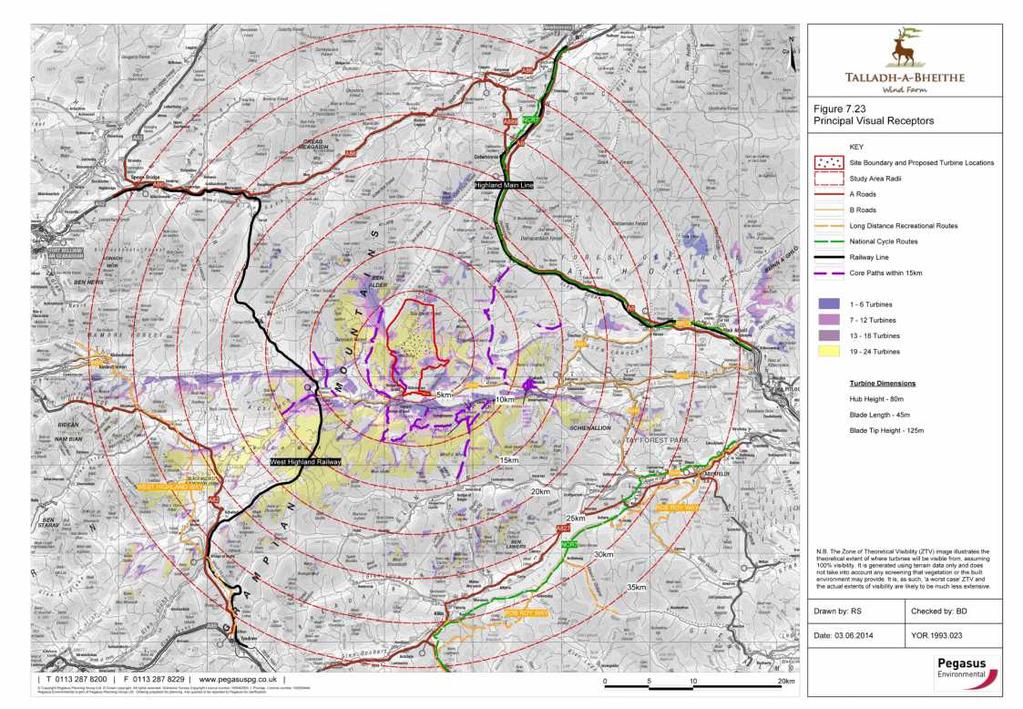
3 Rannoch s Key Landscape Objections A turbine array on this site would be substantially visible and intrusive for c15km of the West Highland Line approaching Rannoch Station. No other windfarm is visible from that line (Figs ); It would dominate views from the core footpath from Rannoch north to the Ben Alder group of hills and would be intrusive from other footpaths south to Glen Lyon and west to Glencoe (Fig 7.23); It would be unacceptably intrusive from the small viewpoint hills immediately south of Loch Ericht, degrading the finest views up the Loch with its wild land surroundings (pages 4,7 and 8 here); The site is inclined towards, below, and within 5km direct vision of the tops and east slopes of the unspoilt Beinn Pharlagain to Sgor Gaibhre and Sgor Choinnich Ridge (pages 14 and 15 here); The site would be in plain view from the southern access routes up Ben Alder via Bealach Breabag, Sgairneach Mhor and the south ridge, remote, wild and deeply cherished (page 11); The turbines would dominate views from the south rim of Ben Alder s summit plateau, as shown in the underlying photograph which is centred on the proposed site as it is (page 12); and the proposed site is a known hunting area for eagles and other protected raptors which overfly it from nearby nests. Protected mammals include otter and pine marten. 3

4 From Meall an Uilit Riabhaich NN looking NE. Camera Canon 5D MkIII, 50mm (standard) lens. Site is to right of plantation on far bank, Loch Ericht and Beinn Bheoil of Alder Group to left. All turbines would be fully visible from this viewpoint on the slopes to the right of this photograph. 4

5 From Meall an Uilit Riabhaich NN looking ENE. Canon 5D MkIII, mm 135mm. The proposed turbines would be on the right slopes of the shallow valley in this photograph and all fully visible from this viewpoint. 5
6 From Dun Daimh NN looking NW. Camera Canon 5D MkIII, 17-40mm L Showing the Beinn Pharlagain Sgor Gaibhre Sgor Choinnich Ridge which directly overlooks the site. 6

7 From Dun Daimh NN looking NE. Camera Canon 5D MkIII, 17-40mm L Site to right of plantation on far bank, on slopes facing towards Loch Ericht and Alder Group on left 7

8 From end of estate vehicle track NN looking ESE. Canon 5D MkIII, mm L Site beyond and to right of trees on far bank. All turbines would be visible (some partly so) from this viewpoint and would dominate the approaches to Ben Alder. 8

9 From footbridge on access path NN looking E of S. Canon 5D MkIII, 17-40mm L Site beyond and above trees on far bank. We estimate that six turbines would be visible from this point. 9

10 Above Ben Alder Bothy, NN Canon 5D MkIII, mm L 70mm. We estimate that turbines 1 and 6 would be visible in the gap in the middle distance. 10

11 From Ben Alder, NN looking E of S. Canon 5D MkIII, 17-40mm L The proposed site is indicated and would dominate the southern approaches to Ben Alder. 11
12 From Ben Alder, NN looking E of S. Canon 5D MkIII, mm L The site is to left of the plantation, on the facing slopes in the middle distance. 12

13 From Bealach Leathann NN looking S of E. Canon 5D MkIII, 50mm (standard) lens. The site is beyond and to right of the plantation, on the facing slopes in the distance. All turbines would be fully visible from here. 13
.")
14 From Leachd Dhubh on Beinn Pharlagain, NN , looking E. Canon 5D MkIII, 50mm (standard) lens. The site is in full view beyond and to right of the plantation, on the sunny NW facing slopes (Schiehallion in the distance). All turbines would be visible from here. 14
.")
15 From Meall Mor on Beinn Pharlagain, NN , looking due E. Canon 5D MkIII, 50mm (standard) lens. The site is in full view beyond and to right of the plantation, on the NW facing slopes (Schiehallion in the right distance). All turbines would be visible from here. 15


16 16 Mapping of Viewpoints (correspond to page numbers)
17 17
18 Current National Planning Policy and Windfarms The current planning policies against which this scheme will be assessed are the Scottish Government s National Planning Framework 3 (NPF3), Scottish Planning Policy (SPP) and the Scottish Natural Heritage (SNH) Wild Land Areas Map, published on 23 June The introduction by the planning Minister stated inter alia that NPF3 and SPP place a ban on windfarm development in the 19 per cent of Scotland identified as National Parks and National Scenic Areas. Significant protection is provided to sensitive areas of land identified within Scottish Natural Heritage s Wild Land Areas Map 2014 SPP identifies (Table 1: Spatial Frameworks at page 39) two levels of areas protected from windfarms: Group 1: Areas where wind farms will not be acceptable - National Parks and National Scenic Areas; and Group 2: Areas of significant protection including areas of wild land as shown on the 2014 SNH map and areas of carbon rich soils, deep peat and priority peatland habitat. Recognising the need for significant protection, in these areas wind farms may be appropriate in some circumstances. Further consideration will be required to demonstrate that any significant effects on the qualities of these areas can be substantially overcome by siting, design or other mitigation. SPP (para 200, p 47) advises planning authorities: Wild land character is displayed in some of Scotland's remoter upland, mountain and coastal areas, which are very sensitive to any form of intrusive human activity and have little or no capacity to accept new development. Plans should identify and safeguard the character of areas of wild land as identified on the 2014 SNH map of wild land areas. 18
19 Incompatibilities of this Scheme with National Planning Policy 1. The proposed site is within an Area of Wild Land as identified by SNH and it is submitted that its long-recognised landscape qualities of remoteness and semi-wilderness would be significantly and adversely affected by this scheme. 2. The topography of the proposed site, sloping evenly towards Loch Ericht and prominent from the footpaths on its shore and the Beinn Pharlagain-to-Ben Alder ridge, could not allow any significant mitigation of its visual impacts on wild land. 3. The site should be assessed as priority peatland habitat inter alia as a known hunting ground for eagles which nest close nearby and for other protected raptors including harriers, peregrine, merlins and kestrels. This valley, adjacent to higher ground, provides the mosaic of land types needed and used by these and other avian species including red and blackthroated divers, moorland waders, grouse and ospreys - which nest in the forestry plantations and overfly to hunt in local lochs. 4. The site is known to have otters in its burns and pine martens in adjacent forestry, both species which are sensitive to disturbance. 5. The proposed scheme would require groundworks and re-alignment of hill tracks in a National Scenic Area in order to achieve access to the site. There would be wide visual intrusion throughout Tay Forest NSA from infrastructure as well as turbines. 19
20 Landscape: Grounds for Rejection 1. Rannoch s wild landscapes and outdoor activities are its core attractions for residents and visitors. Landscape assessments of Rannoch and Strath Ericht by dispassionate professionals (including those of SNH and MCS cited at page 2) have long attested to its rare qualities; 2. A turbine array on this site would be substantially visible and intrusive for c15km of the West Highland Line on the approaches to Rannoch. No existing windfarm is visible from that line; 3. The windfarm would be intrusive from Rannoch s footpaths to Ericht, Glen Lyon and Glencoe and especially so from the approaches to Ben Alder by the loch shore or the western hill ridge; 4. The topography allows virtually no possibility to screen the turbines or mitigate their discordant impacts on the wild landscapes to the west of the site, even from lower land or the railway; 5. The scheme appears to us incompatible with the key principles of the new planning framework of NPF3, SPP and Wild land Mapping. We ask that this planning application is refused on the grounds of the damage it would cause to the rare landscape beauty and wildness of this remote area. If any areas are very sensitive to any form of intrusive human activity and have little or no capacity to accept new development this should qualify. It is A Site Too Far. 20
1.1.1 Landscape character This is the upper part of a bowl-shaped landform, extending east from the Rothiemurchus character area, contained by the
 1.1 Glen More 1.1.1 Landscape character This is the upper part of a bowl-shaped landform, extending east from the Rothiemurchus character area, contained by the arc of the high granite pluton of the Cairngorms
Description of Wild Land Area Loch Etive Mountains Wild Land Area
 9 Loch Etive Mountains Wild Land Area 1 Context This large (507 km 2 ) wild land area (WLA) spans the Lochaber and Argyll border, extending between Taynuilt in the west and Bridge of Orchy and Glen Coe
Descriptions of Wild Land Areas Ben Lui Wild Land Area
 06 Ben Lui Wild Land Area 1 Context The western half of this relatively small WLA lies within Argyll and Bute and the eastern half is in Stirling. It has an area of 145 km 2 and is roughly rectangular
Descriptions of Wild Land Areas Ben More Ben Ledi Wild Land Area
 07 Ben More Ben Ledi Wild Land Area 1 Context This WLA lies in Stirling and wholly within Loch Lomond and the Trossachs National Park. It has an area of 212 km 2 and takes the form of an elongated letter
Description of Wild Land Area Ben More, Mull Wild Land Area
 08 Description of Wild Land Area 2015 Ben More, Mull Wild Land Area 1 Context This relatively small WLA (area of 87 km 2 ), one of 11 island WLAs, is located in the mountainous heart of the Inner Hebridean
SECTION ONE. Scotland s National Parks and National Nature Reserves Ten Things You Might Not Know
 SECTION ONE Scotland s National Parks and National Nature Reserves Ten Things You Might Not Know 5 Ten Things You Might Not Know... 1. SCOTLAND S NATIONAL PARKS AND NATIONAL NATURE RESERVES ARE BEAUTIFUL,
Barra Wood, Perthshire - Just over 11 acres, 69,000
 Barra Wood, Perthshire - Just over 11 acres, 69,000 Barra Wood is a truly spectacular woodland that would make a perfect retreat from the stresses of modern day life. Close to the entance of the wood and
CAIRNGORMS NATIONAL PARK AUTHORITY
 CAIRNGORMS NATIONAL PARK AUTHORITY Title: Prepared by: REPORT ON CALLED-IN PLANNING APPLICATION ANDREW TAIT, (PLANNER, DEVELOPMENT CONTROL) DEVELOPMENT PROPOSED: REFERENCE: APPLICANT: FULL PLANNING PERMISSION
Perth and Kinross Council Development Control Committee 27 August 2008 Recommendation by Development Quality Manager
 Perth and Kinross Council Development Control Committee 27 August 2008 Recommendation by Development Quality Manager 5(7) 08/414 Erection of kennels and cattery at Baltree Farm, Hatchbank, Kinross, KY13
Munro Step Challenge Munro step Challenge
 Munro Step Challenge 2018 Munro step Challenge 2018 1 Munro Step Challenge 2018 This September, we re supporting Blood Cancer Awareness Month by inviting you to take on the Munro Step Challenge. A Munro
Loch Rannoch Conservation Association Strategic Development - 5 Year Action Plan
 Loch Rannoch Conservation Association Strategic Development - 5 Year Action Plan Foreword from Chair On behalf of the Loch Rannoch Conservation Association Board I am pleased to promote our 5 Year Action
APPENDIX 3: DESIGNATED SITES IN THE ITDMG AREA
 APPENDIX 3: DESIGNATED SITES IN THE ITDMG AREA INTRODUCTION The Inveraray & Tyndrum DMG area is moderately heavily designated, containing a number of high profile sites of national importance. In total,
Appalachian Mountain Club
 Appalachian Mountain Club January 30, 2013 Groton Planning Board 754 North Groton Road Groton, NH 03241 Re: Re-opened public hearing regarding a request by EDP Renewables (Lessee), EXPX2/MAXAM (Owner)
Perth and Kinross Council Development Management Committee 30 August 2017 Report of Handling by Interim Head of Planning
 Perth and Kinross Council Development Management Committee 30 August 2017 Report of Handling by Interim Head of Planning 5(2)(ii) 17/270 Siting of 12 caravans/chalets, 3 show caravans/chalets and associated
CAIRNGORMS NATIONAL PARK AUTHORITY LOCAL PLAN PUBLIC INQUIRY - LIST OF CORE DOCUMENTS
 CAIRNGORMS NATIONAL PARK AUTHORITY LOCAL PLAN PUBLIC INQUIRY - LIST OF CORE DOCUMENTS SCOTTISH GOVERNMENT PUBLICATIONS CD1.0 Legislation and Policy Statements CD1.1 The Town and Country Planning Act (Scotland)
Draft Strategic Plans for Coillte s eight Business Area Units ( )
") Draft Strategic Plans for Coillte s eight Business Area Units (2011-2015) Response to Public Consultation from Mountaineering Ireland April 2013 1 Introduction Mountaineering Ireland welcomes this opportunity
Draft Strategic Plans for Coillte s eight Business Area Units (2011-2015) Response to Public Consultation from Mountaineering Ireland April 2013 1 Introduction Mountaineering Ireland welcomes this opportunity
Description of Wild Land Area Cape Wrath Wild Land Area
 40 Cape Wrath Wild Land Area 1 Context This Wild Land Area (WLA) extends 226 km 2 across rolling hills and peatland of Sutherland, the most northern mainland WLA and one of only three mainland areas that
Visual and Sensory Aspect
 Updated All Wales LANDMAP Statistics 2017 Visual and Sensory Aspect Final Report for Natural Resources Wales February 2018 Tel: 029 2043 7841 Email: sw@whiteconsultants.co.uk Web: www.whiteconsultants.co.uk
The Sunshine Coast is part of the global community and generates wealth through export, high-value industries and new investment.
 3.2 Strategic intent 3.2.1 Shaping growth an overview In 2031, the Sunshine Coast is renowned for its vibrant economy, ecological values, unique character and strong sense of community. It is Australia
CAIRNGORMS NATIONAL PARK AUTHORITY
 CAIRNGORMS NATIONAL PARK AUTHORITY Title: REPORT ON CALLED-IN PLANNING APPLICATION Prepared by: NEIL STEWART (PLANNING OFFICER, DEVELOPMENT CONTROL) DEVELOPMENT PROPOSED: REFERENCE: APPLICANT: RECONSTRUCTION
The West Highland Way
 Self Guided The West Highland Way View Trip Dates Book Now Trip Grade: Blue 6 Point to Point The West Highland Way The West Highland Way is a classic long distance walk, covering 152 kilometres (95 miles)
Appalachian Mountain Club
 Appalachian Mountain Club June 3, 2013 Town of Alexandria Board of Selectmen 47 Washburn Road Alexandria, NH 03222 Re: Appalachian Mountain Club s comments on EDP Renewables building permit application
Glencoe and the Highlands
 Luxury Walking Glencoe and the Highlands View Trip Dates Book Now Trip Grade: Blue 4 Glencoe and the Highlands If you re looking to combine superb hiking with a touch of luxury, this is the trip for you.
WALKING IN SCOTLAND IN THE FOOTSTEPS OF ROB ROY
 WALKING IN SCOTLAND IN THE FOOTSTEPS OF ROB ROY Arrival times: Glasgow Airport: by 4pm. Edinburgh Airport: by 2pm plus 20.00 transfer charges on arrival. Departure times: Edinburgh Airport: anytime possible.
8am - We leave the vibrant city of Edinburgh via the motorway and head towards our first stop of the day, the historic city of Stirling
 Personal Highlands Experience Limited Tadis House, 455, Whalley New Road, Blackburn, United Kingdom, BB1 4LB Tel: 01254889627 Mobile: 07858137468 1 Day Western Highlands Experience from Edinburgh Loch
ABERDEEN HARBOUR EXPANSION PROJECT November Volume 3: Technical Appendices. Appendix 17-B SLVIA - ABERDEEN GREEN SPACE NETWORK
 ABERDEEN HARBOUR EXPANSION PROJECT November 2015 Volume 3: Technical Appendices Appendix 17B SLVIA ABERDEEN GREEN SPACE NETWORK APPENDIX 17B: SLVIA ABERDEEN GREENSPACE NETWORK 17B SLVIA Aberdeen green
Kirkcaldy Sea Wall Improvements. Non-technical Summary. For illustration purposes only to give an indicative representation of the scheme.
 ENVIRONMENTAL STATEMENT Non-technical Summary For illustration purposes only to give an indicative representation of the scheme. Kirkcaldy Sea Wall Improvements Introduction A concrete sea wall fronts
Alternative 3 Prohibit Road Construction, Reconstruction, and Timber Harvest Except for Stewardship Purposes B Within Inventoried Roadless Areas
 Roadless Area Conservation FEIS Summary Table S-1. Comparison of Key Characteristics and Effects by Prohibition Alternative. The effects summarized in this table A would occur in inventoried roadless areas
Countryside Trails Dunkeld
 R A N G E R S E RV I C E Countryside Trails Dunkeld WELCOME Welcome to this southern end of Atholl Estates. The countryside here is a wonderful blend of lochs, woodland and heather moor. There is a large
THE CATERAN TRAIL Cairngorms National Park, Scotland
 THE CATERAN TRAIL Cairngorms National Park, Scotland Explore the Scottish Highlands in this 4-day trek along the Cateran Trail, as you follow ancient paths through the hills and glens of Perthshire. A
Perth and Kinross Council Development Control Committee 12 December 2012 Report of Handling by Development Quality Manager
 Perth and Kinross Council Development Control Committee 12 December 2012 Report of Handling by Development Quality Manager 4(3)(i) 12/570 Alterations and replacement windows at Milnathort Town Hall, 1
Perth and Kinross Council Development Management Committee 27 March 2013 Report of Handling by Development Quality Manager
 Perth and Kinross Council Development Management Committee 27 March 2013 Report of Handling by Development Quality Manager 4(3)(ii) 13/138 Erection of a Structure for Floral Display in the Public Park,
1 INFORMATION REQUIREMENTS
 1 INFORMATION REQUIREMENTS 1.1 BACKGROUND 2 1.2 WHAT IS THE DISTRICT PLAN 3 1.3 DISTRICT PLAN STRUCTURE 4 1.4 HOW TO USE THE DISTRICT PLAN 5 1.5 STRATEGIC FRAMEWORK 6 Whanganui District Plan (15 January
Designated Sites. Headlines
 Designated Sites Headlines Over 36% of the Sheffield district is covered by sites with European, national or local designation. These offer valuable habitats to wildlife, with some level of protection,
Scotland's Highlands in Autumn Follow the Road Less Traveled
 Scotland's Highlands in Autumn Follow the Road Less Traveled The Highlands of Scotland are renowned for their wild and brooding landscapes. Mists swirl around craggy mountain peaks and into steep-sided
2.0 PARK VISION AND ROLES
 2.0 PARK VISION AND ROLES 2.1 Significance in the Protected Area System Marble Range and Edge Hills provincial parks protect 6.8% of the Pavillion Ranges Ecosection, which is located in the Southern Interior
(Short Listing) DUPUYER ACREAGE, ROCKY MOUNTAN FRONT
 DUPUYER ACREAGE, ROCKY MOUNTAN FRONT") (Short Listing) DUPUYER ACREAGE, ROCKY MOUNTAN FRONT This unique property is located 8½ miles northwest of Dupuyer, Montana and approximately thirty 30 miles northwest of Choteau, Montana. Great Falls
(Short Listing) DUPUYER ACREAGE, ROCKY MOUNTAN FRONT This unique property is located 8½ miles northwest of Dupuyer, Montana and approximately thirty 30 miles northwest of Choteau, Montana. Great Falls
Description of Wild Land Area Kinlochhourne -Knoydart Morar Wild Land Area
 18 Kinlochhourne -Knoydart Morar Wild Land Area 1 Context This very large area, extending 1065 km 2 across Lochalsh and Lochaber, is the fourth most extensive WLA and only narrowly separated from the second
Key. Cotswold Water Park
 Existing Key Nature Sites Core Biodiversity Corridor Proposed Canals Biodiversity Scope The development of the CWP will be orientated towards meeting and exceeding biodiversity targets, making the CWP
The Alpine Flowers of Ben Lawers
 The Alpine Flowers of Ben Lawers Naturetrek Tour Itinerary Outline itinerary Day 1 Day 2/3 Day 4 Arrive Killin Ben Lawers Lochan na Lairige Departs August Focus Plants and general natural history Grading
FOUNDATIONS OF ARCHAEOLOGY A WALK IN VERNDITCH CHASE
 FOUNDATIONS OF ARCHAEOLOGY A WALK IN VERNDITCH CHASE 1. A Tale of two Long Barrows Long barrows were constructed as earthen or drystone mounds with flanking ditches and acted as funerary monuments during
Glen Orchy, Glen Nant and Appin
 ROYAL SCOTTISH FORESTRY SOCIETY 99th ANNUAL EXCURSION Western Region Friday, 10th May - Saturday, 11th May 1996 Glen Orchy, Glen Nant and Appin This year, Members will be resident in the Columba and Royal
Reference: 06/13/0594/F Parish: Fritton & St Olaves Officer: Mrs M Pieterman Expiry Date:
 Schedule of Planning Applications Committee Date: 21 st January 2014 Reference: 06/13/0594/F Parish: Fritton & St Olaves Officer: Mrs M Pieterman Expiry Date: 20-01-2014 Applicant: Proposal: Site: Lord
Strathaird and Torrin Estates Management Plan
 Strathaird and Torrin Estates Management Plan 2014 2019 finalised April 2014 Photo Keith Brame 1 1. Introduction... 3 2. Vision... 3 3. Aims and Objectives... 3 4. Actions... 3 5. Additional information...
Biosphere Reserves of India : Complete Study Notes
 Biosphere Reserves of India : Complete Study Notes Author : Oliveboard Date : April 7, 2017 Biosphere reserves of India form an important topic for the UPSC CSE preparation. This blog post covers all important
FAWCO. Pre-Conference Tour. Scottish Highlands & the Isle of Skye 5 Day Tour. 14 th 18 th March 2019
 FAWCO Pre-Conference Tour Scottish Highlands & the Isle of Skye 5 Day Tour 14 th 18 th March 2019 DAY 1 14 th March Edinburgh Fort Augustus Your guide will meet you this morning at the Dalmahoy, where
Specification for Grip blocking using Peat Dams
 Technical Guidance Note 1 Specification for Grip blocking using Peat Dams 1. Introduction Moorland drains (grips) have been dug across much of the Yorkshire upland peatlands. Many of these grips have become
Introduction to Map 14: Fionn-phort to Caol Ila
 Introduction to Map 4: Fionn-phort to Caol Ila This map section covers some 3.8km of coastline. In the southern and central part of this section the landscape is dominated by open moorland, with scrub
Recreational Carrying Capacity
 9 th Annual Caribbean Sustainable Tourism Conference Recreational Carrying Capacity Graham C Barrow What is Recreational Carrying Capacity? It s not about fixing absolute numbers of visitors/tourists that
English language. National Assessments Reading - Level E (Informative) A Taste of the Highlands. Name. Date. Assessment is for Learning
 A Taste of the Highlands. Name. Date. Assessment is for Learning") National Assessments 5-14 English language Reading - Level E (Informative) A Taste of the Highlands Name. Date. Assessment is for Learning AssessmentID: 000 - TaskID: 000 A Taste of the Highlands For a
National Assessments 5-14 English language Reading - Level E (Informative) A Taste of the Highlands Name. Date. Assessment is for Learning AssessmentID: 000 - TaskID: 000 A Taste of the Highlands For a
Glencoe and Dalness Property Statement
 Property Statement 2016 The National Trust for Scotland for Places of Historic Interest and Natural Beauty is a charity registered in Scotland, Charity Number SC 007410 Contents CONTENTS 2 LIST OF FIGURES,
26 Utah s Patchwork Parkway SCENIC BYWAY CORRIDOR MANAGEMENT PLAN (SR 143)
") Natural Natural Quality applies to those features in the visual environment that are in a relatively undisturbed state. These features predate the arrival of human populations and may include geological
Natural Natural Quality applies to those features in the visual environment that are in a relatively undisturbed state. These features predate the arrival of human populations and may include geological
BEST OF ARGYLL & ISLE OF ARRAN ITINERARY 30 AUGUST - 6 SEPTEMBER 2008
 INTRODUCTION TO THE AREA Argyll BEST OF ARGYLL & ISLE OF ARRAN ITINERARY 30 AUGUST - 6 SEPTEMBER 2008 We will be based in Port Appin near Oban, which makes it possible to give you a taste of the best walking
Tourism Development Plan for Scotland Questionnaire
 Draft National Tourism Development Plan Public Consultation 2013 Tourism Development Plan for Scotland Questionnaire We would like your views on this Plan and, in particular, your comments on opportunities
VARGAS ISLAND PROVINCIAL PARK
 VARGAS ISLAND PROVINCIAL PARK PURPOSE STATEMENT AND ZONING PLAN February 2003 VARGAS ISLAND PROVINCIAL PARK Purpose Statement and Zoning Plan Primary Role The primary role of Vargas Island Park is to protect
Gatwick Airport Limited. Response to Airports Commission Consultation. Appendix. Ian H Flindell & Associates - Ground Noise Report
 Gatwick Airport Limited Response to Airports Commission Consultation Appendix 10 Ian H Flindell & Associates - Ground Noise Report GATWICK AIRPORT Technical Report in response to Airports Commission Consultation
Offers Over 385,000 (Freehold) Kinlochewe Mountain Chalets, Kinlochewe, Achnasheen, Ross-Shire, IV22 2PA
 Kinlochewe Mountain Chalets, Kinlochewe, Achnasheen, Ross-Shire, IV22 2PA") Offers Over 385,000 (Freehold) Kinlochewe Mountain Chalets, Kinlochewe, Achnasheen, Ross-Shire, IV22 2PA Charming holiday lodge business set within the Torridon Mountain Range and on the North Coast 500
Offers Over 385,000 (Freehold) Kinlochewe Mountain Chalets, Kinlochewe, Achnasheen, Ross-Shire, IV22 2PA Charming holiday lodge business set within the Torridon Mountain Range and on the North Coast 500
5.17 STRANDFONTEIN (permanent population: + 110) (IDP )
 (IDP )") page 305 5.17 STRANDFONTEIN (permanent population: + 110) (IDP 2012-2017) 5.17.1 SPATIAL ANALYSIS, see Figures 5.17.1 Sub-regional location On the West Coast, approximately 8kms north of Doringbaai and
page 305 5.17 STRANDFONTEIN (permanent population: + 110) (IDP 2012-2017) 5.17.1 SPATIAL ANALYSIS, see Figures 5.17.1 Sub-regional location On the West Coast, approximately 8kms north of Doringbaai and
EUROPEAN WALKING HOLIDAYS 2018
 EUROPEAN WALKING HOLIDAYS 2018 SCOTLAND GLEN COE & THE WESTERN HIGHLANDS 8-day / 7-night Classic one-hotel centre-based guided walks beneath the majestic Ben Nevis This remote and spectacular region of
Washakie Wilderness Ranch
 Washakie Wilderness Ranch Dubois, Wyoming Fly Fishing Hunting Ranching Conservation Washakie Wilderness Ranch Dubois, Wyoming Introduction: A stunning 160-acre parcel located at the base of the Ramshorn
Connie Rudd Superintendent, Black Canyon of the Gunnison National Park
 National Park Service U.S. Department of the Interior Black Canyon of the Gunnison National Park and Curecanti National Recreation Area Information Brochure #1 Wilderness and Backcountry Management Plan
1 Introduction. Introduction. Environmental Context. Environmental Sensitivity. Site Location and Surroundings
 Inverclyde Wind Farm Inverclyde Renewables LLP 1 Introduction Introduction 1.1 This (ES) is submitted in support of a full planning application made by Inverclyde Renewables LLP ( the Applicant ) for permission
Survey of Deadwater Fell and Peel Fell
 4 December 2014 Survey of Deadwater Fell and Peel Fell Team: John Barnard, Chris Crocker, Richard Cooper and Graham Jackson 1) Introduction Deadwater Fell (Hill 3542, Section 33, OS 1:50000 Map 80, OS
NATURAL HERITAGE ZONES: A NATIONAL ASSESSMENT OF SCOTLAND S LANDSCAPES
 NATURAL HERITAGE ZONES: A NATIONAL ASSESSMENT OF SCOTLAND S LANDSCAPES Contents Purpose of document 6 An introduction to landscape 7 The role of SNH 7 Landscape assessment 8 PART 1 OVERVIEW OF SCOTLAND'S
Stainforth & Keadby Canal Installation of Multiuser Path
 Stainforth & Keadby Canal Installation of Multiuser Path Introduction North Lincolnshire Council has entered into an agreement with Canal & River Trust to develop proposals to introduce a multiuser path
BALCHRAGGAN CROFT ABRIACHAN, INVERNESS
 BALCHRAGGAN CROFT ABRIACHAN, INVERNESS BALCHRAGGAN CROFT, ABRIACHAN, INVERNESS IV3 8LB A comfortable and spacious family home overlooking Loch Ness. Inverness 10 miles Drumnadrochit 7 miles Airport 19
USDA Trails Strategy WRI: ENGLISH PEAK SURVEY. Theodore Mendoza San Diego State University June 6 th 2016 August 18 th Advisor: Sam Commarto
 WRI: ENGLISH PEAK SURVEY Theodore Mendoza San Diego State University June 6 th 2016 August 18 th 2016 Advisor: Sam Commarto Klamath National Forest Submitted: March 21, 2017 Table of Contents Acknowledgements
Jan Lake Representative Area -- Concept Management Plan --
 Jan Lake Representative Area -- Concept Management Plan -- Saskatchewan Environment and Resource Management December, 1999 Saskatchewan s Representative Areas Network Program The government of Saskatchewan,
Road Cycling. View Trip Dates Book Now. Casks and Castles. Trip Grade: Green 2
 Road Cycling Casks and Castles View Trip Dates Book Now Trip Grade: Green 2 Casks and Castles On this relaxed cycling trip to the Cairngorms National Park you will enjoy beautiful cycling on quiet Highland
UNITED KINGDOM - SCOTLAND Ben Nevis Weekend Trek
 UNITED KINGDOM - SCOTLAND Ben Nevis Weekend Trek This is an Open Challenge itinerary; you can take part on the dates shown and raise money for a charity of your choice. Duration: 3 days / 2 nights Trip
Introduction to Map 30: Sgeir Alt Mhic Eoghainn to Ton Loisgte
 Introduction to : Sgeir Alt Mhic Eoghainn to Ton Loisgte This map section covers some 7.8km of coastline. This section takes in the south western facing butt of the Rhinns and includes the villages of
Bla ck Law G rid Co nnection. Study Area. Figure 6.1. West Lothian. North Lanarkshire. South Lanarkshire. 1km from proposed Cable Route
 Bla ck Law G rid Co nnection West Lothian Study rea 1km from proposed Cable Route 2km from proposed OHL Route Local uthority Boundary North Lanarkshire Black Law Windfarm Extension Substation Overhead
The Outer Hebrides and Skye
 Wilderness Walking The Outer Hebrides and Skye View Trip Dates Book Now Trip Grade: Green 2 The Outer Hebrides & Skye Join us on this adventure to some of the wildest bounds of Scotland - the inspiring
SnowdoniaNationalParkAuthority SupplementaryPlanningGuidance: VisitorAccommodation October2012
 SnowdoniaNationalParkAuthority SupplementaryPlanningGuidance: VisitorAccommodation October2012 8 SNOWDONIA NATIONAL PARK AUTHORITY SUPPLEMENTARY PLANNING GUIDANCE: 8 VISITOR ACCOMODATION Contents 1 Introduction...
approve the Rural Asset Management Plan at Annex 1; and
 Rural Land Asset Management Plan Decision Summary 1. This paper seeks the Board s approval of the attached plan for the of SNH s landholding and proposes seeking the Cabinet Secretary s support for our
Recreation Opportunity Spectrum for River Management v
 Recreation Opportunity Spectrum for Management v. 120803 Introduction The following Recreation Opportunity Spectrum (ROS) characterizations and matrices mirror the presentation in the ROS Primer and Field
STUCKIVOULICH TARBET
 STUCKIVOULICH TARBET STUCKIVOULICH, TARBET G83 7DQ Rarely available detached country house close to Loch Lomond with separate converted coach house in about 10 acres. Tarbet 1 mile. Arrochar 3 miles.
SOEC Field Studies Programmes Examples at Belmont Centre
 SOEC Field Studies Programmes Examples at Belmont Centre Belmont Centre is ideally located for intensive, Geography field studies trips. Whether it s a study on sand dune succession or fluvial processes
Sample Itinerary. UK Family Adventure
 Sample Itinerary UK Family Adventure Day by Day Itinerary Day 1 Arrive Penrith Station Day 4-5 Day 7 Day 2-3 Guided hiking Lakes Day 6 Inverness Day 8 Day 4 Scotland s Dramatic West Coast Day 5 Hiking
North York Moors National Park Authority. Director of Planning s Recommendation
 24 March 2011 List Number 8 North York Moors National Park Authority Ryedale District Parish: Hawnby App Num. NYM/2010/0910/FL Proposal: Location: Applicant: Erection of a 6 metre scaffold/telegraph pole,
Consultation on Draft Airports National Policy Statement: new runway capacity and infrastructure at airports in the South East of England
 Tony Kershaw Honorary Secretary County Hall Chichester West Sussex PO19 1RQ Telephone 033022 22543 Website: www.gatcom.org.uk If calling ask for Mrs. Paula Street e-mail: secretary@gatcom.org.uk 22 May
CUMBERNAULD LIVING LANDSCAPE PROJECT UPDATE 3
 CUMBERNAULD LIVING LANDSCAPE PROJECT UPDATE 3 Ian Mackenzie 2 nd October 2013 WHAT IS THE CUMBERNAULD LIVING LANDSCAPE? Cumbernauld Living Landscape aims to enhance, restore and reconnect green areas of
Nevis Landscape Conservation Action Plan January Landscape Conservation Action Plan. Compiled by the Nevis Landscape Partnership
 Landscape Conservation Action Plan Compiled by the Nevis Landscape Partnership January 2014 1 INDEX Executive Summary 8 Acknowledgements 9 1. Introduction 10 1.1 A Partnership Response 10 1.2 A National
Scheme Objective 1: To improve the operation of the A96 and inter-urban connectivity through:
 FAADAG (the Forres Area A96 Dualling Action Group) offers the following feedback to Transport Scotland (and in copy to SWECO), as invited pursuant to the most recent Route options design update issued
The Northwest Highlands
 Open Canoeing The Northwest Highlands View Trip Dates Book Now Trip Grade: Red 8 The Northwest Highlands This challenging wilderness trip explores one of the most pristine natural areas of Scotland. We
Tourism in the proposed National Park. Alan Bailey
 Tourism in the proposed National Park Alan Bailey Speaking from Experience: o Campsite Opened in mid-2012 o 2015: 3,500 visitors new visitors to the Borders o 2016: + 10 % Growth is continuing o Borders
Mearns Castle High School. Geography Department. Glaciated Landscapes
 Mearns Castle High School Geography Department Glaciated Landscapes Lesson One: Location of Glaciated Uplands in the British Isles The Ice Age in Britain began about 1,000,000 years ago and lasted until
Will Huckerby Forest Enterprise Recreation & Communities Manager Julie McMorran Forest Enterprise Recreation Civil Engineer Fiona
 UPAG Site Visit 2017: Ben A an 15 September 2017 Attendees: Will Huckerby Forest Enterprise Recreation & Communities Manager Julie McMorran Forest Enterprise Recreation Civil Engineer Fiona Scottish Natural
Northland Regional Landscape Assessment Worksheet
 Northland Regional Landscape Assessment Worksheet DESCRIPTION AND CHARACTERISATION Component Land Types Northern and eastern dissected ranges; high relief land type Unit name MT TIGER BUSH AND REMNANTS
Mountain Biking. View Trip Dates Book Now. North West Passage. Trip Grade: Blue 6
 Mountain Biking North West Passage View Trip Dates Book Now Trip Grade: Blue 6 North West Passage All Inclusive New for 2019, we ve created a wild mountain bike adventure that will take you through some
Croiscrag LOCH RANNOCH PITLOCHRY PERTH AND KINROSS
 Croiscrag LOCH RANNOCH PITLOCHRY PERTH AND KINROSS Croiscrag L O C H R A N N O C H P I T L O C H RY P E RT H A N D K I N R O S S Traditional Highland lodge in a spectacular lochside setting Entrance vestibule
DUMFRIES AND GALLOWAY Regional Tourism Strategy
 DUMFRIES AND GALLOWAY Regional Tourism Strategy 2016-2020 1 CONTENTS Foreword 3 Tourism in Dumfries and Galloway 4 National Strategic Framework 6 Dumfries and Galloway Strategic Framework 7 Vision, Mission
UK AND SCOTLAND 6 NIGHTS / 7 DAYS. Arrive at London Airport and private transfer from the Airport arranged by us. Check in hotel.
 Registered Office & preferred: 38, New Rajdhani Enclave Mailing address Vikas Marg, Delhi 110092 Head Operations: 216,2 nd Floor, Crystal Shoppers Paradise Junction 24 th &33 rd Road, Opp. KFC Bandra West,
F6. Coastal Ferry Terminal Zone
 F6. Coastal Ferry Terminal Zone F6.1. Zone description The purpose of the Coastal Ferry Terminal Zone is to provide for the integrated and efficient operation and development of ferry terminal facilities.
ANTONINE WALL - DULLATUR
 Property in Care (PIC) ID: PIC172 Designations: Scheduled Monument (SM90017); Taken into State care: 1960 (Guardianship) Last reviewed: 2018 HISTORIC ENVIRONMENT SCOTLAND STATEMENT OF SIGNIFICANCE ANTONINE
Greening Project Status Report: Grand Canyon National Park
 Greening Project Status Report: Grand Canyon National Park Prepared for the Federal Energy Management Program U.S. Department of Energy February 2001 iii Contents Page 1. Introduction... 1 2. Context of
2.0 Physical Characteristics
 _ 2.0 Physical Characteristics 2.1 Existing Land Use for the Project The site is comprised of approximately 114 acres bounded by Highway 101 to the north, the existing town of Los Alamos to the east, State
Councillor Briefing on Elvetham Chase
 Councillor Briefing on Elvetham Chase In partnership with the Calthorpe Estate, Wates Developments vision for Elvetham Chase is to provide an outstanding new community for Hart District that will become
1. Part of Constantinople with point of Serail, seen from Pera (Melling s Panorama 24, 1819)
") Presentation of historic prospects, panoramas and view points by Melling (1819), photo documentation and digital simulations from 2006 Astrid Debold-Kritter This research on the historic urban metropolitan
Presentation of historic prospects, panoramas and view points by Melling (1819), photo documentation and digital simulations from 2006 Astrid Debold-Kritter This research on the historic urban metropolitan
RESPONSE TO AIRPORT EXPANSION CONSULTATION 27 MARCH 2018 Submitted online by Helen Monger, Director
 RESPONSE TO AIRPORT EXPANSION CONSULTATION 27 MARCH 2018 Submitted online by Helen Monger, Director 1. Expanding Heathrow The expansion of Heathrow will be one of the largest infrastructure projects in