1. Sonoran (19 Languages) of
|
|
|
- Ashlie Carr
- 5 years ago
- Views:
Transcription

1 By John P. Schmal 1
 of northeastern México (Mayo, Opata, Yaqui, Cora, Huichol, Tarahumara & Tepehuán groups in Sonora, Sinaloa, Nayarit, Chihuahua and Durango) 2.")
2 Northern Uto-Aztecan (13 Languages) primarily U.S.-based (Hopi, Comanche & Paiute Southern Uto-Aztecan (48 Languages) of México: 1. Sonoran (19 Languages) of northeastern México (Mayo, Opata, Yaqui, Cora, Huichol, Tarahumara & Tepehuán groups in Sonora, Sinaloa, Nayarit, Chihuahua and Durango) 2. Aztecan/Náhuatl (29 Languages) These languages are spread through many states of México, in particular the central and eastern sections. Lewis, M. Paul (ed.), Ethnologue: Languages of the World, Sixteenth edition. Dallas, Texas: SIL International. Online version: 2
.")

3 Nueva Galicia and Nueva Vizcaya were north of the area that made up the Aztec Empire (which was conquered by the Spaniards in 1521). The Aztecs had no military influence in these northern areas before 1521, but they did have trading relationships with some of the indigenous groups. Source: University of California at Irvine: 3


4 4


5 Source: 5.html 5


6 6


7 7

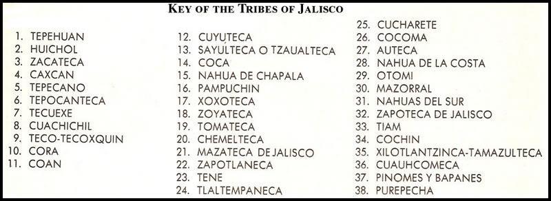
8 The Spanish province of Nueva Galicia embraced 180,000 kilometers and included most of present-day Jalisco, Nayarit, Aguascalientes and Zacatecas. Across this broad range of territory, a wide array of indigenous groups lived during the Sixteenth Century. Domingo Lázaro de Arregui, in his Descripción de la Nueva Galicia - published in wrote that 72 languages were spoken in the Spanish colonial province of Nueva Galicia. Source: Domingo Lázaro de Arregui, Descripción de la Nueva Galicia (Dec. 24, 1621). 8

9 As the Spaniards and their Amerindian allies from the south made their way into Nueva Galicia early in the Sixteenth Century, they encountered large numbers of nomadic Indians. They referred to these natives as the CHICHIMECAS. This was a derogatory term. Utilizing the Náhuatl terms for dog (chichi) and rope (mecatl), the Aztecs referred to the Chichimecas as being of dog lineage (or those who follow dogs as in the descendants of dogs). Source: Philip Wayne Powell, "Soldiers, Indians and Silver: North America's First Frontier War." Tempe, Arizona: Center for Latin American Studies,

 and part of the Uto-Aztecan Stock. Source: Cultural Chichimeca, Online: http://diversidadculturaldibarra.")
10 Chichimecas was the collective name for a wide range of indigenous groups living throughout Zacatecas, Aguascalientes, Durango, parts of Jalisco and many parts of Guanajuato. We will discuss the individual tribes below. It is believed that most of these groups spoke languages that were related to Náhuatl (the language of the Aztecs and Mexica) and part of the Uto-Aztecan Stock. Source: Cultural Chichimeca, Online: 10


11 Source: Wikipedia, Chichimeca War. 11
 The Mixtõn Rebellion (1540-1542). 4) The Chichimeca War (1550-1590).")
12 1) The occupation and conquests of Nuño de Guzmán 2) The influence of epidemics played a significant role in reducing the indigenous populations (especially in western Jalisco). 3) The Mixtõn Rebellion ( ). 4) The Chichimeca War ( ). 5) The gradual assimilation that resulted from the peace by purchase policy of the Marqués de Villamanrique who offered the Chichimecas incentives for peaceful settlement (conversion, food, clothing, lands and agricultural implements). 12

13 The name "Jalisco" is believed to be derived from the Nahuatl words "xalli" (sand, gravel) and "ixtli," which means "face," or by extension, plane. Thus, the word Jalisco would literally mean "sandy place." The first inhabitants of Jalisco were nomadic tribes traveling through the area en route to the south. At one point, the Toltecs ruled over the Kingdom of Xalisco. But, in 1112, the Indian subjects of this kingdom rose in rebellion, leading to the disintegration of Xalisco. 13

14 December 1529: The President of the First Audiencia in Nueva España (Mexico), Nuño Beltrán de Guzmán, left Mexico City with a force of 300 Spaniards and 6,000 Indian allies. Guzmán, a lawyer by profession, had already gained a reputation as a ruthless and cruel administrator when he served as Governor of Panuco on the Gulf Coast In 1531, Guzmán left a trail of devastation and terror through Michoacán, Guanajuato, Jalisco, and Sinaloa. In 1531, Guzmán ordered his chief lieutenant, Juan de Oñate, to found La Villa de Guadalajara on the plateau near Nochistlán in the present-day state of Zacatecas. The construction of Guadalajara began on January 5, However, the small settlement came under repeated attacks almost immediately from the local Cazcanes Indians and, on August 5, 1533, had to be abandoned. The town of Guadalajara would be moved four times before finding its final home on February 14, 1542 at its present site. 14

15 Reports of Guzmán s brutal treatment of the Indians reached the Antonio de Mendoza, who in 1535 was appointed as the first of sixty-one viceroys who would rule Nueva España. In 1536, Mendoza arrested Guzmán in 1536 and imprisoned him. He was returned to Spain where he died in obscurity and disgrace. The long-range implications of Guzmán's reign of terror were realized in 1540 when the Mixtón Rebellion pitted the indigenous people of Jalisco against Spanish rule. Under the leadership of Tenamaxtli, the Indians fortified their positions near Mixtón, Nochistlán, and other towns, while laying siege to Guadalajara. Cristóbal de Oñate, the Acting Governor of the region, pleaded for aid from Viceroy Mendoza. The famous conquistador, Pedro de Alvarado, coming to the aid of Oñate, led an attack on Nochistlán. However, the indigenous defenders counterattacked with such ferocity that Alvarado's forces were routed. In this hasty retreat, a horse fell upon Pedro de Alvarado. Mortally wounded by the crushing weight of the horse, Alvarado, the conqueror of Guatemala, died in Guadalajara a week later on June 24,
 was a leader of the Caxcan Indians")


16 A native of Nochiztlán, Francisco Tenamaztle (also Tenamaxtlan or Tenamaxtli) was a leader of the Caxcan Indians during the Mixton War. He was later put on trial in Spain. With the support of Bartolomé de las Casas, he defended the justice of his cause by appealing to King Carlos I. Sources: Wikipedia, Francisco Tenamaztle; 16

17 Viceroy Mendoza, with a force of 300 horsemen, 300 infantry, eight pieces of artillery and 20,000 Tlaxcalan and Aztec Indian allies, succeeded in recapturing one town after another, against great resistance. By December 8, 1541, most of the indigenous resistance had ended. In 1548, King Carlos V of Spain decreed the creation of the Audiencia of Nueva Galicia, which included all of present-day Jalisco, Zacatecas, and Aguascalientes. In 1550, the Chichimeca War started. Although Zacatecas, Aguascalientes, and Guanajuato were the primary battlegrounds in this fierce frontier war, some parts of Jalisco also came under attack. In 1554, the worst disaster of all took place when Chichimeca Indians attacked a Spanish caravan of sixty wagons with an armed escort in the Ojuelos Pass. In addition to inflicting great loss of life, the Chichimecas carried off more than 30,000 pesos worth of clothing, silver, and other valuables. 17

18 For several decades, the Zacatecos and Guachichile Indians waged a fierce guerrilla war, staging attacks on both mining towns and the small caravans entering the war zone. However, in 1585, Alonso Manrique de Zuñiga, the Marqués de Villamanrique, recently appointed as the Viceroy of Mexico, decided to investigate Spanish policies in the war zone. The Viceroy learned that some Spanish soldiers had begun raiding Indian settlements for the purpose of enslavement. Infuriated by this practice, he prohibited further enslavement of all captured Indians and freed or placed under religious care those who had already been captured. Soon, he launched a fullscale peace offensive and opened up negotiations with the principal Chichimeca leaders. In trade for peace, Villamanrique offered food, clothing, lands, and agricultural implements. This policy of "peace by purchase" worked and by the end of the Sixteenth Century, the Chichimeca War had ended. Source: Powell, Philip Wayne. "Soldiers, Indians and Silver: North America's First Frontier War." Tempe, Arizona: Center for Latin American Studies, Arizona State University,
 and had not possessed most of the luxury items that the Spaniards and their Indian allies had (i.e., warm clothes, agricultural tools and supplies, horses, and beef).")
19 Unable to defeat the Chichimecas militarily in many parts of the war zone, the Spaniards offered goods and opportunities as an incentive for the Zacatecos, Guachichiles and Guamares to make peace. Many of the Chichimecas had been nomadic (or seminomadic) and had not possessed most of the luxury items that the Spaniards and their Indian allies had (i.e., warm clothes, agricultural tools and supplies, horses, and beef). Source: Powell, Philip Wayne. "Soldiers, Indians and Silver: North America's First Frontier War." Tempe, Arizona: Center for Latin American Studies, Arizona State University,

20 The most important component of the "peace by purchase" policy involved the shipment and distribution of food, clothing, and agricultural implements to strategically located depots. The clothing shipped included coarse woolen cloth, coarse blankets, woven petticoats, shirts, hats and capes. The agricultural implements included plows, hoes, axes, hatchets, leather saddles, and slaughtering knives. But the greatest contribution to the pacification process was the vast quantity of food, mostly maize and beef. Another important element of the pacification was the maintenance of freedom. Many of the Indians had been granted exemption from forced service and tribute and had thus retained their independence of action. In most cases, Christian Indians from the south (especially Tlaxcalans) settled among the Chichimecas to help them adapt to their new existence. Source: Powell, Philip Wayne. "Soldiers, Indians and Silver: North America's First Frontier War." Tempe, Arizona: Center for Latin American Studies, Arizona State University,

21 In the meantime, Catholic missionaries had began a vigorous campaign to win the hearts and souls of the native people of Zacatecas. By 1596, fourteen monasteries dotted the present-day area of Zacatecas. The peace offensive and missionary efforts were so successful that within a few years, the Zacatecos and Guachichile Indians had settled down to peaceful living within the small settlements that now dotted the Zacatecas landscape. Working in the fields and mines alongside the Aztec, Tlaxcalan, Otomíe and Tarascan Indians who had also settled in Zacatecas, the Chichimeca Indians were very rapidly assimilated and, as historian Phillip Wayne Powell writes, "the Sixteenth-century land of war thus became fully Mexican in its mixture." Source: Powell, Philip Wayne. "Soldiers, Indians and Silver: North America's First Frontier War." Tempe, Arizona: Center for Latin American Studies, Arizona State University,
. They were never decisively defeated but were bribed into making peace.")
22 Zacatecos Western Zacatecas Guachichiles Eastern Zacatecas Caxcanes Southwest Zacatecas The Caxcanes were pacified in the Mixton Rebellion. The Zacatecos and Guachichiles fought the Spaniards in the Chichimeca War ( ). They were never decisively defeated but were bribed into making peace. Tepehuanes, Huicholes and Tecuexes inhabited some southwestern areas near the borders of Durango, Jalisco and Nayarit. 22


23 The Guachichile Indians were the most populous Chichimeca nation, occupying about 100,000 square kilometers, from Lake Chapala in Jalisco to modern Saltillo in Coahuila. The Guachichiles inhabited all of eastern Zacatecas, portions of eastern Jalisco and some parts of western San Luis Potosí. It is believed that the Guachichile Indians were closely related to the Huichol Indians, who continue to live in Nayarit and the northern fringes of Zacatecas in the present day era Consider the similarity of Guachil and Huichol the theory states that the Huichol were a subgroup that moved to the west and developed their own culture and language. The Hucholes also took great efforts to move to isolated areas to avoid the onslaught of the Spaniards and their indigenous allies. Sources: Allen R. Franz, "Huichol Introduction: The View From Zacatecas," in Stacy B. Schaefer and Peter T. Furst (eds.), "People of the Peyote: Huichol Indian History, Religion, and Survival" (Albuquerque: University of New Mexico Press, 1996); 23
 made of hides and painted red.")
24 The name "Guachichil" was given to them by the Mexica, and meant head colored red (Quaítl = head; Chichitic = red). They had been given this label because they wore red feather headdresses, painted their bodies and their hair red, and wore head coverings (bonetillas) made of hides and painted red. The archaeologist Paul Kirchhoff wrote that the following traits characterized the Guachichile Indians: "painting of the body; coloration of the hair; head gear; matrilocal residence; freedom of the married woman." Source: Paul Kirkchhoff, "The Hunter-Gathering People of North Mexico," in the "North Mexican Frontier: Readings in Archaeology, Ethnohistory, and Ethnography." Carbondale: Southern Illinois University Press,

25 The Spanish frontiersmen and contemporary writers referred to the Guachichiles "as being the most ferocious, the most valiant, and the most elusive" of all their indigenous adversaries. In addition, the Christian missionaries found their language difficult to learn because of its "many sharply variant dialects." As a result, the conversion of these natives to Christianity did not come easy. In the development of tribal alliances, the Guachichiles were considered the most advanced of the Chichimec tribes. They were a major catalyst in provoking the other tribes to resist the Spanish settlement and exploitation of Indian lands. Their attacks on Spanish mines and highways were very effective. Source: Powell, Philip Wayne. "Soldiers, Indians and Silver: North America's First Frontier War." Tempe, Arizona: Center for Latin American Studies, Arizona State University,


26 Presently, the Huichol live primarily in the States of Jalisco and Nayarit. At the time of the 2010 Mexican census, 44,788 people were known to speak this language, which belongs to the Pima-Cora family. The actual number of Huichol is difficult to determine due to the inaccessibility of the mountainous territory in which they live (many peaks over 9000 feet) and the natural suspicion the Huichol have of strangers. The Huichol have protected their traditional culture by removing themselves from areas where non-huichol have come to live. Both men and women wear traditional clothing, with the men s ceremonial clothing being some of the most traditional in Mexico. 26

27 The nation of the Guamares, located in the Guanajuato Sierras, was centered around Penjamo and San Miguel. They extended as far north as San Felipe, and almost to Querétaro in the east. They also extended as far west as Aguascalientes and Lagos de Moreno. The author Gonzalo de las Casas called the Guamares "the bravest, most warlike, treacherous, and destructive of all the Chichimecas, and the most astute (dispuesta)." Some Guamares -- known as IXTLACHICHIMECAS (The Chichimecas Blancos) -- lived in the region between Jalostotitlán and Aguascalientes. This branch of the Guamares painted their heads white. However, much like the Guachichiles, many of the Guamares colored their long hair red and painted the body with various colors (in particular red). 27


28 The Caxcanes Indians occupied portions of present day Aguascalientes, southern Zacatecas and northern Jalisco. They spoke an Uto-Aztecan language. Dr. Phil C. Weigand has theorized that the Caxcan Indians probably originated in the Chalchihuites area of northwestern Zacatecas. After the collapse of the Chalchihuites culture around 900 to 1000 A.D., Dr. Weigand believes that "the Caxcanes began a prolonged period of southern expansion" into parts of Jalisco. Dr. Weigand has further noted that - at the time of the Spanish contact - the Cazcan "were probably organized into small conquest states." He also states that the "overriding theme of their history seems to have been a steady expansion carried by warfare, to the south." 28


29 The Caxcanes Indians occupied portions of present day Aguascalientes, southern Zacatecas and northern Jalisco. They spoke an Uto-Aztecan language. Dr. Phil C. Weigand has theorized that the Caxcan Indians probably originated in the Chalchihuites area of northwestern Zacatecas. After the collapse of the Chalchihuites culture around 900 to 1000 A.D., Dr. Weigand believes that "the Caxcanes began a prolonged period of southern expansion" into parts of Jalisco. Dr. Weigand has further noted that - at the time of the Spanish contact - the Cazcan "were probably organized into small conquest states." He also states that the "overriding theme of their history seems to have been a steady expansion carried by warfare, to the south." 29

30 Dr. Weigand also observed that the Caxcanes "appear to have been organized into highly competitive, expansion states. These states possessed well-developed social hierarchies, monumental architecture, and military brotherhoods." The Caxcanes inhabited a wide area that included Teocaltiche, Tlatenango, Nochistlán and Jalpa. They were frequently at war with the Tecuexes and pushed the latter to the south. 30

31 The Otomíes were another Chichimeca tribe, occupying the greater part of Querétaro and smaller parts of Guanajuato, the northwestern portion of Hidalgo and parts of the state of México. The Otomíes are one of the largest and oldest indigenous groups in Mexico, and include many different groups. Many of the Otomíes aligned themselves with the Spaniards during the Chichimeca War. As a result, wrote Dr. Phillip Wayne Powell, Otomí settlers were "issued a grant of privileges" and were "supplied with tools for breaking land." For their allegiance, they were exempted from tribute and given a certain amount of autonomy in their towns. The Otomíes did not speak an Uto-Aztecan language. 31

32 The semi nomadic Pames constituted a very divergent branch of the extensive Oto-Manguean linguistic family. They were located mainly in the north central and eastern Guanajuato, southeastern San Luis Potosí, and also in adjacent areas of Tamaulipas and Querétaro. To this day, the Pames refer to themselves as "Xi'úi," which means indigenous. This term is used to refer to any person not of mestizo descent. They use the word "Pame" to refer to themselves only when they are speaking Spanish. But in their religion, this word has a contemptuous meaning and they try to avoid using it. 32

33 Cocas Central Jalisco (near Guadalajara) Guachichiles Northeastern Jalisco Huicholes Northwestern Jalisco Tecuexes Northern Jalisco (north of Guadalajara) Caxcanes Northern Jalisco (Los Altos) Tepehuanes Northern Jalisco And many more Disease and war took their toll on these people. The powerful Caxcanes were defeated and humiliated in the Mixtón Rebellion of Today, only the Huicholes survive (mostly in neighboring Nayarit). 33


34 The Tecuexes and Cocas of Jalisco Source: Carolyn Baus de Czitrom, Tecuexes y Cocas: Dos Grupos de la Region Jalisco en el Siglo XVI (1992). 34


35 35

36 36
 live in Nayarit state.")
37 The Cora, or Na'ayarij, people inhabit the rugged mountains and deep canyons of the Sierra del Nayar, which is part of the extensive wide-ranging Sierra Madre Occidental. Most of the 20,078 Coras in Mexico (according to the 2010 census) live in Nayarit state. There are five major Cora communities in in Nayarit - - Santa Teresa, Jesus Maria, San Pedro Ixcatán, San Juan Corapan, and Rosarito Saycota, but some Coras also live in Jalisco. Coras speak a Uto-Aztecan language; together with Huichol the two languages form the Corachol language family. 37

38 Spanish explorers first contacted the Coras in In 1532, Nuño de Guzmán founded Santiago de Compostela (now Tepic). Compostela was the first capital of the Spanish province of Nueva Galicia. However, the conquest of most of Nayarit did not really begin until 1592 when Captain Miguel Caldera entered the Sierra. In 1612, the Cora, Tarahumaras and Tepehuanes all revolted against Spanish rule. But the Cora were not fully taken over until Jesuits and Franciscans eventually established missions in Cora territory and began converting them to Catholicism. In 1857 the Coras were part of an indigenous army that took control of much of Nayarit until the 1870's. The Coras rose up against the government again in during the Cristero Rebellion. 38

39 Nueva Vizcaya (New Biscay) was the first province in the north of Nueva España (New Spain) to be explored and settled by the Spanish. It consisted mostly of the area which is today the states of Chihuahua and Durango. From 1563 to 1565, the explorer Francisco de Ibarra traveled through parts of Nueva Vizcaya, constructing settlements of a permanent nature. It was Ibarra who gave this area its name, after his home province of Vizcaya in Spain. Ibarra founded Durango in 1563, naming it for the Basque town Durango in Biscay, Spain. 39

40 40
. The Chinarra and Chizos were subdivisions of the Choncos in the east. They were subdued in the 1600s.")
41 The Conchos: Named for the Spanish word for shells, the Conchos lived near the junction of the Rio Concho River and Rio Grande Rivers in northern Chihuahua (near present-day towns of Presidio (Texas) and Ojinaga (Chihuahua). The Chinarra and Chizos were subdivisions of the Choncos in the east. They were subdued in the 1600s. The Tobosos: Regarded as a predatory tribe living in the Seventeenth Century in the Bolson de Mapimi and extending northward at least to the Río Grande. They frequently raided Spanish settlements but died out in the 1700s and were replaced by the Apaches. The Jova: This tribe was affiliated with the Opata and were a subdivision of Cahita-Opata-Tarahumar. They occupied the upper part of the valley of the Río Yaqui. Source: William B. Griffen, Indian Assimilation in the Francsican Area of Nueva Vizcaya. Anthropological Papers of the University of Arizona Number 33 (Tucson: The University of Arizona Press, 1979). 41

42 The Jumanos: The name Jumanos was a universal name that sometimes included many different people. They were also called Cibolos and believed to be elated to the Suma Indians. They inhabited the La Junta area along the Río Grande River above the big bend. The Apaches: The word "Apache" comes from the Yuma word for "fighting-men". It also comes from a Zuni word meaning "enemy". The Apaches were diverse bands of huntergatherers related linguistically to the Athapaskan speakers of Alaska and western Canada. The Apaches were composed of six regional groups. Source: William B. Griffen, Indian Assimilation in the Francsican Area of Nueva Vizcaya. Anthropological Papers of the University of Arizona Number 33 (Tucson: The University of Arizona Press, 1979). 42

43 The Tepehuanes occupied an extensive area of the Sierra Madre Mountains from the southern headwaters of the Rio Fuerte to the Rio Grande de Santiago in Jalisco. Much of their territory lay in present-day Durango and southern Chihuahua. The first Jesuits, bearing gifts of seeds, tools, clothing and livestock, went to work among the Tepehuanes in Between 1596 and 1616, eight Jesuit priests had converted the majority of the Tepehuanes. It is likely that the epidemics that struck the Tepehuanes population in 1594, , , and became a catalyst for their great rebellion in

44 According to Charlotte M. Gradie, the author of The Tepehuán Revolt of 1616: Militarism, Evangelism, and Colonialism in Seventeenth-Century Nueva Vizcaya, a combination of famine and disease caused the Tepehuanes culture to undergo "enormous stress from various factors associated with Spanish conquest and colonization." This stress convinced the Tepehuanes to embrace a return to their traditional way of life before the arrival of the Spaniards. On the night of November 16, 1616, the Tepehuán rose in rebellion. Ms. Charlotte M. Gradie writes that "native allies [of the Spaniards] were crucial in mounting an effective defense against the Tepehuanes and in putting down the revolt." On December 19, Captain Gáspar de Alvear led a force of sixty-seven armed cavalry and 120 Concho allies into the war zone to confront the insurgents. 44

45 The hostilities continued until 1620 and laid waste to a large area. When Mateo de Vesga became Governor of Nueva Vizcaya in 1618, he described the province as "destroyed and devastated, almost depopulated of Spaniards." By the end of the revolt, at least a thousand allied Indians had died, while the Tepehuanes may have lost as many as 4,000 warriors. Professor Edward Spicer regards the Tepehuán revolt as "one of the three bloodiest and most destructive Indian attempts to throw off Spanish control in northwestern New Spain." Following the revolt, the Tepehuanes fled to mountain retreats to escape Spanish vengeance. Not until 1723 would the Jesuits return to work among them. 45


46 46


47 The Varohío (Guarijío & Huarijío) live in the Southeast Sonora and Western Chihuahua Sierras. Inhabiting 17 villages, the Guarijío are closely related to and speak a language very similar to the Tarahumara. Guarijios call themselves macurawe or macoragüi, term that means those who hold on to the land or those who walk on the land. 47


48 The Tarahumara Indians of Chihuahua belong to the Uto- Aztecan Linguistic Family. They originally occupied more than 28,000 square miles of mountainous terrain, an area that is even larger than the state of West Virginia. Today, the Tarahumara are a people whose rich spiritual ideology and strong cultural identity have persevered despite the intrusion of foreign customs. The Spanish originally encountered the Tarahumara throughout Chihuahua upon their arrival in the late 1500's, but as the Spanish encroached on their civilization the shy and private Tarahumara gradually retreated to less accessible canyons and valleys in the Sierra Tarahumara. 48

49 Occupying an extensive stretch of the Sierra Madre Mountains, the Tarahumara Indians were ranchería people who planted corn along the ridges of hills and in valleys. During the winters, they retreated to the lowlands or the deep gorges to seek shelter. Some of them lived in cave excavations along cliffs or in stone masonry houses. The Tarahumara received their first visit from a Jesuit missionary in But the ranchería settlement pattern of both the Tepehuanes and Tarahumara represented a serious obstacle to the efforts of the missionaries who sought to concentrate the Amerindian settlements into compact communities close to the missions. The Tarahumara participated in several rebellions. 49
 Tarahumares - Western and Eastern Durango; Southern Chihuahua (1621-1622) Revolt of the Tobosos, Salineros and Conchos - Eastern and Northwestern Durango; Southern Chihuahua (1644-1652)")
50 Acaxee Revolt - Northwestern Durango and East Central Sinaloa (1601) Xiximes Revolt - Northwestern and western Durango (1610) Tepehuanes Revolt - Western and Northwestern Durango, Southern Chihuahua ( ) Tarahumares - Western and Eastern Durango; Southern Chihuahua ( ) Revolt of the Tobosos, Salineros and Conchos - Eastern and Northwestern Durango; Southern Chihuahua ( ) Revolt of the Tarahumara ( ) 50
 Comanche Raids into Chihuahua and Durango (Second Half of the Eighteenth Century) War with the Comanche")
51 Revolt of the Salineros, Conchos, Tobosos, and Tarahumares - Northeastern Durango; Southern and Western Chihuahua ( ) The Great Northern Revolt of the Pueblos, Salineros, Conchos, Tobosos and Tarahumares - New Mexico, Northeastern Durango, Southern and Western Chihuahua ( ) Comanche Raids into Chihuahua and Durango (Second Half of the Eighteenth Century) War with the Comanche Indians s Confrontations with Comanches - Sonora, Chihuahua and Durango ( ) 51


52 52
 Pápagos: Northwest Sonora near the U.S. border (Caborca, Magdalena y Sonoyta) Pimas: living in Ures and Saharipa (Pimería Alta), San Ignacio (Pimería Baja) Guarijíos: Southeast Sonora (the municipios of Álamos and Quiriego).")
53 Mayos: Southeast (the municipios of Etchojoa, Navojoa, Huatabampo, Quiriego y Álamos) Yaquis: Southern Sonora (in the Valle del Yaqui and municipios of Guaymas, Hermosillo, Bácum, Cajeme y Empalme) Seris: Central and Northwest (around el Desemboque, Punta Checa y Hermosillo) Pápagos: Northwest Sonora near the U.S. border (Caborca, Magdalena y Sonoyta) Pimas: living in Ures and Saharipa (Pimería Alta), San Ignacio (Pimería Baja) Guarijíos: Southeast Sonora (the municipios of Álamos and Quiriego). Source: Etnias de Sonora: Indígenas de Sonora (2010): Online: 53


54 The indigenous people confronted by Guzmán belonged to the Cáhita language group. Speaking eighteen closely related dialects, the Cáhita peoples of Sinaloa and Sonora numbered about 115,000 and were the most numerous of any single language group in northern Mexico. These Indians inhabited the coastal area of northwestern Mexico along the lower courses of the Sinaloa, Fuerte, Mayo, and Yaqui Rivers. The most well-known Cáhita tribe was the Yaqui Indians. From 1740 to 1927, the Yaquis were frequently at war with the Spanish Empire and the Mexican Government. They have been both admired and feared for their resistance. 54

55 When Guzmán arrived in northern Sinaloa and southern Sonora, he found indigenous groups that belonged to the Cáhita language group. Speaking eighteen closely related dialects, the Cáhita peoples of Sinaloa and Sonora numbered about 115,000 and were the most numerous of any single language group in northern Mexico. These Indians inhabited the coastal area of northwestern Mexico along the lower courses of the Sinaloa, Fuerte, Mayo, and Yaqui Rivers. Cahita are a Uto-Aztecan tribe of the Taracahitian family that lived in southwestern Sonora and northwestern Sinaloa, primarily in the middle and lower portions of the Rio Yaqui, Rio Mayo, Rio Fuerte and Rio Sinaloa valleys and extending to the Sierra Madre, except for a coastal tract south of the Estero de Agiabampo. The Cahitan group was divided into the following primary groups: 1. Bamoa (on th(south of Rio Sinaloa) 2. Sinaloa e upper Rio Fuerte) 3. Mayo (on the Rio Mayo) 4. Tehueco (on the Rio Oteros) 5. Yaqui (on Rio Yaqui) 6. Zuaque (on the lower course of the Rio Fuerte). 55

56 Year (s) Even t 1531 Guzman fights the Cáhita speakers (Sinaloa & Sonora) Hurdaide s Offensive in Sinaloa Spaniards make contact with Mayo and Yaquis The Mayos and Yaquis are converted to Christianity The Yaqui, Pima and Mayo Indians revolt The Pima of Sonora rebel against the Spaniards Apaches attack both Sonora and Chihuahua The Seris battle the Spaniards in Sonora The Jesuits are banished from Mexico The Yaqui, Mayo and Opata rebel in Sonora & Sinaloa against the newly independent Mexican Government The Yaqui leader Banderas forms an alliance with the Opatas and wages war on the Mexican army. Banderas is captured in Dec 1832 and executed in 1833, along with other Yaquis, Mayo and Opata leaders. 56

57 Year (s) Even t The Yaquis rebel against 1867 Governor Pesqueira of Sonora sends military expeditions under the command of Gen. Jesus Garcia Morales against the Yaquis. The Yaquis were pacified after a ruthless campaign Intermittent Yaqui resistance took place A Yaqui and a veteran of the Mexican army name Cajeme begins a new Yaqui resistance by demanding selfgovernment for the Yaquis Mexican President Porfirio Diaz and the Sonora Government wage continuous war against the Yaquis 1901 The Yaqui rebel leader Tetabiate is betrayed and murdered Some Yaquis are rounded up and deported to the Yucatan. Between 8 and 15,000 of the 30,000 Yaquis are allegedly deported during this period. 57
. Mexican Federal Troops captured 415 Yaquis, including 214 women and 175 children.")
58 Year (s) Even t 1905 A government study cited 270 instances of Yaqui and Mayo warfare between 1529 and 1902, excluding eighty-five years of relative peace between 1740 and The Yaquis fight their last major battle at Cerro del Gallo (Hill of the Rooster). Mexican Federal Troops captured 415 Yaquis, including 214 women and 175 children Mexican President Cárdenas, proud of his Indian blood, serves notice that his government would provide extensive benefits for the Yaquis. In 1937, Cardenas signs a treaty that creates the Yaqui Zona Indígena, which included approximately half of the territory that the Yaquis had claimed as their traditional homeland. 58


59 59
 Source: INEGI, Censo de Población y Vivienda, 2010.")
60 Rank Indigenous Language 7 Otomíes 284, Purépecha 124, Tarahumara 85, Huichol 44, Cora 20, Yaquis 17, Tepehuanes 35,873 Number of Inhabitants Speaking Language in all of Mexico (2010) Source: INEGI, Censo de Población y Vivienda,

61 Indigenous Language Number of Inhabitants Speaking Language in 2010 Huichol 1,003 Náhuatl 503 Tepehuano 492 Tlapaneco 381 Source: INEGI, Censo de Población y Vivienda,

62 Indigenous Language Number of Inhabitants Speaking Language in 2010 Huichol 25,151 Cora 20,793 Tepehuano 1,972 Náhuatl 1,904 Source: INEGI, Censo de Población y Vivienda, Note: The 49,963 indigenous speakers in the State of Nayarit represent 5% of the total state population 5 years of age and older. 62

63 Indigenous Language Number of Inhabitants Speaking Language in 2010 Huichol 18,409 Náhuatl 11,650 Purépecha 3,960 Mixtecas Speakers 2,001 Source: INEGI, Censo de Población y Vivienda, Note: The 51,702 indigenous speakers in the State of Jalisco represent only 1% of the total state population 5 years of age and older. 63

64 Indigenous Language Number of Inhabitants Speaking Language in 2010 Tepehuano 26,453 Huichol 2,038 Náhuatl 1,124 Tarahumara 558 Source: INEGI, Censo de Población y Vivienda, Note: The 30,894 indigenous speakers in the State of Durango represent 2% of the total state population 5 years of age and older. 64

65 Indigenous Language Number of Inhabitants Speaking Language in 2010 Tarahumara 85,316 Tepehuano 8,396 Mixtec Languages 2,500 Náhuatl 1,286 Source: INEGI, Censo de Población y Vivienda, Note: The 104,014 indigenous speakers in the State of Chihuahua represent 3% of the total state population 5 years of age and older. 65

66 To read more about the various indigenous peoples of México, please see: For detailed statistics about the 1921 Mexican census, please see: ustable.html 66
Spanish Missions History and Purpose
 Spanish Missions History and Purpose Columbus's voyage of discovery opened a new world of possibilities for the Spanish. In the Americas, Spain soon began to use its soldiers to increase the size of its
Spanish Colonies on the Borderlands
 Spanish Colonies on the Borderlands Pages 90 93 Nov 1 8:14 PM 1 Today's Objectives *Describe Spain s colony in Florida. *Explain how Spain established settlements throughout much of North America. *Describe
Unit 13: La Entrada The Spanish Enter New Mexico
 Assessment Activities: Student Activity Sheet Activity 1. Matching Place Names Draw a line to connect the Spanish Place Name with its English definition. 1. Los Alamos a. mayor 2. Española b. the stream
Spanish Land Grant History of Santa Teresa and Sunland Park Abridged by Dr. Paul Maxwell Taken from the NM Office of the State Historian
 Spanish Land Grant History of Santa Teresa and Sunland Park Abridged by Dr. Paul Maxwell Taken from the NM Office of the State Historian Introduction: Ownership of what now encompasses the Sunland Park
Chapter 6 The Spanish Colonial Period
 Chapter 6 The Spanish Colonial Period The Spanish had lost interest in Texas after the failed expeditions of the 1500 s. They did build colonies in New Mexico along the upper Rio Grande (remember that
History of the Mexican Revolution
 History of the Mexican Revolution By ThoughtCo.com, adapted by Newsela staff on 10.19.17 Word Count 1,098 Level 840L Revolutionaries Emiliano Zapata and Pancho Villa are among the prominent figures from
Summary Article: Mexico from Philip's Encyclopedia
 Topic Page: Mexico Summary Article: Mexico from Philip's Encyclopedia The United Mexican States is the world's largest Spanish-speaking country. It is largely mountainous. The Sierra Madre Occidental begins
INDIGENOUS MÉXICO: An Introduction to México s Remarkable Diversity
 INDIGENOUS MÉXICO: An Introduction to México s Remarkable Diversity By John P. Schmal Copyright 2008 by John P. Schmal. All rights under applicable law are hereby reserved. Materials from this presentation
The Rise of Rome. After about 800 BC other people also began settling in Italy The two most notable were the and the
 The Rise of Rome The Land and People of Italy Italy is a peninsula extending about miles from north to south and only about 120 miles wide. The mountains form a ridge from north to south down the middle
NEW SPAIN - MEXICO ( )
") NEW SPAIN - MEXICO (1521-1848) The Other Conquest In 1521, the Aztec civilization is conquered by the Spanish and over 75,000 allies. The Spanish call the new land, NUEVA ESPANA The Conquest is devastating:
NEW SPAIN - MEXICO (1521-1848) The Other Conquest In 1521, the Aztec civilization is conquered by the Spanish and over 75,000 allies. The Spanish call the new land, NUEVA ESPANA The Conquest is devastating:
Unit 3: Exploration and Early Colonization (Part 2) Spanish Colonial Era
 Spanish Colonial Era") Unit 3: Exploration and Early Colonization (Part 2) Spanish Colonial Era 1700-1821 For these notes you write the slides with the red titles!!! Goals of the Spanish Mission System To control the borderlands
Unit 3: Exploration and Early Colonization (Part 2) Spanish Colonial Era 1700-1821 For these notes you write the slides with the red titles!!! Goals of the Spanish Mission System To control the borderlands
Economic and Social divisions between the rich and poor in New Spain
 1519-1821 Economic and Social divisions between the rich and poor in New Spain By the early 1800 s, residents of Mexico were tired of being ruled by Spain. Poverty and racism in New Spain were extreme:
Utah Nevada California Arizona New Mexico Baja California Texas Sonora Chihuahua Coahuila de Zaragoza Sinaloa Durango Nuevo León Zacatecas San Luis
 Nevada Utah California Arizona New Mexico Baja California Sonora Texas Chihuahua Coahuila de Zaragoza Sinaloa US States Mexico States International Boundary Durango Nayarit Zacatecas Jalisco Nuevo León
NEW SPAIN - MEXICO ( )
") NEW SPAIN - MEXICO (1521-1848) The Other Conquest In 1521, the Aztec civilization is conquered by the Spanish and over 75,000 allies. The Spanish call the new land, NUEVA ESPANA The Conquest is devastating:
NEW SPAIN - MEXICO (1521-1848) The Other Conquest In 1521, the Aztec civilization is conquered by the Spanish and over 75,000 allies. The Spanish call the new land, NUEVA ESPANA The Conquest is devastating:
In some ways missions were like small towns. They provided for the spiritual and physical needs of the people that lived within their protective
 In some ways missions were like small towns. They provided for the spiritual and physical needs of the people that lived within their protective walls. Since the chief goal of the mission was to convert
Chapter 12 Manifest Destiny ( ) Section 3 War With Mexico
 Section 3 War With Mexico") Assess your agreement with the following statement: The United States government acted morally in its acquisition of the land of the present-day continental United States. A. Strongly agree B. Somewhat
Assess your agreement with the following statement: The United States government acted morally in its acquisition of the land of the present-day continental United States. A. Strongly agree B. Somewhat
Countries Of The World: Mexico
 Countries Of The World: Mexico By National Geographic Kids, adapted by Newsela staff on 06.07.18 Word Count 638 Level 800L Image 1: The pyramids of Guachimontones in Jalisco, Mexico. Mexico is a country
Tucson History Series
 Tucson History Series This is the third of a six-part series on the history of Tucson. Author Bob Ring challenged himself to capture the what, when, and how of the important events that shaped Tucson s
Chapter 3. The Loss of Azlan
 Chapter 3 The Loss of Azlan Objective: Students will be able to identify key events during the fight for Mexican Independence, and identify key people that helped in the fight for Independence. DO NOW:
Our Mission. Santa Fé de Toloca. Alachua County Historic Site. Ellen Goldberg and Ana Robles
 Our Mission Santa Fé de Toloca Alachua County Historic Site Ellen Goldberg and Ana Robles Our Mission After a long day of gathering information and travel to the edge of the county of Alachua we have found
Warm-up. A. Exports only manufactured goods B. Should import fewer products C. Needs to import more products D. Does not import or export
 Warm-up As with any small country, Cuba has fewer natural resources than countries such as Brazil. This affects their trade in that Cuba A. Exports only manufactured goods B. Should import fewer products
The Persian Empire 550 BCE-330 BCE
 The Persian Empire 550 BCE-330 BCE The Rise of Persia The Persians based their empire on tolerance and diplomacy. They relied on a strong military to back up their policies. Ancient Persia is where Iran
Content Statement: Explain how Enlightenment ideals influenced the French Revolution and Latin American wars for independence.
 Reforms, Revolutions, and Chapter War 9.3 Section 3 Independence in Latin America Content Statement: Explain how Enlightenment ideals influenced the French Revolution and Latin American wars for independence.
How Spain Colonized Texas
 How Spain Colonized Texas Brief History 1492 Columbus came to America Spaniards came to explore American mainland 1500s Spanish explorers Cabeza de Vaca and Coronado reinforced Spanish claim to Texas Friars
11/16/15. Today s! Topic: " Latin America Independence Movement
 Classes begin at: 1st Block 8:35am 2 nd Block 10:05am Georgia Cyber Academy s mission is to provide an exemplary individualized and engaging educational experience for all students. Learning Target: I
SANTA ELENA EST. 1566
 SANTA ELENA EST. 1566 450 year-old Spanish town under Parris Island Golf Course Santa Elena was founded by Pedro Menendez de Aviles in April 1566. This date was nearly forty years before the founding of
Exploring Mexico. Directions: Complete the paragraphs below. Write the correct word from the Word Bank to complete each sentence.
 Exploring Mexico Section 1 10 Directions: Complete the paragraphs below. Write the correct word from the Word Bank to complete each sentence. Word Bank United States Central Plateau irrigation isthmus
La Historia de España. A general outline of important events in the history of Spain.
 La Historia de España A general outline of important events in the history of Spain. http://www.timeforkids.com/destination/spain Question? As you learn about Spanish history, reflect upon this question:
Utah Studies DOMINGUEZ AND ESCALANTE
 Utah Studies THE WORLD IN THE 1400 S In the 1400 s merchants in Europe wanted to buy and sell goods with people in faraway places. Some of the reasons for this desire to trade with the world were: the
The Rise of Rome. Chapter 5.1
 The Rise of Rome Chapter 5.1 The Land and the Peoples of Italy Italy is a peninsula about 750 miles long north to south. The run down the middle. Three important fertile plains ideal for farming are along
The Age of Exploration
 The Age of Exploration During the Renaissance period Europe experienced a rebirth in knowledge. One of the results was exploration. The inventions and uses of the caravel, and new type of ship, and sextant,
Lake Chapala Dra. Raquel Gutiérrez Nájera Location 1
 Lake Chapala Dra. Raquel Gutiérrez Nájera Location Administrative Division The hydrological region formed by Lerma and Santiago rivers constitute a natural hydrologic river basin which covers an area of
LATIN AMERICAN INDEPENDENCE MOVEMENTS : An Age of Revolutions
 LATIN AMERICAN INDEPENDENCE MOVEMENTS 1750-1914: An Age of Revolutions BACKGROUND Indigenous peoples and civilizations Maya, Aztec, Inca European Colonization, 1500s Spain, Portugal, France American Revolution,
Regional Economic Report July- September 2014
 Regional Economic Report July- September 2014 December 11, 2014 Outline I. Introduction II. Results July September 2014 A. Economic Activity B. Inflation C. Economic Outlook III. Final Remarks Introduction
Latin American Revolutions
 Latin American Revolutions The term Latin American Revolutions refers to the various revolutions that took place during the early 19th century that resulted in the creation of a number of independent countries
Countries Of The World: Mexico
 Countries Of The World: Mexico By National Geographic Kids, adapted by Newsela staff on 06.07.18 Word Count 659 Level MAX Image 1: The pyramids of Guachimontones in Jalisco, Mexico. Mexico is a country
AP US History: An Essential Coursebook (2nd Ed)
") Unit One: Early Native and Colonial Societies (1491-1754) Chapter One: Pre-Columbian Societies AP US History: An Essential Coursebook (2nd Ed) Environment and Geography How did physical features affect
Unit One: Early Native and Colonial Societies (1491-1754) Chapter One: Pre-Columbian Societies AP US History: An Essential Coursebook (2nd Ed) Environment and Geography How did physical features affect
Analysis of the 2012 Mexican Presidential Elections
 1 Analysis of the 2012 Mexican Presidential Elections Yazmin Valdez, Olmo Zavala, Jorge Zavala, Elena Tai, Melina Ávila, Jorge Barreda, and Daniel Santiago June 2013 2 Abstract Historically, Mexican Presidential
WORLD HISTORY 8 UNIT 2, CH 4.3. The Middle and New Kingdoms PP
 WORLD HISTORY 8 UNIT 2, CH 4.3 The Middle and New Kingdoms PP. 100-104 THE MIDDLE KINGDOM pp. 100-101 1. WHY DID THE WEALTH AND POWER OF THE PHARAOHS DECLINE AT THE END OF THE OLD KINGDOM? The wealth and
Mexican cartel murders photos
 Mexican cartel murders photos The Borg System is 100 % Mexican cartel murders photos Scenes from the violent drug war across the border. The images below have been sent to me over the past year from sources
Essential Question: What is Hellenism? What were the lasting characteristics of the Roman Republic & the Roman Empire?
 Essential Question: What were the lasting characteristics of the Roman Republic & the Roman Empire? Warm-Up Question: What is Hellenism? Why was Alexander of Macedonia considered great? In addition to
Mexico s Early National Period By: Dr. Richard Bruce Winders, Alamo Historian & Curator
 Mexico s Early National Period By: Dr. Richard Bruce Winders, Alamo Historian & Curator For the coming year, The Alamo Messenger will focus on Mexico s Early National Period as a topic of interest. The
SS Grade 7 Unit 04: Spanish Colonial _Edited
 Name: Date: Teacher: SS rade 7 Unit 04: Spanish Colonial 2012-2013_Edited Testing Date: October 24, 2012 Recommended Duration: 1 Class period 1 Which of the following was a characteristic of the Spanish
The Battle of Quebec: 1759
 The Battle of Quebec: 1759 In the spring of 1759, the inhabitants of Quebec watched the river with worried eyes. They waited anxiously to see whether the ships of the French, or those of the British fleet,
Regional Economic Report April June 2012
 Regional Economic Report April June 2012 September 13, 2012 Outline I. Introduction II. Results April - June 2012 A. Economic Activity B. Inflation C. Economic Outlook III. Final Considerations Introduction
North America Geography. Chapter 3 Section 1
 North America Geography Chapter 3 Section 1 Ch 3 Sec 1.1: Physical Geography North America stretches from the cold arctic of northern Canada to the warm tropics of Mexico. At the center of N.A. lie the
Trading Salt for Gold: The Ancient Kingdom of Ghana
 Trading Salt for Gold: The Ancient Kingdom of Ghana By USHistory.org, adapted by Newsela staff on 06.27.17 Word Count 958 Level 1040L A trade caravan traveling in Africa. Ghana played an important role
Chapter 4 Economic Freedom in the United Mexican States
 Chapter 4 Economic Freedom in the United Mexican States by Nathan J. Ashby The effort to provide a measure of economic freedom including all three nations of North America has been hampered by the difficulty
Part 5 War between France and Great Britain
 Part 5 War between France and Great Britain The objects of colonial rivalries PAGE 117 France Wanted to control the fur trade Expand their territory Great Britain Wanted to control the fur trade Expand
Chapter 10: The Kingdom of Kush
 Chapter 10: The Kingdom of Kush Learning Target: I can explain how location influenced the Kingdom of Kush. Introduction The African kingdom of Kush was located on the Nile River, to the south of Egypt.
Latin American Revolutions of the early 1800s
 Latin American Revolutions of the early 1800s I. Background The Spanish/Portuguese Colonial System A. The Roles of Colonies fulfillment of mercantilism for Spain and Portugal 1. Plantation Agriculture
Bay of Pigs Invasion 1961
 Bay of Pigs Invasion 1961 The Bay of Pigs Invasion, Operation Zapata, was an attempt by anticommunist Cuban exiles to overthrow Fidel Castro s Cuban government. This operation began on March 17, 1960,
Part 5 War between France and Great Britain
 Part 5 War between France and Great Britain The objects of colonial rivalries PAGE 111 France Wanted to control the fur trade Expand their territory Great Britain Wanted to control the fur trade Expand
North-East New Mexico September October 2012
 North-East New Mexico September October 2012 Pecos National Historical Park As visitors walk about Pecos National Historical Park in northeastern New Mexico at least three different, though related, histories
AFRICAN CIVILIZATION. The Kushite Kingdom in Upper Egypt and the Sudan
 AFRICAN CIVILIZATION The Kushite Kingdom in Upper Egypt and the Sudan The Kingdom of Kush The civilization of Kush thrived from about 2000 B.C.E. to 350 C.E. Kush and Egypt had a close relationship throughout
Trading Salt for Gold: The Ancient Kingdom of Ghana
 Trading Salt for Gold: The Ancient Kingdom of Ghana By USHistory.org, adapted by Newsela staff on 06.27.17 Word Count 958 Level 1040L A trade caravan traveling in Africa. Ghana played an important role
Taos Pueblo, New Mexico
 Taos Pueblo, New Mexico The Southwest Border Area Precipitation Climates of the US U.S. and Canada The Southwest Border Area A region of three dominating cultures: Native American, Spanish American, and
Guided Notes - Persian & Peloponnesian Wars
 Guided Notes - Persian & Peloponnesian Wars The Persian Wars - 510-478 B.C.E Major Battles: Marathon, Thermopylae, Salamis, & Plataea The Persians: Led by Began creating one of the world s largest empires
JUAN DOMINGUEZ DE MENDOZA
 SUB Hamburg B/119429 JUAN DOMINGUEZ DE MENDOZA SOLDIER AND FRONTIERSMAN OF THE SPANISH SOUTHWEST, 1627 1693 Edited by France V. Scholes Marc Simmons Jose Antonio Esquibel Translated by Eleanor B. Adams
II. Mexico City + Museo de Antropología
 ONE DAY EXCURSIONS I. Mexico City Megalopolis such as Mexico City are formed by the gradual fusion of several cities and towns. The roots of Mexico's capital lie in the so-called Historic Center, an area
Located in southwestern Iran Building an empire Same time Athens was becoming a democracy
 Located in southwestern Iran Building an empire Same time Athens was becoming a democracy Built a strong Persian army Began creating an empire that became the largest in the ancient world Armies took
LESSON 1: The Geography of Greece (read p )
") Name Period Parent Signature Teacher use only Chapter 9 Study Guide: Ancient Greece % MULTIPLE CHOICE: Using your textbook, completed folder activities, and your graded homework assignments, choose the
Name Period Parent Signature Teacher use only Chapter 9 Study Guide: Ancient Greece % MULTIPLE CHOICE: Using your textbook, completed folder activities, and your graded homework assignments, choose the
FROM COLONY TO INDPENDENT NATION
 FROM COLONY TO INDPENDENT NATION Quiz: Wednesday! Aztecs, Incas, Cuban Revolution, Zapatista Movement, Independence Movements! HW: finish notes and complete Multi-Level Review Tomorrow: We begin Government
Central American Societies
 Central American Societies EARLY MESOAMERICANS Area of central Mexico, Yucatan Peninsula, and northern Honduras Mesoamerica The Olmec First known civilization in Mesoamerica Emerge 1200 BCE Collapse in
Sebastian Vizcaiňo
 Sebastian Vizcaiňo 1548-1629 Sebastian Vizcaiňo was a California explorer who was more famous for what he named, or rather renamed, than for what he found. In truth, he didn t discover anything that Cabrillo
Mexico. Chapter 10. Chapter 10, Section
 Chapter 10, Section World Geography Chapter 10 Mexico Copyright 2003 by Pearson Education, Inc., publishing as Prentice Hall, Upper Saddle River, NJ. All rights reserved. Chapter 10, Section World Geography
California Explorer Series
 California Explorer Series Sebastian Vizcaino 1548-1629 Sebastian Vizcaino was a California explorer who was more famous for what he named, or rather renamed, than for what he found. In truth, he didn
Chapter 16 WESTERN EXPANSION AND CONFLICT ( )
") Chapter 16 WESTERN EXPANSION AND CONFLICT (1845-1860) Section 1: The Mexican War Section 2: Results of the Mexican War Section 3: The Texas Rangers and American Indians 1 SECTION 1: The Mexican War OBJECTIVES
Chapter 16 WESTERN EXPANSION AND CONFLICT (1845-1860) Section 1: The Mexican War Section 2: Results of the Mexican War Section 3: The Texas Rangers and American Indians 1 SECTION 1: The Mexican War OBJECTIVES
Ranchería Grande at Los Brazos de Dios. El Camino Real de los Tejas National Historic Trail during the 18 th -Century
 Ranchería Grande at Los Brazos de Dios El Camino Real de los Tejas National Historic Trail during the 18 th -Century Research Report Secretary of the Interior s Standards for Archaeology & Historic Preservation
Regional Economic Report April June 2013
 Regional Economic Report April June 213 September 12, 213 Outline I. Introduction II. Results April - June 213 A. Economic Activity B. Inflation C. Economic Outlook III. Final Considerations Introduction
Fall of the Aztec & Incan Empires. Unit Seven Notes
 Fall of the Aztec & Incan Empires Unit Seven Notes FYI Did Ya Know According to Inca legends, the sun god Inti sent his son Manco Capac and his daughter Mama Ocllo to Earth. Before they took off, he
The Rise of Greek City-States: Athens Versus Sparta By USHistory.org 2016
 Name: Class: The Rise of Greek City-States: Athens Versus Sparta By USHistory.org 2016 This text details the rise of two great ancient Greek city-states: Athens and Sparta. These were two of hundreds of
World Leaders: Ramses the Great
 World Leaders: Ramses the Great By Encyclopaedia Britannica, adapted by Newsela staff on 03.15.17 Word Count 879 Level 1050L TOP: A statue of Ramses the Great. SECOND: View of the temple of Ramses II.
World of the Incas and the North American Indians. Willow LeTard and Kevin Nguyen
 World of the Incas and the North American Indians Willow LeTard and Kevin Nguyen World of the Twantinsuyu 1300 c.e. in the Andean highlands Notable advances in metallurgy and architecture The Incas had
BALLET FOLKLORICO. Teacher Study Card. About the Company. About the Performance
 Teacher Study Card BALLET FOLKLORICO About the Company Our goal is to continue sharing our traditions and to instill cultural pride and awareness to audiences throughout the world with every performance.
Applying Geospatial Tools to Produce Data for SDG Indicators in Mexico
 Applying Geospatial Tools to Produce Data for SDG Indicators in Mexico Inter-Agency and Expert Group On SDGs Indicators Enrique Ordaz Francisco J. Jimenez Stockholm November 2018 Background INEGI has produced
6th Grade Third Nine Weeks Benchmark Assessment
 6th Grade Third Nine Weeks Benchmark Assessment Multiple Choice Identify the choice that best completes the statement or answers the question. Key Concepts 1 Latin America is located in the A Northern
Topics. Review: The Age of Santa Anna Texas Revolution Mexican-American War Exam Oct. 28 ( )
") Topics Review: The Age of Santa Anna Texas Revolution 1835-1836 Mexican-American War 1846-1848 Exam Oct. 28 (1521-1850) 1 Mexican Politics during the 19 th Century Overall instability Military dominated
Topics Review: The Age of Santa Anna Texas Revolution 1835-1836 Mexican-American War 1846-1848 Exam Oct. 28 (1521-1850) 1 Mexican Politics during the 19 th Century Overall instability Military dominated
EARLY PEOPLE OF ITALY. Chapter 9: The Ancient Romans
 EARLY PEOPLE OF ITALY Chapter 9: The Ancient Romans INTRO: The Italian peninsula is a mountainous land, shaped like a highheeled boot. Many different people migrated to the Italian peninsula through many
Text 1: Empire Building Through Conquest. Topic 6: Ancient Rome and the Origins of Christianity Lesson 2: The Roman Empire: Rise and Decline
 Text 1: Empire Building Through Conquest Topic 6: Ancient Rome and the Origins of Christianity Lesson 2: The Roman Empire: Rise and Decline BELLWORK How did Rome s conquests affect the Empire? OBJECTIVES
The Persian Wars. Section 1 Introduction
 Section 1 Introduction In the 400s B.C.E., the vast Persian Empire extended from the Middle East and northeastern Africa to modern-day Pakistan. The Persians wanted to claim Greece as well. In the 400s
The Eighty Years War and the Dutch Republic
 The Eighty Years War and the Dutch Republic Europe in 1555 Background Info The Netherlands was a wealthy area within the Holy Roman Empire It was a rich trading center A key region in the manufacture of
Regional Economic Report April June 2015
 Regional Economic Report April June 2015 September 10, 2015 Outline I. Regional Economic Report II. Results April June 2015 A. Economic Activity B. Inflation C. Economic Outlook III. Final Remarks Regional
LAST TIME Peopling of the Americas. Central American and South American Pre-Columbian Societies
 LAST TIME Peopling of the Americas Central American and South American Pre-Columbian Societies TODAY Spanish colonialism Development and colonial Latin America Political Independence Neo-colonial (post
Mexican Sub-National Governments International Relations In North America
 Voices of Mexico 103 Mexican Sub-National Governments International Relations In North America Jorge A. Schiavon* Daniel Becerril / Reuters Introduction Traditionally, foreign policy has been controlled
Chihuahua. Pronunciation: chee-wah-wah. the mestizo, or blending of two peoples; the lower third depicts Chihuahua Cathedral.
 Pronunciation: chee-wah-wah. Origin of state name: Uncertain. May come from the Nahuatl word for dry, sandy place. Capital: Chihuahua. Entered country: 1824. Coat of Arms: The coat of arms is shield-shaped,
Notes: The Greek World (Chapter 9)
") Notes: The Greek World (Chapter 9) I. Persia Becomes an Empire under Cyrus the Great A. Cyrus the Great led a Persian revolt against the in 580 BCE 1. the Great won independence for Persia from the Medes,
Notes: The Greek World (Chapter 9) I. Persia Becomes an Empire under Cyrus the Great A. Cyrus the Great led a Persian revolt against the in 580 BCE 1. the Great won independence for Persia from the Medes,
Unit 5: Latin America Today
 Unit 5: Latin America Today In this unit, you will turn your attention to Latin America. You will study the geography of some Latin American countries. You will learn about their history, politics, revolutions,
Chapter 10 The Kingdom of Kush. In what ways did location influence the history of Kush?
 Chapter 10 The Kingdom of Kush In what ways did location influence the history of Kush? 10.1. Introduction Kushites built pyramids and temples. The pyramids shown here are south of Egypt, in the present-day
TRAVEL WARNING MEXICO
 U.S. Embassy Information The U.S. Department of State warns U.S. citizens about the risk of traveling to certain parts of Mexico due to the activities of criminal organizations in those areas. U.S. citizens
During the Age, B.C.E., copper was traded within the region and wealth was brought to Cyprus.
 Note Taking Worksheet Ancient Times The oldest remains of the island of Cyprus come from the Neolithic Age, in 8200 3900 B.C.E. These people used stone, and later, pottery, to store food. Between the Stone
Latin America 11/4/2013. Latin America Today. 580 million people 9% of the world s population Diverse backgrounds:
 Latin America Chapter 10 Human Geography Latin America Today 580 million people 9% of the world s population Diverse backgrounds: Native Americans Europeans Africans Asians 1 Population 393 million live
Summary of Theme SPANISH AND MEXICAN FRONTIER ( )
") 106 Chapter 4 SPANISH AND MEXICAN FRONTIER (1680-1854) Summary of Theme The proposed Santa Cruz Valley National Heritage Area will be the first National Heritage Area on the border with Mexico. The Santa
106 Chapter 4 SPANISH AND MEXICAN FRONTIER (1680-1854) Summary of Theme The proposed Santa Cruz Valley National Heritage Area will be the first National Heritage Area on the border with Mexico. The Santa
SESSSION 26. Dr. Raquel Gil Montero Universidad Nacional de Tucumán and CONICET, Argentina
 SESSSION 26 International Economic History Congress, Helsinki 2006; Session 26: Families, Kinship and Forms of Land Ownership in Mountain Societies (16th-20th Centuries) Dr. Raquel Gil Montero Universidad
APWH chapter 4.notebook. September 11, 2012
 Classical Greece E Ancient Greeks were a seafaring people who learned about civilization from their neighbors (Egypt, Mesopotamia, Phoenicians). Greeks exported valuable goods (olive oil, wine) and traded
THINK: How did the many Greek city-states commonly relate/deal with each other?
 World History 2017 Mr. David Giglio THINK: How did the many Greek city-states commonly relate/deal with each other? Nationalism: extreme or intense loyalty and devotion to a nation Exalting one nation
TOEFL ibt Quick Prep. Volume 1. Go anywhere from here.
 TOEFL ibt Quick Prep Volume 1 Go anywhere from here. INTRODUCTION Introduction ABOUT THE TOEFL ibt TEST The TOEFL ibt test measures your ability to use and understand the English language as it is read,
Hieroglyphics - A form of writing in which pictures are used to represent words and phrases
 Inca Civilization: 1200 AD 1535 AD -South America along Pacific Ocean. -Built vast network of roads and bridges. -Government run by emperor. -Built terraces on hills for farming. Macchu Picchu: Inca Palace.
The Chemical Industry in Mexico
 The Chemical Industry in Mexico The global chemical industry 3 The relevance of the chemical industry in Mexico 5 Opportunities in the synthetic resins and rubber. 11 Why to invest in Mexico 11 The Global
ARIZONA HISTORICAL SOCIETY 949 East Second Street Library and Archives Tucson, AZ (520)
") ARIZONA HISTORICAL SOCIETY 949 East Second Street Library and Archives Tucson, AZ 85719 (520) 617-1157 ahsref@azhs.gov PC 078 Mathews, Rena, 1874-1962 Photograph collection, 1900-1962 DESCRIPTION Photograph
ARIZONA HISTORICAL SOCIETY 949 East Second Street Library and Archives Tucson, AZ 85719 (520) 617-1157 ahsref@azhs.gov PC 078 Mathews, Rena, 1874-1962 Photograph collection, 1900-1962 DESCRIPTION Photograph