Water and Population in the Yucatan Peninsula
|
|
|
- Charlotte Hampton
- 6 years ago
- Views:
Transcription

1 Water and Population in the Yucatan Peninsula Gelting, R.J. IIASA Working Paper WP August 1995
2 Gelting, R.J. (1995) Water and Population in the Yucatan Peninsula. IIASA Working Paper. IIASA, Laxenburg, Austria, WP Copyright 1995 by the author(s). Working Papers on work of the International Institute for Applied Systems Analysis receive only limited review. Views or opinions expressed herein do not necessarily represent those of the Institute, its National Member Organizations, or other organizations supporting the work. All rights reserved. Permission to make digital or hard copies of all or part of this work for personal or classroom use is granted without fee provided that copies are not made or distributed for profit or commercial advantage. All copies must bear this notice and the full citation on the first page. For other purposes, to republish, to post on servers or to redistribute to lists, permission must be sought by contacting
3 Working Paper Water and Population in the Yucatan Peninsula Richard J. Gelting WP August 1995 IIASA International Institute for Applied Systems Analysis A-2361 Laxenburg Austria Telephone: Telefax:
4 Water and Population in the Yucatan Peninsula Richard J. Gelting WP August 1995 Working Papers are interim reports on work of the International Institute for Applied Systems Analysis and have received only limited review. Views or opinions expressed herein do not necessarily represent those of the Institute, its National Member Organizations, or other organizations supporting the work. B IlASA International Institute for Applied Systems Analysis El A-2361 Laxenburg Austria Telephone: El info@iiasa.ac.at Telefax:
5 ABOUT THE AUTHOR Richard Gelting holds a Ph.D. in Civil Engineering with a specialization in Water Resources from Stanford University. This paper was produced when the author was a participant in the Young Scientists Summer Program with the IIASA Population Project in He can be reached through the Department of Civil Engineering, Water Resources, Stanford University, Stanford, CA , U.S.A.
6 ABSTRACT This paper explores the relation between population and water in the Yucatan Peninsula of southeastern Mexico, and how issues related to water have affected the inhabitants of the region from the time of the ancient Maya to today. The paper also discusses how water issues will affect the future population of the region. Water has historically been a scarce resource in the Yucatan. Despite a relatively humid climate, a combination of geologic and geographic conditions limit the availability of water in the region. The inhabitants of the region, from the ancient Maya to the present day population, have devised different strategies for coping with that scarcity. In recent years, however, the population of the Yucatan has grown rapidly as a result of economic development, especially the expansion of the tourism sector. With that rapid growth have come increased problems with both water supply and wastewater disposal. These problems are likely to be further magnified in the future as the population of the region continues to expand. This paper discusses future water needs of the Yucatan and different possibilities for meeting those needs. The paper also includes an annotated bibliography which provides some short notes about some of the most useful references cited and where they can be easily located.
7 TABLE OF CONTENTS 1. Introduction 2. Hydrologic Setting 2.1. Climate 2.2. Geography and Geology 2.3. Water Sources 2.4. Wastewater Sinks 2.5. Marine Environment 3. Water Use and Management 3.1. Water Use in the Yucatan Peninsula 3.2. Water Use and Total Water Availability 3.3. Projections of Future Water Demand 3.4. Institutional Setting for Water Resources Management 4. Meeting Future Demands: Methods to Match Water Supply and Demand 4.1. Increased Pumping of Groundwater 4.2. Desalination 4.3. Rainwater Harvesting 4.4. Wastewater Reclamation 4.5. Water Conservation Efforts 5. Conclusion Annotated Bibliography vii
8 WATER AND POPULATION IN THE YUCATAN PENINSULA Richard J. Gelting 1. INTRODUCTION The Yucatan Peninsula is located in southeastern Mexico and contains the Mexican Federal States of Campeche, Yucatan and Quintana Roo (see Figure 1). Natural boundaries of the peninsula based on geology or vegetation may also include parts of Guatemala, Belize, and the Mexican States of Tabasco and Chiapas. However, for the purposes of this paper, the Yucatan Peninsula (also referred to herein as "the Yucatan") is considered to consist of the three states of Campeche, Yucatan, and Quintana Roo. The region contains the beach resorts of Cancun and Cozumel and many well known Mayan ruins including Chichen Itza, Uxmal, and Tulum. Figure 1. Location map showing states of the Yucatan Peninsula (from Garduiio, 1985).
9 Water has historically been a scarce resource in the Yucatan. Despite a relatively humid climate, a combination of geologic and geographic conditions limit the availability of water in the region. The inhabitants of the region, from the ancient Maya to the present day population, have devised different strategies for coping with that scarcity. In recent years, however, the population of the Yucatan has grown rapidly as a result of economic development, especially the expansion of the tourism sector. With that rapid growth have come increased problems with both water supply and wastewater disposal. This paper explores the relation between population and water in the Yucatan Peninsula and how issues related to water have affected the inhabitants of the region from the time of the ancient Maya to today. The paper also discusses how water issues will affect the future population of the region. Following the introduction provided here in Section 1, Section 2 describes the hydrologic setting of the Yucatan and the reasons why water is a scarce resource in this humid region. It also discusses the problems posed by the hydrologic environment for water supply and wastewater disposal in both ancient and modem times. Water use in the Yucatan is discussed in Section 3, which includes projections of future water demand based on population growth scenarios for the region. Section 4 explores different possibilities for meeting future demands and the applicability of different technologies and management strategies to the situation in the Yucatan. Finally, the paper closes with a summary and conclusions in Section 5. An annotated bibliography follows the paper, and provides some short notes about some of the most useful references cited and where they can be easily located.' 2. HYDROLOGIC SETTING 2.1. Climate The Yucatan Peninsula is characterized by a fairly humid climate, with precipitation averaging about 1200 mdyear over the entire region (Garduiio, 1985). That precipitation varies widely over both space and time, however. Rainfall is higher in the southern part of the peninsula, with the areas bordering Guatemala and Belize receiving as much as 2000 mdyr (Dahlin, 1983). The northern part of the peninsula is characterized by a somewhat drier climate, with rainfall as low as 600 mdyr along the northwestern coast (Wilson and Williams, 1987). In addition, rainfall is highly seasonal throughout the peninsula, with the majority occurring during the rainy season from May to September. These levels of precipitation mark the Yucatan as significantly more humid than average for Mexico. The country as a whole has average annual precipitation of 780 mm, a level that is about the same as the average for all of Europe. With precipitation 35% higher than average for Mexico, the region of the Yucatan might be expected to have relatively abundant water supplies. However, the geology and topography of the peninsula (which are described below), have contributed to a situation in which the availability of water has historically been and continues to be limited Geography and Geology The Yucatan Peninsula has little topographic relief, especially in the north, which is an almost level plain. Elevations gradually rise towards the south where small hills in the state of Campeche reach elevations up to several hundred meters. Despite this lack of relief, the terrain is extremely rugged since the landscape is broken up by numerous erosional features including small bare rock ridges and sinkholes. ' Copies of many of the articles cited herein are available at IIASA, in the Population Project's Yucatan project file, as indicated by the notes in the annotated bibliography.

10 This rugged nature of the Yucatan landscape is due to the geology of the region, which consists largely of flat lying beds of limestone. Carbonate rocks like limestone are subject to dissolution by water containing carbon dioxide. Zones of dissolution are often related to structural geologic features such as faults or fractures which may provide initial paths for subsurface water flow. When dissolution of limestone occurs, features such as sinkholes at the surface and underground solution channels and caverns are formed. Such a weathered limestone terrain is known as karst.2 In the Yucatan, the weathering of limestone has formed a karstic landscape with numerous subterranean solution channels connected to the surface by sinkholes and other smaller openings. The rock is therefore very permeable and water can flow into and through it very quickly. Precipitation infiltrates almost immediately into the subsurface in the Yucatan, so there is little surface water in the peninsula. Indeed, no rivers or streams at all exist in the northern part of the peninsula. Water not only infiltrates quickly in this type of karst landscape, but also flows through the numerous interconnected channels in the rock relatively quickly, eventually discharging into the ocean along the coasts of the peninsula. Although this flow occurs in the subsurface, it is not always the type of pore to pore seepage found in many other aquifers, but can actually be more like pipe flow through solution channels and fractures. Because of the extremely high permeability of the rock, water can flow through the groundwater system quite easily and quickly. In contrast, in other types of aquifers made up of different rock types or other unconsolidated materials, groundwater flow requires some pressure head to build up to drive the pore to pore seepage that is characteristic of many aquifers. Because a greater volume of water builds up to provide the pressure head needed to drive flow through the system, greater storage capacity is created in these types of aquifers. The differences between these two types of groundwater systems are illustrated in Figures 2 and 3. Both figures are schematic diagrams of a peninsular aquifer that consists of a lens of freshwater that discharges into the ocean and is underlain by saline groundwater. Figure 2 shows a schematic diagram of a low permeability aquifer in an area with some topographic relief. Because of the low permeability of the aquifer, groundwater flow is slow and an appreciable volume of freshwater storage builds up in the aquifer to drive flow through the system. In contrast, Figure 3 shows a schematic diagram of the situation in the Yucatan, a high permeability aquifer in an area with little topographic relief. Water flows through the aquifer system rapidly and discharges into the ocean rather than building up in a thicker lens of freshwater as in the low permeability aquifer. The surficial geology of the Yucatan also contributes to the rapid nature of flow into and through the aquifer. The peninsula consists almost exclusively of pure limestone which can completely dissolve in water (Back and Lesser, 1981). Sediments such as sand or silt that are the products of weathering of other types of rock formations are consequently largely absent in the region. The high permeability that results from the dissolution of limestone is therefore not subsequently reduced by the filling in of solution cavities with sediments such as sand or silt. This lack of sediments also contributes to a lack of soil formation in the region. Soils tend to be shallow and rocky, and exposed rock is common in some parts of the peninsula. This combination of geography and geology produces an aquifer system in much of the Yucatan that contains little available water relative to the amount of precipitation in the region. Because of the low relief of the landscape and high permeability of the limestone, precipitation infiltrates rapidly to the water table. Once it reaches the groundwater, water flows quickly through the aquifer because of the extremely high permeability of the limestone. Very little pressure head is required to drive flow through the system because of the high permeability, so little storage builds up in the aquifer, resulting in.relatively little available water. Karst landscapes are not exclusively weathered limestones; other soluble rocks such as dolomites can form similar terrains that are also known as karsts.

11 s Land Surface Figure 2. Low permeability aquifer with topographic relief. Figure 3. High permeability karst aquifer with limited topographic relief.

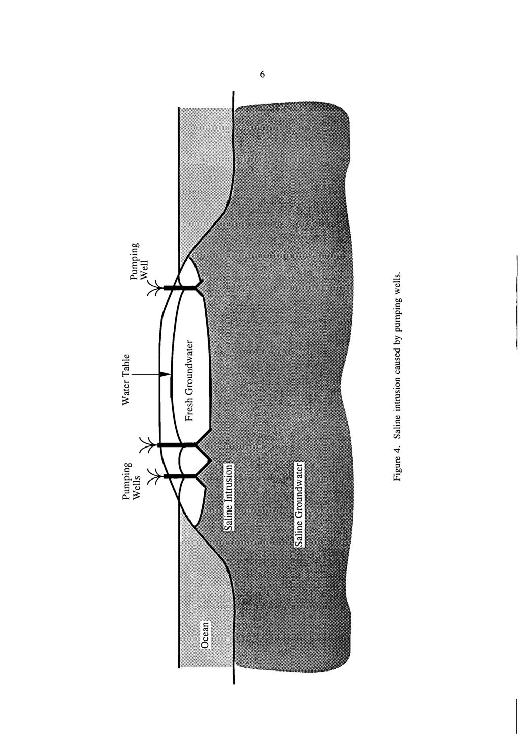
12 In the southern portion of the Yucatan Peninsula, somewhat different geologic environments exist, creating different environmental conditions. For example, surface water is evident in southern Quintana Roo, where swampy areas and some lakes have formed in depressions caused by down-dropping of large limestone blocks between faults (Lesser and Weidie, 1988). Water is maintained at the surface because clay and other less permeable materials have washed into the depressions, allowing them to retain some precipitation. The Rio Hondo, which forms the international border between Quintana Roo and Belize, also runs along one of these faults in the limestone. In addition, in the extreme southwestern part of the Yucatan, in southern and southwestern Campeche, a transition from the karst environment of the northern Yucatan to a non-karstic environment occurs. The geology of this zone consists of a mix of limestone and other types of rock, creating a different hydrologic regime not entirely controlled by karstic features. Surface water, including streams, lakes, and swamps, is evident, most notably in the Candelaria River drainage. This river originates in southern Campeche and northern Guatemala, and drains into the Gulf of Mexico through a large lagoon known as the Laguna de Terminos. Because of the presence of surface water in this area, water availability presents less of a problem than in most of the Yucatan. However, the region is relatively sparsely populated and not close to the rapidly growing tourist destinations in the northern Yucatan. For these reasons, this paper concentrates on dealing with water-related issues in the karstic regions of the Yucatan Water Sources Because of the lack of surface water in most of the Yucatan (as discussed above), groundwater provides the most significant source for water supplies. The ancient Maya drew groundwater from cenotes (large natural wells formed from collapsed sinkholes in the limestone) and from caves intersecting the water table. In some coastal areas, cenotes contain only a thin layer of freshwater floatin on brackish or saline water, and water supplies were drawn off this top layer (Back and Lesser, 1981).' Extensive construction of wells to augment these natural points of access to groundwater began after the Spanish conquest, at first with hand tools. Water was lifted from these wells by means of rope and bucket, either by hand or with the assistance of pack animals. Mechanical drilling and pumping equipment, including the use of windmills, were introduced in the 1800s and permitted a large expansion in the number of wells. Drilled wells equipped with electric pumps now provide the majority of water for the cities of the Yucatan. In coastal areas, the freshwater lens overlying saline groundwater is often quite thin. Excessive pumping of groundwater can therefore lead to saline water intrusion into aquifers and contamination of water supplies. This is illustrated in Figure 4, which shows how groundwater pumping can lead to drawdown of the water table and upconing of the underlying saline water into the zone of the well. To avoid this, drilled wells in these areas are often screened in the zone of freshwater and sealed in the underlying zone of saline groundwater. The well therefore draws from the freshwater part of the aquifer and the lower, sealed part of the well provides a small reservoir for freshwater flowing into the well. The storage provided by this sealed well casing allows the well to continue yielding water while maintaining a low rate of pumping to help avoid saline intrusion. Local exceptions to the exclusive use of groundwater have occurred in both modern and ancient times. To retain rainwater, the Maya constructed reservoirs in natural depressions in the limestone called aguadas by lining them with paving stones and clay (Back and Lesser, 1981). Natural depressions are still used to provide water for drinking and for agricultural purposes such as mixing and dilution of agricultural chemicals (Remmers and De Koeijer, 1992). Cisterns to collect and store rainwater were also constructed by the Maya, and cisterns are still used in some areas for storing rainwater. The following discussion of groundwater use draws from Back and Lesser (1981).
13

14 2.4. Wastewater Sinks The hydrologic environment described above presents problems for disposal of wastes as well as for water supply. Because of the high permeability of the limestone and lack of substantial soil cover in many parts of the peninsula, wastewater can infiltrate rapidly to the water table. Consequently, local contamination of groundwater often results from disposal of sewage into cenotes or waste pits. The lack of soil and rapid infiltration result in little natural organic decomposition or filtering of wastes (Back, 1983). Bacteria and virus laden sewage can therefore easily reach the water table. Once there, the karst environment provides more hospitable conditions for these organisms than most other subsurface environments. Groundwater typically provides an anaerobic (oxygen-free) environment in which many bacteria would not persist. However, karst aquifers with high permeability and rapid flow can maintain aerobic conditions in which many pathogens can persist. The warm climate of the Yucatan also helps to promote the growth of these organisms (Back, 1983). Water-quality studies of wells used for drinking water supply have found high levels of bacterial contamination in many wells in the Yucatan. For example, of 24 wells sampled by Doehring and Butler (1974), only four were uncontaminated, and seven samples contained levels of bacterial contamination that would be classified as unsuitable for drinking water even after treatment. Despite these problems, the authors note that water from these wells was not receiving any treatment before use. Septic tank outfalls can also contaminate groundwater with inorganic contaminants such as nitrates. Rapid infiltration and lack of soil reduce the effectiveness of the natural treatment processes that would help remove these compounds as they filtered through soil and/or rock. Contamination of groundwater by organic substances like sewage is not an irreversible process, and natural flushing and organic degradation could eventually help to improve groundwater quality. However, as long as disposal of wastes takes place in a manner that continues to contaminate the groundwater, water quality in the aquifers will not improve. Contamination of groundwater by sewage has forced the abandonment of many wells, especially where population is concentrated in cities. For example, Merida, the capital of the state of Yucatan, once had thousands of windmills pumping groundwater from household wells. These wells have been abandoned because of groundwater contamination by sewage. Water is now pumped from a well field outside the city and piped through a distribution network to residents (Back and Lesser, 1981). Several alternatives exist for disposal of municipal sewage in Yucatan cities. For cities near the coast, wastewater can be pumped offshore through pipelines and dispersed through diffusers which spread out the sewage so that it is not highly concentrated. Pathogenic organisms in sewage generally cannot survive in seawater, so that if any of the waste does circulate back to the shore, it would no longer be harmful if the diffusers were properly designed. Another alternative is to inject treated sewage into deep wells that penetrate the saline groundwater underlying the freshwater aquifer (Back and Lesser, 1981). Both alternatives are expensive and disposal of wastes directly into the ground will probably persist, especially outside of the larger cities. Contamination of groundwater by pesticides and other agricultural products may also present problems in the Yucatan in the future. The region has seen a rapid expansion of agriculture with intensive use of pesticides and fertilizers, especially in Quintana Roo. Because agricultural chemicals may be carried into the subsurface by water infiltrating into the ground, they may present additional problems of groundwater contamination in the future Marine Environment The Yucatan Peninsula has a large number of coves and lagoons along its shoreline. Along the eastern shoreline of the peninsula, many of the coves and lagoons are a result of dissolution of limestone along fractures in the rock and have no surface drainage into them. Rather, groundwater discharges directly into the ocean through openings in the limestone. Because of this, any contaminants contained in the groundwater may also reach the coves and lagoons.
15 In contrast, the large Laguna de Terminos in southwestern Campeche has a large number of rivers flowing into it. These rivers include several that originate within the Yucatan, such as the Candelaria River, as well as others that originate from other regions. Because Campeche is one of the major rice and sugar cane producers in Mexico, contamination with agricultural chemicals presents a concern for Laguna de Terminos (Gold-Bouchot et al., 1993). This is especially true because the area is also a major source of shrimp, which may accumulate contaminants such as pesticides and therefore present a health hazard to those eating the shellfish. Recent studies of the Rio Palizada, one of the rivers flowing into Laguna de Terminos, show that levels of pesticide contamination were generally low in shellfish and sediments in both the river and lagoon, and were not considered dangerous (Gold-Bouchot et al., 1993). Nevertheless, the presence of these compounds in shellfish and sediments from both the river and lagoon indicate that contamination with agricultural products is occurring and may present larger problems in the future. Coral reefs occur along the Yucatan coastline, notably around offshore islands such as Cozumel, and direct sewage discharge into the ocean negatively affects these reefs. Offshore oil development off the southwestern coast of Campeche also presents additional potential hazards to the marine environment of the Yucatan. A large oil spill occurred in these offshore fields in 1979 when an oil well blew out, releasing huge amounts of crude oil in the Gulf of Mexico. The spill was considered one of the worst ever at the time, and it took several months to cap the well and stop the release of oil. 3. WATER USE AND MANAGEMENT 3.1. Water Use in the Yucatan Peninsula Per capita water use in the Yucatan Peninsula is significantly lower than in Mexico as a whole, for several reasons. Irrigation, which is by far the largest consumer of water in Mexico, is much less common in the Yucatan than in the rest of the country. For example, in 1977, 96% of agriculture in the Yucatan was rain-fed while 30% of the cultivated area nationwide was irrigated (Garduiio et al., 1978). In addition, hydroelectric power generation, which accounts for the majority of water withdrawals in Mexico, is generally not utilized in the Yucatan because of the lack of surface water. In discussing water use, it is important to note this distinction between water consumptiorl and water withdrawal. Water that is consumed is unavailable for use elsewhere. In contrast, water that is withdrawn may not necessarily be consumed, as when it is used for hydroelectric power generation. So, for example, water used for irrigation or domestic purposes is largely consumed while water used in hydroelectric power generation is still available for other uses. Table 1 shows overall water use in terms of both consumption and withdrawals for Mexico as a whole and the Yucatan Peninsula for various years between 1970 and Figures in the table are based on information taken from various sources as indicated in the table.4 The figures for 2000 are based on water use projections made in As can be seen on the table, more information was available for Mexico as a whole than for the Yucatan Peninsula. More information about water use in the Yucatan, as well as information about trends in water use in specific sectors (such as tourism) in the region would be available in Spanish language government documents most easily obtained in Mexico.
16 Table 1. Water use in Yucatan and Mexico. All figures are in cubic meters/person/year unless otherwise noted. withdrawal consumption Mexico as a whole (estimated) total withdrawal (cubic kmlyear) withdrawal consumption Yucatan Peninsula (estimated) Sources of information: 1970 figures: Gonzalez-Villareal (1973) and 1970 census data figures (Mexico): WRI (1994) for withdrawal, Olaiz (1981) for consumption, and population estimates made from interpolations between 1970 and 1980 census data figures (Yucatan): Back and Lesser (1981) and population estimates as above figures: Garduiio (1985) and 1980 census data figures: Gonzalez-Villareal and Garduiio (1994) and population estimates made from 1990 census data figures: Garduiio (1985) and population estimates based on 1980 census (latest census available when these estimates of water use were made). For Mexico as a whole, with the exception of 1975, per capita withdrawals based on actual information (rather than future projections) remain fairly constant at about 2250 cubic meters/person/year.5 The anomalous nature of the 1975 numbers for Mexico as a whole appears even more striking when looking at total withdrawals, as shown in Table 1. It is doubtful that total withdrawals would decrease by over 50% (from 110 cubic kilometers to 54 cubic kilometers) between 1970 and 1975, a period when the Mexican population was increasing by over 3% per year. The 1975 total withdrawal figure for Mexico, therefore, appears to be based on erroneous or out of date information. As mentioned above, if this anomalous 1975 figure is ignored, per capita water withdrawals for Mexico as a whole remain fairly steady. Similarly, as shown on Table 1, per capita water consumption for the entire country between 1970 and 1994 is fairly constant at just over 700 cubic meters/person/year. Despite the projections of sharp increases in water use in Mexico by 2000, both per capita withdrawal and consumption have remained fairly constant. This does not imply that total water use is not increasing, only that population and water use are both increasing at the same time, resulting in fairly constant levels of per capita water withdrawal and consumption. The available information for the Yucatan, although less complete than for the entire country, also indicates that per capita water use remained fairly constant between 1976 and 1980, the period of most rapid population growth in the region. Again, this does not imply that total water use in the region did Fluctuations occur in the figures in the table for both Mexico and the Yucatan, and water use can appear to go down over time. This, however, is probably more of a result of the difficulties in measuring water use and population rather than an actual trend.
17 not increase, only that both population and water use increased at about the same rate. As mentioned above, both per capita withdrawals and per capita consumption are far lower in the Yucatan than for the rest of Mexico due to the lack of irrigation and hydropower in the region. Table 1 shows that withdrawals for the period were between 300 and 350 cubic meters/person/year, or 13 to 15% of the per capita withdrawal for Mexico as a whole Water Use and Total Water Availability Compared to some other regions of Mexico, such as Mexico City or the dry areas in the north of the country, the Yucatan Peninsula uses a small percentage of its available water resources. For example, Lesser (1976)7 estimated that water withdrawals in the form of groundwater pumping in the northern part of the peninsula were only about 4% of total groundwater recharge in that zone. Total withdrawals in 1980 for the entire Yucatan Peninsula were estimated to be 3% of the natural availability in the region by Gardufio (1985). The same author projected (in 1985) that total withdrawals in the Yucatan would rise to 12% of natural availability by 2000, although, as noted above, water use does not appear to be rising as rapidly as originally predicted. These calculations suggest that large additional supplies of water could be developed in the Yucatan; however, such conclusions need to be qualified by several caveats. As noted above, the lens of fresh groundwater in the Yucatan is quite thin, and excessive pumping can lead to saline intrusion and contamination of groundwater supplies. This problem is especially acute near the coasts, where many of the larger urban centers are located. The volume of usable water is therefore much more limited than the total natural availability in the entire region. Still, there are possibilities for increasing current levels of water use, and they are discussed in Section 4 below Projections of Future Water Demand Projections of total future water demand in the Yucatan can be made by utilizing the information from Table 1 on water use and future population projections for the region. Such projections can give an idea of hypothetical future water demand based on certain assumptions regarding water use and population growth. This hypothetical water demand can then be compared to the actual situation to see if water availability would present a problem in the future given the assumptions made. The assumptions made regarding future water use and population growth in the Yucatan are outlined in the following paragraphs. Although Table 1 shows that per capita water use for all of Mexico appeared to be fairly stable, water use information for the Yucatan was less available and less consistent. Therefore, the largest calculated per capita water use, or about 350 cubic meters/person/year, was chosen for making estimates of future water use. 8 Future population in the Yucatan was estimated through the use of several simple population scenarios for the region. These projections utilize a simple discrete exponential population growth function and As noted in Table 1, the withdrawal figure for the Yucatan in 1976 is not based on the same information as the withdrawal figure for all of Mexico for 1975, and they do not appear to contain the same anomalous information. As cited in Back and Lesser (1981). With increased development of tourism in the future, per capita water use in the Yucatan may rise because hotels and resorts tend to use large amounts of water. However, for the purpose of estimating overall future water demand in this paper, this figure based on available information was utilized.
18 are based on information about past population growth in the Yucatan and several ass~m~tions.~ Table 2 shows population data for the states in the Yucatan Peninsula from census data for 1960 to The table also gives the total population for the entire Yucatan Peninsula and for Mexico, and the annual population growth rates for all of these areas. As can be seen on the table, population in the Yucatan has grown more rapidly than in Mexico as a whole in recent years. This is especially true in Quintana Roo, which only attained statehood in Since that time, expanding tourism and federal government policies to settle the area have contributed to very rapid population growth. Table 2. Population growth over time: Yucatan States, Mexico. Area Population Population Growth (%/yr) Campeche Quintana Roo Yucatan Yucatan Peninsula Mexico as a whole 168, , , ,185 50,169 88, , , , ,355 1,063,733 1,362, ,437 1,098,061 1,710,271 2,391,402 34,923,129 48,225,238 66,846,833 81,249, The scenarios used to estimate future population in the Yucatan were based on information from Table 2 and several assumptions. The first scenario assumes that population growth will continue at the same overall rate of growth experienced by the entire peninsula during the period , or 3.4% per annum. In the second scenario, growth slows down gradually to the current national rate of growth in Mexico, which is about 2%. In this scenario, population growth in the Yucatan proceeds at a 3% annual rate for the period and then slows down to 2% per annum during The third scenario assumes that population growth in the Yucatan will be about the same as the national rate of growth in Mexico. In this scenario, the Yucatan population grows at a rate of 2% per year until 2025, and then slows down to a rate of 1.5% per year for the period The resulting populations in the Yucatan Peninsula under these three scenarios are shown in Table 3, along with the population of the region in Table 3. Population growth scenarios for the Yucatan. Scenario Population Current growth continued 2,391,402 7,730, Gradual slowing to national level growth 2,391,402 6,730, National level growth 2,39 1,402 4,780,000 It needs to be emphasized that these scenarios and the methods of calculation used in them are simplistic and have been generated for the purpose of estimating hypothetical future water demand in the Yucatan given certain assumptions. More refined population estimates would undoubtedly yield better predictions of future population growth in the region.
19 Given these population estimates and the level of per capita water use discussed above (350 cubic meters/person/year), total annual future water use can be calculated. This total annual water use can then be compared to average annual water availability as well. Table 4 presents both of these results. Total annual water use is calculated simply by multiplying the number of persons by per capita water use. The percentage of annual water availability represented by this level of water use is then calculated and shown on the table. In computing this percentage, the estimated annual amount of groundwater recharge for the entire peninsula is taken as annual water availability (13 billion cubic meterslyear).10 Although there is surface water available in some parts of the Yucatan (as discussed above in Section 2), groundwater is the principle resource utilized for water supply, and most population centers are generally not located near surface water supplies. Over the entire region, surface waters represented only about 3% of overall water withdrawals in 1980 (Gardufio, 1985). Table 4. Future water use in the Yucatan. Scenario Billion cubic meterslyear (% of natural availability) Withdrawal 2025 Withdrawal Current growth continued 2.7 (21%) 6.2 (48%) 2. Gradual slowing to national level growth 2.4 (18%) 3.9 (30%) 3. National level growth 1.7 (13%) 2.4 (18%) Given recent levels of growth in the Yucatan Peninsula (as shown in Table 2), it appears likely that population growth in the region will continue at rates higher than the national average. Table 4 shows that levels of growth in the Yucatan above the national average (i.e., scenarios 1 and 2) will result in a hypothetical water demand of about 20% of natural groundwater availability by 2025 and 30 to 50% by These water demands represent levels of groundwater extraction that are probably neither feasible nor sustainable, especially for the year As discussed above in Section 2, the geology and geography of the Yucatan have contributed to a situation in which groundwater tends to flow quickly through the hydrogeologic system rather than building up in storage. The amount of groundwater that can be pumped in any single location is therefore limited. Excessive pumping in limited areas could create or exacerbate problems such as saline intrusion. Pumping over wider areas would allow a greater overall yield, but introduce additional costs of water transport. As the population of the Yucatan is increasingly concentrated in urban areas, much of the groundwater is too far from centers of population to be economically developed. Other factors also limit the amount of groundwater that can be pumped. For example, as discussed above, some groundwater is polluted by sewage or other waste products and consequently is not suitable for all uses. In addition, in some areas such as the hilly region of southern Campeche, the depth to groundwater is too great to permit economical development of the resource. Because of these problems, it is more useful to talk about the level of sustainable groundwater yield in specific areas in the Yucatan with specific water needs rather than for the peninsula as a whole. Methods for determining sustainable yields for specific zones are discussed in Section 4 below. Nonetheless, the analysis of overall hypothetical future water demand in the entire region is useful in that it indicates that current patterns of water use in the Yucatan cannot be sustained given future population growth. Section 4 also discusses different methods for meeting future water demands in the Yucatan. As a greater proportion of available water resources is utilized, the potential consequences of natural occurrences such as droughts will also be greater. With more intense water use, the impacts of water lo from Gardutio (1985).
20 shortages will be more acute and widespread. Although the Yucatan has a humid climate, droughts are not unknown in the region. In the 1820s and 1830s, the peninsula suffered from several severe droughts, turning the region into "a disaster zone" (Sancho y Cervera and Perez-Gavilan, 1981). Dahlin (1983) also presents evidence that prolonged drought may have forced the abandonment of some Mayan cities in the northern Yucatan. In the future, with a larger population using a greater proportion of the available water resources, droughts will have the potential to once again severely affect the region Institutional Setting for Water Management The institutional setting surrounding water use and management in Mexico is currently undergoing several important changes with the implementation of new policies.11 According to the Mexican Constitution, water resources are owned by the state and water users require a concession or license from the federal government. So, for example, a city in the Yucatan such as Merida generally has a concession from the federal government to develop water supplies for that municipality. Likewise, all other users, public or private, require a permit or concession from the federal government to use water. Regulation of water use is the responsibility of the Comision Nacional de Aguas (CNA or National Water Commission), which was created in 1989 as a single federal agency charged with water management. CNA has established a water rights public register, in which concessions and permitted uses are being recorded. Under Mexico's new water policy, charges for rights of water use have been established. The new National Water Law of 1992, which emphasizes the nature of water as a commodity rather than a free good, also allows transfers of water rights under the supervision of CNA. In addition, the National Water Law encourages cost recovery from investments made in water infrastructure through higher tariffs for water use. With all of these mechanisms in place, privatization of some water supply systems is anticipated in the future. 4. MEETING FUTURE DEMANDS: METHODS TO MATCH WATER SUPPLY AND DEMAND The population of the Yucatan Peninsula is increasing at a relatively rapid rate (see Table 2), creating larger demand for water supplies. Traditional methods for ensuring adequate supplies of water have focused on increasing supply by developing additional resources or importing water from other regions. However, increased attention is also being paid to dealing with the demand side of the equation through more emphasis on water conservation and efficient use. In the context of the Yucatan, potential methods to increase supply include additional groundwater pumping, desalination, and use of rainwater and reclaimed wastewater, all of which are discussed in this section. Efforts to increase efficiency and promote conservation are also discussed, as they form a principle part of Mexico's water policy under the new National Water Law adapted in Increased Pumping of Groundwater Because groundwater represents the principle water resource in most of the Yucatan Peninsula, additional pumping of groundwater to meet growing water demands is probably inevitable in the region. Traditional storage reservoirs are not viable due to the lack of surface water in the form of rivers or streams. In addition, the highly permeable nature of the limestone means that surface reservoirs simply would not hold water without some form of grouting or sealing (LeGrand, 1973). For all of these reasons, groundwater will continue to be the main source of water supply for the Yucatan. Increased exploitation of this resource may lead to problems, however, if it is not carefully managed. " This section draws largely from Gonzalez-Villareal and Garduiio (1994).
21 As mentioned above (and illustrated in Figure 4), excessive pumping of groundwater can lead to contamination of wells with saline water. The Yucatan aquifer consists of a thin lens of fresh groundwater floating on top of saline groundwater. Depth to the saline groundwater is related to the elevation of the fresh water table above sea level: for every foot of freshwater above sea level, the freshwater-saline water interface is depressed about 40 feet below sea level (Back et al., 1982).12 Localized pumping of wells causes the water table to become depressed as water flows towards the pumping well. The resulting cone of depression around the well lowers the elevation of the water table and allows saline water from below to form a cone rising up towards the well. Because of the relationship described above, this upwelling of saline water will be about 40 times greater than the drawdown of the water table. Since the Yucatan freshwater aquifer is quite thin, even small drawdowns can cause problems of saline groundwater upwelling into wells. This upwelling of saline groundwater is not an irreversible process. Once pumping is stopped, aquifers usually quickly recover, at least under present conditions of relatively small withdrawals relative to natural availability. In order to avoid such contamination, pumping rates can be varied to minimize drawdown around wells and new wells can be located so as to avoid cumulative effects. Another technique that can be used is to drill horizontal shafts within the fresh groundwater zone, thereby drawing water from a wider area and minimizing drawdown (Doehring and Butler, 1974). Although accumulated knowledge may provide heuristic procedures for managing groundwater extraction to avoid saline intrusion problems, computer modelling can also be a very useful tool for aquifer management. Computer models of groundwater flow can be employed to simulate the effects of different pumping schemes and can help in identifying optimal locations and pumping rates for wells. Two phase groundwater flow models, which model the flow of two different fluids (in this case, fresh groundwater and saline groundwater), can be used to model how the interface between the two fluids moves in response to different pumping schemes. For example, Rivera et al. (1990), use a two-phase groundwater flow model to simulate how the salt water-freshwater interface moves in response to different rates of pumping in coastal wells in Veracruz, Mexico (not in the Yucatan). By predicting how that interface moves, the model can help to show what pumping schemes might lead to saline intrusion into pumping wells and how to manage pumping to avoid that problem. Such models may also be useful for the Yucatan, although they have certain limitations. Sufficient data is not always available to permit computer modelling of groundwater systems and computational requirements may be large. In addition, groundwater modelling in karst areas is often problematic because of the highly irregular nature of karst aquifer geology. Because subsurface water can flow through multiple solution channels and take many paths, karst aquifers often have very unpredictable flow patterns which are difficult to model.13 The use of groundwater flow models could help in assessing the effects of different proposals for future development of groundwater and assist in identifying well location and pumping schemes to minimize problems of saline intrusion. This would probably be most useful to do for specific zones where groundwater is extensively utilized rather than on a regional basis for the entire peninsula. Groundwater modelling could be used to help create a set of different scenarios for specific areas within the Yucatan based on proposed plans for additional groundwater development. The scenarios would contain '* 'This relationship comes from the Ghyben-Herzberg Principle which was developed to describe the position of a salt water-freshwater interface under idealized, static (i.e., no flow) conditions. Since it was first elaborated independently by Ghyben in 1889 and Herzberg in 1901, further work has modified it to reflect actual conditions, including groundwater flow and mixing and dispersion between the two fluids. Nonetheless, the Ghyben-Herzberg Principle still provides a tool for thinking about how changes in groundwater elevations change the position of the freshwater-saline water interface. l3 See Cullen and LaFleur (1982) for a discussion of the issues involved in simulating groundwater flow in karst aquifers.

22 information about where additional wells would be located, how much water could be pumped, and whether saline intrusion would be a problem within that given scenario. Users of a Yucatan PDE model would be presented with a range of possible alternative plans for additional utilization of groundwater resources in certain zones, for which results are already available and stored within the PDE program. This approach would be somewhat less flexible than linking a groundwater flow model to the PDE model, but it would be computationally much simpler and faster, and a range of possible alternative plans could be included Desalination Desalination has been utilized in Mexico to supply water for domestic or industrial use since the 1960s, but on a relatively small scale. The federal government has been involved in constructing over 65 desalination plants, mostly to supply small coastal fishing or tourist communities in dry areas like Baja California in northwestern Mexico (Siller, 1985). Industrial use of desalination is actually larger, mainly to provide high quality water for industrial uses and also to provide drinking water on offshore oil platforms. Some desalination facilities utilize brackish water rather than seawater which can lower the costs of the process (Probstein and Alvarez, 1976). Still, the costs of desalination tend to be high, "three to four times more expensive than conventional sources of freshwater" (WRI, 1992). Because of these high costs, desalination is not widely employed in the Yucatan. However, as the rapidly growing population puts more and more pressure on limited water resources, desalination may become a more viable option, especially since large amounts of brackish groundwater are relatively close to the surface in some parts of the peninsula Rainwater Harvesting Rainwater harvesting has been practiced in the Yucatan since the time of the ancient Maya, who collected precipitation in natural depressions and specially constructed cisterns. In some rural areas, natural depressions and cisterns are still used to collect rainwater to supplement other sources of water. Especially in the southern Yucatan Peninsula where rainfall is higher, rainfall catchment may provide an alternative for individual households to augment their water supplies. Other humid areas like the Hawaiian islands have continued to successfully apply age old practices to harvest rainwater (Fok et al., 1979), and these techniques may become increasingly popular in places like the Yucatan as more and more stress is placed on other water resources Wastewater Reclamation The reuse of reclaimed wastewater is practiced in some larger Mexican cities that have severe water supply problems, including Mexico City and Monterrey (Martinez, 198 1). Utilizing treated wastewater for some industrial and municipal uses, such as cooling and watering parks and gardens, reduces the amount of high quality water needed. In the case of Mexico City, treated wastewater is reused to both reduce the amount of water that must be imported into the Valley of Mexico to supply the huge urban population and also to reduce the volume of wastewater, much of which also needs to be re-exported from the valley. Monterrey is located in the dry north of Mexico and needs to reuse treated wastewater due to limited natural water supplies. Tijuana, located across the border from San Diego, California, also reuses treated wastewater for irrigated agriculture, and small settlements whose residents farm the irrigated fields have sprung up near the wastewater treatment facility. Although wastewater reclamation and reuse entail treatment costs to ensure that the reused water does not cause health problems, it has some distinct advantages, especially for areas with scarce water resources. Wastewater reuse reduces the extent to which new water supplies need to be developed, because some uses of water are supplied with reclaimed water. The cost of treating wastewater for reuse may actually be smaller than, for example, developing new and distant sources and transporting
EL PASO S DESALINATION EFFORTS
 El Paso s Desalination Efforts WATER DESALINATION AND REUSE STRATEGIES FOR NEW MEXICO SEPTEMBER NEW MEXICO WATER RESOURCES RESEARCH INSTITUTE 2004 Bill Hutchison has more than 20 years of experience as
If there is magic on this planet, it is contained in water.
 If there is magic on this planet, it is contained in water. Loren Eiseley ~ American philosopher and nature writer ~ b.1907 d.1977 Above: A swimmer rests in the X Keken Cenote underground pool in the town
Xaman-Ha city, an answer to the poor growth and spread population
 Xaman-Ha city, an answer to the poor growth and spread population Global aspect In The Mexican Republic we can found three zones with an important tourist movement; the metropolitan area of Mexico City,
Blocking Sea Intrusion in Brackish Karstic Springs
 European Water 1/2: 17-23, 3. 3 E.W. Publications Blocking Sea Intrusion in Brackish Karstic Springs The Case of Almiros Spring at Heraklion Crete, Greece A. Maramathas, Z. Maroulis, D. Marinos-Kouris
Hydrological study for the operation of Aposelemis reservoir Extended abstract
 Hydrological study for the operation of Aposelemis Extended abstract Scope and contents of the study The scope of the study was the analytic and systematic approach of the Aposelemis operation, based on
3.0 OVERVIEW OF HUECO BOLSON
 3.0 OVERVIEW OF HUECO BOLSON The Hueco Bolson covers about 2,500 square miles, or 1.6 million acres in New Mexico, Texas, and Chihuahua (Figure 3-1). In Texas, the Hueco overlies portions of El Paso and
Indian Ocean Small Island States: Indicators of Dangerous Anthropogenic Influences of Climate Change?
 Indian Ocean Small Island States: Indicators of Dangerous Anthropogenic Influences of Climate Change? Prepared for: AGU Fall Meeting San Francisco CA December 5, 2005 Prepared by: Bill Mills Chih-Fang
CYPRUS Country Report
 CONFERENCE OF THE WATER DIRECTORS OF THE EURO-MEDITERRANEAN AND SOUTHEASTERN EUROPEAN COUNTRIES CYPRUS Country Report by Christodoulos Artemis Director Water Development Department Athens, 6 & 7 November
Module 1 Educator s Guide: Representative Discussion Points Investigation 3
 Module 1 Educator s Guide: Representative Discussion Points Investigation 3 Ethiopia and Eritrea Our combined population is 59,578,171 people. We have just emerged from a long period of civil war and famine.
Intermediate report. Letter of agreement FAO - GCB/RAB/013/ITA
 Treated waste water for sustainable production of valuable biomass, soil and water quality improvement and combating desertification in Algeria and Tunisia Letter of agreement FAO - GCB/RAB/013/ITA Intermediate
Caribbean Coastal Pollution Project (CCPP)
") Caribbean Coastal Pollution Project (CCPP) Tracking the Sources of Coastal Zone Contamination in the Maya Riviera Region of Mexico Report on Research Project December 11, 2009 United Nations University
Caribbean Coastal Pollution Project (CCPP) Tracking the Sources of Coastal Zone Contamination in the Maya Riviera Region of Mexico Report on Research Project December 11, 2009 United Nations University
Your web browser (Safari 7) is out of date. For more security, comfort and the best experience on this site: Update your browser Ignore
 is out of date. For more security, comfort and the best experience on this site: Update your browser Ignore") Your web browser (Safari 7) is out of date. For more security, comfort and the best experience on this site: Update your browser Ignore Activitydevelop THE RIVIERA MAYA HAS A SECRET How does expanding
Your web browser (Safari 7) is out of date. For more security, comfort and the best experience on this site: Update your browser Ignore Activitydevelop THE RIVIERA MAYA HAS A SECRET How does expanding
SUMMER VILLAGE OF SILVER SANDS. Municipal Development Plan
 SUMMER VILLAGE OF SILVER SANDS Municipal Development Plan Bylaw 253-2014 Adopted August 22, 2014 Summer Village of Silver Sands Municipal Development Plan Bylaw No. 253-2014 Page 2 1 INTRODUCTION 1.1 SETTING
Unit 9 The Middle East SG 1 - Physical Geography, Population & Demographics
 Unit 9 The Middle East SG 1 - Physical Geography, Population & Demographics I. Physical Geography A. The Middle East includes southwestern Asia and North Africa. 1. The name is Eurocentric. Middle East
Region 1 Piney Woods
 Region 1 Piney Woods Piney Woods 1. This ecoregion is found in East Texas. 2. Climate: average annual rainfall of 36 to 50 inches is fairly uniformly distributed throughout the year, and humidity and temperatures
Regional Economic Report April June 2012
 Regional Economic Report April June 2012 September 13, 2012 Outline I. Introduction II. Results April - June 2012 A. Economic Activity B. Inflation C. Economic Outlook III. Final Considerations Introduction
Stephanie C. Haas Digital Library Center University of Florida Libraries Gainesville, FL
 OF FRACTURED EARTH AND LIQUID GEMS: THE SPRINGS OF FLORIDA Stephanie C. Haas Digital Library Center University of Florida Libraries Gainesville, FL haas@smathersnt2.uflib.ufl.edu Springs occur in the fractured
COSTA MAYA HIGH POTENTIAL INVESTMENT OPPORTUNITY & PROPOSAL
 COSTA MAYA HIGH POTENTIAL INVESTMENT OPPORTUNITY & PROPOSAL Introduction This investment analysis and proposal was developed to provide investors with an accurate representation of the investment potential
IATA ECONOMIC BRIEFING FEBRUARY 2007
 IATA ECONOMIC BRIEFING FEBRUARY 27 NEW AIRCRAFT ORDERS KEY POINTS New aircraft orders remained very high in 26. The total of 1,834 new orders for Boeing and Airbus commercial planes was down slightly from
Geoscape Toronto The Oak Ridges Moraine Activity 2 - Page 1 of 10 Information Bulletin
 About 13,000 years ago as the Laurentide Ice Sheet melted, glacial meltwater accumulated between the ice sheet and the Niagara Escarpment. This formed a lake basin into which gravel and sand were deposited.
The Problem.. SuDS: Controlling the Flow. LANDF RM Technical delivery of SuDS 15/10/2013. Bridget Woods Ballard HR Wallingford 1.
 SuDS: Controlling the Flow 15th October 2013 Bridget Woods Ballard The Problem.. Page 2 Bridget Woods Ballard HR Wallingford 1 15th October 2013 Landform Event Page 3 HR Wallingford 2013 The Aim of SuDS.
Methodology. Results. Table 1. Summary of Strengths (S), Weaknesses (W), Opportunities (O) and Threats (T) to promote the Mayan Zone of Quintana Roo.
, Weaknesses (W), Opportunities (O) and Threats (T) to promote the Mayan Zone of Quintana Roo.") Introduction Promoting a developmental tourism in the Mayan Zone of Quintana Roo is one of the government s main issues, so in the National Development Plan 2006-2012, in the line of action 2, it considers
Introduction Promoting a developmental tourism in the Mayan Zone of Quintana Roo is one of the government s main issues, so in the National Development Plan 2006-2012, in the line of action 2, it considers
STUDY OF ALAQI SECONDARY CHANNEL IN LAKE NASSER
 ABSTRACT STUDY OF ALAQI SECONDARY CHANNEL IN LAKE NASSER GamalSallam 1, Mohamed Ihab 2, and Waleed Emary 3 Associate Professor, National Water Research Center, Email: gasallam@yahoo.com Civil Engineer,
Case Study: 1. The Clarence River Catchment
 Case Study: 1. The Clarence River Catchment The NSW coastline is a great natural asset, making an enormous contribution to the economy. The resources of coastal catchments such as the Clarence River Catchment,
What Is An Ecoregion?
 Ecoregions of Texas What Is An Ecoregion? Ecoregion a major ecosystem with distinctive geography, characteristic plants and animals, and ecosystems that receives uniform solar radiation and moisture Sometimes
REDD+ IN YUCATAN PENINSULA
 REDD+ IN YUCATAN PENINSULA JOINING FORCES TO PRODUCE AND PRESERVE 2 3 Campeche, Yucatan, and Quintana Roo combat deforestation together in the Yucatan Peninsula and build a new path for growth A peninsular
Water resource situation of the Republic of Djibouti
 Water resource situation of the Republic of Djibouti Omar ASSOWE DABAR Integrating Groundwater Management within River Basins 15-17 January 2019 Nairobi, Kenya Regional Training Workshop on Introduction
Coverage of Mangrove Ecosystem along Three Coastal Zones of Puerto Rico using IKONOS Sensor
 Coverage of Mangrove Ecosystem along Three Coastal Zones of Puerto Rico using IKONOS Sensor Jennifer Toledo Rivera Geology Department, University of Puerto Rico, Mayagüez Campus P.O. Box 9017 Mayagüez,
Successful Experiences in Rio Grande/Rio Bravo Watershed Management
 Successful Experiences in Rio Grande/Rio Bravo Watershed Management 5 th th World Water Forum Istanbul, Turkey March 22-23, 23, 2009 Introduction A watershed with many voices a medley of cultures, customs,
Benton County Karstic Mapping Project. Barbara France, Dustin Kochen, Tiffany Clark, John Maloney Paul Lowery's Environmental Geology
 Benton County Karstic Mapping Project Barbara France, Dustin Kochen, Tiffany Clark, John Maloney Paul Lowery's Environmental Geology Intro Karst refers to an area of bedrock that is very susceptible to
How much did the airline industry recover since September 11, 2001?
 Catalogue no. 51F0009XIE Research Paper How much did the airline industry recover since September 11, 2001? by Robert Masse Transportation Division Main Building, Room 1506, Ottawa, K1A 0T6 Telephone:
Silvia Giulietti ETIS Conference Brussels An EEA reporting mechanism on tourism and environment and ETIS
 Silvia Giulietti ETIS Conference Brussels 28.01.2016 An EEA reporting mechanism on tourism and environment and ETIS Main content Why tourism and environment? Why a reporting mechanism on tourism and environment
COUNTRY CASE STUDIES: OVERVIEW
 APPENDIX C: COUNTRY CASE STUDIES: OVERVIEW The countries selected as cases for this evaluation include some of the Bank Group s oldest (Brazil and India) and largest clients in terms of both territory
Statistical Evaluation of BMP Effectiveness in Reducing Fecal Coliform Impairment in Mermentau River Basin
 Statistical Evaluation of BMP Effectiveness in Reducing Fecal Coliform Impairment in Mermentau River Basin Z.-Q. Deng 1 and H. Chowdhary 2 1 Assistant Professor, Department of Civil and Environmental Engineering,
Mexico. Chapter 10. Chapter 10, Section
 Chapter 10, Section World Geography Chapter 10 Mexico Copyright 2003 by Pearson Education, Inc., publishing as Prentice Hall, Upper Saddle River, NJ. All rights reserved. Chapter 10, Section World Geography
Hurricane Keith Assessment of Damages and Needs Analysis
 Page 1 of 7 The Pan American Health Organization Promoting Health in the Americas National Emergency Management Organization of Belize Damage Assessment and Evaluation Committee Hurricane Keith Assessment
Prosjekt Lesina Mediteranean sea Coastal lagoon
 Prosjekt Lesina Mediteranean sea Coastal lagoon PERIODE 2012-2015 LAND The Lesina Lagoon, alternatively known as the Lake of Lesina due to its small and previously fleeting hydrological connection to the
Environmental Management System for Tourist Accommodations in Amphawa, Samut Songkram,Thailand
 Abstract Amphawa is the most popular weekend destination for both domestic and international tourists in Thailand. More than 112 homestays and resorts have been developed along the water resources. This
VI. ALTERNATIVES TO THE MASTER PLAN C. RENOVATED EAST BUILDING ALTERNATIVE
 VI. ALTERNATIVES TO THE MASTER PLAN C. RENOVATED EAST BUILDING ALTERNATIVE INTRODUCTION The Renovated East Building Alternative would include the continued use of the renovated West Building and the renovation
Sustainable tourism in Holbox through local development
 Sustainable Tourism II 319 Sustainable tourism in Holbox through local development A. Palafox, V. Pineda, J. Godínez & M. Martínez Universidad de Quintana Roo, Mexico Abstract According to the Bank of
Regional Economic Report July- September 2014
 Regional Economic Report July- September 2014 December 11, 2014 Outline I. Introduction II. Results July September 2014 A. Economic Activity B. Inflation C. Economic Outlook III. Final Remarks Introduction
There are actually six geographic sub-regions, three in both the uplands and the lowlands.
 6 Regions of AR Although Arkansas is most easily divided into two distinct geographical regions, the northwestern uplands and the southeastern lowlands, this description does not accurately portray the
Brine Lithium Properties Chile For Sale/Option
 Brine Lithium Properties Chile For Sale/Option 3 Brine Lithium Properties 10,800 Ha (25,686 acres) on 3 Salars 2 Salar de Atacama The highest grade lithium salar in the world Salar de Atacama is the world's
Just how big is Africa?
 The United States China India The United Kingdom Portugal Spain France Belgium Germany The Netherlands Switzerland Italy Eastern Europe Japan 11.7 million sq. miles Just how big is Africa? Chapter 18 Section
Discussion on the Influencing Factors of Hainan Rural Tourism Development
 2018 4th International Conference on Economics, Management and Humanities Science(ECOMHS 2018) Discussion on the Influencing Factors of Hainan Rural Tourism Development Lv Jieru Hainan College of Foreign
 AGREEMENT Between Director of the Białowieża National Park, based in Białowieża (Poland) and Director of the National Park Bialowieża Forest, based in Kamieniuki (Belarus) and Head Forester of the Białowieża
"ST. KLIMENT OHRIDSKI FACULTY OF GEOLOGY AND GEOGRAPHY
 SOFIA UNIVERSITY "ST. KLIMENT OHRIDSKI FACULTY OF GEOLOGY AND GEOGRAPHY APPLICATION OF THE MODEL "DRIVING FORCES PRESSURE STATE - RESPONSE FOR ASSESSMENT OF FLOOD RISK RADOSTINA BORISOVA DOCHEVA Bachelor
EFFECT OF THE COASTAL CONSERVATION DUE TO BEACH NOURISHMENT OF TOTORI SAND DUNE COAST
 Proceedings of the 7 th International Conference on Asian and Pacific Coasts (APAC 203) Bali, Indonesia, September 2-26, 203 EFFECT OF THE COASTAL CONSERVATION DUE TO BEACH NOURISHMENT OF TOTORI SAND DUNE
ReefFix. May, For the Organization of American States (OAS) and the Inter-American Biodiversity Information Network (IABIN)
 and the Inter-American Biodiversity Information Network (IABIN)") Fondation pour la Protection de la Biodiversité Marine FoProBiM B.P. 642 www.foprobim.org (mail) 6011 Henning St. Port-au-Prince, Haiti Bethesda, MD 20817 ReefFix Rapid Assessment of the Economic Value
Fondation pour la Protection de la Biodiversité Marine FoProBiM B.P. 642 www.foprobim.org (mail) 6011 Henning St. Port-au-Prince, Haiti Bethesda, MD 20817 ReefFix Rapid Assessment of the Economic Value
SHIP MANAGEMENT SURVEY* July December 2015
 SHIP MANAGEMENT SURVEY* July December 2015 1. SHIP MANAGEMENT REVENUES FROM NON- RESIDENTS Ship management revenues dropped marginally to 462 million, following a decline in global shipping markets. Germany
LAUNCH OF THE COASTAL ZONE MANAGEMENT TRUST
 A 60km stretch of coastline on the Yucatan Peninsula of Mexico is the testing ground for an idea that could protect fragile environments around the world: insuring coral reefs. The Economist World Ocean
Chapter 20. The Physical Geography of Africa South of the Sahara
 Chapter 20 The Physical Geography of Africa South of the Sahara Chapter Objectives Identify the major landforms, water systems, and natural resources of Africa south of the Sahara. Describe the relationship
PERMANENT MISSION OF BELIZE TO THE UNITED NATIONS
 PERMANENT MISSION OF BELIZE TO THE UNITED NATIONS 675 Third Ave. Suite 1911 New York, New York 10017 Tel: (212) 986-1240/(212) 593-0999 Fax: (212) 593-0932 E-mail: blzun@belizemission.com STATEMENT DELIVERED
Regional Economic Report April June 2013
 Regional Economic Report April June 213 September 12, 213 Outline I. Introduction II. Results April - June 213 A. Economic Activity B. Inflation C. Economic Outlook III. Final Considerations Introduction
RIO VISTA MUNICIPAL AIRPORT
 DRAINAGE TECHNICAL MEMORANDUM RIO VISTA MUNICIPAL AIRPORT RIO VISTA, CALIFORNIA Prepared for: City of Rio Vista 1 Main Street Rio Vista, CA 94571 (707) 374-5337 Prepared by: August 2012 Copyright 2012
Settlement Patterns West of Ma ax Na, Belize
 SETTLEMENT PATTERNS WEST OF MA AX NA, BELIZE 1 Settlement Patterns West of Ma ax Na, Belize Minda J. Hernke Faculty Sponsor: Kathryn Reese-Taylor, Department of Sociology/Archaeology ABSTRACT The focus
Latin America and The Caribbean. A Closer Look.
 Latin America and The Caribbean A Closer Look. Mexico Capital: Mexico City The Location of Mexico Mexico is the second-largest country by size and population in Latin America.but the Largest Spanish -
The Isonzo/Soca river basin
 Geneva September 8 th 2014 The Isonzo/Soca river basin Status and perspective on the possible Alpine river basin to be assessed The Alpine Convention Water management, risk management and adaptation to
CHAPTER IV OVERVIEW. Indonesia. The capital is Dompu. Dompu Regency has an area of 2, km².
 CHAPTER IV OVERVIEW A. General Description of the Research Sites Dompu Regency, is a district in West Nusa Tenggara Province, Indonesia. The capital is Dompu. Dompu Regency has an area of 2,321.55 km².
Typical avalanche problems
 Typical avalanche problems The European Avalanche Warning Services (EAWS) describes five typical avalanche problems or situations as they occur in avalanche terrain. The Utah Avalanche Center (UAC) has
Small Island States in Indian and Atlantic Oceans: Vulnerability of Water Resources to Climate Change and other Stresses
 Small Island States in Indian and Atlantic Oceans: Vulnerability of Water Resources to Climate Change and other Stresses Prepared for: EWRI 05 World Water and Environmental Resources Congress Anchorage
IATA ECONOMICS BRIEFING
 IATA ECONOMICS BRIEFING NEW AIRCRAFT ORDERS A POSITIVE SIGN BUT WITH SOME RISKS FEBRUARY 26 KEY POINTS 25 saw a record number of new aircraft orders over 2, for Boeing and Airbus together even though the
UNIT 5 PHYSICAL GEOGRAPHY SG 1 - PART I
 UNIT 5 PHYSICAL GEOGRAPHY SG 1 - PART I Africa is HUGE! I. LANDFORMS A. Plateaus - an area of relatively level high ground. 1. Africa s interior is dominated by series of plateaus and elevated basins such
port of brisbane Information Guide
 port of brisbane Information Guide A B O U T U S The Port of Brisbane, managed by the Port of Brisbane Pty Ltd, is Queensland s largest general cargo and container port, and a driver of economic growth
PPCR/SC.4/5 October 9, Meeting of the PPCR Sub-Committee Washington, D.C. October 28, REVIEW OF ON-GOING WORK OF THE MDBs IN DJIBOUTI
 PPCR/SC.4/5 October 9, 2009 Meeting of the PPCR Sub-Committee Washington, D.C. October 28, 2009 REVIEW OF ON-GOING WORK OF THE MDBs IN DJIBOUTI Proposed Sub-Committee Decision The Sub-Committee reviewed
The Challenges for the European Tourism Sustainable
 The Challenges for the European Tourism Sustainable Denada Olli Lecturer at Fan S. Noli University, Faculty of Economy, Department of Marketing, Branch Korça, Albania. Doi:10.5901/mjss.2013.v4n9p464 Abstract
IATA ECONOMIC BRIEFING DECEMBER 2008
 ECONOMIC BRIEFING DECEMBER 28 THE IMPACT OF RECESSION ON AIR TRAFFIC VOLUMES Recession is now forecast for North America, Europe and Japan late this year and into 29. The last major downturn in air traffic,
Provincial Review 2016: Limpopo
 Provincial Review 2016: Limpopo Limpopo s growth since 2003 has been dominated by the mining sector, especially platinum, and by national construction projects. As a result, the provincial economy grew
Regional impacts and vulnerability mountain areas
 Regional impacts and vulnerability mountain areas 1 st EIONET workshop on climate change vulnerability, impacts and adaptation EEA, Copenhagen, 27-28 Nov 2007 Klaus Radunsky 28 Nov 2007 slide 1 Overview
Effluent Guidelines for Airport Deicing Discharges
 Effluent Guidelines for Airport Deicing Discharges Airports Council International and Airlines for America s Deicing Management Conference May 23, 2012 ELG Background Effluent limitations guidelines and
MIÑO O AND LIMIA BASINS
 Miño-Sil MIÑO O AND LIMIA BASINS José Álvarez Díaz Sil River Basin District s s Planning Office, Spain WORKSHOP ON TRANSBOUNDARY WATER RESOURCES BUDAPEST, HUNGARY, 8-10 FEBRUARY 2011 INDEX 1. OVERVIEW
US Spa Industry Study
 University of Massachusetts Amherst ScholarWorks@UMass Amherst Tourism Travel and Research Association: Advancing Tourism Research Globally 2014 Marketing Outlook Forum - Outlook for 2015 US Spa Industry
Regional Economic Report April June 2015
 Regional Economic Report April June 2015 September 10, 2015 Outline I. Regional Economic Report II. Results April June 2015 A. Economic Activity B. Inflation C. Economic Outlook III. Final Remarks Regional
Kurobegawa No.4 Power Plant Toyama Prefecture, Japan (Asia)
") IEA Hydropower Implementing Agreement Annex VIII - Hydropower Good Practices: Environmental Mitigation Measures and Benefits Case Study 14-02: Development of Regional Industries Kurobegawa No.4 Power Plant,
IEA Hydropower Implementing Agreement Annex VIII - Hydropower Good Practices: Environmental Mitigation Measures and Benefits Case Study 14-02: Development of Regional Industries Kurobegawa No.4 Power Plant,
SIAVONGA DISTRICT
 SIAVONGA DISTRICT --------------------------------------------------------------------------------------------------------- 1.0 Physical Environment Siavonga District is characterized by an escarpment
Mood of the Nation New Zealanders' perceptions of international visitors. March 2018
 Mood of the Nation New Zealanders' perceptions of international visitors March 2018 Contents 1 Background and approach 3 2 Key insights 6 3 Detailed insights 10 4 Appendix: measures by region 31 2 1 Background
Water in the Amazon. By Heather and Georgie
 Water in the Amazon By Heather and Georgie The Amazon is the world s largest tropical rainforest. The Amazon is so big that the U.K and Ireland would fit into it 17 times. The Amazon River It s length
Crisis and Strategic Alliance in Aviation Industry. A case study of Singapore Airlines and Air India. Peter Khanh An Le
 Crisis and Strategic Alliance in Aviation Industry A case study of Singapore Airlines and Air India National University of Singapore 37 Abstract Early sights of recovery from the US cultivate hope for
THE STORY OF MALDIVES. DR MARIYAM SHAKEELA Minister Of Environment and Energy Republic Of Maldives
 THE STORY OF MALDIVES DR MARIYAM SHAKEELA Minister Of Environment and Energy Republic Of Maldives Significance of ecotourism & coral reefs on regional economy Coral reefs are among the most diverse and
Analysis of the impact of tourism e-commerce on the development of China's tourism industry
 9th International Economics, Management and Education Technology Conference (IEMETC 2017) Analysis of the impact of tourism e-commerce on the development of China's tourism industry Meng Ying Marketing
Thessaloniki Chamber of Commerce & Industry TCCI BAROMETER. March Palmos Analysis. March 11
 Thessaloniki Chamber of Commerce & Industry TCCI BAROMETER March 2011 Palmos Analysis March 11 TCCI BAROMETER (Executive Summary) Thessaloniki Chamber of Commerce and Industry (TCCI), consistent to its
Paul Griffiths 544 Springbok Road Campbell River British Columbia CANADA V9W 8A2
 Paul Griffiths 544 Springbok Road Campbell River British Columbia CANADA V9W 8A2 Phone: 250-923-1311 Fax: 250-923-6211 Email: pgriff@island.net BC Ministry of Environment Environmental Assessment Office
Brief Description of Northern the West Bank, Palestine Prepared by: Dr. Ahmed Ghodieh Department of Geography An-Najah National University Nablus,
 Brief Description of Northern the West Bank, Palestine Prepared by: Dr. Ahmed Ghodieh Department of Geography An-Najah National University Nablus, Palestine Brief Description of Northern the West Bank
Section 2 North Slope Ecoregions and Climate Scenarios
 Section 2 North Slope Ecoregions and Climate Scenarios North Slope Ecoregions The geographic/ecological scope of the workshop will be freshwater and terrestrial systems of the North Slope of Alaska, with
Economy 3. This region s economy was based on agriculture. 4. This region produced items such as textiles, iron, and ships in great quantities. For th
 Geography 1. This region has a climate of warm summers and snowy cold winters. 2. This region has a climate that is generally warm and sunny, with long, hot, humid summers, and mild winters, and heavy
Lidar Imagery Reveals Maine's Land Surface in Unprecedented Detail
 Maine Geologic Facts and Localities December, 2011 Lidar Imagery Reveals Maine's Land Surface in Unprecedented Detail Text by Woodrow Thompson, Department of Agriculture, Conservation & Forestry 1 Introduction
APPENDIX D: SUSTAINABLE TRAIL DESIGN. APPENDICES Town of Chili Parks and Recreation Master Plan Update
 APPENDIX D: SUSTAINABLE TRAIL DESIGN APPENDICES Town of Chili Parks and Recreation Master Plan Update Sustainable Trail Construction Sustainable trails are defined by the US Forest Service as trails having
Antarctic glaciers' melt is happening more rapidly than was first believed
 Antarctic glaciers' melt is happening more rapidly than was first believed By Los Angeles Times, adapted by Newsela staff on 05.20.14 Word Count 908 This undated handout photo provided by NASA shows the
Antarctic glaciers' melt is happening more rapidly than was first believed
 Antarctic glaciers' melt is happening more rapidly than was first believed By Los Angeles Times, adapted by Newsela staff on 05.20.14 Word Count 908 This undated handout photo provided by NASA shows the
SUTTER COUNTY. General Plan Update Technical Background Report
 SUTTER COUNTY General Plan Update Technical Background Report February 2008 SUTTER COUNTY GENERAL PLAN UPDATE TECHNICAL BACKGROUND REPORT PREPARED FOR: SUTTER COUNTY PREPARED BY: PBS&J IN PARTNERSHIP
Iceland. Tourism in the economy. Tourism governance and funding
 Iceland Tourism in the economy Tourism has been among the fastest-growing industries in Iceland in recent years and has established itself as the third pillar of the Icelandic economy. Domestic demand
ICRI Monaco January 2010
 Economic Valuation of Coral Reefs in the Caribbean ICRI Monaco January 2010 Lauretta Burke World Resources Institute (WRI) Beautiful Valuable Valuable Valuable Valuable Valuable Photos: Krishna Desai Valuable
Mediterranean Europe
 Chapter 17, Section World Geography Chapter 17 Mediterranean Europe Copyright 2003 by Pearson Education, Inc., publishing as Prentice Hall, Upper Saddle River, NJ. All rights reserved. Chapter 17, Section
Maximising Beneficial Reuse through the use of a Novel Dredging Contract
 Maximising Beneficial Reuse through the use of a Novel Dredging Contract Nicola Clay & Katherine Harris Port of London Authority Nick Bray Dredging Research Paul Hesk Van Oord UK CEDA Dredging Days 2007
The Geological Pacific Northwest. Wednesday February 6, 2012 Pacific Northwest History Mr. Rice
 The Geological Pacific Northwest Wednesday February 6, 2012 Pacific Northwest History Mr. Rice 1 Free Response #2 Please do not simply list the items for this response. Full sentences!!! Minimum of 3-5
Applying Geospatial Tools to Produce Data for SDG Indicators in Mexico
 Applying Geospatial Tools to Produce Data for SDG Indicators in Mexico Inter-Agency and Expert Group On SDGs Indicators Enrique Ordaz Francisco J. Jimenez Stockholm November 2018 Background INEGI has produced
4. Hydrology of the Olentangy River Watershed
 4. Hydrology of the Olentangy River Watershed The Hydrologic Cycle Water on Planet Earth is dynamic constantly being recycled from the land to the atmosphere to the ocean. Rivers and streams are just a
Actual Climatic Conditions in ERB. Online Resource 1 corresponding to:
 Actual Climatic Conditions in ERB. Online Resource 1 corresponding to: Article Title: Climatic Trends and Impact of Climate Change on Agriculture in an Arid Andean Valley. Journal Name: CLIMATIC CHANGE
Lake Trout Population Assessment Wellesley Lake 1997, 2002, 2007
 Lake Trout Population Assessment Wellesley Lake Prepared by: Lars Jessup Fish and Wildlife Branch November 2009 Lake Trout Population Assessment Wellesley Lake Yukon Fish and Wildlife Branch TR-09-01 Acknowledgements
LOCATION, CLIMATE, AND NATURAL RESOURCES OF MEXICO
 SS6G3 The student will explain the impact of location, climate, distribution of natural resources, and population distribution on Latin America and the Caribbean. a. Compare how the location, climate,