Benton County Karstic Mapping Project. Barbara France, Dustin Kochen, Tiffany Clark, John Maloney Paul Lowery's Environmental Geology
|
|
|
- Marilyn Byrd
- 5 years ago
- Views:
Transcription

1 Benton County Karstic Mapping Project Barbara France, Dustin Kochen, Tiffany Clark, John Maloney Paul Lowery's Environmental Geology
2 Intro Karst refers to an area of bedrock that is very susceptible to dissolution by acidity levels in the water that travels around and through it. Karstic features are things like caves, sinkholes and fissures. These features occur mostly in areas who's bedrock is made either of limestone or dolomite. This makes the effect of karst features in an area especially interesting to us because almost all of northwest Arkansas sits on top of either limestone or dolomite.
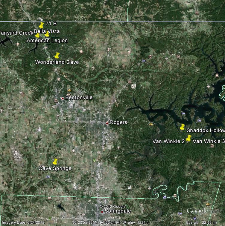
3 Project overview We have taken pictures and recorded the GPS coordinates of approximately 10 different karstic sites within the Benton County area. We used this information to create an easy to understand map that can be viewed on the internet by the general public. By mapping these karstic features in our county, we will be creating a new source of public knowledge where one had not existed before.
4 Community We aim to provide a knowledge base to be used by city planners, water departments, tourists and the general public. Increase understanding of Benton county's geological features, as well as increase awareness and conservation of these areas. Provide information about Benton county's karstic systems and other Arkansas geological processes to out of state enthusiasts via our website.
5 Curriculum Possess a foundation in environmental geology prerequisite for higher level courses. Relate geological principles to environmental issues. Recognize the relationships between humans and the environment, particularly the effects of population growth on natural systems. Gain understanding into how the scientific method is applied to environmental issues
6 Technology GIS Geographic Information System GPS Global Positioning System Microsoft power point Digital Cameras Internet research
7 Skills Developed Networking GIS operation GPS Map making Communication skills Teamwork Research Scientific evaluation skills Critical thinking
8 Division of Labor Barb- research/ site selection/photograph/gps/website/powerpoint Dustin- research/ site selection/photograph/gps/website/powerpoint Tiffany- research/ site selection/photograph/gps/website/pamphlet
9 Time line Sept 26 Barbara contacted Joyce Higgins, set up meeting Oct 8 Research on Karstic features on internet/ Barbara Barb plotted points at locations in Bella Vista Sept 29 Meet with Joyce Higgins/ both Barbara and Tiffany interviewed. Oct 15 Tiffany started working on informational brochures,met with Denis Dean Dustin working on GIS Oct 3 Dustin/Barb plotted points at Hobbs park area/ both took photographs/barb used GPS Tiffany/Dustin/Barb plotted points in Bella Vista area Barb took pictures/ Dustin took pictures/ Tiffany used GPS
10 Time line Nov. 16 Barb collecting research Dustin working on power point Nov. 26 Barb, Dustin, Tiffany met with Diane to work on EMPACTS webpage Nov. 28 Barb, Dustin, Tiffany met with Diane to work on EMPACTS webpage, downloaded pics that were taken, imported GPS sites, Tiffany finalized brochures Dec. 3 Discussed over between Barb, Tiffany, Dustin what was needed to finalize project Barb modifying powerpoint
11 Dec. 4 Met with Diane for last time to link webpage and powerpoint. Dec 6 Present to class/ Barb, Tiffany, Dustin all participate. Time line
12 Division of Labor Barbara Meet with J. Higgins Photography Web page design Research Dustin Meet with R. Hignight GPS plotting Map design Research Tiffany Meet with J. Higgins Photography Karstic history research Met with D. Dean
13 Methodology Each group member selected at least 3 areas of known karst terrain to locate and photograph. Each member participated in traveling to their chosen sites, and documented the feature that was found along with a GPS coordinate of the location. These locations were compiled and used to create a publicly editable google map as well as an arcgis map.
14 Outcome GIS overlay highlighting karstic areas. Web page with karstic map designed to allow new points to be entered. Karst location photos. Research information pertaining to local groundwater contamination and other hazards.
15 Benton County Known Sites Latitude Longitude Location Site Feature Van Winkle 1 B1 Fissure Spring House B2 Spring Van Winkle 2 B3 Fissure Van Winkle 3 B4 Fissure Shaddox Hollow B5 Cave Wonderland Cave B6 Cave Tanyard Creek B7 Cave American Legion B8 Cave Lowes Site B9 Fissure B B10 Fissure Cave Springs B11 Cave
16

17 Our local ecosystem s sensitivity is severely complicated by the fact that northwest Arkansas is one of the fastestgrowing metropolitan areas in the United States. Residential and industrial developments have been built or are planned to be built directly on top of these fragile underground Karstic areas. Content Knowledge

18 Content Knowledge Karst can lead to uneven settling. This can cause cracks in the floor, walls and foundation, weakening a building's structural integrity. Engineering plans need to include ways to compensate for differential compaction in areas showing karst topography.

19 Content Knowledge In areas where there has been pipe leakage, overpumping, etc., subsurface cavities can form causing a slow subsidence of the affected area or a sudden collapse of the affected soil and structure above it.

20 Content Knowledge The porous and fractured nature of karst also makes it very susceptible to pollution. After it rains, runoff enters the aquifer quickly and transfers any and all unfiltered contaminants.
21 Content Knowledge The extensive network of karstic waterways beneath our county lacks the impermeable boundaries that other aquifers possess, making it easy for contamination to spread quickly and over long distances. This can have a costly impact on the water quality for the residents of communities within the area.
22 Content Knowledge Our community sits on a fragile and in some ways dangerous geological structure. If we are to keep from harming it and avoid having it harm us we have a need to educate ourselves and understand our situation.
23 geology.arkansas.gov earth.google.com GIS Denis Dean Joyce Higgins Dianne Phillips References /Environmental%20Geology/Karst%20bent on/karstb.htm
24 Resources Our Web Page: /Environmental%20Geology/Karst%20ben ton/karstb.htm The google map: To help the map grow contact for editing rights.
Stephanie C. Haas Digital Library Center University of Florida Libraries Gainesville, FL
 OF FRACTURED EARTH AND LIQUID GEMS: THE SPRINGS OF FLORIDA Stephanie C. Haas Digital Library Center University of Florida Libraries Gainesville, FL haas@smathersnt2.uflib.ufl.edu Springs occur in the fractured
Paul Griffiths 544 Springbok Road Campbell River British Columbia CANADA V9W 8A2
 Paul Griffiths 544 Springbok Road Campbell River British Columbia CANADA V9W 8A2 Phone: 250-923-1311 Fax: 250-923-6211 Email: pgriff@island.net BC Ministry of Environment Environmental Assessment Office
The Importance of Education in Karst Protection: the Virginia Experience
 The Importance of Education in Karst Protection: the Virginia Experience Carol Zokaites, Karst Eduction Coordinator Wil Orndorff, Karst Protection Coordinator Natural Heritage Karst Program Virginia Department
If there is magic on this planet, it is contained in water.
 If there is magic on this planet, it is contained in water. Loren Eiseley ~ American philosopher and nature writer ~ b.1907 d.1977 Above: A swimmer rests in the X Keken Cenote underground pool in the town
Oak Ridges Moraine: Southern Ontario's Sponge
 Oak Ridges Moraine: Southern Ontario's Sponge Lesson Overview Students will examine the location and the importance of the Oak Ridges Moraine and investigate ongoing conflicts concerning its development.
Arizona National Scenic Trail
 1 The Arizona National Scenic Trail is an 800 mile recreation trail from Mexico to Utah that connects mountain ranges, canyons, deserts, forests, wilderness areas, historic sites, trail systems, points
Protection and Sustainable Use of the Dinaric Karst Transboundary Aquifer System
 Protection and Sustainable Use of the Dinaric Karst Transboundary Aquifer System Second Workshop "River Basin Commissions and Other Joint Bodies for Transboundary Water Cooperation: Technical Aspects "
Minimal Impact Caving Guidelines
 Minimal Impact Caving Guidelines Photograph Brendan Marris 2016 Introduction Caving is a fascinating recreational activity which attracts the interest of a diverse range of people and groups, who all benefit
2.0 PARK VISION AND ROLES
 2.0 PARK VISION AND ROLES 2.1 Significance in the Protected Area System Marble Range and Edge Hills provincial parks protect 6.8% of the Pavillion Ranges Ecosection, which is located in the Southern Interior
USDA Trails Strategy WRI: ENGLISH PEAK SURVEY. Theodore Mendoza San Diego State University June 6 th 2016 August 18 th Advisor: Sam Commarto
 WRI: ENGLISH PEAK SURVEY Theodore Mendoza San Diego State University June 6 th 2016 August 18 th 2016 Advisor: Sam Commarto Klamath National Forest Submitted: March 21, 2017 Table of Contents Acknowledgements
Procedia Earth and Planetary Science 13 ( 2015 ) th Applied Isotope Geochemistry Conference, AIG-11 BRGM
 th Applied Isotope Geochemistry Conference, AIG-11 BRGM") Available online at www.sciencedirect.com ScienceDirect Procedia Earth and Planetary Science 13 ( 2015 ) 256 260 11th Applied Isotope Geochemistry Conference, AIG-11 BRGM Investigating the Origin and Interaction
Available online at www.sciencedirect.com ScienceDirect Procedia Earth and Planetary Science 13 ( 2015 ) 256 260 11th Applied Isotope Geochemistry Conference, AIG-11 BRGM Investigating the Origin and Interaction
Typical avalanche problems
 Typical avalanche problems The European Avalanche Warning Services (EAWS) describes five typical avalanche problems or situations as they occur in avalanche terrain. The Utah Avalanche Center (UAC) has
THE BIG PICTURE. Week of March 11, City of Buda Accepting Applications For Boards and Commissions
 City of Buda Accepting Applications For Boards and Commissions The deadline is approaching to submit applications for the City of Buda's various boards and commissions. Deadline to submit a completed application
MIDDLE SCHOOL CURRICULUM TR AILING ICE AGE M YST ERI E S ICE AGE TREKKING
 MIDDLE SCHOOL CURRICULUM TR AILING ICE AGE M YST ERI E S ICE AGE TREKKING CONTENTS I. Enduring Knowledge... 3 II. Teacher Background... 3 III. Before Viewing this Video... 5 IV. Viewing Guide... 5 V. Discussion
The Impact of Human Activities on Dolines (Sinkholes) Typical Geomorphologic Features on Karst (Slovenia) and Possibilities of their Preservation
 Typical Geomorphologic Features on Karst (Slovenia) and Possibilities of their Preservation") ISSN 0354-8724 (hard copy) ISSN 1820-7138 (online) The Impact of Human Activities on Dolines (Sinkholes) Typical Geomorphologic Features on Karst (Slovenia) and Possibilities of their Preservation Cernatič-Gregorič
ISSN 0354-8724 (hard copy) ISSN 1820-7138 (online) The Impact of Human Activities on Dolines (Sinkholes) Typical Geomorphologic Features on Karst (Slovenia) and Possibilities of their Preservation Cernatič-Gregorič
Your web browser (Safari 7) is out of date. For more security, comfort and the best experience on this site: Update your browser Ignore
 is out of date. For more security, comfort and the best experience on this site: Update your browser Ignore") Your web browser (Safari 7) is out of date. For more security, comfort and the best experience on this site: Update your browser Ignore Activitydevelop THE RIVIERA MAYA HAS A SECRET How does expanding
Your web browser (Safari 7) is out of date. For more security, comfort and the best experience on this site: Update your browser Ignore Activitydevelop THE RIVIERA MAYA HAS A SECRET How does expanding
Visit of Chinese representatives of the International Research Centre for Karst (IRCK) to the CKH
 to the CKH") Visit of Chinese representatives of the International Research Centre for Karst (IRCK) to the CKH The International Research Center on Karst (IRCK) was formed in 2008 in Guilin, China under the Auspices
Visit of Chinese representatives of the International Research Centre for Karst (IRCK) to the CKH The International Research Center on Karst (IRCK) was formed in 2008 in Guilin, China under the Auspices
WORKSHEET 1 Wilderness Qualities or Attributes Evaluating the Effects of Project Activities on Wilderness Attributes
 WORKSHEET 1 Wilderness Qualities or Attributes Evaluating the Effects of Project Activities on Wilderness Attributes Date: 3/7/2017 Roadless Area: Ruby South Description of Project Activity or Impact to
GEOTECHNICAL AND ENVIRONMENTAL APPLICATIONS OF KARST GEOLOGY AND HYDROLOGY
 PROCEEDINGS OF THE EIGHTH MULTIDISCIPLINARY CONFERENCE ON SINKHOLES AND THE ENGINEERING AND ENVIRONMENTAL IMPACTS OF KARSTS LOUISVILLE / KENTUCKY / 1-4 APRIL 2001 GEOTECHNICAL AND ENVIRONMENTAL APPLICATIONS
UNIT 5 PHYSICAL GEOGRAPHY SG 1 - PART I
 UNIT 5 PHYSICAL GEOGRAPHY SG 1 - PART I Africa is HUGE! I. LANDFORMS A. Plateaus - an area of relatively level high ground. 1. Africa s interior is dominated by series of plateaus and elevated basins such
Welcome Land Use Element... LU-1
 Welcome Land Use Element... LU-1 Land Use Plan... LU-3 Residential Land Uses... LU-12 Commercial Land Uses... LU-14 Mixed Use... LU-16 Industrial Land Uses... LU-18 Automobile-Related Land Uses... LU-19
Mud Creek and West Mud Creek
 Mud Creek and West Mud Creek Recreational Use Attainability Analysis Summary of Findings Texas Institute for Applied Environmental Research Stephenville, Texas September 15, 2014 1 Project Partners Texas
Clam Harbour Provincial Park
 Clam Harbour Provincial Park Public Engagement Session Thursday, September 14 th, 2017 5:30pm 7:30pm Webbers Store 11470 Nova Scotia Trunk 7 Lake Charlotte, NS Agenda Overview of the Provincial Parks System
Protection and Sustainable Use of the DINARIC KARST AQUIFER SYSTEM
 Protection and Sustainable Use of the DINARIC KARST AQUIFER SYSTEM 1. the context What is Karst? Karst is a special type of geologic environment that is formed by dissolution and corrosion of soluble rocks,
Little Limestone Lake Provincial Park. Draft Management Plan
 Little Limestone Lake Provincial Park Draft Management Plan Little Limestone Lake Provincial Park Draft Management Plan Table of Contents 1. Introduction... 3 2. Background... 3 3. Planning context...
Sustainable management of karstic areas in Wallonia Results and prospects
 Sustainable management of karstic areas in Wallonia Results and prospects The CWEPSS White Paper Executive summary of the Ecokarst 100 - published by the CWEPSS - June 2015. Commission Wallonne d Etude
Ecohydrology of karst poljes and their vulnerability
 Ecohydrology of karst poljes and their vulnerability Prof. emeritus O. Bonacci Faculty of Civil Engineering, Architecture and Geodesy, Split University, 21000 Split, Matice hrvatske 15, Croatia E-mail:
Arkansas State Highway and Transportation Department. Bella Vista Rotary Club
 Arkansas State Highway and Transportation Department Bella Vista Rotary Club Wednesday, August 12, 2015 Arkansas Highway & Transportation AHTD Quick Facts 3rd Largest State Agency (3,634 employees) Maintain
SAULT COLLEGE SAULT STE. MARIE, ONTARIO COURSE OUTLINE
 SAULT COLLEGE SAULT STE. MARIE, ONTARIO COURSE OUTLINE COURSE TITLE: Trail Construction and Facility Maintenance CODE NO. : NRT 260 SEMESTER: 3 PROGRAM: AUTHOR: Adventure Recreation and Parks Brian Anstess
Potomac Gorge. Resource Booklet. A Natural Monument in the Shadow of National Monuments. Bridging the Watershed. Potomac Gorge 75
 Potomac Gorge Potomac Gorge A Natural Monument in the Shadow of National Monuments Resource Booklet Bridging the Watershed An outreach program of the Alice Ferguson Foundation in partnership with the National
Natural and man-made flooding hazards at the torrents in the town of Thessaloniki
 Risk Analysis VII PI-373 Natural and man-made flooding hazards at the torrents in the town of Thessaloniki S. Stefanidis, F. Tziaftani & C. Chatzicristaki Institute of Mountainous Water Management and
Seismic Microzonation in Hurghada City (EGYPT)
") Available online at www.sciencedirect.com Procedia Engineering 14 (2011) 2856 2863 The Twelfth East Asia-Pacific Conference on Structural Engineering and Construction Seismic Microzonation in Hurghada
Available online at www.sciencedirect.com Procedia Engineering 14 (2011) 2856 2863 The Twelfth East Asia-Pacific Conference on Structural Engineering and Construction Seismic Microzonation in Hurghada
LEADERSHIP CENTER EXTERNAL MARKETING GUIDELINES
 LEADERSHIP CENTER EXTERNAL MARKETING GUIDELINES 2 JULY 2018 Our team at The Ritz-Carlton Leadership Center values our relationship with you and appreciates your business. We understand that The Ritz-Carlton
NWAC Blog. Cornices - don't walk the line! Written by Robert Hahn on March 14, Last update on May 15, 2017.
 NWAC Blog Cornices - don't walk the line! Written by Robert Hahn on March 14, 2017. Last update on May 15, 2017. Human-triggered cornice fall avalanche from March 10th, 2017. The crown release exposed
Florida resort residents rush out as building collapses into sinkhole
 Florida resort residents rush out as building collapses into sinkhole By Orlando Sentinel, adapted by Newsela staff on 08.13.13 Word Count 527 Buildings collapse into a sinkhole at the Summer Bay Resort
RESEARCH REPORT. Globalization: Creating a Common Language. Sustainability Committee. Promoting ecotourism as a tool for sustainable environment
 HISAR SCHOOL JUNIOR MODEL UNITED NATIONS 2018 Globalization: Creating a Common Language Sustainability Committee Promoting ecotourism as a tool for sustainable environment RESEARCH REPORT Recommended by:
International Snow Science Workshop
 A PRACTICAL USE OF HISTORIC DATA TO MITIGATE WORKER EXPOSURE TO AVALANCHE HAZARD Jake Elkins Jackson Hole Mountain Resort, Teton Village, Wyoming Bob Comey* Jackson Hole Mountain Resort, Teton Village,
EO-based services to support humanitarian operations: monitoring population and natural resources in refugee/idp camps
 How satellites can help to save lives Vienna, Austria 23 February 2016 EO-based services to support humanitarian operations: monitoring population and natural resources in refugee/idp camps Petra FÜREDER
LPBF/UNO APPENDIX A Overlays Maps &
 APPENDIX A Maps & Overlays HOW TO USE THE FOLLOWING MAPS AND S: Several lessons instruct you to use the maps in this Appendix. 1. 2. 3. 4. First, make a transparency of each map required for the activity.
Self-Guided Group Organization - Recommendations
 Self-Guided Group Organization - Recommendations Introduction The purpose of this document is to offer a template to self-guided groups with respect to pre-trip and on-trip planning. The ultimate goal
USDA TRAILS STRATEGY PROGRAM
 USDA TRAILS STRATEGY PROGRAM WRPI Program: English Peak Survey Jorge D. Briceño Southwestern Community College Internship Time Period: June 6, 2016 August 8, 2016 Advisor: Sam Commarto Recreation Officer
Welcome. Green Line in Your Community
 Welcome Green Line in Your Community Today s session will provide you with information on options The City is exploring for connecting the Green Line in the Beltline to the future Inglewood/Ramsay station.
Airports in the Region Case Study
 Crystal City Plan Feasibility Study Arlington, Virginia Planning for Redevelopment near Ronald Reagan Washington National Airport By Alex Iams, Arlington Economic Development Arlington County planners
1. Overview of Aberdeen Township and Its Waterfront
 Aberdeen 1. Overview of Aberdeen Township and Its Waterfront 1.1 Geographic Overview Aberdeen Township is a suburban township with a land area of 5.45 square miles, with about 2 miles of shoreline along
Geoscape Toronto The Oak Ridges Moraine Activity 2 - Page 1 of 10 Information Bulletin
 About 13,000 years ago as the Laurentide Ice Sheet melted, glacial meltwater accumulated between the ice sheet and the Niagara Escarpment. This formed a lake basin into which gravel and sand were deposited.
DOWNLOAD OR READ : SPRINGS AND WELLS IN GREEK AND ROMAN LITERATURE THEIR LEGENDS AND LOCATIONS SCHOLARS CHOICE EDITION PDF EBOOK EPUB MOBI
 DOWNLOAD OR READ : SPRINGS AND WELLS IN GREEK AND ROMAN LITERATURE THEIR LEGENDS AND LOCATIONS SCHOLARS CHOICE EDITION PDF EBOOK EPUB MOBI Page 1 Page 2 springs and wells in greek and roman literature
Blue Hills Nature Day Camp
 Blue Hills Nature Day Camp at Chickatawbut Hill 1904 Canton Avenue Milton, MA DISCOVER. EXPLORE. BE OUTSIDE! SUMMER 2018 About Blue Hills Summer Camp Our unique location atop scenic Chickatawbut Hill invites
Destruction of dolines: the examples from Slovene karst
 Destruction of dolines: the examples from Slovene karst dr. Gregor Kovačič (1) and dr. Nataša Ravbar (2) (1) University of Primorska, Faculty of humanities Koper, Science and Research Centre, Koper, Slovenia
SF1363 / HF 1061: Legacy Funding; Conference Agreement
 - Conference 1 Art 1 - Outdoor Heritage Fund 2 3 Prairies 4 WMA, SNA, & Prairie Bank Easement Acq. Phase III 5 Accelerated Prairie Restoration - Phase III 6 MN Buffers for Wildlife & Water 7 Northern Tallgrass
Photopoint Monitoring in the Adirondack Alpine Zone
 Photopoint Monitoring in the Adirondack Alpine Zone Julia Goren (PI) and Seth Jones Adirondack High Peaks Summit Steward Program Adirondack Mountain Club summit@adk.org PO Box 867, Lake Placid, NY 12946
Recreational Use Attainability Analysis Summary of Findings & Public Comment
 The Neches River Above Lake Palestine, Prairie Creek, Mud Creek, and West Mud Creek Recreational Use Attainability Analysis Summary of Findings & Public Comment Texas Institute for Applied Environmental
Number of tourism trips of residents increased namely for leisure
 Tourism Demand of Residents 1 st Quarter 2018 25 July 2018 Number of tourism trips of residents increased namely for leisure In the 1 st quarter 2018, residents in Portugal took a total of 4.5 million
Logo Department Name Agency Organization Organization Address Information 5700 North Sabino Canyon Road
 Logo Department Name Agency Organization Organization Address Information United States Forest Coronado National Forest 5700 North Sabino Canyon Road Department of Service Santa Catalina Ranger District
Fire and Forestry in Oxbow Regional Park, GIS and GPS Implementation
 Fire and Forestry in Oxbow Regional Park, GIS and GPS Implementation Brian Handy, Karen Sexton, Robert Pierce GIS and GPS implementation at Oxbow Regional Park, Oregon, in the preparation for fire danger
Recreational Services Plan. Gatineau Park. Phase 1: Planning Framework
 Recreational Services Plan Gatineau Park Phase 1: Planning Framework 1 Plan Planning in Gatineau Park Gatineau Park : an overview Trends Preliminary assessment Strategic framework 2 Unique natural and
CRAZY HORSE TRAIL GUIDE
 CRAZY HORSE TRAIL GUIDE Abridged Version: July 2016 This is a short form of our interpretive trail guide for the Crazy Horse Trail. The full version of the guide has a more detailed description of the
Environmental Management System for Tourist Accommodations in Amphawa, Samut Songkram,Thailand
 Abstract Amphawa is the most popular weekend destination for both domestic and international tourists in Thailand. More than 112 homestays and resorts have been developed along the water resources. This
Global Sustainable Tourism Destinations Criteria
 Global Sustainable Tourism Destinations Criteria Draft destination level Global Sustainable Tourism Criteria as proposed after Destinations and International Standards joint working group meeting and follow-up
RE: Access Fund Comments on Yosemite National Park Wilderness Stewardship Plan, Preliminary Ideas and Concepts
 September 30, 2016 Superintendent Yosemite National Park Attn: Wilderness Stewardship Plan P.O. Box 577 Yosemite, CA 95389 RE: Access Fund Comments on Yosemite National Park Wilderness Stewardship Plan,
Aquatic insect surveys at Mount Magazine State Park and Hobbs State Park Conservation Area with implementation of an educational component
 Aquatic insect surveys at Mount Magazine State Park and Hobbs State Park Conservation Area with implementation of an educational component Arkansas is home to a relatively large number of endemic invertebrates
Wilderness Research. in Alaska s National Parks. Scientists: Heading to the Alaska Wilderness? Introduction
 Wilderness Research in Alaska s National Parks National Park Service U.S. Department of Interior Scientists: Heading to the Alaska Wilderness? Archeologist conducts fieldwork in Gates of the Arctic National
Course Outline 10/29/ Santa Teresa Blvd Gilroy, CA COURSE: AFT 134 DIVISION: 50 ALSO LISTED AS: SHORT TITLE: AVIATION FLIGHT TECH
 5055 Santa Teresa Blvd Gilroy, CA 95023 Course Outline COURSE: AFT 134 DIVISION: 50 ALSO LISTED AS: TERM EFFECTIVE: Spring 2014 Inactive Course SHORT TITLE: AVIATION FLIGHT TECH LONG TITLE: Aviation Flight
Tourism Impacts and Second Home Development in Coastal Counties: A Sustainable Approach
 Tourism Impacts and Second Home Development in Coastal Counties: A Sustainable Approach Brunswick, Currituck and Pender Counties, North Carolina (Funded by North Carolina Sea Grant) Center for Sustainable
Effects of Groundwater on Salinity in Biscayne Bay
 Effects of Groundwater on Salinity in Biscayne Bay Sarah Bellmund1, Greg Graves2, Steve Krupa2, Herve Jobert3, Greg Garis1, and Steve Blair4 1Biscayne National Park Salinity Monitoring Program, Biscayne
Pathogens and Grazing Livestock
 Pathogens and Grazing Livestock Steve Ensley DVM, PhD 10/16/09 Water Borne Pathogens This presentation will have a specific emphasis on water borne pathogens. NUMBERS OF IOWA WATER SOURCES WITH Stream/River
Creating a User-Driven Long-Distance OHV Trail Through Partnering
 Joseph Raffaele Outdoor Recreation Planner U.S. Bureau of Land Management Yuma, Arizona Creating a User-Driven Long-Distance OHV Trail Through Partnering BLM is a multiple-use land management agency within
The Rufford Foundation Final Report
 The Rufford Foundation Final Report Congratulations on the completion of your project that was supported by The Rufford Foundation. We ask all grant recipients to complete a Final Report Form that helps
Icao Erg Code 2016 Manual READ ONLINE
 Icao Erg Code 2016 Manual READ ONLINE Dec 16, 2016 ERG GUIDE ICAO. Published 17/12/2016 ICAO DOC Series 2016. Please click on ICAO Logo for DOC Series. Please click on IMDG Code Pic. Eposta ile (Code 404)
Recent Erosion and Mass Wasting Observed in Sunset Cliffs Natural Park. Craig Barilotti and Camilla Ingram Sunset Cliffs Association
 Recent Erosion and Mass Wasting Observed in Sunset Cliffs Natural Park Craig Barilotti and Camilla Ingram Sunset Cliffs Association 15 February 2011 Executive Summary A major source of nearshore pollution
Country Report of the Democratic People s Republic of Korea
 Country Report of the Democratic People s Republic of Korea (22 nd Session of MAB-ICC) MAB National Committee of the DPRK 2010. 4 1. Activities of the MAB National Committee The DPR Korea MAB National
White Oak Creek. Recreational Use Attainability Analysis Summary of Findings. Texas Institute for Applied Environmental Research Stephenville, Texas
 White Oak Creek Recreational Use Attainability Analysis Summary of Findings Texas Institute for Applied Environmental Research Stephenville, Texas August 8, 2016 Sulphur Springs, Texas August 9, 2016 Mount
Our brand is our identity and enables us to build and maintain our profile within the areas we work. This guide will help you create the materials we
 Brand Guidelines. Our brand is our identity and enables us to build and maintain our profile within the areas we work. This guide will help you create the materials we use to communicate with our colleagues,
AQUIFER VULNERABILITY MAPPING IN KARSTIC TERRAIN ANTAMINA MINE, PERU
 AQUIFER VULNERABILITY MAPPING IN KARSTIC TERRAIN ANTAMINA MINE, PERU David Evans, Ground Water International, Lima, Peru. Henri Letient, Compañia Minera Antamina, Lima, Peru Tom Aley, Ozark Underground
NEW WEB TOOL FOR UNDERSTANDING BIOLUMINESCENT BAYS
 NEW WEB TOOL FOR UNDERSTANDING BIOLUMINESCENT BAYS Fernando Gilbes Santaella* and William Hernandez GERS Lab-Department of Geology University of Puerto Rico at Mayaguez *fgilbes@uprm.edu RESEARCH COMPONENT
Manitoba Technical-Vocational Curriculum Framework of Outcomes. Grades 9 to 11 Pilot Ground School 2018 Draft
 Manitoba Technical-Vocational Curriculum Framework of Outcomes Grades 9 to 11 Pilot Ground School 2018 Draft Goal 1: Describe and apply appropriate health and safety practices. GLO 1.1: Describe and apply
A GIS Assessment of Erosion Vulnerability for Unofficial Trails in the Columbia River Gorge
 A GIS Assessment of Erosion Vulnerability for Unofficial Trails in the Columbia River Gorge Sachi Arakawa Geog 593 Digital Terrain Analysis Fall 2017 Abstract The city of North Bonneville, located along
Table 1: Iron Mountain Communication Site. Latitude 1 Longitude 1 Elev 2 Address T/R/S 3 APN 4 USGS Quadrangle
 County of Riverside Public Safety Enterprise Communication Project Appendix A: Candidate Site Descriptions Overview The site is located in San Bernardino County near several communication towers in the
Seasonal Variability of the Groundwater Regime for Several Aquifers in Bulgaria Tatiana Orehova 1
 Seasonal Variability of the Groundwater Regime for Several Aquifers in Bulgaria Tatiana Orehova 1 The purpose of the paper is to analyse the seasonal variability of the groundwater regime for several aquifers
FNORTHWEST ARKANSAS WESTERN BELTWAY FEASIBILITY STUDY
 FNORTHWEST ARKANSAS WESTERN BELTWAY FEASIBILITY STUDY EXECUTIVE SUMMARY The 2030 Northwest Arkansas Regional Transportation Plan developed by the Northwest Arkansas Regional Planning Commission (NWARPC)
D1 January 8, 2014 Public Hearing APPLICANT: HUNT CLUB FARM
 D1 January 8, 2014 Public Hearing APPLICANT: HUNT CLUB FARM PROPERTY OWNER: HUNT CLUB A-1- A, LLC. STAFF PLANNER: Kevin Kemp REQUEST: Modification of a Conditional Use Permit approved by the City Council
RECREATION OPPORTUNITY SPECTRUM CLASSIFICATION IN NATURAL TOURISM ATTRACTIONS, CHIANG RAI PROVINCE
 RECREATION OPPORTUNITY SPECTRUM CLASSIFICATION IN NATURAL TOURISM ATTRACTIONS, CHIANG RAI PROVINCE Author names: Ms.KhwanruethaiKrongyut 1,Ms.Duangsiri Poomvichuvech 2, Ms.Narumon Suman 1 Email address:
Caribbean Coastal Pollution Project (CCPP)
") Caribbean Coastal Pollution Project (CCPP) Tracking the Sources of Coastal Zone Contamination in the Maya Riviera Region of Mexico Report on Research Project December 11, 2009 United Nations University
Caribbean Coastal Pollution Project (CCPP) Tracking the Sources of Coastal Zone Contamination in the Maya Riviera Region of Mexico Report on Research Project December 11, 2009 United Nations University
RACER Properties in Saginaw Area
 RACER Properties in Saginaw Area Bruce Rasher, Redevelopment Manager brasher@racertrust.org Saginaw Area, MI Overview See Buena Vista Township View map for details See Saginaw View map for details 2017
Duncan Hastie, P.E. Dewberry
 FEMA s Riverine High Water Marks for Atlanta s September 2009 Flood Event Duncan Hastie, P.E. Dewberry Background High Water Mark Recovery Performed Through FEMA s Hazard Mitigation Technical Assistance
Curriculum Vitae. Maria Aivalioti Environmental Engineer, M.Sc., Ph.D. PERSONAL INFORMATION Date of birth: 7 th November 1980
 Curriculum Vitae Maria Aivalioti Environmental Engineer, M.Sc., Ph.D. PERSONAL INFORMATION Date of birth: 7 th November 1980 Place of birth: Chania Crete Greece Nationality: Greek Family status: Married
MANAGEMENT DIRECTION STATEMENT
 Lower Mainland District MAAGEMET DIRECTIO STATEMET January 2001 for Liumchen Ecological Reserve Ministry of Environment Lands and Parks BC Parks Division Table of Contents Page Introduction... 1 Purpose
Course Information. Required Text: AIARE Student Manual. (Instructor will provide on Day 1 of the course)
") Red Rocks Community College Spring 2017 Outdoor Studies OUT 168 Avalanche Awareness I Course Information Instructor: John MacKinnon, Outdoor Education- Adjunct Faculty Cell # 970 236 6130 Email: john.mackinnon@rrcc.edu
Red Rocks Community College Spring 2017 Outdoor Studies OUT 168 Avalanche Awareness I Course Information Instructor: John MacKinnon, Outdoor Education- Adjunct Faculty Cell # 970 236 6130 Email: john.mackinnon@rrcc.edu
Tourism Impacts and Second Home Development in Pender County: A Sustainable Approach
 Tourism Impacts and Second Home Development in Pender County: A Sustainable Approach (Funded by North Carolina Sea Grant) Center for Sustainable Tourism Division of Research and Graduate Studies East Carolina
ALBERTA WILDERNESS ASSOCIATION
 MOTORIZED RECREATION ON PUBLIC LANDS (AWA) only supports the safe and responsible use of motorized recreational vehicles on designated trails in appropriate areas where there is no impact on other recreational
Study module. East Skaftafell County Upper Secondary School in Skaftafell
 Study module East Skaftafell County Upper Secondary School in Skaftafell Summary: In this project a group of people at the age 16 20 from East Skaftafell County Upper Secondary School (FAS) went together
Mathcad Prime Curriculum Guide
 Mathcad Prime Curriculum Guide Web Based Curriculum Guide Mathcad Prime 1.0 - Application Orientation Mathcad Prime 1.0 - Plotting Mathcad Prime 1.0 - Working With Units Mathcad Prime 1.0 - Solving Equations
Curriculum Vitae (C.V.) Ahmed Abdel-Halim Ahmed Mohamed
 Ahmed Abdel-Halim Ahmed Mohamed") Permanent Address Department of Geology, Faculty of Science, Assiut University, Assiut 71516, Egypt Tel: 0020 88 2 41 21 89 Fax: 0020 88 2 342 708 Cell: 0020 10 83 90 135 ahmed41982@yahoo.com Personal
Permanent Address Department of Geology, Faculty of Science, Assiut University, Assiut 71516, Egypt Tel: 0020 88 2 41 21 89 Fax: 0020 88 2 342 708 Cell: 0020 10 83 90 135 ahmed41982@yahoo.com Personal
Please make sure that all teachers and chaperones attending the field study are aware of the following information:
 Dear Teacher, Thank you for signing up for The Ice Age at the Lost Valley Visitor Center in Glacial Park. The visitor center is located in the middle of Glacial Park. Follow the signs from the Harts Road
SEGMENT ASSESSMENT REPORT
 2017 SEGMENT ASSESSMENT REPORT SEGMENT 3: MT ROSE / TAHOE MEADOWS TO SPOONER SUMMIT REPORT SUMMARY This report is a compilation of information collected on the Tahoe Rim Trail during assessments performed
MAIN LAKE PROVINCIAL PARK
 MAIN LAKE PROVINCIAL PARK PURPOSE STATEMENT AND ZONING PLAN March 2003 MAIN LAKE PROVINCIAL PARK Purpose Statement and Zoning Plan Primary Role The primary role of Main Lake Park is to protect a biologically
OSHA/EHSM Courses. Metropolitan Community College Universal, Kansas City, MO. Class/Class # Date Days Times Location Contact
 OSHA/EHSM Courses Metropolitan Community College - 1775 Universal, Kansas City, MO Class/Class # Date Days Times Location Contact OSHA 500 Trainer Course in Standards the Construction Industry - $757 60996
Order of the Minister of Environment #39, August 22, 2011 Tbilisi
 Registration Code 360050000.22.023.016080 Order of the Minister of Environment #39, August 22, 2011 Tbilisi On preparatory stages and procedure of the methodology for Elaborating structure, content and
Department of Environment and Natural Resources
 Department of Environment and Natural Resources Brad Ives Assistant Secretary for Natural Resources brad.ives@ncdenr.gov 919-707-8620 Mitch Gillespie Assistant Secretary for Environment mitch.gillespie@ncdenr.gov
Mapping the Snout. Subjects. Skills. Materials
 Subjects Mapping the Snout science math physical education Skills measuring cooperative action inferring map reading data interpretation questioning Materials - rulers - Mapping the Snout outline map and
LESSON 9 Recognizing Recreational Benefits of Wilderness
 LESSON 9 Recognizing Recreational Benefits of Wilderness Objectives: Students will: study, analyze, and compare recreation visitor days (RVD s) for Wilderness areas adjacent to their homes or nearest state,