Morbi Airport Gujarat
|
|
|
- Gyles Hood
- 5 years ago
- Views:
Transcription


1 Morbi Airport Gujarat Airports Authority of India
2 INDEX Page No 1. About The City Technical Details Earmarked Airstrip Land Map.8 4. Certificate Issued By GUJSAIL Google Earth Pictures Site Photographs..11
3 ABOUT THE CITY AND AIRPORT CONNECTIVITY NAME OF THE AIRPORT (STATE) : MORBI / MORVI AIRPORT, GUJARAT STATE No Airstrip available in Morvi or Morbi city of Morbi District. Airstrip land site is approximately 10 km from Morbi city in Rajper Taluka. Morbi Airstrip site has been in disused condition for many years. The entire Airstrip area is covered with bushes, wild growth, rubbles and loose stones etc. There is a dilapidated building in one corner of the airstrip land. An area of acres of land had been acquired and earmarked in the state government records for Aviation Strip Development. (A) ABOUT THE CITY : (I) INTRODUCTION : The Morbi city a municipality is situated in the Saurashtra Region of the Gujarat State. It is a district headquarters. Morbi was a part of the erstwhile Princely State ruled by the Jadeja Clan of Rajput s Sir Lakhdhiraji Waghjiduring pre-independence era. The area is also known as Kathiawar. Morbi town is situated on the banks of river Machhu, and is 60 Km from Rajkot. (II) ABOUT THE DISTRICT POPULATION, ECONOMY, INDUSTRY & TOURISM POTENTIAL : POPULATION : According to 2011 census the population of morbi district was 1,94,947. ECONOMY: The chief products are Cotton and grain around Morbi. Besides agriculture a majority of employment sources are generated by the prominent industries around Morbi which supports the economical balance of the district. INDUSTRY : Morbi city is one of the hub for production of Ceramic, Compact Fluorescent Lamp (CFL) and is the largest producer of wall clocks in India. There are around 600 ceramic factories which are operating. The main products are ceramic tiles, together with some sanitary ware production. Morbi's ceramic factories are mainly small and medium scale units which together comprise the largest ceramic production in India. Another major industry in Morbi is clock manufacturing: Samay Clocks, Sonera Industries and Sonam Quartz are some of the manufacturers. The majority of these companies' workforce is females from neighbouring villages. Clocks are manufactured and sold both nationally and internationally, with major international shipments to the Middle-East and East Asia. A paper mill produces a wide range of paper products and some paper craft. 1
4 TOURISM POTENTIAL : Darbargadh (Royal palace), Mani Mandir,WaghMahal, also known as Wllingdon Secretariat, worth visiting. However, no location worth recommending for international tourist is around Morbi. (III) PROVIDE TRANSPORT FACILITIES AND CONNECTIVITY BY RAIL, ROAD & AIR AS PER TABLE MENTIONED BELOW: Name & Distance Between Airport To Nearest City Centre Name & Distance Between Airport To Nearest Railway Station Name & Distance Between Airport To National Highway Name & Distance Between Airport To Nearest State Highway Details Of Connecting Road To Nearest National / State Highway ROW WIDTH Aerial And Surface Distance From Nearby Airport/S Industrial / tourists religious places of interest around the city with distance Morbi City Centre 10 km Morbi Railway Staion 01 km NH km SH 7 01 km 03 lane 20 m Rajkot Airport 36 NM / 83 km Mani Mandir 11 km Darbargadh royal palace 12 km Birth place of Swami Dayanand Saraswati is an attraction of religious tourism. If connecting road to nearest National / State Highways is not available, shortest road (width m) for connecting National / State Highways to Airport shall be proposed indicating Land details and the same shall be superimposed on District Revenue Map. 2
5 TECHNICAL DETAIL ABOUT THE AIRPORT/AIRSTRIP NAME OF THE AIRPORT (STATE) : MORBI / MORVI AIRPORT, GUJARAT STATE ABOUT THE AIRPORT : Since there is no airstrip available in Morbi, technical data is not submitted. (A) GENERAL INFORMATION 1 AIRPORT OWNER / OPERATOR State Govt. Contact: Shri Bati, Mamlatdar Mob: Shri U A Samra Circle Officer Morbi Mob: STATE Gujarat 3 ICAO/IATA CODE 4 LOCATION OF THE CITY WITH APPROPRIATE LANDMARK. 5 LATITUDE/LONGITUDE OF AERODROME REFERENCE POINT (ARP-WGS 84) Land coordinates: 22 45'29.27" N, 70 45'54.12" E 6 SUITABILITY OF AIRPORT No airstrip available 7 DOMESTIC OPERATIONS 8 ATC WATCH HOURS (IST) 9 ADMINISTRATION 10 OTHER AIRPORTS WITHIN 150 Km RADIUS IN THE VICINITY. 11 STATUS OF AIRPORT LICENSE (B) AIRPORT LAND & UTILIZATION 12 TOTAL LAND AREA AVAILABLE 13 AVAILABLE LAND ON AIRSIDE i PRESENT IN USE (operational area) ii FOR FUTURE DEVELOPMENT 14 AVAILABLE LAND ON CITY SIDE i PRESENT IN USE ii FOR FUTURE DEVELOPMENT iii RESIDENTIAL AREA 15 STATUS OF LAND (LEASE/LICENSE ETC.) State Govt. owned Acres (Open land State Govt. has earmarked this land for Aviation Strip Development) 3
6 16 ADDL. LAND REQUIREMENT PROJECTED TO STATE GOVT. i LAND COMMERICAL DEVELOPMENT ii LAND FOR SOLAR PANEL (C) TECHNICAL INFORMATION AERODROME DATA(AIR SIDE) 17 AERODROME ELEVATION/ REFERENCE TEMPERATURE 18 AERODROME REFERENCE CODE (ARC) 19 AERODROME TRAFFIC DENSITY 20 TYPE OF TRAFFIC PERMITTED 21 AERODROME RESCUE & FIRE FIGHTING CATEGORY (ARFF) 22 ISOLATION BAY (DIMENSION) 23 WIND SOCK (D) MOVEMENT AREA FACILITIES (AIR SIDE) RUNWAYS 24 RUNWAY ORIENTATION 25 RUNWAY DESIGNATION /DIMENSION RWY SLOPE 26 DIMENSION OF RUNWAY STRIP 27 RUNWAYS STRENGTH (PCN) 28 RUNWAY SHOULDERS 29 LOCATION OF THRESHOLD 30 STOPWAY/ BLAST PAD (SWY/BP) 31 TURN PADS 32 SIZE OF RESA ON BOTH ENDS OF RUNWAY (E) 33 RWY 34 RWY DECLARED DISTANCE (IN METER), if any RWY TORA TODA ASDA LDA (F) TAXIWAYS 35 TWY DIMENSION /LOCATION 36 BEARING STRENGTH IN-PCN 37 SHOULDERS WIDTH(ASPHALT CONCRETE) 4
7 (G) APRON 38 DIMENSION/AREA(IN SQ M) 39 CAPACITY 40 BEARING STRENGTH (PCN) (H) HANGARS WITH ASSOCIATED INFRASTRUCTURE 41 NON-AAI (I) AIRPORT GROUND LIGHTING SYSTEM 42 PROVIDE COMPLETE DETAIL OF LIGHTING SYSTEM AT THE AIRPORT a RWY/ TWY/ TURNPAD/ APRON EDGE LIGHTS b PRECISION APPROACH PATH INDICATOR (PAPI) c APPROACH LIGHTING SYSTEM (ALS) d APRON FLOOD LIGHT e AERODROME BEACON f ISOLATION BAY LIGHTING g OBSTRUCTION LIGHT h LIGHTED LANDING T / WDI i MARKINGS (J) COMMUNICATION, NAVIGATIONAL & SURVELLIANCE AIDS 43 PROVIDE COMPLETE DETAIL OF COMMUNICATION, NAVIGATIONAL & SURVEILLANCE OF THE AIRPORT a AIR-TO- GROUND COMMUNICATION VHF b GROUND-TO-GROUND COMMUNICATION HF /DVTRS/ HHRT/ MASTER CLOCK SYSTEM/ ATIS/DIAL-UP (AFTN)/DSCN/VPN/ AMSS/VCCS & LAN/WAN c NDB/ DVOR/ DME (HIGH POWER) d ILS/DME (LOW POWER) (LLZ/GP) (K) AVIATION REFUELLING SERVICES FACILITY 44 CATEGORY 45 EQUIPMENTS 46 AGENCY PROVIDING FUEL 5
8 (L) PASSENGER FACILITY INFORMATION 47 TERMINAL BUILDING BUILT UP AREA (IN SQ M) 48 ANNUAL DESIGN CAPICTY (MPPA) 49 PASSENGER FACILITATION i (Provide details of all passengers Facilities) DOMESTIC SIDE INTERNATIONAL SIDE (M) a b c d SECURITY AND SAFETY FACILITY PERIMETER BOUNDARY WALL/ FENCE (LENGTH/ HEIGHT IN M) PERIMETER ROAD (LENGTH/ WIDTH) SECURITY GATES/ WATCH TOWER FIRE STATION/ MT WORKSHOP (N) OTHER BUILDING INCLUDING MONUMENTS 50 OTHER BUILDINGS 51 RELIGIOUS MONUMENTS, IF ANY 52 RESIDENTIAL BUILDING / AREA (O) AIRPORT SERVICES 53 FIRE FIGHTING SYSTEM 54 WATER SUPPLY SYSTEM 55 RAIN WATER DISPOSAL SYSTEM 56 SEWAGE DISPOSAL SYSTEM 57 SOLID WASTE MANAGEMENT SYSTEM 58 POWER SUPPLY SYSTEM 59 ELECTRO MECHNICAL SYSTEM 60 APPROACH ROAD / EXIT ROAD i DETAILS (INCLUDING FLYOVER,) UNDERPASSES ETC.) (P) ANNUAL TRAFFIC MOEMENT AIRCRAFT MOVEMENT 62 PASSENGERS 63 CARGO (IN TONNES) DOM INTL DOM INTL DOM INTL 6
9 (Q) MAJOR DEVELOPMENT WORKS STATUS COST (Rs in Cr) DOC PDC ADC WORKS COMPLETED DURING LAST THREE YEARS 64 ON-GOING WORKS 65 PROPOSED WORKS (R) FUTURE DEVLOPMENT WORKS 66 CONDITIONS OF EXISTING FACILITIES 67 OBSTRUCTION DETAILS 68 GENERAL CONDITIONS OF THE PAVED SURFACE AND OTHER INFRASTRUCTURES (S) SPECIFIC RECOMMENDATION ONSUITABILITY OF AIRPORT / AIRSTRIP 69 There is no airstrip available in Morbi. State Govt. has earmarked an area of acre for future airport development purpose. 7
10 EARMARKED AIRSTRIP LAND MAP 8
11 LETTER OF CEO, GUJARAT STATE AVIATION INFRATSRUCTURE COMPANT LIMITED (GUJSAIL) 9


12 MORBI GOOGLE EARTH PICTURES 10


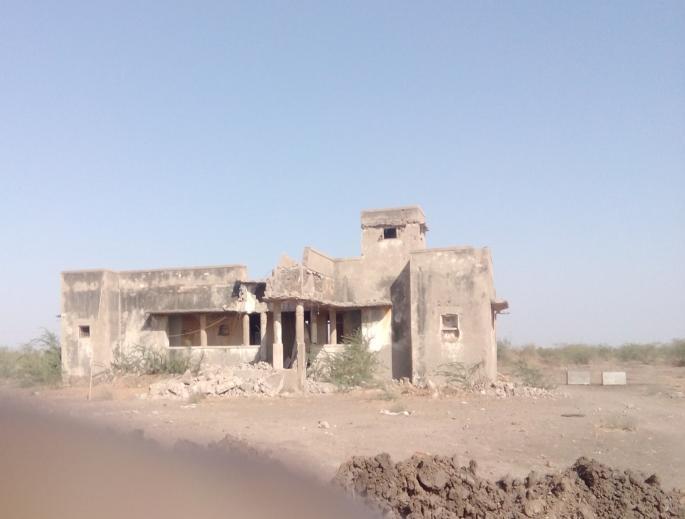
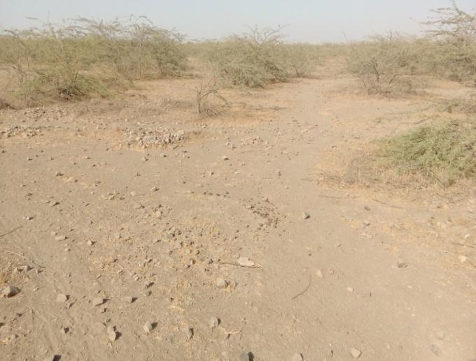
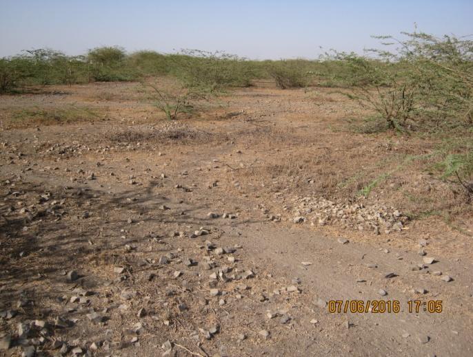

13 MORBI SITE PHOTOGRAPHS 11
Airports Authority of India
 Motihari Airport Bihar Airports Authority of India INDEX Page No 1. About The City..1-3 2. Technical Details 4-8 3. Issued Certificate by Aanchal Adhikari 9 4. Google Earth Pictures...10 5. Site Photographs.11
Katihar Airport Bihar
 Katihar Airport Bihar Airports Authority of India INDEX Page No 1. About The City.1-3 2. Technical Details..4-8 3. Certificate Issued by Officer Incharge, Anchal. 9 4. Google Earth Pictures 10 5. Site
Sitamanu Airport Madhya Pradesh
 Sitamanu Airport Madhya Pradesh Airports Authority of India INDEX Page No 1. About The City.1-3 2. Technical Details..4-8 3. Google Earth Pictures...9 4. Site Photographs..10 5. Site Map.11 6. Obstacle
Karnal Airport Haryana
 Karnal Airport Haryana Airports Authority of India ABOUT THE CITY: ABOUT THE CITY AND AIRPORT CONNECTIVITY NAME OF THE AIRPORT (STATE) : KARNAL AIRPORT, HARYANA (I) INTRODUCTION: Karnal is a city and the
Hosur Airport Tamil Nadu
 Hosur Airport Tamil Nadu Airports Authority of India INDEX Page No 1. About The City.1-2 2. Technical Details..3-8 3. Hosur Aerodrome Published Manual..9-13 4. Google Earth Pictures...14 5. Site Photographs..15
Kanpur (Chakeri-CE) Uttar Pradesh
 Uttar Pradesh") Kanpur (Chakeri-CE) Uttar Pradesh Airports Authority of India ABOUT THE CITY AND AIRPORT CONNECTIVITY NAME OF THE AIRPORT (STATE) : KANPUR (CHAKERI) (CE) (UTTAR PRADESH) ABOUT THE CITY: (I) (II) INTRODUCTION:
Kanpur (Chakeri-CE) Uttar Pradesh Airports Authority of India ABOUT THE CITY AND AIRPORT CONNECTIVITY NAME OF THE AIRPORT (STATE) : KANPUR (CHAKERI) (CE) (UTTAR PRADESH) ABOUT THE CITY: (I) (II) INTRODUCTION:
Gwalior Madhya Pradesh
 Gwalior Madhya Pradesh Airports Authority of India ABOUT THE CITY AND AIRPORT CONNECTIVITY NAME OF THE AIRPORT (STATE) : GWALIOR (MADHYA PRADESH) (I) ABOUT THE CITY: INTRODUCTION: Gwalior is a historic
Kota Airport Rajasthan
 Kota Airport Rajasthan Airports Authority of India ABOUT THE CITY AND AIRPORT CONNECTIVITY NAME OF THE AIRPORT (STATE) : KOTA AIRPORT (RAJASTHAN) (I) ABOUT THE CITY: INTRODUCTION: Kota formerly known as
Madurai Airport Tamil Nadu
 Madurai Airport Tamil Nadu Airports Authority of India ABOUT THE CITY AND AIRPORT CONNECTIVITY NAME OF THE AIRPORT (STATE) : MADURAI AIRPORT (TAMIL NADU) ABOUT THE CITY: (I) INTRODUCTION: Madurai is a
Betul Airport Madhya Pradesh
 Betul Airport Madhya Pradesh Airports Authority of India INEX Page No 1. About The City.1-2 2. Technical etails..3-7 3. Google Earth Pictures...8 4. Site Photographs..9 5. Grid Map 10 6. Approach Rwy 07.11
AD 2. AERODROMES VAKS AD 2.2 AERODROME GEOGRAPHICAL AND ADMINISTRATIVE DATA
 AD 2-1 AD 2. AERODROMES AD 2.1 AERODROME LOCATION INDICATOR AND NAME - KESHOD / DOMESTIC AD 2.2 AERODROME GEOGRAPHICAL AND ADMINISTRATIVE DATA 1 Aerodrome reference point coordinates and its site 2 Direction
AERODROME DATA KESHOD AIRPORT, KESHOD (VAKS)
") TEL: 91-11-24632950 Extn: 2219/2233 AFS: VIDDYXAX FAX: 91-11-24615508 Email: gmais@aai.aero INDIA AERONAUTICAL INFORMATION SERVICE AIRPORTS AUTHORITY OF INDIA RAJIV GANDHI BHAVAN SAFDARJUNG AIRPORT NEW
TEL: 91-11-24632950 Extn: 2219/2233 AFS: VIDDYXAX FAX: 91-11-24615508 Email: gmais@aai.aero INDIA AERONAUTICAL INFORMATION SERVICE AIRPORTS AUTHORITY OF INDIA RAJIV GANDHI BHAVAN SAFDARJUNG AIRPORT NEW
Jammu Airport Jammu & Kashmir
 Jammu Airport Jammu & Kashmir Airports Authority of India ABOUT THE CITY AND AIRPORT CONNECTIVITY NAME OF THE AIRPORT (STATE) : JAMMU (JAMMU & KASHMIR) ABOUT THE CITY: (I) INTRODUCTION: Located on NH-44,
Airports Authority of India
 Beas Airport Punjab Airports Authority of India INEX Page No 1. About The City.1-2 2. Technical etails..3-7 3. Google Earth Pictures...8 4. Site Photographs..9 5. Grid Map 10 6. Close Up View...11 7. Approach
AD 2. AERODROMES VOAT AD 2.2 AERODROME GEOGRAPHICAL AND ADMINISTRATIVE DATA
 AD 2-1 AD 2. AERODROMES AD 2.1 AERODROME LOCATION INDICATOR AND NAME - AGATTI / DOMESTIC AD 2.2 AERODROME GEOGRAPHICAL AND ADMINISTRATIVE DATA 1 Aerodrome reference point coordinates and its site 2 Direction
Therubali Airport Orissa
 Therubali Airport Orissa Airports Authority of India National Register of Airports / Airstrips THERUBALI INEX Page No 1. About The City.1-2 2. Technical etails..3-7 3. Google Earth Pictures...8 4. Site
AIP SUPPLEMENT 01/18 23 MAR18
 PHONE : +94-11- 2264203 FAX : +94-11- 2259916 AFS E-mail : VCBIYHYX VCCCYAYX : aishq@airport.lk ddgasr@caa.lk DEMOCRATIC SOCIALIST REPUBLIC OF SRI LANKA AERONAUTICAL INFORMATION SERVICES (AIS/HQ) AIRPORT
AERODROME DATA GAYA AIRPORT (VEGY)
") TEL: 91-11-24632950 Extn: 2219/2233 AFS: VIDDYXAX FAX: 91-11-24615508 Email: gmais@aai.aero INDIA AERONAUTICAL INFORMATION SERVICE AIRPORTS AUTHORITY OF INDIA RAJIV GANDHI BHAVAN SAFDARJUNG AIRPORT NEW
TEL: 91-11-24632950 Extn: 2219/2233 AFS: VIDDYXAX FAX: 91-11-24615508 Email: gmais@aai.aero INDIA AERONAUTICAL INFORMATION SERVICE AIRPORTS AUTHORITY OF INDIA RAJIV GANDHI BHAVAN SAFDARJUNG AIRPORT NEW
Savitri Jindal Airport Orissa
 Savitri Jindal Airport Orissa Airports Authority of India INEX Page No 1. About The City.1-2 2. Technical etails..3-7 3. Google Earth Pictures...8 4. Site Photographs..9 5. Grid Map 10 6. Close Up View
AD 2. AERODROMES VEBI AD 2.2 AERODROME GEOGRAPHICAL AND ADMINISTRATIVE DATA
 AD 2-1 AD 2. AERODROMES AD 2.1 AERODROME LOCATION INDICATOR AND NAME - BARAPANI / DOMESTIC AD 2.2 AERODROME GEOGRAPHICAL AND ADMINISTRATIVE DATA 1 Aerodrome reference point coordinates and its site 2 Direction
EGSL ANDREWSFIELD EGSL AD 2.1 AERODROME LOCATION INDICATOR AND NAME EGSL AD 2.2 AERODROME GEOGRAPHICAL AND ADMINISTRATIVE DATA
 UNITED KINGDOM AIP AD 2.EGSL-1 26 May 2016 EGSL ANDREWSFIELD EGSL AD 2.1 AERODROME LOCATION INDICATOR AND NAME EGSL ANDREWSFIELD EGSL AD 2.2 AERODROME GEOGRAPHICAL AND ADMINISTRATIVE DATA 1 ARP coordinates
AD 2. AERODROMES VIBR AD 2.2 AERODROME GEOGRAPHICAL AND ADMINISTRATIVE DATA
 AD 2-1 AD 2. AERODROMES AD 2.1 AERODROME LOCATION INDICATOR AND NAME - KULLU MANALI / DOMESTIC AD 2.2 AERODROME GEOGRAPHICAL AND ADMINISTRATIVE DATA 1 Aerodrome reference point coordinates and its site
ARP N W m. Rwy 21 Thr Elev N W. (GUND Elevation 172) 153 M. 853m x 27m.
 153 M. 853m x 27m.") 09 27 UK AIP (28 Jul 11) AD 2-EGPT-2-1 AERODROME CHART - ICAO ARP 562628N 0032226W AD ELEV 397FT PERTH/SCONE EGPT GUND (Geoid Undulation) = The height of the Geoid (MSL) above the Reference Elipsoid (WGS
09 27 UK AIP (28 Jul 11) AD 2-EGPT-2-1 AERODROME CHART - ICAO ARP 562628N 0032226W AD ELEV 397FT PERTH/SCONE EGPT GUND (Geoid Undulation) = The height of the Geoid (MSL) above the Reference Elipsoid (WGS
sd/- DR. GURUPRASAD MOHAPATRA CHAIRMAN AIRPORTS AUTHORITY OF INDIA [EFFECTIVE DATE: 29 MARCH 2018] AERODROME DATA VADODARA AIRPORT (VABO)
![sd/- DR. GURUPRASAD MOHAPATRA CHAIRMAN AIRPORTS AUTHORITY OF INDIA [EFFECTIVE DATE: 29 MARCH 2018] AERODROME DATA VADODARA AIRPORT (VABO)](/thumbs/81/84066110.jpg "sd/- DR. GURUPRASAD MOHAPATRA CHAIRMAN AIRPORTS AUTHORITY OF INDIA [EFFECTIVE DATE: 29 MARCH 2018] AERODROME DATA VADODARA AIRPORT (VABO)") TEL: 91-11-24632950 Extn: 2219/2233 AFS: VIDDYXAX FAX: 91-11-24615508 Email: gmais@aai.aero AIRAC AIP SUPPLEMENT File No. AAI/ATM/AIS/09-09/2018 Following supplement is issued for information, guidance
TEL: 91-11-24632950 Extn: 2219/2233 AFS: VIDDYXAX FAX: 91-11-24615508 Email: gmais@aai.aero AIRAC AIP SUPPLEMENT File No. AAI/ATM/AIS/09-09/2018 Following supplement is issued for information, guidance
ADVISORY CIRCULAR ON CALCULATION OF DECLARED DISTANCES
 Page 1 of 6 1. PURPOSE This Advisory circular (AC) provides guidance to operators to calculated declared distances at aerodrome for safe use of runway and promulgation of aeronautical data to the aeronautical
AD 2. AERODROMES VEBI AD 2.2 AERODROME GEOGRAPHICAL AND ADMINISTRATIVE DATA
 AD 2 VEBI -1 AD 2. AERODROMES VEBI AD 2.1 AERODROME LOCATION INDICATOR AND NAME VEBI - BARAPANI / DOMESTIC VEBI AD 2.2 AERODROME GEOGRAPHICAL AND ADMINISTRATIVE DATA 1 Aerodrome reference point coordinates
AERODROME DATA VIJAYAWADA AIRPORT (VOBZ)
") TEL: 91-11-24632950 Extn: 2219/2233 AFS: VIDDYA FA: 91-11-24615508 Email: gmais@aai.aero AIRAC AIP SUPPLEMENT File No. AAI/ATM/AIS/09-09/2018 Following supplement is issued for information, guidance and
TEL: 91-11-24632950 Extn: 2219/2233 AFS: VIDDYA FA: 91-11-24615508 Email: gmais@aai.aero AIRAC AIP SUPPLEMENT File No. AAI/ATM/AIS/09-09/2018 Following supplement is issued for information, guidance and
Chandigarh Airport Union Territory
 Chandigarh Airport Union Territory Airports Authority of India ABOUT THE CITY AND AIRPORT CONNECTIVITY NAME OF THE AIRPORT (STATE): CHANDIGARH AIRPORT (PUNJAB) ABOUT THE CITY: (I) INTRODUCTION: Chandigarh
PRE FEASIBILITY REPORT TABLE OF CONTENTS
 PRE FEASIBILITY REPORT TABLE OF CONTENTS S. No Particulars Page No. 1 Project Background 33 2 Project Description 33 3 Site Analysis 41 4 Rehabilitation & Resettlement 44 5 Proposed Infrastructure 44 6
AERODROME DATA - SURAT AIRPORT (VASU)
") AIRAC AIP SUPPLEMENT TEL: 91-11-24632950 Extn: 2219/2233 AFS : VIDDYXAX FAX : 91-11-24615508 Email: gmais@aai.aero INDIA AERONAUTICAL INFORMATION SERVICE AIRPORTS AUTHORITY OF INDIA RAJIV GANDHI BHAVAN
AIRAC AIP SUPPLEMENT TEL: 91-11-24632950 Extn: 2219/2233 AFS : VIDDYXAX FAX : 91-11-24615508 Email: gmais@aai.aero INDIA AERONAUTICAL INFORMATION SERVICE AIRPORTS AUTHORITY OF INDIA RAJIV GANDHI BHAVAN
TVSC CANOUAN/Canouan Is. (ST. VINCENT AND THE GRENADINES)
") AIP AD 2. AERODROMES AD 2.921 17 MAY 01 TVSC AD 2.1 AERODROME LOCATION INDICATOR AND NAME TVSC CANOUAN/Canouan Is. (ST. VINCENT AND THE GRENADINES) TVSC AD 2.2 AERODROME GEOGRAPHICAL AND ADMINISTRATIVE
AIP AD 2. AERODROMES AD 2.921 17 MAY 01 TVSC AD 2.1 AERODROME LOCATION INDICATOR AND NAME TVSC CANOUAN/Canouan Is. (ST. VINCENT AND THE GRENADINES) TVSC AD 2.2 AERODROME GEOGRAPHICAL AND ADMINISTRATIVE
Bengaluru / Bangalore Airport Karnataka
 Bengaluru / Bangalore Airport Karnataka Airports Authority of India ABOUT THE CITY AND AIRPORT CONNECTIVITY NAME OF THE AIRPORT (STATE) : (DEVANHALLI / KEMPEGOWDA) INTERNATIONAL AIRPORT, BANGALORE (KARNATAKA)
Aerodrome Geographical and Administration Data
 AIP New Zealand NZDN AD 2 - NZDN AD 2 NZDN AD 2. DUNEDIN NZDN DUNEDIN NZDN AD 2.2 Aerodrome Geographical and Administration Data 2 4 5 6 ARP coordinates and site at AD Direction and distance from (city)
AERODROME DATA TEZU AIRPORT (VETJ)
") AIRAC AIP SUPPLEMENT TEL: 91-11-24632950 Extn: 2219/2233 AFS: VIDDYXAX FAX: 91-11-24615508 Email: gmais@aai.aero INDIA AERONAUTICAL INFORMATION SERVICE AIRPORTS AUTHORITY OF INDIA RAJIV GANDHI BHAVAN SAFDARJUNG
AIRAC AIP SUPPLEMENT TEL: 91-11-24632950 Extn: 2219/2233 AFS: VIDDYXAX FAX: 91-11-24615508 Email: gmais@aai.aero INDIA AERONAUTICAL INFORMATION SERVICE AIRPORTS AUTHORITY OF INDIA RAJIV GANDHI BHAVAN SAFDARJUNG
Kullu- Manali Airport Himachal Pradesh
 Kullu- Manali Airport Himachal Pradesh Airports Authority of India ABOUT THE CITY AND AIRPORT CONNECTIVITY NAME OF THE AIRPORT (STATE) : KULLU MANALI AIRPRORT, BHUNTAR (HIMACHAL PRADESH) ABOUT THE CITY:
AD 2. AERODROMES VOPN AD 2.2 AERODROME GEOGRAPHICAL AND ADMINISTRATIVE DATA
 AD 2-1 AD 2. AERODROMES AD 2.1 AERODROME LOCATION INDICATOR AND NAME - SRI SATHYA SAI / DOMESTIC AD 2.2 AERODROME GEOGRAPHICAL AND ADMINISTRATIVE DATA 1 Aerodrome reference point coordinates and its site
AD 2. AERODROMES VERP AD 2.1 AERODROME LOCATION INDICATOR AND NAME VERP - SWAMI VIVEKANANDA AIRPORT, RAIPUR / DOMESTIC
 AD 2-1 AD 2. AERODROMES AD 2.1 AERODROME LOCATION INDICATOR AND NAME - SWAMI VIVEKANANDA AIRPORT, RUR / DOMESTIC AD 2.2 AERODROME GEOGRAPHICAL AND ADMINISTRATIVE DATA 1 Aerodrome reference point coordinates
TVSU UNION ISLAND/Union Is. (ST. VINCENT AND THE GRENADINES)
") AIP AD 2.951 AD 2. AERODROMES TVSU AD 2.1 AERODROME LOCATION INDICATOR AND NAME TVSU UNION ISLAND/Union Is. (ST. VINCENT AND THE GRENADINES) TVSU AD 2.2 AERODROME GEOGRAPHICAL AND ADMINISTRATIVE DATA 1
AIP AD 2.951 AD 2. AERODROMES TVSU AD 2.1 AERODROME LOCATION INDICATOR AND NAME TVSU UNION ISLAND/Union Is. (ST. VINCENT AND THE GRENADINES) TVSU AD 2.2 AERODROME GEOGRAPHICAL AND ADMINISTRATIVE DATA 1
TVSB BEQUIA IS./J.F. Mitchell (ST. VINCENT AND THE GRENADINES)
") AIP AD 2. AERODROMES AD 2.911 TVSB AD 2.1 AERODROME LOCATION INDICATOR AND NAME TVSB BEQUIA IS./J.F. Mitchell (ST. VINCENT AND THE GRENADINES) TVSB AD 2.2 AERODROME GEOGRAPHICAL AND ADMINISTRATIVE DATA
AIP AD 2. AERODROMES AD 2.911 TVSB AD 2.1 AERODROME LOCATION INDICATOR AND NAME TVSB BEQUIA IS./J.F. Mitchell (ST. VINCENT AND THE GRENADINES) TVSB AD 2.2 AERODROME GEOGRAPHICAL AND ADMINISTRATIVE DATA
AD 2. AERODROMES VIDN AD 2.2 AERODROME GEOGRAPHICAL AND ADMINISTRATIVE DATA
 AD 2 VIDN -1 AD 2. AERODROMES VIDN AD 2.1 AERODROME LOCATION INDICATOR AND NAME VIDN - DEHRADUN / DOMESTIC VIDN AD 2.2 AERODROME GEOGRAPHICAL AND ADMINISTRATIVE DATA 1 Aerodrome reference point coordinates
Airports Authority of India
 Jaipur Rajasthan Airports Authority of India ABOUT THE CITY: ABOUT THE CITY AND AIRPORT CONNECTIVITY NAME OF THE AIRPORT (STATE) : JAIPUR (RAJASTHAN) (I) INTRODUCTION: This famous city is the capital of
AERODROME LICENCE APPLICATION PROCESS
 0000180111 Page 2 Why is a Licence Required? An aerodrome licence is required for a site if it is intended to facilitate operations by commercial transport aircraft, other aerial work other than rotorcraft,
EVTA AD 2.1 AERODROME LOCATION INDICATOR AND NAME EVTA AD 2.2 AERODROME GEOGRAPHICAL AND ADMINISTRATIVE DATA
 18 NOV 2010 AIP LATVIA EVTA AD 2-1 18 NOV 2010 Note: The following sections in this chapter are intentionally left blank: AD-2.11, AD-2.14, AD-2.15, AD-2.16, AD- 2.19, AD-2.20, AD-2.21, AD-2.23 EVTA AD
AERODROME DATA JINDAL VIJAYANAGAR AIRPORT (VOJV)
") TEL: 9--24632950 Extn: 229/2233 AFS: VIDDYXAX FAX: 9--2465508 Email: gmais@aai.aero INDIA AERONAUTICAL INFORMATION SERVICE AIRPORTS AUTHORITY OF INDIA RAJIV GANDHI BHAVAN SAFDARJUNG AIRPORT NEW DELHI 0003
TEL: 9--24632950 Extn: 229/2233 AFS: VIDDYXAX FAX: 9--2465508 Email: gmais@aai.aero INDIA AERONAUTICAL INFORMATION SERVICE AIRPORTS AUTHORITY OF INDIA RAJIV GANDHI BHAVAN SAFDARJUNG AIRPORT NEW DELHI 0003
East Midlands Airport 2018 Aerodrome Manual
 East Midlands Airport 2018 Aerodrome Manual Version 1.0 Not Valid after 31 st December 2018 Department Operations Document Owner Operations Director (Accountable Manager) Document Administrator Ops Development
REPUBLIC OF MALDIVES
 Tel:( +960) 333 7149 ( +960) 333 7250 E-mail: aishq@macl.aero AFTN: VRMMYNYX FAX: (+960) 331 3258 REPUBLIC OF MALDIVES AERONAUTICAL INFORMATION SERVICE AIR TRAFFIC SERVICES Velana International Airport
AD 2-OERY-1 7 JAN 16 OERY AD 2.1 AERODROME LOCATION INDICATOR AND NAME. OERY - RIYADH/ King Salman Air Base
 AD 2-OERY-1 OERY AD 2.1 AERODROME LOCATION INDICATOR AND NAME OERY - RIYADH/ King Salman Air Base OERY AD 2.2 AERODROME GEOGRAPHICAL AND ADMINISTRATIVE DATA 1 ARP coordinates and site at AD 244319N 0464329E/
DRAFT FINAL REPORT AIRPORT MASTER PLAN. Rifle Garfield County Airport Revised May 15, 2014
 DRAFT FINAL REPORT AIRPORT MASTER PLAN Rifle Garfield County Airport Revised May 15, 2014 As required by Paragraph 425.B(4) of FAA Order 5100.38C, Airport Improvement Program (AIP) Handbook: The preparation
Airport Master Plan. Brookings Regional Airport. Runway Runway 17-35
 Runway 17-35 Airport Master Plan Runway 12-30 Brookings Regional Airport Table of Contents Table of Contents Chapter 1: Master Plan Goals... 1-1 1.1. Introduction... 1 1.2. Objective 1 Identify improvements
Aviation Planning in Maine and Our Region. Stacie Haskell Aviation Coordinator & Study Manager Maine Department of Transportation April 27, 2011
 Aviation Planning in Maine and Our Region Stacie Haskell Aviation Coordinator & Study Manager Maine Department of Transportation April 27, 2011 Overview The National Aviation System Maine s Economic Dependence
GCAA ADVISORY CIRCULAR
 GUYANA CIVIL AVIATION AUTHORITY 73 High Street Kingston Georgetown GUYANA TEL. NOs: (592) 225 6822, 225 0778, 227 8111 FAX: (592) 225 6800 E-mail: director-general@gcaa-gy.org GCAA ADVISORY CIRCULAR AERODROME
AD 2-LGPL-1 GREECE 04 JAN 2018 LGPL AD 2.1 AERODROME LOCATION INDICATOR AND NAME LGPL ASTYPALAIA
 AIP AD 2-LGPL-1 GREECE 04 JAN 2018 LGPL AD 2.1 AERODROME LOCATION INDICATOR AND NAME LGPL ASTYPALAIA LGPL AD 2.2 AERODROME GEOGRAPHICAL AND ADMINISTRATIVE DATA 1 ARP coordinates and site at AD 363448N
TANZANIA CIVIL AVIATION AUTHORITY SAFETY REGULATION CHECKLIST FOR SURVEILLANCE INSPECTION OF AERODROMES
 Page 1 of 10 This checklist broadly covers all areas of aerodrome operation, services & facilities. Efforts shall be made to cover areas depending on the time allocated for the inspection and deficiencies
AD 2. AERODROMES VAAU AD 2.2 AERODROME GEOGRAPHICAL AND ADMINISTRATIVE DATA
 AD 2-1 AD 2. AERODROMES AD 2.1 AERODROME LOCATION INDICATOR AND NAME - AURANGABAD / DOMESTIC AD 2.2 AERODROME GEOGRAPHICAL AND ADMINISTRATIVE DATA 1 Aerodrome reference point coordinates and its site 2
Aerodrome Manual. ICAO/FAA Comprehensive Aerodrome Certification Inspector Workshop. Presented To: Caribbean States By: FAA Office of Airports
 ICAO/FAA Comprehensive Aerodrome Certification Inspector Workshop Presented To: Caribbean States By: FAA Office of Airports OBJECTIVE Development of an Aerodrome Manual (AM). 2 ICAO ANNEX 14 - SECTION
EGWN AD 2.1 LOCATION INDICATOR AND NAME EGWN - HALTON EGWN AD AERODROME GEOGRAPHICAL AND ADMINISTRATIVE DATA. 3 5nm SE of Aylesbury
 UK MIL AIP AD 2 - EGWN - 1-1 04 AUG 05 EGWN AD 2.1 LOCATION INDICATOR AND NAME EGWN - EGWN AD 2.2 - AERODROME GEOGRAPHICAL AND ADMINISTRATIVE DATA 1 ARP Co-ordinates and site at AD: 2 Direction and distance
Recent amendment to Annex 14, Volume I and an update on PANS-Aerodromes
 Recent amendment to Annex 14, Volume I and an update on PANS-Aerodromes Yong Wang Chief, Airport Operations and Infrastructure, ICAO Overview Adoption of Amendment 14 to Annex 14, Volume I Update on PANS-Aerodromes
Jabalpur Airport Madhya Pradesh
 Jabalpur Airport Madhya Pradesh Airports Authority of India ABOUT THE CITY AND AIRPORT CONNECTIVITY NAME OF THE AIRPORT (STATE) : JABALPUR AIRPORT (MADHYA PRADESH) ABOUT THE CITY: (I) INTRODUCTION: Jabalpur
AD 2-OEWJ-1 14 SEP 17 OEWJ AD 2.1 AERODROME LOCATION INDICATOR AND NAME. OEWJ - WEJH / (Domestic)
") AIP AD 2-OEWJ-1 14 SEP 17 OEWJ AD 2.1 AERODROME LOCATION INDICATOR AND NAME OEWJ - WEJH / (Domestic) OEWJ AD 2.2 AERODROME GEOGRAPHICAL AND ADMINISTRATIVE DATA 1 ARP coordinates and site at AD 261155N
AIP AD 2-OEWJ-1 14 SEP 17 OEWJ AD 2.1 AERODROME LOCATION INDICATOR AND NAME OEWJ - WEJH / (Domestic) OEWJ AD 2.2 AERODROME GEOGRAPHICAL AND ADMINISTRATIVE DATA 1 ARP coordinates and site at AD 261155N
SIMULATION USE ONLY. DO NOT USE FOR REAL WORLD NAVIGATION N IVAO HONG KONG
 53 52 51 50 H1 E1 60 MAINTENANCE APRON E 59 E1 61 F 58 EAST APRON 49 48 H1 G 57 55 56 H1 54 H 47 46 45 44 43 41 CARGO APRON SIMULATION USE ONLY. DO NOT USE FOR REAL WORLD NAVIGATION. 22 19 02 N AERODROME
AD 2-LGSO-1 GREECE 04 JAN 2018 GSO AD 2.1 AERODROME LOCATION INDICATOR AND NAME LGSO SYROS / DIMITRIOS VIKELAS
 AD 2-LGSO-1 GREECE 04 JAN 2018 GSO AD 2.1 AERODROME LOCATION INDICATOR AND NAME LGSO SYROS / DIMITRIOS VIKELAS LGSO AD 2.2 AERODROME GEOGRAPHICAL AND ADMINISTRATIVE DATA 1 ARP coordinates and site at AD
ICAO Recommended Airport Signs, Runway And Taxiway Markings. COPYRIGHT JEPPESEN SANDERSON, INC., ALL RIGHTS RESERVED. Revision Date:
 ICAO Recommended Airport Signs, Runway And Taxiway Markings Revision Date: 20051230 MANDATORY INSTRUCTION SIGNS A mandatory instruction sign identifies a location beyond which an aircraft taxiing shall
Session. Arrester Systems, Declared Distances and Runway Excursion Prevention
 Session Arrester Systems, Declared Distances and Runway Excursion Prevention 1 Runway Excursion Toronto, Canada August 2, 2005 200 meters from end of runway 2 American Airlines Flight 331, Norman Manley
AERODROME MANUAL. (name) AIRPORT
 AIRPORT") AERODROME MANUAL (name) AIRPORT (MM/YYYY) () (FIRST PUBLISHED IN 1999) Airport Certificate The airport certificate will be found on the next page. Amendment date: 06/2008 (Airport Operator Name) Page 2
AERODROME MANUAL (name) AIRPORT (MM/YYYY) () (FIRST PUBLISHED IN 1999) Airport Certificate The airport certificate will be found on the next page. Amendment date: 06/2008 (Airport Operator Name) Page 2
EIA for Development of New Civil Enclave at Air Force Base. Annexure 2
 EIA for Development of New Civil Enclave at Air Force Base at Bamrauli, Allahabad, Uttar Pradesh Public Hearing Details Annexure 2 Details of Public Hearing for Development of New Civil Enclave at Air
OJAI AD 2.3 JORDAN 01 AUG 2009
 AIP AD 2.1 JORDAN 01 AUG 2009 OJAI AD 2.1 AERODROME LOCATION INDICATOR AND NAME OJAI - Queen Alia International OJAI AD 2.2 AERODROME GEOGRAPHICAL AND ADMINISTRATIVE DATA 1 ARP coordinates and site at
TO SAFETY REGULATION DIVISION NR T.04 AVIATION HOUSE HAWKINS STREET. DUBLIN 2 Tel Fax AFTN EIDWYOYX
 NOTICE IRELAND TO SAFETY REGULATION DIVISION NR T.04 AERODROME IRISH AVIATION AUTHORITY ISSUE 4 AVIATION HOUSE LICENCE DATE 15.12.09 HAWKINS STREET HOLDERS DUBLIN 2 Tel +353 1 6718655 Fax +353 1 6774068
Inaugurated on 18 th March 2013
 W Inaugurated on 18 th March 2013 Location of Mattala Mattala Rajapaksa International Airport is an international airport serving the city of Hambantota in southeast Sri Lanka. Tourist attractions, such
AERODROME MARKINGS AND SIGNALIZATION
 1. Introduction AERODROME MARKINGS AND SIGNALIZATION This article will present the main aerodrome markings and signalization on runways and taxiways. 2. Runway Markings This chapter will show the runway
AD 2-OEHL-1 23 JUN 16 OEHL AD 2.1 AERODROME LOCATION INDICATOR AND NAME. OEHL - HAIL / Hail (Regional)
") AIP AD 2-OEHL-1 23 JUN 16 OEHL AD 2.1 AERODROME LOCATION INDICATOR AND NAME OEHL - HAIL / Hail (Regional) OEHL AD 2.2 AERODROME GEOGRAPHICAL AND ADMINISTRATIVE DATA 1 ARP coordinates and site at AD 272623N
AIP AD 2-OEHL-1 23 JUN 16 OEHL AD 2.1 AERODROME LOCATION INDICATOR AND NAME OEHL - HAIL / Hail (Regional) OEHL AD 2.2 AERODROME GEOGRAPHICAL AND ADMINISTRATIVE DATA 1 ARP coordinates and site at AD 272623N
BELFAST MUNICIPAL AIRPORT OVERVIEW
 BELFAST MUNICIPAL AIRPORT OVERVIEW LOCATION AND HISTORY Belfast Municipal Airport (Federal Aviation Administration (FAA) airport code BST, International Civil Aviation Organization airport code KBST, FAA
AD 2-LGST-1 GREECE 19 JUL 2018 LGST AD 2.1 AERODROME LOCATION INDICATOR AND NAME LGST SITIA/VITSENTZOS KORNAROS
 AD 2-LGST-1 GREECE 19 JUL 2018 LGST AD 2.1 AERODROME LOCATION INDICATOR AND NAME LGST SITIA/VITSENTZOS KORNAROS LGST AD 2.2 AERODROME GEOGRAPHICAL AND ADMINISTRATIVE DATA 1 ARP coordinates and site at
AERODROME ADVISORY CIRCULAR
 GOVERNMENT OF INDIA CIVIL AVIATION DEPARTMENT OFFICE OF THE DIRECTOR GENERAL OF CIVIL AVIATION AD AC NO. 1 of 2006 14 th Sept.2006 AERODROME ADVISORY CIRCULAR SUBJECT: GUIDELINES FOR PREPARATION & MAINTENANCE
ICAO Aerodrome s Manual. AERODROME S INSPECTOR WORKSHOP St. Maarten, MAHO June 2012
 ICAO Aerodrome s Manual AERODROME S INSPECTOR WORKSHOP St. Maarten, MAHO 11-15 June 2012 Objectives - Identify the requirements listed in Annex 14 regarding the development and maintenance of an aerodrome
Safdarjung Airport Delhi
 Safdarjung Airport Delhi Airports Authority of India ABOUTTHECITY: ABOUT THE CITY AND AIRPORT CONNECTIVITY NAME OF THE AIRPORT(STATE) : SAFDARJUNG AIRPORT (DELHI) (I) INTRODUCTION: Safdarjung Area is located
DEPARTMENT: CIVIL ENGINEERING SEMESTER: III SUBJECT CODE / Name: CE2303/ Railway, Airport and Harbors Engineering 2 MARK QUESTIONS AND ANSWERS
 DEPARTMENT: CIVIL ENGINEERING SEMESTER: III SUBJECT CODE / Name: CE2303/ Railway, Airport and Harbors Engineering 2 MARK QUESTIONS AND ANSWERS 1.Define wind Coverage (AUC NOV/DEC 2010),(AUC NOV/DEC 2011)
ZANZIBAR AIRPORTS AUTHORITY PROJECTS
 ZANZIBAR AIRPORTS AUTHORITY PROJECTS ZANZIBAR AIRPORTS AUTHORITY INTRODUCTION Zanzibar is a part of United Republic of Tanzania It consists of two main Islands, Unguja and Pemba, and several other smaller
ERIE INTERNATIONAL AIRPORT MASTER PLAN TABLE OF CONTENTS
 EXECUTIVE SUMMARY ERIE INTERNATIONAL AIRPORT MASTER PLAN TABLE OF CONTENTS PAGE NO. CHAPTER 1-INTRODUCTION... 1-1 1.01 General...1-1 1.02 Purpose and Scope of Study...1-1 1.03 The Planning Process...1-2
PREDANNACK AD LOCATION INDICATOR AND NAME PREDANNACK PREDANNACK AD AERODROME GEOGRAPHICAL AND ADMINISTRATIVE DATA. 2nm SE of Mullion.
 AD 2 - - 1-1 AD 2.1 - LOCATION INDICATOR AND NAME AD 2.2 - AERODROME GEOGRAPHICAL AND ADMINISTRATIVE DATA 1 ARP Co-ordinates and site at AD: 2 Direction and distance from City: 3 Elevation/Reference Temperature:
AERODROME LOCATION INDICATOR AND NAME VNKT - TRIBHUVAN/International AERODROME GEOGRAPHICAL AND ADMINISTRATIVE DATA
 AIP VNKT AD 2-1 AD 2. AERODROME VNKT AD 2.1 AERODROME LOCATION INDICATOR AND NAME VNKT - TRIBHUVAN/International VNKT AD 2.2 AERODROME GEOGRAPHICAL AND ADMINISTRATIVE DATA 1. ARP Coordinates and site at
Chippewa-Eau Claire Metropolitan Planning Area Long Range Transportation Plan
 1.2.7 2010 Eau Claire County Comprehensive Plan According to Eau Claire County s most recent comprehensive plan, the County will limit land use development adjacent to EAU in order to preserve the ability
AD 2. AERODROMES VAID AD 2.2 AERODROME GEOGRAPHICAL AND ADMINISTRATIVE DATA
 AD 2-1 AD 2. AERODROMES AD 2.1 AERODROME LOCATION INDICATOR AND NAME - INDORE / DOMESTIC AD 2.2 AERODROME GEOGRAPHICAL AND ADMINISTRATIVE DATA 1 Aerodrome reference point coordinates and its site 2 Direction
Major Runway/Taxiway Maintenance Work Bangalore International Airport (Devanahalli) (08 MAR 2012 TO 04 MAY 2012)
 (08 MAR 2012 TO 04 MAY 2012)") AIRAC AIP SUPPLEMENT TEL: 91-11-24632950 Extn: 2219/2233 AFS : VIDDYXAX FAX : 91-11-24615508 Email: gmais@aai.aero INDIA AERONAUTICAL INFORMATION SERVICE AIRPORTS AUTHORITY OF INDIA RAJIV GANDHI BHAVAN
AIRAC AIP SUPPLEMENT TEL: 91-11-24632950 Extn: 2219/2233 AFS : VIDDYXAX FAX : 91-11-24615508 Email: gmais@aai.aero INDIA AERONAUTICAL INFORMATION SERVICE AIRPORTS AUTHORITY OF INDIA RAJIV GANDHI BHAVAN
Consideration will be given to other methods of compliance which may be presented to the Authority.
 Advisory Circular AC 139-9 Notification of aerodrome data and information Revision 2 27 April 2007 General Civil Aviation Authority advisory circulars (AC) contain information about standards, practices
Acronyms. Airport Layout Plan Report Appendix A A-1
 Appendix A Acronyms AC... Advisory Circular ADG... Airplane Design Group ADO... Airport District Office AGL... Above Ground Level AIM... Aeronautical Information Manual AIP... Airport Improvement Program
TLPC CASTRIES/George F. Charles (ST. LUCIA)
") AIP EASTERN CARIBBEAN AD 2. AERODROMES AD 2.8-1-1 17 MAY 01 TLPC AD 2.1 AERODROME LOCATION INDICATOR AND NAME TLPC CASTRIES/George F. Charles (ST. LUCIA) TLPC AD 2.2 AERODROME GEOGRAPHICAL AND ADMINISTRATIVE
AIP EASTERN CARIBBEAN AD 2. AERODROMES AD 2.8-1-1 17 MAY 01 TLPC AD 2.1 AERODROME LOCATION INDICATOR AND NAME TLPC CASTRIES/George F. Charles (ST. LUCIA) TLPC AD 2.2 AERODROME GEOGRAPHICAL AND ADMINISTRATIVE
(a) it has been licensed for the purpose, and save in accordance with the conditions prescribed in such licence; or
 it has been licensed for the purpose, and save in accordance with the conditions prescribed in such licence; or") PART - XI Aerodromes 78. Licensing of Aerodromes (1) No aerodrome shall be used as a regular place of landing and departure by a scheduled air transport service or for a series of landings and departures
PART - XI Aerodromes 78. Licensing of Aerodromes (1) No aerodrome shall be used as a regular place of landing and departure by a scheduled air transport service or for a series of landings and departures
Table of Contents. Overview Objectives Key Issues Process...1-3
 Table of Contents Chapter One Introduction Overview...1-1 Objectives...1-1 Key Issues...1-2 Process...1-3 Chapter Two Inventory of Existing Conditions Airport Setting...2-1 Locale...2-1 Airport Surroundings...2-5
AD 2-OEAB-1 2 AUG 15 OEAB AD 2.1 AERODROME LOCATION INDICATOR AND NAME. OEAB - ABHA / Abha (Regional)
") AIP AD 2-OEAB-1 2 AUG 15 OEAB AD 2.1 AERODROME LOCATION INDICATOR AND NAME OEAB - ABHA / Abha (Regional) OEAB AD 2.2 AERODROME GEOGRAPHICAL AND ADMINISTRATIVE DATA 1 ARP coordinates and site at AD 181425N
AIP AD 2-OEAB-1 2 AUG 15 OEAB AD 2.1 AERODROME LOCATION INDICATOR AND NAME OEAB - ABHA / Abha (Regional) OEAB AD 2.2 AERODROME GEOGRAPHICAL AND ADMINISTRATIVE DATA 1 ARP coordinates and site at AD 181425N
Establishing a new Aerodrome/Heliport in the AIPNZ
 Establishing a new Aerodrome/Heliport in the AIPNZ The Aeronautical Information Management (AIM) unit of Airways are responsible for publishing new aerodromes and heliports in the AIPNZ. Applicants are
GLOSSARY A.1 ABBREVIATIONS/ACRONYMS
 Appendices Glossary A A GLOSSARY A.1 ABBREVIATIONS/ACRONYMS AC ADF ADPM AGL AIP ALP ALS ALSF-1 ARC ARFF ARP ARTCC ASDA ASO ASR ASV ATC ATCT AVGAS BLI CBP CIP - Advisory Circular - Automatic Direction
CIVIL AVIATION REQUIREMENTS SECTION 4 AERODROME STANDARDS & LICENSING SERIES 'B' PART VI 22 ND MARCH 2012 EFFECTIVE: FORTHWITH
 GOVERNMENT OF INDIA OFFICE OF DIRECTOR GENERAL OF CIVIL AVIATION TECHNICAL CENTRE, OPP SAFDARJANG AIRPORT, NEW DELHI CIVIL AVIATION REQUIREMENTS SECTION 4 AERODROME STANDARDS & LICENSING SERIES 'B' PART
CIVIL AVIATION ACT (Act No. 11 of 2011) CIVIL AVIATION (AERODROMES) REGULATIONS, 2012 (Published on 28th December, 2012) ARRANGEMENT OF REGULATIONS
 CIVIL AVIATION (AERODROMES) REGULATIONS, 2012 (Published on 28th December, 2012) ARRANGEMENT OF REGULATIONS") Supplement C Botswana Government Gazette dated 28th December, 2012 C.925 Statutory Instrument No. 101 of 2012 CIVIL AVIATION ACT (Act No. 11 of 2011) CIVIL AVIATION (AERODROMES) REGULATIONS, 2012 (Published
Supplement C Botswana Government Gazette dated 28th December, 2012 C.925 Statutory Instrument No. 101 of 2012 CIVIL AVIATION ACT (Act No. 11 of 2011) CIVIL AVIATION (AERODROMES) REGULATIONS, 2012 (Published
BOTTLANG AIRFIELD MANUAL
 Airway Manual Services & Flight Information Jeppesen GmbH BOTTLANG AIRFIELD MANUAL P.O. Box 1535 Tel.: +49 6102 5070 63235 Neu-Isenburg Fax: +49 6102 507547 GERMANY e-mail: fra-services@jeppesen.com Dear
AD 2-OEGN-1 20 JUL 17 OEGN AD 2.1 AERODROME LOCATION INDICATOR AND NAME. OEGN - JAZAN / King Abdullah Bin Abdulaziz (Regional)
") AIP AD 2-OEGN-1 OEGN AD 2.1 AERODROME LOCATION INDICATOR AND NAME OEGN - JAZAN / King Abdullah Bin Abdulaziz (Regional) OEGN AD 2.2 AERODROME GEOGRAPHICAL AND ADMINISTRATIVE DATA 1 ARP coordinates and
AIP AD 2-OEGN-1 OEGN AD 2.1 AERODROME LOCATION INDICATOR AND NAME OEGN - JAZAN / King Abdullah Bin Abdulaziz (Regional) OEGN AD 2.2 AERODROME GEOGRAPHICAL AND ADMINISTRATIVE DATA 1 ARP coordinates and
EVVA AD 2.1 AERODROME LOCATION INDICATOR AND NAME EVVA AD 2.2 AERODROME GEOGRAPHICAL AND ADMINISTRATIVE DATA
 AIP LATVIA EVVA AD 2-1 Note: The following sections in this chapter are intentionally left blank: AD-2.7, AD-2.16, AD-2.19, AD-2.23 EVVA - VENTSPILS EVVA AD 2.1 AERODROME LOCATION INDICATOR AND NAME EVVA
Rebuilding Plan For Mosul International Airport
 Rebuilding Plan For Mosul International Airport Contents Part- 1 General Information About Mosul International Airport (MIA) Before 2014 Part -2 Brief Description to Current Situation Part -2 Reconstruction
LRSB AD 2.1 AERODROME LOCATION INDICATOR AND NAME LRSB - SIBIU / Sibiu
 AIP AD 2.131 02 MAY 2013 LRSB AD 2.1 AERODROME LOCATION INDICATOR AND NAME LRSB SIBIU / Sibiu LRSB AD 2.2 AERODROME GEOGRAPHICAL AND ADMINISTRATIVE DATA 1 ARP coordinates and site at AD 454709N 0240508E
EGUY AD LOCATION INDICATOR AND NAME EGUY - WYTON EGUY AD AERODROME GEOGRAPHICAL AND ADMINISTRATIVE DATA. 3nm NE of Huntingdon. 135ft/22 C.
 AD 2 - EGUY - 1-1 06 JUL 06 EGUY AD 2.1 - LOCATION INDICATOR AND NAME EGUY - EGUY AD 2.2 - AERODROME GEOGRAPHICAL AND ADMINISTRATIVE DATA 1 ARP Co-ordinates and site at AD: 2 Direction and distance from
Rodrigues Regional Assembly Chief Commissioner s Office
 Ref: CCO/CAV/1/2013 Rodrigues Regional Assembly Invitation for Expressions of Interest Consultancy Services for the Design of Runway Extension & Ancillary Works at Sir Gaetan Duval Airport Plaine Corail,Rodrigues