Start. Directions. Finish at Perran Sands Holiday Park
|
|
|
- Marianna Hamilton
- 5 years ago
- Views:
Transcription


1


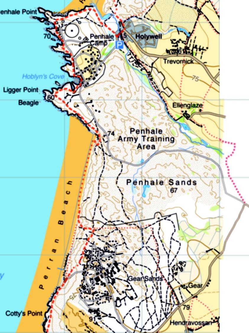
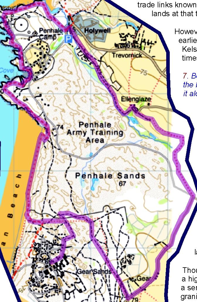
2 Directions 1. Take the 587 bus towards Newquay from the bus stop at Perran Sands entrance and get off at Crantock. Head down Halwyn Hill to the square and turn left down Green Lane to take the footpath on your left, forking left again to walk to the South West Coast Path, above Crantock Beach. 2. Reaching the South West Coast Path, turn left and follow it around Pentire Point West and on to Porth Joke ('Polly Joke' as it is known to the locals). 'Porth Joke' comes from the Cornish 'Porth Lojowek', meaning 'cove rich in plants'. Traditional conservation techniques used here have encouraged an astonishing 154 species of wildflower to flourish. In a ne wyn Hal Start 3. Carry on along the Coast Path as it continues around Kelsey Head and drops into the dunes behind Holywell Beach to come out by the first houses in Holywell. Kelsey Head is a Site of Special Scientific Interest with a wide range of habitats, the most extensive being the sand dune system and the maritime grassland which has grown over wind-blown sand around the fringes of the headlands and on Cubert Common. Other important wildlife areas are the wet meadows alongside the stream as you walk to Porth Joke and the brackish marsh at Holywell Bay. rveymaps.co.uk RVEY Base mapping HA Listen out for the Gannel crake, a mythical bird whose desolate howl has been heard all around Crantock Beach. The name is attributed to two brothers who were once working beneath West Pentire, gathering seaweed to use as fertiliser. One of the brothers described the sound, which frightened their horses into galloping away, as 'like a thousand voices in pent-up misery with one long-drawn wail dying away into the distance. nl Hi l l Gre e Crantock is said to be the site of the Lost City of Langarrow, buried by a sandstorm after the hedonistic lifestyle of its inhabitants brought the wrath of God upon their heads. It is named after the sixth century Celtic saint, Carantoc, who supposedly arrived by sea on an altar and built an oratory here. This blossomed into a College of Priests, a major religious centre until it was dismantled under Henry VIII's Dissolution of Monasteries in the sixteenth century. The 'Round Orchard' in the centre of the village is thought to be the site of St Carantoc's sixth century chapel. There are also two medieval holy wells in the village. On the far side of Crantock Beach is the mouth of the River Gannel. In the fifteenth century the mouth of the River Gannel was a thriving port, and until as late as the end of the nineteenth century it was used extensively by shipping. Vessels brought their cargoes of coal, fertiliser, limestone and earthenware into Fern Pit on the Newquay bank of the river. This was then transferred to shallow-draught barges to be carried on the flood tide up to Trevemper, an important commercial centre three miles upstream. summer the headland is ablaze with the vivid heads of poppies and corn marigolds, also providing seeds for birds like buntings, partridge and finches. River Ga nnel A number of rare plants grow around here, including sea holly in the sand dunes and Babington's leek in the area of marshland. The particularly unusual and beautiful silverstudded blue butterfly has also been seen at Kelsey Head, and the stripe-winged grasshopper spotted here is one of only three sightings in Devon and Cornwall in recent years. The headland and the offshore islands are also noteworthy for the colonies of breeding seabirds including guillemots, shags and razorbills. The small island just offshore as you round the headland is known as The Chick. Look out for grey seals here, especially at low tide. Sometimes dolphins can be seen too. Finish at Perran Sands Holiday Park Evidence of human activity has been found around Kelsey Head dating back to Mesolithic (Middle Stone Age) times, around BC. There are also tumuli, or burial barrows, dating from the Bronze Age, around 3000 BC, and archaeologists have identified two Iron Age cliff castles here.


3


4


5


 was one of Cornwall's busiest mining areas, employing up to 1000 men miners underground while their wives and children")


6 Directions In 1915/6, however, an unrepaired gap in the harbour wall led to its being demolished during a great storm, and now only the granite blocks around the cove remain of what was a busy port. 1. Take the 403 bus from the entrance of Perran Sands Holiday Park. It stops in St Agnes on Vicarage Road at the Institute. From there walk down 1.Vicarage Road, turning right onto 2.Town Hill and then left down 3.Stippy Stappy Lane to 4.Quay Road. Take the 5.footpath opposite and follow it as it climbs gently through the valley to join the South West Coast Path high above Trevaunance Cove. Turn right here, towards Perranporth, and follow the path along the top of the cliffs. From the sixteenth century until the 1920s, St Agnes ('Breanek' in Cornish) was one of Cornwall's busiest mining areas, employing up to 1000 men miners underground while their wives and children worked on the surface. Much of the World Heritage Site, the Cornwall and West Devon Mining Landscape, is in the parish. 5 The ore was shipped from St Agnes harbour, on the west side of Trevaunance Cove. 3 4 It was dropped down a chute from the ore 1 2 bins, which are still visible on the cliffs above. Imported coal was raised to the clifftop mines by means of a horse whim - a round platform where a horse would be led around a Pen a Grader winch. Blue Hills Town Golf Course 2. The path drops steeply to the road at Blue Hills. Turn left here and pick up the Coast Path again as it travels seawards, climbing gently above the stream and then turning to climb steeply to the top of the hill. This area is known as Jericho Valley, and for over a hundred years the steep roads by the Blue Hills tin works have been host to the Land's End Classic Trial, a motor race held every Easter, running from London to Land's End. Blue Hills is Cornwall's last tin stream works and still produces small quantities of tin today. The tin produced at Blue Hills is gathered along the coastline, having been mined by the sea and washed by the waves. This alluvial tin mining is a process that was exploited as long ago as 2000 BC, during the Bronze Age, and it led to links with traders from the Mediterranean as well as with communities across the English Channel. When the price of tin was high and the mines were producing large quantities, the prosperity would be celebrated with bunting and brass bands; but when the price slumped and the mines started to close, many of the miners emigrated in search of work, leading to the adage, 'Wherever there's a hole in the ground, you'll find a Cornish miner!' Mining was a dangerous occupation, and it led to strong community bonds. A Cornish miner working in South Africa in the last century told of one of his most moving memories of his early days in the Wheal Kitty mine at St Agnes. Quay Road There were many attempts to build a harbour at Trevaunance Cove, four of which, between 1632 and 1709, left the local lords of the manor deeply in debt. Another, built in 1710, was washed away in It was not until 1798 that a harbour was finally constructed which withstood the rigours of the sea. As well as the trade linked with mining, a pilchard fishing industry was established early in the nineteenth century, although it started to decline after only 30 years. Finish at Perran Sands Holiday Park The picturesque terrace of houses in Stippy Stappy Lane was built in the eighteenth century for ships' captains. The whole terrace, as well as its garden walls, is classed as a listed building. Hill Start Base mapping HARVEY As the miners gathered at the shaft at the end of their shift, waiting to be raised to the surface, someone began to sing. The others around him joined in, and then the song was taken up by miners waiting at stations higher up the shaft, so that the whole mine echoed with the sound of the singing. Cornish male voice choirs were as powerful as their Welsh equivalent, and both were an expression of the miners' ability to enjoy the good things in life despite its hardships.


7


8


9

10
CORNWALL AND ISLES OF SCILLY LANDSCAPE CHARACTER STUDY
 LCA - Newquay and Perranporth Coast LCA No CA15 JCA Constituent LDUs Total 32: 6, 8, 9, 10, 11, 12, 13, 14, 15, 25, 76, 77, 78, 115, 116, 117, 118, 175, 176, 177U, 178, 296, 343, 344, 346, 347, 348, 349U,
Cormorant and Guillemot WEST PENTIRE CRANTOCK CORNWALL
 and WEST PENTIRE CRANTOCK CORNWALL Nearby Crantock Bay (view not from property) and West Pentire Crantock Cornwall TR8 5SE Fabulous coastal property with a two bedroom annexe overlooking Crantock Bay
Pendeen Ten Thousand Years of History
 Pendeen Ten Thousand Years of History Geevor On first sight, the village of Pendeen seems to be a product of 19 th century mining, it has in fact a long and complex history rich in archaeological and other
Halesowen B62 9RQ. After walking through the private garden, your entrance is preceded by the sun lounge/conservatory; a particularly
 Brochure Correspondence Address: 15 Willowsbrook Road Halesowen West Midlands B62 9RQ Tel: 0121 422 7556 was stone built during the 17th Century and sits in the tranquil, picturesque and unspoilt village
North Meadow National Nature Reserve
 Leaflet produced with the support of Cricklade Town Council. North Meadow National Nature Reserve For further information about North Meadow contact: The Senior Reserve Manager The Ebworth Centre, The
Ref: LCAA ,000. Dale Cottage, Beach Road, Crantock, Newquay, Cornwall
 445,000 Dale Cottage, Beach Road, Crantock, Newquay, Cornwall FREEHOLD A charming and sensitively modernised 4 bedroomed, 2 bathroomed three storey semidetached period house in the heart of Crantock close
A Circular Walk from Chapel Carn Brea
 A Circular Walk from Chapel Carn Brea 4.3 Miles A Walk Visiting Five Historic Ancient Sites This circular walk offers the possibility of several alternatives, depending on the walker s available time and
Access: The rocky shoreline is only accessible via private property.
 10. Whale Cove Site description: Whale Cove is a small cove fringed by private homes and condominiums with diverse and relatively undisturbed rocky intertidal and subtidal habitat located approximately
Site description: 2.7 miles of intertidal habitat located about 2 miles north of Depoe Bay in Lincoln County, Oregon (Figure 16).
.") 8 Boiler Bay Site description: 27 miles of intertidal habitat located about 2 miles north of Depoe Bay in Lincoln County, Oregon (Figure 16) Designation: Boiler Bay was a research reserve before TSP publication,
8 Boiler Bay Site description: 27 miles of intertidal habitat located about 2 miles north of Depoe Bay in Lincoln County, Oregon (Figure 16) Designation: Boiler Bay was a research reserve before TSP publication,
Eglwyseg Mountain a landscape of prehistoric cairns and later industry
 Eglwyseg Mountain a landscape of prehistoric cairns and later industry Walk Information: Maps: OS Explorer 256 Distance: 5.3 miles / 8.5 kilometres (linear) or up to 9.6 miles / 15.5 kilometres (circular)
Crimdon. A walk of nature...sea, sand and countryside
 Crimdon A walk of nature......sea, sand and countryside A182 B1283 A181 Wingate B1287 Peterlee Seaham Easington B1281 Newcastle Horden Blackhall A179 Newcastle International Airport Crimdon A1086 Location...
Britain s oldest surviving water-balanced cliff lift
 44 3.6 Saltburn by the Sea to Sandsend Map panels 3 and 4 Distance 17 miles (27½ km) Terrain mostly grass and field paths which can be muddy; some pavement, beach and shore Grade undulating route, with
Silver-washed Fritillaries in the Straits Inclosure in July
 ALICE HOLT FOREST Hampshire from www.discoverbutterflies.com the website for the book Discover Butterflies in Britain D E Newland Silver-washed Fritillaries in the Straits Inclosure in July Alice Holt
Hadleigh Castle and Chalkwell Oaze
 1 Hadleigh Castle and Chalkwell Oaze Benfleet station Hadleigh Park Hadleigh Castle Leigh-on-Sea Chalkwell station A short stroll through the lush woods of Hadleigh Park high above the Thames-side marshes,
U3A WTT Bagworth. Route Summary. Route Overview. Description. Waypoints. Sculpture. Stuart Galloway. A circular walk around Bagworth.
 U3A WTT Bagworth Stuart Galloway Route Summary A circular walk around Bagworth. Route Overview Category: Walking Length: 6.450 km / 4.03 mi Parking: Bagworth Heath Date Published: 27th April 2016 Difficulty:
Death Valley Is a Beautiful but Dangerous Place
 Death Valley Is a Beautiful but Dangerous Place Welcome to This Is America with VOA Learning English. Today we visit one of America s great national parks. It is a place of strange and silent beauty. As
F.O.K.O.S. Friends of Kingston Open Space A GUIDE TO KINGSTON OPEN SPACE
 F.O.K.O.S. Friends of Kingston Open Space A GUIDE TO KINGSTON OPEN SPACE Friends of Kingston Open Space (FOKOS) was formed when a handful of concerned citizens joined together to learn what could be done
Jersey International Motoring Festival 2016
 Jersey International Motoring Festival 2016 Enjoy a Wonderful 5 or 7 Day Tour to the Channel Islands for the 2016 Jersey International Motoring Festival! Jersey Sparkling Seas, golden sands, rugged cliffs,
Bridgetown. O Briensbridge. Knockadrohid. Ardataggle. Fairyhall. Cappakea. Montpelier. Derryhasna. Aughboy. Drummeen Kildoorus.
 Bridgetown Knockadrohid O Briensbridge had been on the main water- road from Limerick to Dublin from 1799 until the last trading boat passed through in June 1929 From the late eighteenth century it was
RIVIERA LINE E X E T E R PAIGNTON
 RIVIERA LINE EXETER PAIGNTON Supported by Introduction The Riviera Line offers great scenic train journeys along the South Devon coast between Exeter and Paignton. The train is an ideal way to enjoy a
SIXTH GRADE SCHOOL TOURS AT THE HACKETT HOUSE - CARLOW, IRELAND
 SIXTH GRADE SCHOOL TOURS AT THE HACKETT HOUSE - CARLOW, IRELAND The presentation will cover timelines and historical information as it fits: Performance Objectives covered: Construct timelines of the historical
2.0 PARK VISION AND ROLES
 2.0 PARK VISION AND ROLES 2.1 Significance in the Protected Area System Marble Range and Edge Hills provincial parks protect 6.8% of the Pavillion Ranges Ecosection, which is located in the Southern Interior
Coast Path Survey Stretch 09 Shalfleet Mill to Thorness Bay
 Coast Path Survey Stretch 09 Shalfleet Mill to Thorness Bay Overview Map of stretch Introduction This stretch of Island coast covers several salt marsh creeks backed by grazing land and woodland on the
Pick a Box Game 1. a green I see story as. at be and story number and. green a number at as see. and story as green be I. I see be and at number
 Pick a Box Game 1 a green I see story as at be and story number and green a number at as see and story as green be I I see be and at number Pick a Box Game 2 like one we the or an or an like said of it
Holywell Road Cubert. A high quality development of 2, 3 and 4 bedroomed homes situated in the picturesque Cornish village of Cubert.
 Parc an Rose Holywell Road Cubert A high quality development of 2, 3 and 4 bedroomed homes situated in the picturesque Cornish village of Cubert Holywell Bay Around Cubert Situated on the edge of the delightful
Ref: LCAA6743- LCAA ,000 to 695,000. Wheal Turnavore, West Polberro, St Agnes, Nr. Truro, Cornwall
 Ref: LCAA6743- LCAA6747 595,000 to 695,000 Wheal Turnavore, West Polberro, St Agnes, Nr. Truro, Cornwall FREEHOLD An unparalleled contemporary development of just 6 exceptional architecturally inspiring
Beautiful Walks from the Blue Ball Inn
 Walk No. 2 WINSTONS WALK Countisbury, Wind Hill, Watersmeet, Ash Bridge and Winston s path. 5 Miles approx. Walking time- Two and a half hours approx. (Not including Breaks) OS 1:25,000 Sheet 64/74 Lynton
West Wirral (Dee Estuary)
") View of Hilbre Island from West Kirby with walkers at low tide. West Wirral (Dee Estuary) West Kirby is the start of the 12 mile long Wirral Way, the backbone of Wirral Country Park, the old Hooton to
View of Hilbre Island from West Kirby with walkers at low tide. West Wirral (Dee Estuary) West Kirby is the start of the 12 mile long Wirral Way, the backbone of Wirral Country Park, the old Hooton to
Custom House Quay. Produced by the South West Coast Path Team with support from:
 harbour. Shipbuilding began in 1878, and during the early to mid twentieth century further wharves were built, while Dry Dock Number Two was enlarged in 1958, being opened by HRH Prince Philip and renamed
Title/Name of the area: Chwaka Bay, Zanzibar
 Title/Name of the area: Chwaka Bay, Zanzibar Presented by: Dr. Charles Lugomela, Ag. Head, Department of Aquatic Sciences and Fisheries, University of Dar es Salaam, P.O. Box 35064 Dar es Salaam, Tanzania
Hayle Harbour Trust, Ltd. Past, Present and Future
 Hayle Harbour Trust, Ltd. Past, Present and Future 2009, Peter Channon The History Since before De Savary, attempts have been made to gain local control of the harbour. When ING took control (through default,
Pen Cerrig-calch prehistoric cairns
 Walk Information: Maps: OS Explorer OL13 Distance: 8 miles / 13 kilometres Duration: Allow at least 6 hours for the circular walk Difficulty: medium. Some narrow paths, occasionally rough underfoot Start
ABERDEEN HARBOUR EXPANSION PROJECT November Volume 3: Technical Appendices. Appendix 17-B SLVIA - ABERDEEN GREEN SPACE NETWORK
 ABERDEEN HARBOUR EXPANSION PROJECT November 2015 Volume 3: Technical Appendices Appendix 17B SLVIA ABERDEEN GREEN SPACE NETWORK APPENDIX 17B: SLVIA ABERDEEN GREENSPACE NETWORK 17B SLVIA Aberdeen green
Cottage information Pack (Access Statement):
:") Introduction...2 Pre-Arrival... 2 Arrival, car park and recycling Facilities...2 Bowgie Cottage...2 Sitting Room... 3 Central Heating... 3 Kitchen... 3 Laundry... 3 Bedroom... 4 Bathroom... 4 Outdoor Facilities...4
Introduction...2 Pre-Arrival... 2 Arrival, car park and recycling Facilities...2 Bowgie Cottage...2 Sitting Room... 3 Central Heating... 3 Kitchen... 3 Laundry... 3 Bedroom... 4 Bathroom... 4 Outdoor Facilities...4
Self-Guided Walk Botallack to Land s End
 Self-Guided Walk Botallack to Land s End A beautiful coastal walk rich in industrial heritage, wildlife and swimming opportunities too. Ending at Land's End. Michael Carpenter, route researcher Key Information
15 DAYS. Wildlife of the Maritimes
 The mix of rugged coastlines, sandy beaches, marshlands, mixed forests and fresh water lakes provide a wide range of habitats for a variety of wildlife. On this tour you need to keep your eyes open for
U3A WALK Harby Hose. Route Summary. Route Overview. Description. Waypoints. Harby. Stuart Galloway
 U3A WALK Harby Hose Stuart Galloway Route Summary A circular walk taking in Harby, Hose and the Grantham Canal. Route Overview Category: Walking Length: 7.310 km / 4.57 mi Parking: Village Hall School
8. Bincombe Discovering the Ridgeway
 8. Bincombe Discovering the Ridgeway 26.04.18 Key Features Bincombe is no more than a hamlet of farms the Church among them, perched in the slope of the chalk downs below Bincombe Hill just under the Ridgeway
Gors Lydan barrows and medieval huts
 Walk Information: Maps: OS Explorer 214 Distance: 5.5 miles / 9 kilometres Duration: 4.5 to 5 hours Difficulty: Easy. Good paths and no steep gradients Start and finish: SO 11977545 Walk summary The walk
APPENDIX 19-II. Ontario Trail Network Trailheads EAST-WEST TIE TRANSMISSION PROJECT AMENDED ENVIRONMENTAL ASSESSMENT REPORT
 EAST-WEST TIE TRANSMISSION PROJECT AMENDED ENVIRONMENTAL ASSESSMENT REPORT APPENDIX 19-II Ontario Network heads Report. 1536607/2000/2219 Ontario Network heads in the n-commercial Land and Resource Use
The Don Gorge A Landscape reclaimed by nature
 The Don Gorge A Landscape reclaimed by nature Walk summary: A walk taking in historical and natural features of the Don Gorge, including Sprotbrough weir and fish pass, the lost village of Levitt Hagg,
Get Your Kicks on Route 66
 Get Your Kicks on Route 66 This week, we go for a ride through the colorful history of Route 66, a road that has been called "The Main Street of America. The idea for Route 66 started in Oklahoma. Citizens
Walk 1: Highfield, Lob Wood and The River Wharfe
 Walk 1: Highfield, Lob Wood and The River Wharfe Start: The Hen Pen Garden, Main Street, Addingham LS29 0NS, SE 077 498. Alternative Start: Near Bolton Bridge SE 071 525 (see page 6). Full walk: 4.5 miles
ANGEL PEAK SCENIC AREA
 Activities: Facilities: ANGEL PEAK SCENIC AREA Hiking, photography, watchable wildlife, camping, picnicking. Note: While formal hiking trails in the area are limited, dispersed hiking opportunities abound
Pembrokeshire Tour. Rail station transfer and transportation support throughout your stay is included in the price.
 Pembrokeshire Tour Our Pembrokeshire Tours are unique. As Clients mat choose: 1. A Guided Sightseeing tour 2. A Guided Gentle Walking & Sightseeing tour 3. A Guided Walking Tour 4. A non guided, self directed
SECTION ONE. Scotland s National Parks and National Nature Reserves Ten Things You Might Not Know
 SECTION ONE Scotland s National Parks and National Nature Reserves Ten Things You Might Not Know 5 Ten Things You Might Not Know... 1. SCOTLAND S NATIONAL PARKS AND NATIONAL NATURE RESERVES ARE BEAUTIFUL,
Text 1: Minoans Prosper From Trade. Topic 5: Ancient Greece Lesson 1: Early Greece
 Text 1: Minoans Prosper From Trade Topic 5: Ancient Greece Lesson 1: Early Greece VOCABULARY Crete Aegean Sea fresco Mycenanean Arthur Evans Minoans Knossos shrine Minoans Prosper From Trade The island
This Passport: Revised October 20, 2017, EAM # Discovering the Trails of Penfield, NY
 This Passport: Revised October 20, 2017, EAM #161922 Discovering the Trails of Penfield, NY The Town of Penfield is fortunate to have a wide variety of natural resources which make for many unique and
A Feast for the Senses
 A Feast for the Senses Welcome Welcome to Tregarthen s Hotel and Cottages. Situated at the water s edge, Tregarthen s is just a stone s throw from the quay, where you can catch a boat to explore the off
Cadbury Hill. YCCCART Yatton, Congresbury, Claverham & Cleeve Archaeological Research Team
 YCCCART Yatton, Congresbury, Claverham & Cleeve Archaeological Research Team How old is it? Cadbury Hill The hill top of Cadbury-Congresbury has produced signs of activity in Neolithic and Bronze Age times
The Antrim Coast Featuring the famed Causeway Coastal Route
 The Antrim Coast Featuring the famed Causeway Coastal Route Produced by Lonely Planet for Cushendun, County Antrim The Antrim Coast Trip at a Glance Many visitors belt around the Antrim coast, cramming
Key Information. Self-Guided Walk Corfe Castle to Swanage
 Self-Guided Walk Corfe Castle to Swanage A classic walk from the pretty village of Corfe Castle. Enjoy extensive views whilst walking along the wide ridge to the popular seaside town of Swanage, returning
Chapter 2: Site Analysis Topography (L)
") Chapter 2: Site Analysis Topography (L) Meigle Hill AOD 421m Melrose Gait Gala Hill AOD 100m AOD 252m AOD 75m Eildon Hill AOD 422m Tweedbank is part of a valley conurbation of distinct villages and towns
Chapter 2: Site Analysis Topography (L) Meigle Hill AOD 421m Melrose Gait Gala Hill AOD 100m AOD 252m AOD 75m Eildon Hill AOD 422m Tweedbank is part of a valley conurbation of distinct villages and towns
Woodland Walk If you enjoyed this walk there are two others available in the same area.
 The Woodland Walk 11-12 kilometres (7-8 miles) 4-5 hours Terrain: some easy hills Can be slippery when wet 5 stiles Unsuitable for a pushchair/wheelchair Uses OS map 197 Parking: Pulborough Station and
South Stack Lighthouse. (South Stack Rock, Wales)
") South Stack Lighthouse (South Stack Rock, Wales) History Situated near the north west tip of Wales, the tiny islet known as South Stack Rock lies separated from Holyhead Island by 30 metres of turbulent
South Stack Lighthouse (South Stack Rock, Wales) History Situated near the north west tip of Wales, the tiny islet known as South Stack Rock lies separated from Holyhead Island by 30 metres of turbulent
GOLDEN AGE A new dynasty of pharaohs came to power Moved the capital to Thebes Started a period of peace and order called The Middle Kingdom Lasted
 5.3 GOLDEN AGE A new dynasty of pharaohs came to power Moved the capital to Thebes Started a period of peace and order called The Middle Kingdom Lasted from 2055 BCE to 1650 BCE CONQUESTS Controlled
Reservoir Tin workings
 The workings are quite over-grown and covered in moss, suggesting that they date to the earliest period of mining. This is supported by the fact that their head race was cut off by the reservoir (D49/47)
Appendices A (Our ambition for nature (A3 plan) and further information)
 and further information)") Appendices A (Our ambition for nature (A3 plan) and further information) Penny Hill Farm Nature Conservation vision Key: Tenancy boundary Meadow restoration & Mowing/meadow F33 Mowing/meadow Progress towards
Appendices A (Our ambition for nature (A3 plan) and further information) Penny Hill Farm Nature Conservation vision Key: Tenancy boundary Meadow restoration & Mowing/meadow F33 Mowing/meadow Progress towards
Hebridean Island Adventure - Wildlife, History & Culture Date: 31. May June 2016
 WALK WILD SCOTLAND Hebridean Island Adventure - Wildlife, History & Culture Date: 31. May - 07. June 2016 Expert Wildlife Tour Outdoor Adventure Easy Walking Puffin Island Trip Cultural Sightseeing Our
Archaeological Investigations Project South East Region SOUTHAMPTON 2/842 (C.80.C004) SU
 SU") SOUTHAMPTON City of Southampton 2/842 (C.80.C004) SU 4382 1336 125 BITTERNE ROAD WEST, SOUTHAMPTON Report on the Archaeological Evaluation Excavation at 125 Bitterne Road West, Southampton Russel, A. D
SOUTHAMPTON City of Southampton 2/842 (C.80.C004) SU 4382 1336 125 BITTERNE ROAD WEST, SOUTHAMPTON Report on the Archaeological Evaluation Excavation at 125 Bitterne Road West, Southampton Russel, A. D
Delve Deeper Portreath: Once the most important industrial port in Cornwall
 Delve Deeper Portreath: Once the most important industrial port in Cornwall Camborne & Redruth with Portreath If you wish to delve deeper into the history of Portreath s links with Cornish Mining then
PHOENIX PARK INCORPORATING THURNSCOE COMMUNITY WOODLAND
 PHOENIX PARK INCORPORATING THURNSCOE This popular site is known for its sculptures and climbing wall which can be seen as you meander around the park. Walking towards the top of the woodland you will pass
The Northern Isles. Galapagos Island Discovery. 5 days / 4 nights exploration of the Northern Galapagos Islands on the M/V Santa Cruz
 The Northern Isles Galapagos Island Discovery 5 days / 4 nights exploration of the Northern Galapagos Islands on the M/V Santa Cruz Day 1 (Sunday): Arrive Quito You will be met on arrival at Quito airport
Lordenshaw. What are cup & ring marks?
 Lordenshaw Lordenshaw hill has one of the largest clusters of ancient cup and ring marked stones in the UK. We ve chosen four interesting spots we d like to share with you. What are cup & ring marks? The
Quiet Beverley - A walk with Val Wise. May and June 2018
 Quiet Beverley - A walk with Val Wise May and June 2018 This was one of two walks in May and June with half the group going on each and then swapping over to attend the other one. I joined Val in the Library
A trip to Steindalen. - geology and landscape on the way to the glacier. Geoffrey D. Corner
 A TRIP TO STEINDALEN Excursion guide Please take this with you on your trip, but don t leave it behind as litter. A trip to Steindalen - geology and landscape on the way to the glacier A part of Geologiskolen,
Children's Discovery Trail Guide - Lost Creek
 Children's Discovery Trail Guide - Lost Creek Thank you for spending time learning and observing some of the secrets of Red Rock Canyon Conservation Area has to offer. Feel free to talk to a ranger if
Unit 11: Travel and Trade
 Unit 11: Travel and Trade Today Due: Current Events Article Assignment Quiz: Unit 10 (Value of Land) In class: Unit 11 (Travel and Trade) HW: wkbk 97-102, study for quiz 11, read Unit 12 (155-166) Lesson
Nemo III Catamaran Itinerary 8 Days "A"
 Nemo III Catamaran Day Activities 1 Bachas Beach: After an early arrival to the airport in Baltra you will be transferred to the Nemo III Yacht in the Bay. After lunch we head to Bachas Beach, where a
Future Economy. Future Econo. Conditions for Growth. Conditions for Growth. Growth for Business. Growth for Business. Isles of Scilly.
 Isles of Scilly Evidence Base Future Economy Future Economy Conditions for Growth Conditions for Growth Growth for Business Growth for Business Future Econo CONTENTS Introduction... 3 Economic Overview...
landcapes and romance Artists and poets have been inspired by the idyllic scenes of picturesque Kent villages sheltered by rolling, chalk hills.
 landcapes and romance Artists and poets have been inspired by the idyllic scenes of picturesque Kent villages sheltered by rolling, chalk hills. WALK 4 41 41 WALK 4 42 Pond Location: Distance: 5 miles
Walking in my Fore father's Footsteps
 Walking in my Fore father's Footsteps by Victor T.D. Holliday As part of the introduction to Local Mining History it falls upon me to undertake research that reflects my personal interest in mining history.
SANTA CRUZ II 2018 ITINERARIES DAY-BY-DAY DESCRIPTIONS
 SANTA CRUZ II 2018 ITINERARIES DAY-BY-DAY DESCRIPTIONS EASTERN GALAPAGOS 7 days/6 nights (Friday to Thursday) Friday: Baltra Island We arrive by plane at Baltra Island and transfer to the dock to board
Proposal for Thai IX 2010 Peace Corps Reunion
 Proposal for Thai IX 2010 Peace Corps Reunion Introduction We propose that we meet in September or early October, 2010, in Acadia National Park on Mt. Desert, Maine. The park is a magnificent setting,
Southampton Old Town Walk
 Southampton Old Town Walk Southampton Old Town Walk The total circuit of the walls, as taken from Mr Milne s survey of the town in Faden s new map of Hampshire, is two thousand two hundred yards, or one
Poldark Trail in Cornwall
 http://www.intocornwall.com/features/poldark-trail.asp Poldark Trail in Cornwall A drive around all the Poldark filming locations in Cornwall Welcome to the Poldark Trail. A self guided tour to visit all
Sponsored by. statestreet.com
 /STATESTREETISLANDWALK #ISLANDWALKJSY Sponsored by statestreet.com Important Information If you forget everything else PLEASE remember the following.» Remember to check OUT of every checkpoint» If you
B A L E A R I C S I T I N E R A R Y
 BALEARICS ITINERARY IBIZA DAY 1 IBIZA Expect to be greeted by stunning white beaches lined with hidden coves on your approach to the iconic island of Ibiza. With some of the most vibrant sea the Mediterranean
Chapter 7 Geography and the Early Settlement of Egypt, Kush, and Canaan
 Chapter 7 Geography and the Early Settlement of Egypt, Kush, and Canaan How did geography affect early settlement in Egypt, Kush, and Canaan? Section 7.1 - Introduction RF/NASA//Corbis This satellite photograph
Little Grand Canyon near Pomona, Illinois
 Little Grand Canyon near Pomona, Illinois Below: View of the trail and the terrain created using the Map My Hike app Below: Summary of the hike created using the Map My Hike app Presented by: Jennifer
3.1 Bowness-on-Solway to Carlisle
 3.1 Bowness-on-Solway to Carlisle Map panel 1 Distance 15 miles (24 km) Terrain minor roads, tracks, field paths and riverside footpath, muddy in places Grade easy, with gentle gradients on undulating
The History of a Floodplain Meadow Bridget Smith
 The History of a Floodplain Meadow Bridget Smith I have lived in the village of Hemingford Grey near the River Great Ouse since 1976 and, like many others, walked the 1½ km into St Ives by the ancient
People of the Nile 5. Lesson Objectives. Core Content Objectives. Language Arts Objectives
 People of the Nile 5 Lesson Objectives Core Content Objectives Students will: Locate Egypt on a world map or globe and identify it as a part of Africa Explain the importance of the Nile River and how its
The Hundred Parishes
 The Hundred Parishes Walks from railway stations number 3 3 miles (5kms) circular walk from Stansted Mountfitchet Start & finish: Stansted Mountfitchet station. Ordnance Survey Explorer Map 195. Grid Reference:
The Magic of Cornwall
 The Magic of Cornwall This tailor-made programme offers an in-depth tour of England s south-westerly county Dream Escape provides the creativity and insider access to show you the secret villages and hidden
TRAILS WHERE TO FIND TRAILS IN NOVA SCOTIA
 TRAILs SIGNAGE Know the Signs............................ 44 WHERE YOU CAN RIDE Roads and Highways........................ 46 Designated Trails........................... 47 Established Trails...........................
WORKSHEET 24: Sand dunes - Conservation and management
 SAND DUNES - CONSERVATION AND MANAGEMENT MEETING THE CHALLENGE Sand dunes are: Excellent natural protection for the land A great recreational and educational area A specialised wildlife habitat But they
IRELAND TOUR & SCRABBLE TOURNAMENT AUGUST 18-26, 2012
 IRELAND TOUR & SCRABBLE TOURNAMENT AUGUST 18-26, 2012 Day 1: Saturday, August 18: Individual arrivals in Dublin. Check in at the Shelbourne Hotel. A national treasure built in 1824, the Shelbourne Hotel
St. Christopher Camp and Conference Center s Outdoor education program for elementary and middle school students
 St. Christopher Camp and Conference Center s Outdoor education program for elementary and middle school students Since 1980, The Barrier Island Environmental Education Program has provided thousands of
Cornwall and West Devon Mining
 Cornish mining World Heritage Site Cornwall and West Devon Mining Landscape World Heritage Site, popularly known as Cornish Mining, has gained international recognition from UNESCO for specific mine sites,
A C O L L E C T I O N O F C O N T E M P O R A R Y A P A R T M E N T S
 A C O L L E C T I O N O F C O N T E M P O R A R Y A P A R T M E N T S WHICH BRINGS ME TO THE POINT From Land s End to the Devon border on both the Atlantic and English Channel shores, Cornwall boasts craggy
THE ISLANDS PROVINCIAL PARK
 THE ISLANDS PROVINCIAL PARK Situated at the mouth of the Roseway River on Nova Scotia s scenic South Shore, The Islands is located across the harbour from the historic town of Shelburne. The park s picturesque
WHITBY HERITAGE TRAIL
 TEACHER s PACK KEy stage 2 & 3 WHITY HERITAGE TRAIL This trail and its associated activity sheets are to allow you and your students to explore the town of Whitby and discover more about its history and
VOCABULARY WORDS. ceramic trade route mineral. independence ally trading network decipher. obelisk
 Nubia and Kush VOCABULARY WORDS ceramic trade route mineral independence ally trading network decipher obelisk Ceramic Ceramic: A product that is made from baked clay. Trade Route Trade route: A path that
WEHC 2012 Big Six Self Drive
 WEHC 2012 Big Six Self Drive DAY 1 Cape Town Hermanus After a leisurely breakfast drive along the beautiful coastal route via Betty s Bay & Kleinmond to Hermanus. 2 nights at Francolinhof Guesthouse on
As pretty as a picture
 43 As pretty as a picture Discover this enchanting stroll through classic Kentish countryside and peaceful Plaxtol. Shipbourne Village Green 44 44 Shipbourne Crown copyright 0009238. St Giles Church Location:
What Is An Ecoregion?
 Ecoregions of Texas What Is An Ecoregion? Ecoregion a major ecosystem with distinctive geography, characteristic plants and animals, and ecosystems that receives uniform solar radiation and moisture Sometimes
Chapter 7. Geography and the Early Settlement of Egypt, Kush, and Canaan
 Chapter 7 Geography and the Early Settlement of Egypt, Kush, and Canaan Chapter 7 Geography and the Early Settlement of Egypt, Kush, and Canaan How did geography affect early in Egypt Kush, and Canaan?
Baggy Point, Croyde, North Devon
 Baggy Point, Croyde, North Devon A walk using the South West Coast Path that is likely to be suitable for people with impaired mobility or with a pushchair, wheelchair, or mobility scooter. The Coast Path
See Explorer Camp Brochure/ for Ages Ages 4-9
 www.tinmountain.org See Explorer Camp Brochure/ www.tinmountain.org for Ages 10-16 Ages 4-9 SUMMER CAMP 2011 CELEBRATING 27 YEARS OF SUMMER CAMP FOR CHILDREN AGES 4-16 YEARS Tin Mountain s mission is to